Conceptually, the boundaries are cultural, rather than geographical, as a result of which Australia is typically grouped in the
West (despite being geographically in the east), while Islamic nations are, regardless of location, grouped in the East. The culture line can be particularly difficult to place in regions of cultural diversity such as Bosnia and Herzegovina, whose citizens may themselves identify as East or West depending on ethnic or religious background.
Further, residents of different parts of the world perceive the
boundaries differently; for example, some European scholars define Russia as East, but most agree that it is the West's second complimentary part, and Islamic nations regard it and other predominantly Christian nations as the West.
During the Middle Ages,
there were many different types of civilizations that were comparable
in some ways, but contrast each other in other ways. The Eastern
civilizations and empires of the West are not comparable because of social class
system, the way of making money and leadership. Special jobs for the
people caused the rift between the East and West to grow, it was the
difference between feudalism and the Eastern social system, the difference between trade and agriculture
and the difference between the stability of government. The West and
the Eastern Civilizations are not only different because of where they
are, but also because of their social class system, the way of making
money and leadership.
The daily life
of the common people in the West and the Eastern Civilizations differed
greatly based on how their society was run, and what it was focused on.
One of the major differences between the West and the Eastern
Civilizations was feudalism and manorialism. They both shaped the social hierarchy
and the overall life of the common person in the East. The manorial
system was set up with a lord at the top who owned a large amount of
land. He had serfs and peasants
that he employed, the peasants in exchange for the land they got, for
working, paid a rent of crop to the lord. This feudal society was every
man for himself and did not help in the expansion of a civilization.
The social system of the West and East were different. Mongolia rose from nomadic tribes united by Genghis Khan.
He conquered much of the surrounding land and created a large empire.
They would give the defenders a choice to either join them or die.
This brutal mentality was shown when they conquered the vast majority
of Asia and some of Europe and the Middle East. One thing that set the Tang dynasty of China
apart was their increased social mobility. They had a series of tests
that could be taken to better social status. Instead of the high-ranking
positions being exclusively for the aristocrats,
they were easier for the poor to gain access to. In the West, it was
harder to move up or down in the social classes, but in Eastern
Civilizations, mobility was possible. In China, it was possible to move
up in social status through tests and, in Mongolia it was possible to
gain rank in the army through military skill because the society was
based on its military prowess.
The West and the Eastern civilizations differed politically
because the common people of the East were not always content with their
leadership. While the West had many rulers in a short period of time,
there was no unrest with the people. Eastern civilizations had rebellions and long gaps between rulers that caused unrest. In England, there was a major war for the throne that lasted for almost a century. During a major war in the 14th and 15th century, England had many struggles for the throne that lead to much bloodshed. France
also had problems in their government. Throughout all of this, England
was still able to fight the French and almost win in the Hundred Years War. In Eastern civilizations the government was not always stable. In China, one of the deadliest events in human history occurred during the Tang dynasty. The An Lushan Rebellion was very bloody and shows the instability in the Chinese government.
Economically, the West and the Eastern civilizations were
drastically different because of how they acquired money. In China, one
of the major economic factors was the trade. They were connected to
Europe with the Silk Road, this was a series of trade routes from East Asia to Europe. The Silk Road was not only used to trade goods, it was also a place for trading ways of thought or religion. The English employed a special type of feudalism called bastard feudalism. This type of feudalism, prominent in the War of the Roses, was different from regular feudalism because it introduces money into the social hierarchy.
Nobles could now pay their knights for their service in money instead
of giving them land. This strengthened the feudal system because if
there was a weak ruler, the strong government of the new nobles would
support the people. The British nobles also created the Magna carta
to reduce the kings power. This monetization of the class system
changed how England was ruled and made it very different from the
Eastern Civilizations.
Historical concepts
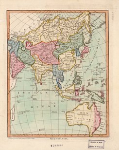
In the 1700s, the Eastern world comprised the continents of Asia and Australia (New Holland).
The concept has been used in both "Eastern" and "Western" nations. Japanesesinologist Tachibana Shiraki, in the 1920s, wrote of the need to unify with China and some other Asian nations (excluding Central Asia and the Middle East) in forming a "New East" that might combine culturally in balancing against the West. Japan continued to make much of the concept, known as Pan-Asianism, throughout World War II, in propaganda. In China, it was encapsulated during the Cold War in a 1957 speech by Mao Zedong,
who launched a slogan when he said, "This is a war between two worlds.
The West Wind cannot prevail over the East Wind; the East Wind is bound
to prevail over the West Wind."
Muslim percentages: green 50% and above, yellow 10-49%
To Western writers, in the 1940s, it became bound up with an idea of
aggressive, "frustrated nationalism", which was seen as "intrinsically
anti- or non-Western"; sociologist Frank Furedi
wrote, "The already existing intellectual assessment of European
nationalism adapted to the growth of the Third World variety by
developing the couplet of mature Western versus immature Eastern
nationalism.... This East-West dichotomy became an accepted part of
Western political theory."
The 1978 book Orientalism, by Edward Said,
was highly influential in further establishing concepts of the
East–West dichotomy in the Western world, bringing into college lectures
a notion of the East as "characterized by religious sensibilities,
familial social orders, and ageless traditions" in contrast to Western
"rationality, material and technical dynamism, and individualism."
More recently, the divide has also been posited as an Islamic "East" and an American and European "West." Critics note that an Islamic/non-Islamic East–West dichotomy is complicated by the global dissemination of Islamic fundamentalism
and by cultural diversity within Islamic nations, moving the argument
"beyond that of an East-West dichotomy and into a tripartite situation."
Applications
The East–West dichotomy has been used in studying a range of topics, including management, economics and linguistics. Knowledge Creation and Management (2007) examines it as the difference in organizational learning between Western cultures and the Eastern world.
It has been widely used in exploring the period of rapid economic
growth that has been termed the "East-Asian miracle" in segments of East Asia, particularly the Asian Tigers, following World War II. Some sociologists, in line with the West as a model of modernity posited by Arnold J. Toynbee, have perceived the economic expansion as a sign of the "Westernization"
of the region, but others look for explanation in cultural/racial
characteristics of the East, embracing concepts of fixed Eastern
cultural identity in a phenomenon described as "New Orientalism". Both approaches to the East-West dichotomy have been criticized for failing to take into account the historical hybridity of the regions.
The concept has also been brought to bear on examinations of intercultural communication.
Asians are widely described as embracing an "inductive speech pattern"
in which a primary point is approached indirectly, but Western societies
are said to use "deductive speech" in which speakers immediately
establish their point.
That is attributed to a higher priority among Asians in harmonious
interrelations, but Westerners are said to prioritize direct
communication. 2001's Intercultural Communication: A Discourse Approach
described the East–West dichotomy linguistically as a "false
dichotomy", noting that both Asian and Western speakers use both forms
of communication.
Criticism
In
addition to difficulties in defining regions and overlooking hybridity,
the East–West dichotomy has been criticized for creating an artificial
construct of regional unification that allows one voice to claim
authority to speak for multitudes. In "The Triumph of the East?", Mark
T. Berger speaks to the issue as relates to examination of the
"East-Asian miracle":
The historical power of the East-West dichotomy, and the
fixed conceptions of culture/race to which it is linked, have
increasingly allowed the national elites of the region to speak not only
for their 'nations,' but even for Asia and Asians.... There are
numerous instances of Western scholars, intent on challenging North
American and/or Western hegemony in both material and discursive terms,
ending up uncritically privileging the elite narratives of power-holders
in Asia as authentic representatives of a particular non-Western nation
or social formation (and also contributing to the continued use of the
East-West dichotomy).
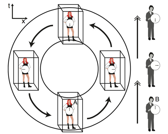
Physicists have come up with what they claim is a mathematical model of a theoretical "time machine" - a box that can move backwards and forwards through time and space.
The
trick, they say, is to use the curvature of space-time in the Universe
to bend time into a circle for hypothetical passengers sitting in the
box, and that circle allows them to skip into the future and the past.
"People think of time travel as something as fiction. And we tend to think it's not possible because we don't actually do it," said theoretical physicist and mathematician, Ben Tippett, from the University of British Columbia in Canada.
"But, mathematically, it is possible."
Together
with David Tsang, an astrophysicist at the University of Maryland,
Tippett used Einstein's theory of general relativity to come up with a
mathematical model of what they're calling a Traversable Acausal
Retrograde Domain in Space-time (yep, the acronym is literally TARDIS).
But
before we get into the madness of legit time travel, let's put this
into perspective real quick - the researchers aren't claiming to have a
blueprint for a Doctor Who-style time machine that can be built tomorrow.
They
say the materials we'd need to build this thing are so exotic, we
haven't even discovered them yet... but we'll get to that in a minute.
Firstly, let's talk about what Tippett and Tsang are actually proposing.
The model is based on the idea that instead of looking at the Universe in three spatial dimensions, with the fourth dimension (time) separated, we should be imagining those four dimensions simultaneously.
That allows us to consider the possibility of a space-time
continuum, where different directions in space and time are all
connected within the curved fabric of the Universe.
Einstein's
theory of relativity links gravitational effects in the Universe to a
curvature of space-time - the phenomenon thought to be behind the elliptical orbits of planets and stars.
If
space-time were 'flat' or uncurved, planets would move in straight
lines. But according to relativity, the geometry of space-time becomes
curved in the vicinity of high-mass objects, which causes planets to
bend their paths and rotate around their star instead.
What
Tippett and Tsang argue is that it's not just physical space that can be
bent and twisted in the Universe - time itself can also be curved in
the vicinity of high-mass objects.
"The time direction of the
space-time surface also shows curvature. There is evidence showing the
closer to a black hole we get, time moves slower," said Tippett.
"My
model of a time machine uses the curved space-time to bend time into a
circle for the passengers, not in a straight line. That circle takes us
back in time."
In order to harness this theoretical property, the physicists
propose creating a kind of 'bubble' of space-time geometry, which
carries whatever's inside it through space and time along a large
circular path.
If this bubble can hit speeds greater than the
speed of light - something the pair say is mathematically possible -
this would allow it to move backwards in time.
"Delighted
external observers would be able to watch the time travellers within
the box evolving backwards in time: un-breaking eggs and separating
cream from their coffee."
You can see the basic idea in the image
below, with a passenger inside the bubble/time machine (person A), and
an external observer standing beside it (person B).
The arrow of time - which under normal circumstances (in our Universe, at least) always points forward, making the past become the present - is represented by the black arrows:
B. K. Tippett et. al.
Both person A and person B will experience time in dramatically different ways, the researchers explained:
"Within the bubble, A will see the B's events periodically evolve,
and then reverse. Outside the bubble, observer B will see two versions
of A emerge from the same location: one's clock hands will turn
clockwise, the other counterclockwise."
In other words, the external observer would see two versions of
the objects inside the time machine: one version evolving forwards in
time, the other backwards.
While Tippett and Tsang say the maths
is sound, the problem now is we don't actually have the right materials
to build what they're proposing.
"While is it mathematically
feasible, it is not yet possible to build a space-time machine because
we need materials - which we call exotic matter - to bend space-time in
these impossible ways, but they have yet to be discovered," said Tippett.
Their idea recalls another theoretical time machine - the Alcubierre drive, which would also use a shell of exotic matter to transport passengers through time and space (hypothetically).
Both
ideas can't go very far without some idea of how to actually produce
these space-time-bending materials, but as Tippett points out, we're
never going to stop wondering about the possibilities of time travel,
and this is just one more direction we can take this mind-bending
physics.
"Studying space-time is both fascinating and problematic," he said.
"Experts
in my field have been exploring the possibility of mathematical time
machines since 1949, and my research presents a new method for doing
it."
The term "cradle of civilization" refers to locations where, according to current archeological data, civilization
is understood to have emerged. Current thinking is that there was no
single "cradle", but several civilizations that developed independently,
with the Fertile Crescent (Mesopotamia and Ancient Egypt) understood to be the earliest. Other civilizations arose in Asia among cultures situated along large river valleys, such as the Indo-Gangetic Plain in Ancient India and the Yellow River in Ancient China. The extent to which there was significant influence between the early civilizations of West Asia and those of East Asia is disputed. Scholars accept that the civilizations of Mesoamerica, mainly in modern Mexico, and Norte Chico in present-day Peru emerged independently from those in Eurasia.
Scholars have defined civilization using various criteria such as
the use of writing, cities, a class-based society, agriculture, animal
husbandry, public buildings, metallurgy, and monumental architecture. The term cradle of civilization has frequently been applied to a variety of cultures and areas, in particular the Ancient Near EasternChalcolithic (Ubaid period) and Fertile Crescent, Ancient India and Ancient China. It has also been applied to ancient Anatolia, the Levant and Iranian plateau, and used to refer to culture predecessors—such as Ancient Greece as the predecessor of Western civilization—even when such sites are not understood as an independent development of civilization, as well as within national rhetoric.
History of the idea
The concept "cradle of civilization" is the subject of much debate. The figurative use of cradle to mean "the place or region in which anything is nurtured or sheltered in its earlier stage" is traced by the Oxford English Dictionary to Spenser (1590). Charles Rollin's Ancient History (1734) has "Egypt that served at first as the cradle of the holy nation".
The earliest signs of a process leading to sedentary culture can be seen in the Levant to as early as 12,000 BC, when the Natufian culture became sedentary; it evolved into an agricultural society by 10,000 BC.
The importance of water to safeguard an abundant and stable food
supply, due to favourable conditions for hunting, fishing and gathering
resources including cereals, provided an initial wide spectrum economy that triggered the creation of permanent villages.
The earliest proto-urban settlements with several thousand inhabitants emerged in the Neolithic. The first cities to house several tens of thousands were Memphis and Uruk, by the 31st century BC.
Historic times are marked apart from prehistoric times when "records of the past begin to be kept for the benefit of future generations"; which may be in written or oral form. If the rise of civilization is taken to coincide with the development of writing out of proto-writing, the Near Eastern Chalcolithic, the transitional period between the Neolithic and the Bronze Age during the 4th millennium BC, and the development of proto-writing in Harappa in the Indus Valley of South Asia around 3300 BC are the earliest incidences, followed by Chinese proto-writing evolving into the oracle bone script, and again by the emergence of Mesoamerican writing systems from about 900 BC.
In the absence of written documents, most aspects of the rise of
early civilizations are contained in archaeological assessments that
document the development of formal institutions and the material
culture. A "civilized" way of life is ultimately linked to conditions
coming almost exclusively from intensive agriculture. Gordon Childe defined the development of civilization as the result of two successive revolutions: the Neolithic Revolution, triggering the development of settled communities, and the Urban Revolution,
which enhanced tendencies towards dense settlements, specialized
occupational groups, social classes, exploitation of surpluses,
monumental public buildings and writing. Few of those conditions,
however, are unchallenged by the records: dense settlements were not
attested in Egypt's Old Kingdom and were absent in the Maya area; the Incas
lacked writing altogether; and often monumental architecture preceded
any indication of village settlement. For instance, in present-day
Louisiana, researchers have determined that cultures that were primarily
nomadic organized over generations to build earthwork mounds at
seasonal settlements as early as 3400 BC. Rather than a succession of
events and preconditions, the rise of civilization could equally be
hypothesized as an accelerated process that started with incipient
agriculture and culminated in the Oriental Bronze Age.
Single or multiple cradles
A traditional theory of the spread of civilization is that it began in the Fertile Crescent and spread out from there by influence.
Scholars more generally now believe that civilizations arose
independently at several locations in both hemispheres. They have
observed that sociocultural developments occurred along different
timeframes. "Sedentary" and "nomadic"
communities continued to interact considerably; they were not strictly
divided among widely different cultural groups. The concept of a cradle
of civilization has a focus where the inhabitants came to build cities, to create writing systems, to experiment in techniques for making pottery and using metals, to domesticate animals, and to develop complex social structures involving class systems.
Current scholarship generally identifies five sites where civilization emerged independently:
Around 10,200 BC the first fully developed Neolithic cultures belonging to the phases Pre-Pottery Neolithic A (PPNA) and Pre-Pottery Neolithic B (7600 to 6000 BC) appeared in the Fertile Crescent and from there spread eastwards and westwards. One of the most notable PPNA settlements is Jericho in the Levant region, thought to be the world's first town (settled around 8500 BC and fortified around 6800 BC). In Mesopotamia,
the convergence of the Tigris and Euphrates rivers produced rich
fertile soil and a supply of water for irrigation. The civilizations
that emerged around these rivers are among the earliest known non-nomadicagrarian societies.
It is because of this that the Fertile Crescent region, and Mesopotamia
in particular, are often referred to as the cradle of civilization. The period known as the Ubaid period (c. 6500 to 3800 BC) is the earliest known period on the alluvial plain, although it is likely earlier periods exist obscured under the alluvium.
It was during the Ubaid period that the movement towards urbanization
began. Agriculture and animal husbandry were widely practiced in
sedentary communities, particularly in Northern Mesopotamia, and
intensive irrigated hydraulic agriculture began to be practiced in the
south. Around 6000 BC, Neolithic settlements appear all over Egypt. Studies based on morphological, genetic, and archaeological data have attributed these settlements to migrants from the Fertile Crescent in the Near East returning during the Egyptian and North African Neolithic, bringing agriculture to the region. Eridu is the oldest Sumerian site settled during this period, around 5300 BC, and the city of Ur also first dates to the end of this period. In the south, the Ubaid period had a very long duration from around 6500 to 3800 BC; when it is replaced by the Uruk period.
Sumerian civilization coalesces in the subsequent Uruk period (4000 to 3100 BC). Named after the Sumerian city of Uruk, this period saw the emergence of urban life in Mesopotamia and, during its later phase, the gradual emergence of the cuneiform script. Proto-writing in the region dates to around 3500 BC, with the earliest texts dating to 3300 BC; early cuneiform writing emerged in 3000 BC. It was also during this period that pottery painting declined as copper started to become popular, along with cylinder seals. Sumerian cities during the Uruk period were probably theocratic and were most likely headed by a priest-king (ensi), assisted by a council of elders, including both men and women.[45] It is quite possible that the later Sumerian pantheon was modeled upon this political structure. Uruk trade networks started to expand to other parts of Mesopotamia and as far as North Caucasus, and strong signs of governmental organization and social stratification began to emerge leading to the Early Dynastic Period (c. 2900 BC). The Jemdet Nasr period,
which is generally dated from 3100–2900 BC and succeeds the Uruk
period, is known as one of the formative stages in the development of
the cuneiform script. The oldest clay tablets come from Uruk and date to
the late fourth millennium BC, slightly earlier than the Jemdet Nasr
Period. By the time of the Jemdet Nasr Period, the script had already
undergone a number of significant changes. It originally consisted of pictographs,
but by the time of the Jemdet Nasr Period it was already adopting
simpler and more abstract designs. It is also during this period that
the script acquired its iconic wedge-shaped appearance. At the end of the Jemdet Nasr period there was a major archaeologically attested river flood in Shuruppak
and other parts of Mesopotamia. Polychrome pottery from a destruction
level below the flood deposit has been dated to immediately before the
Early Dynastic Period around 2900 BC.
After the Early Dynastic period begins, there was a shift in
control of the city-states from the temple establishment headed by
council of elders led by a priestly "En" (a male figure when it was a
temple for a goddess, or a female figure when headed by a male god) towards a more secular Lugal (Lu = man, Gal = great) and includes such legendary patriarchal figures as Enmerkar, Lugalbanda and Gilgamesh—who
are supposed to have reigned shortly before the historic record opens
c. 2700 BC, when the now deciphered syllabic writing started to develop
from the early pictograms. The center of Sumerian culture remained in
southern Mesopotamia, even though rulers soon began expanding into
neighboring areas, and neighboring Semitic groups adopted much of
Sumerian culture for their own. The earliest ziggurats
began near the end of the Early Dynastic Period, although architectural
precursors in the form of raised platforms date back to the Ubaid
period,. The well-known Sumerian King List
dates to the early second millennium BC. It consists of a succession of
royal dynasties from different Sumerian cities, ranging back into the
Early Dynastic Period. Each dynasty rises to prominence and dominates
the region, only to be replaced by the next. The document was used by
later Mesopotamian kings to legitimize their rule. While some of the
information in the list can be checked against other texts such as
economic documents, much of it is probably purely fictional, and its use
as a historical document is limited.
Eannatum, the Sumerian king of Lagash, established one of the first verifiable empires in history in 2500 BC. The neighboring Elam, in modern Iran, was also part of the early urbanization during the Chalcolithic period. Elamite states were among the leading political forces of the Ancient Near East.
The emergence of Elamite written records from around 3000 BC also
parallels Sumerian history, where slightly earlier records have been
found. During the 3rd millennium BC, there developed a very intimate cultural symbiosis between the Sumerians and the Akkadians. Akkadian gradually replaced Sumerian as a spoken language somewhere between the 3rd and the 2nd millennia BC. The Semitic-speaking Akkadian empire emerged around 2350 BC under Sargon the Great.
The Akkadian Empire reached its political peak between the 24th and
22nd centuries BC. Under Sargon and his successors, the Akkadian
language was briefly imposed on neighboring conquered states such as Elam and Gutium. After the fall of the Akkadian Empire and the overthrow of the Gutians, there was a brief reassertion of Sumerian dominance in Mesopotamia under the Third Dynasty of Ur.
After the final collapse of Sumerian hegemony in Mesopotamia around
2004 BC, the Semitic Akkadian people of Mesopotamia eventually coalesced
into two major Akkadian-speaking nations: Assyria in the north, and, a few centuries later, Babylonia in the south.
India
The Indus Valley Civilization at its greatest extent
One of the earliest Neolithic sites in the Indian subcontinent is Bhirrana along the ancient Saraswati riverine system in the present day state of Haryana in India, dating to around 7600 BC. Other early sites include Lahuradewa in the Middle Ganges region and Jhusi near the confluence of Ganges and Yamuna rivers, both dating to around the 7000 BC. The aceramic Neolithic at Mehrgarh
lasts from 7000 to 5500 BC, with the ceramic Neolithic at Mehrgarh
lasting up to 3300 BC; blending into the Early Bronze Age. Mehrgarh is
one of the earliest sites with evidence of farming and herding in the
Indian subcontinent. It is likely that the culture centered around Mehrgarh migrated into the Indus Valley and became the Indus Valley Civilisation. The earliest fortified town in the region is found at Rehman Dheri, dated 4000 BC in Khyber Pakhtunkhwa close to River Zhob Valley. Other fortified towns found to date are at Amri (3600–3300 BC), Kot Diji in Sindh, and at Kalibangan (3000 BC) at the Hakra River.
The Indus Valley Civilisation starts around 3300 BC with what is
referred to as the Early Harappan Phase (3300 to 2600 BC). The earliest
examples of the Indus Script date to this period, as well as the emergence of citadels representing centralised authority and an increasingly urban quality of life. Trade networks linked this culture with related regional cultures and distant sources of raw materials, including lapis lazuli and other materials for bead-making. By this time, villagers had domesticated numerous crops, including peas, sesame seeds, dates, and cotton, as well as animals, including the water buffalo.
2600 BC marks the Mature Harappan Phase during which Early Harappan communities turned into large urban centres including Harappa, Dholavira, Mohenjo-Daro, Lothal, Rupar, and Rakhigarhi, and more than 1,000 towns and villages, often of relatively small size. Mature Harappans evolved new techniques in metallurgy and produced copper, bronze, lead, and tin and displayed advanced levels of engineering. As seen in Harappa, Mohenjo-daro and the recently partially excavated Rakhigarhi, this urban plan included the world's first known urban sanitation systems: see hydraulic engineering of the Indus Valley Civilisation. Within the city, individual homes or groups of homes obtained water from wells. From a room that appears to have been set aside for bathing, waste water was directed to covered drains, which lined the major streets. Houses opened only to inner courtyards
and smaller lanes. The house-building in some villages in the region
still resembles in some respects the house-building of the Harappans. The advanced architecture of the Harappans is shown by their impressive dockyards, granaries,
warehouses, brick platforms, and protective walls. The massive walls of
Indus cities most likely protected the Harappans from floods and may
have dissuaded military conflicts.
The people of the Indus Civilisation achieved great accuracy in
measuring length, mass, and time. They were among the first to develop a
system of uniform weights and measures. A comparison of available
objects indicates large scale variation across the Indus territories.
Their smallest division, which is marked on an ivory scale found in Lothal in Gujarat, was approximately 1.704 mm, the smallest division ever recorded on a scale of the Bronze Age.
Harappan engineers followed the decimal division of measurement for all
practical purposes, including the measurement of mass as revealed by
their hexahedron weights. These chert
weights were in a ratio of 5:2:1 with weights of 0.05, 0.1, 0.2, 0.5,
1, 2, 5, 10, 20, 50, 100, 200, and 500 units, with each unit weighing
approximately 28 grams, similar to the English Imperial ounce
or Greek uncia, and smaller objects were weighed in similar ratios with
the units of 0.871. However, as in other cultures, actual weights were
not uniform throughout the area. The weights and measures later used in Kautilya's Arthashastra (4th century BC) are the same as those used in Lothal.
Around 1800 BC, signs of a gradual decline began to emerge, and
by around 1700 BC most of the cities had been abandoned.Suggested
contributory causes for the localisation of the IVC include changes in
the course of the river, and climate change that is also signalled for the neighbouring areas of the Middle East. As of 2016
many scholars believe that drought lead to a decline in trade with
Egypt and Mesopotamia contributing to the collapse of the Indus
Civilisation. The Ghaggar-Hakra system was rain-fed,
and water-supply depended on the monsoons. The Indus Valley climate
grew significantly cooler and drier from about 1800 BC, linked to a
general weakening of the monsoon at that time.
The Indian monsoon declined and aridity increased, with the
Ghaggar-Hakra retracting its reach towards the foothills of the
Himalaya,
leading to erratic and less extensive floods that made inundation
agriculture less sustainable. Aridification reduced the water supply
enough to cause the civilisation's demise, and to scatter its population
eastward.
As the monsoons kept shifting south, the floods grew too erratic for
sustainable agricultural activities. The residents then migrated towards
the Ganges basin in the east, where they established smaller villages
and isolated farms. However trade with the old cities did not flourish.
The small surplus produced in these small communities did not allow
development of trade, and the cities died out. The Indo-Aryan peoples migrated into the Indus River Valley during this period and began the Vedic age of India.
The Indus Valley Civilisation did not disappear suddenly and many
elements of the civilization continued in later Indian subcontinent and
Vedic cultures.
China
Traditional Xia sites (black) and Erlitou sites (red)
Drawing on archaeology, geology and anthropology, modern scholars do not see the origins of the Chinese civilization or history as a linear story but rather the history of the interactions of different and distinct cultures and ethnic groups that influenced each other's development. The two specific cultural regions that developed Chinese civilization was the Yellow River civilization and the Yangtze civilization. Early evidence for Chinese millet agriculture is dated to around 7000 BC, with the earliest evidence of cultivated rice found at Chengtoushan near the Yangtze River, dated to 6500 BC. Chengtoushan may also be the site of the first walled city in China. By the beginning of the Neolithic Revolution, the Yellow River valley began to establish itself as a center of the Peiligang culture which flourished from 7000 to 5000 BC, with evidence of agriculture, constructed buildings, pottery, and burial of the dead.
With agriculture came increased population, the ability to store and
redistribute crops, and the potential to support specialist craftsmen
and administrators. Its most prominent site is Jiahu. Some scholars have suggested that the Jiahu symbols (6600 BC) are the earliest form of proto-writing in China.
However, it is likely that they should not be understood as writing
itself, but as features of a lengthy period of sign-use which led
eventually to a fully-fledged system of writing.
Archaeologists believe that the Peiligang culture was egalitarian, with
little political organization. It would eventually evolve into the Yangshao culture (5000 to 3000 BC), and their stone tools were polished and highly specialized. They may also have practiced an early form of silkworm cultivation.. The main food of the Yangshao people was millet, with some sites using foxtail millet and others broom-corn millet, though some evidence of rice has been found. The exact nature of Yangshao agriculture, small-scale slash-and-burn
cultivation versus intensive agriculture in permanent fields, is
currently a matter of debate. Once the soil was exhausted, residents
picked up their belongings, moved to new lands, and constructed new
villages.
However, Middle Yangshao settlements such as Jiangzhi contain
raised-floor buildings that may have been used for the storage of
surplus grains. Grinding stones for making flour were also found. Later, Yangshao culture was superseded by the Longshan culture, which was also centered on the Yellow River from about 3000 to 1900 BC, its most prominent site being Taosi. The population expanded dramatically during the 3rd millennium BC, with many settlements having rammed earth walls. It decreased in most areas around 2000 BC until the central area evolved into the Bronze AgeErlitou culture. The earliest bronze artifacts have been found in the Majiayao culture site (3100 to 2700 BC).
Chinese civilization begins during the second phase of the Erlitou period (1900 to 1500 BC), with Erlitou considered the first state level society of East Asia. There is considerable debate whether Erlitou sites correlate to the semi-legendary Xia dynasty. The Xia dynasty (2070 to 1600 BC) is the first dynasty to be described in ancient Chinese historical records such as the Bamboo Annals,
first published more than a millennium later during the Western Zhou
period. Although Xia is an important element in Chinese historiography,
there is to date no contemporary written evidence to corroborate the
dynasty. Erlitou saw an increase in bronze metallurgy and urbanization and was a rapidly growing regional center with palatial complexes that provide evidence for social stratification. The Erlitou civilization is divided into four phases, each of roughly
50 years. During Phase I, covering 100 hectares (250 acres), Erlitou was
a rapidly growing regional center with estimated population of several
thousand but not yet an urban civilization or capital. Urbanization began in Phase II, expanding to 300 ha (740 acres) with a population around 11,000.
A palace area of 12 ha (30 acres) was demarcated by four roads. It
contained the 150x50 m Palace 3, composed of three courtyards along a
150-meter axis, and Palace 5. A bronze foundry was established to the south of the palatial complex that was controlled by the elite who lived in palaces. The city reached its peak in Phase III, and may have had a population of around 24,000.
The palatial complex was surrounded by a two-meter-thick rammed-earth
wall, and Palaces 1, 7, 8, 9 were built. The earthwork volume of rammed
earth for the base of largest Palace 1 is 20,000 m³ at least. Palaces 3 and 5 were abandoned and replaced by 4,200-square-kilometer (4.5×10¹⁰ sq ft) Palace 2 and Palace 4.
In Phase IV, the population decreased to around 20,000, but building
continued. Palace 6 was built as an extension of Palace 2, and Palaces
10 and 11 were built. Phase IV overlaps with the Lower phase of the Erligang culture (1600–1450 BC). Around 1600 to 1560 BC, about 6 km northeast of Erlitou, Eligang cultural walled city was built at Yanshi, which coincides with an increase in production of arrowheads at Erlitou. This situation might indicate that the Yanshi City was competing for power and dominance with Erlitou.
Production of bronzes and other elite goods ceased at the end of Phase
IV, at the same time as the Erligang city of Zhengzhou was established
85 km (53 mi) to the east. There is no evidence of destruction by fire
or war, but, during the Upper Erligang phase (1450–1300 BC), all the
palaces were abandoned, and Erlitou was reduced to a village of 30 ha
(74 acres).
The earliest traditional Chinese dynasty for which there is both archeological and written evidence is the Shang dynasty (1600 to 1046 BC). Shang sites have yielded the earliest known body of Chinese writing, the oracle bone script, mostly divinations
inscribed on bones. These inscriptions provide critical insight into
many topics from the politics, economy, and religious practices to the
art and medicine of this early stage of Chinese civilization. Some historians argue that Erlitou should be considered an early phase of the Shang dynasty. The U.S. National Gallery of Art
defines the Chinese Bronze Age as the period between about 2000 and 771
BC; a period that begins with the Erlitou culture and ends abruptly
with the disintegration of Western Zhou rule. The Sanxingdui
culture is another Chinese Bronze Age society, contemporaneous to the
Shang dynasty, however they developed a different method of
bronze-making from the Shang.
Andes
Map of Norte Chico sites showing their locations in Peru
The earliest evidence of agriculture in the Andean region dates to around 4700 BC at Huaca Prieta and Paredones. The oldest evidence of canal irrigation in South America dates to 4700 to 2500 BC in the Zaña Valley of northern Peru. The earliest urban settlements of the Andes, as well as North and South America, are dated to 3500 BC at Huaricanga, in the Fortaleza area, and Sechin Bajo near the Sechin River.
The Norte Chico civilization
proper is understood to have emerged around 3200 BC, as it is at that
point that large-scale human settlement and communal construction across
multiple sites becomes clearly apparent. Since the early 21st century, it has been established as the oldest known civilization in the Americas.
The civilization flourished at the confluence of three rivers, the
Fortaleza, the Pativilca, and the Supe. These river valleys each have
large clusters of sites. Further south, there are several associated
sites along the Huaura River. Notable settlements include the cities of Caral, the largest and most complex Preceramic site, and Aspero. Norte Chico sites are known for their density of large sites with immense architecture.
Haas argues that the density of sites in such a small area is globally
unique for a nascent civilization. During the third millennium BC, Norte
Chico may have been the most densely populated area of the world
(excepting, possibly, northern China). The Supe, Pativilca, Fortaleza, and Huaura River valleys each have several related sites.
Norte Chico is unusual in that it completely lacked ceramics and
apparently had almost no visual art. Nevertheless, the civilization
exhibited impressive architectural feats, including large earthwork
platform mounds and sunken circular plazas, and an advanced textile
industry.
The platform mounds, as well as large stone warehouses, provide
evidence for a stratified society and a centralized authority necessary
to distribute resources such as cotton. However, there is no evidence of warfare or defensive structures during this period.
Originally, it was theorized that, unlike other early civilizations,
Norte Chico developed by relying on maritime food sources in place of a
staple cereal. This hypothesis, the Maritime Foundation of Andean Civilization,
is still hotly debated; however, most researches now agree that
agriculture played a central role in the civilization's development
while still acknowledging a strong supplemental reliance on maritime
proteins.
The Norte Chico chiefdoms were "almost certainly theocratic,
though not brutally so", according to Mann. Construction areas show
possible evidence of feasting, which would have included music and
likely alcohol, suggesting an elite able to both mobilize and reward the
population.
The degree of centralized authority is difficult to ascertain, but
architectural construction patterns are indicative of an elite that, at
least in certain places at certain times, wielded considerable power:
while some of the monumental architecture was constructed incrementally,
other buildings, such as the two main platform mounds at Caral, appear to have been constructed in one or two intense construction phases. As further evidence of centralized control, Haas points to remains of large stone warehouses found at Upaca, on the Pativilca, as emblematic of authorities able to control vital resources such as cotton.
Economic authority would have rested on the control of cotton and
edible plants and associated trade relationships, with power centered on
the inland sites. Haas tentatively suggests that the scope of this
economic power base may have extended widely: there are only two
confirmed shore sites in the Norte Chico (Aspero and Bandurria) and
possibly two more, but cotton fishing nets and domesticated plants have
been found up and down the Peruvian coast. It is possible that the major
inland centers of Norte Chico were at the center of a broad regional
trade network centered on these resources.
Discover
magazine, citing Shady, suggests a rich and varied trade life: "[Caral]
exported its own products and those of Aspero to distant communities in
exchange for exotic imports: Spondylus shells from the coast of Ecuador, rich dyes from the Andean highlands, hallucinogenicsnuff from the Amazon."
(Given the still limited extent of Norte Chico research, such claims
should be treated circumspectly.) Other reports on Shady's work indicate
Caral traded with communities in the jungle farther inland and,
possibly, with people from the mountains.
Leaders' ideological power was based on apparent access to deities and the supernatural. Evidence regarding Norte Chico religion is limited: an image of the Staff God, a leering figure with a hood and fangs, has been found on a gourd
dated to 2250 BC. The Staff God is a major deity of later Andean
cultures, and Winifred Creamer suggests the find points to worship of
common symbols of gods. As with much other research at Norte Chico, the nature and significance of the find has been disputed by other researchers.
The act of architectural construction and maintenance may also have
been a spiritual or religious experience: a process of communal
exaltation and ceremony. Shady has called Caral "the sacred city" (la ciudad sagrada):
socio-economic and political focus was on the temples, which were
periodically remodeled, with major burnt offerings associated with the
remodeling.
The discovery of quipu, string-based recording devices, at Caral can be understood as a form of "proto-writing" at Norte Chico. However, the exact use of quipu in this and later Andean cultures has been widely debated. Additionally, the image of the Staff God has been found on a gourd
dated to 2250 BC. The Staff God is a major deity of later Andean
cultures. The presence of quipu and the commonality of religious symbols
suggests a cultural link between Norte Chico and later Andean cultures.
Circa 1800 BC, the Norte Chico civilization began to decline,
with more powerful centers appearing to the south and north along the
coast and to the east inside the belt of the Andes. Pottery eventually developed in the Amazon Basin
and spread to the Andean culture region around 2000 BC. The next major
civilization to arise in the Andes would be the Chavín culture at Chavín de Huantar, located in the Andean highlands of the present-day Ancash Region. It is believed to have been built around 900 BC and was the religious and political center of the Chavín people.
Mesoamerica
The Olmec heartland, where the Olmec reigned
The Coxcatlan caves in the Valley of Tehuacán provide evidence for agriculture in components dated between 5000 and 3400 BC. Similarly, sites such as Sipacate in Guatemala provide maize pollen samples dating to 3500 BC. It is estimated that fully domesticated maize developed in Mesoamerica around 2700 BC. Mesoamericans during this period likely divided their time between small hunting encampments and large temporary villages. Around 1900 BC, the Mokaya domesticated one of the dozen species of cacao. A Mokaya archaeological site provides evidence of cacao beverages dating to this time.
The Mokaya are also thought to have been among the first cultures in
Mesoamerica to develop a hierarchical society. What would become the
Olmec civilization had its roots in early farming cultures of Tabasco, which began around 5100 to 4600 BC.
The emergence of the Olmec civilization has traditionally been dated to around 1600 to 1500 BC. Olmec features first emerged in the city of San Lorenzo Tenochtitlán,
fully coalescing around 1400 BC. The rise of civilization was assisted
by the local ecology of well-watered alluvial soil, as well as by the
transportation network provided by the Coatzacoalcos River basin. This environment encouraged a densely concentrated population, which in turn triggered the rise of an elite class and an associated demand for the production of the symbolic and sophisticated luxury artifacts that define Olmec culture. Many of these luxury artifacts were made from materials such as jade, obsidian, and magnetite,
which came from distant locations and suggest that early Olmec elites
had access to an extensive trading network in Mesoamerica. The aspect of
Olmec culture perhaps most familiar today is their artwork,
particularly the Olmec colossal heads. San Lorenzo was situated in the midst of a large agricultural area.
San Lorenzo seems to have been largely a ceremonial site, a town
without city walls, centered in the midst of a widespread
medium-to-large agricultural population. The ceremonial center and
attendant buildings could have housed 5,500 while the entire area,
including hinterlands, could have reached 13,000.
It is thought that while San Lorenzo controlled much or all of the
Coatzacoalcos basin, areas to the east (such as the area where La Venta
would rise to prominence) and north-northwest (such as the Tuxtla Mountains) were home to independent polities. San Lorenzo was all but abandoned around 900 BC at about the same time that La Venta
rose to prominence. A wholesale destruction of many San Lorenzo
monuments occurred around 950 BC. A wholesale destruction of many San
Lorenzo monuments also occurred circa 950 BC, which may indicate an internal uprising or, less likely, an invasion.
The latest thinking, however, is that environmental changes may have
been responsible for this shift in Olmec centers, with certain important
rivers changing course.
La Venta became the cultural capital of the Olmec concentration
in the region until its abandonment around 400 BC; constructing
monumental architectural achievements such as the Great Pyramid of La Venta.
It contained a “concentration of power,” as reflected by the sheer
enormity of the architecture and the extreme value of the artifacts
uncovered.
La Venta is perhaps the largest Olmec city and it was controlled and
expanded by an extremely complex hierarchical system with a king, as the
ruler and the elites below him. Priests had power and influence over
life and death and likely great political sway as well. Unfortunately,
not much is known about the political or social structure of the Olmec,
though new dating techniques might, at some point, reveal more
information about this elusive culture. It is possible that the signs of
status exist in the artifacts recovered at the site such as depictions
of feathered headdresses or of individuals wearing a mirror on their
chest or forehead.
“High-status objects were a significant source of power in the La Venta
polity political power, economic power, and ideological power. They
were tools used by the elite to enhance and maintain rights to
rulership.”
It has been estimated that La Venta would need to be supported by a
population of at least 18,000 people during its principal occupation.
To add to the mystique of La Venta, the alluvial soil did not preserve
skeletal remains, so it is difficult to observe differences in burials. However, colossal heads provide proof that the elite had some control
over the lower classes, as their construction would have been extremely
labor-intensive. “Other features similarly indicate that many laborers
were involved.”
In addition, excavations over the years have discovered that different
parts of the site were likely reserved for elites and other parts for
non-elites. This segregation of the city indicates that there must have
been social classes and therefore social inequality.
The exact cause of the decline of the Olmec culture is uncertain.
Between 400 and 350 BC, the population in the eastern half of the Olmec
heartland dropped precipitously.
This depopulation was probably the result of serious environmental
changes that rendered the region unsuited for large groups of farmers,
in particular changes to the riverine
environment that the Olmec depended upon for agriculture, hunting and
gathering, and transportation. These changes may have been triggered by tectonic upheavals or subsidence, or the silting up of rivers due to agricultural practices. Within a few hundred years of the abandonment of the last Olmec cities, successor cultures became firmly established. The Tres Zapotes
site, on the western edge of the Olmec heartland, continued to be
occupied well past 400 BC, but without the hallmarks of the Olmec
culture. This post-Olmec culture, often labeled Epi-Olmec, has features similar to those found at Izapa, some 550 km (330 miles) to the southeast.
The Olmecs are sometimes referred to as the mother culture of
Mesoamerica, as they were the first Mesoamerican civilization and laid
many of the foundations for the civilizations that followed. However, the causes and degree of Olmec influences on Mesoamerican cultures has been a subject of debate over many decades. Practices introduced by the Olmec include ritual bloodletting and the Mesoamerican ballgame; hallmarks of subsequent Mesoamerican societies such as the Maya and Aztec. Although the Mesoamerican writing system would fully develop later, early Olmec ceramics show representations that may be interpreted as codices.
There is academic consensus that Classical Greece is the seminal culture which provided the foundation of modern Western culture, democracy, art, theatre, philosophy and science. For this reason it is known as the cradle of Western Civilization. Along with Greece, Rome
has sometimes been described as a birthplace or as the cradle of
Western Civilization because of the role the city had in politics, republicanism, law, architecture, warfare and Western Christianity.


.png)


