Search This Blog

Wednesday, March 18, 2015

Map


From Wikipedia, the free encyclopedia


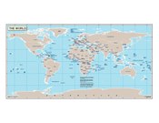
World map (2004, CIA World Factbook)

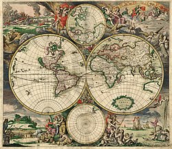
World map (1689, Amsterdam)

A map is a symbolic depiction highlighting relationships between elements of some space, such as objects, regions, and themes.

Many maps are static two-dimensional, geometrically accurate (or approximately accurate) representations of three-dimensional space, while others are dynamic or interactive, even three-dimensional. Although most commonly used to depict geography, maps may represent any space, real or imagined, without regard to context or scale; e.g. brain mapping, DNA mapping and extraterrestrial mapping.

Although the earliest maps known are of the heavens, geographic maps of territory have a very long tradition and exist from ancient times. The word "map" comes from the medieval Latin Mappa mundi, wherein mappa meant napkin or cloth and mundi the world. Thus, "map" became the shortened term referring to a two-dimensional representation of the surface of the world.

Geographic maps


A celestial map from the 17th century, by the cartographer Frederik de Wit.

Cartography or map-making is the study and practice of crafting representations of the Earth upon a flat surface (see History of cartography), and one who makes maps is called a cartographer.

Road maps are perhaps the most widely used maps today, and form a subset of navigational maps, which also include aeronautical and nautical charts, railroad network maps, and hiking and bicycling maps. In terms of quantity, the largest number of drawn map sheets is probably made up by local surveys, carried out by municipalities, utilities, tax assessors, emergency services providers, and other local agencies. Many national surveying projects have been carried out by the military, such as the British Ordnance Survey: a civilian government agency, internationally renowned for its comprehensively detailed work.

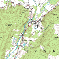
In addition to location information maps may also be used to portray contour lines indicating constant values of elevation, temperature, rainfall, etc.

Orientation of maps


The Hereford Mappa Mundi, about 1300, Hereford Cathedral, England. A classic "T-O" map with Jerusalem at centre, east toward the top, Europe the bottom left and Africa on the right.

The orientation of a map is the relationship between the directions on the map and the corresponding compass directions in reality. The word "orient" is derived from Latin oriens, meaning East. In the Middle Ages many maps, including the T and O maps, were drawn with East at the top (meaning that the direction "up" on the map corresponds to East on the compass). Today, the most common – but far from universal – cartographic convention is that North is at the top of a map. Several kinds of maps are often traditionally not oriented with North at the top:
  • Maps from non-Western traditions are oriented a variety of ways. Old maps of Edo show the Japanese imperial palace as the "top", but also at the centre, of the map. Labels on the map are oriented in such a way that you cannot read them properly unless you put the imperial palace above your head.[citation needed]
  • Medieval European T and O maps such as the Hereford Mappa Mundi were centred on Jerusalem with East at the top. Indeed, prior to the reintroduction of Ptolemy's Geography to Europe around 1400, there was no single convention in the West. Portolan charts, for example, are oriented to the shores they describe.
  • Maps of cities bordering a sea are often conventionally oriented with the sea at the top.
  • Route and channel maps have traditionally been oriented to the road or waterway they describe.
  • Polar maps of the Arctic or Antarctic regions are conventionally centred on the pole; the direction North would be towards or away from the centre of the map, respectively. Typical maps of the Arctic have 0° meridian towards the bottom of the page; maps of the Antarctic have the 0° meridian towards the top of the page.
  • Reversed maps, also known as Upside-Down maps or South-Up maps, reverse the "North is up" convention and have South at the top.
  • Buckminster Fuller's Dymaxion maps are based on a projection of the Earth's sphere onto an icosahedron. The resulting triangular pieces may be arranged in any order or orientation.
  • Modern digital GIS maps such as ArcMap typically project north at the top of the map, but use math degrees (0 is east, degrees increase counter-clockwise), rather than compass degrees (0 is north, degrees increase clockwise) for orientation of transects. Compass decimal degrees can be converted to math degrees by subtracting them from 450; if the answer is greater than 360, subtract 360.

Scale and accuracy


A 'global view map' of Europe, Western Asia and Africa.

Many, but not all, maps are drawn to a scale, expressed as a ratio such as 1:10,000, meaning that 1 of any unit of measurement on the map corresponds exactly, to 10,000 of that same unit on the ground. The scale statement may be taken as exact when the region mapped is small enough for the curvature of the Earth to be neglected, for example in a town planner's city map. Over larger regions where the curvature cannot be ignored we must use map projections from the curved surface of the Earth (sphere or ellipsoid) to the plane. The impossibility of flattening the sphere to the plane implies that no map projection can have constant scale: on most projections the best we can achieve is accurate scale on one or two lines (not necessarily straight) on the projection. Thus for map projections we must introduce the concept of point scale, which is a function of position, and strive to keep its variation within narrow bounds. Although the scale statement is nominal it is usually accurate enough for all but the most precise of measurements.

Large scale maps, say 1:10,000, cover relatively small regions in great detail and small scale maps, say 1:10,000,000, cover large regions such as nations, continents and the whole globe. The large/small terminology arose from the practice of writing scales as numerical fractions: 1/10,000 is larger than 1/10,000,000. There is no exact dividing line between large and small but 1/100,000 might well be considered as a medium scale. Examples of large scale maps are the 1:25,000 maps produced for hikers; on the other hand maps intended for motorists at 1:250,000 or 1:1,000,000 are small scale.

It is important to recognize that even the most accurate maps sacrifice a certain amount of accuracy in scale to deliver a greater visual usefulness to its user. For example, the width of roads and small streams are exaggerated when they are too narrow to be shown on the map at true scale; that is, on a printed map they would be narrower than could be perceived by the naked eye. The same applies to computer maps where the smallest unit is the pixel. A narrow stream say must be shown to have the width of a pixel even if at the map scale it would be a small fraction of the pixel width.

Cartogram: The EU distorted to show population distributions.

Some maps, called cartograms, have the scale deliberately distorted to reflect information other than land area or distance. For example, this map (at the right) of Europe has been distorted to show population distribution, while the rough shape of the continent is still discernible.

Another example of distorted scale is the famous London Underground map. The basic geographical structure is respected but the tube lines (and the River Thames) are smoothed to clarify the relationships between stations. Near the center of the map stations are spaced out more than near the edges of map.

Further inaccuracies may be deliberate. For example, cartographers may simply omit military installations or remove features solely in order to enhance the clarity of the map. For example, a road map may not show railroads, smaller waterways or other prominent non-road objects, and even if it does, it may show them less clearly (e.g. dashed or dotted lines/outlines) than the main roads. Known as decluttering, the practice makes the subject matter that the user is interested in easier to read, usually without sacrificing overall accuracy. Software-based maps often allow the user to toggle decluttering between ON, OFF and AUTO as needed. In AUTO the degree of decluttering is adjusted as the user changes the scale being displayed.

Map types and projections

Map of large underwater features. (1995, NOAA)

Maps of the world or large areas are often either 'political' or 'physical'. The most important purpose of the political map is to show territorial borders; the purpose of the physical is to show features of geography such as mountains, soil type or land use including infrastructure such as roads, railroads and buildings. Topographic maps show elevations and relief with contour lines or shading. Geological maps show not only the physical surface, but characteristics of the underlying rock, fault lines, and subsurface structures. Maps that depict the surface of the Earth also use a projection, a way of translating the three-dimensional real surface of the geoid to a two-dimensional picture. Perhaps the best-known world-map projection is the Mercator projection, originally designed as a form of nautical chart. Aeroplane pilots use aeronautical charts based on a Lambert conformal conic projection, in which a cone is laid over the section of the earth to be mapped. The cone intersects the sphere (the earth) at one or two parallels which are chosen as standard lines. This allows the pilots to plot a great-circle route approximation on a flat, two-dimensional chart.
  • Azimuthal or Gnomonic map projections are often used in planning air routes due to their ability to represent great circles as straight lines.
  • Richard Edes Harrison produced a striking series of maps during and after World War II for Fortune magazine. These used "bird's eye" projections to emphasise globally strategic "fronts" in the air age, pointing out proximities and barriers not apparent on a conventional rectangular projection of the world.

Electronic maps


From the last quarter of the 20th century, the indispensable tool of the cartographer has been the computer. Much of cartography, especially at the data-gathering survey level, has been subsumed by Geographic Information Systems (GIS). The functionality of maps has been greatly advanced by technology simplifying the superimposition of spatially located variables onto existing geographical maps. Having local information such as rainfall level, distribution of wildlife, or demographic data integrated within the map allows more efficient analysis and better decision making. In the pre-electronic age such superimposition of data led Dr. John Snow to identify the location of an outbreak of cholera. Today, it is used by agencies of the human kind, as diverse as wildlife conservationists and militaries around the world.

Relief map Sierra Nevada

Even when GIS is not involved, most cartographers now use a variety of computer graphics programs to generate new maps.

Interactive, computerised maps are commercially available, allowing users to zoom in or zoom out (respectively meaning to increase or decrease the scale), sometimes by replacing one map with another of different scale, centered where possible on the same point. In-car global navigation satellite systems are computerised maps with route-planning and advice facilities which monitor the user's position with the help of satellites. From the computer scientist's point of view, zooming in entails one or a combination of:
  1. replacing the map by a more detailed one
  2. enlarging the same map without enlarging the pixels, hence showing more detail by removing less information compared to the less detailed version
  3. enlarging the same map with the pixels enlarged (replaced by rectangles of pixels); no additional detail is shown, but, depending on the quality of one's vision, possibly more detail can be seen; if a computer display does not show adjacent pixels really separate, but overlapping instead (this does not apply for an LCD, but may apply for a cathode ray tube), then replacing a pixel by a rectangle of pixels does show more detail. A variation of this method is interpolation.

A world map in PDF format.

For example:
  • Typically (2) applies to a Portable Document Format (PDF) file or other format based on vector graphics. The increase in detail is, of course, limited to the information contained in the file: enlargement of a curve may eventually result in a series of standard geometric figures such as straight lines, arcs of circles or splines.
  • (2) may apply to text and (3) to the outline of a map feature such as a forest or building.
  • (1) may apply to the text as needed (displaying labels for more features), while (2) applies to the rest of the image. Text is not necessarily enlarged when zooming in. Similarly, a road represented by a double line may or may not become wider when one zooms in.
  • The map may also have layers which are partly raster graphics and partly vector graphics. For a single raster graphics image (2) applies until the pixels in the image file correspond to the pixels of the display, thereafter (3) applies.

Conventional signs

The various features shown on a map are represented by conventional signs or symbols. For example, colors can be used to indicate a classification of roads. Those signs are usually explained in the margin of the map, or on a separately published characteristic sheet.[1]

Some cartographers prefer to make the map cover practically the entire screen or sheet of paper, leaving no room "outside" the map for information about the map as a whole. These cartographers typically place such information in an otherwise "blank" region "inside" the map -- cartouche, map legend, title, compass rose, bar scale, etc. In particular, some maps contain smaller "sub-maps" in otherwise blank regions—often one at a much smaller scale showing the whole globe and where the whole map fits on that globe, and a few showing "regions of interest" at a larger scale in order to show details that wouldn't otherwise fit. Occasionally sub-maps use the same scale as the large map—a few maps of the contiguous United States include a sub-map to the same scale for each of the two non-contiguous states.

Labeling

To communicate spatial information effectively, features such as rivers, lakes, and cities need to be labeled. Over centuries cartographers have developed the art of placing names on even the densest of maps. Text placement or name placement can get mathematically very complex as the number of labels and map density increases.
Therefore, text placement is time-consuming and labor-intensive, so cartographers and GIS users have developed automatic label placement to ease this process.[2][3]

Non-geographical spatial maps

Maps exist of the solar system, and other cosmological features such as star maps. In addition maps of other bodies such as the Moon and other planets are technically not geographical maps.

Non spatial maps

Diagrams such as schematic diagrams and Gantt charts and treemaps display logical relationships between items, and do not display spatial relationships at all.

Some maps, for example the London Underground map, are topological maps. Topological in nature, the distances are completely unimportant; only the connectivity is significant.

General-purpose maps

General-purpose maps provide many types of information on one map. Most atlas maps, wall maps, and road maps fall into this category. The following are some features that might be shown on a general-purpose maps: bodies of water, roads, railway lines, parks, elevations, towns and cities, political boundaries, latitude and longitude, national and provincial parks. These maps give a broad understanding of location and features of an area. You can gain an understanding of the type of landscape, the location of urban places, and the location of major transportation routes all at once.

Types of maps

Legal regulation

Some countries required that all published maps represent their national claims regarding border disputes. For example:
  • Within Russia, Google Maps shows Crimea as part of Russia.[4]
  • Both India and the People's Republic of China require all maps show areas subject to the Sino-Indian border dispute in their own favor[5]
In 2010, the People's Republic of China began requiring that all online maps be served from within China, to enforce compliance with its laws.[6]

Astronaut


From Wikipedia, the free encyclopedia


NASA Astronaut Bruce McCandless II using a Manned Maneuvering Unit outside Space Shuttle Challenger on shuttle mission STS-41-B in 1984.

An astronaut (or cosmonaut) is a person trained by a human spaceflight program to command, pilot, or serve as a crew member of a spacecraft. Although generally reserved for professional space travelers, the terms are sometimes applied to anyone who travels into space, including scientists, politicians, journalists, and tourists.[1][2]

Starting in the 1950s up to 2002, astronauts were sponsored and trained exclusively by governments, either by the military or by civilian space agencies. With the suborbital flight of the privately funded SpaceShipOne in 2004, a new category of astronaut was created: the commercial astronaut.

Definition


The criteria for what constitutes human spaceflight vary. The Fédération Aéronautique Internationale (FAI) Sporting Code for astronautics recognizes only flights that exceed an altitude of 100 kilometers (62 mi).[3] In the United States, professional, military, and commercial astronauts who travel above an altitude of 50 miles (80 km)[4] are awarded astronaut wings.

As of 8 June 2013, a total of 532 people from 36 countries have reached 100 km (62 mi) or more in altitude, of which 529 reached low Earth orbit or beyond.[5][6] Of these, 24 people have traveled beyond Low Earth orbit, to either lunar or trans-lunar orbit or to the surface of the moon; three of the 24 did so twice: Jim Lovell, John Young and Eugene Cernan.[7] The three astronauts who have not reached low Earth orbit are spaceplane pilots Joe Walker, Mike Melvill, and Brian Binnie.

As of 20 June 2011, under the U.S. definition 538 people qualify as having reached space, above 50 miles (80 km) altitude. Of eight X-15 pilots who exceeded 50 miles (80 km) in altitude, only one exceeded 100 kilometers (about 62 miles).[8] Space travelers have spent over 41,790 man-days (114.5 man-years) in space, including over 100 astronaut-days of spacewalks.[8][9] As of 2008, the man with the longest cumulative time in space is Sergei K. Krikalev, who has spent 803 days, 9 hours and 39 minutes, or 2.2 years, in space.[10][11] Peggy A. Whitson holds the record for the most time in space by a woman, 377 days.[12]

Terminology

English

In English-speaking nations, a professional space traveler is called an astronaut.[13] The term derives from the Greek words ástron (ἄστρον), meaning "star", and nautes (ναύτης), meaning "sailor". The first known use of the term "astronaut" in the modern sense was by Neil R. Jones in his short story "The Death's Head Meteor" in 1930. The word itself had been known earlier. For example, in Percy Greg's 1880 book Across the Zodiac, "astronaut" referred to a spacecraft. In Les Navigateurs de l'Infini (1925) of J.-H. Rosny aîné, the word astronautique (astronautic) was used. The word may have been inspired by "aeronaut", an older term for an air traveler first applied (in 1784) to balloonists. An early use in a non-fiction publication is Eric Frank Russell's poem "The Astronaut" in the November 1934 Bulletin of the British Interplanetary Society.[14]

The first known formal use of the term astronautics in the scientific community was the establishment of the annual International Astronautical Congress in 1950 and the subsequent founding of the International Astronautical Federation the following year.[15]

NASA applies the term astronaut to any crew member aboard NASA spacecraft bound for Earth orbit or beyond. NASA also uses the term as a title for those selected to join its Astronaut Corps.[16] The European Space Agency similarly uses the term astronaut for members of its Astronaut Corps.[17]

Russian

By convention, an astronaut employed by the Russian Federal Space Agency (or its Soviet predecessor) is called a cosmonaut in English texts.[16] The word is an anglicisation of the Russian word kosmonavt (Russian: космонавт Russian pronunciation: [kəsmɐˈnaft]), one who works in space outside the Earth's atmosphere, a space traveler,[18] which derives from the Greek words kosmos (κόσμος), meaning "universe", and nautes (ναύτης), meaning "sailor". Other countries of the former Eastern Bloc use variations of the Russian word kosmonavt, such as the Polish kosmonauta.The Soviet Air Force pilot Yuri Gagarin was the first cosmonaut—indeed the first person—in space. Valentina Tereshkova, a Russian factory worker, was the first woman in space, as well as arguably the second civilian to make it there (see below for a further discussion of civilians in space). On March 14, 1995, Norman Thagard became the first American to ride to space on board a Russian launch vehicle, and thus became the first "American cosmonaut".[citation needed]

Chinese

Official English-language texts issued by the government of China use astronaut while texts in Russian use космонавт (cosmonaut).[19][20] In official Chinese-language texts, "yǔ háng yuán" (宇航员, "space navigating personnel") is used for astronauts and cosmonauts, and "háng tiān yuán" (航天员, "space navigating personnel") is used for Chinese astronauts. The phrase "tài kōng rén" (太空人, "spaceman") is often used in Hong Kong and Taiwan.[citation needed]
The term taikonaut is used by some English-language news media organizations for professional space travelers from China.[21] The word has featured in the Longman and Oxford English dictionaries, the latter of which describes it as "a hybrid of the Chinese term taikong (space) and the Greek naut (sailor)"; the term became more common in 2003 when China sent its first astronaut Yang Liwei into space aboard the Shenzhou 5 spacecraft.[22] This is the term used by Xinhua News Agency in the English version of the Chinese People's Daily since the advent of the Chinese space program.[23] The origin of the term is unclear; as early as May 1998, Chiew Lee Yih (趙裡昱) from Malaysia, used it in newsgroups.[24][25]

Other terms

With the rise of space tourism, NASA and the Russian Federal Space Agency agreed to use the term "spaceflight participant" to distinguish those space travelers from professional astronauts on missions coordinated by those two agencies.[citation needed]

While no nation other than the Russian Federation (and previously the former Soviet Union), the United States, and China have launched a manned spacecraft, several other nations have sent people into space in cooperation with one of these countries. Inspired partly by these missions, other synonyms for astronaut have entered occasional English usage. For example, the term spationaut (French spelling: spationaute) is sometimes used to describe French space travelers, from the Latin word spatium for "space", the Malay term angkasawan was used to describe participants in the Angkasawan program, and the Indian Space Research Organization hope to launch a spacecraft in 2018 that would carry vyomanauts, coined from the Sanskrit word for space.[citation needed]

Space travel milestones


Yuri Gagarin, first human in space (1961)

Valentina Tereshkova, 1963 first woman in space

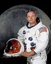
Neil Armstrong, first human to walk on the Moon (1969)

Yang Liwei, first person sent into space by China

The first human in space was Soviet Yuri Gagarin, who was launched on April 12, 1961 aboard Vostok 1 and orbited around the Earth for 108 minutes. The first woman in space was Soviet Valentina Tereshkova, who launched on June 16, 1963 aboard Vostok 6 and orbited Earth for almost three days.

Alan Shepard became the first American and second person in space on May 5, 1961 on a 15-minute sub-orbital flight. The first American woman in space was Sally Ride, during Space Shuttle Challenger's mission STS-7, on June 18, 1983.[26] In 1992 Mae Jemison became the first African American woman to travel in space aboard STS-47.

Cosmonaut Alexei Leonov was the first person to conduct an extravehicular activity (EVA), (commonly called a "spacewalk"), on March 18, 1965, on the Soviet Union's Voskhod 2 mission. This was followed two and a half months later by astronaut Ed White who made the first American EVA on NASA's Gemini 4 mission.[27]

The first manned mission to orbit the Moon, Apollo 8, included American William Anders who was born in Hong Kong, making him the first Asian-born astronaut in 1968.

The Soviet Union, through its Intercosmos program, allowed people from other "socialist" (i.e. Warsaw Pact and other Soviet-allied) countries to fly on its missions, with the notable exception of France participating in Soyuz TM-7. An example is Czechoslovak Vladimír Remek, the first cosmonaut from a country other than the Soviet Union or the United States, who flew to space in 1978 on a Soyuz-U rocket.[28]

On July 23, 1980, Pham Tuan of Vietnam became the first Asian in space when he flew aboard Soyuz 37.[29] Also in 1980, Cuban Arnaldo Tamayo Méndez became the first person of Hispanic and black African descent to fly in space, and in 1983, Guion Bluford became the first African American to fly into space. In April 1985, Taylor Wang became the first ethnic Chinese person in space.[30][31] The first person born in Africa to fly in space was Patrick Baudry (France), in 1985.[32][33] In 1985, Saudi Arabian Prince Sultan Bin Salman Bin AbdulAziz Al-Saud became the first Arab Muslim astronaut in space.[34] In 1988, Abdul Ahad Mohmand became the first Afghan to reach space, spending nine days aboard the Mir space station.[35]

With the larger number of seats available on the Space Shuttle, the U.S. began taking international astronauts. In 1983, Ulf Merbold of West Germany became the first non-US citizen to fly in a US spacecraft. In 1984, Marc Garneau became the first of 8 Canadian astronauts to fly in space (through 2010).[36] In 1985, Rodolfo Neri Vela became the first Mexican-born person in space.[37] In 1991, Helen Sharman became the first Briton to fly in space.[38] In 2002, Mark Shuttleworth became the first citizen of an African country to fly in space, as a paying spaceflight participant.[39] In 2003, Ilan Ramon became the first Israeli to fly in space, although he died during a re-entry accident.

On October 15, 2003, Yang Liwei became China's first astronaut on the Shenzhou 5 spacecraft.

Age milestones

The youngest person to fly in space is Gherman Titov, who was 25 years old when he flew Vostok 2. (Titov was also the first person to suffer space sickness).[40][41] The oldest person who has flown in space is John Glenn, who was 77 when he flew on STS-95.[42]

Duration and distance milestones

The longest stay in space thus far has been 438 days, by Russian Valeri Polyakov.[8] As of 2006, the most spaceflights by an individual astronaut is seven, a record held by both Jerry L. Ross and Franklin Chang-Diaz. The farthest distance from Earth an astronaut has traveled was 401,056 km (249,205 mi), when Jim Lovell, Jack Swigert, and Fred Haise went around the Moon during the Apollo 13 emergency.[8]

Civilian and non-government milestones

Depending on the exact definition of 'civilian', the first civilian in space was either Valentina Tereshkova[43] aboard Vostok 6 (she also became the first woman in space on that mission) or Joseph Albert Walker[44][45] on X-15 Flight 90 a month later. Tereshkova was only honorarily inducted into the USSR's Air Force, which had no female pilots whatsoever at that time. Joe Walker had joined the US Army Air Force but was not a member during his flight. The first people in space who had never been a member of any country's armed forces were both Konstantin Feoktistov and Boris Yegorov aboard Voskhod 1.

The first non-governmental space traveler was Byron K. Lichtenberg, a researcher from the Massachusetts Institute of Technology who flew on STS-9 in 1983.[46] In December 1990, Toyohiro Akiyama became the first paying space traveler as a reporter for Tokyo Broadcasting System, a visit to Mir as part of an estimated $12 million (USD) deal with a Japanese TV station, although at the time, the term used to refer to Akiyama was "Research Cosmonaut".[47][48][49] Akiyama suffered severe space sickness during his mission, which affected his productivity.[48]

The first self-funded space tourist was Dennis Tito on board the Russian spacecraft Soyuz TM-3 on April 28, 2001.

Self-funded travelers

The first person to fly on an entirely privately funded mission was Mike Melvill, piloting SpaceShipOne flight 15P on a suborbital journey, although he was a test pilot employed by Scaled Composites and not an actual paying space tourist.[50][51] Seven others have paid to Russian Space Agency to fly into space:
  1. Dennis Tito (American): April 28 – May 6, 2001 (ISS)
  2. Mark Shuttleworth (South African): April 25 – May 5, 2002 (ISS)
  3. Gregory Olsen (American): October 1–11, 2005 (ISS)
  4. Anousheh Ansari (Iranian / American): September 18–29, 2006 (ISS)
  5. Charles Simonyi (Hungarian / American): April 7–21, 2007 (ISS), March 26 – April 8, 2009 (ISS)
  6. Richard Garriott (British / American): October 12–24, 2008 (ISS)
  7. Guy Laliberté (Canadian): September 30, 2009 – October 11, 2009 (ISS)

Training


Elliot See during water egress training with NASA

The first NASA astronauts were selected for training in 1959.[52] Early in the space program, military jet test piloting and engineering training were often cited as prerequisites for selection as an astronaut at NASA, although neither John Glenn nor Scott Carpenter (of the Mercury Seven) had any university degree, in engineering or any other discipline at the time of their selection. Selection was initially limited to military pilots.[53][54] The earliest astronauts for both America and the USSR tended to be jet fighter pilots, and were often test pilots.
Once selected, NASA astronauts go through twenty months of training in a variety of areas, including training for extravehicular activity in a facility such as NASA's Neutral Buoyancy Laboratory.[1][53] Astronauts-in-training may also experience short periods of weightlessness in aircraft called the "vomit comet", the nickname given to a pair of modified KC-135s (retired in 2000 and 2004 respectively, and replaced in 2005 with a C-9) which perform parabolic flights.[52] Astronauts are also required to accumulate a number of flight hours in high-performance jet aircraft. This is mostly done in T-38 jet aircraft out of Ellington Field, due to its proximity to the Johnson Space Center. Ellington Field is also where the Shuttle Training Aircraft is maintained and developed, although most flights of the aircraft are done out of Edwards Air Force Base.

NASA candidacy requirements

  • Be citizens of the United States.[52][55]
  • Pass a strict physical examination, and have a near and distant visual acuity correctable to 20/20 (6/6). Blood pressure, while sitting, must be no greater than 140 over 90.

Commander and Pilot

  • A bachelor's degree in engineering, biological science, physical science or mathematics is required.
  • At least 1,000 hours' flying time as pilot-in-command in jet aircraft. Experience as a test pilot is desirable.
  • Height must be 5 ft 2 in to 6 ft 2 in (1.58 to 1.88 m).
  • Distant visual acuity must be correctable to 20/20 in each eye.
  • The refractive surgical procedures of the eye, PRK (Photorefractive keratectomy) and LASIK, are now allowed, providing at least 1 year has passed since the date of the procedure with no permanent adverse after effects. For those applicants under final consideration, an operative report on the surgical procedure will be requested.

Mission Specialist

  • A bachelor's degree in engineering, biological science, physical science or mathematics, as well as at least three years of related professional experience (graduate work or studies) and an advanced degree, such as a master's degree (one to three years) or a doctoral degree (three years or more).
  • Applicant's height must be between 4 ft. 10.5 in. and 6 ft. 4 in.

Mission Specialist Educator

  • Applicants must have a bachelor's degree with teaching experience, including work at the kindergarten through twelfth grade level. An advanced degree, such as a master's degree or a doctoral degree, is not required, but is strongly desired.[56]
Mission Specialist Educators, or "Educator Astronauts", were first selected in 2004, and as of 2007, there are three NASA Educator astronauts: Joseph M. Acaba, Richard R. Arnold, and Dorothy Metcalf-Lindenburger.[57][58] Barbara Morgan, selected as back-up teacher to Christa McAuliffe in 1985, is considered to be the first Educator astronaut by the media, but she trained as a mission specialist.[59] The Educator Astronaut program is a successor to the Teacher in Space program from the 1980s.[60][61]

Health risks of space travel

Astronauts are susceptible to a variety of health risks including decompression sickness, barotrauma, immunodeficiencies, loss of bone and muscle, loss of eyesight, orthostatic intolerance, sleep disturbances, and radiation injury.[62][63][64][65][66][67][68][69][70] A variety of large scale medical studies are being conducted in space via the National Space and Biomedical Research Institute (NSBRI) to address these issues. Prominent among these is the Advanced Diagnostic Ultrasound in Microgravity Study in which astronauts (including former ISS commanders Leroy Chiao and Gennady Padalka) perform ultrasound scans under the guidance of remote experts to diagnose and potentially treat hundreds of medical conditions in space. This study's techniques are now being applied to cover professional and Olympic sports injuries as well as ultrasound performed by non-expert operators in medical and high school students. It is anticipated that remote guided ultrasound will have application on Earth in emergency and rural care situations, where access to a trained physician is often rare.[71][72][73]
On December 31, 2012, a NASA-supported study reported that manned spaceflight may harm the brain and accelerate the onset of Alzheimer's disease.[74][75][76]

Food and drink

An astronaut on the International Space Station requires about 0.83 kilograms (1.83 pounds) weight of food inclusive of food packaging per meal each day. (The packaging for each meal weighs around 0.12 kilograms - 0.27 pounds) Longer-duration missions require more food.
Shuttle astronauts worked with nutritionists to select menus that appeal to their individual tastes. Five months before flight, menus are selected and analyzed for nutritional content by the shuttle dietician. Foods are tested to see how they will react in a reduced gravity environment. Caloric requirements are determined using a basal energy expenditure (BEE) formula. On Earth, the average American uses about 35 gallons (132 liters) of water every day. On board the ISS astronauts limit water use to only about three gallons (11 liters) per day.[77]

Insignia

In Russia, cosmonauts are awarded Pilot-Cosmonaut of the Russian Federation upon completion of their missions, often accompanied with the award of Hero of the Russian Federation. This follows the practice established in the USSR where cosmonauts were usually awarded the title Hero of the Soviet Union.

At NASA, those who complete astronaut candidate training receive a silver lapel pin. Once they have flown in space, they receive a gold pin. U.S. astronauts who also have active-duty military status receive a special qualification badge, known as the Astronaut Badge, after participation on a spaceflight. The United States Air Force also presents an Astronaut Badge to its pilots who exceed 50 miles (80 km) in altitude.

Space Mirror Memorial

Deaths

Eighteen astronauts (fourteen men and four women) have lost their lives during four space flights. By nationality, thirteen were American (including one of Indian origin), four were Russian (Soviet Union), and one was Israeli.Eleven people (all men) have lost their lives training for spaceflight: eight Americans and three Russians. Six of these were in crashes of training jet aircraft, one drowned during water recovery training, and four were due to fires in pure oxygen environments.

The Space Mirror Memorial, which stands on the grounds of the John F. Kennedy Space Center Visitor Complex, commemorates the lives of the men and women who have died during spaceflight and during training in the space programs of the United States. In addition to twenty NASA career astronauts, the memorial includes the names of a U.S. Air Force X-15 test pilot, a U.S. Air Force officer who died while training for a then-classified military space program, and a civilian spaceflight participant.

Mandatory Palestine

From Wikipedia, the free encyclopedia https://en.wikipedia.org/wiki/Mandatory_Palestine   Palestine 1920–...