Search This Blog

Friday, September 18, 2020

Bright green environmentalism

From Wikipedia, the free encyclopedia

Bright green environmentalism is an ideology based on the belief that the convergence of technological change and social innovation provides the most successful path to sustainable development.

Origin and evolution of bright green thinking

The term bright green, coined in 2003 by writer Alex Steffen, refers to the fast-growing new wing of environmentalism, distinct from traditional forms. Bright green environmentalism aims to provide prosperity in an ecologically sustainable way through the use of new technologies and improved design.

Proponents promote and advocate for green energy, electric automobiles, efficient manufacturing systems, bio and nanotechnologies, ubiquitous computing, dense urban settlements, closed loop materials cycles and sustainable product designs. One-planet living is a commonly used phrase. Their principal focus is on the idea that through a combination of well-built communities, new technologies and sustainable living practices, quality of life can actually be improved even while ecological footprints shrink.

Around the middle of the century we’ll see global population peak at something like 9 billion people, all of whom will want to live with a reasonable amount of prosperity, and many of whom will want, at the very least, a European lifestyle. They will see escaping poverty as their nonnegotiable right, but to deliver that prosperity at our current levels of efficiency and resource use would destroy the planet many times over. We need to invent a new model of prosperity, one that lets billions have the comfort, security, and opportunities they want at the level of impact the planet can afford. We can’t do that without embracing technology and better design.

The term bright green has been used with increased frequency due to the promulgation of these ideas through the Internet and recent coverage in the traditional media.

Dark greens, light greens and bright greens

Alex Steffen describes contemporary environmentalists as being split into three groups, dark, light, and bright greens.

Colors of the Greens

Light greens see protecting the environment first and foremost as a personal responsibility. They fall in on the transformational activist end of the spectrum, but light greens do not emphasize environmentalism as a distinct political ideology, or even seek fundamental political reform. Instead they often focus on environmentalism as a lifestyle choice. The motto "Green is the new black" sums up this way of thinking, for many. This is different from the term lite green, which some environmentalists use to describe products or practices they believe are greenwashing.

In contrast, dark greens believe that environmental problems are an inherent part of industrialized civilization, and seek radical political change. Dark greens believe that currently and historically dominant political ideologies (sometimes referred to as industrialism) inevitably lead to consumerism, overconsumption, waste, alienation from nature and resource depletion. Dark greens claim this is caused by the emphasis on economic growth that exists within all existing ideologies, a tendency referred to as growth mania. The dark green brand of environmentalism is associated with ideas of ecocentrism, deep ecology, degrowth, anti-consumerism, post-materialism, holism, the Gaia hypothesis of James Lovelock, as well as support for a reduction in human numbers and/or a relinquishment of technology to reduce humanity's effect on the biosphere.

More recently, bright greens emerged as a group of environmentalists who believe that radical changes are needed in the economic and political operation of society in order to make it sustainable, but that better designs, new technologies and more widely distributed social innovations are the means to make those changes—and that society can neither stop nor protest its way to sustainability. As Ross Robertson writes,

[B]right green environmentalism is less about the problems and limitations we need to overcome than the "tools, models, and ideas" that already exist for overcoming them. It forgoes the bleakness of protest and dissent for the energizing confidence of constructive solutions.

International perspective

While bright green environmentalism is an intellectual current among North American environmentalists (with a number of businesses, blogs, NGOs and even governments now explicitly calling themselves bright green—for instance, the City of Vancouver's strategic planning document is called "Vancouver 2020: A Bright Green Future"), it is in Northern Europe, especially Scandinavia, Germany, the Netherlands and the United Kingdom, that the idea of bright green environmentalism has become most widespread and most widely discussed. For instance, the official technology showcase and business expo for the United Nations Framework Convention on Climate Change in Copenhagen is called Bright Green in reference to this idea, while the Danish youth climate activism movement is called Bright Green Youth.

Pale Blue Dot

From Wikipedia, the free encyclopedia
 
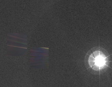
Dark grey and black static with coloured vertical rays of sunlight over part of the image. A small pale blue point of light is barely visible.
Seen from about 6 billion kilometers (3.7 billion miles), Earth appears as a tiny dot within deep space: the blueish-white speck almost halfway up the brown band on the right.

Pale Blue Dot is a photograph of planet Earth taken on February 14, 1990, by the Voyager 1 space probe from a record distance of about 6 billion kilometers (3.7 billion miles, 40.5 AU), as part of that day's Family Portrait series of images of the Solar System.

In the photograph, Earth's apparent size is less than a pixel; the planet appears as a tiny dot against the vastness of space, among bands of sunlight reflected by the camera.

Voyager 1, which had completed its primary mission and was leaving the Solar System, was commanded by NASA to turn its camera around and take one last photograph of Earth across a great expanse of space, at the request of astronomer and author Carl Sagan. The phrase "Pale Blue Dot" was coined by Sagan himself in his reflections on the photograph's significance, documented in his 1994 book of the same name.

Background

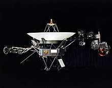
In September 1977, NASA launched Voyager 1, a 722-kilogram (1,592 lb) robotic spacecraft on a mission to study the outer Solar System and eventually interstellar space. After the encounter with the Jovian system in 1979 and the Saturnian system in 1980, the primary mission was declared complete in November of the same year. Voyager 1 was the first space probe to provide detailed images of the two largest planets and their major moons.

A space probe resting on a stand, with a parabolic antenna pointing upwards and two arms extending from the sides, bearing cameras and other devices, against a black background curtain
The Voyager 1 spacecraft

The spacecraft, still travelling at 64,000 km/h (40,000 mph), is the most distant human-made object from Earth and the first one to leave the Solar System. Its mission has been extended and continues to this day, with the aim of investigating the boundaries of the Solar System, including the Kuiper belt, the heliosphere and interstellar space. Operating for 43 years and 12 days as of today (17 September 2020), it receives routine commands and transmits data back to the Deep Space Network.

Voyager 1 was expected to work only through the Saturn encounter. When the spacecraft passed the planet in 1980, Sagan proposed the idea of the space probe taking one last picture of Earth. He acknowledged that such a picture would not have had much scientific value, as the Earth would appear too small for Voyager's cameras to make out any detail, but it would be meaningful as a perspective on humanity's place in the universe.

Although many in NASA's Voyager program were supportive of the idea, there were concerns that taking a picture of Earth so close to the Sun risked damaging the spacecraft's imaging system irreparably. It was not until 1989 that Sagan's idea was put into practice, but then instrument calibrations delayed the operation further, and the personnel who devised and transmitted the radio commands to Voyager 1 were also being laid off or transferred to other projects. Finally, NASA Administrator Richard Truly interceded to ensure that the photograph was taken. A proposal to continue to photograph Earth as it orbited the Sun was rejected.

Camera

Voyager 1's Imaging Science Subsystem (ISS) consists of two cameras: a 200 mm focal length, low-resolution wide-angle camera (WA), used for spatially extended imaging, and a 1500 mm high-resolution narrow-angle camera (NA) – the one that took Pale Blue Dot – intended for detailed imaging of specific targets. Both cameras are of the slow-scan vidicon tube type and were fitted with eight colored filters, mounted on a filter wheel placed in front of the tube.

The challenge was that, as the mission progressed, the objects to be photographed would increasingly be farther away and would appear fainter, requiring longer exposures and slewing (panning) of the cameras to achieve acceptable quality. The telecommunication capability also diminished with distance, limiting the number of data modes that could be used by the imaging system.

After taking the Family Portrait series of images, which included Pale Blue Dot, NASA mission managers commanded Voyager 1 to power its cameras down, as the spacecraft was not going to fly near anything else of significance for the rest of its mission, while other instruments that were still collecting data needed power for the long journey to interstellar space.

Photograph

The design of the command sequence to be relayed to the spacecraft and the calculations for each photograph's exposure time were developed by space scientists Candy Hansen of NASA's Jet Propulsion Laboratory and Carolyn Porco of the University of Arizona. The command sequence was then compiled and sent to Voyager 1, with the images taken at 04:48 GMT on February 14, 1990.

The data from the camera was stored initially in an on-board tape recorder. Transmission to Earth was also delayed by the Magellan and Galileo missions being given priority over the use of the Deep Space Network. Then, between March and May 1990, Voyager 1 returned 60 frames back to Earth, with the radio signal travelling at the speed of light for nearly five and a half hours to cover the distance.

Three of the frames received showed the Earth as a tiny point of light in empty space. Each frame had been taken using a different color filter: blue, green and violet, with exposure times of 0.72, 0.48 and 0.72 seconds respectively. The three frames were then recombined to produce the image that became Pale Blue Dot.

The wide-angle photograph of the Sun and inner planets (not visible), with Pale Blue Dot superimposed on the left, Venus to its right

Of the 640,000 individual pixels that compose each frame, Earth takes up less than one (0.12 of a pixel, according to NASA). The light bands across the photograph are an artifact, the result of sunlight reflecting off parts of the camera and its sunshade, due to the relative proximity between the Sun and the Earth. Voyager's point of view was approximately 32° above the ecliptic. Detailed analysis suggested that the camera also detected the Moon, although it is too faint to be visible without special processing.

Pale Blue Dot, which was taken with the narrow-angle camera, was also published as part of a composite picture created from a wide-angle camera photograph showing the Sun and the region of space containing the Earth and Venus. The wide-angle image was inset with two narrow-angle pictures: Pale Blue Dot and a similar photograph of Venus. The wide-angle photograph was taken with the darkest filter (a methane absorption band) and the shortest possible exposure (5 milliseconds), to avoid saturating the camera's vidicon tube with scattered sunlight. Even so, the result was a bright burned-out image with multiple reflections from the optics in the camera and the Sun that appears far larger than the actual dimension of the solar disk. The rays around the Sun are a diffraction pattern of the calibration lamp which is mounted in front of the wide-angle lens.

Pale blue color

Earth appears as a blue dot in the photograph primarily because of Rayleigh scattering of sunlight in its atmosphere. In Earth's air, short-wavelength visible light such as blue light is scattered to a greater extent than longer wavelength light such as red light, which is the reason why the sky appears blue from Earth. (The ocean also contributes to Earth's blueness, but to a lesser degree than scattering.) Earth is a pale blue dot, rather than dark blue, because white light reflected by clouds combines with the scattered blue light.

Earth's reflectance spectrum from the far-ultraviolet to the near-infrared is unlike that of any other observed planet and is partially due to the presence of life on Earth. Rayleigh scattering, which causes Earth's blueness, is enhanced in an atmosphere that does not substantially absorb visible light, unlike, for example, the orange-brown color of Titan, where organic haze particles absorb strongly at blue visible wavelengths. Earth's plentiful atmospheric oxygen, which is produced by photosynthetic life forms, causes the atmosphere to be transparent to visible light, which allows for substantial Rayleigh scattering and hence stronger reflectance of blue light.

Distance

Position of Voyager 1 on February 14, 1990. The vertical bars are spaced one year apart and indicate the probe's distance above the ecliptic.

According to NASA's Jet Propulsion Laboratory's HORIZONS tool, the distances between Voyager 1 and the Earth on February 14 and May 15, 1990, were as follows:

Distance of Voyager 1 from Earth
Unit of measurement February 14, 1990 May 15, 1990
Astronomical units 40.472229 40.417506
Kilometers 6,054,587,000 6,046,400,000
Miles 3,762,146,000 3,757,059,000

Reflections

In his 1994 book, Pale Blue Dot, Carl Sagan comments on what he sees as the greater significance of the photograph, writing:

Look again at that dot. That's here. That's home. That's us. On it, everyone you love, everyone you know, everyone you ever heard of, every human being who ever was, lived out their lives. The aggregate of our joy and suffering, thousands of confident religions, ideologies, and economic doctrines, every hunter and forager, every hero and coward, every creator and destroyer of civilization, every king and peasant, every young couple in love, every mother and father, hopeful child, inventor and explorer, every teacher of morals, every corrupt politician, every "superstar," every "supreme leader," every saint and sinner in the history of our species lived there--on a mote of dust suspended in a sunbeam.

The Earth is a very small stage in a vast cosmic arena. Think of the rivers of blood spilled by all those generals and emperors so that, in glory and triumph, they could become the momentary masters of a fraction of a dot. Think of the endless cruelties visited by the inhabitants of one corner of this pixel on the scarcely distinguishable inhabitants of some other corner, how frequent their misunderstandings, how eager they are to kill one another, how fervent their hatreds.

Our posturings, our imagined self-importance, the delusion that we have some privileged position in the Universe, are challenged by this point of pale light. Our planet is a lonely speck in the great enveloping cosmic dark. In our obscurity, in all this vastness, there is no hint that help will come from elsewhere to save us from ourselves.

The Earth is the only world known so far to harbor life. There is nowhere else, at least in the near future, to which our species could migrate. Visit, yes. Settle, not yet. Like it or not, for the moment the Earth is where we make our stand.

It has been said that astronomy is a humbling and character-building experience. There is perhaps no better demonstration of the folly of human conceits than this distant image of our tiny world. To me, it underscores our responsibility to deal more kindly with one another, and to preserve and cherish the pale blue dot, the only home we've ever known.

— Carl Sagan

Anniversaries

Pale Blue Dot Revisited, 2020

In 2015, NASA acknowledged the 25th anniversary of the photograph. Ed Stone, Voyager project scientist, commented: "Twenty-five years ago, Voyager 1 looked back toward Earth and saw a "pale blue dot", an image that continues to inspire wonderment about the spot we call home."

In 2020, for the image's 30th anniversary, NASA published a new version of the original Voyager photo: Pale Blue Dot Revisited, obtained using modern image processing techniques "while attempting to respect the original data and intent of those who planned the images." Brightness levels and colors were rebalanced to enhance the area containing the Earth, and the image was enlarged, appearing brighter and less grainy than the original. The direction of the Sun is toward the bottom, where the image is brightest.

To celebrate the same occasion, the Carl Sagan Institute released a video with several noted astronomers reciting Sagan's "Pale Blue Dot" speech.

Earthrise

From Wikipedia, the free encyclopedia
 
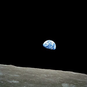
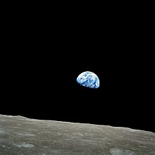
Earthrise, taken on December 24, 1968, by Apollo 8 astronaut William Anders.
 
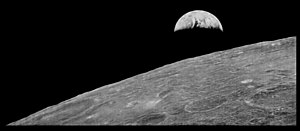
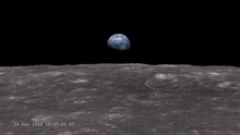
The first photograph of Earth from the Moon taken by Lunar Orbiter 1 in 1966, reprocessed by the LOIRP for comparison.

Earthrise is a photograph of Earth and some of the Moon's surface that was taken from lunar orbit by astronaut William Anders on December 24, 1968, during the Apollo 8 mission. Nature photographer Galen Rowell declared it "the most influential environmental photograph ever taken".

Anders' color image had been preceded by a crude black-and-white 1966 raster image taken by the Lunar Orbiter 1 robotic probe, the first American spacecraft to orbit the Moon.

Details

Menu
0:00
The conversation between Frank Borman, Jim Lovell and William Anders, during the taking of the Earthrise photograph

Earthrise is the name popularly given to NASA image AS08-14-2383, taken by astronaut William Anders during the Apollo 8 mission, the first crewed voyage to orbit the Moon.

Initially, before Anders found a suitable 70 mm color film, mission commander Frank Borman said he took a black-and-white photograph of the scene, with the Earth's terminator touching the horizon (AS08-13-2329). The land mass position and cloud patterns in this image are the same as those of the color photograph entitled Earthrise.

The photograph was taken from lunar orbit on December 24, 1968, 16:00 UTC, with a highly modified Hasselblad 500 EL with an electric drive. The camera had a simple sighting ring rather than the standard reflex viewfinder and was loaded with a 70 mm film magazine containing custom Ektachrome film developed by Kodak. Immediately prior, Anders had been photographing the lunar surface with a 250 mm lens; the lens was subsequently used for the Earthrise images. An audio recording of the event is available with transcription which allows the event to be followed closely – excerpt:

Anders: Oh my God! Look at that picture over there! There's the Earth coming up. Wow, that's pretty.
Borman: Hey, don't take that, it's not scheduled. (joking)
Anders: (laughs) You got a color film, Jim?
            Hand me that roll of color quick, would you...
Lovell: Oh man, that's great!

There were many images taken at that point. The mission audio tape establishes several photographs were taken, on Borman's orders, with the enthusiastic concurrence of Jim Lovell and Anders. Anders took the first color shot, then Lovell who notes the setting (1/250th of a second at f/11), followed by Anders with another very similar shot (AS08-14-2384).

A nearly full-page black and white reproduction of Borman's image may be viewed on page 164 of his 1988 autobiography, captioned, "One of the most famous pictures in photographic history – taken after I grabbed the camera away from Bill Anders". Borman was the mission commander and notes that this is the image "the Postal Service used on a stamp, and few photographs have been more frequently reproduced". The photograph reproduced in the Frank Borman autobiography is not the same image as the Anders photograph; aside from the orientation, the cloud patterns differ. Borman later recanted this story and agreed that the black and white shot was also taken by Anders, based on evidence presented by transcript and a video produced by NASA Goddard Space Flight Center Scientific Visualization Studio employee, Ernie Wright.

The stamp issue reproduces the cloud, color, and crater patterns of the Anders picture. Anders is described by Borman as holding "a masters degree in nuclear engineering"; Anders was thus tasked as "the scientific crew member ... also performing the photography duties that would be so important to the Apollo crew who actually landed on the Moon".

On the 50th anniversary of the Apollo 8 mission in 2018, Anders described in an interview how the image undermined his religious belief: "It really undercut my religious beliefs. The idea that things rotate around the pope and up there is a big supercomputer wondering whether Billy was a good boy yesterday? It doesn't make any sense. I became a big buddy of [atheist scientist] Richard Dawkins."

Geometry

AS08-14-2383 (21713574299), from which "Earthrise" was cropped. The photo is displayed here in its original orientation.

William Anders' first color Earthrise photo, in its orientation as seen by the crew of Apollo 8. Lunar north is up.

The as-taken image was rotated 90 degrees clockwise to produce the iconic published Earthrise orientation because the original image did not convey the sense of the Earth rising over the moonscape. The as-published photograph shows Earth:

  • Polar orientation: south to left, north to right (Antarctica at 10 o'clock)
  • Equator: centre, running westward toward top right-hand corner
  • Nightfall terminator crossing the African continent (lightish region to left is Namib Desert, Namibia; to right is Western Sahara/West Africa)
  • Rotated clockwise approximately 135° from our typical north–south-Pole-oriented perspective

Legacy

In Life's 100 Photographs that Changed the World, wilderness photographer Galen Rowell called Earthrise "the most influential environmental photograph ever taken". Another author called its appearance the beginning of the environmental movement. Fifty years to the day after taking the photo, William Anders observed, "We set out to explore the moon and instead discovered the Earth."

In October 2018, the Working Group for Planetary System Nomenclature (WGPSN) of the International Astronomical Union named two of the craters seen in the photo Anders' Earthrise and 8 Homeward. The craters had previously been designated only with letters.

Joni Mitchell sings on "Refuge of the Roads": In a highway service station / Over the month of June / Was a photograph of the Earth / Taken coming back from the Moon / And you couldn't see a city / On that marbled bowling ball / Or a forest or a highway / Or me here least of all …

Stamp

In 1969, the U.S. Postal Service issued a stamp (Scott# 1371) commemorating the Apollo 8 flight around the Moon. The stamp featured a detail (in color) of the Earthrise photograph, and the words, "In the beginning God...", recalling the Apollo 8 Genesis reading.[20]

2008 video

On April 6, 2008 (Japan Standard Time), the first 1080p high-definition Earthrise video was captured, both a full Earthrise and Earthset video, by the JAXA lunar orbiter mission, SELENE (better known in Japan by its nickname Kaguya). After successfully orbiting the Moon for 1 year and 8 months, it was crashed intentionally onto the lunar surface at 18:25 UTC on June 10, 2009.

2013 simulation video

A simulation of what the Apollo 8 crew saw as the Earth rose above the lunar horizon during their fourth orbit around the Moon that pauses to overlay two photographs taken by the crew and includes a clock overlay

In 2013, in commemoration of the 45th anniversary of the Apollo 8 mission, NASA issued a video about the taking of the photograph. This computer-generated visualization used data from the Lunar Reconnaissance Orbiter spacecraft, which had provided detailed images of the lunar surface that could be matched with those taken every 20 seconds by an automatic camera on Apollo 8. The resulting video, re-creating what the astronauts would have seen (rotated 90 degrees clockwise to match the perspective presented in the photograph), was synchronized with the recording of the crew's conversation as they became the first humans to witness an Earthrise. The video included explanatory narration written and read by Andrew Chaikin. Chaikin writes that all the photographs of the rising Earth on Apollo 8's fourth orbit were taken by Anders.

Potential earthrises as seen from the Moon's surface

The Earth straddling the limb of the Moon, as seen from above Compton crater. Taken by the Lunar Reconnaissance Orbiter in 2015.

The Earth "rose" because the spacecraft was traveling over the Moon's surface. An earthrise that might be witnessed from the surface of the Moon would be quite unlike moonrises on Earth. Because the Moon is tidally locked with the Earth, one side of the Moon always faces toward Earth. Interpretation of this fact would lead one to believe that the Earth's position is fixed on the lunar sky and no earthrises can occur; however, the Moon librates slightly, which causes the Earth to draw a Lissajous figure on the sky. This figure fits inside a rectangle 15°48' wide and 13°20' high (in angular dimensions), while the angular diameter of the Earth as seen from Moon is only about 2°. This means that earthrises are visible near the edge of the Earth-observable surface of the Moon (about 20% of the surface). Since a full libration cycle takes about 27 days, earthrises are very slow, and it takes about 48 hours for Earth to clear its diameter. During the course of the month-long lunar orbit, an observer would additionally witness a succession of "Earth phases", much like the lunar phases seen from Earth. That is what accounts for the half-illuminated globe, the ashen glow, seen in the photograph.

The Blue Marble

From Wikipedia, the free encyclopedia
 
The Blue Marble by the crew of Apollo 17 (1972)

The Blue Marble is an image of Earth taken on December 7, 1972, from a distance of about 29,000 kilometers (18,000 miles) from the planet's surface. It was taken by the crew of the Apollo 17 spacecraft on its way to the Moon, and is one of the most reproduced images in history.

It mainly shows the Earth from the Mediterranean Sea to Antarctica. This was the first time the Apollo trajectory made it possible to photograph the south polar ice cap, despite the Southern Hemisphere being heavily covered in clouds. In addition to the Arabian Peninsula and Madagascar, almost the entire coastline of Africa is clearly visible. The Asian mainland is on the horizon.

NASA has also applied the name to a 2012 series of images which cover the entire globe at relatively high resolution. These were created by looking through satellite pictures taken over time in order to find as many cloudless photographs as possible to use in the final images.

The photograph

The photograph, taken on December 7, 1972, at 05:39 a.m. EST (10:39 UTC), is one of the most widely distributed photographic images in existence. The image is one of the few to show an almost fully illuminated Earth as the astronauts had the Sun behind them when they took the image. To the astronauts, the slightly gibbous Earth had the appearance and size of a glass marble, hence the name. It has been mostly shown with Antarctica at the bottom, although the actual view the astronauts had was with Antarctica on top.

History

AS17-148-22727, from which The Blue Marble was cropped. The photograph's original orientation had south pointed up.

The photograph was taken about 5 hours 6 minutes after launch of the Apollo 17 mission, and about 1 hour 54 minutes after the spacecraft left its parking orbit around Earth, to begin its trajectory to the Moon. The time of Apollo 17's launch, 12:33 a.m. EST, meant that Africa was in daylight during the early hours of the spacecraft's flight. With the December solstice approaching, Antarctica was also illuminated.

The 1972 Tamil Nadu cyclone can be seen in the bottom left of the image. This storm had brought flooding and high winds to the Indian state of Tamil Nadu on December 5, two days before the photograph was taken.

The photograph's official NASA designation is AS17-148-22727. NASA photograph AS17-148-22726, taken just before and nearly identical to 22727, is also used as a full-Earth image. The widely published versions are cropped and chromatically adjusted from the original photographs.

The photographer used a 70-millimeter Hasselblad camera with an 80-millimeter Zeiss lens. NASA credits the image to the entire Apollo 17 crew—Gene Cernan, Ronald Evans and Harrison Schmitt—all of whom took photographs during the mission with the on-board Hasselblad, although evidence examined after the mission suggests that Schmitt was the photographer.

All Apollo flights were heavily scheduled down to the minute. At the time this photo was taken, none of the astronauts was scheduled to do so. Thus this photo was taken quickly in a stolen moment. The astronaut who took the picture was weightless, and the continents were hard to see, and he took the photo quickly, which explains the photo’s orientation, compared to the north up orientation of most maps.

Apollo 17 was the last crewed lunar mission. No human since has been far enough from Earth to photograph a whole-Earth image such as The Blue Marble, but whole-Earth images have been taken by many uncrewed spacecraft missions.

The Blue Marble was not the first clear image taken of an illuminated face of Earth, since similar shots from the ATS-3 satellite had already been made as early as 1967. The Apollo 17 image, however, released during a surge in environmental activism during the 1970s, became a symbol of the environmental movement, as a depiction of Earth's frailty, vulnerability, and isolation amid the vast expanse of space. NASA archivist Mike Gentry has speculated that The Blue Marble is among the most widely distributed images in history.

Subsequent Blue Marble images

Subsequent similar images of Earth (including composites at much higher resolution) have also been termed Blue Marble images, and the phrase "blue marble" (as well as the picture itself) is frequently used, as in the Earth flag by environmental activist organizations or companies attempting to promote an environmentally conscious image. There has also been a children's television program called Big Blue Marble. Poet-diplomat Abhay Kumar penned an Earth anthem inspired by the Blue Marble which contains "all the peoples and the nations of the world, one for all, all for one, united we unfurl the blue marble flag".

Imaging series 2001–2004

Blue Marble composite images generated by NASA in 2001 and 2002.
 
NASA Earth Observatory animation of Blue Marble Next Generation (2004).

In 2002, NASA released an extensive set of satellite-captured imagery, including prepared images suitable for direct human viewing, as well as complete sets suitable for use in preparing further works. At the time, 1 km/pixel was the most detailed imagery available for free, and permitted for reuse without a need for extensive preparatory work to eliminate cloud cover and conceal missing data, or to parse specialized data formats. The data also included a similarly manually assembled cloud-cover and night-lights image sets, at lower resolutions.

A subsequent release was made in 2005, named Blue Marble Next Generation. This series of photo mosaics was produced with the aid of automated image-sifting upon images from NASA's Earth Observatory, which enabled the inclusion of a complete, cloud-free globe for each month from January to December 2004, at even higher resolution (500 m/pixel). The original release of a single-image set covering the entire globe could not reflect the extent of seasonal snow-and-vegetative cover across both hemispheres, but this newer release closely modeled the changes of the seasons.

A number of interactive viewers for these data have also been released, among them a music visualization for the PlayStation 3 that is based on the texture data.

Blue Marble 2012

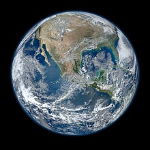
Blue Marble 2012 – a composite satellite image

On January 25, 2012, NASA released a composite image of the Western Hemisphere of Earth titled Blue Marble 2012. The picture logged over 3.1 million views on the Flickr image hosting website within the first week of release. On February 2, 2012, NASA released a companion to this new Blue Marble, showing a composite image of the Eastern Hemisphere from data obtained on January 23, 2012.

The picture is composed of data obtained by the Visible/Infrared Imager Radiometer Suite (VIIRS) instrument on board the Suomi NPP satellite on January 4, 2012. The data was obtained from six orbits of the Earth by the Suomi NPP over an eight-hour period. The image was created using a near-sided perspective projection with the viewing point placed 2100 km above 20° North by 100° West. This projection results in a very wide-angle presentation such as one might get with a fish-eye lens, and it does not include the whole hemisphere.

Black Marble 2012

Black Marble – North and South America at night, Hurricane Sandy can be seen off the coast of Florida.

On December 5, 2012, NASA released a nighttime view of Earth called Black Marble during an annual meeting of Earth scientists held by the American Geophysical Union in San Francisco. The images display all the human and natural matter that glows and can be detected from space. The data was acquired by the Suomi NPP satellite in April and October 2012 and then mapped over existing Blue Marble imagery of Earth to provide a realistic view of the planet. The Suomi NPP satellite completed 312 orbits and gathered 2.5 terabytes of data to get a clear shot of every parcel of the Earth's land surface. Named for satellite meteorology pioneer Verner Suomi, the satellite flies over any given point on Earth's surface twice each day and flies 512 miles (824 km) above the surface in a polar orbit.

The nighttime views were obtained with the new satellite's "day-night band" of the Visible Infrared Imaging Radiometer Suite (VIIRS), which detects light in a range of wavelengths from green to near-infrared, and uses filtering techniques to observe dim signals such as city lights, gas flares, auroras, wildfires, and reflected moonlight. Auroras, fires, and other stray light have been removed in the case of the Black Marble images to emphasize the city lights. The images have been used to study the spatial distribution of economic activity, to select sites for astronomical observatories, and to monitor human activities around protected areas.

DSCOVR

The Moon moving in front of Earth in July 2016, as seen by the DSCOVR satellite. The far side of the Moon faces the camera.

On July 21, 2015, NASA released a new Blue Marble photograph taken by a U.S. Deep Space Climate Observatory (DSCOVR), a solar weather and Earth observation satellite that was launched in February 2015 and will provide a near-continuous view of the entire sunlit-side of the Earth. The image was taken on July 6, 2015. The photograph, of the Western Hemisphere, is centered over Central America. The Western United States, Mexico and the Caribbean are visible, but much of South America is hidden beneath cloud cover. Greenland can be seen at the upper edge of the image.

The EPIC science team plans to upload 13 new color images per day on their website. The color balance has been adjusted to approximate an image that could be seen with the average human eye. In addition to images, scientific information will be uploaded as it becomes available after in-flight calibration is complete. The science information will be ozone and aerosol amounts, cloud reflectivity, cloud height, and vegetation information. The EPIC instrument views the Earth from sunrise in the west to sunset in the east 12 to 13 times per day as the Earth rotates at 15 degrees of longitude per hour. Clearly visible are storms forming over the Atlantic and Pacific Oceans, major slowly moving "cloud rivers", dust aerosol plumes from Africa, the sun's reflection in the oceans, ship exhaust tracks in the clouds, rivers and lakes, and the variegated land surface patterns especially in the African deserts. The spatial resolution of the color images is about 10 km, and the resolution of the science products will be about 20 km. Once every three months, lunar images are obtained that are the same as those viewed from Earth during our full Moon. On occasion, the other side of the Moon will appear in the Earth images as the Moon crosses in front of the Earth.

Stewart Brand

From Wikipedia, the free encyclopedia
 
Stewart Brand
Man at home in front of a full bookcase
Stewart Brand at his Sausalito office in 2020.
BornDecember 14, 1938 (age 81)
Rockford, Illinois, United States
OccupationWriter, editor, entrepreneur
Known forWhole Earth Catalog
The WELL
Long Now Foundation
Spouse(s)Lois Jennings (1966–1973)
Ryan Phelan (1983–present)
Websitesb.longnow.org

Stewart Brand (born December 14, 1938) is an American writer, best known as editor of the Whole Earth Catalog. He founded a number of organizations, including The WELL, the Global Business Network, and the Long Now Foundation. He is the author of several books, most recently Whole Earth Discipline: An Ecopragmatist Manifesto.

Life

Brand was born in Rockford, Illinois and attended Phillips Exeter Academy in New Hampshire. He studied biology at Stanford University, graduating in 1960. As a soldier in the U.S. Army, he was a parachutist and taught infantry skills; he later expressed the view that his experience in the military had fostered his competence in organizing. A civilian again in 1962, he studied design at San Francisco Art Institute, photography at San Francisco State College, and participated in a legitimate scientific study of then-legal LSD, in Menlo Park, California. In 1966, he married mathematician Lois Jennings, an Ottawa Native American.

Brand has lived in California since the 1960s. He and his second wife live on Mirene, a 64-foot (20 m)-long working tugboat. Built in 1912, the boat is moored in a former shipyard in Sausalito, California. He works in Mary Heartline, a grounded fishing boat about 100 yards (90 metres) away. One of his favorite items is a table on which Otis Redding is said to have written "(Sittin' On) The Dock of the Bay". (Brand acquired it from an antiques dealer in Sausalito.)

Merry Pranksters

By the mid-1960s, Brand became associated with author Ken Kesey and the "Merry Pranksters". With his partner Ramón Sender Barayón, he produced the Trips Festival in San Francisco, an early effort involving rock music and light shows. This was one of the first venues at which the Grateful Dead performed in San Francisco. About 10,000 hippies attended, and Haight-Ashbury soon emerged as a community. Tom Wolfe describes Brand in his 1968 book, The Electric Kool-Aid Acid Test.

NASA images of Earth

Earth from space, by ATS-3 satellite, 1967.
 

In 1966, while on an LSD trip on the roof of his house in North Beach, San Francisco, Brand became convinced that seeing an image of the whole Earth would change how we think about the planet and ourselves. He then campaigned to have NASA release the then-rumored satellite image of the entire Earth as seen from space. He sold and distributed buttons for 25 cents each asking, "Why haven't we seen a photograph of the whole Earth yet?". During this campaign, Brand met Richard Buckminster Fuller, who offered to help Brand with his projects. In 1967, a satellite, ATS-3, took the photo. Brand thought the image of our planet would be a powerful symbol. It adorned the first (Fall 1968) edition of the Whole Earth Catalog. Later in 1968, NASA astronaut Bill Anders took an Earth photo, Earthrise, from Moon orbit, which became the front image of the spring 1969 edition of the Catalog. 1970 saw the first celebration of Earth Day. During a 2003 interview, Brand explained that the image "gave the sense that Earth's an island, surrounded by a lot of inhospitable space. And it's so graphic, this little blue, white, green and brown jewel-like icon amongst a quite featureless black vacuum."

Douglas Engelbart

In late 1968, Brand assisted electrical engineer Douglas Engelbart with The Mother of All Demos, a famous presentation of many revolutionary computer technologies (including hypertext, email, and the mouse) to the Fall Joint Computer Conference in San Francisco.

Brand surmised that given the necessary consciousness, information, and tools, human beings could reshape the world they had made (and were making) for themselves into something environmentally and socially sustainable.

Whole Earth Catalog

During the late 1960s and early 1970s about 10 million Americans were involved in living communally. In 1968, using the most basic approaches to typesetting and page-layout, Brand and his colleagues created issue number one of The Whole Earth Catalog, employing the significant subtitle, "access to tools". Brand and his wife Lois travelled to communes in a 1963 Dodge truck known as the Whole Earth Truck Store, which moved to a storefront in Menlo Park, California. That first oversize Catalog, and its successors in the 1970s and later, reckoned a wide assortment of things could serve as useful "tools": books, maps, garden implements, specialized clothing, carpenters' and masons' tools, forestry gear, tents, welding equipment, professional journals, early synthesizers, and personal computers. Brand invited "reviews" (written in the form of a letter to a friend) of the best of these items from experts in specific fields. The information also described where these things could be located or purchased. The Catalog's publication coincided with the great wave of social and cultural experimentation, convention-breaking, and "do it yourself" attitude associated with the "counterculture".

The influence of these Whole Earth Catalogs on the rural back-to-the-land movement of the 1970s, and the communities movement within many cities, was widespread throughout the United States, Canada, and Australia. A 1972 edition sold 1.5 million copies, winning the first U.S. National Book Award in category Contemporary Affairs.

CoEvolution Quarterly

To continue this work and also to publish full-length articles on specific topics in the natural sciences and invention, in numerous areas of the arts and the social sciences, and on the contemporary scene in general, Brand founded the CoEvolution Quarterly (CQ) during 1974, aimed primarily at educated laypersons. Brand never better revealed his opinions and reason for hope than when he ran, in CoEvolution Quarterly #4, a transcription of technology historian Lewis Mumford's talk "The Next Transformation of Man", in which he stated that "man has still within him sufficient resources to alter the direction of modern civilization, for we then need no longer regard man as the passive victim of his own irreversible technological development."

The content of CoEvolution Quarterly often included futurism or risqué topics. Besides giving space to unknown writers with something valuable to say, Brand presented articles by many respected authors and thinkers, including Lewis Mumford, Howard T. Odum, Witold Rybczynski, Karl Hess, Orville Schell, Ivan Illich, Wendell Berry, Ursula K. Le Guin, Gregory Bateson, Amory Lovins, Hazel Henderson, Gary Snyder, Lynn Margulis, Eric Drexler, Gerard K. O'Neill, Peter Calthorpe, Sim Van der Ryn, Paul Hawken, John Todd, Kevin Kelly, and Donella Meadows. During ensuing years, Brand authored and edited a number of books on topics as diverse as computer-based media, the life history of buildings, and ideas about space colonies.

He founded the Whole Earth Software Review, a supplement to the Whole Earth Software Catalog, in 1984. It merged with CoEvolution Quarterly to form the Whole Earth Review in 1985.

California government

From 1977 to 1979, Brand served as "special adviser" to the administration of California Governor Jerry Brown.

The WELL

In 1985, Brand and Larry Brilliant founded The WELL ("Whole Earth 'Lectronic Link"), a prototypical, wide-ranging online community for intelligent, informed participants the world over. The WELL won the 1990 Best Online Publication Award from the Computer Press Association. Almost certainly the ideas behind the WELL were greatly inspired by Douglas Engelbart's work at SRI International; Brand was acknowledged by Engelbart in "The Mother of All Demos" in 1968 when the computer mouse and video conferencing were introduced.

All Species Foundation

In 2000, Brand helped to launch the All Species Foundation, which aimed to catalog all species of life on Earth until its closure in 2007.

Global Business Network

Brand listening in Sausalito, California, in 2009.

During 1986, Brand was a visiting scientist at the MIT Media Lab. Soon after, he became a private-conference organizer for such corporations as Royal Dutch/Shell, Volvo, and AT&T Corporation. In 1988, he became a co‑founder of the Global Business Network, which explores global futures and business strategies informed by the sorts of values and information which Brand has always found vital. The GBN has become involved with the evolution and application of scenario thinking, planning, and complementary strategic tools. For fourteen years, Brand was on the board of the Santa Fe Institute (founded in 1984), an organization devoted to "fostering a multidisciplinary scientific research community pursuing frontier science." He has also continued to promote the preservation of tracts of wilderness.

Whole Earth Discipline

The Whole Earth Catalog implied an ideal of human progress that depended on decentralized, personal, and liberating technological development—so‑called "soft technology". However, during 2005 he criticized aspects of the international environmental ideology he had helped to develop. He wrote an article called "Environmental Heresies" in the May 2005 issue of the MIT Technology Review, in which he describes what he considers necessary changes to environmentalism. He suggested among other things that environmentalists embrace nuclear power and genetically modified organisms as technologies with more promise than risk.

Brand later developed these ideas into a book and published the Whole Earth Discipline: An Ecopragmatist Manifesto in 2009. The book examines how urbanization, nuclear power, genetic engineering, geoengineering, and wildlife restoration can be used as powerful tools in humanity's ongoing fight against global warming.

In a 2019 interview, Brand described his perspective as "post-libertarian", indicating that at the time when the Whole Earth Catalog was being written, he did not fully understand the significance of the role of government in the development of technology and engineering.

The Long Now Foundation

Brand is co‑chair and President of the Board of Directors of The Long Now Foundation. Brand chairs the foundation's Seminars About Long-term Thinking (SALT). This series on long-term thinking has presented a large range of different speakers including: Brian Eno, Neal Stephenson, Vernor Vinge, Philip Rosedale, Jimmy Wales, Kevin Kelly, Clay Shirky, Ray Kurzweil, Bruce Sterling, Cory Doctorow, and many others.

Works

Stewart Brand is the initiator or was involved with the development of the following:

Publications

Books

As editor or as co-editor


Delayed-choice quantum eraser

From Wikipedia, the free encyclopedia https://en.wikipedia.org/wiki/Delayed-choice_quantum_eraser A delayed-cho...