| Channel Islands National Park | |
|---|---|
IUCN category V (protected landscape/seascape)
| |

Satellite view of Channel Islands National Park
| |

Location of Channel Islands National Park
| |
| Location | Santa Barbara County & Ventura County, California, United States |
| Nearest city | Santa Barbara |
| Coordinates | 34°0.5′N 119°25.0′WCoordinates: 34°0.5′N 119°25.0′W |
| Area | 249,561 acres (1,009.94 km2) |
| Established | March 5, 1980 |
| Visitors | 366,250 (in 2018) |
| Governing body | National Park Service |
| Website | Official website |


Map of Channel Islands

A beach in Channel Islands National Park
Channel Islands National Park is an American national park that consists of five of the eight Channel Islands off the coast of the U.S. state of California, in the Pacific Ocean.
Although the islands are close to the shore of densely populated
Southern California, their isolation has left them relatively
undeveloped. The park covers 249,561 acres (100,994 ha) of which 79,019
acres (31,978 ha) are owned by the federal government. The Nature Conservancy owns and manages 76% of Santa Cruz Island, the largest island in the park.
Channel Islands National Park is home to a wide variety of significant natural and cultural resources. Anacapa and Santa Barbara islands were designated as a national monument on April 26, 1938. All eight of the Channel Islands were designated as a biosphere reserve by UNESCO in 1976. Five islands, including Anacapa, Santa Barbara, Santa Cruz, San Miguel, and Santa Rosa, were redesignated as a national park on March 5, 1980. Channel Islands National Marine Sanctuary encompasses the waters six nautical miles around Channel Islands National Park.
History
Radiocarbon dating
of a fire area near Arlington Canyon on the northwest coast of Santa
Rosa Island shows human habitation from at least 37,000 years BP,
while a burned mammoth bone was dated at 30,000 years BP. Similar fire
areas in the same vicinity were dated at 27,000 years BP and 17,000
years BP, also believed to have been made by man. Additionally, a
burned dwarf mammoth in a shell midden was dated to 12,500 years BP. A fire pit in a midden-humus layer was dated at 11,900 years BP, while above this layer was a stone chopper
with a butchered and burned mammoth dated 11,800 years BP. Several
more fire areas were dated at 11,000 years BP, while human bones, Arlington Springs Man,
are dated to 10,000 years BP. A circular fishhook was dated at 4,800
years BP. Huge shell mounds appear at 2,000 years BP, while a camp fire
in Skull Gulch was dated at 330 years BP.
Juan Rodríguez Cabrillo first observed the islands in 1542. The three northern channel islands were inhabited by an estimated two to three thousand Chumash, with eleven villages on Santa Cruz, eight on Santa Rosa, and two on San Miguel. In 1938 the Santa Barbara and Anacapa islands were designated a national monument. San Miguel, Santa Rosa and Santa Cruz islands were combined with the monument in 1980 to form modern-day Channel Islands National Park.
Oil spill
On January 28, 1969 an oil rig belonging to Union Oil experienced a blow-out 6 miles (9.7 km) off the coast of California.
The resulting spill was, at the time, the largest oil spill to occur in
United States territorial waters. Crews took approximately 11 days to
seal the rupture using a cement plug, during which approximately 200,000
US gallons (760,000 litres; 170,000 imperial gallons) of crude oil spilled into the Pacific Ocean, creating an oil slick with an area of about 800 square miles (2,100 km2). Following the spill, tides carried the oil onto the beaches of the Anacapa, San Miguel, Santa Rosa and Santa Cruz islands.
This spill had a large impact on native wildlife of the Channel
Islands. Much of the islands' seabird population was affected, with over
an estimated 3,600 avians killed. Meanwhile, seals, dolphins and other sea life died and washed ashore on both the islands and the mainland.
This spill is the third largest oil spill in the United States, only surpassed by the Deepwater Horizon and the Exxon Valdez oil spills. It resulted in a 34,000 acres (14,000 ha) expansion of the Department of the Interior buffer zone in the channel and contributed to the formation of the Environmental Protection Agency.
The State of California Department of Oil and Gas noted 29 natural oil seeps between Point Conception and Rincon Point. The seeps were first noted by Father Pedro Font in 1776. Additionally, tar mounds are concentrated off the coast at Point Conception, Coal Oil Point, and Carpinteria. A natural oil seep also exists off the west coast of San Miguel Island. Finally, the distinctive odor of the petroliferous Monterey Shale
is evident on the eastern end of Santa Cruz Island. The Chumash used
the tar and oil from these seeps for caulking and adhesives.
Geography
The islands within the park extend along the Southern California coast from Point Conception near Santa Barbara to San Pedro, a neighborhood of Los Angeles. Park headquarters and the Robert J. Lagomarsino Visitor Center are located in the city of Ventura.
The park consists of 249,354 acres (100,910 ha), half of which are under the ocean, and includes the islands of:
- San Miguel 9,325 acres (3,774 ha)
- Santa Rosa 52,794 acres (21,365 ha)
- Anacapa 699 acres (283 ha)
- Santa Barbara 639 acres (259 ha)
- Santa Cruz 60,645 acres (24,542 ha) 76% owned by the Nature Conservancy, 24% by the National Park Service
Climate
According to the Köppen climate classification system, Anacapa Island has a Warm-summer Mediterranean climate (Csb).
| Climate data for Anacapa Island, elevation 36 ft (11 m), 1981-2010 normals, extremes 1981-2019 | |||||||||||||
|---|---|---|---|---|---|---|---|---|---|---|---|---|---|
| Month | Jan | Feb | Mar | Apr | May | Jun | Jul | Aug | Sep | Oct | Nov | Dec | Year |
| Record high °F (°C) | 81.5 (27.5) |
77.8 (25.4) |
83.5 (28.6) |
90.8 (32.7) |
86.0 (30.0) |
97.4 (36.3) |
85.1 (29.5) |
81.6 (27.6) |
90.4 (32.4) |
92.6 (33.7) |
94.1 (34.5) |
77.9 (25.5) |
97.4 (36.3) |
| Average high °F (°C) | 62.4 (16.9) |
61.4 (16.3) |
62.0 (16.7) |
63.6 (17.6) |
64.9 (18.3) |
66.8 (19.3) |
68.8 (20.4) |
69.7 (20.9) |
70.1 (21.2) |
69.0 (20.6) |
65.9 (18.8) |
61.8 (16.6) |
65.6 (18.7) |
| Average low °F (°C) | 51.6 (10.9) |
52.3 (11.3) |
52.4 (11.3) |
51.7 (10.9) |
54.6 (12.6) |
57.3 (14.1) |
59.7 (15.4) |
60.9 (16.1) |
60.7 (15.9) |
59.1 (15.1) |
55.3 (12.9) |
52.0 (11.1) |
55.7 (13.2) |
| Record low °F (°C) | 37.0 (2.8) |
39.5 (4.2) |
40.5 (4.7) |
39.7 (4.3) |
47.6 (8.7) |
49.7 (9.8) |
53.7 (12.1) |
53.1 (11.7) |
53.3 (11.8) |
47.5 (8.6) |
44.6 (7.0) |
36.9 (2.7) |
36.9 (2.7) |
| Average precipitation inches (mm) | 2.70 (69) |
3.03 (77) |
1.87 (47) |
0.72 (18) |
0.11 (2.8) |
0.01 (0.25) |
0.02 (0.51) |
0.03 (0.76) |
0.35 (8.9) |
0.54 (14) |
0.96 (24) |
1.55 (39) |
11.89 (302) |
| Average dew point °F (°C) | 45.2 (7.3) |
47.0 (8.3) |
49.1 (9.5) |
49.1 (9.5) |
52.9 (11.6) |
55.9 (13.3) |
58.6 (14.8) |
59.6 (15.3) |
58.7 (14.8) |
55.0 (12.8) |
48.4 (9.1) |
44.1 (6.7) |
52.0 (11.1) |
Geology
Weaver describes the geologic province of Anacapa as consisting of the islands of San Miguel, Santa Rosa, Santa Cruz, and Anacapia, plus the western portion of the Santa Monica Mountains. The province is to the south of the Santa Barbara embayment, and north of the Catalinia geologic province. Mesozoic in origin, the Anacapia province consists of Late Cretaceous to Miocene age marine sedimentary up to 23,000 feet thick, including 8,000 feet of volcanic rocks, overlain by Pleistocene terrace formations.
Aligned with the Santa Monica mountains, the Northern Channel Islands
form a mountain system 130 miles long. This island chain appears to be a
faulted east-west trending anticline. Major faults include the Santa Cruz Island Fault and the Santa Rosa Island Fault.
A stratigraphic column would start with the oldest rocks, the Santa Cruz Island schist, forming an elongated core of the island, 10 miles long and 1.5 miles wide. This schist is intruded by the metamorphosed Alamos Tonalite, which has been dated 145 Ma. Just to the south of this schist is the Willows Diorite, also of the same age as the tonalite, or Late Jurassic. The only Cretaceous rocks consist of the Jalama Formation, found on San Miguel Island.
Lower Tertiary
sequence of rocks are found within the Christi Anticline on the
southwestern part of Santa Cruz Island. The sequence includes the Pozo
Formation, Canada Formation, Jolla Vieja Formation, and the Cozy Dell Formation. San Miguel and Santa Rosa islands have the Middle to Late Eocene South Point Formation, while the Cozy Dell Formation is present on Santa Rosa, along with the Sespe Formation.
Middle Tertiary formations found on Santa Rosa and Santa Cruz include the Vaqueros Formation, while those two islands plus San Miguel have exposures of the Rincon Formation,
and Monterey Formation. Santa Rosa and San Miguel have exposures of
the basaltic and dacitic San Miguel Volcanics, which include pillow structures, while the San Onofre Breccia
is found on Santa Rosa, Santa Cruz, and Anacapa. Santa Rosa Island
Volcanics consist mainly of basaltic breccia, which erupted about 19 Ma.
San Miguel Volcanics consist of basalt and andesite flows, which
erupted between 17-18 Ma. Santa Cruz Island (SCI) Volcanics on the
north side of the island consist of andesitic flows and volcaniclastics,
overlying the San Onofre Breccia, and dated at about 16 Ma. The
eruptive center is east of Devils Peak, and juxtaposed against the
west-northwest trending strike-slip Santa Cruz Island Fault to the south. These 2400 m of SCI Volcanics have been further subdivide into four members,
consisting of the lowermost Griffith Canyon, followed by Stanton Ranch,
Devil's Peak, and Prisoner's Harbor, the uppermost. The Griffith
Canyon Member consists of basaltic and andesitic epiclastic volcanic breccias. The Stanton Ranch Member consists of andesitic flows, flow breccias, and tuff breccias. The Devil's Peak Member consists of scoriaceous andesitic and dacitic flows. The Prisoner's Harbor Member consists of andesitic and dacitic transitional to rhyolitic flows, flow breccias, and tuffaceous volcaniclastic beds. Middle Miocene Conejo Volcanics correlate with the bulk of Anacapa's lava flows, volcanic and volcaniclastic breccias, which consist of vesicular and porphyritic
andesite erupting about 16 Ma. About 1700 m are exposed, with two
strata of San Onofre Breccia interbedded at the base. Cores taken from
the east end of the island are andesitic in composition. Santa Barbara
Island consists of basalt-basaltic andesite and andesite volcanic flows,
which erupted 15-17 Ma.
During the Late Pleistocene,
all of the islands were connected to the mainland, and between 11,000
and 20,000 years BP, the islands remained connected to each other as Santa Rosae. This allowed the Pleistocene mammoths to reach as far west as San Miguel. However, the pygmy mammoth underwent dwarfing as the Channel Islands became isolated. Another species which became extinct was the "giant" mouse. Mammoth remains include those of Mammuthus columbi, while the remains of Mammuthus exilis have been found on San Miguel, Santa Rosa, and Santa Cruz, ranging in age from 12,840 to >47,000 YBP. The 1994 Mammuthus exilis discovery on Santa Rosa near Carrington Point, was the first example of an in situ, almost complete, articulated skeleton.
Other geologic features of note on the islands include beachrock, eolianite, and caliche pseudomorphs.
Flora and fauna

Dolphins by Anacapa Island.
More than 2,000 species of plants and animals can be found within the park. However, only three mammals are endemic to the islands, one of which is the deer mouse (Peromyscus maniculatus) which is known to carry the sin nombre hantavirus. The spotted skunk and Channel Islands fox also are endemic. The island fence lizard is also endemic to the Channel Islands. Other animals in the park include island scrub jay, harbor seal, California sea lion, island fox, spotted skunk, island night lizard, barn owl, American kestrel, horned lark and meadowlark and California brown pelican.
One hundred and forty-five of these species are unique to the islands
and found nowhere else in the world. Marine life ranges from microscopic
plankton to the endangered blue whale, the largest animal on earth. Archeological and cultural resources span a period of more than 10,000 years.
Tourism
The
average annual visitation to the park's mainland visitor center was
around 311,000 in the period from 2009 to 2018, with 366,250 visiting in
2018.
The visitor center is located in the Ventura Harbor Village. The
visitor center contains several exhibits that provide information
regarding all five islands, native vegetation, marine life and cultural
history. Also, visitors can enjoy a short film, free of charge, that
provides an overview of all five islands. The visitor center is open
every day, except Thanksgiving and Christmas, from 8:30AM–5:00PM.
Visitation to the islands and waters is low, with about 30,000 visitors
traveling to the islands, and another 60,000 who go only into park
waters. Although most visitation occurs in the summer, migrating gray
whales and spectacular wildflower displays attract visitors in the
winter and spring. Autumn is an excellent time to travel to the park, as
well as for diving, as the days are usually sunny, with minimal winds
and clear ocean water. Camping is a popular activity on Santa Cruz
Island, with visitors arriving at Prisoners Harbor [28]
on the north shore and staying in the valley beyond. A new island
visitor center opened at Scorpion Ranch on Santa Cruz Island on April 6,
2009.
Recreation
Channel Islands National Park offers a wide variety of recreation activities, kayaking through the sea caves
being one of the most popular. Backpacking, camping, day hiking, scuba
diving, and spearfishing are among the activities available to
visitors. Channel Islands National Park is renowned for its large number
of complex, beautiful sea caves. Based on ocean conditions and ferry
availability, Scorpion Anchorage on Santa Cruz Island is the most
visited area in the park for day and camping visitors. It is
recommended that inexperienced visitors use caution when visiting the
national park due to changing ocean conditions in this unique ecosystem.
The National Park Service authorizes a small number of guide and
outfitter services.
Gallery
 Channel Islands National Park
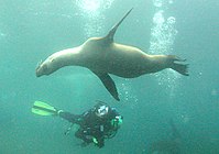 Diver and juvenile sea lions, Anacapa Island
 Sea fan, Anacapa Island
 San Miguel Island
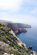 Santa Cruz Island in the spring.
 Anacapa Island Light viewed from the west side of the island


Vessels
The CINP unit operates several vessels in the waters of the park, including the following:
- Surf Ranger LCM-8 landing craft, 74 ft.
- research diving boat Pacific Ranger 56 ft.
- Sea Ranger II 58 ft.
- Ocean Ranger 100 ft.
- Sea Ranger 41 ft (retired).


