Search This Blog

Wednesday, May 10, 2023

Geography of Asia

From Wikipedia, the free encyclopedia
 
Recentissima Asiae Delineatio, the 1730 geographical map of Johan Christoph Homann. Asia is shown in color. The names are in Latin.
 
Satellite view of Asia
 
Modern Asia (1796).tif

Geography of Asia reviews geographical concepts of classifying Asia, the central and eastern part of Eurasia, comprising approximately fifty countries.

Geographical characteristics

Boundary

The land mass of Asia is not the sum of the land masses of each of its regions, which have been defined independently of the whole. For example, the borders of Central Asia and the Middle East depend on who is defining them and for what purpose. These varying definitions are not generally reflected in the map of Asia as a whole; for example, Egypt is typically included in the Middle East, but not in Asia, even though the Middle East is a division of Asia.

The demarcation between Asia and Africa is the isthmus of Suez and the Red Sea. The border with Europe starts with the coast of the eastern Mediterranean, even though Turkey in the Near East extends partly into the Aegean Islands and includes Istanbul on the European side of the Bosphorus. On the north the boundary between the continents of Asia and Europe is commonly regarded as running through the Dardanelles, the Sea of Marmara, the Bosporus, the Black Sea, the Caucasus Mountains, the Caspian Sea, the Ural River to its source, and a long border generally following the eastern side of the Ural Mountains to the Kara Sea, Russia. The Arctic Ocean is the northern border. The Bering Straits divide Asia from North America.

On the southeast of Asia are the Malay Peninsula (the limit of mainland Asia) and Indonesia ("Isles of India", the former East Indies), a vast nation among thousands of islands on the Sunda Shelf, large and small, inhabited and uninhabited. Australia nearby is a different continent. The Pacific islands northeast of Australia more remotely removed from Japan and Korea are Oceania rather than Asia. From Indonesia the border runs along the Indian Ocean to the Red Sea. Most of the islands in the Indian Ocean are Asian.

Overall dimensions

Multiple sources give different estimates of the area enclosed by the imaginary border of Asia. The New York Times Atlas of the World gives 43,608,000 km2 (16,837,000 sq mi). Chambers World Gazetteer rounds off to 44,000,000 km2 (17,000,000 sq mi), while the Concise Columbia Encyclopedia gives 44,390,000 km2 (17,140,000 sq mi). The 2011 Pearson's has 44,030,000 km2 (17,000,000 sq mi). The methods of obtaining these figures and exactly what areas they include have not been divulged.

The map surface of mainland Asia is entirely contained within a Geodetic quadrangle formed from segments of latitude going through its north and south extremes and segments of longitude passing through the east and west extremes. Cape Chelyuskin is at 77° 43′ N; Cape Piai in the Malay Peninsula is at 1° 16′ N; Cape Baba in Turkey is at 26° 4′ E; Cape Dezhnyov is at 169° 40′ W; that is, mainland Asia ranges through about 77° of latitude and 195° of longitude, distances of about 8,560 km (5,320 mi) long by 9,600 km (6,000 mi) wide according to Chambers, or 8,700 km (5,400 mi) long by 9,700 km (6,000 mi) wide according to Pearson's.

Indonesia to the southeast, a nation consisting of thousands of islands, adds a significant amount of territory to mainland Asia and extends the extreme Asian latitude further south. The geographic nature of the country raises such questions as whether the sea and the seabed count as Asia. The Australia–Indonesia border is still being negotiated. Currently, a 1997 treaty remains unratified. As there are questions of fishing rights in the waters and mineral rights in the seabed, two different boundaries are being negotiated, one for the water column and one for the seabed. The southernmost seabed boundary is 10° 50' S, the latitude of Point A3, the Australia, Indonesia and Papua New Guinea common tripoint. The southernmost water column boundary is still further south at Point Z88, 13° 56' 31.8".

European views of Asia

The geographical or traditional view

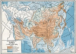
A 1916 physical map of Asia by Tarr and McMurry

Medieval Europeans considered Asia as a continent, a distinct landmass. The European concept of the three continents in the Old World goes back to classical antiquity. Definition of continents has long been and remains primarily the realm of geographers, including cultural geographers as well as physical geographers. A wide majority of geographers, in nearly all atlases and many other publications from the National Geographic to the CIA World Factbook and Merriam-Webster's Geographical Dictionary, define Europe, Asia, and Africa as continents.

The Hellenic origin

The coast of Turkey, original Asian shore seen from a beach on Rhodes

The three-continent system was an idea devised in Archaic Greece, a time of Greek colonial expansion and trade throughout the Mediterranean and the spread of writing again. Writing is a prerequisite of written geography. It had been lost during the preceding Greek Dark Ages, a period of piracy at sea and defensive parochialism on land. The preceding Mycenaean Greece left scant record of some serving women from a locality in the later Asia Minor called Asia. Europe was mainly Greece, while Libya was a small region to the west of Egypt. There was no systematic definition of "continent;" however, the Greek mariners did make a distinction that was to become one: the islands, nēsoi, versus the mainland, ēpeiros. One etymology relates ēpeir- to the same Indo-European root from which English "over" came. The Armenian form means "bank, coast." The Greek form must be some sort of "overland," whether continuous land or a coast that looms over. In Latin it became continens terra, "the continuous land," shortened to just continens, stem continent-.

Most ships of the Archaic Period were not ocean-going. They followed the shores closely, ready to put in at the first sign of trouble. It is not surprising that the first continents were "shores," as they are in Herodotus, first historian whose works are extant, who relies on earlier geography now missing except for fragments. Asia is defined by two akrai, "bluffs" or "shores." One runs from Phasis in Colchis (Georgia) at the eastern end of the Black Sea around the coast of Asia Minor to Phoenicia. The second runs from Phoenicia to the Red Sea (the ancient Red Sea comprised also the Persian Gulf and the Indian Ocean) and from there to India, after which "no man can say what sort of region it is."

Ancient ships in trouble on the sea

Asia is equal to its shores, which also define Europe and Libya. The northern shore runs eastward along the line if the Phasis and Araxes Rivers; that is, south of the Caucasus Mountains, and around the south of the Caspian Sea. The southern shore continues the Red Sea and the Nile River, as Darius the Great had constructed a canal between them. This division and system was already in place before Herodotus. He professes not to understand it: "I am astonished that men should ever have divided Libya, Asia and Europe as they have, for they are exceedingly unequal." His astonishment continues: "I cannot conceive why three names, and women's names especially, should ever have been given to a tract which is in reality one ... nor can I even say who gives the three tracts [akrai] their names." Previously he had spoken of two tracts. He says that an alternate northern border is the mouth of the Don River.

Strabo, geographer of the Early Roman Empire, has an explanation of the geography Herodotus found so puzzling. The key is the coast-hugging requirement of most ancient navigation. As the ancient navigator passed under the Rock of Gibraltar on his way into the Mediterranean Sea ("our sea" to those who lived there), two paths appeared to him, the north shore or the south shore. Strabo says:

"Now as you sail into the strait at the Pillars, Libya lies on your right hand as far as the stream of the Nile, and on your left hand across the strait lies Europe as far as the Tanais."

To the ancient navigators of Our Sea, the continents were separated by seas. The canal extended the southern shore into the Red Sea. The symmetry of the scheme was too geometric for the Greeks to resist, as they represented all geographic masses by regular figures if they could. A triangle prevailed in the Greek imagination with points at the Pillars, the Tanais and the Red Sea. As the sides were three shores, the continents were three.

Imperial Roman geography

The geographer, Claudius Ptolemaeus, distinguishes between geography, which is "a representation in picture of the whole known world," and chorography ("study of places"), which "treats more fully the particulars." The idea of the continents is geography and is presented as such. A chorographer in Ptolemy's view was the expert in a specific locality, such as a ship captain, a merchant, or a native. Geographers consult them but they do not write geography unless they happen to be both.

Ptolemy was a geographer of the middle Roman Empire, an Egyptian. The idea of the continents preceded the imperial Romans but through them reached to modern time to determine today's geographic views, which are enhancements and refinements of the classical. Stating that "continents are bounded more properly, when it is possible, by seas than by rivers," Ptolemy defines a three-continent system: Europe, Libya, Asia. His Libya is the North Africa of today, containing a province, Africa, whose name replaced Libya. Rejecting the Nile River as the Asian border so as not to split Egypt, Ptolemy designates the Red Sea as the border between Libya and Asia. In the north, the border between Asia and Europe is a meridian through the mouth of the Don River northward "to the unknown region." Asia Minor remains "Asia properly so called."

Ptolemy's Asia extends to the Far East, approximately identical to today's Asia, except that the European border runs through the future location of Moscow, then a wilderness of forest skirted by Sarmatian tribesmen. In a striking foreshadowing of European and Asian Russia, European Sarmatia lies between the Vistula River and the Don River, while Asiatic Sarmatia runs east of the Don to Scythia.

Geologic view

The relatively recent study of plate tectonics has discovered that Asia has several regions that would be considered distinct landmasses if strictly geologic and tectonic criteria were used (for example, South Asia and East Asia). Definition of continental plates is the realm of geologists. Strictly in terms of geological landmasses or tectonic plates, Europe is a western peninsula of Eurasia and of the Africa-Eurasia landmass. In the latter, Europe and Asia are parts of the Eurasian plate, which excludes the Arabian and Indian tectonic plates.

Regional view

In human geography, there are several schools of thought. The more common school follows historical convention and treats Europe and Asia as different continents, categorizing East Asia, South Asia, and the Middle East as specific regions for more detailed analysis. Other schools equate the word "continent" to geographical "region" when referring to Europe and Asia in terms of physical geography.

Ethnic view

In European languages, the term "Asian" more commonly refers to ethnic heritage rather than a strict geographic area. In American English, "Asian" often refers to East Asians, while in British English, Asian often refers to South Asians. See the List of transcontinental countries for further geographic definitions. The term Asia Pacific generally refers to a combination of East Asia, Southeast Asia, and islands in the Pacific Ocean – and most are also considered part of Australasia or Oceania. Asia contains the Indian subcontinent, Iranian Plateau, Arabian peninsula, as well as a piece of the North American plate in Siberia.

Regions

Since the 18th century, Asia has been divided into several subregions. There has been no universal consensus on the use of these terms.

The regions of Asia include:

Central Asia
Commonly understood as comprising Kazakhstan, Kyrgyzstan, Tajikistan, Turkmenistan, and Uzbekistan.
East Asia
Commonly understood as comprising China, Hong Kong, Japan, Macau, Mongolia, North Korea, South Korea, and Taiwan. A common synonym for East Asia is Northeast Asia, although some geographers only include Japan, Korea, and Northeast China in this subregion.
South Asia
Commonly understood as comprising Afghanistan, Bangladesh, Bhutan, British Indian Ocean Territory, India, Maldives, Nepal, Pakistan, and Sri Lanka. A common approximate synonym for South Asia is the Indian subcontinent which excludes Afghanistan.
Southeast Asia
Commonly understood as comprising Brunei, Cambodia, Christmas Island, Cocos (Keeling) Islands, East Timor, Indonesia, Laos, Malaysia, Myanmar, Philippines, Singapore, Thailand, and Vietnam. This subregion can be further subdivided into two smaller subregions: Mainland Southeast Asia (Indochinese Peninsula) and Maritime Southeast Asia (Malay Archipelago).
Western Asia
Commonly understood as comprising Armenia, Azerbaijan, Bahrain, Cyprus, Georgia, Iran, Iraq, Israel, Jordan, Kuwait, Lebanon, Oman, Palestine, Qatar, Saudi Arabia, the Sinai Peninsula (Egypt), Syria, Turkey, United Arab Emirates, and Yemen. Common synonyms for Western Asia are Southwest Asia and the Middle East. The Middle East generally includes Egypt, a transcontinental country between Africa and Asia.
North Asia
Commonly understood as comprising Asian Russia. A common synonym for North Asia is Siberia.

Asia's changing climate

A survey carried out in 2010 by global risk analysis firm Maplecroft identified 16 countries that are extremely vulnerable to climate change. Each nation's vulnerability was calculated using 42 social, economic and environmental indicators, which identified the likely climate change impacts during the next 30 years. The Asian countries of Bangladesh, India, Vietnam, Thailand, Pakistan and Sri Lanka were among the 16 countries facing extreme risk from climate change. Some shifts are already occurring. For example, in tropical parts of India with a semi-arid climate, the temperature increased by 0.4 °C between 1901 and 2003. A 2013 study by the International Crops Research Institute for the Semi-Arid Tropics (ICRISAT) aimed to find science-based, pro-poor approaches and techniques that would enable Asia's agricultural systems to cope with climate change, while benefiting poor and vulnerable farmers. The study's recommendations ranged from improving the use of climate information in local planning and strengthening weather-based agro-advisory services, to stimulating diversification of rural household incomes and providing incentives to farmers to adopt natural resource conservation measures to enhance forest cover, replenish groundwater and use renewable energy.

General data for countries defined as Asian by the UNSD

The United Nations Statistics Division, charged with collecting statistical data on global regions including Asia, publishes a classification standard, United Nations M49, which assigns code numbers to continental regions, areas and countries, based on statistical purposes, and the countries and regions grouped together don't imply any assumption regarding political or other affiliations between the grouped countries. Some general data on the countries listed in M49 for the continental region, Asia (142), and one non-official region, "Northern Asia," are presented below.

M49 is a device for collecting useful statistics for the UNSD and is a suggested reference guide offered as a global standard for all agencies and institutions within the various UN departments that might be interested. The United Nations Statistics Division does not present it as an authoritative standard or as one that is more valid or more worthy of adoption than some other. It is not a requirement for other agencies within the United Nations, which use their own standards as are convenient for their operations.

No nations have adopted M49 as a mandatory standard. It does, however, reflect general usage concerning the political geography of Asia. M49 is updated frequently to reflect changing geopolitical circumstances.

One problematic aspect of the classification of Asia not yet definitively addressed by the Statistics Division is "Northern Asia," which has no regional code and is not currently officially a region of Asia. Russia, or "the Russian Federation," is a nation of Europe. The "Northern Asia" name is unofficially recognized; for example, the UN Group of Experts on Geographical Names includes an Eastern Europe, Northern and Central Asia Division. "Northern Asia" comes from traditional usage, which divides Europe from Asia at the Ural Mountains. No one at the UN is suggesting that European Russia be included in Asia or that Asian Russia be included in Europe. Their policy is that a nation shall appear once in one region. They have selected Europe. The problem remains unsolved.

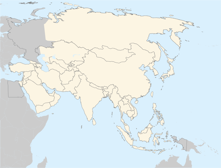
Geopolitical map of Asia

The nations of this map with one major exception (and a few minor ones) are those defined by The World Factbook. Short forms of the names are used; sometimes abbreviations. All the nations can be found in the table below. The one major exception to the scheme is "Russia," not currently officially in the continental region of Asia, but unofficially partly in it even though classified as Europe.

A 1916 political map of Asia by Tarr and McMurry

Geopolitical data for Asia

Introduction

The countries in this table are categorised mainly, but not entirely, according to the UNSD scheme for statistical purposes used by the United Nations Statistics Division. For example, the UNSD statistical geoscheme does not recognize a "North Asia," but problematic differences in point of view reach down to the country level elsewhere as well. Part of Egypt (Sinai Peninsula) is geographically in Western Asia, and the Australian external territories of Christmas Island and the Cocos (Keeling) Islands are often associated with Asia. However, these are not present in the UNSD geoscheme.

There is no universally defined standard Asia. Traditional views are approximate at best. Even today borders are still being defined, as between Indonesia, Australia and Oceania. As long as conflict over territory remains a human trait there may well be "an eastern question," as the British Empire said of the Ottoman Empire.

In evaluating the geographic position of nations of the edge of Asia some writers utilize the amorphous concept of "transcontinental countries," which has different meanings to different authorities. Merriam-Webster defines it as "going across a continent," as might a railroad. With regard to Asia, there is only one such country, the Russian Federation.

In a second definition, Petrovsky refers to a new tendency to form transcontinental agencies, meaning agencies whose jurisdictions cross continental borders, rather than the whole continent. Petrovsky's examples put together widely scattered sections of continents. There is no question of their trans- status. More precise views, however, require definitions of continents, which in the case of Asia are not quite so facile.

A third definition emphasizes transformation in place from one continent to another. Fahey at first defines Turkey as transcontinental by virtue of being in both Anatolia and the Balkans, neglecting the historical circumstance that the Balkans as part of the Ottoman Empire were once Asian, as was much of North Africa. He then hypothesizes that Turkey, accepted into the European Union, is defined by that circumstance to be European. By this usage, the very region to which "Asia" was first applied is now Europe. If it is, Turkey cannot be transcontinental by being split between two continents. This sort of paradox only underlines that Asia has no precise definition in the same way that nations do, to whom a mere 100 yards of border may be of great concern.

Indo-Pacific

From Wikipedia, the free encyclopedia
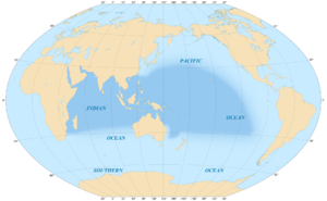
Area covered by the Indo-Pacific biogeographic region.
 
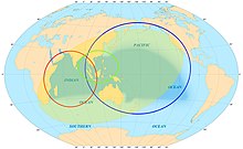
Indo-Pacific. The green circle covers ASEAN.

The Indo-Pacific is a vast biogeographic region of Earth.

In a narrow sense, sometimes known as the Indo-West Pacific or Indo-Pacific Asia, it comprises the tropical waters of the Indian Ocean, the western and central Pacific Ocean, and the seas connecting the two. It does not include the temperate and polar regions of the Indian and Pacific oceans, nor the Tropical Eastern Pacific, along the Pacific coast of the Americas, which is also a distinct marine realm. The term is especially useful in marine biology, ichthyology, and similar fields, since many marine habitats are continuously connected from Madagascar to Japan and Oceania, and a number of species occur over that range, but are not found in the Atlantic Ocean.

The region has an exceptionally high species richness, with the world's highest species richness being found in at its heart in the Coral Triangle and a remarkable gradient of decreasing species richness radiating outward in all directions. The region includes over 3,000 species of fish, compared with around 1,200 in the next richest marine region, the Western Atlantic, and around 500 species of reef building corals, compared with about 50 species in the Western Atlantic.

The term first appeared in academic use in oceanography and geopolitics. Scholarship has shown that the "Indo-Pacific" concept circulated in Weimar Germany, and spread to interwar Japan. German political oceanographers envisioned an "Indo-Pacific" comprising anticolonial India and republican China, as German allies, against "Euro-America". Since the late 2010s, the term "Indo-Pacific" has been increasingly used in geopolitical discourse. It also has a "symbiotic link" with the Quadrilateral Security Dialogue, or "Quad", an informal grouping between Australia, Japan, India, and the United States. It has been argued that the concept may lead to a change in popular "mental maps" of how the world is understood in strategic terms.

In its widest sense, the term geopolitically covers all nations and islands surrounding either the Indian Ocean or the Pacific Ocean, encompassing mainland African and Asian nations who border these oceans, such as India and South Africa, Indian Ocean territories such as the Kerguelen Islands and Seychelles, the Malay Archipelago (which is within the bounds of both the Indian Ocean and the Pacific), Japan, Russia and other Far East nations bordering the Pacific, Australia and all the Pacific Islands east of them, as well as Pacific nations of the Americas such as Canada or Mexico. ASEAN countries (defined as those in Southeast Asia and the Malay Archipelago) are considered to be geographically at the centre of the political Indo-Pacific.

Subdivisions

The figure shows 8 maps of biogeographic regionalizations that were tested using model selection with analysis of molecular variance(AMOVA) by Crandall et al. 2019.
Biogeographic regionalizations that were tested using model selection with analysis of molecular variance(AMOVA) by Crandall et al. 2019. Colours represent different regions within a scheme.

The WWF and Nature Conservancy divide the Indo-Pacific into 3 realms (or subrealms), and each of these into 25 marine provinces and 77 ecoregions (Marine Ecoregions of the World; MEOW) based on data-driven expert opinion. Other schemes for subdivision of the Indo-Pacific have included: 5 provinces, based on endemism in fishes; 3 regions split into 10 provinces based on dissimilarity of fish assemblages, 11 provinces based on range boundaries in corals, 12 divisions split into 124 ecoregions based on biogeographic clustering from coral distributions and finally 8 realms from distributions of 65,000 marine species. All but the last of these schemes were tested against one another by an international consortium of marine scientists using genetic data from 56 Indo-Pacific species, with the reasoning that genetic data should reflect the evolutionary processes that structure the Indo-Pacific. While there was no clear winning scheme, and all schemes were supported by data from at least one species, the genetic data in general favored schemes with few subdivisions, supporting the Indo-Pacific as relatively unstructured biogeographic realm - possibly the world's largest. Below are briefly described the 3 MEOW realms of the Indo-Pacific:

Central Indo-Pacific

The Coral Triangle and countries participating in the Coral Triangle Initiative

The Central Indo-Pacific includes the numerous seas and straits connecting the Indian and Pacific oceans, including the seas surrounding the Indonesian archipelago (with the exception of Sumatra's northwest coast, which is part of the Western Indo-Pacific), the South China Sea, the Philippine Sea, the north coast of Australia, and the seas surrounding New Guinea, western and central Micronesia, New Caledonia, the Solomon Islands, Vanuatu, Fiji, and Tonga. The Central Indo-Pacific, due in part to its central location at the meeting of two oceans, has the greatest richness and diversity of marine organisms, specifically located within the Coral Triangle, which contains 76% of all known coral species in the world.

Eastern Indo-Pacific

The Eastern Indo-Pacific surrounds the mostly volcanic islands of the central Pacific Ocean, extending from the Marshall Islands in the west through central and southeastern Polynesia to Hawaii, to the west coast of Chile. The World Wide Fund for Nature believe the region ends at Chile's Easter Island and Isla Salas y Gómez, although it is sometimes extended even further to include Chile's Desventuradas Islands and Juan Fernández Islands.

Western Indo-Pacific

The Western Indo-Pacific covers the western and central portion of the Indian Ocean, including Africa's east coast, the Red Sea, the Gulf of Aden, the Persian Gulf, the Arabian Sea, the Bay of Bengal, and the Andaman Sea, as well as the coastal waters surrounding Madagascar, Seychelles, the Comoros, the Mascarene Islands, Maldives, and the Chagos Archipelago.

Ecology

Some seashore and coastal plants are found throughout most of the region, including the trees Pisonia grandis, Calophyllum inophyllum, Heliotropium arboreum, Pandanus tectorius, Cordia subcordata, Guettarda speciosa, and the shrubs Scaevola taccada, Suriana maritima, and Pemphis acidula. These plants have adapted to grow on coral sand, and have seeds adapted to crossing salt water, including distribution by birds or which can survive floating in salt water.

The trees coconut (Coco nucifera), candlenut (Aleurites moluccanus), and Morinda citrifolia originated in the Central Indo-Pacific, and were spread further across the region by human settlers.

Economic region

The "Indo-Pacific" has been an economic idea since its early formulation in Weimar Germany. According to Hansong Li, the German geographer Karl Haushofer, son of the economist Max Haushofer, believed that capital, along with urbanisation and population growth, are key vectors that determine the 'manometers' of the oceanic region. Haushofer also explained why industrialisation broke out in Europe rather than the Indo-Pacific by a spatial theory of demography.

In the 21st century, with the rising involvement of the United States in the new growth areas of Asia, the idea of the Indo-Pacific Economic Corridor (IPEC) emerged during the U.S.–India Strategic Dialogue of 2013. The Secretary of State John Kerry referred to the potential of the Indo-Pacific Economic Corridor in transforming the prospects for development and investments as well as for trade and transit between the economies of South and Southeast Asia Indo-Pacific economic corridor.

K. Yhome in his scholarly study has mapped out the potential for various emerging trans-regional corridors in Asia along with the challenges of linking IPEC into the larger web of regional economic integration initiatives taking shape in the region in 2017.

On 23 May 2022, the president of the United States, Joe Biden, launched the Indo-Pacific Economic Framework for Prosperity (IPEF). This agreement includes a dozen of initial partners including: Australia, Brunei, India, Indonesia, Japan, Republic of Korea, Malaysia, New Zealand, the Philippines, Singapore, Thailand, and Vietnam. Together, all the countries included within the framework represent 40% of the world GDP. The IPEF contains four pillars:

  1. Connected Economy: through digital economy rules, data localization, AI, privacy.
  2. Resilient Economy: through better supply chain commitments that better anticipate and prevent disruptions in supply chains.
  3. Clean Economy: with commitments to clean energy, decarbonization, and green infrastructure.
  4. Fair Economy: with recommendation to strengthen efforts to crack down on corruption, effective tax implementation, anti-money laundering, and anti-bribery regimes.

Geopolitical context

Origins

The German geopolitician Karl Haushofer first used "Indo-Pacific" in the 1920s in multiple works on geography and geopolitics: Geopolitics of the Pacific Ocean (1924), Building Blocks of Geopolitics (1928), Geopolitics of Pan-Ideas (1931), and German Cultural Politics in the Indo-Pacific Space (1939). Haushofer legitimated the integration of the two oceans by evidence in marine biology, oceanography, ethnography, and historical philology. He envisioned an "Indo-Pacific" comprising anticolonial forces in India and China, as Germany's ally against the maritime domination of Britain, the United States, and Western Europe.

Contemporary use

The Japanese Prime Minister Shinzō Abe referred to the "confluence" of the Indian and Pacific Oceans in his speech to the Indian Parliament in August 2007 as "the dynamic coupling as seas of freedom and of prosperity" in the "broader Asia". The focus of Japanese Prime Minister's August 2007 speech in the Indian Parliament was on security of sea lanes linking the two oceans. In the academic discourse relating to such maritime security issue in the Indo-Pacific, the first articulation was carried by a paper published in January 2007 by the Institute of Defense Studies and Analyses (IDSA), New Delhi. It was a result of consultations between IDSA and the Japan Institute of International Affairs (JIIA) held in New Delhi in October 2006. From 2010 onwards, the term Indo-Pacific acquired salience within the Indian government and has since been used often by India's apex political leadership. From about 2011 onwards, the term has been used frequently by strategic analysts and high-level government/military leadership in Australia, Japan and the United States to denote said region. However, a formal/official documented articulation of the term first appeared in Australia's Defence White Paper, 2013. It is also "symbiotically linked" with the Quadrilateral Security Dialogue—an informal grouping of like-minded democracies in the region, comprising Australia, India, Japan, and the United States.

Since 2011, the term "Indo-Pacific" is being used increasingly in geopolitical discourse.

In 2013, Indonesian Foreign Minister Marty Natalegawa proposed an "Indo-Pacific Treaty of Friendship and Cooperation" to restore trust, manage unresolved territory disputes, and help countries deal with change in the region. In 2013, U.S. officials have begun using the term "Indo-Asia Pacific".

In 2019, the United States Department of State published a document formalizing the concept of a "Free and Open Indo-Pacific", to be sustained among members of "the Quad", a partnership of four Indo-Pacific democracies led by the United States, in concert with Australia, India, and Japan. "Indo-Pacific" has also featured prominently in top-level U.S. strategic documents such as the 2017 National Security Strategy, the 2018 Nuclear Posture Review, and the 2018 National Defense Strategy. According to Felix Heiduk and Gudrun Wacker at the German Institute for International and Security Affairs, the concept is aimed at containing China and is "primarily understood as a U.S.-led containment strategy directed against China" in Beijing. It has been argued that the concept of the Indo-Pacific may lead to a change in popular "mental maps" of how the world is understood in strategic terms.

The term's profile was raised when it found mention in the joint statement issued by the Indian Prime Minister Narendra Modi and United States President Donald Trump after the former's state visit to the White House on 26 June 2017. "As responsible stewards in the Indo-Pacific region, President Trump and Prime Minister Modi agreed that a close partnership between the United States and India is central to peace and stability in the region. In marking 70 years of diplomatic relations between India and the United States, the leaders resolved to expand and deepen the strategic partnership between the countries and advance common objectives. Above all, these objectives include combatting terrorist threats, promoting stability across the Indo-Pacific region, increasing free and fair trade, and strengthening energy linkages". However, President Trump's November 2017 articulation on Indo-Pacific was widely seen as something that would usher in a new (US–China) Cold War. This led to the Indian Prime Minister spelling out the Indian vision of Indo-Pacific as an enabler for "a common pursuit of progress and prosperity... not directed against any country... (albeit based on) our principled commitment to rule of law". According to Dr. Cenk Tamer, the U.S. seeks to create an "anti-China axis" in the Asia-Pacific region through the conceptualization of the Indo-Pacific because it sees India as a key part in containing China. This was reiterated by President Biden, who declared a "secure and prosperous Indo-Pacific." Tamer calls the Indo-Pacific a concept that started to gain ground in international relations as a geopolitical challenge by the U.S. toward China.

Criticism

The Australian Citizens Party, a minor third party associated with the LaRouche movement, criticises the "Indo-Pacific" vision as a reenactment of Nazi strategy, given the concept's link to Karl Haushofer.

Former Prime Minister of Australia Paul Keating, in a televised address at the National Press Club, criticised the notion of the "Indo-Pacific" as a construct of the United States in its diplomatic war with China:

The United States says, well, that's all very interesting. But look, if you behave yourself, you Chinese. You can be a stakeholder in our system. And look, you wouldn't have to be Xi Jinping or anybody, to take the view of your Chinese Nationalist say, "Well, hang on, let me get this right. We are already one and a quarter times bigger than you, will soon be twice as big as you, and we may be two and a half times as big as you. But we can be a stakeholder in your system, is that it?" I mean, it’d make a cat laugh.

Austroasiatic languages

From Wikipedia, the free encyclopedia
Austroasiatic
Austro-Asiatic
Geographic
distribution
Southeast and South Asia
Linguistic classificationOne of the world's primary language families
Proto-languageProto-Austroasiatic
Subdivisions
ISO 639-5aav
Glottologaust1305
Austroasiatic-en.svg
Austroasiatic languages

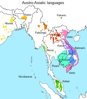
The Austroasiatic languages /ˌɒstr.ʒiˈætɪk, ˌɔː-/, are a large language family in Mainland Southeast Asia and South Asia. These languages are scattered throughout parts of Thailand, Laos, India, Myanmar, Malaysia, Bangladesh, Nepal, and southern China. Austroasiatic constitute the majority languages of Vietnam and Cambodia. There are around 117 million speakers of Austroasiatic languages. Of these languages, only Vietnamese, Khmer, and Mon have a long-established recorded history. Only two have official status as modern national languages: Vietnamese in Vietnam and Khmer in Cambodia. The Mon language is a recognized indigenous language in Myanmar and Thailand. In Myanmar, the Wa language is the de facto official language of Wa State. Santali is one of the 22 scheduled languages of India. The rest of the languages are spoken by minority groups and have no official status.

Ethnologue identifies 168 Austroasiatic languages. These form thirteen established families (plus perhaps Shompen, which is poorly attested, as a fourteenth), which have traditionally been grouped into two, as Mon–Khmer, and Munda. However, one recent classification posits three groups (Munda, Mon-Khmer, and Khasi–Khmuic), while another has abandoned Mon–Khmer as a taxon altogether, making it synonymous with the larger family.

Austroasiatic languages have a disjunct distribution across Southeast Asia and parts of India, Bangladesh, Nepal and Southern China, separated by regions where other languages are spoken. They appear to be the extant original languages of Mainland Southeast Asia (excluding the Andaman Islands), with the neighboring, and sometimes surrounding, Kra–Dai, Hmong-Mien, Austronesian, and Sino-Tibetan languages being the result of later migrations.

Etymology

The name Austroasiatic was coined by Wilhelm Schmidt (German: austroasiatisch) based on auster, the Latin word for "South" (but idiosycratically used by Schmidt to refer to the southeast), and "Asia". Despite the literal meaning of its name, only three Austroasiatic branches are actually spoken in South Asia: Khasic, Munda, and Nicobarese.

Typology

Regarding word structure, Austroasiatic languages are well known for having an iambic "sesquisyllabic" pattern, with basic nouns and verbs consisting of an initial, unstressed, reduced minor syllable followed by a stressed, full syllable. This reduction of presyllables has led to a variety among modern languages of phonological shapes of the same original Proto-Austroasiatic prefixes, such as the causative prefix, ranging from CVC syllables to consonant clusters to single consonants. As for word formation, most Austroasiatic languages have a variety of derivational prefixes, many have infixes, but suffixes are almost completely non-existent in most branches except Munda, and a few specialized exceptions in other Austroasiatic branches.

The Austroasiatic languages are further characterized as having unusually large vowel inventories and employing some sort of register contrast, either between modal (normal) voice and breathy (lax) voice or between modal voice and creaky voice. Languages in the Pearic branch and some in the Vietic branch can have a three- or even four-way voicing contrast.

However, some Austroasiatic languages have lost the register contrast by evolving more diphthongs or in a few cases, such as Vietnamese, tonogenesis. Vietnamese has been so heavily influenced by Chinese that its original Austroasiatic phonological quality is obscured and now resembles that of South Chinese languages, whereas Khmer, which had more influence from Sanskrit, has retained a more typically Austroasiatic structure.

Proto-language

Much work has been done on the reconstruction of Proto-Mon–Khmer in Harry L. Shorto's Mon–Khmer Comparative Dictionary. Little work has been done on the Munda languages, which are not well documented. With their demotion from a primary branch, Proto-Mon–Khmer becomes synonymous with Proto-Austroasiatic. Paul Sidwell (2005) reconstructs the consonant inventory of Proto-Mon–Khmer as follows:

*p *t *c *k
*b *d


*m *n
*w *l, *r *j


*s

*h

This is identical to earlier reconstructions except for . is better preserved in the Katuic languages, which Sidwell has specialized in.

Internal classification

Linguists traditionally recognize two primary divisions of Austroasiatic: the Mon–Khmer languages of Southeast Asia, Northeast India and the Nicobar Islands, and the Munda languages of East and Central India and parts of Bangladesh, parts of Nepal. However, no evidence for this classification has ever been published.

Each of the families that is written in boldface type below is accepted as a valid clade. By contrast, the relationships between these families within Austroasiatic are debated. In addition to the traditional classification, two recent proposals are given, neither of which accepts traditional "Mon–Khmer" as a valid unit. However, little of the data used for competing classifications has ever been published, and therefore cannot be evaluated by peer review.

In addition, there are suggestions that additional branches of Austroasiatic might be preserved in substrata of Acehnese in Sumatra (Diffloth), the Chamic languages of Vietnam, and the Land Dayak languages of Borneo (Adelaar 1995).

Diffloth (1974)

Diffloth's widely cited original classification, now abandoned by Diffloth himself, is used in Encyclopædia Britannica and—except for the breakup of Southern Mon–Khmer—in Ethnologue.

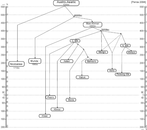
Peiros (2004)

Peiros is a lexicostatistic classification, based on percentages of shared vocabulary. This means that languages can appear to be more distantly related than they actually are due to language contact. Indeed, when Sidwell (2009) replicated Peiros's study with languages known well enough to account for loans, he did not find the internal (branching) structure below.

AustroAsiatic tree Peiros2004.png

Diffloth (2005)

Diffloth compares reconstructions of various clades, and attempts to classify them based on shared innovations, though like other classifications the evidence has not been published. As a schematic, we have:

Austro‑Asiatic 
 Munda 


Remo


Savara


KhariaJuang


Korku


Kherwarian


 Khasi – Khmuic 


Khmuic


Pakanic


Palaungic


Khasian


 (Nuclear)  Mon–Khmer 


Vietic


Katuic


Bahnaric


Khmer


Pearic


Nicobarese


Aslian


Monic


Or in more detail,

  • Koraput: 7 languages
  • Core Munda languages
  • Kharian–Juang: 2 languages
  • North Munda languages
Korku
Kherwarian: 12 languages
  • Khasian: 3 languages of north eastern India and adjacent region of Bangladesh
  • Palaungo-Khmuic languages
  • Khmuic: 13 languages of Laos and Thailand
  • Palaungo-Pakanic languages
Pakanic or Palyu: 4 or 5 languages of southern China and Vietnam
Palaungic: 21 languages of Burma, southern China, and Thailand
  • Nuclear Mon–Khmer languages
  • Khmero-Vietic languages (Eastern Mon–Khmer)
  • Vieto-Katuic languages ?
Vietic: 10 languages of Vietnam and Laos, including Muong and Vietnamese, which has the most speakers of any Austroasiatic language.
Katuic: 19 languages of Laos, Vietnam, and Thailand.
  • Khmero-Bahnaric languages
  • Bahnaric: 40 languages of Vietnam, Laos, and Cambodia.
  • Khmeric languages
The Khmer dialects of Cambodia, Thailand, and Vietnam.
Pearic: 6 languages of Cambodia.
  • Nico-Monic languages (Southern Mon–Khmer)
  • Asli-Monic languages
Aslian: 19 languages of peninsular Malaysia and Thailand.
Monic: 2 languages, the Mon language of Burma and the Nyahkur language of Thailand.

Sidwell (2009–2015)

Paul Sidwell and Roger Blench propose that the Austroasiatic phylum dispersed via the Mekong River drainage basin.

Paul Sidwell (2009), in a lexicostatistical comparison of 36 languages which are well known enough to exclude loanwords, finds little evidence for internal branching, though he did find an area of increased contact between the Bahnaric and Katuic languages, such that languages of all branches apart from the geographically distant Munda and Nicobarese show greater similarity to Bahnaric and Katuic the closer they are to those branches, without any noticeable innovations common to Bahnaric and Katuic.

He therefore takes the conservative view that the thirteen branches of Austroasiatic should be treated as equidistant on current evidence. Sidwell & Blench (2011) discuss this proposal in more detail, and note that there is good evidence for a Khasi–Palaungic node, which could also possibly be closely related to Khmuic.

If this would the case, Sidwell & Blench suggest that Khasic may have been an early offshoot of Palaungic that had spread westward. Sidwell & Blench (2011) suggest Shompen as an additional branch, and believe that a Vieto-Katuic connection is worth investigating. In general, however, the family is thought to have diversified too quickly for a deeply nested structure to have developed, since Proto-Austroasiatic speakers are believed by Sidwell to have radiated out from the central Mekong river valley relatively quickly.

Subsequently, Sidwell (2015a: 179) proposed that Nicobarese subgroups with Aslian, just as how Khasian and Palaungic subgroup with each other.

Austroasiatic: Mon–Khmer

Munda


 Khasi–Palaungic 

Khasian


Palaungic


Khmuic


Mang


Pakanic


Vietic


Katuic


Bahnaric


Khmer


Pearic


 Aslian–Monic 

Monic


Aslian


Nicobarese


?Shompen


A subsequent computational phylogenetic analysis (Sidwell 2015b) suggests that Austroasiatic branches may have a loosely nested structure rather than a completely rake-like structure, with an east–west division (consisting of Munda, Khasic, Palaungic, and Khmuic forming a western group as opposed to all of the other branches) occurring possibly as early as 7,000 years before present. However, he still considers the subbranching dubious.

Integrating computational phylogenetic linguistics with recent archaeological findings, Paul Sidwell (2015c) further expanded his Mekong riverine hypothesis by proposing that Austroasiatic had ultimately expanded into Indochina from the Lingnan area of southern China, with the subsequent Mekong riverine dispersal taking place after the initial arrival of Neolithic farmers from southern China.

Sidwell (2015c) tentatively suggests that Austroasiatic may have begun to split up 5,000 years B.P. during the Neolithic transition era of mainland Southeast Asia, with all the major branches of Austroasiatic formed by 4,000 B.P. Austroasiatic would have had two possible dispersal routes from the western periphery of the Pearl River watershed of Lingnan, which would have been either a coastal route down the coast of Vietnam, or downstream through the Mekong River via Yunnan. Both the reconstructed lexicon of Proto-Austroasiatic and the archaeological record clearly show that early Austroasiatic speakers around 4,000 B.P. cultivated rice and millet, kept livestock such as dogs, pigs, and chickens, and thrived mostly in estuarine rather than coastal environments.

At 4,500 B.P., this "Neolithic package" suddenly arrived in Indochina from the Lingnan area without cereal grains and displaced the earlier pre-Neolithic hunter-gatherer cultures, with grain husks found in northern Indochina by 4,100 B.P. and in southern Indochina by 3,800 B.P. However, Sidwell (2015c) found that iron is not reconstructable in Proto-Austroasiatic, since each Austroasiatic branch has different terms for iron that had been borrowed relatively lately from Tai, Chinese, Tibetan, Malay, and other languages.

During the Iron Age about 2,500 B.P., relatively young Austroasiatic branches in Indochina such as Vietic, Katuic, Pearic, and Khmer were formed, while the more internally diverse Bahnaric branch (dating to about 3,000 B.P.) underwent more extensive internal diversification. By the Iron Age, all of the Austroasiatic branches were more or less in their present-day locations, with most of the diversification within Austroasiatic taking place during the Iron Age.

Paul Sidwell (2018) considers the Austroasiatic language family to have rapidly diversified around 4,000 years B.P. during the arrival of rice agriculture in Indochina, but notes that the origin of Proto-Austroasiatic itself is older than that date. The lexicon of Proto-Austroasiatic can be divided into an early and late stratum. The early stratum consists of basic lexicon including body parts, animal names, natural features, and pronouns, while the names of cultural items (agriculture terms and words for cultural artifacts, which are reconstructible in Proto-Austroasiatic) form part of the later stratum.

Roger Blench (2017) suggests that vocabulary related to aquatic subsistence strategies (such as boats, waterways, river fauna, and fish capture techniques) can be reconstructed for Proto-Austroasiatic. Blench (2017) finds widespread Austroasiatic roots for 'river, valley', 'boat', 'fish', 'catfish sp.', 'eel', 'prawn', 'shrimp' (Central Austroasiatic), 'crab', 'tortoise', 'turtle', 'otter', 'crocodile', 'heron, fishing bird', and 'fish trap'. Archaeological evidence for the presence of agriculture in northern Indochina (northern Vietnam, Laos, and other nearby areas) dates back to only about 4,000 years ago (2,000 BC), with agriculture ultimately being introduced from further up to the north in the Yangtze valley where it has been dated to 6,000 B.P.

Sidwell (2022) proposes that the locus of Proto-Austroasiatic was in the Red River Delta area about 4,000-4,500 years before present, instead of the Middle Mekong as he had previously proposed. Austroasiatic dispersed coastal maritime routes and also upstream through river valleys. Khmuic, Palaungic, and Khasic resulted from a westward dispersal that ultimately came from the Red Valley valley. Based on their current distributions, about half of all Austroasiatic branches (including Nicobaric and Munda) can be traced to coastal maritime dispersals.

Hence, this points to a relatively late riverine dispersal of Austroasiatic as compared to Sino-Tibetan, whose speakers had a distinct non-riverine culture. In addition to living an aquatic-based lifestyle, early Austroasiatic speakers would have also had access to livestock, crops, and newer types of watercraft. As early Austroasiatic speakers dispersed rapidly via waterways, they would have encountered speakers of older language families who were already settled in the area, such as Sino-Tibetan.

Sidwell (2018)

Sidwell (2018) (quoted in Sidwell 2021) gives a more nested classification of Austroasiatic branches as suggested by his computational phylogenetic analysis of Austroasiatic languages using a 200-word list. Many of the tentative groupings are likely linkages. Pakanic and Shompen were not included.

Austroasiatic
 Eastern 


Bahnaric


 Vietic–Katuic 

Vietic


Katuic


Khmeric


Pearic


Mang


 Northern 

Khmuic


 Khasi–Palaungic 

Khasian


Palaungic


Monic


 Southern 

Nicobarese


Aslian


Munda


Possible extinct branches

Roger Blench (2009) also proposes that there might have been other primary branches of Austroasiatic that are now extinct, based on substrate evidence in modern-day languages.

  • Pre-Chamic languages (the languages of coastal Vietnam before the Chamic migrations). Chamic has various Austroasiatic loanwords that cannot be clearly traced to existing Austroasiatic branches (Sidwell 2006, 2007). Larish (1999) also notes that Moklenic languages contain many Austroasiatic loanwords, some of which are similar to the ones found in Chamic.
  • Acehnese substratum (Sidwell 2006). Acehnese has many basic words that are of Austroasiatic origin, suggesting that either Austronesian speakers have absorbed earlier Austroasiatic residents in northern Sumatra, or that words might have been borrowed from Austroasiatic languages in southern Vietnam – or perhaps a combination of both. Sidwell (2006) argues that Acehnese and Chamic had often borrowed Austroasiatic words independently of each other, while some Austroasiatic words can be traced back to Proto-Aceh-Chamic. Sidwell (2006) accepts that Acehnese and Chamic are related, but that they had separated from each other before Chamic had borrowed most of its Austroasiatic lexicon.
  • Bornean substrate languages (Blench 2010). Blench cites Austroasiatic-origin words in modern-day Bornean branches such as Land Dayak (Bidayuh, Dayak Bakatiq, etc.), Dusunic (Central Dusun, Visayan, etc.), Kayan, and Kenyah, noting especially resemblances with Aslian. As further evidence for his proposal, Blench also cites ethnographic evidence such as musical instruments in Borneo shared in common with Austroasiatic-speaking groups in mainland Southeast Asia. Adelaar (1995) has also noticed phonological and lexical similarities between Land Dayak and Aslian. Kaufman (2018) presents dozens of lexical comparisons showing similarities between various Bornean and Austroasiatic languages.
  • Lepcha substratum ("Rongic"). Many words of Austroasiatic origin have been noticed in Lepcha, suggesting a Sino-Tibetan superstrate laid over an Austroasiatic substrate. Blench (2013) calls this branch "Rongic" based on the Lepcha autonym Róng.

Other languages with proposed Austroasiatic substrata are:

  • Jiamao, based on evidence from the register system of Jiamao, a Hlai language (Thurgood 1992). Jiamao is known for its highly aberrant vocabulary in relation to other Hlai languages.
  • Kerinci: van Reijn (1974) notes that Kerinci, a Malayic language of central Sumatra, shares many phonological similarities with Austroasiatic languages, such as sesquisyllabic word structure and vowel inventory.

John Peterson (2017) suggests that "pre-Munda" ("proto-" in regular terminology) languages may have once dominated the eastern Indo-Gangetic Plain, and were then absorbed by Indo-Aryan languages at an early date as Indo-Aryan spread east. Peterson notes that eastern Indo-Aryan languages display many morphosyntactic features similar to those of Munda languages, while western Indo-Aryan languages do not.

Writing systems

Other than Latin-based alphabets, many Austroasiatic languages are written with the Khmer, Thai, Lao, and Burmese alphabets. Vietnamese divergently had an indigenous script based on Chinese logographic writing. This has since been supplanted by the Latin alphabet in the 20th century. The following are examples of past-used alphabets or current alphabets of Austroasiatic languages.

External relations

Austric languages

Austroasiatic is an integral part of the controversial Austric hypothesis, which also includes the Austronesian languages, and in some proposals also the Kra–Dai languages and the Hmong–Mien languages.

Hmong-Mien

Several lexical resemblances are found between the Hmong-Mien and Austroasiatic language families (Ratliff 2010), some of which had earlier been proposed by Haudricourt (1951). This could imply a relation or early language contact along the Yangtze.

According to Cai (et al. 2011), Hmong–Mien is at least partially related to Austroasiatic but was heavily influenced by Sino-Tibetan, especially Tibeto-Burman languages.

Indo-Aryan languages

It is suggested that the Austroasiatic languages have some influence on Indo-Aryan languages including Sanskrit and middle Indo-Aryan languages. Indian linguist Suniti Kumar Chatterji pointed that a specific number of substantives in languages such as Hindi, Punjabi and Bengali were borrowed from Munda languages. Additionally, French linguist Jean Przyluski suggested a similarity between the tales from the Austroasiatic realm and the Indian mythological stories of Matsyagandha (from Mahabharata) and the Nāgas.

Austroasiatic migrations and archaeogenetics

Mitsuru Sakitani suggests that Haplogroup O1b1, which is common in Austroasiatic people and some other ethnic groups in southern China, and haplogroup O1b2, which is common in today's Japanese, Koreans and, are the carriers of early rice-agriculturalists from Indochina. Another study suggests that the haplogroup O1b1 is the major Austroasiatic paternal lineage and O1b2 the "para-Austroasiatic" lineage of the, Korean and Yayoi people.

The Austroasiatic migration route began earlier than the Austronesian expansion, but later migrations of Austronesians resulted in the assimilation of the pre-Austronesian Austroasiatic populations.

A full genomic study by Lipson et al. (2018) identified a characteristic lineage that can be associated with the spread of Austroasiatic languages in Southeast Asia and which can be traced back to remains of Neolithic farmers from Mán Bạc (ca. 2000 BCE) in the Red River Delta in northern Vietnam, and to closely related Ban Chiang and Vat Komnou remains in Thailand and Cambodia respectively. This Austroasiatic lineage can be modeled as a sister group of the Austronesian peoples with significant admixture (ca. 30%) from a deeply diverging eastern Eurasian source (modeled by the authors as sharing some genetic drift with the Onge, a modern Andamanese hunter-gatherer group) and which is ancestral to modern Austroasiatic-speaking groups of Southeast Asia such as the Mlabri and the Nicobarese, and partially to the Austroasiatic Munda-speaking groups of Southeast Asia (e.g. the Juang). Significant levels of Austroasiatic ancestry were also found in Austronesian-speaking groups of Sumatra and Borneo. Austroasiatic-speaking groups in southern China (such as the Wa and Blang in Yunnan) predominatly carry the same Mainland Southeast Asian Neolithic farmer ancestry, but with additional geneflow from northern and southern East Asian lineages that can be associated with the spread of Tibeto-Burman and Kra-Dai languages, respectively.

Larena et al. 2021 could reproduce the genetic evidence for the origin of Basal East Asians in Mainland Southeast Asia, which are estimated to have formed about 50kya years ago, and expanded through multiple migration waves southwards and northwards. Early Austroasiatic speakers are estimated to have originated from an lineage, which split from Ancestral East Asians between 25,000 and 15,000 years ago, and were among the first wave to replace distinct Australasian-related groups in Insular Southeast Asia. East Asian-related ancestry became dominant in Insular Southeast Asia already between 15,000 years to 12,000 years ago, and may be associated with Austroasiatic groups, which however got again replaced by later Austronesian groups some 10,000 to 7,000 years ago. Early Austroasiatic people were found to be best represented by the Mlabri people in modern day Thailand. Proposals for Austroasiatic substratum among later Austronesian languages in Western Indonesia, noteworthy among the Dayak languages, is strengthened by genetic data, suggesting Austroasiatic speakers were assimilated by Austronesian speakers.

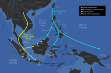
Austroasiatic possible migration routes

Migration into India

According to Chaubey et al., "Austro-Asiatic speakers in India today are derived from dispersal from Southeast Asia, followed by extensive sex-specific admixture with local Indian populations." According to Riccio et al., the Munda people are likely descended from Austroasiatic migrants from Southeast Asia.

According to Zhang et al., Austroasiatic migrations from Southeast Asia into India took place after the last Glacial maximum, circa 10,000 years ago. Arunkumar et al., suggest Austroasiatic migrations from Southeast Asia occurred into Northeast India 5.2 ± 0.6 kya and into East India 4.3 ± 0.2 kya.

Delayed-choice quantum eraser

From Wikipedia, the free encyclopedia https://en.wikipedia.org/wiki/Delayed-choice_quantum_eraser A delayed-cho...