Search This Blog

Wednesday, August 8, 2018

Polynesian culture

From Wikipedia, the free encyclopedia
 
Female dancers of the Sandwich Islands depicted by Louis Choris, the artist aboard the Russian ship Rurick, which visited Hawai'i in 1816

Polynesian culture is the culture of the indigenous peoples of Polynesia who share common traits in language, customs and society. Sequentially, the development of Polynesian culture can be divided into four different historical eras:
  • Exploration and settlement (c. 1800 BC – c. AD 700)
  • Development in isolation (c. 700 – 1595)
  • European encounter and colonization until World War II (1595–1946)
  • Modern times/After World War II

Origins, exploration and settlement (c. 1800 BC – c. 700 AD)

From Taiwan through Melanesia to Polynesia, and earlier migration to Australia and New Guinea. New Zealand was one of the last major lands to be settled by humans.
 
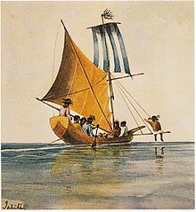
Tahitian sailing canoes, c. 1846 and 1847

Maternal mitochondrial DNA analysis suggests that Polynesians, including Samoans, Tongans, Niueans, Cook Islanders, Tahitians, Hawaiians, Marquesans and Māori, are genetically linked to indigenous peoples of parts of Maritime Southeast Asia including those of Taiwanese aborigines. This DNA evidence is supported by linguistic and archaeological evidence.[1] Recent studies into paternal Y chromosome analysis shows that Polynesians are also genetically linked to peoples of Melanesia.[2]

Between about 2000 and 1000 BC speakers of Austronesian languages spread through Maritime South-East Asia – almost certainly starting out from Taiwan[3] – into the edges of western Micronesia and on into Melanesia. In the archaeological record there are well-defined traces of this expansion which allow the path it took to be followed and dated with a degree of certainty. In the mid-2nd millennium BC a distinctive culture appeared suddenly in north-west Melanesia, in the Bismarck Archipelago, the chain of islands forming a great arc from New Britain to the Admiralty Islands. This culture, known as Lapita, stands out in the Melanesian archeological record, with its large permanent villages on beach terraces along the coasts. Particularly characteristic of the Lapita culture is the making of pottery, including a great many vessels of varied shapes, some distinguished by fine patterns and motifs pressed into the clay. Within a mere three or four centuries between about 1300 and 900 BC, the Lapita culture spread 6000 km further to the east from the Bismarck Archipelago, until it reached as far as Samoa and Tonga. In this region, the distinctive Polynesian culture developed.

The Proto-Polynesians who find their origins in Maritime Southeast Asia were an adventurous seafaring people with highly developed navigation skills. They perfected their seafaring and boat-craft techniques as each successive generations "island-hopped", starting from the island of Taiwan through the Philippine and Indonesian archipelagos and west to the Marianas, finally dispersing throughout the Pacific Ocean. They colonised previously unsettled islands by making very long canoe voyages, in some cases against the prevailing winds and tides. Polynesian navigators steered by the sun and the stars, and by careful observations of cloud reflections and bird flight patterns, were able to determine the existence and location of islands. The name given to a star or constellation taken as a mark to steer by was kaweinga. The discovery of new islands and island groups was by means of entire small villages called vanua or "banwa" setting sail on great single and double-hulled canoes. Archaeological evidence indicates that by about 1280 AD, these voyagers had settled the vast Polynesian triangle with its northern corner at Hawaii, the eastern corner at Rapa Nui (Easter Island), and lastly the southern corner in New Zealand.[4] By comparison, Viking navigators first settled Iceland around 875 AD. There have been suggestions that Polynesian voyagers reached the South American mainland. Carbon-dating of chicken bones found by Chilean archaeologists on the Arauco Peninsula in south-central Chile was thought to date from between 1321 and 1407 AD. This initial report suggested a Polynesian pre-Columbian origin. However, a later report looking at the same specimens concluded:
A published, apparently pre-Columbian, Chilean specimen and six pre-European Polynesian specimens also cluster with the same European/Indian subcontinental/Southeast Asian sequences, providing no support for a Polynesian introduction of chickens to South America. In contrast, sequences from two archaeological sites on Easter Island group with an uncommon haplogroup from Indonesia, Japan, and China and may represent a genetic signature of an early Polynesian dispersal. Modeling of the potential marine carbon contribution to the Chilean archaeological specimen casts further doubt on claims for pre-Columbian chickens, and definitive proof will require further analyses of ancient DNA sequences and radiocarbon and stable isotope data from archaeological excavations within both Chile and Polynesia.[5]
The cultivation before western exploration by many Polynesian cultures of the sweet potato, a South American plant, is also evidence for contact. Sweet potato has been radiocarbon-dated in the Cook Islands to 1000 AD, and current thinking is that it was brought to central Polynesia around 700 AD, possibly by Polynesians who had traveled to South America and back, and spread across Polynesia to Hawaii and New Zealand from there.[6][7]

Development in isolation: (c. 700 to 1595)

Birdmen (Tangata manu) paintings in a cave at the foot of Rano Kau, Rapa Nui (Easter island).
 
"Bird King" (Sarimanok) wood carving from Maranao, Mindanao.

While the early Polynesians were skilled navigators, most evidence indicates that their primary exploratory motivation was to ease the demands of burgeoning populations. Polynesian mythology does not speak of explorers bent on conquest of new territories, but rather of heroic discoverers of new lands for the benefit of those who voyaged with them.

While further influxes of immigrants from other Polynesian islands sometimes augmented the growth and development of the local population, for the most part, each island or island group's culture developed in isolation. There was no widespread inter-island group communication, nor is there much indication during this period of any interest in such communications, at least not for economic reasons. However, almost all these isolated colonies originating from Maritime Southeast Asia still retained the strong influence of their ancestral culture. These are very obvious in social hierarchies, language, and technology which point to a common source with the Dayaks, Tao, Ifugao, and Bajau.

During the period following complete settlement of Polynesia, each local population developed politically in diverse ways, from fully developed kingdoms in some islands and island groups, to constantly warring tribes or extended family groups between various sections of islands, or in some cases, even within the same valleys on various islands.

While it is likely that population pressures caused tensions between various groups, the primary force that seems to have driven unity or division among tribes and family groups is geophysical: on low islands, where communications are essentially unimpeded, there does not appear to have developed any widely observable incidence of conflict.

Meanwhile, on most high islands, there were, historically, warring groups inhabiting various districts, usually delimited primarily by mountain ridges, with carefully drawn lowland boundaries. Early on, however, many such islands developed a united social and political structure, usually under the leadership of a strong monarch. An example is the Marquesas Islands, which, unlike other high-island groups in Polynesia, are not surrounded by fringing coral reefs, and consequently have no low coastal plains. Every valley in the Marquesas is accessible to other valleys only via boat, or by traveling over steep mountain ridges.

European contact and colonization, until World War II (1595 to 1945)

The first Polynesian islands visited by European explorers were the Marquesas Islands, first discovered by Europeans when the Spanish navigator, Álvaro de Mendaña de Neira, found the islands in 1595.

Because of the paucity of mineral or gemological resources, the exploration of Polynesia by European navigators (whose primary interest was economic), was of little more than passing interest. The great navigator Captain James Cook was the first to attempt to explore as much of Polynesia as possible.

Following the initial European contacts with Polynesia, a great number of changes occurred within Polynesian culture, mostly as a result of colonization by European powers, the introduction of a large number of alien diseases to which the Polynesians had no immunity, slaving ventures to supply plantations in South America, and an influx of Christian missionaries, many of whom regarded the Polynesians as descendants of the lost tribes of Israel. In many cases, colonizing powers, usually under pressure from missionary elements, forcibly suppressed native cultural expression, including the use of the native Polynesian languages.

By the early 20th century, almost all of Polynesia was colonized or occupied to various degrees by Western colonial powers, as follows:
All of the Polynesian outliers were subsumed into the sometimes-overlapping territorial claims of Japan, the United Kingdom and France.

During World War II, a number of Polynesian islands played critical roles. The critical attack that brought the United States into the war was the Japanese attack on Pearl Harbor, in south-central Oahu, Hawaii.

A number of islands were developed by the Allies as military bases, especially by the American forces, including as far east as Bora Bora.

Modern times/after World War II (1945 to present)

Following World War II, political change came more slowly to the islands of Polynesia than to the other parts of overseas colonies of European powers. Although sovereignty was granted by royal proclamation to New Zealand as early as 1907, this did not go into full effect until 1947.

Following in independence were the nations (and the sovereign powers from which they obtained complete political independence) of:
  • Samoa, as "Western Samoa" (from New Zealand) in 1962
  • Tuvalu (from the United Kingdom) in 1978
  • the Phoenix Islands and most of the Line Islands as part of the republic of Kiribati (from the United Kingdom) in 1979
  • Niue (from New Zealand) in 1974[8][9]
  • Tonga was never actually a colony, but a limited protectorate of the United Kingdom. Tonga never relinquished internal self-government, but when external foreign affairs were again decided by Tongans without reference to the United Kingdom in 1970, Tonga was said to have rejoined the Comity of Nations. Tonga is the only island group in the South Pacific that was never colonised by a European power.
The remaining islands are still under official sovereignty of the following nations:
The various outliers lie in the sovereign territory of the nations of Vanuatu, the Solomon Islands, Fiji, the Federated States of Micronesia, and the French territory of New Caledonia. Hawaii became a state of the United States, giving it equal political status to the other 49 states.

Independence and increasing autonomy is not the only influence affecting modern Polynesian society. The primary driving forces are, in fact, the ever-increasing accessibility of the islands to outside influences, through improved air communications as well as through vastly improved telecommunications capabilities. The economic importance of tourism has also had a tremendous impact on the direction of the development of the various island societies. Accessibility of outside sources, as well as the tourism viability of individual islands, has played an important role to which the modern culture has adapted itself to accommodate the interests of outsiders, as opposed to the influences of those intent upon promoting the retention of native traditions. Because of this, Polynesia is today an area in varying degrees of extreme cultural flux.

In the genetics of Polynesians today, the gene pool is mixed with many different peoples. Hawaii being the main example, had a high influx of Asians such as Filipinos, Koreans, Japanese, and Chinese during the late 19th century and into the 20th century for plantation work. It has thus led to pure Hawaiian-Polynesians being few and far between.

Genetically engineered peptides on 2D nanosheets form bio-nano interfaces

A first step towards future self-assembled solid-state biomedical and electro-optical nanodevices
October 4, 2016
Original link:  http://www.kurzweilai.net/genetically-engineered-peptides-on-2d-nanosheets-form-bio-nano-interfaces
A top view of GrBP5 nanowires on a 2-D surface of graphene (credit: Mehmet Sarikaya/Scientific Reports)

Engineers at the University of Washington have created genetically engineered peptides that self-assemble into arrays of nanowires on two-dimensional nanosheets (single-layer graphene and molybdenum disulfide) to relay information across a bio-nano interface — a first step towards fully self-assembled future biomedical and electro-optical bionanoelectronic devices.

Arrays of peptides could provide organized scaffolds for functional biomolecules, enabling nanoscale bioelectronics interfaces. And designed peptides could be incorporated with metal ions or nanoparticles with specific physical characteristics, thus fine-tuning 2D device performance for chemical and biological sensors.

A bridge between biology and technology

“Bridging this divide would be the key to building the genetically engineered biomolecular solid-state devices of the future,” said UW professor Mehmet Sarikaya in the Departments of Materials Science & Engineering, senior author of an open-access paper published Sept. 22 in Scientific Reports.

The UW team is also planning to develop genetically engineered peptides with specific chemical and structural properties. Their ideal peptide would change the physical properties of synthetic materials and respond to that change. That way, it would transmit “information” from the synthetic material to other biomolecules — bridging the chemical divide between biology and technology.

The peptides function through molecular recognition — the same principles that underlie biochemical interactions such as an antibody binding to its specific antigen or protein binding to DNA.

A schematic showing GrBP5 peptide self-organization with a series of surface processes on graphene: binding, diffusion and self-organization (credit: Yuhei Hayamizu et al./Scientific Reports)

In exploring the properties of 80 genetically selected peptides — which are not found in nature but have the same chemical components as peptides in all proteins — the researchers discovered that one peptide, GrBP5, showed promising interactions with the semimetal graphene. They tested GrBP5’s interactions with several other 2-D nanomaterials that “could serve as the metals or semiconductors of the future,” Sarikaya said.

Their experiments revealed that GrBP5 spontaneously organized into ordered nanowire patterns on graphene. With a few mutations, GrBP5 also altered the electrical conductivity of a graphene-based device, the first step toward transmitting electrical information from graphene to cells via peptides.

New bio-optoelectronic devices

Sarikaya’s team also modified GrBP5 to produce similar results on semiconductor material molybdenum disulfide (MoS2) and other materials* by converting a chemical signal to an optical signal. And they computationally predicted how different arrangements of GrBP5 nanowires would affect the electrical conduction or optical signal properties of each material.

A top view image of GrBP5 nanowires on a 2-D surface of molybdenum disulfide (credit: Mehmet Sarikaya/Scientific Reports)

The researchers are also seeking a peptide that could interact with materials such as gold, titanium, and even a mineral in bone and teeth.

Funded by the National Science Foundation, the UW, the National Institutes of Health, and the Japan Science and Technology Agency, the research is the focus of a new endeavor funded by the National Science Foundation’s Materials Genome Initiative. UW’s CoMotion is also working with Amazon to develop nano-sensors to detect early stages of pancreatic cancer.

* Other semiconducting 2D transition metal dichalcogenides (WSe2, WS2, MoSe2) along with insulating hBN, all with unique electronic and optical properties, were also tested.


Abstract of Bioelectronic interfaces by spontaneously organized peptides on 2D atomic single layer materials

Self-assembly of biological molecules on solid materials is central to the “bottom-up” approach to directly integrate biology with electronics. Inspired by biology, exquisite biomolecular nanoarchitectures have been formed on solid surfaces. We demonstrate that a combinatorially-selected dodecapeptide and its variants self-assemble into peptide nanowires on two-dimensional nanosheets, single-layer graphene and MoS2. The abrupt boundaries of nanowires create electronic junctions via spatial biomolecular doping of graphene and manifest themselves as a self-assembled electronic network. Furthermore, designed peptides form nanowires on single-layer MoS2 modifying both its electric conductivity and photoluminescence. The biomolecular doping of nanosheets defined by peptide nanostructures may represent the crucial first step in integrating biology with nano-electronics towards realizing fully self-assembled bionanoelectronic devices.

Nobel Prize in Chemistry 2016 awarded to three pioneers of molecular machines

October 5, 2016
Original link:  http://www.kurzweilai.net/nobel-prize-in-chemistry-2016-awarded-to-three-pioneers-of-molecular-machines
The Nobel Prize in Chemistry 2016 was awarded today to Jean-Pierre Sauvage, PhD, Sir J. Fraser Stoddart,PhD, and Bernard L. Feringa, PhD, for their design and production of molecular machines. They have developed molecules with controllable movements, which can perform a task when energy is added.

Jean-Pierre Sauvage used a copper ion to interlock molecules using a mechanical bond. (credit: The Royal Swedish Academy of Sciences)

The first step towards a molecular machine was taken by Jean-Pierre Sauvage in 1983, when he succeeded in linking two ring-shaped molecules together to form a chain, called a catenane. Normally, molecules are joined by strong covalent bonds in which the atoms share electrons, but in the chain they were instead linked by a freer mechanical bond. For a machine to be able to perform a task it must consist of parts that can move relative to each other. The two interlocked rings fulfilled exactly this requirement.

Fraser Stoddart created a rotaxane cyclophane ring that could act as a molecular shuttle, moving along an axle in a controlled manner. (credit: The Royal Swedish Academy of Sciences)

The second step was taken by Fraser Stoddart in 1991, when he developed a rotaxane. He threaded a rotaxane cyclophane molecular ring onto a thin molecular axle and demonstrated that the ring was able to move along the axle — the start of applying topological entanglement in the development of molecular machinery.

(Left) Fraser Stoddart’s (left) rotaxane-based “molecular elevator” and (right) “artificial muscle,” using extension and contraction in a daisy-chain rotaxane structure (credit: The Royal Swedish Academy of Sciences)

Among his other developments based on rotaxanes are a molecular lift, a molecular muscle and a molecule-based computer chip.

Ben Feringa’s molecular motor (the first) was mechanically constructed to spin in a particular direction. His research group has optimized the motor so that it now spins at 12 million revolutions per second. (credit: The Royal Swedish Academy of Sciences)

Bernard Feringa was the first person to develop a molecular motor; in 1999 he got a molecular rotor blade to spin continually in the same direction.

Ben Feringa’s four-wheel drive nanocar, with a molecular chassis and four motors that functioned as wheels (credit: The Royal Swedish Academy of Sciences)

Using molecular motors, he has also rotated a glass cylinder that is 10,000 times bigger than the motor and also designed a nanocar.

2016′s Nobel Laureates in Chemistry have taken molecular systems out of equilibrium’s stalemate and into energy-filled states in which their movements can be controlled. In terms of development, the molecular motor is at the same stage as the electric motor was in the 1830s, when scientists displayed various spinning cranks and wheels, unaware that they would lead to electric trains, washing machines, fans and food processors. Molecular machines will most likely be used in the development of things such as new materials, sensors and energy storage systems.

Jean-Pierre Sauvage, born 1944 in Paris, France. Ph.D. 1971 from the University of Strasbourg, France. Professor Emeritus at the University of Strasbourg and Director of Research Emeritus at the National Center for Scientific Research (CNRS), France.

https://isis.unistra.fr/laboratory-of-inorganic-chemistry-jean-pierre-sauvage

Sir J. Fraser Stoddart, born 1942 in Edinburgh, UK. Ph.D. 1966 from Edinburgh University, UK. Board of Trustees Professor of Chemistry at Northwestern University, Evanston, IL, USA.  http://stoddart.northwestern.edu

Bernard L. Feringa, born 1951 in Barger-Compascuum, the Netherlands. Ph.D.1978 from the University of Groningen, the Netherlands. Professor in Organic Chemistry at the University of Groningen, the Netherlands.
www.benferinga.com

Ancient Hawaii

From Wikipedia, the free encyclopedia
 

Ancient Hawaiʻi is the period of Hawaiian human history preceding the unification in 1810 of the Kingdom of Hawaiʻi by Kamehameha the Great. Researchers had based their estimates of first settlement by Polynesian long-distance navigators from French Polynesia, Tahiti, the Tuamotus and the Samoan Islands sporadically between 300 and 800. In 2010, a study was published based on radiocarbon dating of more reliable samples and it suggests that the islands were settled much later, within a short timeframe, in c. 1219–1266.

The islands in Eastern Polynesia have been characterized by the continuities among their cultures, and the short migration period would be an explanation of this result. Diversified agroforestry and aquaculture provided sustenance for Native Hawaiian cuisine. Tropical materials were adopted for housing. Elaborate temples (called heiau) were constructed from the lava rocks available.

The rich natural resources supported a relatively dense population, organized by a ruling class and social system with religious leaders. Captain James Cook made the first known European contact with ancient Hawaiians in 1778. He was followed by many other Europeans and Americans.

Voyage to the Hawaiian islands

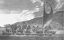
Priests traveling across Kealakekua Bay for first contact rituals. Each helmet is a gourd, with foliage and tapa strip decoration. A feather-surrounded akua is in the arms of the priest at the center of the engraving.

There have been changing views about initial Polynesian discovery and settlement of Hawai'i.[2] Radiocarbon dating in Hawai'i initially indicated a possible settlement as early as 124.[3][4] Patrick Vinton Kirch's books on Hawaiian archeology, standard textbooks, date the first Polynesian settlements to about 300 with more recent suggestions by Kirch as late as 600. Other theories suggest dating as late as 700 to 800.[2]

In 2010 researchers announced new findings using revised, high-precision radiocarbon dating based on more reliable samples than were previously used in many dating studies.[5] This new data indicates that the period of eastern and northern Polynesian colonization took place much later, in a shorter time frame of two waves: the "earliest in the Society Islands c. 1025 – 1120, four centuries later than previously assumed; then after 70–265 y, dispersal continued in one major pulse to all remaining islands c. 1190 – 1290."[1] According to this research, settlement of the Hawaiian Islands took place circa 1219–1266.[1] This rapid colonization is believed to account for the "remarkable uniformity of East Polynesia culture, biology and language."[1]

According to Hawaiian mythology, there were other settlers in Hawaiʻi, peoples who were forced back into remote valleys by newer arrivals. They claim that stories about menehune, little people who built heiau and fishponds, prove the existence of ancient peoples who settled the islands before the Hawaiians.[6]

Settlement

The colonists brought along with them clothing, plants (called "canoe plants") and livestock and established settlements along the coasts and larger valleys. Upon their arrival, the settlers grew kalo (taro), maiʻa (banana), niu (coconut), ulu (breadfruit), and raised puaʻa (pork), moa (chicken), and ʻīlio (poi dog), although these meats were eaten less often than fruits, vegetables, and seafood. Popular condiments included pa'akai (salt), ground kukui nut, limu (seaweed), and ko (sugarcane) which was used as both a sweet and a medicine.[7] In addition to the foods they brought, the settlers also acquired ʻuala (sweet potato), which has yet to be adequately explained, as the plant originates in South America. A few researchers have argued that the presence of the sweet potato in the ancient Hawaiian diet is mysterious[citation needed].

The Pacific rat accompanied humans on their journey to Hawaiʻi. David Burney argues that humans, along with the vertebrate animals they brought with them (pigs, dogs, chickens and rats), caused many native species of birds, plants and large land snails to become extinct in the process of colonization.[8]

Estuaries and streams were adapted into fishponds by early Polynesian settlers, as long ago as 500 CE or earlier.[9] Packed earth and cut stone were used to create habitat, making ancient Hawaiian aquaculture among the most advanced of the original peoples of the Pacific.[10] A notable example is the Menehune Fishpond dating from at least 1,000 years ago, at Alekoko. At the time of Captain James Cook's arrival, there were at least 360 fishponds producing 2,000,000 pounds (900,000 kg) of fish per year.[9] Over the course of the last millennium, Hawaiians undertook "large-scale canal-fed pond field irrigation" projects for kalo (taro) cultivation.[11]

As soon as they arrived, the new settlers built hale (homes) and heiau (temples). Archaeologists currently believe that the first settlements were on the southern end of the Big Island of Hawaiʻi and that they quickly extended northwards, along the seacoasts and the easily accessible river valleys. As the population increased, settlements were made further inland. At this time, with the islands being so small, the population was very dense. Before European contact, the population had reached somewhere in the range of 200,000 to 1,000,000 people. After contact with the Europeans, however, the population steeply dropped due to various diseases including smallpox.[12]

Village

Hāpaialiʻi and Keʻeku Heiau

A traditional town of ancient Hawaiʻi included several structures. Listed in order of importance:
  • Heiau, temple to the gods. There were two major types. The agricultural mapele type was dedicated to Lono, and could be built by the nobility, priests, and land division chiefs, and whose ceremonies were open to all. The second type, luakini, were large war temples, where animal and human sacrifices were made. They were built on high-rising stone terraces and adorned with wood and stone carved idols. A source of great mana or divine power, the luakini could only be entered by aliʻi, the king, important chiefs and nobility, and kahuna who were members of the priesthood.[13]
  • Hale aliʻi, the house of the chief. It was used as a residence for the high chief and meeting house of the lesser chiefs. It was always built on a raised stone foundation to represent high social standing. Kāhili, or feather standards, were placed outside to signify royalty. Women and children were banned from entering.
  • Hale pahu, the house of the sacred hula instruments. It held the pahu drums. It was treated as a religious space as hula was a religious activity in honor of the goddess Laka.
  • Hale papaʻa, the house of royal storage. It was built to store royal implements including fabrics, prized nets and lines, clubs, spears and other weapons.
  • Hale ulana, the house of the weaver. It was the house where craftswomen would gather each day to manufacture the village baskets, fans, mats and other implements from dried pandanus leaves called lauhala.
  • Hale mua, the men's eating house. It was considered a sacred place because it was used to carve stone idols of ʻaumakua or ancestral gods. Men and women could not eat with each other for fear that men were vulnerable while eating to have their mana, or divine spirit, stolen by women. Women ate at their own separate eating house called the hale ʻaina. The design was meant for the men to be able to enter and exit quickly.
  • Hale waʻa, the house of the canoe. It was built along the beaches as a shelter for their fishing vessels. Hawaiians also stored koa logs used to craft the canoes.
  • Hale lawaiʻa, the house of fishing. It was built along the beaches as a shelter for their fishing nets and lines. Nets and lines were made by a tough rope fashioned from woven coconut husks. Fish hooks were made of human, pig or dog bone. Implements found in the hale lawaiʻa were some of the most prized possessions of the entire village.
  • Hale noho, the living house. It was built as sleeping and living quarters for the Hawaiian family unit.
  • Imu, the communal earth oven. Dug in the ground, it was used to cook the entire village's food including puaʻa or pork. Only men cooked using the imu.

Caste system

18th century Hawaiian helmet and cloak, signs of royalty.

Ancient Hawaiʻi was a caste society developed from Polynesians. The main classes were:
  • Aliʻi. This class consisted of the high and lesser chiefs of the realms. They governed with divine power called mana.
  • Kahuna. Priests conducted religious ceremonies, at the heiau and elsewhere. Professionals included master carpenters and boatbuilders, chanters, dancers, genealogists, physicians and healers.
  • Makaʻāinana. Commoners farmed, fished, and exercised the simpler crafts. They labored not only for themselves and their families, but to support the chiefs and kahuna.
  • Kauwā. They are believed to have been war captives or the descendants of war captives. Marriage between higher castes and the kauwā was strictly forbidden. The kauwā worked for the chiefs and were often used as human sacrifices at the luakini heiau. (They were not the only sacrifices; law-breakers of all castes or defeated political opponents were also acceptable as victims.).

Education

Hawaiian youth learned life skills and religion at home, often with grandparents. For "bright" children [14] a system of apprenticeship existed in which very young students would begin learning a craft or profession by assisting an expert, or kahuna. As spiritual powers were perceived by Hawaiians to imbue all of nature, experts in many fields of work were known as kahuna, a term commonly understood to mean priest.[15] The various types of kahuna passed on knowledge of their profession, be it in "genealogies, or mele, or herb medicine, or canoe building, or land boundaries,"[16] etc. by involving and instructing apprentices in their work. More formal schools existed for the study of hula, and likely for the study of higher levels of sacred knowledge.
The kahuna took the apprentice into his household as a member of the family, although often "the tutor was a relative".[14] During a religious "graduation" ceremony, "the teacher consecrated the pupil, who thereafter was one with the teacher in psychic relationship as definite and obligatory as blood relationship." [14] Like the children learning from their grandparents, children who were apprentices learned by watching and participating in daily life. Children were discouraged from asking questions in traditional Hawaiian culture.

Land tenure

In Hawaiian ideology, one does not "own" the land, but merely dwells on it. The belief was that both the land and the gods were immortal. This then informed the belief that land was also godly, and therefore above mortal and ungodly humans, and humans therefore could not own land. The Hawaiians thought that all land belonged to the gods (akua).

The aliʻi were believed to be "managers" of land. That is, they controlled those who worked on the land, the makaʻāinana.

On the death of one chief and the accession of another, lands were re-apportioned—some of the previous "managers" would lose their lands, and others would gain them. Lands were also re-apportioned when one chief defeated another and re-distributed the conquered lands as rewards to his warriors.

In practice, commoners had some security against capricious re-possession of their houses and farms. They were usually left in place, to pay tribute and supply labor to a new chief, under the supervision of a new konohiki, or overseer.

This system of land tenure is similar to the feudal system prevalent in Europe during the Middle Ages.

The ancient Hawaiians had the ahupuaʻa as their source of water management. Each ahupuaʻa had a sub-division of land from the mountain to the sea. The Hawaiians used the water from the rain that ran through the mountains as a form of irrigation. Hawaiians also settled around these parts of the land because of the farming that was done.[17]

Religion and the Kapu system

Religion held ancient Hawaiian society together, affecting habits, lifestyles, work methods, social policy and law. The legal system was based on religious kapu, or taboos. There was a correct way to live, to worship, and even to eat. Examples of kapu included the provision that men and women could not eat together (ʻAikapu religion). Fishing was limited to specified seasons of the year. The shadow of the aliʻi must not be touched as it was stealing his mana.
The rigidity of the kapu system might have come from a second wave of migrations in 1000–1300 from which different religions and systems were shared between Hawaiʻi and the Society Islands. Hawaiʻi would have been influenced by the Tahitian chiefs, the kapu system would have become stricter, and the social structure would have changed. Human sacrifice would have become a part of their new religious observance, and the aliʻi would have gained more power over the counsel of experts on the islands.[18]

Kapu was derived from traditions and beliefs from Hawaiian worship of gods, demigods and ancestral mana. The forces of nature were personified as the main gods of (God of War), Kāne (God of Light and Life), Kanaloa (God of Death), and Lono (God of peace and growth). Well-known lesser gods include Pele (Goddess of Fire) and her sister Hiʻiaka (Goddess of Dance). In a famous creation story, the demigod Māui fished the islands of Hawaiʻi from the sea after a little mistake he made on a fishing trip. From Haleakalā, Māui ensnared the sun in another story, forcing him to slow down so there were equal periods of darkness and light each day.

The Hawaiian mystical worldview allows for different gods and spirits to imbue any aspect of the natural world.[19] From this mystical perspective, in addition to his presence in lightning and rainbows, the God of Light and Life, Kāne, can be present in rain and clouds and a peaceful breeze (typically the "home" of Lono).

Although all food and drink had religious significance to the ancient Hawaiians, special cultural emphasis was placed on ʻawa (kava) due to its narcotic properties. This root-based beverage, a psychoactive and a relaxant, was used to consecrate meals and commemorate ceremonies. It is often referred to in Hawaiian chant.[20] Different varieties of the root were used by different castes, and the brew served as an "introduction to mysticism".[19]

Chiefs

The four biggest islands, the island of Hawaiʻi, Maui, Kauaʻi and Oʻahu were generally ruled by their own aliʻi nui (supreme ruler) with lower ranking subordinate chiefs called aliʻi ʻaimoku, ruling individual districts with land agents called konohiki.
All these dynasties were interrelated and regarded all the Hawaiian people (and possibly all humans) as descendants of legendary parents, Wākea (symbolizing the air) and his wife Papa (symbolizing the earth). Up to the late eighteenth century, the island of Hawaiʻi had been ruled by one line descended from Umi-a-Liloa. At the death of Keaweʻīkekahialiʻiokamoku, a lower ranking chief, Alapainui, overthrew the two sons of the former ruler who were next in line as the island's aliʻi nui.

Assuming five to ten generations per century, the Aliʻi ʻAimoku dynasties were around three to six centuries old at 1800 CE. The Tahitian settlement of the Hawaiian islands is believed to have taken place in the thirteenth century. The aliʻi and other social castes were presumably established during this period.

Subsistence economy

The ancient Hawaiian economy became complex over time. People began to specialize in specific skills. Generations of families became committed to certain careers: roof thatchers, house builders, stone grinders, bird catchers who would make the feather cloaks of the aliʻi, canoe builders. Soon, entire islands began to specialize in certain skilled trades. Oʻahu became the chief kapa (tapa bark cloth) manufacturer. Maui became the chief canoe manufacturer. The island of Hawaiʻi exchanged bales of dried fish.

First recorded European contact

European contact with the Hawaiian islands marked the beginning of the end of the ancient Hawaiʻi period. In 1778, British Captain James Cook landed first on Kauaʻi, then sailed southwards to observe and explore the other islands in the chain.

When he first arrived at Kealakekua Bay in 1779, some of the natives believed Cook was their god Lono. Cook's mast and sails coincidentally resembled the emblem (a mast and sheet of white kapa) that symbolized Lono in their religious rituals; the ships arrived during the Makahiki season dedicated to Lono.

Captain Cook was eventually killed during a violent confrontation and left behind on the beach by his retreating sailors. The British demanded that his body be returned, but the Hawaiians had already performed funerary rituals of their tradition.[21]

Within a few decades Kamehameha I used European warfare tactics and some firearms and cannon to unite the islands into the Kingdom of Hawaiʻi.

‘Atomic sandwich’ computing material uses 100 times less energy

Could lead to reduction of the forecast 50 percent of global energy consumption by electronics by 2030
October 21, 2016
Original link:  http://www.kurzweilai.net/atomic-sandwich-computing-material-uses-100-times-less-energy
New magnetoelectric multiferroic material operates at 100 times lower power (credit: Julia A. Mundy/Nature)

Lawrence Berkeley National Laboratory scientists have developed a new “magnetoelectric multiferroic*” material that could lead to a new generation of computing devices with more computing power while consuming a fraction of the energy that today’s electronics require.

Electronics could be half of our total global energy consumption by 2030

“Electronics are the fastest-growing consumer of energy worldwide,” said Ramamoorthy Ramesh, associate laboratory director for energy technologies at Lawrence Berkeley National Laboratory.
“Today, about five percent of our total global energy consumption is spent on electronics, and that’s projected to grow to 40–50 percent by 2030 if we continue at the current pace and if there are no major advances in the field that lead to lower energy consumption.”

Global or world energy consumption is the total energy used by all of human civilization. The U.S. Energy Information Administration estimates that in 2013, world energy consumption was 157,481 terawatt hours (TWh), mainly from polluting expendables — oil, coal, and natural gas.

The new material, which combines electrical and magnetic properties at room temperature, could help reduce this consumption in the future.

Room-temperature multiferroics

The newly developed material sandwiches together individual layers of atoms, producing a thin film with magnetic polarity that can be “flipped” from positive to negative or vice versa with small pulses of electricity.

In the future, device makers could use this property to store digital 0’s and 1’s, the binary backbone that underpins computing devices.

“Before this work, there was only one other room-temperature multiferroic whose magnetic properties could be controlled by electricity,” said John Heron, assistant professor in the Department of Materials Science and Engineering at the University of Michigan, who worked on the material with researchers at Cornell University. “That electrical control is what excites electronics makers, so this is a huge step forward.”

100 times less power required

Room-temperature multiferroics are a hotly pursued goal in the electronics field because they require much less power to read and write data than today’s semiconductor-based devices. In addition, they are nonvolatile (their data doesn’t vanish when the power is shut off).

Those properties could enable devices that require only brief pulses of electricity instead of the constant stream that’s needed for current electronics, resulting in using an estimated 100 times less energy.

To create the new material, the researchers started with thin, atomically precise films of hexagonal lutetium iron oxide (LuFeO3), a material known to be a robust ferroelectric, but not strongly magnetic. Lutetium iron oxide consists of alternating monolayers of lutetium oxide and iron oxide. They then used a technique called molecular-beam epitaxy (which takes place in a high vacuum) to add one extra monolayer of iron oxide to every 10 atomic repeats of the single-single monolayer pattern.

“We were essentially spray painting individual atoms of iron, lutetium and oxygen to achieve a new atomic structure that exhibits stronger magnetic properties,” said Darrell Schlom, a materials science and engineering professor at Cornell and senior author of a paper on the work recently published in Nature.

The result was a new material that combines a phenomenon in lutetium oxide called “planar rumpling” with the magnetic properties of iron oxide to achieve multiferroic properties at room temperature.**

While Heron believes a viable multiferroic device is likely several years off, the work puts the field closer to its goal of devices that continue the computing industry’s speed improvements while consuming less power — replacing current silicon-based technology.

The research was published in a paper in the Sept. 22 issue of Nature. It was supported by the Department of Energy’s Office of Science.

* The magnetoelectric effect is the phenomenon of inducing magnetic or electric polarization by applying an external electric or magnetic field. “Ferroics” is the generic name given to the study of iron-based ferromagnetsferroelectrics, and ferroelastics. These materials exhibit large changes in physical characteristics that occur when phase transitions (such as paramagnetic, or temporary magnetism, to ferromagnetic, or permanent magnetism) take place around some critical temperature value. Multiferroics exhibit more than one ferroic property simultaneously.

** Heron explains that the lutetium exhibits atomic-level displacements called rumples. Visible under an electron microscope, the rumples enhance the magnetism in the material, allowing it to persist at room temperature. The rumples can be moved by applying an electric field, and are enough to nudge the magnetic field in the neighboring layer of iron oxide from positive to negative or vice versa, creating a material whose magnetic properties can be controlled with electricity — a “magnetoelectric multiferroic.”


Abstract of Atomically engineered ferroic layers yield a room-temperature magnetoelectric multiferroic

Materials that exhibit simultaneous order in their electric and magnetic ground states hold promise for use in next-generation memory devices in which electric fields control magnetism. Such materials are exceedingly rare, however, owing to competing requirements for displacive ferroelectricity and magnetism. Despite the recent identification of several new multiferroic materials and magnetoelectric coupling mechanisms, known single-phase multiferroics remain limited by antiferromagnetic or weak ferromagnetic alignments, by a lack of coupling between the order parameters, or by having properties that emerge only well below room temperature, precluding device applications2. Here we present a methodology for constructing single-phase multiferroic materials in which ferroelectricity and strong magnetic ordering are coupled near room temperature. Starting with hexagonal LuFeO3—the geometric ferroelectric with the greatest known planar rumpling—we introduce individual monolayers of FeO during growth to construct formula-unit-thick syntactic layers of ferrimagnetic LuFe2O4 within the LuFeO3 matrix, that is, (LuFeO3)m/(LuFe2O4)1 superlattices. The severe rumpling imposed by the neighbouring LuFeO3 drives the ferrimagnetic LuFe2O4 into a simultaneously ferroelectric state, while also reducing the LuFe2O4 spin frustration. This increases the magnetic transition temperature substantially—from 240 kelvin for LuFe2O4to 281 kelvin for (LuFeO3)9/(LuFe2O4)1. Moreover, the ferroelectric order couples to the ferrimagnetism, enabling direct electric-field control of magnetism at 200 kelvin. Our results demonstrate a design methodology for creating higher-temperature magnetoelectric multiferroics by exploiting a combination of geometric frustration, lattice distortions and epitaxial engineering.

Polynesian navigation

From Wikipedia, the free encyclopedia
 
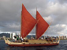
Hokule'a, Hawaiian double-hulled canoe sailing off Honolulu, 2009.
 
Hawaiian navigators sailing multi-hulled canoe, c. 1781

Traditional Polynesian navigation was used for thousands of years to make long voyages across thousands of miles of the open Pacific Ocean. Navigators travelled to small inhabited islands using wayfinding techniques and knowledge passed by oral tradition from master to apprentice, often in the form of song. Generally each island maintained a guild of navigators who had very high status; in times of famine or difficulty they could trade for aid or evacuate people to neighboring islands. As of 2014, these traditional navigation methods are still taught in the Polynesian outlier of Taumako Island in the Solomons.

Polynesian navigation used some navigational instruments, which predate and are distinct from the machined metal tools used by European navigators (such as the sextant, first produced in 1730; the sea astrolabe, from around late 15th century; and the marine chronometer, invented in 1761). However, they also relied heavily on close observation of sea sign and a large body of knowledge from oral tradition.[1]

Both wayfinding techniques and outrigger canoe construction methods have been kept as guild secrets, but in the modern revival of these skills, they are being recorded and published.

History

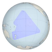
A projection of the Polynesian triangle on the globe.

Between about 3000 and 1000 BC speakers of Austronesian languages spread through the islands of Southeast Asia – almost certainly starting out from Taiwan,[2] as tribes whose natives were thought to have previously arrived from mainland South China about 8000 years ago – into the edges of western Micronesia and on into Melanesia. In the archaeological record there are well-defined traces of this expansion which allow the path it took to be followed and dated with a degree of certainty. In the mid-2nd millennium BC a distinctive culture appeared suddenly in north-west Melanesia, in the Bismarck Archipelago, the chain of islands forming a great arch from New Britain to the Admiralty Islands. This culture, known as Lapita, stands out in the Melanesian archeological record, with its large permanent villages on beach terraces along the coasts. Particularly characteristic of the Lapita culture is the making of pottery, including a great many vessels of varied shapes, some distinguished by fine patterns and motifs pressed into the clay. Within a mere three or four centuries between about 1300 and 900 BC, the Lapita culture spread 6000 km further to the east from the Bismarck Archipelago, until it reached as far as Tonga and Samoa.[3] Lapita pottery persisted in places such as Samoa, Tonga, and Fiji for many years after its upbringing to Western and Central Polynesia. However, pottery-making died out in most of Polynesia due to the scarcity of clay on the islands.[4] In this region, the distinctive Polynesian culture developed. The Polynesians are then believed to have spread eastward from the Samoan Islands into the Marquesas, the Society Islands, the Hawaiian Islands and Easter Island; and south to New Zealand. The pattern of settlement also extended to the north of Samoa to the Tuvaluan atolls, with Tuvalu providing a stepping stone to migration into the Polynesian Outlier communities in Melanesia and Micronesia.[5][6][7]

Canoes and navigation

The Polynesians encountered nearly every island within the vast Polynesian Triangle using outrigger canoes or double-hulled canoes. The double-hulled canoes were two large hulls, equal in length, and lashed side by side. The space between the paralleled canoes allowed for storage of food, hunting materials, and nets when embarking on long voyages.[8] Polynesians used strategic and natural navigation aides such as the stars, ocean currents, and wind patterns.[9]

Navigational devices

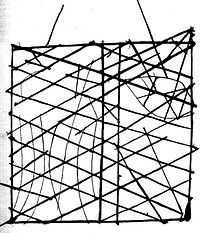
Polynesian navigation device showing directions of winds, waves and islands, c. 1904

There are numerous traditional Polynesian devices used for navigating and/or teaching navigation. These include charts, spatial representations of islands and the conditions around them, and navigational instruments, such as those for measuring the elevation of celestial objects. They also include non-physical devices such as songs and stories for memorizing the properties of stars, islands, and navigational routes.

Navigational techniques

Navigation relies heavily on constant observation and memorization; you must constantly be aware of your surroundings. You cannot simply look up at the stars and know where you are. You are only able to know where you are if you are able to memorize where you have sailed from. The sun was the main guide for voyagers because they could follow its exact points as it rose and set; then, at night time they'd switch to using the stars rising and setting points. With constant observation, comes the knowledge of knowing and remembering the speed of your canoe (when it speeds up and slows down), what direction you are facing, and what time of the day or night it is. In the ancient days, they did not have watches, compasses or speedometers but they had their minds and the ability to memorize their surroundings. When there are no stars because of a cloudy night or during midday, the navigator would use the winds and swells to guide them.[10] Polynesian navigators employed a whole range of techniques including use of the stars, the movement of ocean currents and wave patterns, the air and sea interference patterns caused by islands and atolls, the flight of birds, the winds and the weather.[11]

Bird observation

Certain seabirds such as the White tern and Noddy tern feed on fish in the morning and return to rest on land at night time. Navigators use these birds to guide them to land by following where the birds are flying from in the morning which they are flying so they would lead them to the land. Birds habits change during nesting season which is another thing navigators must be mindful of when voyaging. Generally speaking, if a navigator can see a large group of birds, that is a much more reliable sign for land than following one, two or a small group of birds.[12] Harold Gatty suggested that long-distance Polynesian voyaging followed the seasonal paths of bird migrations. In "The Raft Book",[13] a survival guide he wrote for the U.S. military during World War II, Gatty outlined various Polynesian navigation techniques Allied sailors or aviators wrecked at sea could use to find their way to land. There are some references in their oral traditions to the flight of birds and some say that there were range marks onshore pointing to distant islands in line with the West Pacific Flyway. A voyage from Tahiti, the Tuamotus or the Cook Islands to New Zealand might have followed the migration of the long-tailed cuckoo (Eudynamys taitensis) just as the voyage from Tahiti to Hawaiʻi would coincide with the track of the Pacific golden plover (Pluvialis fulva) and the bristle-thighed curlew (Numenius tahitiensis). It is also believed that Polynesians employed shore-sighting birds as did many seafaring peoples. One theory is that they would have taken a frigatebird (Fregata) with them. These birds refuse to land on the water as their feathers will become waterlogged making it impossible to fly. When the voyagers thought they were close to land they may have released the bird, which would either fly towards land or else return to the canoe.[11]

Navigation by the stars

A photograph of a recreation of the star compass of Mau Piailug depicted with shells on sand, with Satawalese (See Trukic languages) text labels, as described and translated by the Polynesian Voyaging Society.[14] Shown here north-up. See annotations on Commons.

The positions of the stars helped guide Polynesians through their voyaging routes. Stars- as opposed to planets are able to hold a steady position year-round. The only thing that changes is the time the star rises which changes seasonally. Polynesian voyagers would follow stars near the horizon whether they were just rising or about to set and they used these specific stars for guidance. These stars were used to set the direction for their canoe up until the point when those stars rise too high and are no longer easy to follow. Once the star they've used to guide them rises too high, they use the next star that rises from the previous stars exact rising point to guide them next. The canoes latitude and the course being followed determines how many stars the navigator will need to get him to his destination.[12] For navigators near the equator celestial navigation is simplified since the whole celestial sphere is exposed. Any star that passes the zenith (overhead) is on the celestial equator, the basis of the equatorial coordinate system. Each star has a specific declination, and when they rise or set, they give a bearing for navigation. Stars are learned by compass point, making a star compass (star compasses list ~150 stars, in some systems[15]). A simplified compass might list only a couple of dozen stars.[16] For example, in the Caroline Islands Mau Piailug taught natural navigation using a star compass diagrammed here. The development of "sidereal compasses" has been studied[17] and theorized to have developed from an ancient pelorus.[11]

The Polynesians also took measurements of stellar elevation to determine their latitude. The latitudes of specific islands were also known, and the technique of "sailing down the latitude" was used.

Swell

The Polynesians also use wave and swell formations to navigate. Many of the habitable areas of the Pacific Ocean are groups of islands (or atolls) in chains hundreds of kilometers long. Island chains have predictable effects on waves and on currents. Navigators who lived within a group of islands would learn the effect various islands had on their shape, direction, and motion and would have been able to correct their path in accordance with the changes they perceived. When they arrived in the vicinity of a chain of islands they were unfamiliar with, they may have been able to transfer their experience and deduce that they were nearing a group of islands. Once they had arrived fairly close to a destination island, they would have been able to pinpoint its location by sightings of land-based birds, certain cloud formations, as well as the reflections shallow water made on the undersides of clouds. It is thought that the Polynesian navigators may have measured the time it took to sail between islands in "canoe-days" or a similar type of expression.[11] The energy that is transferred from the wind to the sea are wind waves. The waves that are created when the energy travels down away from the source area (like ripples) are known as swell. When the winds are strong at the source area, the swell is larger. The longer the wind blows, the longer the swell lasts. Because the swells of the ocean can remain consistent for days, navigators relied on them to carry their canoe in a straight line from one house on the star compass to a house of the same name on the opposite side of the horizon. Navigators were not always able to see stars; because of this, they relied on the swells of the ocean. Swell patterns are a way more reliable method of navigation than the actual waves which are determined by the local winds. Swells move in a straight direction which makes it easier for the navigator to determine whether the canoe is heading in the correct direction.[18]

Routes

Tupaia's chart of Polynesia within 3200km of Ra'iatea. 1769, preserved in the British Museum.

On his first voyage of Pacific exploration, Captain James Cook had the services of a Polynesian navigator, Tupaia, who drew a chart of the islands within a 2,000 miles (3,200 km) radius (to the north and west) of his home island of Ra'iatea. Tupaia had knowledge of 130 islands and named 74 on his chart.[19] Tupaia had navigated from Ra'iatea in short voyages to 13 islands. He had not visited western Polynesia, as since his grandfather's time the extent of voyaging by Raiateans had diminished to the islands of eastern Polynesia. His grandfather and father had passed to Tupaia the knowledge as to the location of the major islands of western Polynesia and the navigation information necessary to voyage to Fiji, Samoa and Tonga.[20] Tupaia was hired by Joseph Banks, the ship's naturalist, who wrote that Cook ignored Tupaia's chart and his skills as a navigator.[21]

Subantarctic and Antarctica

Antarctica and surrounding islands, showing the Auckland Islands just above (south of) New Zealand, at the center bottom of the image

There is academic debate on the furthest southern extent of Polynesian expansion.

There is material evidence of Polynesian visits to some of the subantarctic islands to the south of New Zealand, which are outside Polynesia proper. Remains of a Polynesian settlement dating back to the 13th century were found on Enderby Island in the Auckland Islands.[22][23][24][25] Descriptions of a shard of early Polynesian pottery buried on the Antipodes Islands[26] are unsubstantiated, and the Museum of New Zealand Te Papa Tongarewa, where it was supposedly stored, has stated that "The Museum has not been able to locate such a shard in its collection, and the original reference[27] to the object in the Museum's collection documentation indicates no reference to Polynesian influences."

Oral history describes Ui-te-Rangiora, around the year 650, leading a fleet of Waka Tīwai south until they reached, "a place of bitter cold where rock-like structures rose from a solid sea".[28] The brief description might match the Ross Ice Shelf or possibly the Antarctic mainland,[29] but may be a description of icebergs surrounded by sea Ice found in the Southern Ocean.[30][31] The account also describes snow.

Pre-Columbian contact with the Americas

In the mid-20th century, Thor Heyerdahl proposed a new theory of Polynesian origins (one which did not win general acceptance), arguing that the Polynesians had migrated from South America on balsa-log boats.[32][33]
The presence in the Cook Islands of sweet potato that is a plant native to the Americas (called kūmara in Māori), which have been radiocarbon-dated to 1000 CE, has been cited as evidence that Americans could have traveled to Oceania. The current thinking is that sweet potato was brought to central Polynesia circa 700 CE and spread across Polynesia from there, possibly by Polynesians who had traveled to South America and back.[34] An alternative explanation posits biological dispersal; plants and/or seeds could float across the Pacific without any human contact.[35]

A 2007 study published in the Proceedings of the National Academy of Sciences examined chicken bones at El Arenal near the Arauco Peninsula, Arauco Province, Chile. The results suggested Oceania-to-America contact. Chickens originated in southern Asia and the Araucana breed of Chile was thought to have been brought by Spaniards around 1500. However, the bones found in Chile were radiocarbon-dated to between 1304 and 1424, well before the documented arrival of the Spanish. DNA sequences taken were exact matches to those of chickens from the same period in American Samoa and Tonga, both over 5000 miles (8000 kilometers) away from Chile. The genetic sequences were also similar to those found in Hawaiʻi and Easter Island, the closest island at only 2500 miles (4000 kilometers), and unlike any breed of European chicken.[36][37][38] Although this initial report suggested a Polynesian pre-Columbian origin a later report looking at the same specimens concluded:
A published, apparently pre-Columbian, Chilean specimen and six pre-European Polynesian specimens also cluster with the same European/Indian subcontinental/Southeast Asian sequences, providing no support for a Polynesian introduction of chickens to South America. In contrast, sequences from two archaeological sites on Easter Island group with an uncommon haplogroup from Indonesia, Japan, and China and may represent a genetic signature of an early Polynesian dispersal. Modeling of the potential marine carbon contribution to the Chilean archaeological specimen casts further doubt on claims for pre-Columbian chickens, and definitive proof will require further analyses of ancient DNA sequences and radiocarbon and stable isotope data from archaeological excavations within both Chile and Polynesia.[39]
In the last 20 years, the dates and anatomical features of human remains found in Mexico and South America have led some archaeologists[who?] to propose that those regions were first populated by people who crossed the Pacific several millennia before the Ice Age migrations; according to this theory, these would have been either eliminated or absorbed by the Siberian immigrants. However, current archaeological evidence for human migration to and settlement of remote Oceania (i.e., the Pacific Ocean eastwards of the Solomon Islands) is dated to no earlier than approximately 3,500 BP;[40] trans-Pacific contact with the Americas coinciding with or pre-dating the Beringia migrations of at least 11,500 BP is highly problematic, except for movement along intercoastal routes.

Recently, linguist Kathryn A. Klar of University of California, Berkeley and archaeologist Terry L. Jones of California Polytechnic State University have proposed contacts between Polynesians and the Chumash and Gabrielino of Southern California, between 500 and 700. Their primary evidence consists of the advanced sewn-plank canoe design, which is used throughout the Polynesian Islands, but is unknown in North America – except for those two tribes. Moreover, the Chumash word for "sewn-plank canoe", tomolo'o, may have been derived from kumulaa'au, a Hawaiian word meaning "useful tree".

In 2008, an expedition starting on the Philippines sailed two modern Wharram-designed catamarans loosely based on a Polynesian catamaran found in Auckland Museum New Zealand. The boats were built in the Philippines by an experienced boat builder to Wharram designs using modern strip plank with epoxy resin glue built over plywood frames. The catamarans had modern Dacron sails, Terylene stays and sheets with modern roller blocks. Wharram says he used Polynesian navigation to sail along the coast of Northern New Guinea and then sailed 150 miles to an island for which he had modern charts, proving that it is possible to sail a modern catamaran along the path of the Lapita Pacific migration.[41] Unlike many other modern Polynesian "replica" voyages the Wharram catamarans were not towed or escorted by a modern vessel with modern GPS navigation system, nor were they fitted with a motor.

Polynesian contact with the prehispanic Mapuche culture in central-south Chile has been suggested because of apparently similar cultural traits, including words like toki (stone axes and adzes), hand clubs similar to the Māori wahaika, the sewn-plank canoe as used on Chiloe island, the curanto earth oven (Polynesian umu) common in southern Chile, fishing techniques such as stone wall enclosures, a hockey-like game, and other potential parallels. Some strong westerlies and El Niño wind blow directly from central-east Polynesia to the Mapuche region, between Concepcion and Chiloe. A direct connection from New Zealand is possible, sailing with the Roaring Forties. In 1834, some escapees from Tasmania arrived at Chiloe Island after sailing for 43 days.[42][43]

Revival

The first settlers who sailed to the Hawaiian Islands are said to have arrived as early as 400 C.E by Polynesians from the Marquesas Islands. Captain James Cook was the first European to arrive to the island of Kaua’i in 1778. He returned a year later and was killed in an altercation with natives at Kealakekua Bay. In 1973, Ben Finney established the Polynesian Voyaging Society to test the contentious question of how Polynesians found their islands. The team claimed to be able to replicate ancient Hawaiian double-hulled canoes capable of sailing across the ocean using strictly traditional voyaging techniques.[44] In 1980, a Hawaiian named Nainoa Thompson invented a new method of non-instrument navigation (called the "modern Hawaiian wayfinding system"), enabling him to complete the voyage from Hawaiʻi to Tahiti and back. In 1987, a Māori named Matahi Whakataka (Greg Brightwell) and his mentor Francis Cowan sailed from Tahiti to Aotearoa without instruments.

In New Zealand, a leading Māori navigator and ship builder is Hector Busby who was also inspired and influenced by Nainoa Thompson and Hokulea's voyage there in 1985.[45][46]

Post-colonial research history

Navigator Mau Piailug (1932–2010) of Satawal island, Micronesia

Knowledge of the traditional Polynesian methods of navigation was widely lost after contact with and colonization by Europeans. This caused debates over the reasons for the presence of the Polynesians in such isolated and scattered parts of the Pacific. According to Andrew Sharp, the explorer Captain James Cook, already familiar with Charles de Brosses's accounts of large groups of Pacific islanders who were driven off course in storms and ended up hundreds of miles away with no idea where they were, encountered in the course of one of his own voyages a castaway group of Tahitians who had become lost at sea in a gale and blown 1000 miles away to the island of Atiu. Cook wrote that this incident "will serve to explain, better than the thousand conjectures of speculative reasoners, how the detached parts of the earth, and, in particular, how the South Seas, may have been peopled".[47]

By the late 19th century to the early 20th century, a more generous view of Polynesian navigation had come into favor, creating a much romanticized view of their seamanship, canoes, and navigational expertise. Late 19th and early 20th centuries writers such as Abraham Fornander and Percy Smith told of heroic Polynesians migrating in great coordinated fleets from Asia far and wide into present-day Polynesia.[33]

Another view was presented by Andrew Sharp who challenged the "heroic vision" hypothesis, asserting instead that Polynesian maritime expertise was severely limited in the field of exploration and that as a result the settlement of Polynesia had been the result of luck, random island sightings, and drifting, rather than as organized voyages of colonization. Thereafter the oral knowledge passed down for generations allowed for eventual mastery of traveling between known locations.[48] Sharp's reassessment caused a huge amount of controversy and led to a stalemate between the romantic and the skeptical views.[33]
 
Doubled hulled vaka in Rarotonga, 2010.

By the mid-to-late 1960s it was time for a new hands-on approach. Anthropologist David Lewis sailed his catamaran from Tahiti to New Zealand using stellar navigation without instruments.[49] Anthropologist and historian Ben Finney built Nalehia, a 40-foot (12 m) replica of a Hawaiian double canoe. Finney tested the canoe in a series of sailing and paddling experiments in Hawaiian waters. At the same time, ethnographic research in the Caroline Islands in Micronesia brought to light the fact that traditional stellar navigational methods were still very much in everyday use there. The building and testing of proa canoes (wa) inspired by traditional designs, the harnessing of knowledge from skilled Micronesians, as well as voyages using stellar navigation, allowed practical conclusions about the seaworthiness and handling capabilities of traditional Polynesian canoes and allowed a better understanding of the navigational methods that were likely to have been used by the Polynesians and of how they, as people, were adapted to seafaring.[50] Recent re-creations of Polynesian voyaging have used methods based largely on Micronesian methods and the teachings of a Micronesian navigator, Mau Piailug.[51]

In accordance with Polynesian oral tradition, the geography of Polynesian navigation pathways are said to resemble the geometric qualities of an octopus with head centred on Ra'iātea (French Polynesia) and tentacles spread out across the Pacific.[52] In oral tradition the octopus is known by various names such as Taumata-Fe'e-Fa'atupu-Hau (Grand Octopus of Prosperity), Tumu-Ra'i-Fenua (Beginning-of-Heaven-and-Earth) and Te Wheke-a-Muturangi (The Octopus of Muturangi).

Geopark

From Wikipedia, the free encyclopedia https://en.wikipedia.org/wiki/Geo...