Geology (from the
Greek γῆ,
gē, i.e. "earth" and -λoγία,
-logia, i.e. "study of, discourse"
[1][2]) is an
earth science comprising the study of
solid Earth, the
rocks of which it is composed, and the processes by which they change. Geology can also refer generally to the study of the solid features of any
celestial body (such as the
geology of the Moon or
Mars).
Geology gives insight into the
history of the Earth by providing the primary evidence for
plate tectonics, the
evolutionary history of life, and
past climates. Geology is important for
mineral and
hydrocarbon exploration and exploitation, evaluating
water resources, understanding of
natural hazards, the remediation of
environmental problems, and for providing insights into past
climate change. Geology also plays a role in
geotechnical engineering and is a major
academic discipline.
§Geologic time

Geological time put in a diagram called a
geological clock, showing the relative lengths of the
eons of the Earth's history.
The geologic time scale encompasses the history of the Earth.
[3] It is bracketed at the old end by the dates of the earliest
Solar System material at 4.567
Ga,
[4] (gigaannum: billion years ago) and the age of the Earth at 4.54 Ga
[5][6] at the beginning of the informally recognized
Hadean eon. At the young end of the scale, it is bracketed by the present day in the
Holocene epoch.
§Important milestones
§Brief time scale
The following four timelines show the geologic time scale. The first shows the entire time from the formation of the Earth to the present, but this compresses the most recent eon. Therefore the second scale shows the most recent eon with an expanded scale. The second scale compresses the most recent era, so the most recent era is expanded in the third scale. Since the
Quaternary is a very short period with short epochs, it is further expanded in the fourth scale. The second, third, and fourth timelines are therefore each subsections of their preceding timeline as indicated by asterisks. The
Holocene (the latest
epoch) is too small to be shown clearly on the third timeline on the right, another reason for expanding the fourth scale. The Pleistocene (P) epoch. Q stands for the Quaternary period.

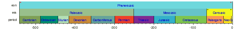


Millions of Years
§Relative and absolute dating
Geologists use a variety of methods to give both relative and absolute dates to geological events. They then use these dates to find the rates at which processes occur.
§Relative dating
Methods for
relative dating were developed when geology first emerged as a
formal science. Geologists still use the following principles today as a means to provide information about geologic history and the timing of geologic events.
The principle of Uniformitarianism states that the geologic processes observed in operation that modify the Earth's crust at present have worked in much the same way over geologic time.
[7] A fundamental principle of geology advanced by the 18th century Scottish physician and geologist
James Hutton, is that "the present is the key to the past." In Hutton's words: "the past history of our globe must be explained by what can be seen to be happening now."
[8]
The principle of intrusive relationships concerns crosscutting intrusions. In geology, when an
igneous intrusion cuts across a formation of
sedimentary rock, it can be determined that the igneous intrusion is younger than the sedimentary rock. There are a number of different types of intrusions, including stocks,
laccoliths,
batholiths,
sills and
dikes.
The principle of cross-cutting relationships pertains to the formation of
faults and the age of the sequences through which they cut. Faults are younger than the rocks they cut; accordingly, if a fault is found that penetrates some formations but not those on top of it, then the formations that were cut are older than the fault, and the ones that are not cut must be younger than the fault. Finding the key bed in these situations may help determine whether the fault is a
normal fault or a
thrust fault.
[9]
The principle of inclusions and components states that, with sedimentary rocks, if inclusions (or
clasts) are found in a formation, then the inclusions must be older than the formation that contains them. For example, in sedimentary rocks, it is common for gravel from an older formation to be ripped up and included in a newer layer. A similar situation with igneous rocks occurs when
xenoliths are found. These foreign bodies are picked up as
magma or lava flows, and are incorporated, later to cool in the matrix. As a result, xenoliths are older than the rock which contains them.

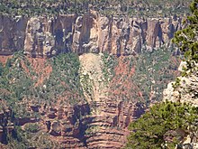
The
Permian through
Jurassic stratigraphy of the
Colorado Plateau area of southeastern
Utah is a great example of both Original Horizontality and the Law of Superposition. These strata make up much of the famous prominent rock formations in widely spaced protected areas such as
Capitol Reef National Park and
Canyonlands National Park. From top to bottom: Rounded tan domes of the
Navajo Sandstone, layered red
Kayenta Formation, cliff-forming, vertically jointed, red
Wingate Sandstone, slope-forming, purplish
Chinle Formation, layered, lighter-red
Moenkopi Formation, and white, layered
Cutler Formation sandstone. Picture from
Glen Canyon National Recreation Area, Utah.
The principle of original horizontality states that the deposition of sediments occurs as essentially horizontal beds. Observation of modern marine and non-marine sediments in a wide variety of environments supports this generalization (although
cross-bedding is inclined, the overall orientation of cross-bedded units is horizontal).
[9]
The principle of superposition states that a sedimentary rock layer in a tectonically undisturbed sequence is younger than the one beneath it and older than the one above it. Logically a younger layer cannot slip beneath a layer previously deposited. This principle allows sedimentary layers to be viewed as a form of vertical time line, a partial or complete record of the time elapsed from deposition of the lowest layer to deposition of the highest bed.
[9]
The principle of faunal succession is based on the appearance of fossils in sedimentary rocks. As organisms exist at the same time period throughout the world, their presence or (sometimes) absence may be used to provide a relative age of the formations in which they are found. Based on principles laid out by William Smith almost a hundred years before the publication of
Charles Darwin's
theory of evolution, the principles of succession were developed independently of evolutionary thought. The principle becomes quite complex, however, given the uncertainties of fossilization, the localization of fossil types due to lateral changes in habitat (
facies change in sedimentary strata), and that not all fossils may be found globally at the same time.
[10]
§Absolute dating
Geologists can also give precise absolute dates to geologic events. These dates are useful on their own and may also be used in conjunction with relative dating methods or to calibrate relative methods.
[11]
At the beginning of the 20th century, the large advance in geology was the ability to give precise absolute dates to geologic events through radioactive isotopes and other methods. The advent of radiometric dating changed the understanding of geologic time. Before, geologists could only use fossils to date sections of rock relative to one another. With isotopic dates,
absolute dating became possible, and these absolute dates could be applied to fossil sequences in which there was datable material, converting the old relative ages into new absolute ages.
For many geologic applications,
isotope ratios are measured in minerals that give the amount of time that has passed since a rock passed through its particular
closure temperature, the point at which different radiometric isotopes stop diffusing into and out of the
crystal lattice.
[12][13] These are used in
geochronologic and
thermochronologic studies. Common methods include
uranium-lead dating,
potassium-argon dating and
argon-argon dating, and
uranium-thorium dating. These methods are used for a variety of applications. Dating of lavas and ash layers can help to date stratigraphy and calibrate relative dating techniques. These methods can also be used to determine ages of
pluton emplacement. Thermochemical techniques can be used to determine temperature profiles within the crust, the uplift of mountain ranges, and paleotopography.
Fractionation of the
lanthanide series elements is used to compute ages since rocks were removed from the mantle.
Other methods are used for more recent events.
Optically stimulated luminescence and
cosmogenic radionucleide dating are used to date surfaces and/or erosion rates.
Dendrochronology can also be used for the dating of landscapes.
Radiocarbon dating is used for young
organic material.
§Geologic materials
The majority of geological data comes from research on solid Earth materials. These typically fall into one of two categories: rock and unconsolidated material.
§Rock
This schematic diagram of the rock cycle shows the relationship between magma and sedimentary, metamorphic, and igneous rock
There are three major types of rock:
igneous,
sedimentary, and
metamorphic. The
rock cycle is an important concept in geology which illustrates the relationships between these three types of rock, and magma. When a rock
crystallizes from melt (
magma and/or
lava), it is an igneous rock. This rock can be
weathered and
eroded, and then
redeposited and
lithified into a sedimentary rock, or be turned into a
metamorphic rock due to heat and pressure that change the
mineral content of the rock which gives it a characteristic
fabric. The sedimentary rock can then be subsequently turned into a metamorphic rock due to heat and pressure and is then weathered, eroded, deposited, and lithified, ultimately becoming a sedimentary rock. Sedimentary rock may also be re-eroded and redeposited, and metamorphic rock may also undergo additional metamorphism. All three types of rocks may be re-melted; when this happens, a new magma is formed, from which an igneous rock may once again crystallize.
The majority of research in geology is associated with the study of rock, as rock provides the primary record of the majority of the geologic history of the Earth.
§Unconsolidated material
Geologists also study unlithified material, which typically comes from more recent deposits. Because of this, the study of such material is often known as
Quaternary geology, after the recent
Quaternary Period. This includes the study of sediment and
soils, including studies in
geomorphology,
sedimentology, and
paleoclimatology.
§Whole-Earth structure
§Plate tectonics

On this diagram, subducting
slabs are in blue, and continental margins and a few plate boundaries are in red. The blue blob in the cutaway section is the seismically imaged
Farallon Plate, which is subducting beneath North America. The remnants of this plate on the Surface of the Earth are the
Juan de Fuca Plate and
Explorer plate in the Northwestern USA / Southwestern Canada, and the
Cocos Plate on the west coast of Mexico.
In the 1960s, a series of discoveries, the most important of which was seafloor spreading,
[14][15] showed that the Earth's
lithosphere, which includes the
crust and rigid uppermost portion of the
upper mantle, is separated into a number of
tectonic plates that move across the
plastically deforming, solid, upper mantle, which is called the
asthenosphere. There is an intimate coupling between the movement of the plates on the surface and the
convection of the mantle: oceanic plate motions and mantle
convection currents always move in the same direction, because the oceanic lithosphere is the rigid upper thermal
boundary layer of the convecting mantle. This coupling between rigid plates moving on the surface of the Earth and the convecting
mantle is called plate tectonics.
The development of plate tectonics provided a physical basis for many observations of the solid Earth. Long linear regions of geologic features could be explained as plate boundaries.
[16] Mid-ocean ridges, high regions on the seafloor where
hydrothermal vents and volcanoes exist, were explained as
divergent boundaries, where two plates move apart. Arcs of volcanoes and earthquakes were explained as
convergent boundaries, where one plate
subducts under another.
Transform boundaries, such as the
San Andreas fault system, resulted in widespread powerful earthquakes. Plate tectonics also provided a mechanism for
Alfred Wegener's theory of
continental drift,
[17] in which the
continents move across the surface of the Earth over geologic time. They also provided a driving force for crustal deformation, and a new setting for the observations of structural geology. The power of the theory of plate tectonics lies in its ability to combine all of these observations into a single theory of how the lithosphere moves over the convecting mantle.
§Earth structure
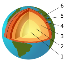
The
Earth's layered structure. (1) inner core; (2) outer core; (3) lower mantle; (4) upper mantle; (5) lithosphere; (6) crust (part of the lithosphere)

Earth layered structure. Typical wave paths from earthquakes like these gave early seismologists insights into the layered structure of the Earth
Advances in
seismology,
computer modeling, and
mineralogy and
crystallography at high temperatures and pressures give insights into the internal composition and structure of the Earth.
Seismologists can use the arrival times of
seismic waves in reverse to image the interior of the Earth. Early advances in this field showed the existence of a liquid
outer core (where
shear waves were not able to propagate) and a dense solid
inner core. These advances led to the development of a layered model of the Earth, with a
crust and
lithosphere on top, the
mantle below (separated within itself by
seismic discontinuities at 410 and 660 kilometers), and the outer core and inner core below that. More recently, seismologists have been able to create detailed images of wave speeds inside the earth in the same way a doctor images a body in a CT scan. These images have led to a much more detailed view of the interior of the Earth, and have replaced the simplified layered model with a much more dynamic model.
Mineralogists have been able to use the pressure and temperature data from the seismic and modelling studies alongside knowledge of the elemental composition of the Earth to reproduce these conditions in experimental settings and measure changes in crystal structure. These studies explain the chemical changes associated with the major seismic discontinuities in the mantle and show the crystallographic structures expected in the inner core of the Earth.
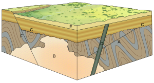
§Geological development of an area
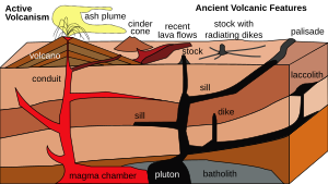
An originally horizontal sequence of sedimentary rocks (in shades of tan) are affected by
igneous activity. Deep below the surface are a
magma chamber and large associated igneous bodies. The magma chamber feeds the
volcano, and sends off shoots of
magma that will later crystallize into dikes and sills. Magma also advances upwards to form
intrusive igneous bodies. The diagram illustrates both a
cinder cone volcano, which releases ash, and a
composite volcano, which releases both lava and ash.

An illustration of the three types of faults. Strike-slip faults occur when rock units slide past one another, normal faults occur when rocks are undergoing horizontal extension, and thrust faults occur when rocks are undergoing horizontal shortening.
The geology of an area changes through time as rock units are deposited and inserted and deformational processes change their shapes and locations.
Rock units are first emplaced either by deposition onto the surface or intrusion into the
overlying rock. Deposition can occur when sediments settle onto the surface of the Earth and later
lithify into sedimentary rock, or when as
volcanic material such as
volcanic ash or
lava flows blanket the surface.
Igneous intrusions such as
batholiths,
laccoliths,
dikes, and
sills, push upwards into the overlying rock, and crystallize as they intrude.
After the initial sequence of rocks has been deposited, the rock units can be
deformed and/or
metamorphosed. Deformation typically occurs as a result of horizontal shortening,
horizontal extension, or side-to-side (
strike-slip) motion. These structural regimes broadly relate to
convergent boundaries,
divergent boundaries, and transform boundaries, respectively, between tectonic plates.
When rock units are placed under horizontal
compression, they shorten and become thicker. Because rock units, other than muds,
do not significantly change in volume, this is accomplished in two primary ways: through
faulting and
folding. In the shallow crust, where
brittle deformation can occur, thrust faults form, which cause deeper rock to move on top of shallower rock. Because deeper rock is often older, as noted by the
principle of superposition, this can result in older rocks moving on top of younger ones. Movement along faults can result in folding, either because the faults are not planar or because rock layers are dragged along, forming drag folds as slip occurs along the fault. Deeper in the Earth, rocks behave plastically, and fold instead of faulting. These folds can either be those where the material in the center of the fold buckles upwards, creating "
antiforms", or where it buckles downwards, creating "
synforms". If the tops of the rock units within the folds remain pointing upwards, they are called
anticlines and
synclines, respectively. If some of the units in the fold are facing downward, the structure is called an overturned anticline or syncline, and if all of the rock units are overturned or the correct up-direction is unknown, they are simply called by the most general terms, antiforms and synforms.
Even higher pressures and temperatures during horizontal shortening can cause both folding and
metamorphism of the rocks. This metamorphism causes changes in the
mineral composition of the rocks; creates a
foliation, or planar surface, that is related to mineral growth under stress. This can remove signs of the original textures of the rocks, such as
bedding in sedimentary rocks, flow features of
lavas, and crystal patterns in
crystalline rocks.
Extension causes the rock units as a whole to become longer and thinner. This is primarily accomplished through
normal faulting and through the ductile stretching and thinning. Normal faults drop rock units that are higher below those that are lower. This typically results in younger units being placed below older units. Stretching of units can result in their thinning; in fact, there is a location within the
Maria Fold and Thrust Belt in which the entire sedimentary sequence of the
Grand Canyon can be seen over a length of less than a meter. Rocks at the depth to be ductilely stretched are often also metamorphosed. These stretched rocks can also pinch into lenses, known as
boudins, after the French word for "sausage", because of their visual similarity.
Where rock units slide past one another,
strike-slip faults develop in shallow regions, and become
shear zones at deeper depths where the rocks deform ductilely.
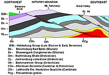
Geologic cross-section of
Kittatinny Mountain. This cross-section shows metamorphic rocks, overlain by younger sediments deposited after the metamorphic event. These rock units were later folded and faulted during the uplift of the mountain.
The addition of new rock units, both depositionally and intrusively, often occurs during deformation. Faulting and other deformational processes result in the creation of topographic gradients, causing material on the rock unit that is increasing in elevation to be eroded by hillslopes and channels. These sediments are deposited on the rock unit that is going down. Continual motion along the fault maintains the topographic gradient in spite of the movement of sediment, and continues to create
accommodation space for the material to deposit. Deformational events are often also associated with volcanism and igneous activity. Volcanic ashes and lavas accumulate on the surface, and igneous intrusions enter from below.
Dikes, long, planar igneous intrusions, enter along cracks, and therefore often form in large numbers in areas that are being actively deformed. This can result in the emplacement of
dike swarms, such as those that are observable across the Canadian shield, or rings of dikes around the
lava tube of a volcano.
All of these processes do not necessarily occur in a single environment, and do not necessarily occur in a single order. The
Hawaiian Islands, for example, consist almost entirely of layered
basaltic lava flows. The sedimentary sequences of the mid-continental United States and the
Grand Canyon in the southwestern United States contain almost-undeformed stacks of sedimentary rocks that have remained in place since
Cambrian time. Other areas are much more geologically complex. In the southwestern United States, sedimentary, volcanic, and intrusive rocks have been metamorphosed, faulted, foliated, and folded. Even older rocks, such as the
Acasta gneiss of the
Slave craton in northwestern
Canada, the
oldest known rock in the world have been metamorphosed to the point where their origin is undiscernable without laboratory analysis. In addition, these processes can occur in stages. In many places, the Grand Canyon in the southwestern United States being a very visible example, the lower rock units were metamorphosed and deformed, and then deformation ended and the upper, undeformed units were deposited. Although any amount of rock emplacement and rock deformation can occur, and they can occur any number of times, these concepts provide a guide to understanding the
geological history of an area.
§Methods of geology
Geologists use a number of field, laboratory, and numerical modeling methods to decipher Earth history and understand the processes that occur on and inside the Earth. In typical geological investigations, geologists use primary information related to
petrology (the study of rocks), stratigraphy (the study of sedimentary layers), and structural geology (the study of positions of rock units and their deformation). In many cases, geologists also study modern soils,
rivers,
landscapes, and
glaciers; investigate past and current life and
biogeochemical pathways, and use
geophysical methods to investigate the subsurface.
§Field methods

A typical
USGS field mapping camp in the 1950s
Geological
field work varies depending on the task at hand. Typical fieldwork could consist of:
§Laboratory methods
§Petrology
In addition to identifying rocks in the field, petrologists identify rock samples in the laboratory. Two of the primary methods for identifying rocks in the laboratory are through
optical microscopy and by using an
electron microprobe. In an
optical mineralogy analysis,
thin sections of rock samples are analyzed through a
petrographic microscope, where the minerals can be identified through their different properties in plane-polarized and cross-polarized light, including their
birefringence,
pleochroism,
twinning, and interference properties with a
conoscopic lens.
[24] In the electron microprobe, individual locations are analyzed for their exact chemical compositions and variation in composition within individual crystals.
[25] Stable[26] and
radioactive isotope[27] studies provide insight into the
geochemical evolution of rock units.
Petrologists can also use
fluid inclusion data
[28] and perform high temperature and pressure physical experiments
[29] to understand the temperatures and pressures at which different mineral phases appear, and how they change through igneous
[30] and metamorphic processes. This research can be extrapolated to the field to understand metamorphic processes and the conditions of crystallization of igneous rocks.
[31] This work can also help to explain processes that occur within the Earth, such as
subduction and
magma chamber evolution.
§Structural geology
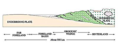
A diagram of an orogenic wedge. The wedge grows through faulting in the interior and along the main basal fault, called the
décollement. It builds its shape into a
critical taper, in which the angles within the wedge remain the same as failures inside the material balance failures along the décollement. It is analogous to a bulldozer pushing a pile of dirt, where the bulldozer is the overriding plate.
Structural geologists use microscopic analysis of oriented thin sections of geologic samples to observe the
fabric within the rocks which gives information about strain within the crystalline structure of the rocks. They also plot and combine measurements of geological structures in order to better understand the orientations of faults and folds in order to reconstruct the history of rock deformation in the area. In addition, they perform analog and numerical experiments of rock deformation in large and small settings.
The analysis of structures is often accomplished by plotting the orientations of various features onto
stereonets. A stereonet is a stereographic projection of a sphere onto a plane, in which planes are projected as lines and lines are projected as points. These can be used to find the locations of fold axes, relationships between faults, and relationships between other geologic structures.
Among the most well-known experiments in structural geology are those involving
orogenic wedges, which are zones in which
mountains are built along
convergent tectonic plate boundaries.
[32] In the analog versions of these experiments, horizontal layers of sand are pulled along a lower surface into a back stop, which results in realistic-looking patterns of faulting and the growth of a
critically tapered (all angles remain the same) orogenic wedge.
[33] Numerical models work in the same way as these analog models, though they are often more sophisticated and can include patterns of erosion and uplift in the mountain belt.
[34] This helps to show the relationship between erosion and the shape of the mountain range. These studies can also give useful information about pathways for metamorphism through pressure, temperature, space, and time.
[35]
§Stratigraphy
In the laboratory, stratigraphers analyze samples of stratigraphic sections that can be returned from the field, such as those from
drill cores.
[36] Stratigraphers also analyze data from geophysical surveys that show the locations of stratigraphic units in the subsurface.
[37] Geophysical data and
well logs can be combined to produce a better view of the subsurface, and stratigraphers often use computer programs to do this in three dimensions.
[38] Stratigraphers can then use these data to reconstruct ancient processes occurring on the surface of the Earth,
[39] interpret past environments, and locate areas for water, coal, and hydrocarbon extraction.
In the laboratory,
biostratigraphers analyze rock samples from outcrop and drill cores for the fossils found in them.
[36] These fossils help scientists to date the core and to understand the
depositional environment in which the rock units formed. Geochronologists precisely date rocks within the stratigraphic section in order to provide better absolute bounds on the timing and rates of deposition.
[40] Magnetic stratigraphers look for signs of magnetic reversals in igneous rock units within the drill cores.
[36] Other scientists perform stable isotope studies on the rocks to gain information about past climate.
[36]
§Planetary geology

Surface of Mars as photographed by the
Viking 2 lander December 9, 1977.
With the advent of
space exploration in the twentieth century, geologists have begun to look at other planetary bodies in the same ways that have been developed to study the
Earth. This new field of study is called
planetary geology (sometimes known as astrogeology) and relies on known geologic principles to study other bodies of the solar system.
Although the Greek-language-origin prefix
geo refers to Earth, "geology" is often used in conjunction with the names of other planetary bodies when describing their composition and internal processes: examples are "the
geology of Mars" and "
Lunar geology". Specialised terms such as
selenology (studies of the Moon),
areology (of Mars), etc., are also in use.
Although planetary geologists are interested in studying all aspects of other planets, a significant focus is to search for evidence of past or present life on other worlds. This has led to many missions whose primary or ancillary purpose is to examine planetary bodies for evidence of life. One of these is the
Phoenix lander, which analyzed
Martian polar soil for water, chemical, and mineralogical constituents related to biological processes.
§Applied geology
§Economic geology
Economic geologists help locate and manage the Earth's
natural resources, such as petroleum and coal, as well as mineral resources, which include metals such as iron, copper, and uranium.
§Mining geology
Mining geology consists of the extractions of mineral resources from the Earth. Some resources of economic interests include
gemstones,
metals, and many minerals such as
asbestos,
perlite,
mica,
phosphates,
zeolites,
clay,
pumice,
quartz, and
silica, as well as elements such as
sulfur,
chlorine, and
helium.
§Petroleum geology
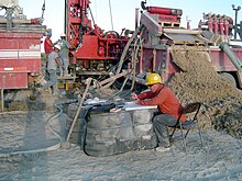
Mud log in process, a common way to study the
lithology when drilling oil wells.
Petroleum geologists study the locations of the subsurface of the Earth which can contain extractable hydrocarbons, especially
petroleum and
natural gas. Because many of these reservoirs are found in
sedimentary basins,
[41] they study the formation of these basins, as well as their sedimentary and tectonic evolution and the present-day positions of the rock units.
§Engineering geology
Engineering geology is the application of the geologic principles to engineering practice for the purpose of assuring that the geologic factors affecting the location, design, construction, operation, and maintenance of engineering works are properly addressed.
In the field of
civil engineering, geological principles and analyses are used in order to ascertain the mechanical principles of the material on which structures are built. This allows tunnels to be built without collapsing, bridges and skyscrapers to be built with sturdy foundations, and buildings to be built that will not settle in clay and mud.
[42]
§Hydrology and environmental issues
Geology and geologic principles can be applied to various environmental problems such as
stream restoration, the restoration of
brownfields, and the understanding of the interaction between
natural habitat and the geologic environment. Groundwater hydrology, or
hydrogeology, is used to locate groundwater,
[43] which can often provide a ready supply of uncontaminated water and is especially important in arid regions,
[44] and to monitor the spread of contaminants in groundwater wells.
[43][45]
Geologists also obtain data through stratigraphy,
boreholes,
core samples, and
ice cores. Ice cores
[46] and sediment cores
[47] are used to for paleoclimate reconstructions, which tell geologists about past and present temperature, precipitation, and
sea level across the globe. These datasets are our primary source of information on
global climate change outside of instrumental data.
[48]
§Natural hazards
Geologists and geophysicists study natural hazards in order to enact safe
building codes and warning systems that are used to prevent loss of property and life.
[49] Examples of important natural hazards that are pertinent to geology (as opposed those that are mainly or only pertinent to meteorology) are:
Rockfall in the Grand Canyon
§History of geology
The study of the physical material of the Earth dates back at least to
ancient Greece when
Theophrastus (372–287 BCE) wrote the work
Peri Lithon (
On Stones). During the
Roman period,
Pliny the Elder wrote in detail of the many minerals and metals then in practical use – even correctly noting the origin of
amber.
Some modern scholars, such as
Fielding H. Garrison, are of the opinion that modern geology began in the
medieval Islamic world.
[51] Abu al-Rayhan al-Biruni (973–1048 CE) was one of the earliest
Muslim geologists, whose works included the earliest writings on the
geology of India, hypothesizing that the
Indian subcontinent was once a sea.
[52] Islamic Scholar
Ibn Sina (Avicenna, 981–1037) proposed detailed explanations for the formation of mountains, the origin of earthquakes, and other topics central to modern geology, which provided an essential foundation for the later development of the science.
[53][54] In China, the
polymath Shen Kuo (1031–1095) formulated a hypothesis for the process of land formation: based on his observation of fossil animal shells in a geological
stratum in a mountain hundreds of miles from the ocean, he inferred that the land was formed by erosion of the mountains and by
deposition of
silt.
[55]
Nicolas Steno (1638–1686) is credited with the
law of superposition, the
principle of original horizontality, and the
principle of lateral continuity: three defining principles of
stratigraphy.
The word
geology was first used by
Ulisse Aldrovandi in 1603,
[56] then by
Jean-André Deluc in 1778 and introduced as a fixed term by
Horace-Bénédict de Saussure in 1779. The word is derived from the
Greek γῆ,
gê, meaning "earth" and λόγος,
logos, meaning "speech".
[57] But according to another source, the word "geology" comes from a Norwegian, Mikkel Pedersøn Escholt (1600–1699), who was a priest and scholar. Escholt first used the definition in his book titled,
Geologica Norvegica (1657).
[58]
William Smith (1769–1839) drew some of the first geological maps and began the process of ordering
rock strata (layers) by examining the fossils contained in them.
[50]
James Hutton is often viewed as the first modern
geologist.
[59] In 1785 he presented a paper entitled
Theory of the Earth to the
Royal Society of Edinburgh. In his paper, he explained his theory that the Earth must be much older than had previously been supposed in order to allow enough time for mountains to be eroded and for
sediments to form new rocks at the bottom of the sea, which in turn were raised up to become dry land. Hutton published a two-volume version of his ideas in 1795 (
Vol. 1,
Vol. 2).

Scotsman James Hutton, father of modern geology
Followers of Hutton were known as
Plutonists because they believed that some rocks were formed by
vulcanism, which is the deposition of lava from volcanoes, as opposed to the
Neptunists, led by
Abraham Werner, who believed that all rocks had settled out of a large ocean whose level gradually dropped over time.
The first
geological map of the U.S. was produced in 1809 by
William Maclure.
[60][61] In 1807, Maclure commenced the self-imposed task of making a geological survey of the United States. Almost every state in the Union was traversed and mapped by him, the
Allegheny Mountains being crossed and recrossed some 50 times.
[62] The results of his unaided labours were submitted to the
American Philosophical Society in a memoir entitled
Observations on the Geology of the United States explanatory of a Geological Map, and published in the
Society's Transactions, together with the nation's first geological map.
[63] This antedates
William Smith's geological map of England by six years, although it was constructed using a different classification of rocks.
Sir Charles Lyell first published his famous book,
Principles of Geology,
[64] in 1830. This book, which influenced the thought of
Charles Darwin, successfully promoted the doctrine of
uniformitarianism. This theory states that slow geological processes have occurred throughout the
Earth's history and are still occurring today. In contrast,
catastrophism is the theory that Earth's features formed in single, catastrophic events and remained unchanged thereafter. Though Hutton believed in uniformitarianism, the idea was not widely accepted at the time.
Much of 19th-century geology revolved around the question of the
Earth's exact age. Estimates varied from a few hundred thousand to billions of years.
[65] By the early 20th century,
radiometric dating allowed the Earth's age to be estimated at two billion years. The awareness of this vast amount of time opened the door to new theories about the processes that shaped the planet.
Some of the most significant advances in 20th-century geology have been the development of the theory of
plate tectonics in the 1960s and the refinement of estimates of the planet's age. Plate tectonics theory arose from two separate geological observations:
seafloor spreading and
continental drift. The theory revolutionized the
Earth sciences. Today the Earth is known to be approximately 4.5 billion years old.
[66]
§Fields or related disciplines


.png)


