Graham's number is an enormous number that arises as an upper bound on the answer of a problem in the mathematical field of Ramsey theory. It is named after mathematician Ronald Graham, who used the number as a simplified explanation of the upper bounds of the problem he was working on in conversations with popular science writer Martin Gardner. Gardner later described the number in Scientific American
in 1977, introducing it to the general public. At the time of its
introduction, it was the largest specific positive integer ever to have
been used in a published mathematical proof. The number was published
in the 1980 Guinness Book of World Records, adding to its popular interest. Other specific integers (such as TREE(3))
known to be far larger than Graham's number have since appeared in many
serious mathematical proofs, for example in connection with Harvey Friedman's various finite forms of Kruskal's theorem.
Additionally, smaller upper bounds on the Ramsey theory problem from
which Graham's number derived have since been proven to be valid.
Graham's number is much larger than many other large numbers such as Skewes' number and Moser's number, both of which are in turn much larger than a googolplex. As with these, it is so large that the observable universe is far too small to contain an ordinary digital representation of Graham's number, assuming that each digit occupies one Planck volume,
possibly the smallest measurable space. But even the number of digits
in this digital representation of Graham's number would itself be a
number so large that its digital representation cannot be represented in
the observable universe. Nor even can the number of digits of that
number—and so forth, for a number of times far exceeding the total
number of Planck volumes in the observable universe. Thus Graham's
number cannot even be expressed in this way by power towers of the form .
However, Graham's number can be explicitly given by computable recursive formulas using Knuth's up-arrow notation or equivalent, as was done by Graham. As there is a recursive formula to define it, it is much smaller than typical busy beaver
numbers. Though too large to be computed in full, the sequence of
digits of Graham's number can be computed explicitly through simple
algorithms. The last 12 digits are 262464195387. With Knuth's up-arrow
notation, Graham's number is , where
Context
Example
of a 2-colored 3-dimensional cube containing one single-coloured
4-vertex coplanar complete subgraph. The subgraph is shown below the
cube. Note that this cube would contain no such subgraph if, for
example, the bottom edge in the present subgraph were replaced by a blue
edge – thus proving by counterexample that N* > 3.
Graham's number is connected to the following problem in Ramsey theory:
Connect each pair of geometric vertices of an n-dimensional hypercube to obtain a complete graph on 2nvertices. Colour each of the edges of this graph either red or blue. What is the smallest value of n for which every such colouring contains at least one single-coloured complete subgraph on four coplanar vertices?
In 1971, Graham and Rothschild proved that this problem has a solution N*, giving as a bound 6 ≤ N* ≤ N, with N being a large but explicitly defined number , where in Knuth's up-arrow notation; the number is between 4 → 2 → 8 → 2 and 2 → 3 → 9 → 2 in Conway chained arrow notation. This was reduced in 2014 via upper bounds on the Hales–Jewett number to . The lower bound of 6 was later improved to 11 by Geoffrey Exoo in 2003, and to 13 by Jerome Barkley in 2008. Thus, the best known bounds for N* are 13 ≤ N* ≤ N'.
Graham's number, G, is much larger than N: , where .
This weaker upper bound for the problem, attributed to an unpublished
work of Graham, was eventually published and named by Martin Gardner in Scientific American in November 1977.
Publication
The number gained a degree of popular attention when Martin Gardner described it in the "Mathematical Games" section of Scientific American
in November 1977, writing that Graham had recently established, in an
unpublished proof, "a bound so vast that it holds the record for the
largest number ever used in a serious mathematical proof." The 1980 Guinness Book of World Records repeated Gardner's claim, adding to the popular interest in this number. According to physicist John Baez,
Graham invented the quantity now known as Graham's number in
conversation with Gardner. While Graham was trying to explain a result
in Ramsey theory which he had derived with his collaborator Bruce Lee Rothschild,
Graham found that the quantity now known as Graham's number was easier
to explain than the actual number appearing in the proof. Because the
number which Graham described to Gardner is larger than the number in
the paper itself, both are valid upper bounds for the solution to the
problem studied by Graham and Rothschild.
Definition
Using Knuth's up-arrow notation, Graham's number G (as defined in Gardner's Scientific American article) is
where the number of arrows in each subsequent layer is specified by the value of the next layer below it; that is,
where
and where a superscript on an up-arrow indicates how many arrows there are. In other words, G is calculated in 64 steps: the first step is to calculate g1 with four up-arrows between 3s; the second step is to calculate g2 with g1 up-arrows between 3s; the third step is to calculate g3 with g2 up-arrows between 3s; and so on, until finally calculating G = g64 with g63 up-arrows between 3s.
Equivalently,
and the superscript on f indicates an iteration of the function, e.g., . Expressed in terms of the family of hyperoperations, the function f is the particular sequence , which is a version of the rapidly growing Ackermann functionA(n, n). (In fact, for all n.) The function f can also be expressed in Conway chained arrow notation as , and this notation also provides the following bounds on G:
Magnitude
To
convey the difficulty of appreciating the enormous size of Graham's
number, it may be helpful to express—in terms of exponentiation
alone—just the first term (g1) of the rapidly growing 64-term sequence. First, in terms of tetration () alone:
where the number of 3s in the expression on the right is
Now each tetration () operation reduces to a power tower () according to the definition
where there are X 3s.
Thus,
becomes, solely in terms of repeated "exponentiation towers",
and where the number of 3s in each tower, starting from the
leftmost tower, is specified by the value of the next tower to the
right.
In other words, g1 is computed by first calculating the number of towers, (where the number of 3s is ), and then computing the nth tower in the following sequence:
1st tower: 3
2nd tower: 3↑3↑3 (number of 3s is 3) = 7625597484987
3rd tower: 3↑3↑3↑3↑...↑3 (number of 3s is 7625597484987) = …
⋮
g1 = nth tower: 3↑3↑3↑3↑3↑3↑3↑...↑3 (number of 3s is given by the n-1th tower)
where the number of 3s in each successive tower is given by the tower
just before it. Note that the result of calculating the third tower is
the value of n, the number of towers for g1.
The magnitude of this first term, g1, is so large that it is practically incomprehensible, even though the above display is relatively easy to comprehend. Even n, the mere number of towers in this formula for g1, is far greater than the number of Planck volumes (roughly 10185 of them) into which one can imagine subdividing the observable universe. And after this first term, still another 63 terms remain in the rapidly growing g sequence before Graham's number G = g64 is reached. To illustrate just how fast this sequence grows, while g1 is equal to with only four up arrows, the number of up arrows in g2 is this incomprehensibly large number g1.
Rightmost decimal digits
Graham's number is a "power tower" of the form 3↑↑n (with a very large value of n), so its rightmost decimal digits must satisfy certain properties common to all such towers. One of these properties is that all such towers of height greater than d (say), have the same sequence of d rightmost decimal digits. This is a special case of a more general property: The d rightmost decimal digits of all such towers of height greater than d+2, are independent of the topmost "3" in the tower; i.e., the topmost "3" can be changed to any other non-negative integer without affecting the d rightmost digits.
Number of different possible values of 3↑3↑…3↑x when all but the rightmost d decimal digits are ignored
Number of digits (d)
3↑x
3↑3↑x
3↑3↑3↑x
3↑3↑3↑3↑x
3↑3↑3↑3↑3↑x
1
4
(1,3,9,7)
2
(3,7)
1
(7)
1
(7)
1
(7)
2
20
(01,03,…,87,…,67)
4
(03,27,83,87)
2
(27,87)
1
(87)
1
(87)
3
100
(001,003,…,387,…,667)
20
(003,027,…387,…,587)
4
(027,987,227,387)
2
(987,387)
1
(387)
The particular rightmost d digits that are ultimately shared
by all sufficiently tall towers of 3s are in bold text, and can be seen
developing as the tower height increases. For any fixed number of
digits d (row in the table), the number of values possible for 33↑…3↑x mod 10d, as x
ranges over all nonnegative integers, is seen to decrease steadily as
the height increases, until eventually reducing the "possibility set" to
a single number (colored cells) when the height exceeds d+2.
A simple algorithm for computing these digits may be described as follows: let x = 3, then iterate, d times, the assignmentx = 3x mod 10d. Except for omitting any leading 0s, the final value assigned to x (as a base-ten numeral) is then composed of the d rightmost decimal digits of 3↑↑n, for all n > d. (If the final value of x has fewer than d digits, then the required number of leading 0s must be added.)
Let k be the numerousness of these stable digits, which satisfy the congruence relation G(mod 10k)≡[GG](mod 10k).
k=t-1, where G(t):=3↑↑t. It follows that, g63 ≪ k ≪ g64.
The algorithm above produces the following 500 rightmost decimal
digits of Graham's number (or of any tower of more than 500 3s):
Nuclear scientists at the U.S. Department of Energy’s (DOE)
Argonne National Laboratory have developed an algorithm for estimating
the capital cost of building advanced nuclear reactor designs.
Argonne scientists have developed a new algorithm for
estimating the capital cost of building advanced nuclear reactor
designs. (Image by Shutterstock / Denis Bychkov.)
How can you accurately
predict how much it will cost to build a new nuclear power plant?
Nuclear scientists at the U.S. Department of Energy’s (DOE)
Argonne National Laboratory are working to provide answers to this
question. They have developed a new algorithm for estimating the capital
cost of building advanced nuclear reactor designs.
About 449 nuclear reactors currently operate worldwide, serving a portion of the world’s energy needs. However, more than 1.6
billion people across the globe still lack access to electricity and,
according to the World Nuclear Association, global demand for energy is
projected to rise by 50 percent by 2040.
Nuclear power plants currently generate an estimated 20 percent of our nation’s electricity; with nearly 100 reactors, the United States leads other nations in the number of reactors in operation.
According to experts, nuclear energy is the only carbon-free power in
existence that can satisfy demand at the scale required by cities and
factories. However, the broad array of available energy sources — fossil
fuels, solar, hydropower and wind, to name a few — creates stiff
competition in the marketplace. Opponents of nuclear energy often cite
high construction costs and cost overruns as reasons to discourage the
construction of additional nuclear power plants.
The new tool allows researchers to “focus on specific components of the cost drivers and ask, ‘How
can I reduce that cost?’ The ability to do that will help create a
reasonable and appropriate cost estimate and maximize the effect of
research dollars dedicated to reducing overall costs.” — Temi Taiwo,
program manager in Argonne’s Nuclear Science and Engineering division
To understand better the cost of nuclear systems and what drives
those costs, Argonne scientist Francesco Ganda has created a method for
estimating the cost of building nuclear energy systems, including
nuclear reactors. A report coauthored with T.K. Kim and Temi Taiwo, two
colleagues in the laboratory’s Nuclear Science and Engineering division,
outlines the details of the approach.
During the “golden era” of nuclear reactor innovation in the United States (the 1950s and 1960s), the federal government heavily funded R&D
to enable the country to compete with the then-USSR in scientific
discovery. This effort enabled the accumulation of knowledge that formed
the technological foundation for building the current operating fleet
between the late 1960s and the mid-1990s.
However, because reactor design has seen significant advances since the
end of that era, accurately projecting building costs today is
difficult.
As Kim observed, “We have had more than a 20-year gap in building nuclear power plants in the United States.”
Because of this hiatus, the costs associated with building a plant today aren’t readily or easily discernible, Kim said. “That’s
a big issue and a big problem, because an accurate cost estimation is
an important factor in planning a multi-billion-dollar, multi-year
project like a nuclear plant.”
The algorithm developed by Ganda and his colleagues provides a valuable tool, said Taiwo, that allows users to “focus on specific components of the cost drivers and ask, ‘How
can I reduce that cost?’ The ability to do that will help create a
reasonable and appropriate cost estimate and maximize the effect of
research dollars dedicated to reducing overall costs.”
Formulating the algorithm required a thorough examination of many
facets of the nuclear industry, including understanding the reasons for
the cost overruns observed historically for several of the U.S. nuclear
power plants, said Ganda. “For this work, we studied the main drivers of cost, focusing on the most expensive. At this point, the algorithm considers the 30 most expensive components of the capital cost, which contribute more than 80
percent of the direct costs of building a pressurized water reactor.
However, we have plans to expand the set of components beyond that, in
order to increase the algorithm’s fidelity.”
“By having a tool like this algorithm, we
are able to identify which cost components are more (or less) expensive,
and by how much. This potentially provides insight into the cost
drivers of this advanced technology.”
Although Ganda cautions that more work remains to be done on the algorithm, a comprehensive report is now available in the public domain. Ganda also will present a paper announcing the algorithm in September at the 2018
Pacific Basin Nuclear Conference in San Francisco. Organized by the
American Nuclear Society, this event brings together nuclear scientists
and government officials from around the globe, particularly those from
Pacific Basin nations.
Funding for this project comes from the DOE Office of Nuclear Energy’s (NE) Nuclear Technology Research and Development (NTRD) office.
The mission of DOENE
is to advance nuclear power to meet the nation’s energy, environmental,
and national security needs. Under the guidance of three research
objectives, NE resolves barriers to technical,
cost, safety, security, and proliferation resistance through
early-stage research, development, and demonstration to:
Enhance the long-term viability and competitiveness of the existing U.S. reactor fleet.
Develop an advanced reactor pipeline.
Implement and maintain national strategic fuel cycle and supply chain infrastructure.
Argonne National Laboratory
seeks solutions to pressing national problems in science and
technology. The nation’s first national laboratory, Argonne conducts
leading-edge basic and applied scientific research in virtually every
scientific discipline. Argonne researchers work closely with researchers
from hundreds of companies, universities, and federal, state and
municipal agencies to help them solve their specific problems, advance
America’s scientific leadership and prepare the nation for a better
future. With employees from more than 60 nations, Argonne is managed by UChicago Argonne, LLC for the U.S. Department of Energy’s Office of Science. The U.S. Department of Energy’s Office of Science is
the single largest supporter of basic research in the physical sciences
in the United States and is working to address some of the most
pressing challenges of our time. For more information, visit the Office of Science website.
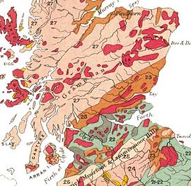
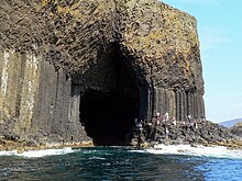
The Highlands and Islands lie to the north and west of the Highland Boundary Fault, which runs from Arran to Stonehaven. This part of Scotland largely comprises ancient rocks, from Cambrian and Precambrian times, that were uplifted to form a mountain chain during the later Caledonian orogeny. These foundations are interspersed with many igneous intrusions of more recent age, the remnants of which have formed mountain massifs such as the Cairngorms and SkyeCuillins. A significant exception to the above are the fossil-bearing beds of the Old Red Sandstone found principally along the Moray Firth coast and in the Orkney islands. These rocks are around 400 million years old, and were laid down in the Devonianperiod. The Highlands are generally mountainous and are bisected by the Great Glen Fault. The highest elevations in the British Isles are found here, including Ben Nevis, the highest peak at 1,344 metres (4,409 ft). Scotland has over 790 islands, divided into four main groups: Shetland, Orkney, and the Hebrides, further sub-divided into the Inner Hebrides and Outer Hebrides.
The Hebridean archipelago outlier of St Kilda is composed of Paleogeneigneous formations of granites and gabbro,
heavily weathered by the elements. These islands represent the remnants
of a long extinct ring volcano rising from a seabed plateau
approximately 40 m (130 ft) below sea level.
The geology of Shetland is complex with numerous faults and folds. These islands are Scotland's most northerly area of Caledonian orogenic rocks and there are outcrops
of Lewisian, Dalradian and Moine metamorphic rocks with similar
histories to their equivalents on the Scottish mainland. Similarly,
there are also Old Red Sandstone deposits and granite intrusions. The most distinctive feature is the ultrabasicophioliteperidotite and gabbro on Unst and Fetlar, which are remnants of the Iapetus Ocean floor. Much of Shetland's economy depends on the oil-bearing sediments in the surrounding seas.
Midland Valley
Often referred to as the Central Lowlands, this is a rift valley mainly comprising Paleozoic
formations. Many of these sediments have economic significance for it
is here that the coal and iron bearing rocks that fuelled Scotland's industrial revolution are to be found. Although relatively low-lying, hills such as the Pentland Hills, Ochils and Campsie Fells are rarely far from view. This area has also experienced intense volcanism, Arthur's Seat in Edinburgh being the remnant of a once much larger volcano active in the Carboniferous period about 340 million years ago.
Southern Uplands
The Southern Uplands
The Southern Uplands
are a range of hills almost 200 km (120 mi) long, interspersed with
broad valleys. They lie south of a second fault line running from Ballantrae towards Dunbar. The geological foundations largely comprise Silurian deposits laid down some 4-500 million years ago.
Post-glacial events
The whole of Scotland was covered by ice sheets during the Pleistoceneice ages and the landscape is much affected by glaciation, and to a lesser extent by subsequent sea level changes. In the post-glacial epoch, circa 6100 BC, Scotland and the Faroe Islands experienced a tsunami up to 20 metres high caused by the Storegga Slides, an immense underwater landslip off the coast of Norway.
Earth tremors are infrequent and usually slight. The Great Glen is the
most seismically active area of Britain, but the last event of any size
was in 1901.
Chronology
Archean and Proterozoic eons
The oldest rocks of Scotland are the Lewisian gneisses, which were formed in the Precambrian period, up to 3,000 Ma (million years ago). They are among the oldest rocks in both Europe and the World. They form the basement to the west of the Moine Thrust on the mainland, in the Outer Hebrides and on the islands of Coll and Tiree. These rocks are largely igneous in origin, mixed with metamorphosed marble, quartzite and mica schist and intruded by later basaltic dykes and granite magma. One of these intrusions forms the summit plateau of the mountain Roineabhal in Harris. The granite here is anorthosite, and is similar in composition to rocks found in the mountains of the Moon.
Suilven is formed of Torridoniansandstone, sitting on a landscape of Lewisian gneiss.
Torridonian sandstones were also laid down in this period over the
gneisses, and these contain the oldest signs of life in Scotland. In
later Precambrian times, thick sediments of sandstones, limestones muds and lavas were deposited in what is now the Highlands of Scotland.
Paleozoic era
Cambrian period
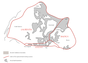
Further sedimentary deposits were formed through the Cambrian period (541–485 Ma), some of which, along with the earlier Precambrian sediments, metamorphosed into the Dalradian series. This is composed of a wide variety of materials, including mica schist, biotite gneiss schist, schistose grit, greywacke and quartzite. The area that would become Scotland was at this time close to the south pole and part of Laurentia. Fossils from the north-west Highlands indicate the presence of trilobites and other primitive forms of life.
Ordovician period
The proto-Scotland landmass moved northwards, and from 460–430 Ma, sandstone, mudstone and limestone were deposited in the area that is now the Midland Valley. This occurred in shallow tropical seas at the margins of the Iapetus Ocean. The Ballantrae Complex near Girvan was formed from this ocean floor and is similar in composition to rocks found at The Lizard in Cornwall.
Nonetheless, northern and southern Britain were far apart at the
beginning of this period, although the gap began to close as the
continent of Avalonia broke away from Gondwana, collided with Baltica and drifted towards Laurentia. The Caledonian orogeny began forming a mountain chain from Norway to the Appalachians.
There was an ice age in the southern hemisphere, and the first mass
extinction of life on Earth took place at the end of this period.
Silurian period
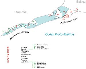
The collision of Avalonia, Baltica and Laurentia (The names are in French.)
During the Silurian period (444–419 Ma) the continent of Laurentia gradually collided with Baltica, joining Scotland to the area that would become England and Europe. Sea levels rose as the Ordovician
ice sheets melted, and tectonic movements created major faults which
assembled the outline of Scotland from previously scattered fragments.
These faults are the Highland Boundary Fault, separating the Lowlands from the Highlands, the Great Glen Fault that divides the North-west Highlands from the Grampians, the Southern Uplands Fault and the Iapetus Suture, which runs from the Solway Firth to Lindisfarne and which marks the close of the Iapetus Ocean and the joining of northern and southern Britain.
Silurian rocks form the Southern Uplands
of Scotland, which were pushed up from the sea bed during the collision
with Baltica/Avalonia. The majority of the rocks are weakly
metamorphosed coarse greywacke. The Highlands were also affected by these collisions, creating a series of thrust faults in the northwest Highlands including the Moine Thrust, the understanding of which played an important role in 19th century geological thinking. Volcanic activity occurred across Scotland as a result of the collision of the tectonic plates, with volcanoes in southern Scotland, and magma chambers in the north, which today form the granite mountains such as the Cairngorms.
Devonian period
The Old Red Sandstone Continent in the Devonian
The Scottish landmass now formed part of the Old Red Sandstone Continent and lay some 25 degrees south of the equator, moving slowly north during this period to 10 degrees south. The accumulations of Old Red Sandstone laid down from 408 to 370 million years ago were created as earlier Silurian rocks, uplifted by the formation of Pangaea, eroded and were deposited into a body of fresh water (probably a series of large river deltas). A huge freshwater lake - Lake Orcadie
- existed on the edges of the eroding mountains stretching from
Shetland to the southern Moray Firth. The formations are extremely
thick, up to 11,000 metres in places, and can be subdivided into three
categories "Lower", "Middle", and "Upper" from oldest to youngest. As a
result, the Old Red Sandstone is an important source of fish fossils
and it was the object of intense geological studies in the 19th
century. In Scotland these rocks are found predominantly in the Moray
Firth basin and Orkney Archipelago, and along the southern margins of
the Highland Boundary Fault.
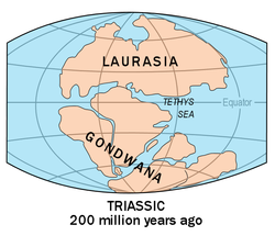
Map of Pangaea, during the Triassic period, 249 million years ago
The Old Red Sandstone Continent became a part of the supercontinent Pangaea in the Permian
(299–252 Ma), during which proto-Britain continued to drift northwards.
Scotland's climate was arid at this time and some fossils of reptiles
have been recovered. However, Permian sandstones are found in only a few
places - principally in the south west, on the island of Arran, and on
the Moray coast. Stone quarried from Hopeman in Moray has been used in the National Museum and Scottish Parliament buildings in Edinburgh.
During the Triassic
(252–201 Ma), much of Scotland remained in desert conditions, with
higher ground in the Highlands and Southern Uplands providing sediment
to the surrounding basins via flash floods. This is the origin of
sandstone outcrops near Dumfries, Elgin and the Isle of Arran. Towards the close of this period sea levels began to rise and climatic conditions became less arid.
Jurassic period
Pangaea was formed by the convergence of multiple continental masses and later broke apart to form two primary continents, Laurasia and Gondwana
As the Jurassic (201–145 Ma) started, Pangaea began to break up into two continents, Gondwana and Laurasia, marking the beginning of the separation of Scotland and North America. Sea levels rose, as Britain and Ireland drifted on the Eurasian Plate
to between 30° and 40° north. Most of northern and eastern Scotland
including Orkney, Shetland and the Outer Hebrides remained above the
advancing seas, but the south and south-west were inundated. There are
only isolated sedimentary rocks remaining on land from this period, on the Sutherland coast near Golspie and, forming the Great Estuarine Group, on Skye, Mull, Raasay and Eigg. This period does however have considerable significance.
The burial of algae and bacteria below the mud of the sea floor during this time resulted in the formation of North Sea oil and natural gas,
much of it trapped in overlying sandstone by deposits formed as the
seas fell to form the swamps and salty lakes and lagoons that were home
to dinosaurs.
Cretaceous period
In the Cretaceous (145–66 Ma), Laurasia split into the continents of North America and Eurasia. Sea levels rose globally during this period and much of low-lying Scotland was covered in a layer of chalk. Although large deposits of Cretaceous rocks were laid down over Scotland, these have not survived erosion except in a few places on the west coast such as Loch Aline in Morvern where they form a part of the Inner Hebrides Group. At the end of this period the Cretaceous–Paleogene extinction event brought the age of dinosaurs to a close.
Cenozoic era
Paleogene period
In the early Paleogene period between 63 and 52 Ma, the last volcanic rocks in the British Isles were formed. As North America and Greenland
separated from Europe, the Atlantic Ocean slowly formed. This led to a
chain of volcanic sites west of mainland Scotland including on Skye, the Small Isles and St. Kilda, in the Firth of Clyde on Arran and Ailsa Craig and at Ardnamurchan. Sea levels began to fall, and for the first time the general outline of the modern British Isles was revealed. At the beginning of this period the climate was sub-tropical and
erosion was caused by chemical weathering, creating characteristic
features of the Scottish landscape such as the topographical basin of
the Howe of Alford near Aberdeen. The vegetation of the period is known from Paleocene sedimentary deposits on Isle of Mull. The rich flora here included temperate-climate tree species such as plane, hazel, oak, Cercidiphyllum, Metasequoia and ginkgo.
Neogene period
Miocene and Pliocene epochs
In the Miocene and Pliocene
epochs further uplift and erosion occurred in the Highlands. Plant and
animal types developed into their modern forms. Scotland lay in its
present position on the globe. As the Miocene progressed, temperatures
dropped and remained similar to today's.
Several ice ages shaped the land through glacial erosion, creating u-shaped valleys and depositing boulder clays,
especially on the western seaboard. The last major incursion of ice
peaked about 18,000 years ago, leaving other remnant features such at
the granite tors on the Cairngorm mountain plateaux.
Holocene epoch
Over the last twelve thousand years the most significant new geological features have been the deposits of peat and the development of coastal alluvium. Post-glacial rises in sea level have been combined with isostatic rises of the land resulting in a relative fall in sea level in most areas. In some places, such as Culbin in Moray, these changes in relative sea level have created a complex series of shorelines. A rare type of Scottish coastline found largely in the Hebrides consists of machairhabitat,
a low lying dune pasture land formed as the sea level dropped leaving a
raised beach. In the present day, Scotland continues to move slowly
north.
Geologists in Scotland
James Hutton, painted by Abner Lowe
Scottish geologists and non-Scots working in Scotland have played an
important part in the development of the science, especially during its
pioneering period in the late 18th century and 19th century.
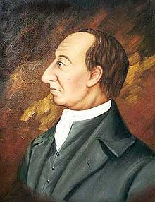
James Hutton (1726–1797), the "father of modern geology", was born in Edinburgh. His Theory of the Earth,
published in 1788, proposed the idea of a rock cycle in which weathered
rocks form new sediments and that granites were of volcanic origin. At Glen Tilt in the Cairngorm mountains he found granite penetrating metamorphicschists. This showed to him that granite formed from the cooling of molten rock, not precipitation out of water as the Neptunists of the time believed. This sight is said to have "filled him with delight". Regarding geological time scales he famously remarked "that we find no vestige of a beginning, no prospect of an end".
John Playfair (1748–1819) from Angus was a mathematician who developed an interest in geology through his friendship with Hutton. His 1802 Illustrations of the Huttonian Theory of the Earth were influential in the latter's success.
John MacCulloch (1773–1835) was born in Guernsey and like Hutton before him, studied medicine at Edinburgh University.
A president of the Geological Society from 1815–17, he is best
remembered for producing the first geological map of Scotland, published
in 1836. 'MacCulloch's Tree', a 40-foot (12 m) high fossil conifer in the Mull lava flows, is named after him.
Charles Lyell
Sir Charles Lyell (1797–1875) was also from Angus and his Principles of Geology built on Hutton's ideas. Lyell's theory of uniformitarianism
and his interpretation of geologic change as the steady accumulation of
minute changes over enormously long spans of time was a central theme
in the Principles, and a powerful influence on the young Charles Darwin. (Robert FitzRoy, captain of HMS Beagle, loaned Darwin a copy of Volume 1 of the first edition just before they set out on the 'Voyage of the Beagle'.) Lyell is buried in Westminster Abbey.
Murchison's memorial tablet in Perm.
"To Roderick Impey Murchison, Scottish geologist, explorer of Perm
Krai, who gives to the last period of the Palaeozoic era the name of
Permian."
Sir Roderick Murchison (1792–1871) was born in Ross and Cromarty and served under Wellesley in the Peninsular War. Knighted in 1846, his main achievements were the investigation of Silurian rocks published as The Silurian System in 1839 and of Permian deposits in Russia. The Murchison crater on the Moon and at least fifteen geographical locations on Earth are named after him.
Hugh Miller (1802–56) from Cromarty was a stonemason and self-taught geologist. His 1841 publication The Old Red Sandstone
became a bestseller. The fossils founds in these rocks were one of his
fascinations, although his deep religious convictions led him to oppose
the idea of biological evolution.
James Croll (1821–90) developed a theory of climate change based on changes in the Earth's orbit. Born near Perth, he was self-educated and his interest in science led to his becoming appointed as a janitor in the museum at the Andersonian College and Museum, Glasgow in 1859. His 1864 paper On the Physical Cause of the Changes of Climate during Glacial Epochs led to a position in the Edinburgh office of the Geological Survey of Scotland, as keeper of maps and correspondence, where Sir Archibald Geikie, encouraged his research. He was eventually to become a Fellow of the Royal Society.
Sir Archibald Geikie (1835–1924) was the first to recognise that there had been multiple glaciations, and his 1863 paper On the glacial drift of Scotland was a landmark in the emergent theories of glaciation. He became Director-General of the Geological Survey of the United Kingdom in 1888 and was also well known for his work on volcanism.
Arthur Holmes (1890–1965) was born in England and became Regius Professor of Geology at the University of Edinburgh in 1943. His magnum opus was Principles of Physical Geology,
first published in 1944, in which he proposed the idea that slow moving
convection currents in the Earth's mantle created 'continental drift'
as it was then called. He also pioneered the discipline of geochronology. He lived long enough to see the theory of plate tectonics become widely accepted, and he is regarded as one of the most influential geologists of the 20th century.
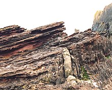
Siccar Point, Berwickshire
is world-famous as one of the sites that proved Hutton's views about
the immense age of the Earth. Here Silurian rocks have been tilted
almost to the vertical. Younger Carboniferous rocks lie unconformably
over the top of them, dipping gently, indicating that an enormous span
of time must have passed between the creation of the two beds. When
Hutton and James Hall visited the site in 1788 their companion Playfair wrote:
"On us who saw these phenomenon for the first time the
impression will not easily be forgotten...We felt necessarily carried
back to a time when the schistus on which we stood was yet at the bottom
of the sea, and when the sandstone before us was only beginning to be
deposited, in the shape of sand or mud, from the waters of the
supercontinent ocean... The mind seemed to grow giddy by looking so far
back into the abyss of time; and whilst we listened with earnestness and
admiration to the philosopher who was now unfolding to us the order and
series of these wonderful events, we became sensible how much further
reason may sometimes go than imagination may venture to follow." John Playfair (1805) Transactions of the Royal Society of Edinburgh, vol. V, pt. III.
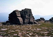
Knockan Crag
The Moine Thrust in Assynt
is one of the most studied geological features in the world. Its
discovery in the 1880s was a milestone in the history of geology as it
was one of the first thrust belts in the world to be identified. Investigations by John Horne and Benjamin Peach resolved a dispute between Murchison and Geikie on the one hand and James Nicol and Charles Lapworth on the other. The latter believed that older Moine rocks lay on top of younger Cambrian rocks at Knockan Crag, and Horne and Peach's work confirmed this in their classic paper The Geological Structure of the Northwest Highlands of Scotland, which was published in 1907. A statue to these two pioneers of fieldwork was erected at Inchnadamph near the hotel there which played a prominent part in the annals of early geology.[70] This area is at the heart of the 'North West Highlands Geopark'.
Dob's Linn
Lapworth also had a prominent role to play in the fame of Dob's Linn, a small gorge in the Scottish Borders,
which contains the 'golden spike' (i.e. the official international
boundary or stratotype) between the Ordovician and Silurian periods.
Lapworth's work in this area, especially his examination of the complex stratigraphy of the Silurian rocks by comparing fossil graptolites, was crucial in to the early understanding of these epochs.
Skye Cuillin
Sgurr nan Gillean and the Pinnacle Ridge from Basteir gorge, Skye. James Forbes and Duncan MacIntyre completed the first recorded climb of this mountain in 1836.
The Skye Cuillin mountains provide classic examples of glacial topography and were the subject of an early published account by James Forbes in 1846 (who had become a fellow of the Royal Society of Edinburgh aged only nineteen). He partnered Louis Agassiz
on his trip to Scotland in 1840 and although they subsequently argued,
Forbes went on to publish other important papers on Alpine glaciers.
In 1904 Alfred Harker published The Tertiary Igneous Rocks of Skye, the first detailed scientific study of an extinct volcano.
Strontian
In the hills to the north of the village of Strontian the mineral strontianite was discovered, from which the element strontium was first isolated by Sir Humphry Davy in 1808.
The MunroSchiehallion's isolated position and regular shape led Nevil Maskelyne to use the deflection caused by the mass of the mountain to estimate the mass of the Earth
in a ground-breaking experiment carried out in 1774. Following
Maskelyne's survey, Schiehallion became the first mountain to be mapped
using contour lines.
Rhynie
The village of Rhynie in Aberdeenshire is the site of an important sedimentary deposit - Rhynie chert. The bulk of this fossil bed consists of primitive plants that had water-conducting cells and sporangia but no leaves, along with arthropods: Collembola, Opiliones (harvestmen), pseudoscorpions and the extinct, spider-like Trigonotarbids. This fossil bed is remarkable for two reasons. Firstly, the age of the find (early Devonian circa 410 Ma)
makes this one of the earliest sites anywhere containing terrestrial
fossils, coinciding with the first stages of the colonisation of land by
plants and animals. Secondly, these cherts are famous for their exceptional state of ultrastructural preservation, with individual cell walls easily visible in polished specimens. For example, stomata have been counted and lignin remnants detected in the plant material.
East Kirkton quarry
A disused quarry at East Kirkton in the Bathgate Hills is the location where the Carboniferous fossil of Westlothiana lizziae (aka 'Lizzie') was found in 1984. This lizard is one of the earliest known ancestors of the reptiles. The specimen was purchased in part by public subscription and is now on display in the National Museum of Scotland. The site was originally discovered in the early 19th century and has also provided fossil eurypterids, sharks and a variety of primitive acanthodian fish.
Wester Ross bolide
In 2008 the ejected material from a meteorite impact crater was discovered near Ullapool in Wester Ross. Preserved within sedimentary layers of sandstone, this is the largest known bolide impact from what are now the British Isles.
 .
. , where

 , where
  in Knuth's up-arrow notation; the number is between 4 → 2 → 8 → 2 and 2 → 3 → 9 → 2 in Conway chained arrow notation. This was reduced in 2014 via upper bounds on the Hales–Jewett number to
  . The lower bound of 6 was later improved to 11 by Geoffrey Exoo in 2003, and to 13 by Jerome Barkley in 2008. Thus, the best known bounds for N* are 13 ≤ N* ≤ N'.
 , where
  .
This weaker upper bound for the problem, attributed to an unpublished
work of Graham, was eventually published and named by Martin Gardner in Scientific American in November 1977.
.
This weaker upper bound for the problem, attributed to an unpublished
work of Graham, was eventually published and named by Martin Gardner in Scientific American in November 1977.


 . Expressed in terms of the family of hyperoperations
  , the function f is the particular sequence
  , which is a version of the rapidly growing Ackermann function A(n, n). (In fact,
  for all n.) The function f can also be expressed in Conway chained arrow notation as
  , and this notation also provides the following bounds on G:
 ) alone:

 ) according to the definition


 (where the number of 3s is
  ), and then computing the nth tower in the following sequence:
 with only four up arrows, the number of up arrows in g2 is this incomprehensibly large number g1.
 3↑…3↑x mod 10d, as x
ranges over all nonnegative integers, is seen to decrease steadily as
the height increases, until eventually reducing the "possibility set" to
a single number (colored cells) when the height exceeds d+2.
3↑…3↑x mod 10d, as x
ranges over all nonnegative integers, is seen to decrease steadily as
the height increases, until eventually reducing the "possibility set" to
a single number (colored cells) when the height exceeds d+2.