Search This Blog

Friday, April 28, 2023

Drought

https://en.wikipedia.org/wiki/Drought

xxx
xxx
xxx
xxx
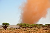
Droughts cause a range of impacts and are often worsened due to climate change. From top to bottom: a dry lakebed in California, which is in 2022 experiencing its most serious megadrought in 1,200 years; Sandstorm in Somaliland due to drought; drought and high temperatures worsened the 2020 bushfires in Australia.; Droughts negatively impact agriculture in Texas.

A drought is a period of drier-than-normal conditions. A drought can last for days, months or years. Drought often has large impacts on the ecosystems and agriculture of affected regions, and causes harm to the local economy. Annual dry seasons in the tropics significantly increase the chances of a drought developing and subsequent wildfires. Periods of heat can significantly worsen drought conditions by hastening evaporation of water vapour.

Drought is a recurring feature of the climate in most parts of the world, becoming more extreme and less predictable due to climate change, which dendrochronological studies date back to 1900. There are three kinds of drought effects, environmental, economic and social. Environmental effects include the drying of wetlands, more and larger wildfires, loss of biodiversity. Economic consequences include disruption of water supplies for municipal economies; lower agricultural, forest, game, and fishing outputs; higher food-production costs; and problems with water supply for the energy sector. Social and health costs include the negative effect on the health of people directly exposed to this phenomenon (excessive heat waves), high food costs, stress caused by failed harvests, water scarcity, etc. Prolonged droughts have caused mass migrations and humanitarian crisis.

Many plant species, such as those in the family Cactaceae (or cacti), have drought tolerance adaptations like reduced leaf area and waxy cuticles to enhance their ability to tolerate drought. Some others survive dry periods as buried seeds. Semi-permanent drought produces arid biomes such as deserts and grasslands. Most arid ecosystems have inherently low productivity.

The most prolonged drought ever in the world in recorded history continues in the Atacama Desert in Chile (400 years). Throughout history, humans have usually viewed droughts as "disasters" due to the impact on food availability and the rest of society. Humans have often tried to explain droughts as either a natural disaster, caused by humans, or the result of supernatural forces.

Definition

Fields outside Benambra, Australia suffering from drought conditions in 2006.

The IPCC Sixth Assessment Report defines a drought simply as "drier than normal conditions". This means that a drought is "a moisture deficit relative to the average water availability at a given location and season".

According to National Integrated Drought Information System, a multi-agency partnership, drought is generally defined as “a deficiency of precipitation over an extended period of time (usually a season or more), resulting in a water shortage”. The National Weather Service office of the NOAA defines drought as "a deficiency of moisture that results in adverse impacts on people, animals, or vegetation over a sizeable area".

Drought is a complex phenomenon − relating to the absence of water − which is difficult to monitor and define. By the early 1980's, over 150 definitions of "drought" had already been published. The range of definitions reflects differences in regions, needs, and disciplinary approaches.

Categories

There are three major categories of drought based on where in the water cycle the moisture deficit occurs: meteorological drought, hydrological drought, and agricultural or ecological drought. A meteorological drought occurs due to lack of precipitation. A hydrological drought is related to low runoff, streamflow, and reservoir storage. An agricultural or ecological drought is causing plant stress from a combination of evaporation and low soil moisture. Some organizations add another category: socioeconomic drought occurs when the demand for an economic good exceeds supply as a result of a weather-related shortfall in water supply. The socioeconomic drought is a similar concept to water scarcity.

The different categories of droughts have different causes but similar effects:

  1. Meteorological drought occurs when there is a prolonged time with less than average precipitation. Meteorological drought usually precedes the other kinds of drought. As a drought persists, the conditions surrounding it gradually worsen and its impact on the local population gradually increases.
  2. Hydrological drought is brought about when the water reserves available in sources such as aquifers, lakes and reservoirs fall below a locally significant threshold. Hydrological drought tends to show up more slowly because it involves stored water that is used but not replenished. Like an agricultural drought, this can be triggered by more than just a loss of rainfall. For instance, around 2007 Kazakhstan was awarded a large amount of money by the World Bank to restore water that had been diverted to other nations from the Aral Sea under Soviet rule. Similar circumstances also place their largest lake, Balkhash, at risk of completely drying out.
  3. Agricultural or ecological droughts affect crop production or ecosystems in general. This condition can also arise independently from any change in precipitation levels when either increased irrigation or soil conditions and erosion triggered by poorly planned agricultural endeavors cause a shortfall in water available to the crops.

Causes

Contraction/Desiccation cracks in the dry earth of the Sonoran desert, northwestern Mexico, near the U.S. state borders of California and Arizona

General precipitation deficiency

Mechanisms of producing precipitation include convective, stratiform, and orographic rainfall. Convective processes involve strong vertical motions that can cause the overturning of the atmosphere in that location within an hour and cause heavy precipitation, while stratiform processes involve weaker upward motions and less intense precipitation over a longer duration. Precipitation can be divided into three categories, based on whether it falls as liquid water, liquid water that freezes on contact with the surface, or ice. Droughts occur mainly in areas where normal levels of rainfall are, in themselves, low. If these factors do not support precipitation volumes sufficiently to reach the surface over a sufficient time, the result is a drought. Drought can be triggered by a high level of reflected sunlight and above average prevalence of high pressure systems, winds carrying continental, rather than oceanic air masses, and ridges of high pressure areas aloft can prevent or restrict the developing of thunderstorm activity or rainfall over one certain region. Once a region is within drought, feedback mechanisms such as local arid air, hot conditions which can promote warm core ridging, and minimal evapotranspiration can worsen drought conditions.

Dry season

Within the tropics, distinct, wet and dry seasons emerge due to the movement of the Intertropical Convergence Zone or Monsoon trough. The dry season greatly increases drought occurrence, and is characterized by its low humidity, with watering holes and rivers drying up. Because of the lack of these watering holes, many grazing animals are forced to migrate due to the lack of water in search of more fertile lands. Examples of such animals are zebras, elephants, and wildebeest. Because of the lack of water in the plants, bushfires are common. Since water vapor becomes more energetic with increasing temperature, more water vapor is required to increase relative humidity values to 100% at higher temperatures (or to get the temperature to fall to the dew point). Periods of warmth quicken the pace of fruit and vegetable production, increase evaporation and transpiration from plants, and worsen drought conditions.

El Niño–Southern Oscillation (ENSO)

Regional impacts of warm ENSO episodes (El Niño)

The El Niño–Southern Oscillation (ENSO) phenomenon can sometimes play a significant role in drought. ENSO comprises two patterns of temperature anomalies in the central Pacific Ocean, known as La Niña and El Niño. La Niña events are generally associated with drier and hotter conditions and further exacerbation of drought in California and the Southwestern United States, and to some extent the U.S. Southeast. Meteorological scientists have observed that La Niñas have become more frequent over time.

Conversely, during El Niño events, drier and hotter weather occurs in parts of the Amazon River Basin, Colombia, and Central America. Winters during the El Niño are warmer and drier than average conditions in the Northwest, northern Midwest, and northern Mideast United States, so those regions experience reduced snowfalls. Conditions are also drier than normal from December to February in south-central Africa, mainly in Zambia, Zimbabwe, Mozambique, and Botswana. Direct effects of El Niño resulting in drier conditions occur in parts of Southeast Asia and Northern Australia, increasing bush fires, worsening haze, and decreasing air quality dramatically. Drier-than-normal conditions are also in general observed in Queensland, inland Victoria, inland New South Wales, and eastern Tasmania from June to August. As warm water spreads from the west Pacific and the Indian Ocean to the east Pacific, it causes extensive drought in the western Pacific. Singapore experienced the driest February in 2014 since records began in 1869, with only 6.3 mm of rain falling in the month and temperatures hitting as high as 35 °C on 26 February. The years 1968 and 2005 had the next driest Februaries, when 8.4 mm of rain fell.

Impacts of climate change on soil moisture at 2 °C of global warming. A reduction of one standard deviation means that average soil moisture will approximate the ninth driest year between 1850 and 1900.

Precipitation deficiency due to climate change

The IPCC Sixth Assessment Report (2021) projected multiplicative increases in the frequency of extreme events compared to the pre-industrial era for heat waves, droughts and heavy precipitation events, for various climate change scenarios.

Global climate change is expected to trigger droughts with a substantial impact on agriculture throughout the world, and especially in developing nations. Along with drought in some areas, flooding and erosion could increase in others. Some proposed climate change mitigation actions that focus on more active techniques, solar radiation management through the use of a space sunshade for one, may also carry with them increased chances of drought.

There is a rise of compound warm-season droughts in Europe that are concurrent with an increase in potential evapotranspiration.

A dry lakebed in California. In 2022, the state was experiencing its most serious drought in 1,200 years, worsened by climate change.
 
Climate change affects multiple factors associated with droughts, such as how much rain falls and how fast the rain evaporates again. Warming over land increases the severity and frequency of droughts around much of the world. In some tropical and subtropical regions of the world, there will likely be less rain due to global warming, making them more prone to drought. These regions where droughts are set to worsen are Central America, the Amazon and south-western South America, West and Southern Africa, as well as the Mediterranean and south-western Australia.

Higher temperatures lead to increased evaporation, thus drying the soil and increasing plant stress, which will have impacts on agriculture. For this reason, even regions where overall rainfall is expected to remain relatively stable, such as central and northern Europe, will experience these impacts. Without climate change mitigation, it is expected that around a third of land areas will experience moderate or more severe drought by 2100. Droughts are likely to be more intense than in the past.

Due to limitations on how much data is available about drought in the past, it is often impossible to confidently attribute a specific drought to human-induced climate change. Some areas however, such as the Mediterranean and California, already show the impacts of human activities. Their impacts are made worse because of increased water demand, population growth, urban expansion, and environmental protection efforts in many areas. Land restoration, especially by agroforestry, can help reduce the impact of droughts.

Erosion and human activities

Human activity can directly trigger exacerbating factors such as over farming, excessive irrigation, deforestation, and erosion adversely impact the ability of the land to capture and hold water. In arid climates, the main source of erosion is wind. Erosion can be the result of material movement by the wind. The wind can cause small particles to be lifted and therefore moved to another region (deflation). Suspended particles within the wind may impact on solid objects causing erosion by abrasion (ecological succession). Wind erosion generally occurs in areas with little or no vegetation, often in areas where there is insufficient rainfall to support vegetation.

Loess is a homogeneous, typically nonstratified, porous, friable, slightly coherent, often calcareous, fine-grained, silty, pale yellow or buff, windblown (Aeolian) sediment. It generally occurs as a widespread blanket deposit that covers areas of hundreds of square kilometers and tens of meters thick. Loess often stands in either steep or vertical faces. Loess tends to develop into highly rich soils. Under appropriate climatic conditions, areas with loess are among the most agriculturally productive in the world. Loess deposits are geologically unstable by nature, and will erode very readily. Therefore, windbreaks (such as big trees and bushes) are often planted by farmers to reduce the wind erosion of loess. Wind erosion is much more severe in arid areas and during times of drought. For example, in the Great Plains, it is estimated that soil loss due to wind erosion can be as much as 6100 times greater in drought years than in wet years.

Consequences

Global drought total economic loss risk
 
Pair of dead oryx in Namibia during the 2018–19 Southern Africa drought.
 
After years of drought and dust storms the town of Farina in South Australia was abandoned.

One can divide the effects of droughts and water shortages into three groups: environmental, economic and social (including health).

  • In the case of environmental effects: lower surface and subterranean water-levels, lower flow-levels (with a decrease below the minimum leading to direct danger for amphibian life), increased pollution of surface water, the drying out of wetlands, more and larger wildfires, higher deflation intensity, loss of biodiversity, worse health of trees and the appearance of pests and dendroid diseases.
  • Economic losses include lower agricultural, forests, game and fishing output, higher food-production costs, lower energy-production levels in hydro plants, losses caused by depleted water tourism and transport revenue, problems with water supply for the energy sector and for technological processes in metallurgy, mining, the chemical, paper, wood, foodstuff industries etc., disruption of water supplies for municipal economies. The Global Commission of Economics of Water produced "The What, Why and How of the World Water Crisis" report for the UN Conference of Water 2023 to provide a ground work for understanding the economics of water and action on the water crisis.
  • Social and health costs include the negative effect on the health of people directly exposed to this phenomenon (excessive heat waves), possible limitation of water supplies, increased pollution levels, high food-costs, stress caused by failed harvests, water scarcity, etc. This explains why droughts and water scarcity operate as a factor which increases the gap between developed and developing countries.

Effects vary according to vulnerability. For example, subsistence farmers are more likely to migrate during drought because they do not have alternative food-sources. Areas with populations that depend on water sources as a major food-source are more vulnerable to famine.

Environmental and economic consequences

Common environmental and economic consequences of drought include:

Social and health consequences

Impacts on crops

Water stress affects plant development and quality in a variety of ways: firstly drought can cause poor germination and impaired seedling development. At the same time plant growth relies on cellular division, cell enlargement, and differentiation. Drought stress impairs mitosis and cell elongation via loss of turgor pressure which results in poor growth. Development of leaves is also dependent upon turgor pressure, concentration of nutrients, and carbon assimilates all of which are reduced by drought conditions, thus drought stress lead to a decrease in leaf size and number. Plant height, biomass, leaf size and stem girth has been shown to decrease in maize under water limiting conditions. Crop yield is also negatively effected by drought stress, the reduction in crop yield results from a decrease in photosynthetic rate, changes in leaf development, and altered allocation of resources all due to drought stress. Crop plants exposed to drought stress suffer from reductions in leaf water potential and transpiration rate. Water-use efficiency increases in crops such as wheat while decreasing in others, such as potatoes.

Plants need water for the uptake of nutrients from the soil, and for the transport of nutrients throughout the plant: drought conditions limit these functions leading to stunted growth. Drought stress also causes a decrease in photosynthetic activity in plants due to the reduction of photosynthetic tissues, stomatal closure, and reduced performance of photosynthetic machinery. This reduction in photosynthetic activity contributes to the reduction in plant growth and yields. Another factor influencing reduced plant growth and yields include the allocation of resources; following drought stress plants will allocate more resources to roots to aid in water uptake increasing root growth and reducing the growth of other plant parts while decreasing yields.

Protection, mitigation and relief

Succulent plants are well-adapted to survive long periods of drought.
 
Water distribution on Marshall Islands during El Niño.

Agriculturally, people can effectively mitigate much of the impact of drought through irrigation and crop rotation. Failure to develop adequate drought mitigation strategies carries a grave human cost in the modern era, exacerbated by ever-increasing population densities. President Roosevelt on April 27, 1935, signed documents creating the Soil Conservation Service (SCS)—now the Natural Resources Conservation Service (NRCS). Models of the law were sent to each state where they were enacted. These were the first enduring practical programs to curtail future susceptibility to drought, creating agencies that first began to stress soil conservation measures to protect farm lands today. It was not until the 1950s that there was an importance placed on water conservation was put into the existing laws (NRCS 2014).

Strategies for drought protection, mitigation or relief include:

  • Dams – many dams and their associated reservoirs supply additional water in times of drought.
  • Cloud seeding – a form of intentional weather modification to induce rainfall. This remains a hotly debated topic, as the United States National Research Council released a report in 2004 stating that to date, there is still no convincing scientific proof of the efficacy of intentional weather modification.
  • Desalination – use of sea water for irrigation or consumption.
  • Drought monitoring – Continuous observation of rainfall levels and comparisons with current usage levels can help prevent man-made drought. For instance, analysis of water usage in Yemen has revealed that their water table (underground water level) is put at grave risk by over-use to fertilize their Khat crop. Careful monitoring of moisture levels can also help predict increased risk for wildfires, using such metrics as the Keetch-Byram Drought Index or Palmer Drought Index.
  • Land use – Carefully planned crop rotation can help to minimize erosion and allow farmers to plant less water-dependent crops in drier years.
  • Outdoor water-use restriction – Regulating the use of sprinklers, hoses or buckets on outdoor plants, filling pools, and other water-intensive home maintenance tasks. Xeriscaping yards can significantly reduce unnecessary water use by residents of towns and cities.
  • Rainwater harvesting – Collection and storage of rainwater from roofs or other suitable catchments.
  • Recycled water – Former wastewater (sewage) that has been treated and purified for reuse.
  • Transvasement – Building canals or redirecting rivers as massive attempts at irrigation in drought-prone areas.

Scale and examples

Some large scale droughts in the 21st century included:

  • The 1997–2009 Millennium Drought in Australia led to a water supply crisis across much of the country. As a result, many desalination plants were built for the first time (see list).
  • In 2006, Sichuan Province China experienced its worst drought in modern times with nearly 8 million people and over 7 million cattle facing water shortages.
  • 12-year drought that was devastating southwest Western Australia, southeast South Australia, Victoria and northern Tasmania was "very severe and without historical precedent".
  • 2015–2018 Cape Town water crisis. This likelihood was tripled by climate change.
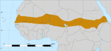
Affected areas in the western Sahel belt during the 2012 drought.

The Darfur conflict in Sudan, also affecting Chad, was fueled by decades of drought; combination of drought, desertification and overpopulation are among the causes of the Darfur conflict, because the Arab Baggara nomads searching for water have to take their livestock further south, to land mainly occupied by non-Arab farming people.

Drought-affected area in Karnataka, India in 2012.

Approximately 2.4 billion people live in the drainage basin of the Himalayan rivers. India, China, Pakistan, Bangladesh, Nepal and Myanmar could experience floods followed by droughts in coming decades. Drought in India affecting the Ganges is of particular concern, as it provides drinking water and agricultural irrigation for more than 500 million people. The west coast of North America, which gets much of its water from glaciers in mountain ranges such as the Rocky Mountains and Sierra Nevada, also would be affected.

In 2005, parts of the Amazon basin experienced the worst drought in 100 years. A 23 July 2006 article reported Woods Hole Research Center results showing that the forest in its present form could survive only three years of drought. Scientists at the Brazilian National Institute of Amazonian Research argue in the article that this drought response, coupled with the effects of deforestation on regional climate, are pushing the rainforest towards a "tipping point" where it would irreversibly start to die. It concludes that the rainforest is on the brink of being turned into savanna or desert, with catastrophic consequences for the world's climate. According to the WWF, the combination of climate change and deforestation increases the drying effect of dead trees that fuels forest fires.

Lake Chad in a 2001 satellite image. The lake has shrunk by 95% since the 1960s.

By far the largest part of Australia is desert or semi-arid lands commonly known as the outback. A 2005 study by Australian and American researchers investigated the desertification of the interior, and suggested that one explanation was related to human settlers who arrived about 50,000 years ago. Regular burning by these settlers could have prevented monsoons from reaching interior Australia. In June 2008 it became known that an expert panel had warned of long term, maybe irreversible, severe ecological damage for the whole Murray-Darling basin if it did not receive sufficient water by October 2008. Australia could experience more severe droughts and they could become more frequent in the future, a government-commissioned report said on July 6, 2008. Australian environmentalist Tim Flannery, predicted that unless it made drastic changes, Perth in Western Australia could become the world's first ghost metropolis, an abandoned city with no more water to sustain its population. The long Australian Millennial drought broke in 2010.

Recurring droughts leading to desertification in East Africa have created grave ecological catastrophes, prompting food shortages in 1984–85, 2006 and 2011. During the 2011 drought, an estimated 50,000 to 150,000 people were reported to have died, though these figures and the extent of the crisis are disputed. In February 2012, the UN announced that the crisis was over due to a scaling up of relief efforts and a bumper harvest. Aid agencies subsequently shifted their emphasis to recovery efforts, including digging irrigation canals and distributing plant seeds. The 2020-2022 Horn of Africa drought has surpassed the horrific drought in 2010-2011 in both duration and severity.

In 2012, a severe drought struck the western Sahel. The Methodist Relief & Development Fund (MRDF) reported that more than 10 million people in the region were at risk of famine due to a month-long heat wave that was hovering over Niger, Mali, Mauritania and Burkina Faso. A fund of about £20,000 was distributed to the drought-hit countries.

History

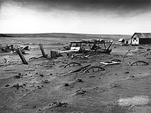
A South Dakota farm during the Dust Bowl, 1936
 

Throughout history, humans have usually viewed droughts as "disasters" due to the impact on food availability and the rest of society. Humans have often tried to explain droughts as either a natural disaster, caused by humans, or the result of supernatural forces. It is among the earliest documented climatic events, present in the Epic of Gilgamesh and tied to the Biblical story of Joseph's arrival in and the later Exodus from ancient Egypt. Hunter-gatherer migrations in 9,500 BC Chile have been linked to the phenomenon, as has the exodus of early humans out of Africa and into the rest of the world around 135,000 years ago. Rituals exist to prevent or avert drought, rainmaking could go from dances to scapegoating to human sacrifices. Nowadays, those ancient practices are for the most part relegated to folklore and replaced by more rational water management.

Historical droughts include:

  • 1540 Central Europe, said to be the “worst drought of the millennium” with eleven months without rain and temperatures of 5–7 °C above the average of the 20th century
  • 1900 India killing between 250,000 and 3.25 million.
  • 1921–22 Soviet Union in which over 5 million perished from starvation due to drought.
  • 1928–30 Northwest China resulting in over 3 million deaths by famine.
  • 1936 and 1941 Sichuan Province China resulting in 5 million and 2.5 million deaths respectively.

Flood

https://en.wikipedia.org/wiki/Flood

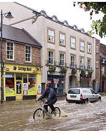
Flooding in a street in Morpeth, England. Flooding is increasing with extreme weather events caused by climate change are creating rainfall events with much more rain than in the past. Cities and towns built on waterbodies or with infrastructure designed around historical rainfall patterns are increasingly susceptible to urban flooding.

A flood is an overflow of water (or rarely other fluids) that submerges land that is usually dry. In the sense of "flowing water", the word may also be applied to the inflow of the tide. Floods are an area of study of the discipline hydrology and are of significant concern in agriculture, civil engineering and public health. Human changes to the environment often increase the intensity and frequency of flooding, for example land use changes such as deforestation and removal of wetlands, changes in waterway course or flood controls such as with levees, and larger environmental issues such as climate change and sea level rise. In particular climate change's increased rainfall and extreme weather events increases the severity of other causes for flooding, resulting in more intense floods and increased flood risk.

Flooding may occur as an overflow of water from water bodies, such as a river, lake, or ocean, in which the water overtops or breaks levees, resulting in some of that water escaping its usual boundaries, or it may occur due to an accumulation of rainwater on saturated ground in an areal flood. While the size of a lake or other body of water will vary with seasonal changes in precipitation and snow melt, these changes in size are unlikely to be considered significant unless they flood property or drown domestic animals.

Floods can also occur in rivers when the flow rate exceeds the capacity of the river channel, particularly at bends or meanders in the waterway. Floods often cause damage to homes and businesses if they are in the natural flood plains of rivers. While riverine flood damage can be eliminated by moving away from rivers and other bodies of water, people have traditionally lived and worked by rivers because the land is usually flat and fertile and because rivers provide easy travel and access to commerce and industry. Flooding can lead to secondary consequences in addition to damage to property, such as long-term displacement of residents and creating increased spread of waterborne diseases and vector-bourne disesases transmitted by mosquitos.

Types

Contemporary picture of the flood that struck the North Sea coast of Germany and Denmark in October 1634.
 
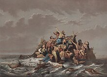
People seeking refuge from flood in Java, ca. 1865–1876.
 
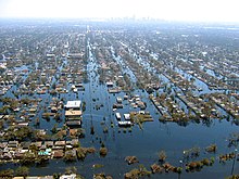
View of flooded New Orleans in the aftermath of Hurricane Katrina. New Orleans has historically been vulnerable to flooding because it is on a river delta and experiences hurricanes. Katrina's extreme rainfall and poor infrastructure maintenance led to a levee breach which flooded large portions of the city.
 
"Regular" flooding in Venice, Italy.
 
Flooding of a creek due to heavy monsoonal rain and high tide in Darwin, Northern Territory, Australia.
 
Flood in Jeddah, covering the King Abdullah Street in Saudi Arabia.

Areal

In spring time, the floods are quite typical in Ostrobothnia, a flat-lying area in Finland. A flood-surrounded house in Ilmajoki, South Ostrobothnia.

Floods can happen on flat or low-lying areas when water is supplied by rainfall or snowmelt more rapidly than it can either infiltrate or run off. The excess accumulates in place, sometimes to hazardous depths. Surface soil can become saturated, which effectively stops infiltration, where the water table is shallow, such as a floodplain, or from intense rain from one or a series of storms. Infiltration also is slow to negligible through frozen ground, rock, concrete, paving, or roofs. Areal flooding begins in flat areas like floodplains and in local depressions not connected to a stream channel, because the velocity of overland flow depends on the surface slope. Endorheic basins may experience areal flooding during periods when precipitation exceeds evaporation.

Riverine (Channel)

Floods occur in all types of river and stream channels, from the smallest ephemeral streams in humid zones to normally-dry channels in arid climates to the world's largest rivers. When overland flow occurs on tilled fields, it can result in a muddy flood where sediments are picked up by run off and carried as suspended matter or bed load. Localized flooding may be caused or exacerbated by drainage obstructions such as landslides, ice, debris, or beaver dams.

Slow-rising floods most commonly occur in large rivers with large catchment areas. The increase in flow may be the result of sustained rainfall, rapid snow melt, monsoons, or tropical cyclones. However, large rivers may have rapid flooding events in areas with dry climate, since they may have large basins but small river channels and rainfall can be very intense in smaller areas of those basins.

Rapid flooding events, including flash floods, more often occur on smaller rivers, rivers with steep valleys, rivers that flow for much of their length over impermeable terrain, or normally-dry channels. The cause may be localized convective precipitation (intense thunderstorms) or sudden release from an upstream impoundment created behind a dam, landslide, or glacier. In one instance, a flash flood killed eight people enjoying the water on a Sunday afternoon at a popular waterfall in a narrow canyon. Without any observed rainfall, the flow rate increased from about 50 to 1,500 cubic feet per second (1.4 to 42 m3/s) in just one minute. Two larger floods occurred at the same site within a week, but no one was at the waterfall on those days. The deadly flood resulted from a thunderstorm over part of the drainage basin, where steep, bare rock slopes are common and the thin soil was already saturated.

Flash floods are the most common flood type in normally-dry channels in arid zones, known as arroyos in the southwest United States and many other names elsewhere. In that setting, the first flood water to arrive is depleted as it wets the sandy stream bed. The leading edge of the flood thus advances more slowly than later and higher flows. As a result, the rising limb of the hydrograph becomes ever quicker as the flood moves downstream, until the flow rate is so great that the depletion by wetting soil becomes insignificant.

Estuarine and coastal

Flooding in estuaries is commonly caused by a combination of storm surges caused by winds and low barometric pressure and large waves meeting high upstream river flows.

Coastal areas may be flooded by storm surges combining with high tides and large wave events at sea, resulting in waves over-topping flood defenses or in severe cases by tsunami or tropical cyclones. A storm surge, from either a tropical cyclone or an extratropical cyclone, falls within this category. Research from the NHC (National Hurricane Center) explains: "Storm surge is an additional rise of water generated by a storm, over and above the predicted astronomical tides. Storm surge should not be confused with storm tide, which is defined as the water level rise due to the combination of storm surge and the astronomical tide. This rise in water level can cause extreme flooding in coastal areas particularly when storm surge coincides with spring tide, resulting in storm tides reaching up to 20 feet or more in some cases."

Urban flooding

Flooding on Water Street in Toledo, Ohio, 1881

Urban flooding is the inundation of land or property in a built environment, particularly in more densely populated areas, caused by rainfall overwhelming the capacity of drainage systems, such as storm sewers. Although sometimes triggered by events such as flash flooding or snowmelt, urban flooding is a condition, characterized by its repetitive and systemic impacts on communities, that can happen regardless of whether or not affected communities are located within designated floodplains or near any body of water. Aside from potential overflow of rivers and lakes, snowmelt, stormwater or water released from damaged water mains may accumulate on property and in public rights-of-way, seep through building walls and floors, or backup into buildings through sewer pipes, toilets and sinks.

In urban areas, flood effects can be exacerbated by existing paved streets and roads, which increase the speed of flowing water. Impervious surfaces prevent rainfall from infiltrating into the ground, thereby causing a higher surface run-off that may be in excess of local drainage capacity.

The flood flow in urbanized areas constitutes a hazard to both the population and infrastructure. Some recent catastrophes include the inundations of Nîmes (France) in 1998 and Vaison-la-Romaine (France) in 1992, the flooding of New Orleans (USA) in 2005, and the flooding in Rockhampton, Bundaberg, Brisbane during the 2010–2011 summer in Queensland (Australia). Flood flows in urban environments have been studied relatively recently despite many centuries of flood events. Some recent research has considered the criteria for safe evacuation of individuals in flooded areas.

Catastrophic

Catastrophic riverine flooding is usually associated with major infrastructure failures such as the collapse of a dam, but they may also be caused by drainage channel modification from a landslide, earthquake or volcanic eruption. Examples include outburst floods and lahars. Tsunamis can cause catastrophic coastal flooding, most commonly resulting from undersea earthquakes.

Causes

Upslope factors

The amount, location, and timing of water reaching a drainage channel from natural precipitation and controlled or uncontrolled reservoir releases determines the flow at downstream locations. Some precipitation evaporates, some slowly percolates through soil, some may be temporarily sequestered as snow or ice, and some may produce rapid runoff from surfaces including rock, pavement, roofs, and saturated or frozen ground. The fraction of incident precipitation promptly reaching a drainage channel has been observed from nil for light rain on dry, level ground to as high as 170 percent for warm rain on accumulated snow.

Most precipitation records are based on a measured depth of water received within a fixed time interval. Frequency of a precipitation threshold of interest may be determined from the number of measurements exceeding that threshold value within the total time period for which observations are available. Individual data points are converted to intensity by dividing each measured depth by the period of time between observations. This intensity will be less than the actual peak intensity if the duration of the rainfall event was less than the fixed time interval for which measurements are reported. Convective precipitation events (thunderstorms) tend to produce shorter duration storm events than orographic precipitation. Duration, intensity, and frequency of rainfall events are important to flood prediction. Short duration precipitation is more significant to flooding within small drainage basins.

The most important upslope factor in determining flood magnitude is the land area of the watershed upstream of the area of interest. Rainfall intensity is the second most important factor for watersheds of less than approximately 30 square miles or 80 square kilometres. The main channel slope is the second most important factor for larger watersheds. Channel slope and rainfall intensity become the third most important factors for small and large watersheds, respectively.

Time of Concentration is the time required for runoff from the most distant point of the upstream drainage area to reach the point of the drainage channel controlling flooding of the area of interest. The time of concentration defines the critical duration of peak rainfall for the area of interest. The critical duration of intense rainfall might be only a few minutes for roof and parking lot drainage structures, while cumulative rainfall over several days would be critical for river basins.

Downslope factors

Water flowing downhill ultimately encounters downstream conditions slowing movement. The final limitation in coastal flooding lands is often the ocean or some coastal flooding bars which form natural lakes. In flooding low lands, elevation changes such as tidal fluctuations are significant determinants of coastal and estuarine flooding. Less predictable events like tsunamis and storm surges may also cause elevation changes in large bodies of water. Elevation of flowing water is controlled by the geometry of the flow channel and, especially, by depth of channel, speed of flow and amount of sediments in it. Flow channel restrictions like bridges and canyons tend to control water elevation above the restriction. The actual control point for any given reach of the drainage may change with changing water elevation, so a closer point may control for lower water levels until a more distant point controls at higher water levels.

Effective flood channel geometry may be changed by growth of vegetation, accumulation of ice or debris, or construction of bridges, buildings, or levees within the flood channel.

Coincidence

Extreme flood events often result from coincidence such as unusually intense, warm rainfall melting heavy snow pack, producing channel obstructions from floating ice, and releasing small impoundments like beaver dams. Coincident events may cause extensive flooding to be more frequent than anticipated from simplistic statistical prediction models considering only precipitation runoff flowing within unobstructed drainage channels. Debris modification of channel geometry is common when heavy flows move uprooted woody vegetation and flood-damaged structures and vehicles, including boats and railway equipment. Recent field measurements during the 2010–11 Queensland floods showed that any criterion solely based upon the flow velocity, water depth or specific momentum cannot account for the hazards caused by velocity and water depth fluctuations. These considerations ignore further the risks associated with large debris entrained by the flow motion.

Some researchers have mentioned the storage effect in urban areas with transportation corridors created by cut and fill. Culverted fills may be converted to impoundments if the culverts become blocked by debris, and flow may be diverted along streets. Several studies have looked into the flow patterns and redistribution in streets during storm events and the implication on flood modelling.

Climate change

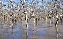
Flooded walnut orchards in Butte County after several atmospheric rivers hit California in early 2023

Due to an increase in heavy rainfall events, floods are expected to become more severe when they do occur. However, the interactions between rainfall and flooding are complex. There are some regions in which flooding is expected to become rarer. This depends on several factors, such as changes in rain and snowmelt, but also soil moisture.

Sea level rise further increases risks of coastal flooding: with substantial disruption projected for cities, settlements and infrastructure on coasts.

Intentional flooding

The intentional flooding of land that would otherwise remain dry may take place for military, agricultural, or river-management purposes. This is a form of hydraulic engineering.

Agricultural flooding may occur in preparing paddy fields for the growing of semi-aquatic rice in many countries.

Flooding for river management may occur in the form of diverting flood waters in a river at flood stage upstream from areas that are considered more valuable than the areas that are sacrificed in this way. This may be done ad hoc, as in the 2011 intentional breach of levees by the United States Army Corps of Engineers in Missouri, or permanently, as in the so-called overlaten (literally "let-overs"), an intentionally lowered segment in Dutch riparian levees, like the Beerse Overlaat in the left levee of the Meuse between the villages of Gassel and Linden, North Brabant.

Military inundation creates an obstacle in the field that is intended to impede the movement of the enemy. This may be done both for offensive and defensive purposes. Furthermore, in so far as the methods used are a form of hydraulic engineering, it may be useful to differentiate between controlled inundations (as in most historic inundations in the Netherlands under the Dutch Republic and its successor states in that area and exemplified in the two Hollandic Water Lines, the Stelling van Amsterdam, the Frisian Water Line, the IJssel Line, the Peel-Raam Line, and the Grebbe line in that country) and uncontrolled ones (as in the second Siege of Leiden during the first part of the Eighty Years' War, and the Inundation of Walcheren, and the Inundation of the Wieringermeer during the Second World War). To count as controlled, a military inundation has to take the interests of the civilian population into account, by allowing them a timely evacuation, by making the inundation reversible, and by making an attempt to minimize the adverse ecological impact of the inundation. That impact may also be adverse in a hydrogeological sense if the inundation lasts a long time.

Effects

Floods can also be a huge destructive power. When water flows, it has the ability to demolish all kinds of buildings and objects, such as bridges, structures, houses, trees, cars... For example, in Bangladesh in 2007, a flood was responsible for the destruction of more than one million houses. And yearly in the United States, floods cause over $7 billion in damage.

Primary effects

The primary effects of flooding include loss of life and damage to buildings and other structures, including bridges, sewerage systems, roadways, and canals.

A dog sitting on top of 2 feet of mud deposited by flooding in the 2018 Kerala floods in India. Flooding not only creates water damage, but can also deposit large amounts of sediment.

Floods also frequently damage power transmission and sometimes power generation, which then has knock-on effects caused by the loss of power. This includes loss of drinking water treatment and water supply, which may result in loss of drinking water or severe water contamination. It may also cause the loss of sewage disposal facilities. Lack of clean water combined with human sewage in the flood waters raises the risk of waterborne diseases, which can include typhoid, giardia, cryptosporidium, cholera and many other diseases depending upon the location of the flood.

Damage to roads and transport infrastructure may make it difficult to mobilize aid to those affected or to provide emergency health treatment.

Flood waters typically inundate farm land, making the land unworkable and preventing crops from being planted or harvested, which can lead to shortages of food both for humans and farm animals. Entire harvests for a country can be lost in extreme flood circumstances. Some tree species may not survive prolonged flooding of their root systems.

Health effects

Fatalities connected directly to floods are usually caused by drowning; the waters in a flood are very deep and have strong currents. Deaths do not just occur from drowning, deaths are connected with dehydration, heat stroke, heart attack and any other illness that needs medical supplies that cannot be delivered.

Injuries can lead to an excessive amount of morbidity when a flood occurs. Injuries are not isolated to just those who were directly in the flood, rescue teams and even people delivering supplies can sustain an injury. Injuries can occur anytime during the flood process; before, during and after. During floods accidents occur with falling debris or any of the many fast moving objects in the water. After the flood rescue attempts are where large numbers injuries can occur.

Communicable diseases are increased due to many pathogens and bacteria that are being transported by the water.There are many waterborne diseases such as cholera, hepatitis A, hepatitis E and diarrheal diseases, to mention a few. Gastrointestinal disease and diarrheal diseases are very common due to a lack of clean water during a flood. Most of clean water supplies are contaminated when flooding occurs. Hepatitis A and E are common because of the lack of sanitation in the water and in living quarters depending on where the flood is and how prepared the community is for a flood.

When floods hit, people lose nearly their crops, livestock, and food reserves and face starvation.

Coastal flooding in a Florida community.

Urban flooding can cause chronically wet houses, leading to the growth of indoor mold and resulting in adverse health effects, particularly respiratory symptoms. Respiratory diseases are a common after the disaster has occurred. This depends on the amount of water damage and mold that grows after an incident. Research suggests that there will be an increase of 30–50% in adverse respiratory health outcomes caused by dampness and mold exposure for those living in coastal and wetland areas. Fungal contamination in homes is associated with increased allergic rhinitis and asthma. Vector borne diseases increase as well due to the increase in still water after the floods have settled. The diseases that are vector borne are malaria, dengue, West Nile, and yellow fever. Floods have a huge impact on victims' psychosocial integrity. People suffer from a wide variety of losses and stress. One of the most treated illness in long-term health problems are depression caused by the flood and all the tragedy that flows with one.

Loss of life

Below is a list of the deadliest floods worldwide, showing events with death tolls at or above 100,000 individuals.

Death toll Event Location Year
2,500,000–3,700,000 1931 China floods China 1931
900,000–2,000,000 1887 Yellow River flood China 1887
500,000–700,000 1938 Yellow River flood China 1938
231,000 Banqiao Dam failure, result of Typhoon Nina. Approximately 86,000 people died from flooding and another 145,000 died during subsequent disease. China 1975
230,000 2004 Indian Ocean tsunami Indonesia 2004
145,000 1935 Yangtze river flood China 1935
100,000+ St. Felix's flood, storm surge Netherlands 1530
100,000 Hanoi and Red River Delta flood North Vietnam 1971
100,000 1911 Yangtze river flood China 1911

Secondary and long-term effects

Flooding after 1991 Bangladesh cyclone, which killed around 140,000 people.
 
Flooding near Key West, Florida, United States from Hurricane Wilma's storm surge in October 2005.
 
Flooding in a street of Natal, Rio Grande do Norte, Brazil in April 2013.
 
Minor flooding in a parking lot off Juniper street Atlanta on Christmas Eve from thunderstorms caused by an El Nino event. The same El Nino caused recorded highs for January in Atlanta
 
Flash flooding caused by heavy rain falling in a short amount of time.
 
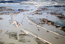
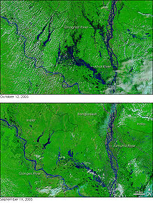
Dozens of villages were inundated when rain pushed the rivers of northwestern Bangladesh over their banks in early October 2005. The Moderate Resolution Imaging Spectroradiometer (MODIS) on NASA's Terra satellite captured the top image of the flooded Ghaghat and Atrai Rivers on October 12, 2005. The deep blue of the rivers is spread across the countryside in the flood image.

Economic hardship due to a temporary decline in tourism, rebuilding costs, or food shortages leading to price increases is a common after-effect of severe flooding. The impact on those affected may cause psychological damage to those affected, in particular where deaths, serious injuries and loss of property occur.

Urban flooding also has significant economic implications for affected neighborhoods. In the United States, industry experts estimate that wet basements can lower property values by 10–25 percent and are cited among the top reasons for not purchasing a home. According to the U.S. Federal Emergency Management Agency (FEMA), almost 40 percent of small businesses never reopen their doors following a flooding disaster. In the United States, insurance is available against flood damage to both homes and businesses.

Benefits

Floods (in particular more frequent or smaller floods) can also bring many benefits, such as recharging ground water, making soil more fertile and increasing nutrients in some soils. Flood waters provide much needed water resources in arid and semi-arid regions where precipitation can be very unevenly distributed throughout the year and kills pests in the farming land. Freshwater floods particularly play an important role in maintaining ecosystems in river corridors and are a key factor in maintaining floodplain biodiversity. Flooding can spread nutrients to lakes and rivers, which can lead to increased biomass and improved fisheries for a few years.

For some fish species, an inundated floodplain may form a highly suitable location for spawning with few predators and enhanced levels of nutrients or food. Fish, such as the weather fish, make use of floods in order to reach new habitats. Bird populations may also profit from the boost in food production caused by flooding.

Periodic flooding was essential to the well-being of ancient communities along the Tigris-Euphrates Rivers, the Nile River, the Indus River, the Ganges and the Yellow River among others. The viability of hydropower, a renewable source of energy, is also higher in flood prone regions.

Flood safety planning

Aftermath of flooding in Colorado, 2013
 
Flood rescue in Nangarhar, Afghanistan in 2010, accompanied by the Afghan Air Force and USAF air advisors

In the United States, the National Weather Service gives out the advice "Turn Around, Don't Drown" for floods; that is, it recommends that people get out of the area of a flood, rather than trying to cross it. At the most basic level, the best defense against floods is to seek higher ground for high-value uses while balancing the foreseeable risks with the benefits of occupying flood hazard zones. Critical community-safety facilities, such as hospitals, emergency-operations centers, and police, fire, and rescue services, should be built in areas least at risk of flooding. Structures, such as bridges, that must unavoidably be in flood hazard areas should be designed to withstand flooding. Areas most at risk for flooding could be put to valuable uses that could be abandoned temporarily as people retreat to safer areas when a flood is imminent.

Planning for flood safety involves many aspects of analysis and engineering, including:

  • observation of previous and present flood heights and inundated areas,
  • statistical, hydrologic, and hydraulic model analyses,
  • mapping inundated areas and flood heights for future flood scenarios,
  • long-term land use planning and regulation,
  • engineering design and construction of structures to control or withstand flooding,
  • intermediate-term monitoring, forecasting, and emergency-response planning, and
  • short-term monitoring, warning, and response operations.

Each topic presents distinct yet related questions with varying scope and scale in time, space, and the people involved. Attempts to understand and manage the mechanisms at work in floodplains have been made for at least six millennia.

In the United States, the Association of State Floodplain Managers works to promote education, policies, and activities that mitigate current and future losses, costs, and human suffering caused by flooding and to protect the natural and beneficial functions of floodplains – all without causing adverse impacts. A portfolio of best practice examples for disaster mitigation in the United States is available from the Federal Emergency Management Agency.

Control

In many countries around the world, waterways prone to floods are often carefully managed. Defenses such as detention basins, levees, bunds, reservoirs, and weirs are used to prevent waterways from overflowing their banks. When these defenses fail, emergency measures such as sandbags or portable inflatable tubes are often used to try to stem flooding. Coastal flooding has been addressed in portions of Europe and the Americas with coastal defenses, such as sea walls, beach nourishment, and barrier islands.

In the riparian zone near rivers and streams, erosion control measures can be taken to try to slow down or reverse the natural forces that cause many waterways to meander over long periods of time. Flood controls, such as dams, can be built and maintained over time to try to reduce the occurrence and severity of floods as well. In the United States, the U.S. Army Corps of Engineers maintains a network of such flood control dams.

In areas prone to urban flooding, one solution is the repair and expansion of man-made sewer systems and stormwater infrastructure. Another strategy is to reduce impervious surfaces in streets, parking lots and buildings through natural drainage channels, porous paving, and wetlands (collectively known as green infrastructure or sustainable urban drainage systems (SUDS)). Areas identified as flood-prone can be converted into parks and playgrounds that can tolerate occasional flooding. Ordinances can be adopted to require developers to retain stormwater on site and require buildings to be elevated, protected by floodwalls and levees, or designed to withstand temporary inundation. Property owners can also invest in solutions themselves, such as re-landscaping their property to take the flow of water away from their building and installing rain barrels, sump pumps, and check valves.

In some areas, the presence of certain species (such as beavers) can be beneficial for flood control reasons. Beavers build and maintain beaver dams which will reduce the height of flood waves moving down the river (during periods of heavy rains), and will reduce or eliminate damage to human structures, at the cost of minor flooding near the dams (often on farmland). Besides this, they also boost wildlife populations and filter pollutants (manure, fertilisers, slurry). UK environment minister Rebecca Pow stated that in the future the beavers could be considered a "public good" and landowners would be paid to have them on their land.

Flood risk management

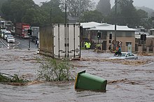
"Regular" flooding in Venice, Italy.
 
Flood risk management (FRM) aims to reduce the human and socio-economic losses caused by flooding and is part of the larger field of risk management. Flood risk management analyzes the relationships between physical systems and socio-economic environments through flood risk assessment and tries to create understanding and action about the risks posed by flooding. The relationships cover a wide range of topics, from drivers and natural processes, to models and socio-economic consequences. 

This relationship examines management methods which includes a wide range of flood management methods including but are not limited to flood mapping and physical implication measures. FRM looks at how to reduce flood risk and how to appropriately manage risks that are associated with flooding. Flood risk management includes mitigating and preparing for flooding disasters, analyzing risk, and providing a risk analysis system to mitigate the negative impacts caused by flooding.

Flooding and flood risk are especially important with more extreme weather and sea level rise caused by climate change as more areas will be effected by flood risk.

Analysis of flood information

A series of annual maximum flow rates in a stream reach can be analyzed statistically to estimate the 100-year flood and floods of other recurrence intervals there. Similar estimates from many sites in a hydrologically similar region can be related to measurable characteristics of each drainage basin to allow indirect estimation of flood recurrence intervals for stream reaches without sufficient data for direct analysis.

Physical process models of channel reaches are generally well understood and will calculate the depth and area of inundation for given channel conditions and a specified flow rate, such as for use in floodplain mapping and flood insurance. Conversely, given the observed inundation area of a recent flood and the channel conditions, a model can calculate the flow rate. Applied to various potential channel configurations and flow rates, a reach model can contribute to selecting an optimum design for a modified channel. Various reach models are available as of 2015, either 1D models (flood levels measured in the channel) or 2D models (variable flood depths measured across the extent of a floodplain). HEC-RAS, the Hydraulic Engineering Center model, is among the most popular software, if only because it is available free of charge. Other models such as TUFLOW combine 1D and 2D components to derive flood depths across both river channels and the entire floodplain.

Physical process models of complete drainage basins are even more complex. Although many processes are well understood at a point or for a small area, others are poorly understood at all scales, and process interactions under normal or extreme climatic conditions may be unknown. Basin models typically combine land-surface process components (to estimate how much rainfall or snowmelt reaches a channel) with a series of reach models. For example, a basin model can calculate the runoff hydrograph that might result from a 100-year storm, although the recurrence interval of a storm is rarely equal to that of the associated flood. Basin models are commonly used in flood forecasting and warning, as well as in analysis of the effects of land use change and climate change.

Flood forecasting

Anticipating floods before they occur allows for precautions to be taken and people to be warned so that they can be prepared in advance for flooding conditions. For example, farmers can remove animals from low-lying areas and utility services can put in place emergency provisions to re-route services if needed. Emergency services can also make provisions to have enough resources available ahead of time to respond to emergencies as they occur. People can evacuate areas to be flooded.

In order to make the most accurate flood forecasts for waterways, it is best to have a long time-series of historical data that relates stream flows to measured past rainfall events. Coupling this historical information with real-time knowledge about volumetric capacity in catchment areas, such as spare capacity in reservoirs, ground-water levels, and the degree of saturation of area aquifers is also needed in order to make the most accurate flood forecasts.

Radar estimates of rainfall and general weather forecasting techniques are also important components of good flood forecasting. In areas where good quality data is available, the intensity and height of a flood can be predicted with fairly good accuracy and plenty of lead time. The output of a flood forecast is typically a maximum expected water level and the likely time of its arrival at key locations along a waterway, and it also may allow for the computation of the likely statistical return period of a flood. In many developed countries, urban areas at risk of flooding are protected against a 100-year flood – that is a flood that has a probability of around 63% of occurring in any 100-year period of time.

According to the U.S. National Weather Service (NWS) Northeast River Forecast Center (RFC) in Taunton, Massachusetts, a rule of thumb for flood forecasting in urban areas is that it takes at least 1 inch (25 mm) of rainfall in around an hour's time in order to start significant ponding of water on impermeable surfaces. Many NWS RFCs routinely issue Flash Flood Guidance and Headwater Guidance, which indicate the general amount of rainfall that would need to fall in a short period of time in order to cause flash flooding or flooding on larger water basins.

In the United States, an integrated approach to real-time hydrologic computer modelling uses observed data from the U.S. Geological Survey (USGS), various cooperative observing networks, various automated weather sensors, the NOAA National Operational Hydrologic Remote Sensing Center (NOHRSC), various hydroelectric companies, etc. combined with quantitative precipitation forecasts (QPF) of expected rainfall and/or snow melt to generate daily or as-needed hydrologic forecasts. The NWS also cooperates with Environment Canada on hydrologic forecasts that affect both the US and Canada, like in the area of the Saint Lawrence Seaway.
The Global Flood Monitoring System, "GFMS", a computer tool which maps flood conditions worldwide, is available online. Users anywhere in the world can use GFMS to determine when floods may occur in their area. GFMS uses precipitation data from NASA's Earth observing satellites and the Global Precipitation Measurement satellite, "GPM". Rainfall data from GPM is combined with a land surface model that incorporates vegetation cover, soil type, and terrain to determine how much water is soaking into the ground, and how much water is flowing into streamflow.

Users can view statistics for rainfall, streamflow, water depth, and flooding every 3 hours, at each 12-kilometer gridpoint on a global map. Forecasts for these parameters are 5 days into the future. Users can zoom in to see inundation maps (areas estimated to be covered with water) in 1-kilometer resolution.

Society and culture

Myths and religion

Legends of great, civilization-destroying floods are widespread in many cultures. Flood events in the form of divine retribution have also been described in religious texts. The Genesis flood narrative plays a prominent role in Judaism, Christianity and Islam.

Etymology

The word "flood" comes from the Old English flōd, a word common to Germanic languages (compare German Flut, Dutch vloed from the same root as is seen in flow, float; also compare with Latin fluctus, flumen), meaning "a flowing of water, tide, an overflowing of land by water, a deluge, Noah's Flood; mass of water, river, sea, wave,". The Old English word flōd comes from the Proto-Germanic floduz (Old Frisian flod, Old Norse floð, Middle Dutch vloet, Dutch vloed, German Flut, and Gothic flodus derives from floduz).

Reproductive rights

From Wikipedia, the free encyclo...