Search This Blog

Friday, May 26, 2023

Airglow

From Wikipedia, the free encyclopedia
Airglow over the VLT platform
 
Airglow as viewed using a high aperture zoom camera from the International Space Station, while orbiting over Southern Africa. The altitude of this band of oxygen and sodium ions is roughly 110–140 km (68–87 mi) (near the Kármán line), between the mesosphere and thermosphere.

Airglow (also called nightglow) is a faint emission of light by a planetary atmosphere. In the case of Earth's atmosphere, this optical phenomenon causes the night sky never to be completely dark, even after the effects of starlight and diffused sunlight from the far side are removed. This phenomenon originates with self-illuminated gases and has no relationship with Earth's magnetism or sunspot activity.

History

Airglow over Auvergne, France

The airglow phenomenon was first identified in 1868 by Swedish physicist Anders Ångström. Since then, it has been studied in the laboratory, and various chemical reactions have been observed to emit electromagnetic energy as part of the process. Scientists have identified some of those processes that would be present in Earth's atmosphere, and astronomers have verified that such emissions are present. Simon Newcomb was the first person to scientifically study and describe airglow, in 1901. 

Airglow existed in pre-industrial society and was known to the ancient Greeks. "Aristotle and Pliny described the phenomena of Chasmata, which can be identified in part as auroras, and in part as bright airglow nights."

Description

Types and layering of airglow above Earth

Airglow is caused by various processes in the upper atmosphere of Earth, such as the recombination of atoms which were photoionized by the Sun during the day, luminescence caused by cosmic rays striking the upper atmosphere, and chemiluminescence caused mainly by oxygen and nitrogen reacting with hydroxyl free radicals at heights of a few hundred kilometres. It is not noticeable during the daytime due to the glare and scattering of sunlight.

Even at the best ground-based observatories, airglow limits the photosensitivity of optical telescopes. Partly for this reason, space telescopes like Hubble can observe much fainter objects than current ground-based telescopes at visible wavelengths.

Airglow at night may be bright enough for a ground observer to notice and appears generally bluish. Although airglow emission is fairly uniform across the atmosphere, it appears brightest at about 10° above the observer's horizon, since the lower one looks, the greater the mass of atmosphere one is looking through. Very low down, however, atmospheric extinction reduces the apparent brightness of the airglow.

One airglow mechanism is when an atom of nitrogen combines with an atom of oxygen to form a molecule of nitric oxide (NO). In the process, a photon is emitted. This photon may have any of several different wavelengths characteristic of nitric oxide molecules. The free atoms are available for this process, because molecules of nitrogen (N2) and oxygen (O2) are dissociated by solar energy in the upper reaches of the atmosphere and may encounter each other to form NO. Other chemicals that can create air glow in the atmosphere are hydroxyl (OH), atomic oxygen (O), sodium (Na), and lithium (Li).

The sky brightness is typically measured in units of apparent magnitude per square arcsecond of sky.

Calculation

Two images of the sky over the HAARP Gakona facility using the NRL-cooled CCD imager at 557.7 nm. The field of view is approximately 38°. The left-hand image shows the background star field with the HF transmitter off. The right-hand image was taken 63 seconds later with the HF transmitter on. Structure is evident in the emission region.
 

In order to calculate the relative intensity of airglow, we need to convert apparent magnitudes into fluxes of photons; this clearly depends on the spectrum of the source, but we will ignore that initially. At visible wavelengths, we need the parameter S0(V), the power per square centimetre of aperture and per micrometre of wavelength produced by a zeroth-magnitude star, to convert apparent magnitudes into fluxes – S0(V) = 4.0×10⁻¹² W cm−2 µm−1. If we take the example of a V=28 star observed through a normal V band filter (B = 0.2 μm bandpass, frequency ν ≈ 6×10¹⁴ Hz), the number of photons we receive per square centimeter of telescope aperture per second from the source is Ns:

(where h is Planck's constant; is the energy of a single photon of frequency ν).

At V band, the emission from airglow is V = 22 per square arc-second at a high-altitude observatory on a moonless night; in excellent seeing conditions, the image of a star will be about 0.7 arc-second across with an area of 0.4 square arc-second, and so the emission from airglow over the area of the image corresponds to about V = 23. This gives the number of photons from airglow, Na:

The signal-to-noise for an ideal ground-based observation with a telescope of area A (ignoring losses and detector noise), arising from Poisson statistics, is only:

If we assume a 10 m diameter ideal ground-based telescope and an unresolved star: every second, over a patch the size of the seeing-enlarged image of the star, 35 photons arrive from the star and 3500 from air-glow. So, over an hour, roughly 1.3×10⁷ arrive from the air-glow, and approximately 1.3×10⁵ arrive from the source; so the S/N ratio is about:

We can compare this with "real" answers from exposure time calculators. For an 8 m unit Very Large Telescope telescope, according to the FORS exposure time calculator, 40 hours of observing time are needed to reach V = 28, while the 2.4 m Hubble only takes 4 hours according to the ACS exposure time calculator. A hypothetical 8 m Hubble telescope would take about 30 minutes.

It should be clear from this calculation that reducing the view field size can make fainter objects more detectable against the airglow; unfortunately, adaptive optics techniques that reduce the diameter of the view field of an Earth-based telescope by an order of magnitude only as yet work in the infrared, where the sky is much brighter. A space telescope isn't restricted by the view field, since it is not affected by airglow.

Induced airglow

SwissCube-1's first airglow image of the Earth (shifted to green from near IR) captured on 3 March 2011.

Scientific experiments have been conducted to induce airglow by directing high-power radio emissions at the Earth's ionosphere. These radiowaves interact with the ionosphere to induce faint but visible optical light at specific wavelengths under certain conditions. The effect is also observable in the radio frequency band, using ionosondes.

Experimental observation

SwissCube-1 is a Swiss satellite operated by Ecole Polytechnique Fédérale de Lausanne. The spacecraft is a single unit CubeSat, which was designed to conduct research into airglow within the Earth's atmosphere and to develop technology for future spacecraft. Though SwissCube-1 is rather small (10 x 10 x 10 cm) and weighs less than 1 kg, it carries a small telescope for obtaining images of the airglow. The first SwissCube-1 image came down on 18 February 2011 and was quite black with some thermal noise on it. The first airglow image came down on 3 March 2011. This image has been converted to the human optical range (green) from its near-infrared measurement. This image provides a measurement of the intensity of the airglow phenomenon in the near-infrared. The range measured is from 500 to 61400 photons, with a resolution of 500 photons.

Observation of airglow on other planets

The Venus Express spacecraft contains an infrared sensor which has detected near-IR emissions from the upper atmosphere of Venus. The emissions come from nitric oxide (NO) and from molecular oxygen. Scientists had previously determined in laboratory testing that during NO production, ultraviolet emissions and near-IR emissions were produced. The UV radiation had been detected in the atmosphere, but until this mission, the atmosphere-produced near-IR emissions were only theoretical.

Radiology

From Wikipedia, the free encyclopedia
 
Radiologist
Dr nilay shinde md radiologist working on mri.jpg
Occupation
Names
  • Radiologist
  • Physician
  • Roentgenologist
Occupation type
Specialty
Activity sectors
Medicine
Description
Education required
Fields of
employment
Hospitals, Clinics
A radiologist interpreting magnetic resonance imaging

Radiology (/ˌrdɪˈɒləi/ rey-dee-ol-uh-jee) is the medical discipline that uses medical imaging to diagnose diseases and guide their treatment, within the bodies of humans and other animals. It began with radiography (which is why its name has a root referring to radiation), but today it includes all imaging modalities, including those that use no electromagnetic radiation (such as ultrasonography and magnetic resonance imaging), as well as others that do, such as computed tomography (CT), fluoroscopy, and nuclear medicine including positron emission tomography (PET). Interventional radiology is the performance of usually minimally invasive medical procedures with the guidance of imaging technologies such as those mentioned above.

The modern practice of radiology involves several different healthcare professions working as a team. The radiologist is a medical doctor who has completed the appropriate post-graduate training and interprets medical images, communicates these findings to other physicians by means of a report or verbally, and uses imaging to perform minimally invasive medical procedures. The nurse is involved in the care of patients before and after imaging or procedures, including administration of medications, monitoring of vital signs and monitoring of sedated patients. The radiographer, also known as a "radiologic technologist" in some countries such as the United States and Canada, is a specially trained healthcare professional that uses sophisticated technology and positioning techniques to produce medical images for the radiologist to interpret. Depending on the individual's training and country of practice, the radiographer may specialize in one of the above-mentioned imaging modalities or have expanded roles in image reporting.

Diagnostic imaging modalities

Projection (plain) radiography

Radiography of the knee using a DR machine
 

Radiographs (originally called roentgenographs, named after the discoverer of X-rays, Wilhelm Conrad Röntgen) are produced by transmitting X-rays through a patient. The X-rays are projected through the body onto a detector; an image is formed based on which rays pass through (and are detected) versus those that are absorbed or scattered in the patient (and thus are not detected). Röntgen discovered X-rays on November 8, 1895, and received the first Nobel Prize in Physics for his discovery in 1901.

In film-screen radiography, an X-ray tube generates a beam of X-rays, which is aimed at the patient. The X-rays that pass through the patient are filtered through a device called a grid or X-ray filter, to reduce scatter, and strike an undeveloped film, which is held tightly to a screen of light-emitting phosphors in a light-tight cassette. The film is then developed chemically and an image appears on the film. Film-screen radiography is being replaced by phosphor plate radiography but more recently by digital radiography (DR) and the EOS imaging. In the two latest systems, the X-rays strike sensors that converts the signals generated into digital information, which is transmitted and converted into an image displayed on a computer screen. In digital radiography the sensors shape a plate, but in the EOS system, which is a slot-scanning system, a linear sensor vertically scans the patient.

Plain radiography was the only imaging modality available during the first 50 years of radiology. Due to its availability, speed, and lower costs compared to other modalities, radiography is often the first-line test of choice in radiologic diagnosis. Also despite the large amount of data in CT scans, MR scans and other digital-based imaging, there are many disease entities in which the classic diagnosis is obtained by plain radiographs. Examples include various types of arthritis and pneumonia, bone tumors (especially benign bone tumors), fractures, congenital skeletal anomalies, and certain kidney stones.

Mammography and DXA are two applications of low energy projectional radiography, used for the evaluation for breast cancer and osteoporosis, respectively.

Fluoroscopy

Fluoroscopy and angiography are special applications of X-ray imaging, in which a fluorescent screen and image intensifier tube is connected to a closed-circuit television system. This allows real-time imaging of structures in motion or augmented with a radiocontrast agent. Radiocontrast agents are usually administered by swallowing or injecting into the body of the patient to delineate anatomy and functioning of the blood vessels, the genitourinary system, or the gastrointestinal tract (GI tract). Two radiocontrast agents are presently in common use. Barium sulfate (BaSO4) is given orally or rectally for evaluation of the GI tract. Iodine, in multiple proprietary forms, is given by oral, rectal, vaginal, intra-arterial or intravenous routes. These radiocontrast agents strongly absorb or scatter X-rays, and in conjunction with the real-time imaging, allow demonstration of dynamic processes, such as peristalsis in the digestive tract or blood flow in arteries and veins. Iodine contrast may also be concentrated in abnormal areas more or less than in normal tissues and make abnormalities (tumors, cysts, inflammation) more conspicuous. Additionally, in specific circumstances, air can be used as a contrast agent for the gastrointestinal system and carbon dioxide can be used as a contrast agent in the venous system; in these cases, the contrast agent attenuates the X-ray radiation less than the surrounding tissues.

Computed tomography

Image from a CT scan of the brain

CT imaging uses X-rays in conjunction with computing algorithms to image the body. In CT, an X-ray tube opposite an X-ray detector (or detectors) in a ring-shaped apparatus rotate around a patient, producing a computer-generated cross-sectional image (tomogram). CT is acquired in the axial plane, with coronal and sagittal images produced by computer reconstruction. Radiocontrast agents are often used with CT for enhanced delineation of anatomy. Although radiographs provide higher spatial resolution, CT can detect more subtle variations in attenuation of X-rays (higher contrast resolution). CT exposes the patient to significantly more ionizing radiation than a radiograph.

Spiral multidetector CT uses 16, 64, 254 or more detectors during continuous motion of the patient through the radiation beam to obtain fine detail images in a short exam time. With rapid administration of intravenous contrast during the CT scan, these fine detail images can be reconstructed into three-dimensional (3D) images of carotid, cerebral, coronary or other arteries.

The introduction of computed tomography in the early 1970s revolutionized diagnostic radiology by providing Clinicians with images of real three-dimensional anatomic structures. CT scanning has become the test of choice in diagnosing some urgent and emergent conditions, such as cerebral hemorrhage, pulmonary embolism (clots in the arteries of the lungs), aortic dissection (tearing of the aortic wall), appendicitis, diverticulitis, and obstructing kidney stones. Continuing improvements in CT technology, including faster scanning times and improved resolution, have dramatically increased the accuracy and usefulness of CT scanning, which may partially account for increased use in medical diagnosis.

Ultrasound

Medical ultrasonography uses ultrasound (high-frequency sound waves) to visualize soft tissue structures in the body in real time. No ionizing radiation is involved, but the quality of the images obtained using ultrasound is highly dependent on the skill of the person (ultrasonographer) performing the exam and the patient's body size. Examinations of larger, overweight patients may have a decrease in image quality as their subcutaneous fat absorbs more of the sound waves. This results in fewer sound waves penetrating to organs and reflecting back to the transducer, resulting in loss of information and a poorer quality image. Ultrasound is also limited by its inability to image through air pockets (lungs, bowel loops) or bone. Its use in medical imaging has developed mostly within the last 30 years. The first ultrasound images were static and two-dimensional (2D), but with modern ultrasonography, 3D reconstructions can be observed in real time, effectively becoming "4D".

Because ultrasound imaging techniques do not employ ionizing radiation to generate images (unlike radiography, and CT scans), they are generally considered safer and are therefore more common in obstetrical imaging. The progression of pregnancies can be thoroughly evaluated with less concern about damage from the techniques employed, allowing early detection and diagnosis of many fetal anomalies. Growth can be assessed over time, important in patients with chronic disease or pregnancy-induced disease, and in multiple pregnancies (twins, triplets, etc.). Color-flow Doppler ultrasound measures the severity of peripheral vascular disease and is used by cardiologists for dynamic evaluation of the heart, heart valves and major vessels. Stenosis, for example, of the carotid arteries may be a warning sign for an impending stroke. A clot, embedded deep in one of the inner veins of the legs, can be found via ultrasound before it dislodges and travels to the lungs, resulting in a potentially fatal pulmonary embolism. Ultrasound is useful as a guide to performing biopsies to minimize damage to surrounding tissues and in drainages such as thoracentesis. Small, portable ultrasound devices now replace peritoneal lavage in trauma wards by non-invasively assessing for the presence of internal bleeding and any internal organ damage. Extensive internal bleeding or injury to the major organs may require surgery and repair.

Magnetic resonance imaging

MRI of the knee

MRI uses strong magnetic fields to align atomic nuclei (usually hydrogen protons) within body tissues, then uses a radio signal to disturb the axis of rotation of these nuclei and observes the radio frequency signal generated as the nuclei return to their baseline states. The radio signals are collected by small antennae, called coils, placed near the area of interest. An advantage of MRI is its ability to produce images in axial, coronal, sagittal and multiple oblique planes with equal ease. MRI scans give the best soft tissue contrast of all the imaging modalities. With advances in scanning speed and spatial resolution, and improvements in computer 3D algorithms and hardware, MRI has become an important tool in musculoskeletal radiology and neuroradiology.

One disadvantage is the patient has to hold still for long periods of time in a noisy, cramped space while the imaging is performed. Claustrophobia (fear of closed spaces) severe enough to terminate the MRI exam is reported in up to 5% of patients. Recent improvements in magnet design including stronger magnetic fields (3 teslas), shortening exam times, wider, shorter magnet bores and more open magnet designs, have brought some relief for claustrophobic patients. However, for magnets with equivalent field strengths, there is often a trade-off between image quality and open design. MRI has great benefit in imaging the brain, spine, and musculoskeletal system. The use of MRI is currently contraindicated for patients with pacemakers, cochlear implants, some indwelling medication pumps, certain types of cerebral aneurysm clips, metal fragments in the eyes and some metallic hardware due to the powerful magnetic fields and strong fluctuating radio signals to which the body is exposed. Areas of potential advancement include functional imaging, cardiovascular MRI, and MRI-guided therapy.

Nuclear medicine

Nuclear medicine imaging involves the administration into the patient of radiopharmaceuticals consisting of substances with affinity for certain body tissues labeled with radioactive tracer. The most commonly used tracers are technetium-99m, iodine-123, iodine-131, gallium-67, indium-111, thallium-201 and fludeoxyglucose (18F) (18F-FDG). The heart, lungs, thyroid, liver, brain, gallbladder, and bones are commonly evaluated for particular conditions using these techniques. While anatomical detail is limited in these studies, nuclear medicine is useful in displaying physiological function. The excretory function of the kidneys, iodine-concentrating ability of the thyroid, blood flow to heart muscle, etc. can be measured. The principal imaging devices are the gamma camera and the PET Scanner, which detect the radiation emitted by the tracer in the body and display it as an image. With computer processing, the information can be displayed as axial, coronal and sagittal images (single-photon emission computed tomography - SPECT or Positron-emission tomography - PET). In the most modern devices, nuclear medicine images can be fused with a CT scan taken quasisimultaneously, so the physiological information can be overlaid or coregistered with the anatomical structures to improve diagnostic accuracy.

Positron emission tomography (PET) scanning deals with positrons instead of gamma rays detected by gamma cameras. The positrons annihilate to produce two opposite traveling gamma rays to be detected coincidentally, thus improving resolution. In PET scanning, a radioactive, biologically active substance, most often 18F-FDG, is injected into a patient and the radiation emitted by the patient is detected to produce multiplanar images of the body. Metabolically more active tissues, such as cancer, concentrate the active substance more than normal tissues. PET images can be combined (or "fused") with anatomic (CT) imaging, to more accurately localize PET findings and thereby improve diagnostic accuracy.

The fusion technology has gone further to combine PET and MRI similar to PET and CT. PET/MRI fusion, largely practiced in academic and research settings, could potentially play a crucial role in fine detail of brain imaging, breast cancer screening, and small joint imaging of the foot. The technology recently blossomed after passing the technical hurdle of altered positron movement in strong magnetic field thus affecting the resolution of PET images and attenuation correction.

Interventional radiology

Interventional radiology (IR or sometimes VIR for vascular and interventional radiology) is a subspecialty of radiology in which minimally invasive procedures are performed using image guidance. Some of these procedures are done for purely diagnostic purposes (e.g., angiogram), while others are done for treatment purposes (e.g., angioplasty).

The basic concept behind interventional radiology is to diagnose or treat pathologies, with the most minimally invasive technique possible. Minimally invasive procedures are currently performed more than ever before. These procedures are often performed with the patient fully awake, with little or no sedation required. Interventional radiologists and interventional radiographers diagnose and treat several disorders, including peripheral vascular disease, renal artery stenosis, inferior vena cava filter placement, gastrostomy tube placements, biliary stents and hepatic interventions. Radiographic images, fluoroscopy, and ultrasound modalities are used for guidance, and the primary instruments used during the procedure are specialized needles and catheters. The images provide maps that allow the clinician to guide these instruments through the body to the areas containing disease. By minimizing the physical trauma to the patient, peripheral interventions can reduce infection rates and recovery times, as well as hospital stays. To be a trained interventionalist in the United States, an individual completes a five-year residency in radiology and a one- or two-year fellowship in IR.

Analysis of images

A radiologist interprets medical images on a modern picture archiving and communication system (PACS) workstation. San Diego, California, 2010.

Plain, or general, radiography

The basic technique is optical density evaluation (i.e. histogram analysis). It is then described that a region has a different optical density, e.g. a cancer metastasis to bone can cause radiolucency. The development of this is the digital radiological subtraction. It consists in overlapping two radiographs of the same examined region and subtracting the optical densities Comparison of changes in dental and bone radiographic densities in the presence of different soft-tissue simulators using pixel intensity and digital subtraction analyses. The resultant image only contains the time-dependent differences between the two examined radiographs. The advantage of this technique is the precise determination of the dynamics of density changes and the place of their occurrence. However, beforehand the geometrical adjustment and general alignment of optical density should be done Noise in subtraction images made from pairs of intraoral radiographs: a comparison between four methods of geometric alignment. Another possibility of radiographic image analysis is to study second order features, e.g. digital texture analysis Basic research Textural entropy as a potential feature for quantitative assessment of jaw bone healing process Comparative Analysis of Three Bone Substitute Materials Based on Co-Occurrence Matrix or fractal dimension Using fractal dimension to evaluate alveolar bone defects treated with various bone substitute materials. On this basis, it is possible to assess the places where bio-materials are implanted into the bone for the purpose of guided bone regeneration. They take an intact bone image sample (region of interest, ROI, reference site) and a sample of the implantation site (second ROI, test site) can be assessed numerically/objectively to what extent the implantation site imitates a healthy bone and how advanced is the process of bone regeneration Fast-Versus Slow-Resorbable Calcium Phosphate Bone Substitute Materials—Texture Analysis after 12 Months of Observation New Oral Surgery Materials for Bone Reconstruction—A Comparison of Five Bone Substitute Materials for Dentoalveolar Augmentation. It is also possible to check whether the bone healing process is influenced by some systemic factors Influence of General Mineral Condition on Collagen-Guided Alveolar Crest Augmentation.

Teleradiology

Teleradiology is the transmission of radiographic images from one location to another for interpretation by an appropriately trained professional, usually a radiologist or reporting radiographer. It is most often used to allow rapid interpretation of emergency room, ICU and other emergent examinations after hours of usual operation, at night and on weekends. In these cases, the images can be sent across time zones (e.g. to Spain, Australia, India) with the receiving Clinician working his normal daylight hours. However, at present, large private teleradiology companies in the U.S. currently provide most after-hours coverage employing night-working radiologists in the U.S. Teleradiology can also be used to obtain consultation with an expert or subspecialist about a complicated or puzzling case. In the U.S., many hospitals outsource their radiology departments to radiologists in India due to the lowered cost and availability of high speed internet access.

Teleradiology requires a sending station, a high-speed internet connection, and a high-quality receiving station. At the transmission station, plain radiographs are passed through a digitizing machine before transmission, while CT, MRI, ultrasound and nuclear medicine scans can be sent directly, as they are already digital data. The computer at the receiving end will need to have a high-quality display screen that has been tested and cleared for clinical purposes. Reports are then transmitted to the requesting clinician.

The major advantage of teleradiology is the ability to use different time zones to provide real-time emergency radiology services around-the-clock. The disadvantages include higher costs, limited contact between the referrer and the reporting Clinician, and the inability to cover for procedures requiring an onsite reporting Clinician. Laws and regulations concerning the use of teleradiology vary among the states, with some requiring a license to practice medicine in the state sending the radiologic exam. In the U.S., some states require the teleradiology report to be preliminary with the official report issued by a hospital staff radiologist. Lastly, a benefit of teleradiology is that it might be automated with modern machine learning techniques.

X-ray of a hand with calculation of bone age analysis

Professional training

United States

Radiology is a field in medicine that has expanded rapidly after 2000 due to advances in computer technology, which is closely linked to modern imaging techniques. Applying for residency positions in radiology is relatively competitive. Applicants are often near the top of their medical school classes, with high USMLE (board) examination scores. Diagnostic radiologists must complete prerequisite undergraduate education, four years of medical school to earn a medical degree (D.O. or M.D.), one year of internship, and four years of residency training. After residency, radiologists may pursue one or two years of additional specialty fellowship training.

The American Board of Radiology (ABR) administers professional certification in Diagnostic Radiology, Radiation Oncology and Medical Physics as well as subspecialty certification in neuroradiology, nuclear radiology, pediatric radiology and vascular and interventional radiology. "Board Certification" in diagnostic radiology requires successful completion of two examinations. The Core Exam is given after 36 months of residency. Although previously taken in Chicago or Tucson, Arizona, beginning in February 2021, the computer test transitioned permanently to a remote format. It encompasses 18 categories. A passing score is 350 or above. A fail on one to five categories was previously a Conditioned exam, however beginning in June 2021, the conditioned category will no longer exist and the test will be graded as a whole. The Certification Exam, can be taken 15 months after completion of the Radiology residency. This computer-based examination consists of five modules and graded pass-fail. It is given twice a year in Chicago and Tucson. Recertification examinations are taken every 10 years, with additional required continuing medical education as outlined in the Maintenance of Certification document.

Certification may also be obtained from the American Osteopathic Board of Radiology (AOBR) and the American Board of Physician Specialties.

Following completion of residency training, radiologists may either begin practicing as a general diagnostic radiologist or enter into subspecialty training programs known as fellowships. Examples of subspeciality training in radiology include abdominal imaging, thoracic imaging, cross-sectional/ultrasound, MRI, musculoskeletal imaging, interventional radiology, neuroradiology, interventional neuroradiology, paediatric radiology, nuclear medicine, emergency radiology, breast imaging and women's imaging. Fellowship training programs in radiology are usually one or two years in length.

Some medical schools in the US have started to incorporate a basic radiology introduction into their core MD training. New York Medical College, the Wayne State University School of Medicine, Weill Cornell Medicine, the Uniformed Services University, and the University of South Carolina School of Medicine offer an introduction to radiology during their respective MD programs. Campbell University School of Osteopathic Medicine also integrates imaging material into their curriculum early in the first year.

Radiographic exams are usually performed by radiographers. Qualifications for radiographers vary by country, but many radiographers now are required to hold a degree.

Veterinary radiologists are veterinarians who specialize in the use of X-rays, ultrasound, MRI and nuclear medicine for diagnostic imaging or treatment of disease in animals. They are certified in either diagnostic radiology or radiation oncology by the American College of Veterinary Radiology.

United Kingdom

Radiology is an extremely competitive speciality in the UK, attracting applicants from a broad range of backgrounds. Applicants are welcomed directly from the Foundation Programme, as well as those who have completed higher training. Recruitment and selection into training post in clinical radiology posts in England, Scotland and Wales is done by an annual nationally coordinated process lasting from November to March. In this process, all applicants are required to pass a Specialty Recruitment Assessment (SRA) test. Those with a test score above a certain threshold are offered a single interview at the London and the South East Recruitment Office. At a later stage, applicants declare what programs they prefer, but may in some cases be placed in a neighbouring region.

The training programme lasts for a total of five years. During this time, doctors rotate into different subspecialities, such as paediatrics, musculoskeletal or neuroradiology, and breast imaging. During the first year of training, radiology trainees are expected to pass the first part of the Fellowship of the Royal College of Radiologists (FRCR) exam. This comprises a medical physics and anatomy examination. Following completion of their part 1 exam, they are then required to pass six written exams (part 2A), which cover all the subspecialities. Successful completion of these allows them to complete the FRCR by completing part 2B, which includes rapid reporting, and a long case discussion.

After achieving a certificate of completion of training (CCT), many fellowship posts exist in specialities such as neurointervention and vascular intervention, which would allow the doctor to work as an Interventional radiologist. In some cases, the CCT date can be deferred by a year to include these fellowship programmes.

UK radiology registrars are represented by the Society of Radiologists in Training (SRT), which was founded in 1993 under the auspices of the Royal College of Radiologists. The society is a nonprofit organisation, run by radiology registrars specifically to promote radiology training and education in the UK. Annual meetings are held by which trainees across the country are encouraged to attend.

Currently, a shortage of radiologists in the UK has created opportunities in all specialities, and with the increased reliance on imaging, demand is expected to increase in the future. Radiographers, and less frequently Nurses, are often trained to undertake many of these opportunities in order to help meet demand. Radiographers often may control a "list" of a particular set of procedures after being approved locally and signed off by a consultant radiologist. Similarly, radiographers may simply operate a list for a radiologist or other physician on their behalf. Most often if a radiographer operates a list autonomously then they are acting as the operator and practitioner under the Ionising Radiation (Medical Exposures) Regulations 2000. Radiographers are represented by a variety of bodies; most often this is the Society and College of Radiographers. Collaboration with nurses is also common, where a list may be jointly organised between the nurse and radiographer.

Germany

After obtaining medical licensure, German radiologists complete a five-year residency, culminating with a board examination (known as Facharztprüfung).

Italy

Italian radiologists complete a four-year residency program after completing the six-year MD program.

The Netherlands

Dutch radiologists complete a five-year residency program after completing the six-year MD program.

India

In India a medical graduate must obtain a bachelors degree which requires 4.5 year of training along with 1 year internship followed by NEET PG examination which is one of the hardest examination in India .Then on the merit basis one must get into Radio diagnosis previous rank data shows only top rankers take radiology means if your score is less you might get other branches but not radiology.The radiology training course is a post graduate 3-year program (MD/DNB Radiology) or a 2-year diploma (DMRD).

Singapore

Radiologists in Singapore complete a five-year undergraduate medicine degree followed by a one-year internship and then a five-year residency program. Some radiologists may elect to complete a one or two-year fellowship for further sub-specialization in fields such as interventional radiology.

Slovenia

After finishing a 6-year study of medicine and passing the emergency medicine internship, MDs can apply for radiology residency. Radiology is a 5-year post-graduate programme that involves all fields of radiology with final board exam.

Specialty training for interventional radiology

United States

Training for interventional radiology occurs in the residency portion of medical education, and has gone through developments.

In 2000, the Society of Interventional Radiology (SIR) created a program named "Clinical Pathway in IR", which modified the "Holman Pathway" that was already accepted by the American Board of Radiology to including training in IR; this was accepted by ABR but was not widely adopted. In 2005 SIR proposed and ABR accepted another pathway called "DIRECT (Diagnostic and Interventional Radiology Enhanced Clinical Training) Pathway" to help trainees coming from other specialities learn IR; this too was not widely adopted. In 2006 SIR proposed a pathway resulting in certification in IR as a speciality; this was eventually accepted by the ABR in 2007 and was presented to the American Board of Medical Specialities (ABMS) in 2009, which rejected it because it did not include enough diagnostic radiology (DR) training. The proposal was reworked, at the same time that overall DR training was being revamped, and a new proposal that would lead to a dual DR/IR specialization was presented to the ABMS and was accepted in 2012 and eventually was implemented in 2014. By 2016 the field had determined that the old IR fellowships would be terminated by 2020.

A handful of programs have offered interventional radiology fellowships that focus on training in the treatment of children.

Europe

In Europe the field followed its own pathway; for example in Germany the parallel interventional society began to break free of the DR society in 2008. In the UK, interventional radiology was approved as a sub-specialty of clinical radiology in 2010. While many countries have an interventional radiology society, there is also the European-wide Cardiovascular and Interventional Radiological Society of Europe, whose aim is to support teaching, science, research and clinical practice in the field by hosting meetings, educational workshops and promoting patient safety initiatives. Furthermore, the Society provides an examination, the European Board of Interventional Radiology (EBIR), which is a highly valuable qualification in interventional radiology based on the European Curriculum and Syllabus for IR.

Supercell

From Wikipedia, the free encyclopedia

A supercell thunderstorm producing a tornado near Stratton, Colorado.
 
A supercell. While many ordinary thunderstorms (squall line, single-cell, multi-cell) are similar in appearance, supercells are distinguishable by their large-scale rotation.

A supercell is a thunderstorm characterized by the presence of a mesocyclone: a deep, persistently rotating updraft. Due to this, these storms are sometimes referred to as rotating thunderstorms. Of the four classifications of thunderstorms (supercell, squall line, multi-cell, and single-cell), supercells are the overall least common and have the potential to be the most severe. Supercells are often isolated from other thunderstorms, and can dominate the local weather up to 32 kilometres (20 mi) away. They tend to last 2–4 hours.

Supercells are often put into three classification types: classic (normal precipitation level), low-precipitation (LP), and high-precipitation (HP). LP supercells are usually found in climates that are more arid, such as the high plains of the United States, and HP supercells are most often found in moist climates. Supercells can occur anywhere in the world under the right pre-existing weather conditions, but they are most common in the Great Plains of the United States in an area known as Tornado Alley. A high number of supercells are seen in many parts of Europe as well as in the Tornado Corridor of Argentina, Uruguay and southern Brazil.

Characteristics

Supercells are usually found isolated from other thunderstorms, although they can sometimes be embedded in a squall line. Typically, supercells are found in the warm sector of a low pressure system propagating generally in a north easterly direction in line with the cold front of the low pressure system. Because they can last for hours, they are known as quasi-steady-state storms. Supercells have the capability to deviate from the mean wind. If they track to the right or left of the mean wind (relative to the vertical wind shear), they are said to be "right-movers" or "left-movers," respectively. Supercells can sometimes develop two separate updrafts with opposing rotations, which splits the storm into two supercells: one left-mover and one right-mover.

Supercells can be any size – large or small, low or high topped. They usually produce copious amounts of hail, torrential rainfall, strong winds, and substantial downbursts. Supercells are one of the few types of clouds that typically spawn tornadoes within the mesocyclone, although only 30% or fewer do so.

Geography

Supercells can occur anywhere in the world under the right weather conditions. The first storm to be identified as the supercell type was the Wokingham storm over England, which was studied by Keith Browning and Frank Ludlam in 1962. Browning did the initial work that was followed up by Lemon and Doswell to develop the modern conceptual model of the supercell. To the extent that records are available, supercells are most frequent in the Great Plains of the central United States and southern Canada extending into the southeastern U.S. and northern Mexico; east-central Argentina and adjacent regions of Uruguay; Bangladesh and parts of eastern India; South Africa; and eastern Australia. Supercells occur occasionally in many other mid-latitude regions, including Eastern China and throughout Europe. The areas with highest frequencies of supercells are similar to those with the most occurrences of tornadoes; see tornado climatology and Tornado Alley.

Supercell anatomy

Schematic of a supercell's components.

The current conceptual model of a supercell was described in Severe Thunderstorm Evolution and Mesocyclone Structure as Related to Tornadogenesis by Leslie R. Lemon and Charles A. Doswell III. (See Lemon technique). Moisture streams in from the side of the precipitation-free base and merges into a line of warm uplift region where the tower of the thundercloud is tipped by high-altitude shear winds. The high shear causes horizontal vorticity which is tilted within the updraft to become vertical vorticity, and the mass of clouds spins as it gains altitude up to the cap, which can be up to 55,000 feet (17,000 m)–70,000 feet (21,000 m) above ground for the largest storms, and trailing anvil.

Supercells derive their rotation through the tilting of horizontal vorticity, which is caused by wind shear imparting rotation upon a rising air parcel by differential forces. Strong updrafts lift the air turning about a horizontal axis and cause this air to turn about a vertical axis. This forms a deep rotating updraft, the mesocyclone.

A cap or capping inversion is usually required to form an updraft of sufficient strength. The moisture-laden air is then cooled enough to precipitate as it is rotated toward the cooler region, represented by the turbulent air of the mammatus clouds where the warm air is spilling over top of the cooler, invading air. The cap is formed where shear winds block further uplift for a time, until a relative weakness allows a breakthrough of the cap (an overshooting top); cooler air to the right in the image may or may not form a shelf cloud, but the precipitation zone will occur where the heat engine of the uplift intermingles with the invading, colder air. The cap puts an inverted (warm-above-cold) layer above a normal (cold-above-warm) boundary layer, and by preventing warm surface air from rising, allows one or both of the following:

  • Air below the cap warms and/or becomes more moist
  • Air above the cap cools

As the cooler but drier air circulates into the warm, moisture laden inflow, the cloud base will frequently form a wall, and the cloud base often experiences a lowering, which, in extreme cases, are where tornadoes are formed. This creates a warmer, moister layer below a cooler layer, which is increasingly unstable (because warm air is less dense and tends to rise). When the cap weakens or moves, explosive development follows.

In North America, supercells usually show up on Doppler radar as starting at a point or hook shape on the southwestern side, fanning out to the northeast. The heaviest precipitation is usually on the southwest side, ending abruptly short of the rain-free updraft base or main updraft (not visible to radar). The rear flank downdraft, or RFD, carries precipitation counterclockwise around the north and northwest side of the updraft base, producing a "hook echo" that indicates the presence of a mesocyclone.

Structure

Structure of a supercell. Northwestward view in the Northern Hemisphere

Overshooting top

This "dome" feature appears above the strongest updraft location on the anvil of the storm. It is a result of an updraft powerful enough to break through the upper levels of the troposphere into the lower stratosphere. An observer at ground level and close to the storm may be unable to see the overshooting top because the anvil blocks the sight of this feature. The overshooting is visible from satellite images as a "bubbling" amidst the otherwise smooth upper surface of the anvil cloud.

Anvil

An anvil forms when the storm's updraft collides with the upper levels of the lowest layer of the atmosphere, or the tropopause, and has nowhere else to go due to the laws of fluid dynamics- specifically pressure, humidity, and density, in simple terms, the packet of air has lost its buoyancy and cannot rise higher. The anvil is very cold(-30°C) and virtually precipitation-free even though virga can be seen falling from the forward sheared anvil. Since there is so little moisture in the anvil, winds can move freely. The clouds take on their anvil shape when the rising air reaches 15,200–21,300 metres (50,000–70,000 ft) or more. The anvil's distinguishing feature is that it juts out in front of the storm like a shelf. In some cases, it can even shear backwards, called a backsheared anvil, another sign of a very strong updraft.

Precipitation-free base

This area, typically on the southern side of the storm in North America, is relatively precipitation-free. This is located beneath the main updraft, and is the main area of inflow. While no precipitation may be visible to an observer, large hail may be falling from this area. A region of this area is called the Vault. It is more accurately called the main updraft area.

Wall cloud

The wall cloud forms near the downdraft/updraft interface. This "interface" is the area between the precipitation area and the precipitation-free base. Wall clouds form when rain-cooled air from the downdraft is pulled into the updraft. This wet, cold air quickly saturates as it is lifted by the updraft, forming a cloud that seems to "descend" from the precipitation-free base. Wall clouds are common and are not exclusive to supercells; only a small percentage actually produce a tornado, but if a storm does produce a tornado, it usually exhibits wall clouds that persist for more than ten minutes. Wall clouds that seem to move violently up or down, and violent movements of cloud fragments (scud or fractus) near the wall cloud, are indications that a tornado could form.

Mammatus clouds

Mammatus (Mamma, Mammatocumulus) are bulbous or pillow-like cloud formations extending from beneath the anvil of a thunderstorm. These clouds form as cold air in the anvil region of a storm sinks into warmer air beneath it. Mammatus are most apparent when they are lit from one side or below and are therefore at their most impressive near sunset or shortly after sunrise when the sun is low in the sky. Mammatus are not exclusive to supercells and can be associated with developed thunderstorms and cumulonimbus.

Forward flank downdraft (FFD)

Diagram of supercell from above. RFD: rear flank downdraft, FFD: front flank downdraft, V: V-notch, U: Main Updraft, I: Updraft/Downdraft Interface, H: hook echo

This is generally the area of heaviest and most widespread precipitation. For most supercells, the precipitation core is bounded on its leading edge by a shelf cloud that results from rain-cooled air within the precipitation core spreading outward and interacting with warmer, moist air from outside of the cell. Between the precipitation-free base and the FFD, a "vaulted" or "cathedral" feature can be observed. In high precipitation supercells an area of heavy precipitation may occur beneath the main updraft area where the vault would alternately be observed with classic supercells.

Rear flank downdraft (RFD)

The rear flank downdraft of a supercell is a very complex and not yet fully understood feature. RFDs mainly occur within classic and HP supercells although RFDs have been observed within LP supercells. The RFD of a supercell is believed to play a large part in tornadogenesis by tightening existing rotation within the surface mesocyclone. RFDs are caused by mid-level steering winds of a supercell colliding with the updraft tower and moving around it in all directions; specifically, the flow that is redirected downward is referred to as the RFD. This downward surge of relatively cool mid-level air, due to interactions between dew points, humidity, and condensation of the converging of air masses, can reach very high speeds and is known to cause widespread wind damage. The radar signature of an RFD is a hook-like structure where sinking air has brought with it precipitation.

Flanking line

A flanking line is a line of smaller cumulonimbi or cumulus that form in the warm rising air pulled in by the main updraft. Due to convergence and lifting along this line, landspouts sometimes occur on the outflow boundary of this region.

Radar features of a supercell

Radar reflectivity map
Hook echo (or pendant)
The "hook echo" is the area of confluence between the main updraft and the rear flank downdraft (RFD). This indicates the position of the mesocyclone and probably a tornado.
Bounded weak echo region (or BWER)
This is a region of low radar reflectivity bounded above by an area of higher radar reflectivity with an untilted updraft, also called a vault. It is not observed with all supercells but it is at the edge of a very high precipitation echos with a very sharp gradient perpendicular to the RFD. This is evidence of a strong updraft and often the presence of a tornado. To an observer on the ground, it could be experienced as a zone free of precipitation but usually containing large hail.
Inflow notch
A "notch" of weak reflectivity on the inflow side of the cell. This is not a V-Notch.
V Notch
A "V" shaped notch on the leading edge of the cell, opening away from the main downdraft. This is an indication of divergent flow around a powerful updraft.
Hail spike
This three body scatter spike is a region of weak echoes found radially behind the main reflectivity core at higher elevations when large hail is present.

Supercell variations

Supercell thunderstorms are sometimes classified by meteorologists and storm spotters into three categories; however, not all supercells, being hybrid storms, fit neatly into any one category, and many supercells may fall into different categories during different periods of their lifetimes. The standard definition given above is referred to as the Classic supercell. All types of supercells typically produce severe weather.

Low precipitation (LP)

Schematics of an LP supercell
 
A low precipitation supercell near Greeley, Colorado

LP supercells contain a small and relatively light precipitation (rain/hail) core that is well separated from the updraft. The updraft is intense, and LPs are inflow dominant storms. The updraft tower is typically more strongly tilted and the deviant rightward motion less than for other supercell types. The forward flank downdraft (FFD) is noticeably weaker than for other supercell types, and the rear-flank downdraft (RFD) is much weaker—even visually absent in many cases. Like classic supercells, LP supercells tend to form within stronger mid-to-upper level storm-relative wind shear; however, the atmospheric environment leading to their formation is not well understood. The moisture profile of the atmosphere, particularly the depth of the elevated dry layer, also appears to be important, and the low-to-mid level shear may also be important.

This type of supercell may be easily identifiable with "sculpted" cloud striations in the updraft base or even a "corkscrewed" or "barber pole" appearance on the updraft, and sometimes an almost "anorexic" look compared to classic supercells. This is because they often form within drier moisture profiles (often initiated by dry lines) leaving LPs with little available moisture despite high mid-to-upper level environmental winds. They most often dissipate rather than turning into classic or HP supercells, although it is still not unusual for LPs to do the latter, especially when moving into a much moister air mass. LPs were first formally described by Howard Bluestein in the early 1980s although storm-chasing scientists noticed them throughout the 1970s. Classic supercells may wither yet maintain updraft rotation as they decay, becoming more like the LP type in a process known as "downscale transition" that also applies to LP storms, and this process is thought to be how many LPs dissipate.

LP supercells rarely spawn tornadoes, and those that form tend to be weak, small, and high-based tornadoes, but strong tornadoes have been observed. These storms, although generating lesser precipitation amounts and producing smaller precipitation cores, can generate huge hail. LPs may produce hail larger than baseballs in clear air where no rainfall is visible. LPs are thus hazardous to people and animals caught outside as well as to storm chasers and spotters. Due to the lack of a heavy precipitation core, LP supercells often exhibit relatively weak radar reflectivity without clear evidence of a hook echo, when in fact they are producing a tornado at the time. LP supercells may not even be recognized as supercells in reflectivity data unless one is trained or experienced on their radar characteristics. This is where observations by storm spotter and storm chasers may be of vital importance in addition to Doppler velocity (and polarimetric) radar data. High-based shear funnel clouds sometimes form midway between the base and the top of the storm, descending from the main Cb (cumulonimbus) cloud. Lightning discharges may be less frequent compared to other supercell types, but on occasion LPs are prolific sparkers, and the discharges are more likely to occur as intracloud lightning rather than cloud-to-ground lightning.[citation needed]

In North America, these storms most prominently form in the semi-arid Great Plains during the spring and summer months. Moving east and southeast, they often collide with moist air masses from the Gulf of Mexico, leading to the formation of HP supercells in areas just to the west of Interstate 35 before dissipating (or coalescing into squall lines) at variable distances farther east. LP supercells have been observed as far east as Illinois and Indiana, however. LP supercells can occur as far north as Montana, North Dakota, and even in the Prairie Provinces of Alberta, Saskatchewan, and Manitoba in Canada. They have also been observed by storm chasers in Germany, Australia and Argentina (the Pampas).

LP supercells are quite sought after by storm chasers because the limited amount of precipitation makes sighting tornadoes at a safe distance much less difficult than with a classic or HP supercell and more so because of the unobscured storm structure unveiled. During spring and early summer, areas in which LP supercells are readily spotted include southwestern Oklahoma and northwestern Texas, among other parts of the western Great Plains.

High precipitation (HP)

Schematics of an HP supercell
 
High precipitation supercell in Phoenix, Arizona.

The HP supercell has a much heavier precipitation core that can wrap all the way around the mesocyclone. These are especially dangerous storms, since the mesocyclone is wrapped with rain and can hide a tornado (if present) from view. These storms also cause flooding due to heavy rain, damaging downbursts, and weak tornadoes, although they are also known to produce strong to violent tornadoes. They have a lower potential for damaging hail than Classic and LP supercells, although damaging hail is possible. It has been observed by some spotters that they tend to produce more cloud-to-ground and intracloud lightning than the other types. Also, unlike the LP and Classic types, severe events usually occur at the front (southeast) of the storm. The HP supercell is the most common type of supercell in the United States east of Interstate 35, in the southern parts of the provinces of Ontario and Quebec in Canada, in France, Germany and the Po Valley in north Italy and in the central portions of Argentina and Uruguay.

Mini-supercell or low-topped supercell

Whereas classic, HP, and LP refer to different precipitation regimes and mesoscale frontal structures, another variation was identified in the early 1990s by Jon Davies. These smaller storms were initially called mini-supercells but are now commonly referred to as low-topped supercells. These are also subdivided into Classic, HP and LP types.

Effects

Satellite view of a supercell

Supercells can produce hailstones averaging as large as two inches (5.1 cm) in diameter, winds over 70 miles per hour (110 km/h), tornadoes of as strong as EF3 to EF5 intensity (if wind shear and atmospheric instability are able to support the development of stronger tornadoes), flooding, frequent-to-continuous lightning, and very heavy rain. Many tornado outbreaks come from clusters of supercells. Large supercells may spawn multiple long-tracked and deadly tornadoes, with notable examples in the 2011 Super Outbreak.

Severe events associated with a supercell almost always occur in the area of the updraft/downdraft interface. In the Northern Hemisphere, this is most often the rear flank (southwest side) of the precipitation area in LP and classic supercells, but sometimes the leading edge (southeast side) of HP supercells.

Examples worldwide

Asia

Some reports suggest that the deluge on 26 July 2005 in Mumbai, India was caused by a supercell when there was a cloud formation 15 kilometres (9.3 mi) high over the city. On this day 944 mm (37.2 in) of rain fell over the city, of which 700 mm (28 in) fell in just four hours. The rainfall coincided with a high tide, which exacerbated conditions.

Supercells occur commonly from March to May in Bangladesh, West Bengal, and the bordering northeastern Indian states including Tripura. Supercells that produce very high winds with hail and occasional tornadoes are observed in these regions. They also occur along the Northern Plains of India and Pakistan. On March 23, 2013, a massive tornado ripped through Brahmanbaria district in Bangladesh, killing 20 and injuring 200.

Australia

Photo of the 1947 Sydney Hailstorm showing the hail hitting the water at Rose bay

On New Year's Day 1947 a supercell hit Sydney. The classic type Supercell formed over the Blue Mountains, mid-morning hitting the lower CBD and eastern suburbs by mid-afternoon with the hail similar in size to a cricket ball. At the time, it was the most severe storm to strike the city since recorded observations began in 1792.

On April 14, 1999, a severe storm later classified as a supercell hit the east coast of New South Wales. It is estimated that the storm dropped 500,000 tonnes (490,000 long tons; 550,000 short tons) worth of hailstones during its course. At the time it was the most costly disaster in Australia's insurance history, causing an approximated A$2.3 billion worth of damage, of which A$1.7 billion was covered by insurance.

On February 27, 2007, a supercell hit Canberra, dumping nearly thirty-nine centimetres (15 inches) of ice in Civic. The ice was so heavy that a newly built shopping center's roof collapsed, birds were killed in the hail produced from the supercell, and people were stranded. The following day many homes in Canberra were subjected to flash flooding, caused either by the city's infrastructure's inability to cope with storm water or through mud slides from cleared land.

On 6 March 2010, supercell storms hit Melbourne. The storms caused flash flooding in the center of the city and tennis ball-sized (10 cm or 4 in) hailstones hit cars and buildings, causing more than $220 million worth of damage and sparking 40,000-plus insurance claims. In just 18 minutes, 19 mm (0.75 in) of rain fell, causing havoc as streets were flooded and trains, planes, and cars were brought to a standstill.

That same month, on March 22, 2010 a supercell hit Perth. This storm was one of the worst in the city's history, causing hail stones of 6 centimetres (2.4 in) in size and torrential rain. The city had its average March rainfall in just seven minutes during the storm. Hail stones caused severe property damage, from dented cars to smashed windows. The storm itself caused more than 100 million dollars in damage.

On November 27, 2014 a supercell hit the inner city suburbs including the CBD of Brisbane. Hailstones up to softball size cut power to 71,000 properties, injuring 39 people, and causing a damage bill of $1 billion AUD. A wind gust of 141 km/h was recorded at Archerfield Airport

South America

An area in South America known as the Tornado Corridor is considered to be the second most frequent location for severe weather, after Tornado Alley in the United States. The region, which covers portions of Argentina, Uruguay, Paraguay, and Brazil during the spring and summer, often experiences strong thunderstorms which may include tornadoes. One of the first known South American supercell thunderstorms to include tornadoes occurred on September 16, 1816, and destroyed the town of Rojas (240 kilometres (150 mi) west of the city of Buenos Aires).

On September 20, 1926, an EF4 tornado struck the city of Encarnación (Paraguay), killing over 300 people and making it the second deadliest tornado in South America. On 21 April 1970, the town of Fray Marcos in the Department of Florida, Uruguay experienced an F4 tornado that killed 11, the strongest in the history of the nation. January 10, 1973 saw the most severe tornado in the history of South America: The San Justo tornado, 105 km north of the city of Santa Fe (Argentina), was rated EF5, making it the strongest tornado ever recorded in the southern hemisphere, with winds exceeding 400 km/h. On April 13, 1993, in less than 24 hours in the province of Buenos Aires was given the largest tornado outbreak in the history of South America. There were more than 300 tornadoes recorded, with intensities between F1 and F3. The most affected towns were Henderson (EF3), Urdampilleta (EF3) and Mar del Plata (EF2). In December 2000, a series of twelve tornadoes (only registered) affected the Greater Buenos Aires and the province of Buenos Aires, causing serious damage. One of them struck the town of Guernica, and, just two weeks later, in January 2001, an EF3 again devastated Guernica, killing 2 people.

The December 26, 2003 Tornado F3 happened in Cordoba, with winds exceeding 300 km/h, which hit Córdoba Capital, just 6 km from the city center, in the area known as CPC Route 20, especially neighborhoods of San Roque and Villa Fabric, killing 5 people and injuring hundreds. The tornado that hit the State of São Paulo in 2004 was one of the most destructive in the state, destroying several industrial buildings, 400 houses, killing one and wounding 11. The tornado was rated EF3, but many claim it was a tornado EF4. In November 2009, four tornadoes, rated F1 and F2 reached the town of Posadas (capital of the province of Misiones, Argentina), generating serious damage in the city. Three of the tornadoes affected the airport area, causing damage in Barrio Belén. On April 4, 2012, the Gran Buenos Aires was hit by the storm Buenos Aires, with intensities F1 and F2, which left nearly 30 dead in various locations.

On February 21, 2014, in Berazategui (province of Buenos Aires), a tornado of intensity F1 caused material damage including a car was, with two occupants inside, which was elevated a few feet off the ground and flipped over asphalt, both the driver and his passenger were slightly injured. The tornado caused no fatalities. The severe weather that occurred on Tuesday 8/11 had features rarely seen in such magnitude in Argentina. In many towns of La Pampa, San Luis, Buenos Aires and Cordoba, intense hail stones fell up to 6 cm in diameter. On Sunday December 8, 2013, severe storms took place in the center and the coast. The most affected province was Córdoba, storms and supercells type "bow echos" also developed in Santa Fe and San Luis.

Europe

Europe has its own hotspots for tornadoes and severe weather. Especially in the summer months damaging supercells occur frequently and parts of France, Germany and north Italy are experiencing a number of strong and violent tornadoes every decade.

During the evening of August 3, 2008, a supercell formed over northern France. It spawned an F4 tornado in the Val de Sambre area, about 90 kilometers east of Lille, which impacted nearby cities such as Maubeuge and Hautmont. This same supercell later went on to generate other tornadoes in the Netherlands and Germany.

In 2009, on the night of Monday May 25, a supercell formed over Belgium. It was described by Belgian meteorologist Frank Deboosere as "one of the worst storms in recent years" and caused much damage in Belgium - mainly in the provinces of East Flanders (around Ghent), Flemish Brabant (around Brussels) and Antwerp. The storm occurred between about 1:00am and 4:00am local time. An incredible 30,000 lightning flashes were recorded in 2 hours - including 10,000 cloud-to-ground strikes. Hailstones up to 6 centimetres (2.4 in) across were observed in some places and wind gusts over 90 km/h (56 mph); in Melle near Ghent a gust of 101 km/h (63 mph) was reported. Trees were uprooted and blown onto several motorways. In Lillo (east of Antwerp) a loaded goods train was blown from the rail tracks.

On May 24, 2010, an intense supercell left behind a trail of destruction spanning across three different states in eastern Germany. It produced multiple strong downbursts, damaging hail and at least four tornadoes, most notably an F3 wedge tornado which struck the town of Großenhain, killing one person.

On August 18, 2011, the rock festival Pukkelpop in Kiewit, Hasselt (Belgium) may have been impacted by a supercell with mesocyclone around 18:15. Tornado-like winds were reported, trees of over 30 centimetres (12 in) diameter were felled and tents came down. Severe hail scourged the campus. Five people reportedly died and over 140 people were injured. One more died a week later. The event was suspended. Buses and trains were mobilised to bring people home.

On June 28, 2012, three supercells affected England. Two of them formed over the Midlands, producing hailstones reported to be larger than golf balls, with conglomerate stones up to 10 cm across. Burbage in Leicestershire saw some of the most severe hail. Another supercell produced a tornado near Sleaford, in Lincolnshire.

A third supercell affected the North East region of England. The storm struck the Tyneside area directly and without warning during evening rush hour causing widespread damage and travel chaos, with people abandoning cars and being trapped due to lack of public transport. Flooded shopping malls were evacuated, Newcastle station was shut, as was the Tyne & Wear Metro, and main road routes were flooded leading to massive tailbacks. 999 land line services were knocked out in some areas and the damage ran to huge amounts only visible the next day after water cleared. Many parts of County Durham and Northumberland were also affected, with thousands of homes across the North East left without power due to lightning strikes. Lightning was seen to hit the Tyne Bridge (Newcastle).

On July 28, 2013, an exceptionally long-lived supercell tracked along an almost 400 km long path across parts of Baden-Württemberg and Bavaria in southern Germany, before falling apart in Czechia. The storm had a lifespan of around 7 hours and produced large hail of up to 8 cm in diameter. The city of Reutlingen was hit the hardest, houses and cars were severely damaged, dozens of people injured. With roughly 3.6 billion euros worth of damage, it was by far the costliest thunderstorm event ever documented in Germany.

Throughout June 2014, an outbreak of severe supercells occurred in western Europe, producing a lot of damaging hail especially in France. In the Paris area, some hailstones reached 8 cm of diameter but the biggest was found in the Loiret department with an exceptional diameter of 12 cm.

On 25 July 2019 a supercell thunderstorm affected northern England and parts of Northumberland. Large hail, frequent lightning and rotation were reported by many people. On 24 September 2020 a similar event affected parts of West Yorkshire.

On the morning of June 19, 2021, a MCS developed over the French Atlantic coast. While progressing to the north, the system gained supercellular aspects and spawned a F2 tornado 60 kilometers west of Tours. It reached Paris and its surroundings in the late afternoon, causing flash floods in the area due to heavy rainfalls. The system continued its path towards the Belgian frontier, reaching peak intensity: in the way, one of the peripheral supercells evolved into HP status just before entering the city of Reims. The main mesocyclone suddenly expanded and turned into a massive shelf cloud, a typical structure of the Tornado Alley. It produced strong gust winds, rainfalls and hail and inflicted a lot of damage over the nearby areas.

Only 5 days after that on June 24, 2021, a supercell produced an F4 tornado in south Moravia, Czech Republic. This tornado caused 6 deaths and left more than 200 people injured. With roughly $700 million of damage it was one of the costliest tornadoes to occur outside of the United States.

In Europe, the mini-supercell, or low-topped supercell, is very common, especially when showers and thunderstorms develop in cooler polar air masses with a strong jet stream above, especially in the left exit-region of a jetstreak.

North America

The Tornado Alley is a region of the central United States where severe weather is common, particularly tornadoes. Supercell thunderstorms can affect this region at any time of the year, but they are most common in the spring. Tornado watches and warnings are frequently necessary in the spring and summer. Most places from the Great Plains to the East Coast of the United States and north as far as the Canadian Prairies, the Great Lakes region, and the St. Lawrence River will experience one or more supercells each year.

Gainesville, Georgia was the site of the fifth deadliest tornado in U.S. history in 1936, where Gainesville was devastated and 203 people were killed.

The 1980 Grand Island tornado outbreak affected the city of Grand Island, Nebraska on June 3, 1980. Seven tornadoes touched down in or near the city that night, killing 5 and injuring 200.

The Elie, Manitoba tornado was an F5 that struck the town of Elie, Manitoba on June 22, 2007. While several houses were leveled, no one was injured or killed by the tornado.

A massive tornado outbreak on May 3, 1999, spawned an F5 tornado in the area of Oklahoma City that had the highest recorded winds on Earth. This outbreak spawned over 66 tornadoes in Oklahoma alone. On this day throughout the area of Oklahoma, Kansas and Texas, over 141 tornadoes were produced. This outbreak resulted in 50 fatalities and 895 injuries.

A series of tornadoes, which occurred in May 2013, caused severe devastation to Oklahoma City in general. The first tornado outbreaks occurred on May 18 to May 21 when a series of tornadoes hit. From one of the storms developed a tornado which was later rated EF5, which traveled across parts of the Oklahoma City area, causing a severe amount of damage. This tornado was first spotted in Newcastle. It touched the ground for 39 minutes, crossing through a heavily populated section of Moore. Winds with this tornado peaked at 210 miles per hour (340 km/h). Twenty-three fatalities and 377 injuries were caused by the tornado. Sixty-one other tornadoes were confirmed during the storm period. Later on in the same month, on the night of May 31, 2013, another eight deaths were confirmed from what became the widest tornado on record which hit El Reno, Oklahoma, one of a series of tornadoes and funnel clouds which hit nearby areas.

South Africa

South Africa witnesses several supercell thunderstorms each year with the inclusion of isolated tornadoes. On most occasions these tornadoes occur in open farmlands and rarely cause damage to property, as such many of the tornadoes which do occur in South Africa are not reported. The majority of supercells develop in the central, northern, and north eastern parts of the country. The Free State, Gauteng, and Kwazulu Natal are typically the provinces where these storms are most commonly experienced, though supercell activity is not limited to these provinces. On occasion, hail reaches sizes in excess of golf balls, and tornadoes, though rare, also occur.

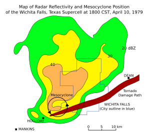
On 6 May 2009, a well-defined hook echo was noticed on local South African radars, along with satellite imagery this supported the presence of a strong supercell storm. Reports from the area indicated heavy rains, winds and large hail.

On October 2, 2011, two devastating tornadoes tore through two separate parts of South Africa on the same day, hours apart from each other. The first, classified as an EF2 hit Meqheleng, the informal settlement outside Ficksburg, Free State which devastated shacks and homes, uprooted trees, and killed one small child. The second, which hit the informal settlement of Duduza, Nigel in the Gauteng province, also classified as EF2 hit hours apart from the one that struck Ficksburg. This tornado completely devastated parts of the informal settlement and killed two children, destroying shacks and RDP homes.

Copper in biology

From Wikipedia, the free encyclopedia https://en.wikipedia.org/wiki/Cop...