| Amazon River |
| Apurímac, Ene, Tambo, Ucayali, Amazonas, Solimões |
Sunset on the Amazon at Leticia, Colombia |
| Countries |
Brazil, Colombia, Peru |
|
| Tributaries |
| - left |
Marañón, Japurá/Caquetá, Rio Negro/Guainía, Putumayo |
| - right |
Ucayali, Purús, Madeira, Tapajós, Xingu |
| City |
Iquitos (Peru); Leticia (Colombia);
Tabatinga (Brazil); Tefé (Brazil);
Itacoatiara (Brazil) Parintins (Brazil);
Óbidos (Brazil); Santarém (Brazil);
Almeirim (Brazil); Macapá (Brazil) |
|
|
| Source |
Andes |
| - location |
Nevado Mismi, Arequipa, Peru |
| - elevation |
5,170 m (16,962 ft) |
| - coordinates |
 15°31′5″S 71°45′55″W / 15.51806°S 71.76528°W / -15.51806; -71.76528 15°31′5″S 71°45′55″W / 15.51806°S 71.76528°W / -15.51806; -71.76528 |
| Mouth |
Atlantic Ocean |
| - elevation |
0 m (0 ft) |
| - coordinates |
0°42′28″N 50°5′22″W / 0.70778°N 50.08944°W / 0.70778; -50.08944 [1] |
|
| Length |
6,437 km (4,000 mi) [2] |
| Basin |
7,050,000 km2 (2,722,000 sq mi) [2] |
| Discharge |
|
| - average |
209,000 m3/s (7,381,000 cu ft/s) [3] |
|
Map showing the Amazon drainage basin with the Amazon River highlighted
|
The
Amazon River (
US // or
UK //;
Spanish and
Portuguese:
Amazonas) in
South America is the largest river by discharge of water in the world, averaging a
discharge of about 209,000 cubic meters per second (7,381,000 cu ft/s), greater than the next seven
largest independent rivers combined. The
Amazon basin is the largest
drainage basin in the world, about 7,050,000 square kilometres (2,720,000 sq mi), and accounts for approximately one-fifth of the world's total river flow. The portion of the river's drainage basin in
Brazil alone is larger than any other river's basin. The Amazon enters Brazil with only one-fifth of the flow it finally discharges into the
Atlantic Ocean, yet already has a greater flow at this point than the discharge of any other river.
[4][5]
In its upper stretches, above its confluence with the
Rio Negro, the Amazon is called
Solimões in Brazil; however, in
Peru,
Colombia and
Ecuador, as well as the rest of the
Spanish-speaking world, the river is generally called the Amazon downstream from the
confluence of the
Marañón and
Ucayali rivers in Peru. The Ucayali-
Apurímac river system is considered the main source of the Amazon, with its main
headstream being the
Carhuasanta glacial stream flowing off the
Nevado Mismi mountain.
The width of the Amazon is between 1.6 and 10 kilometres (1.0 and 6.2 mi) at low stage but expands during the
wet season to 48 kilometres (30 mi) or more. The river enters the Atlantic Ocean in a broad
estuary about 240 kilometres (150 mi) wide. The mouth of the
main stem is 80 kilometres (50 mi).
[6] Because of its vast dimensions, it is sometimes called "The River Sea".
The total volume of water discharging from the Amazon river in a year is about 6,591 cubic kilometres.
The largest city along the Amazon River is Manaus. Located in Brazil it is home to over 1.7 million people.
[7]
§Drainage area
The Amazon basin, the largest in the world, covers about 40% of South America, an area of approximately 7,050,000 square kilometres (2,720,000 sq mi). It drains from west to east, from
Iquitos in Peru, across Brazil to the Atlantic. It gathers its waters from
5 degrees north latitude to
20 degrees south latitude. Its most remote sources are found on the inter-
Andean plateau, just a short distance from the
Pacific Ocean. The locals often refer to it as "El Jefe Negro", referring to an ancient god of fertility.
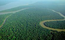
The Amazon River and its tributaries are characterized by extensive forested areas that become flooded every rainy season. Every year the river rises more than 9 metres (30 ft), flooding the surrounding forests, known as
várzea ("flooded forests"). The Amazon's flooded forests are the most extensive example of this habitat type in the world.
[8] In an average
dry season, 110,000 square kilometres (42,000 sq mi) of land are water-covered, while in the
wet season, the flooded area of the Amazon basin rises to 350,000 square kilometres (140,000 sq mi).
[9]
The quantity of water released by the Amazon to the Atlantic Ocean is enormous: up to 300,000 cubic metres per second (11,000,000 cu ft/s) in the rainy season, with an average of 209,000 cubic metres per second (7,400,000 cu ft/s) from 1973 to 1990.
[10] The Amazon is responsible for about 20% of the Earth's
fresh water entering the ocean.
[8] The river pushes a vast plume of fresh water into the ocean. The plume is about 400 kilometres (250 mi) long and between 100 and 200 kilometres (62 and 124 mi) wide. The fresh water, being lighter, flows on top of the seawater, diluting the
salinity and altering the color of the ocean surface over an area up to 1,000,000 square miles (2,600,000 km
2) in extent. For centuries ships have reported fresh water near the Amazon's mouth yet well out of sight of land in what otherwise seemed to be the open ocean.
[5]
The Atlantic has sufficient wave and tidal energy to carry most of the Amazon's
sediments out to sea, thus the Amazon does not form a true delta. The great deltas of the world are all in relatively protected bodies of water, while the Amazon empties directly into the turbulent Atlantic.
[11]
There is a natural water union between the Amazon and the
Orinoco basins, the so-called
Casiquiare canal. The Casiquiare is a river
distributary of the upper Orinoco, which flows southward into the Rio Negro, which in turn flows into the Amazon. The Casiquiare is the largest river on earth that links two major river systems, a so-called
bifurcation.
§Origins
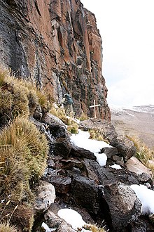
The Amazon originates from the Apacheta cliff in
Arequipa at the
Nevado Mismi, marked only by a wooden cross.
The Amazon river has a series of major river systems in
Colombia,
Ecuador and
Peru, some of which flow into the
Marañón and Ucayali, others directly into the Amazon proper. Among others, these include the following rivers:
Putumayo,
Caquetá,
Vaupés,
Guainía,
Morona,
Pastaza, Nucuray, Urituyacu,
Chambira,
Tigre,
Nanay,
Napo, and
Huallaga.
The most distant source of the Amazon was established in 1996,
[12] 2001,
[13] 2007,
[14] and 2008,
[15] as a glacial stream on a snowcapped 5,597 m (18,363 ft) peak called
Nevado Mismi in the Peruvian
Andes, roughly 160 km (99 mi) west of
Lake Titicaca and 700 km (430 mi) southeast of
Lima. The waters from Nevado Mismi flow into the Quebradas
Carhuasanta and Apacheta, which flow into the
Río Apurímac which is a tributary of the Ucayali which later joins the Marañón to form the Amazon proper. While the Ucayali–Marañón confluence is the point at which most geographers place the beginning of the Amazon proper, in Brazil the river is known at this point as the
Solimões das Águas. Further downriver from that confluence the darkly colored waters of the Rio Negro meet the sandy colored
Rio Solimões, and for over 6 km (4 mi) these waters run side by side without mixing.
After the confluence of Apurímac and Ucayali, the river leaves Andean terrain and is surrounded by
floodplain. From this point to the Marañón, some 1,600 km (990 mi), the forested banks are just out of water and are inundated long before the river attains its maximum flood stage. The low river banks are interrupted by only a few hills, and the river enters the enormous
Amazon rainforest.
The river systems and flood plains in Brazil, Peru, Ecuador, Colombia and Venezuela, whose waters drain into the
Solimões and its tributaries, are called the "Upper Amazon". The Amazon River proper runs mostly through Brazil and Peru. It is part of the border between Colombia and Perú, and it has tributaries reaching into Venezuela, Colombia, Ecuador, and Bolivia.
§Flooding

A
NASA satellite image of a flooded portion of the river
Not all of the Amazon's tributaries flood at the same time of the year. Many branches begin flooding in November and may continue to rise until June. The rise of the Rio Negro starts in February or March and begins to recede in June. The Madeira River rises and falls two months earlier than most of the rest of the Amazon.
The depth of the Amazon between
Manacapuru and
Óbidos has been calculated as between 20 to 26 metres (66 to 85 ft). At Manacapuru the Amazon's water level is only about 24 metres (79 ft) above
mean sea level. More than half of the water in the Amazon downstream of Manacapuru is below sea level.
[16] In its lowermost section the Amazon's depth averages 20 to 50 metres (66 to 164 ft), in some places as much as 100 metres (330 ft).
[17]
The main river is navigable for large ocean steamers to
Manaus, 1,500 kilometres (930 mi) upriver from the mouth. Smaller ocean vessels of 3,000 tons or 9,000 tons
[6] and 5.5 metres (18 ft)
draft can reach as far as
Iquitos, Peru, 3,600 kilometres (2,200 mi) from the sea. Smaller riverboats can reach 780 kilometres (480 mi) higher as far as Achual Point. Beyond that, small boats frequently ascend to the
Pongo de Manseriche, just above Achual Point.
Annual flooding is caused by tidal waves called "pororoca". The waves occur in late winter at high tide, when the
Atlantic Ocean overlaps into the river. The resulting waves can be up to 4 meters high and travel 13 kilometers inland.
[18]
§Geography
At some points the river divides into
anabranches, or multiple channels, often very long, with inland and lateral
channels, all connected by a complicated system of natural canals, cutting the low, flat
igapó lands, which are never more than 5 metres (16 ft) above low river, into many islands.
From the town of Canaria at the great bend of the Amazon to the Negro, vast areas of land are submerged at high water, above which only the upper part of the trees of the sombre forests appear. Near the mouth of the Rio Negro to Serpa, nearly opposite the river Madeira, the banks of the Amazon are low, until approaching Manaus, they rise to become rolling hills. At Óbidos, a bluff 17 m (56 ft) above the river is backed by low hills. The lower Amazon seems to have once been a
gulf of the Atlantic Ocean, the waters of which washed the cliffs near Óbidos.
Only about ten percent of the Amazon's water enters downstream of Óbidos, very little of which is from the northern slope of the valley. The drainage area of the Amazon basin above Óbidos city is about 5,000,000 square kilometres (1,900,000 sq mi), and, below, only about 1,000,000 square kilometres (390,000 sq mi) (around 20%), exclusive of the 1,400,000 square kilometres (540,000 sq mi) of the Tocantins basin. The
Tocantins River enters the southern portion of the Amazon delta.
In the lower reaches of the river, the north bank consists of a series of steep, table-topped hills extending for about 240 kilometres (150 mi) from opposite the mouth of the Xingu as far as
Monte Alegre. These hills are cut down to a kind of
terrace which lies between them and the river.
On the south bank, above the Xingu, a line of low bluffs bordering the floodplain extends nearly to
Santarém in a series of gentle curves before they bend to the southwest, and, abutting upon the lower Tapajós, merge into the bluffs which form the terrace margin of the Tapajós river valley.
§Mouth

A satellite image of the mouth of the Amazon River, looking south
The definition of where exactly the mouth of the Amazon is located, and how wide it is, is a matter of dispute, because of the area's peculiar geography. The Pará and the Amazon are connected by a series of river channels called
furos near the town of
Breves; between them lies
Marajó, the world's largest combined river/sea island.
If the Pará river and the Marajó island ocean frontage are included, the Amazon
estuary is some 325 kilometres (202 mi) wide.
[9] In this case, the width of the mouth of the river is usually measured from Cabo Norte, the cape located straight east of
Pracuúba in the Brazilian state of
Amapá, to Ponta da Tijoca near the town of
Curuçá, in the state of
Pará.
A more conservative measurement excluding the Pará river estuary, from the mouth of the
Araguari River to Ponta do Navio on the northern coast of Marajó, would still give the mouth of the Amazon a width of over 180 kilometres (110 mi). If only the river's main channel is considered, between the islands of Curuá (state of Amapá) and Jurupari (state of Pará), the width falls to about 15 kilometres (9.3 mi).
§Fauna
More than one-third of all known species in the world live in the
Amazon rainforest,
[19] a giant tropical forest and river basin with an area that stretches more than 5,400,000 square kilometres (2,100,000 sq mi). It is the richest tropical forest in the world in terms of
biodiversity. There are over 3,000 species of fish currently recognized in the Amazon basin, with more being discovered every year.
[20] In addition to the thousands of species of fish, the river supports crabs, algae, and turtles.
§Mammals
Along with the Orinoco, the Amazon is one of the main habitats of the
boto, also known as the
Amazon river dolphin (
Inia geoffrensis). It is the largest species of
river dolphin, and it can grow to lengths of up to 2.6 metres (8 ft 6 in). The color of its skin changes with age. It varies from gray when it is young, to pink and white as it matures. The dolphins use
echolocation to navigate and hunt in the river's tricky depths.
[21] The
boto is the subject of a legend in Brazil about a
dolphin that turns into a man and seduces maidens by the riverside. The
tucuxi (
Sotalia fluviatilis), also a dolphin species, is found both in the rivers of the Amazon basin and in the coastal waters of South America. The
Amazonian manatee (
Trichechus inunguis), also known as "seacow," is found in the northern Amazon River Basin and its tributaries. It is a mammal and an herbivore. Its population is limited to fresh water habitats, and, unlike other manatees, it does not venture into salt water. It is classified as vulnerable by the
International Union for Conservation of Nature.
The Amazon and its tributaries are the main habitat of the
giant otter (
Pteronura brasiliensis). It is a member of the
weasel family and is the largest of its kind. Because of habitat destruction and hunting its population has dramatically decreased.
§Reptiles
The
anaconda is found in shallow waters in the Amazon basin. One of the world's largest species of snake, the anaconda spends most of its time in the water with just its nostrils above the surface. The
caiman, which is related to alligators and other crocodilians, also inhabits the Amazon as do varieties of turtles.
§Fish
The Amazonian fish fauna is the center of diversity for
Neotropical fishes, of which more than 5,600 species are currently known
[22] The
bull shark (
Carcharhinus leucas) has been reported 4,000 kilometres (2,500 mi) up the Amazon River at
Iquitos in Peru. The
arapaima, known in Brazil as the
pirarucu (
Arapaima gigas), is a South American tropical
freshwater fish. It is one of the largest freshwater fish in the world, reportedly with a maximum length of 3 metres (9.8 ft) and weight up to 200 kilograms (440 lb).
[23] Another Amazonian freshwater fish is the
arowana (or
aruanã in Portuguese), such as the
silver arowana (
Osteoglossum bicirrhosum), which is a predator and very similar to the arapaima but only reaches a length of 120 centimetres (47 in). Also present in large numbers is the notorious
piranha, an omnivorous fish which congregates in large schools and may attack livestock and even humans. There are approximately 30 to 60 species of piranha. However, only a few of its species are known to attack humans, most notably
Pygocentrus nattereri, the red-bellied piranha. The
candirú, native to the Amazon River, is a species of parasitic fresh water
catfish in the family
Trichomycteridae.
[24] The
electric eel (
Electrophorus electricus) and more than 100 species of electric fishes
Gymnotiformes inhabit the Amazon basin. River stingrays (
Potamotrygonidae) are also known.
§Microbiota
Freshwater microbes are generally not very well known, even less so for a pristine ecosystem like the Amazon. Recently,
metagenomics has provided answers to what kind of microbes inhabit the river.
[25] The most important microbes in the Amazon River are
Actinobacteria,
Alphaproteobacteria,
Betaproteobacteria,
Gammaproteobacteria and
Crenarchaeota.
§Geology
The Amazon River originated as a transcontinental river in the Miocene Epoch between 11.8 million and 11.3 million years ago and took its present shape approximately 2.4 million years ago.
The Amazon once flowed west as part of a proto-Amazon-Congo river system, from the interior of present day Africa when the continents were joined as western Gondwana. Fifteen million years ago, the Andes were formed by the collision of the South American plate with the Nazca plate. The rise of the Andes and the linkage of the Brazilian and Guyana bedrock shields, blocked the river and caused the Amazon to become a vast inland sea. Gradually this inland sea became a massive swampy, freshwater lake and the marine inhabitants adapted to life in freshwater. For example, over 20 species of stingray, most closely related to those found in the Pacific Ocean, can be found today in the freshwaters of the Amazon.
Ten to eleven million years ago, waters worked through the sandstone from the west and the Amazon began to flow eastward, leading to the emergence of the Amazon rainforest. During Ice Ages, sea levels dropped and the great Amazon lake rapidly drained and became a river, which would eventually become the world's largest, draining the most extensive expanse of rainforest on the planet.
[26]
§History
§Precolonial civilization
During what many
archaeologists call the
formative period, Amazonian societies were deeply involved in the emergence of South America's highland
agrarian systems, and possibly contributed directly to the social and religious fabric constitutive of the
Andean civilizational orders.
§Mounds of the Amazon
Early human settlements were typically based on low-lying hills or mounds.
Five types of archaeological mound have been noted in the Amazon region: shell refuse and artificial mounds, artificial earth platforms for entire villages, earth mounds and ridges for cultivation, causeways and canals, and figurative mounds, both geometric and biomorphic.[27]
Shell mounds were the earliest; they represent piles of human refuse and are mainly dated between 7500 and 4000 BP. They all represent pottery age cultures; no preceramic shell mounds have been documented so far by archaeologists.
Figurative mounds are the latest chronologically.
Artificial earth platforms for entire villages are the second type of mounds. They are best represented by the
Marajoara culture.
There is ample evidence for complex large-scale, pre-Columbian social formations, including
chiefdoms, in many areas of Amazonia (particularly the inter-fluvial regions) and even large towns and cities.
[28] For instance the pre-Columbian culture on the island of
Marajó may have developed
social stratification and supported a population of 100,000 people.
[29] The Native Americans of the Amazon rain forest may have used
Terra preta to make the land suitable for the large-scale agriculture needed to support large populations and complex social formations such as chiefdoms.
[29]
Many indigenous tribes engaged in constant warfare. James Stuart Olson wrote: "The
Munduruku expansion dislocated and displaced the
Kawahíb, breaking the tribe down into much smaller groups... [Munduruku] first came to the attention of Europeans in 1770 when they began a series of widespread attacks on Brazilian settlements along the Amazon River."
[30]
§European discovery
In March 1500, Spanish conquistador
Vicente Yáñez Pinzón was the first documented European to sail into the river.
[31][disputed – discuss] Pinzón called the river flow
Río Santa María del Mar Dulce, later shortened to
Mar Dulce (literally,
sweet sea, because of its fresh water pushing out into the ocean).
§Exploration
Gonzalo Pizarro set off in 1541 to explore east of
Quito into the South American interior in search of
El Dorado, the "city of gold" and
La Canela, the "valley of
cinnamon".
[32] He was accompanied by his second-in-command
Francisco de Orellana. After 170 km, the
Coca River joined the
Napo River (at a point now known as
Puerto Francisco de Orellana); the party stopped for a few weeks to build a boat just upriver from this confluence. They continued downriver through an uninhabited area, where they could not find food. Orellana offered and was ordered to follow the Napo River, then known as
Río de la Canela ("Cinnamon River") and return with food for the party. Based on intelligence received from a captive native chief named Delicola, they expected to find food within a few days downriver by ascending another river to the north.
Orellana took about 57 men, the boat, and some canoes and left Pizarro's party on December 26, 1541. However, Orellana apparently missed the confluence (probably with the
Aguarico) where he was to look for food. By the time he and his men reached another village many of them were sick from hunger and eating "noxious plants", and near death. Seven men died at that village. His men threatened to mutiny if he followed his orders and the expedition turned back to join Pizarro's larger party. He accepted to change the purpose of the expedition to discover new lands in the name of the King of Spain, and the men built a larger boat in which to navigate downstream. After a journey of 600 km down the Napo River they reached a further major confluence, at a point near modern
Iquitos, and then followed the upper Amazon, now known as the Solimões, for a further 1,200 km to its confluence with the Rio Negro (near modern
Manaus), which they reached on 3 June 1542. On the
Nhamunda River, a tributary of the Amazon downstream from Manaus, Orellana's party had a fierce battle with warriors who, they reported, were led by fierce female warriors who beat the men to death with clubs if they tried to retreat.
[citation needed] Orellana's men began referring to the women as
Amazons, a reference to the women of
Greek Mythology. The river was initially known as the
Marañón (the name by which the Peruvian part of the river is still known today) or
Rio de Orellana. It later became known as the
Rio Amazonas, the name by which it is still known in both Spanish and Portuguese.
Regarding the initial mission of finding cinnamon, Pizarro reported to the King that they had found cinnamon trees, but that they could not be profitably harvested. In fact, true cinnamon (
Cinnamomum verum) is not native to South America. Other related cinnamon-containing plants (of the family
Lauraceae) are fairly common in that part of the Amazon and Pizarro probably saw some of these. The expedition reached the mouth of the Amazon on 24 August 1542, demonstrating the practical navigability of the Great River.
In 1560, another Spanish
conquistador,
Lope de Aguirre, may have made the second descent of the Amazon. Historians are uncertain whether the river he descended was the Amazon or the Orinoco River, which runs more or less parallel to the Amazon further north.
Portuguese explorer
Pedro Teixeira was the first European to travel up the entire river. He arrived in Quito in 1637, and then returned via the same route.
[33]
From 1648 to 1652, Portuguese Brazilian
bandeirante António Raposo Tavares led an expedition from
São Paulo overland to the mouth of the Amazon, investigating many of its tributaries, including the Rio Negro, and covering a distance of more than 10,000 km (6,214 mi).
In what is currently Brazil, Ecuador, Bolivia, Colombia, Peru, and Venezuela, a number of
colonial and religious settlements were established along the banks of primary rivers and tributaries for the purpose of trade, slaving and evangelization among the indigenous peoples of the vast rain forest, such as the
Urarina. In the late 1600s, Spanish Jesuit Father
Samuel Fritz, apostle of the Omaguas, established some forty mission villages.
§Scientific exploration
Early scientific, zoological and botanical exploration of the Amazon River and basin occurred in the second half of 18th century through the first half of the 19th century.
§Post-colonial exploitation and settlement
The
Cabanagem revolt (1835-1840) was directed against the white ruling class. It is estimated that from 30 to 40% of the population of
Grão-Pará, estimated at 100,000 people, died.
[35]
The total population of the Brazilian portion of the Amazon basin in 1850 was perhaps 300,000, of whom about two-thirds comprised by Europeans and slaves, the slaves amounting to about 25,000. The Brazilian Amazon's principal commercial city, Pará (now Belém), had from 10,000 to 12,000 inhabitants, including slaves. The town of Manáos, now Manaus, at the mouth of the Rio Negro, had a population between 1,000 to 1,500. All the remaining villages, as far up as
Tabatinga, on the Brazilian frontier of Peru, were relatively small.
On 6 September 1850 Emperor
Pedro II of Brazil sanctioned a law authorizing steam navigation on the Amazon and gave the Viscount of Mauá (
Irineu Evangelista de Sousa) the task of putting it into effect. He organized the "Companhia de Navegação e Comércio do Amazonas" in Rio de Janeiro in 1852; in the following year it commenced operations with three small steamers, the
Monarch, the
Marajó and
Rio Negro.
At first, navigation was principally confined to the main river; and even in 1857 a modification of the government contract only obliged the company to a monthly service between Pará and Manaus, with steamers of 200 tons cargo capacity, a second line to make six round voyages a year between Manaus and Tabatinga, and a third, two trips a month between Pará and Cametá. This was the first step in opening up the vast interior.
The success of the venture called attention to the opportunities for economic exploitation of the Amazon, and a second company soon opened commerce on the Madeira, Purús and Negro; a third established a line between Pará and Manaus; and a fourth found it profitable to navigate some of the smaller streams. In that same period, the Amazonas Company was increasing its fleet. Meanwhile, private individuals were building and running small steam craft of their own on the main river as well as on many of its tributaries.
On 31 July 1867 the government of Brazil, constantly pressed by the maritime powers and by the countries encircling the
upper Amazon basin, especially Peru, decreed the opening of the Amazon to all countries, but they limited this to certain defined points: Tabatinga – on the Amazon; Cametá – on the Tocantins; Santarém – on the Tapajós; Borba – on the Madeira, and Manaus – on the Rio Negro. The Brazilian decree took effect on 7 September 1867.
Thanks in part to the
mercantile development associated with
steamboat navigation coupled with the internationally driven demand for
natural rubber, the Peruvian city of
Iquitos became a thriving, cosmopolitan center of commerce. Foreign companies settled in Iquitos, from whence they controlled the extraction of rubber. In 1851 Iquitos had a population of 200, and by 1900 its population reached 20,000. In the 1860s, approximately 3,000 tons of rubber was being exported annually, and by 1911 annual exports had grown to 44,000 tons, representing 9.3% of Peru's exports.
[36] During the
rubber boom it is estimated that diseases brought by immigrants such as
typhus or
malaria killed 40,000 native Amazonians.
[37]
The first direct foreign trade with Manaus was commenced around 1874. Local trade along the river was carried on by the English successors to the Amazonas Company—the Amazon Steam Navigation Company—as well as numerous small steamboats, belonging to companies and firms engaged in the rubber trade, navigating the Negro, Madeira, Purús and many other tributaries, such as the Marañón to ports as distant as
Nauta, Peru.
By the turn of the 20th century, the exports of the Amazon basin were
India-rubber,
cacao beans,
Brazil nuts and a few other products of minor importance, such as
pelts and exotic forest produce (
resins, barks, woven
hammocks, prized bird
feathers, live animals) and extracted goods such as
lumber and gold.
§20th-century development
For 350 years after the first European encounter of the Amazon by Pinzón, the Portuguese portion of the basin remained an untended former food gathering and planned agricultural landscape occupied by the
indigenous peoples who survived the arrival of European diseases.
Four centuries after the European discovery of the Amazon river, the total cultivated area in its basin was probably less than 65 square kilometres (25 sq mi), excluding the limited and crudely cultivated areas among the mountains at its extreme headwaters. This situation changed dramatically during the 20th century.
Wary of foreign exploitation of the nation's resources, Brazilian governments in the 1940s set out to develop the interior, away from the seaboard where foreigners owned large tracts of land. The original architect of this expansion was President
Getúlio Vargas, with the demand for rubber from the Allied forces in World War II providing funding for the drive.
In 1960, the construction of the new capital city of
Brasília in the interior also contributed to the opening up of the Amazon basin. A large-scale colonization program saw families from northeastern Brazil relocated to the forests, encouraged by promises of cheap land. Many settlements grew along the road from Brasília to Belém, but rainforest soil proved difficult to cultivate.
Still, long-term development plans continued. Roads were cut through the forests, and in 1970, the work on the
Trans-Amazonian Highway (
Transamazônica) network began. The network's three pioneering highways were completed within ten years but never fulfilled their promise. Large portions of the Trans-Amazonian and its accessory roads, such as
BR-319 (Manaus-
Porto Velho), are derelict and impassable in the rainy season. Small towns and villages are scattered across the forest, and because its vegetation is so dense, some remote areas are still unexplored.
With a population of 1.9 million people in 2014, Manaus is the largest city on the Amazon. Manaus alone makes up approximately 50% of the population of the Brazilian state of Amazonas, which is the largest state. The racial makeup of the city is 64%
Pardo (Mulatto and mestizo) and 32%
White.
[38]
§Dispute regarding length
While debate as to whether the Amazon or the
Nile is the world's longest river has gone on for many years, the historic consensus of geographic authorities has been to regard the Amazon as the second longest river in the world, with the Nile being the longest. However, the Amazon has been measured by different geographers as being anywhere between 6,259 and 6,800 kilometres (3,889 and 4,225 mi) long. It is often said to be "at least" 6,400 kilometres (4,000 mi) long.
[39] The Nile is reported to be anywhere from 5,499 to 6,690 kilometres (3,417 to 4,157 mi). Often it is said to be "about" 6,650 kilometres (4,130 mi) long.
[40] There are many factors that can affect these measurements.
A study by Brazilian scientists concluded that the Amazon is actually longer than the Nile. Using
Nevado Mismi, which in 2001 was labeled by the
National Geographic Society as the Amazon's source, these scientists made new calculations of the Amazon's length. They calculated the Amazon's length as 6,992 kilometres (4,345 mi). Using the same techniques they calculated the length of the Nile as 6,853 kilometres (4,258 mi), which is longer than previous estimates but still shorter than the Amazon. They made it possible by measuring the Amazon downstream to the beginning of the tidal estuary of
Canal do Sul and then, after a sharp turn back, following tidal canals surrounding the isle of Marajó and finally including the marine waters of the
Río Pará bay in its entire length.
[15][41] Guido Gelli, director of science at the
Brazilian Institute of Geography and Statistics (IBGE), told the Brazilian TV network
Globo in June 2007 that it could be considered as a fact that the Amazon was the longest river in the world. However, other geographers have had access to the same data since 2001, and a consensus has yet to emerge to support the claims of these Brazilian scientists. The length of both the Amazon and the Nile remains open to interpretation and continued debate.
[39]
§Underground "river"
Scientists have discovered the longest underground "river" (actually a
saline water aquifer) in the world, in Brazil. Water in the aquifer flows a distance of 6,000 kilometres (3,700 mi) at a depth of nearly 4,000 metres (13,000 ft). It flows from the Andean foothills to the Atlantic coast in a nearly west-to-east direction like the Amazon River. The discovery was made public in August 2011
[42] meeting of the Brazilian Geophysical Society in
Rio de Janeiro. The "river", named
Hamza after the discoverer, an Indian-born scientist
Valiya Hamza who is working with the National Observatory at Rio, makes it the first and geologically unusual instance of a twin-river system flowing at different levels of the earth's crust in Brazil. A combination of
seismic data and anomalous temperature variation with depth measured in 241 inactive oil wells helped locate the aquifer. Except for the flow direction, the Amazon and the Hamza have very different characteristics. The most obvious ones are their width and flow speed. While the Amazon is 1 kilometre (0.62 mi) to 100 kilometres (62 mi) wide, the Hamza is 200 kilometres (120 mi) to 400 kilometres (250 mi) in width. But the flow speed is 5 metres per second (16 ft/s) in the Amazon and less than 1 millimetre per second (0.039 in/s) speed in the Hamza.
[42]
Several geological factors have played a vital role in the formation and existence of these subterranean water bodies. The large deep aquifer formed when the plate carrying the Pacific Ocean bottom gets dragged and ends up under the continental plate.
[citation needed] Water at such depths would normally escape upwards but the unusual conditions that exist along the eastern Pacific Rim allow the moisture to remain intact. In the case of the Hamza, the
porous and
permeable sedimentary rocks behave as conduits for the water to sink to greater depths. East-west trending
faults and the
karst topography present along the northern border of the Amazon basin may have some role in supplying water to the "river". If the impermeable rocks stop the vertical flow, the west to east gradient of the topography directs it to flow towards the Atlantic Ocean.
Unlike the Hamza, the 153 km-long underground river in Mexico's
Yucatán Peninsula[citation needed] and the 8.2 km-long
Cabayugan River in the
Puerto Princesa Subterranean River National Park in the
Philippines have come into being thanks to the
karst topography. Water in these places has dissolved the carbonate rock to form extensive underground river systems.
§Major tributaries
The Amazon has over 1,100
tributaries, 17 of which are over 1,500 kilometres (930 mi) long.
[43] Some of the more notable ones are:
Solimões, the section of the upper Amazon River
§List by length
- 6,259.2 km (3,889.3 mi) to 6,712 km (4,171 mi) – Amazon, South America[44]
- 3,250 km (2,020 mi) – Madeira, Bolivia/Brazil[45]
- 3,211 km (1,995 mi) – Purús, Peru/Brazil[46]
- 2,820 km (1,750 mi) – Yapura, Colombia/Brazil[47]
- 2,639 km (1,640 mi) – Tocantins, Brazil[48]

An aerial view of an Amazon tributary
- 2,627 km (1,632 mi) – Araguaia, Brazil (tributary of Tocantins)[49]
- 2,400 km (1,500 mi) – Juruá, Peru/Brazil[50]
- 2,250 km (1,400 mi) – Rio Negro, Brazil/Venezuela/Colombia[51]
- 1,992 km (1,238 mi) – Tapajós, Brazil[52]
- 1,979 km (1,230 mi) – Xingu, Brazil[53]
- 1,900 km (1,200 mi) – Ucayali River, Peru[54]
- 1,749 km (1,087 mi) – Guaporé, Brazil/Bolivia (tributary of Madeira)[55]
- 1,575 km (979 mi) – Içá (Putumayo), South America
- 1,415 km (879 mi) – Marañón, Peru
- 1,370 km (850 mi) – Teles Pires, Brazil (tributary of Tapajós)
- 1,300 km (810 mi) – Iriri, Brazil (tributary of Xingu)
- 1,240 km (770 mi) – Juruena, Brazil (tributary of Tapajós)
- 1,130 km (700 mi) – Madre de Dios, Peru/Bolivia (tributary of Madeira)
- 1,100 km (680 mi) – Huallaga, Peru (tributary of Marañón)


 Oceanic ridge and deep sea vent chemistry
 Age of oceanic crust. The red is most recent, and blue is the oldest.
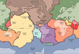 Plates in the crust of the earth, according to the plate tectonics theory
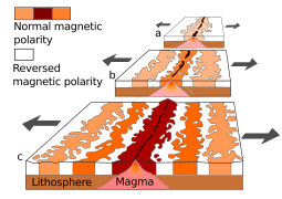 Seafloor magnetic striping
 A demonstration of magnetic striping


.jpg)