Search This Blog

Thursday, April 4, 2019

Ocean

From Wikipedia, the free encyclopedia

Clouds over the Atlantic Ocean
 
An ocean is a body of water that composes much of a planet's hydrosphere. On Earth, an ocean is one of the major conventional divisions of the World Ocean. These are, in descending order by area, the Pacific, Atlantic, Indian, Southern (Antarctic), and Arctic Oceans. The word "ocean" is often used interchangeably with "sea" in American English. Strictly speaking, a sea is a body of water (generally a division of the world ocean) partly or fully enclosed by land, though "the sea" refers also to the oceans. 

Saline water covers approximately 361,000,000 km2 (139,000,000 sq mi) and is customarily divided into several principal oceans and smaller seas, with the ocean covering approximately 71% of Earth's surface and 90% of the Earth's biosphere. The ocean contains 97% of Earth's water, and oceanographers have stated that less than 5% of the World Ocean has been explored. The total volume is approximately 1.35 billion cubic kilometers (320 million cu mi) with an average depth of nearly 3,700 meters (12,100 ft).

As the world ocean is the principal component of Earth's hydrosphere, it is integral to life, forms part of the carbon cycle, and influences climate and weather patterns. The World Ocean is the habitat of 230,000 known species, but because much of it is unexplored, the number of species that exist in the ocean is much larger, possibly over two million. The origin of Earth's oceans is unknown; oceans are thought to have formed in the Hadean eon and may have been the impetus for the emergence of life

Extraterrestrial oceans may be composed of water or other elements and compounds. The only confirmed large stable bodies of extraterrestrial surface liquids are the lakes of Titan, although there is evidence for the existence of oceans elsewhere in the Solar System. Early in their geologic histories, Mars and Venus are theorized to have had large water oceans. The Mars ocean hypothesis suggests that nearly a third of the surface of Mars was once covered by water, and a runaway greenhouse effect may have boiled away the global ocean of Venus. Compounds such as salts and ammonia dissolved in water lower its freezing point so that water might exist in large quantities in extraterrestrial environments as brine or convecting ice. Unconfirmed oceans are speculated beneath the surface of many dwarf planets and natural satellites; notably, the ocean of Europa is estimated to have over twice the water volume of Earth. The Solar System's giant planets are also thought to have liquid atmospheric layers of yet to be confirmed compositions. Oceans may also exist on exoplanets and exomoons, including surface oceans of liquid water within a circumstellar habitable zone. Ocean planets are a hypothetical type of planet with a surface completely covered with liquid.

Etymology

The word ocean comes from the figure in classical antiquity, Oceanus (/ˈsənəs/; Greek: Ὠκεανός Ōkeanós, pronounced [ɔːkeanós]), the elder of the Titans in classical Greek mythology, believed by the ancient Greeks and Romans to be the divine personification of the sea, an enormous river encircling the world. 

The concept of Ōkeanós has an Indo-European connection. Greek Ōkeanós has been compared to the Vedic epithet ā-śáyāna-, predicated of the dragon Vṛtra-, who captured the cows/rivers. Related to this notion, the Okeanos is represented with a dragon-tail on some early Greek vases.

Earth's global ocean

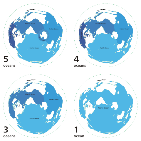
Rotating series of maps showing alternate divisions of the oceans
Various ways to divide the World Ocean

Oceanic divisions

1. Epipelagic zone: surface – 200 meters deep 2. Mesopelagic zone: 200 m – 1000 m 3. Bathypelagic zone: 1000 m – 4000 m 4. Abyssopelagic zone: 4000 m – 6000 m 5. Hadal zone (the trenches): 6000 m to the bottom of the ocean
 
Though generally described as several separate oceans, the global, interconnected body of salt water is sometimes referred to as the World Ocean or global ocean. The concept of a continuous body of water with relatively free interchange among its parts is of fundamental importance to oceanography.

The major oceanic divisions – listed below in descending order of area and volume – are defined in part by the continents, various archipelagos, and other criteria.

# Ocean Location Area
(km2)
(%)
Volume
(km3)
(%)
Avg. depth
(m)
Coastline
(km)
1 Pacific Ocean Separates Asia and Oceania from the Americas 168,723,000
46.6
669,880,000
50.1
3,970 135,663
2 Atlantic Ocean Separates the Americas from Europe and Africa 85,133,000
23.5
310,410,900
23.3
3,646 111,866
3 Indian Ocean Washes upon southern Asia and separates Africa and Australia 70,560,000
19.5
264,000,000
19.8
3,741 66,526
4 Southern Ocean Sometimes considered an extension of the Pacific, Atlantic and Indian Oceans, which encircles Antarctica 21,960,000
6.1
71,800,000
5.4
3,270 17,968
5 Arctic Ocean Sometimes considered a sea or estuary of the Atlantic, which covers much of the Arctic and washes upon northern North America and Eurasia 15,558,000
4.3
18,750,000
1.4
1,205 45,389
Total – World Ocean 361,900,000
100
1.335×10⁹
100
3,688 377,412

Seas and Bays
Sea Location Area (sq. km)
#
Arabian Sea Between the Arabian peninsula and the Indian subcontinent 3,862,000 1
Bay of Bengal Between the Indian subcontinent and the malaysia peninsula 2,173,000 2
NB: Volume, area, and average depth figures include NOAA ETOPO1 figures for marginal South China Sea.
Sources: Encyclopedia of Earth, International Hydrographic Organization, Regional Oceanography: an Introduction (Tomczak, 2005), Encyclopædia Britannica, and the International Telecommunication Union.
Oceans are fringed by smaller, adjoining bodies of water such as seas, gulfs, bays, bights, and straits.

Global system

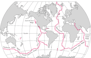
World Distribution of Mid-Oceanic Ridges; USGS
 
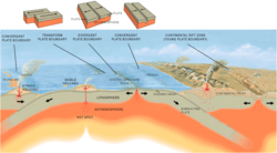
Three main types of plate boundaries.
 
The mid-ocean ridges of the world are connected and form a single global mid-oceanic ridge system that is part of every ocean and the longest mountain range in the world. The continuous mountain range is 65,000 km (40,000 mi) long (several times longer than the Andes, the longest continental mountain range).

Physical properties

The total mass of the hydrosphere is about 1.4 quintillion metric tons (1.4×10¹⁸ long tons or 1.5×10¹⁸ short tons), which is about 0.023% of Earth's total mass. Less than 3% is freshwater; the rest is saltwater, almost all of which is in the ocean. The area of the World Ocean is about 361.9 million square kilometers (139.7 million square miles), which covers about 70.9% of Earth's surface, and its volume is approximately 1.335 billion cubic kilometers (320.3 million cubic miles). This can be thought of as a cube of water with an edge length of 1,101 kilometers (684 mi). Its average depth is about 3,688 meters (12,100 ft), and its maximum depth is 10,994 meters (6.831 mi) at the Mariana Trench. Nearly half of the world's marine waters are over 3,000 meters (9,800 ft) deep. The vast expanses of deep ocean (anything below 200 meters or 660 feet) cover about 66% of Earth's surface. This does not include seas not connected to the World Ocean, such as the Caspian Sea

The bluish ocean color is a composite of several contributing agents. Prominent contributors include dissolved organic matter and chlorophyll. Mariners and other seafarers have reported that the ocean often emits a visible glow which extends for miles at night. In 2005, scientists announced that for the first time, they had obtained photographic evidence of this glow. It is most likely caused by bioluminescence.

Oceanic zones

Drawing showing divisions according to depth and distance from shore
The major oceanic zones, based on depth and biophysical conditions
 
Oceanographers divide the ocean into different vertical zones defined by physical and biological conditions. The pelagic zone includes all open ocean regions, and can be divided into further regions categorized by depth and light abundance. The photic zone includes the oceans from the surface to a depth of 200 m; it is the region where photosynthesis can occur and is, therefore, the most biodiverse. Because plants require photosynthesis, life found deeper than the photic zone must either rely on material sinking from above (see marine snow) or find another energy source. Hydrothermal vents are the primary source of energy in what is known as the aphotic zone (depths exceeding 200 m). The pelagic part of the photic zone is known as the epipelagic

The pelagic part of the aphotic zone can be further divided into vertical regions according to temperature. The mesopelagic is the uppermost region. Its lowermost boundary is at a thermocline of 12 °C (54 °F), which, in the tropics generally lies at 700–1,000 meters (2,300–3,300 ft). Next is the bathypelagic lying between 10 and 4 °C (50 and 39 °F), typically between 700–1,000 meters (2,300–3,300 ft) and 2,000–4,000 meters (6,600–13,100 ft), lying along the top of the abyssal plain is the abyssopelagic, whose lower boundary lies at about 6,000 meters (20,000 ft). The last zone includes the deep oceanic trench, and is known as the hadalpelagic. This lies between 6,000–11,000 meters (20,000–36,000 ft) and is the deepest oceanic zone. 

The benthic zones are aphotic and correspond to the three deepest zones of the deep-sea. The bathyal zone covers the continental slope down to about 4,000 meters (13,000 ft). The abyssal zone covers the abyssal plains between 4,000 and 6,000 m. Lastly, the hadal zone corresponds to the hadalpelagic zone, which is found in oceanic trenches. 

The pelagic zone can be further subdivided into two subregions: the neritic zone and the oceanic zone. The neritic zone encompasses the water mass directly above the continental shelves whereas the oceanic zone includes all the completely open water. 

In contrast, the littoral zone covers the region between low and high tide and represents the transitional area between marine and terrestrial conditions. It is also known as the intertidal zone because it is the area where tide level affects the conditions of the region.

If a zone undergoes dramatic changes in temperature with depth, it contains a thermocline. The tropical thermocline is typically deeper than the thermocline at higher latitudes. Polar waters, which receive relatively little solar energy, are not stratified by temperature and generally lack a thermocline because surface water at polar latitudes are nearly as cold as water at greater depths. Below the thermocline, water is very cold, ranging from −1 °C to 3 °C. Because this deep and cold layer contains the bulk of ocean water, the average temperature of the world ocean is 3.9 °C.[citation needed] If a zone undergoes dramatic changes in salinity with depth, it contains a halocline. If a zone undergoes a strong, vertical chemistry gradient with depth, it contains a chemocline

The halocline often coincides with the thermocline, and the combination produces a pronounced pycnocline.

Exploration

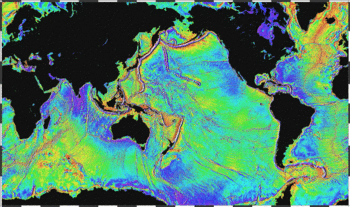
False color photo
Map of large underwater features (1995, NOAA)
 
The deepest point in the ocean is the Mariana Trench, located in the Pacific Ocean near the Northern Mariana Islands. Its maximum depth has been estimated to be 10,971 meters (35,994 ft) (plus or minus 11 meters; see the Mariana Trench article for discussion of the various estimates of the maximum depth.) The British naval vessel Challenger II surveyed the trench in 1951 and named the deepest part of the trench the "Challenger Deep". In 1960, the Trieste successfully reached the bottom of the trench, manned by a crew of two men.

Oceanic maritime currents

Oceanic surface currents (U.S. Army, 1943).
 
Amphidromic points showing the direction of tides per incrementation periods along with resonating directions of wavelength movements.
 
Oceanic maritime currents have different origins. Tidal currents are in phase with the tide, hence are quasiperiodic; they may form various knots in certain places, most notably around headlands. Non-periodic currents have for origin the waves, wind and different densities. 

The wind and waves create surface currents (designated as “drift currents”). These currents can decompose in one quasi-permanent current (which varies within the hourly scale) and one movement of Stokes drift under the effect of rapid waves movement (at the echelon of a couple of seconds).).[36] The quasi-permanent current is accelerated by the breaking of waves, and in a lesser governing effect, by the friction of the wind on the surface.

This acceleration of the current takes place in the direction of waves and dominant wind. Accordingly, when the sea depth increases, the rotation of the earth changes the direction of currents in proportion with the increase of depth, while friction lowers their speed. At a certain sea depth, the current changes direction and is seen inverted in the opposite direction with current speed becoming null: known as the Ekman spiral. The influence of these currents is mainly experienced at the mixed layer of the ocean surface, often from 400 to 800 meters of maximum depth. These currents can considerably alter, change and are dependent on the various yearly seasons. If the mixed layer is less thick (10 to 20 meters), the quasi-permanent current at the surface adopts an extreme oblique direction in relation to the direction of the wind, becoming virtually homogeneous, until the Thermocline.

In the deep however, maritime currents are caused by the temperature gradients and the salinity between water density masses. 

In littoral zones, breaking waves are so intense and the depth measurement so low, that maritime currents reach often 1 to 2 knots.

Climate

World map with colored, directed lines showing how water moves through the oceans. Cold deep water rises and warms in the central Pacific and in the Indian, whereas warm water sinks and cools near Greenland in the North Atlantic and near Antarctica in the South Atlantic.
A map of the global thermohaline circulation; blue represent deep-water currents, whereas red represent surface currents
 
Ocean currents greatly affect Earth's climate by transferring heat from the tropics to the polar regions. Transferring warm or cold air and precipitation to coastal regions, winds may carry them inland. Surface heat and freshwater fluxes create global density gradients that drive the thermohaline circulation part of large-scale ocean circulation. It plays an important role in supplying heat to the polar regions, and thus in sea ice regulation. Changes in the thermohaline circulation are thought to have significant impacts on Earth's energy budget. In so far as the thermohaline circulation governs the rate at which deep waters reach the surface, it may also significantly influence atmospheric carbon dioxide concentrations. 

The Antarctic Circumpolar Current encircles that continent, influencing the area's climate and connecting currents in several oceans. 

One of the most dramatic forms of weather occurs over the oceans: tropical cyclones (also called "typhoons" and "hurricanes" depending upon where the system forms).

Biology

The ocean has a significant effect on the biosphere. Oceanic evaporation, as a phase of the water cycle, is the source of most rainfall, and ocean temperatures determine climate and wind patterns that affect life on land. Life within the ocean evolved 3 billion years prior to life on land. Both the depth and the distance from shore strongly influence the biodiversity of the plants and animals present in each region.

As it is thought that life evolved in the ocean, the diversity of life is immense, including:
In addition, many land animals have adapted to living a major part of their life on the oceans. For instance, seabirds are a diverse group of birds that have adapted to a life mainly on the oceans. They feed on marine animals and spend most of their lifetime on water, many only going on land for breeding. Other birds that have adapted to oceans as their living space are penguins, seagulls and pelicans. Seven species of turtles, the sea turtles, also spend most of their time in the oceans.

Gases

Characteristics of oceanic gases 
Gas Concentration of seawater, by mass (in parts per million), for the whole ocean % Dissolved gas, by volume, in seawater at the ocean surface
Carbon dioxide (CO2) 64 to 107 15%
Nitrogen (N2) 10 to 18 48%
Oxygen (O2) 0 to 13 36%

Solubility of oceanic gases (in mL/L) with temperature at salinity of 33‰ and atmospheric pressure
Temperature O2 CO2 N2
0 °C 8.14 8,700 14.47
10 °C 6.42 8,030 11.59
20 °C 5.26 7,350 9.65
30 °C 4.41 6,600 8.26

Surface

Generalized characteristics of ocean surface by latitude 
Characteristic Oceanic waters in polar regions Oceanic waters in temperate regions Oceanic waters in tropical regions
Precipitation vs. evaporation P > E P > E E > P
Sea surface temperature in winter −2 °C 5 to 20 °C 20 to 25 °C
Average salinity 28‰ to 32‰ 35‰ 35‰ to 37‰
Annual variation of air temperature ≤ 40ªC 10 °C < 5 °C
Annual variation of water temperature < 5ªC 10 °C < 5 °C

Mixing time

Mean oceanic residence time for various constituents 
Constituent Residence time (in years)
Iron (Fe) 200
Aluminum (Al) 600
Manganese (Mn) 1,300
Water (H2O) 4,100
Silicon (Si) 20,000
Carbonate (CO32−) 110,000
Calcium (Ca2+) 1,000,000
Sulfate (SO42−) 11,000,000
Potassium (K+) 12,000,000
Magnesium (Mg2+) 13,000,000
Sodium (Na+) 68,000,000
Chloride (Cl) 100,000,000

Salinity

A zone of rapid salinity increase with depth is called a halocline. The temperature of maximum density of seawater decreases as its salt content increases. Freezing temperature of water decreases with salinity, and boiling temperature of water increases with salinity. Typical seawater freezes at around −2 °C at atmospheric pressure. If precipitation exceeds evaporation, as is the case in polar and temperate regions, salinity will be lower. If evaporation exceeds precipitation, as is the case in tropical regions, salinity will be higher. Thus, oceanic waters in polar regions have lower salinity content than oceanic waters in temperate and tropical regions.

Salinity can be calculated using the chlorinity, which is a measure of the total mass of halogen ions (includes fluorine, chlorine, bromine, and iodine) in seawater. By international agreement, the following formula is used to determine salinity: 

Salinity (in ‰) = 1.80655 × Chlorinity (in ‰)

The average chlorinity is about 19.2‰, and, thus, the average salinity is around 34.7‰ 

Absorption of light

Absorption of light in different wavelengths by ocean 
Color: Wavelength (nm) Depth at which 99 percent of the wavelength is absorbed (in meters) Percent absorbed in 1 meter of water
Ultraviolet (UV): 310 31 14.0
Violet (V): 400 107 4.2
Blue (B): 475 254 1.8
Green (G): 525 113 4.0
Yellow (Y): 575 51 8.7
Orange (O): 600 25 16.7
Red (R): 725 4 71.0
Infrared (IR): 800 3 82.0

Economic value

Many of the world's goods are moved by ship between the world's seaports. Oceans are also the major supply source for the fishing industry. Some of the major harvests are shrimp, fish, crabs, and lobster.

Waves and swell

The motions of the ocean surface, known as undulations or waves, are the partial and alternate rising and falling of the ocean surface. The series of mechanical waves that propagate along the interface between water and air is called swell.

Extraterrestrial oceans

Artist's conception of subsurface ocean of Enceladus confirmed April 3, 2014.
 
Two models for the composition of Europa predict a large subsurface ocean of liquid water. Similar models have been proposed for other celestial bodies in the Solar System.
 
Although Earth is the only known planet with large stable bodies of liquid water on its surface and the only one in the Solar System, other celestial bodies are thought to have large oceans.

Planets

The gas giants, Jupiter and Saturn, are thought to lack surfaces and instead have a stratum of liquid hydrogen; however their planetary geology is not well understood. The possibility of the ice giants Uranus and Neptune having hot, highly compressed, supercritical water under their thick atmospheres has been hypothesised. Although their composition is still not fully understood, a 2006 study by Wiktorowicz and Ingersall ruled out the possibility of such a water "ocean" existing on Neptune, though some studies have suggested that exotic oceans of liquid diamond are possible.

The Mars ocean hypothesis suggests that nearly a third of the surface of Mars was once covered by water, though the water on Mars is no longer oceanic (much of it residing in the ice caps). The possibility continues to be studied along with reasons for their apparent disappearance. Astronomers think that Venus had liquid water and perhaps oceans in its very early history. If they existed, all later vanished via resurfacing.

Natural satellites

A global layer of liquid water thick enough to decouple the crust from the mantle is thought to be present on the natural satellites Titan, Europa, Enceladus and, with less certainty, Callisto, Ganymede and Triton. A magma ocean is thought to be present on Io. Geysers have been found on Saturn's moon Enceladus, possibly originating from an ocean about 10 kilometers (6.2 mi) beneath the surface ice shell. Other icy moons may also have internal oceans, or may once have had internal oceans that have now frozen.

Large bodies of liquid hydrocarbons are thought to be present on the surface of Titan, although they are not large enough to be considered oceans and are sometimes referred to as lakes or seas. The Cassini–Huygens space mission initially discovered only what appeared to be dry lakebeds and empty river channels, suggesting that Titan had lost what surface liquids it might have had. Later flybys of Titan provided radar and infrared images that showed a series of hydrocarbon lakes in the colder polar regions. Titan is thought to have a subsurface liquid-water ocean under the ice in addition to the hydrocarbon mix that forms atop its outer crust.

Dwarf planets and trans-Neptunian objects

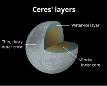
Diagram showing a possible internal structure of Ceres

Ceres appears to be differentiated into a rocky core and icy mantle and may harbour a liquid-water ocean under its surface.

Not enough is known of the larger trans-Neptunian objects to determine whether they are differentiated bodies capable of supporting oceans, although models of radioactive decay suggest that Pluto, Eris, Sedna, and Orcus have oceans beneath solid icy crusts approximately 100 to 180 km thick.

Extrasolar

Rendering of a hypothetical large extrasolar moon with surface liquid-water oceans
 
Some planets and natural satellites outside the Solar System are likely to have oceans, including possible water ocean planets similar to Earth in the habitable zone or "liquid-water belt". The detection of oceans, even through the spectroscopy method, however is likely extremely difficult and inconclusive. 

Theoretical models have been used to predict with high probability that GJ 1214 b, detected by transit, is composed of exotic form of ice VII, making up 75% of its mass, making it an ocean planet.

Other possible candidates are merely speculated based on their mass and position in the habitable zone include planet though little is actually known of their composition. Some scientists speculate Kepler-22b may be an "ocean-like" planet. Models have been proposed for Gliese 581 d that could include surface oceans. Gliese 436 b is speculated to have an ocean of "hot ice". Exomoons orbiting planets, particularly gas giants within their parent star's habitable zone may theoretically have surface oceans. 

Terrestrial planets will acquire water during their accretion, some of which will be buried in the magma ocean but most of it will go into a steam atmosphere, and when the atmosphere cools it will collapse on to the surface forming an ocean. There will also be outgassing of water from the mantle as the magma solidifies—this will happen even for planets with a low percentage of their mass composed of water, so "super-Earth exoplanets may be expected to commonly produce water oceans within tens to hundreds of millions of years of their last major accretionary impact."

Non-water surface liquids

Oceans, seas, lakes and other bodies of liquids can be composed of liquids other than water, for example the hydrocarbon lakes on Titan. The possibility of seas of nitrogen on Triton was also considered but ruled out. There is evidence that the icy surfaces of the moons Ganymede, Callisto, Europa, Titan and Enceladus are shells floating on oceans of very dense liquid water or water–ammonia. Earth is often called the ocean planet because it is 70% covered in water. Extrasolar terrestrial planets that are extremely close to their parent star will be tidally locked and so one half of the planet will be a magma ocean. It is also possible that terrestrial planets had magma oceans at some point during their formation as a result of giant impacts. Hot Neptunes close to their star could lose their atmospheres via hydrodynamic escape, leaving behind their cores with various liquids on the surface. Where there are suitable temperatures and pressures, volatile chemicals that might exist as liquids in abundant quantities on planets include ammonia, argon, carbon disulfide, ethane, hydrazine, hydrogen, hydrogen cyanide, hydrogen sulfide, methane, neon, nitrogen, nitric oxide, phosphine, silane, sulfuric acid, and water.

Supercritical fluids, although not liquids, do share various properties with liquids. Underneath the thick atmospheres of the planets Uranus and Neptune, it is expected that these planets are composed of oceans of hot high-density fluid mixtures of water, ammonia and other volatiles. The gaseous outer layers of Jupiter and Saturn transition smoothly into oceans of supercritical hydrogen. The atmosphere of Venus is 96.5% carbon dioxide, which is a supercritical fluid at its surface.

Geology of solar terrestrial planets

From Wikipedia, the free encyclopedia

The inner planets. From left to right: Mercury, Venus, Earth, Mars and terrestrial dwarf planet, Ceres (sizes to scale)

The geology of solar terrestrial planets mainly deals with the geological aspects of the four terrestrial planets of the Solar SystemMercury, Venus, Earth, and Mars – and one terrestrial dwarf planet: Ceres. Earth is the only terrestrial planet known to have an active hydrosphere.

Terrestrial planets are substantially different from the giant planets, which might not have solid surfaces and are composed mostly of some combination of hydrogen, helium, and water existing in various physical states. Terrestrial planets have a compact, rocky surfaces, and Venus, Earth, and Mars each also have an atmosphere. Their size, radius, and density are all similar.

Terrestrial planets have numerous similarities to plutoids (objects like Pluto), which also have a solid surface, but are primarily composed of icy materials. During the formation of the Solar System, there were probably many more (planetesimals), but they have all merged with or been destroyed by the four remaining worlds in the solar nebula.

The terrestrial planets all have roughly the same structure: a central metallic core, mostly iron, with a surrounding silicate mantle. The Moon is similar, but lacks a substantial iron core. Three of the four solar terrestrial planets (Venus, Earth, and Mars) have substantial atmospheres; all have impact craters and tectonic surface features such as rift valleys and volcanoes.

The term inner planet should not be confused with inferior planet, which refers to any planet that is closer to the Sun than the observer's planet is, but usually refers to Mercury and Venus.

Formation of solar planets

Artist's conception of a protoplanetary disk
 
The Solar System is believed to have formed according to the nebular hypothesis, first proposed in 1755 by Immanuel Kant and independently formulated by Pierre-Simon Laplace. This theory holds that 4.6 billion years ago the Solar System formed from the gravitational collapse of a giant molecular cloud. This initial cloud was likely several light-years across and probably birthed several stars.

The first solid particles were microscopic in size. These particles orbited the Sun in nearly circular orbits right next to each other, as the gas from which they condensed. Gradually the gentle collisions allowed the flakes to stick together and make larger particles which, in turn, attracted more solid particles towards them. This process is known as accretion. The objects formed by accretion are called planetesimals—they act as seeds for planet formation. Initially, planetesimals were closely packed. They coalesced into larger objects, forming clumps of up to a few kilometers across in a few million years, a small time with comparison to the age of the Solar System. After the planetesimals grew bigger in sizes, collisions became highly destructive, making further growth more difficult. Only the biggest planetesimals survived the fragmentation process and continued to slowly grow into protoplanets by accretion of planetesimals of similar composition. After the protoplanet formed, accumulation of heat from radioactive decay of short-lived elements melted the planet, allowing materials to differentiate (i.e. to separate according to their density).

Terrestrial planets

In the warmer inner Solar System, planetesimals formed from rocks and metals cooked billions of years ago in the cores of massive stars. These elements constituted only 0.6% of the material in the solar nebula. That is why the terrestrial planets could not grow very large and could not exert large pull on hydrogen and helium gas. Also, the faster collisions among particles close to the Sun were more destructive on average. Even if the terrestrial planets had had hydrogen and helium, the Sun would have heated the gases and caused them to escape. Hence, solar terrestrial planets such as Mercury, Venus, Earth, and Mars are dense small worlds composed mostly from 2% of heavier elements contained in the solar nebula.

Surface geology of inner solar planets

The four inner or terrestrial planets have dense, rocky compositions, few or no moons, and no ring systems. They are composed largely of minerals with high melting points, such as the silicates which form their solid crusts and semi-liquid mantles, and metals such as iron and nickel, which form their cores.

Mercury

The Mariner 10 mission (1974) mapped about half the surface of Mercury. On the basis of that data, scientists have a first-order understanding of the geology and history of the planet. Mercury's surface shows intercrater plains, basins, smooth plains, craters, and tectonic features. 

Mercury's oldest surface is its intercrater plains, which are present (but much less extensive) on the Moon. The intercrater plains are level to gently rolling terrain that occur between and around large craters. The plains predate the heavily cratered terrain, and have obliterated many of the early craters and basins of Mercury; they probably formed by widespread volcanism early in mercurian history. 

Mercurian craters have the morphological elements of lunar craters—the smaller craters are bowl-shaped, and with increasing size, they develop scalloped rims, central peaks, and terraces on the inner walls. The ejecta sheets have a hilly, lineated texture and swarms of secondary impact craters. Fresh craters of all sizes have dark or bright halos and well-developed ray systems. Although mercurian and lunar craters are superficially similar, they show subtle differences, especially in deposit extent. The continuous ejecta and fields of secondary craters on Mercury are far less extensive (by a factor of about 0.65) for a given rim diameter than those of comparable lunar craters. This difference results from the 2.5 times higher gravitational field on Mercury compared with the Moon. As on the Moon, impact craters on Mercury are progressively degraded by subsequent impacts. The freshest craters have ray systems and a crisp morphology. With further degradation, the craters lose their crisp morphology and rays and features on the continuous ejecta become more blurred until only the raised rim near the crater remains recognizable. Because craters become progressively degraded with time, the degree of degradation gives a rough indication of the crater's relative age. On the assumption that craters of similar size and morphology are roughly the same age, it is possible to place constraints on the ages of other underlying or overlying units and thus to globally map the relative age of craters. 

Mercury’s Caloris Basin is one of the largest impact features in the Solar System.
 
At least 15 ancient basins have been identified on Mercury. Tolstoj is a true multi-ring basin, displaying at least two, and possibly as many as four, concentric rings. It has a well-preserved ejecta blanket extending outward as much as 500 kilometres (311 mi) from its rim. The basin interior is flooded with plains that clearly postdate the ejecta deposits. Beethoven has only one, subdued massif-like rim 625 kilometres (388 mi) in diameter, but displays an impressive, well lineated ejecta blanket that extends as far as 500 kilometres (311 mi). As at Tolstoj, Beethoven ejecta is asymmetric. The Caloris basin is defined by a ring of mountains 1,300 kilometres (808 mi) in diameter. Individual massifs are typically 30 kilometres (19 mi) to 50 kilometres (31 mi) long; the inner edge of the unit is marked by basin-facing scarps. Lineated terrain extends for about 1,000 kilometres (621 mi) out from the foot of a weak discontinuous scarp on the outer edge of the Caloris mountains; this terrain is similar to the sculpture surrounding the Imbrium basin on the Moon. Hummocky material forms a broad annulus about 800 kilometres (497 mi) from the Caloris mountains. It consists of low, closely spaced to scattered hills about 0.3 to 1 kilometre (1 mi) across and from tens of meters to a few hundred meters high. The outer boundary of this unit is gradational with the (younger) smooth plains that occur in the same region. A hilly and furrowed terrain is found antipodal to the Caloris basin, probably created by antipodal convergence of intense seismic waves generated by the Caloris impact.

The so-called “Weird Terrain” was formed by the Caloris Basin impact at its antipodal point.
 
The floor of the Caloris basin is deformed by sinuous ridges and fractures, giving the basin fill a grossly polygonal pattern. These plains may be volcanic, formed by the release of magma as part of the impact event, or a thick sheet of impact melt. Widespread areas of Mercury are covered by relatively flat, sparsely cratered plains materials. They fill depressions that range in size from regional troughs to crater floors. The smooth plains are similar to the maria of the Moon, an obvious difference being that the smooth plains have the same albedo as the intercrater plains. Smooth plains are most strikingly exposed in a broad annulus around the Caloris basin. No unequivocal volcanic features, such as flow lobes, leveed channels, domes, or cones are visible. Crater densities indicate that the smooth plains are significantly younger than ejecta from the Caloris basin. In addition, distinct color units, some of lobate shape, are observed in newly processed color data. Such relations strongly support a volcanic origin for the mercurian smooth plains, even in the absence of diagnostic landforms.

Lobate scarps are widely distributed over Mercury and consist of sinuous to arcuate scarps that transect preexisting plains and craters. They are most convincingly interpreted as thrust faults, indicating a period of global compression. The lobate scarps typically transect smooth plains materials (early Calorian age) on the floors of craters, but post-Caloris craters are superposed on them. These observations suggest that lobate-scarp formation was confined to a relatively narrow interval of time, beginning in the late pre-Tolstojan period and ending in the middle to late Calorian Period. In addition to scarps, wrinkle ridges occur in the smooth plains materials. These ridges probably were formed by local to regional surface compression caused by lithospheric loading by dense stacks of volcanic lavas, as suggested for those of the lunar maria.

Venus

The surface of Venus is comparatively very flat. When 93% of the topography was mapped by Pioneer Venus, scientists found that the total distance from the lowest point to the highest point on the entire surface was about 13 kilometres (8 mi), while on the Earth the distance from the basins to the Himalayas is about 20 kilometres (12.4 mi). According to the data of the altimeters of the Pioneer, nearly 51% of the surface is found located within 500 metres (1,640 ft) of the median radius of 6,052 km (3760 mi); only 2% of the surface is located at greater elevations than 2 kilometres (1 mi) from the median radius. 

Danilova crater in relief
 
Venus shows no evidence of active plate tectonics. There is debatable evidence of active tectonics in the planet's distant past; however, events taking place since then (such as the plausible and generally accepted hypothesis that the Venusian lithosphere has thickened greatly over the course of several hundred million years) has made constraining the course of its geologic record difficult. However, the numerous well-preserved impact craters has been utilized as a dating method to approximately date the Venusian surface (since there are thus far no known samples of Venusian rock to be dated by more reliable methods). Dates derived are the dominantly in the range ~500 Mya–750Mya, although ages of up to ~1.2 Gya have been calculated. This research has led to the fairly well accepted hypothesis that Venus has undergone an essentially complete volcanic resurfacing at least once in its distant past, with the last event taking place approximately within the range of estimated surface ages. While the mechanism of such an impressionable thermal event remains a debated issue in Venusian geosciences, some scientists are advocates of processes involving plate motion to some extent. There are almost 1,000 impact craters on Venus, more or less evenly distributed across its surface.

Earth-based radar surveys made it possible to identify some topographic patterns related to craters, and the Venera 15 and Venera 16 probes identified almost 150 such features of probable impact origin. Global coverage from Magellan subsequently made it possible to identify nearly 900 impact craters. 

Danilova, Aglaonice and Saskja craters
 
Crater counts give an important estimate for the age of the surface of a planet. Over time, bodies in the Solar System are randomly impacted, so the more craters a surface has, the older it is. Compared to Mercury, the Moon and other such bodies, Venus has very few craters. In part, this is because Venus's dense atmosphere burns up smaller meteorites before they hit the surface. The Venera and Magellan data agree: there are very few impact craters with a diameter less than 30 kilometres (19 mi), and data from Magellan show an absence of any craters less than 2 kilometres (1 mi) in diameter. However, there are also fewer of the large craters, and those appear relatively young; they are rarely filled with lava, showing that they happened after volcanic activity in the area, and radar shows that they are rough and have not had time to be eroded down. 

Computer generated perspective view of pancake domes in Venus's Alpha Regio
 
Much of Venus' surface appears to have been shaped by volcanic activity. Overall, Venus has several times as many volcanoes as Earth, and it possesses some 167 giant volcanoes that are over 100 kilometres (62 mi) across. The only volcanic complex of this size on Earth is the Big Island of Hawaii. However, this is not because Venus is more volcanically active than Earth, but because its crust is older. Earth's crust is continually recycled by subduction at the boundaries of tectonic plates, and has an average age of about 100 million years, while Venus' surface is estimated to be about 500 million years old. Venusian craters range from 3 kilometres (2 mi) to 280 kilometres (174 mi) in diameter. There are no craters smaller than 3 km, because of the effects of the dense atmosphere on incoming objects. Objects with less than a certain kinetic energy are slowed down so much by the atmosphere that they do not create an impact crater.

Earth

The Earth's terrain varies greatly from place to place. About 70.8% of the surface is covered by water, with much of the continental shelf below sea level. The submerged surface has mountainous features, including a globe-spanning mid-ocean ridge system, as well as undersea volcanoes, oceanic trenches, submarine canyons, oceanic plateaus, and abyssal plains. The remaining 29.2% not covered by water consists of mountains, deserts, plains, plateaus, and other geomorphologies

The planetary surface undergoes reshaping over geological time periods due to the effects of tectonics and erosion. The surface features built up or deformed through plate tectonics are subject to steady weathering from precipitation, thermal cycles, and chemical effects. Glaciation, coastal erosion, the build-up of coral reefs, and large meteorite impacts also act to reshape the landscape. 

As the continental plates migrate across the planet, the ocean floor is subducted under the leading edges. At the same time, upwellings of mantle material create a divergent boundary along mid-ocean ridges. The combination of these processes continually recycles the ocean plate material. Most of the ocean floor is less than 100 million years in age. The oldest ocean plate is located in the Western Pacific, and has an estimated age of about 200 million years. By comparison, the oldest fossils found on land have an age of about 3 billion years.

The continental plates consist of lower density material such as the igneous rocks granite and andesite. Less common is basalt, a denser volcanic rock that is the primary constituent of the ocean floors. Sedimentary rock is formed from the accumulation of sediment that becomes compacted together. Nearly 75% of the continental surfaces are covered by sedimentary rocks, although they form only about 5% of the crust. The third form of rock material found on Earth is metamorphic rock, which is created from the transformation of pre-existing rock types through high pressures, high temperatures, or both. The most abundant silicate minerals on the Earth's surface include quartz, the feldspars, amphibole, mica, pyroxene, and olivine. Common carbonate minerals include calcite (found in limestone), aragonite, and dolomite.

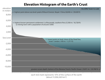
Elevation histogram of the surface of the Earth—approximately 71% of the Earth's surface is covered with water.
 
The pedosphere is the outermost layer of the Earth that is composed of soil and subject to soil formation processes. It exists at the interface of the lithosphere, atmosphere, hydrosphere, and biosphere. Currently the total arable land is 13.31% of the land surface, with only 4.71% supporting permanent crops. Close to 40% of the Earth's land surface is presently used for cropland and pasture, or an estimated 13 million square kilometres (5.0 million square miles) of cropland and 34 million square kilometres (13 million square miles) of pastureland.

The physical features of land are remarkably varied. The largest mountain ranges—the Himalayas in Asia and the Andes in South America—extend for thousands of kilometres. The longest rivers are the river Nile in Africa (6,695 kilometres or 4,160 miles) and the Amazon river in South America (6,437 kilometres or 4,000 miles). Deserts cover about 20% of the total land area. The largest is the Sahara, which covers nearly one-third of Africa.

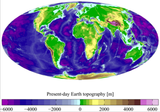
The elevation of the land surface of the Earth varies from the low point of −418 m (−1,371 ft) at the Dead Sea, to a 2005-estimated maximum altitude of 8,848 m (29,028 ft) at the top of Mount Everest. The mean height of land above sea level is 686 m (2,250 ft).

The geological history of Earth can be broadly classified into two periods namely:
  • Precambrian: includes approximately 90% of geologic time. It extends from 4.6 billion years ago to the beginning of the Cambrian Period (about 570 Ma). It is generally believed that small proto-continents existed prior to 3000 Ma, and that most of the Earth's landmasses collected into a single supercontinent around 1000 Ma.
  • Phanerozoic: is the current eon in the geologic timescale. It covers roughly 545 million years. During the period covered, continents drifted about, eventually collected into a single landmass known as Pangea and then split up into the current continental landmasses.

Mars

Rock strewn surface imaged by Mars Pathfinder
 
The surface of Mars is thought to be primarily composed of basalt, based upon the observed lava flows from volcanos, the Martian meteorite collection, and data from landers and orbital observations. The lava flows from Martian volcanos show that that lava has a very low viscosity, typical of basalt. Analysis of the soil samples collected by the Viking landers in 1976 indicate iron-rich clays consistent with weathering of basaltic rocks. There is some evidence that some portion of the Martian surface might be more silica-rich than typical basalt, perhaps similar to andesitic rocks on Earth, though these observations may also be explained by silica glass, phyllosilicates, or opal. Much of the surface is deeply covered by dust as fine as talcum powder. The red/orange appearance of Mars' surface is caused by iron(III) oxide (rust). Mars has twice as much iron oxide in its outer layer as Earth does, despite their supposed similar origin. It is thought that Earth, being hotter, transported much of the iron downwards in the 1,800 kilometres (1,118 mi) deep, 3,200 °C (5,792 °F), lava seas of the early planet, while Mars, with a lower lava temperature of 2,200 °C (3,992 °F) was too cool for this to happen.

The core is surrounded by a silicate mantle that formed many of the tectonic and volcanic features on the planet. The average thickness of the planet's crust is about 50 km, and it is no thicker than 125 kilometres (78 mi), which is much thicker than Earth's crust which varies between 5 kilometres (3 mi) and 70 kilometres (43 mi). As a result, Mars' crust does not easily deform, as was shown by the recent radar map of the south polar ice cap which does not deform the crust despite being about 3 km thick.

Yuty impact crater with typical rampart ejecta
 
Crater morphology provides information about the physical structure and composition of the surface. Impact craters allow us to look deep below the surface and into Mars geological past. Lobate ejecta blankets (pictured left) and central pit craters are common on Mars but uncommon on the Moon, which may indicate the presence of near-surface volatiles (ice and water) on Mars. Degraded impact structures record variations in volcanic, fluvial, and aeolian activity.

The Yuty crater is an example of a Rampart crater so called because of the rampart like edge of the ejecta. In the Yuty crater the ejecta completely covers an older crater at its side, showing that the ejected material is just a thin layer.

The geological history of Mars can be broadly classified into many epochs, but the following are the three major ones:
  1. Noachian epoch (named after Noachis Terra): Formation of the oldest extant surfaces of Mars, 3.8 billion years ago to 3.5 billion years ago. Noachian age surfaces are scarred by many large impact craters. The Tharsis bulge volcanic upland is thought to have formed during this period, with extensive flooding by liquid water late in the epoch.
  2. Hesperian epoch (named after Hesperia Planum): 3.5 billion years ago to 1.8 billion years ago. The Hesperian epoch is marked by the formation of extensive lava plains.
  3. Amazonian epoch (named after Amazonis Planitia): 1.8 billion years ago to present. Amazonian regions have few meteorite impact craters but are otherwise quite varied. Olympus Mons, the largest volcano in the known Universe, formed during this period along with lava flows elsewhere on Mars.

Ceres

The geology of the dwarf planet, Ceres, was largely unknown until Dawn spacecraft explored it in early 2015. However, certain surface features such as "Piazzi", named after the dwarf planets' discoverer, had been resolved.[a] Ceres's oblateness is consistent with a differentiated body, a rocky core overlain with an icy mantle. This 100-kilometer-thick mantle (23%–28% of Ceres by mass; 50% by volume) contains 200 million cubic kilometers of water, which is more than the amount of fresh water on Earth. This result is supported by the observations made by the Keck telescope in 2002 and by evolutionary modeling. Also, some characteristics of its surface and history (such as its distance from the Sun, which weakened solar radiation enough to allow some fairly low-freezing-point components to be incorporated during its formation), point to the presence of volatile materials in the interior of Ceres. It has been suggested that a remnant layer of liquid water may have survived to the present under a layer of ice. The surface composition of Ceres is broadly similar to that of C-type asteroids. Some differences do exist. The ubiquitous features of the Cererian IR spectra are those of hydrated materials, which indicate the presence of significant amounts of water in the interior. Other possible surface constituents include iron-rich clay minerals (cronstedtite) and carbonate minerals (dolomite and siderite), which are common minerals in carbonaceous chondrite meteorites. The spectral features of carbonates and clay minerals are usually absent in the spectra of other C-type asteroids. Sometimes Ceres is classified as a G-type asteroid.

The Cererian surface is relatively warm. The maximum temperature with the Sun overhead was estimated from measurements to be 235 K (about −38 °C, −36 °F) on 5 May 1991.

Prior to the Dawn mission, only a few Cererian surface features had been unambiguously detected. High-resolution ultraviolet Hubble Space Telescope images taken in 1995 showed a dark spot on its surface, which was nicknamed "Piazzi" in honor of the discoverer of Ceres. This was thought to be a crater. Later near-infrared images with a higher resolution taken over a whole rotation with the Keck telescope using adaptive optics showed several bright and dark features moving with Ceres's rotation. Two dark features had circular shapes and are presumably craters; one of them was observed to have a bright central region, whereas another was identified as the "Piazzi" feature. More recent visible-light Hubble Space Telescope images of a full rotation taken in 2003 and 2004 showed 11 recognizable surface features, the natures of which are currently unknown. One of these features corresponds to the "Piazzi" feature observed earlier. 

These last observations also determined that the north pole of Ceres points in the direction of right ascension 19 h 24 min (291°), declination +59°, in the constellation Draco. This means that Ceres's axial tilt is very small—about 3°. 

Atmosphere There are indications that Ceres may have a tenuous atmosphere and water frost on the surface. Surface water ice is unstable at distances less than 5 AU from the Sun, so it is expected to sublime if it is exposed directly to solar radiation. Water ice can migrate from the deep layers of Ceres to the surface, but escapes in a very short time. As a result, it is difficult to detect water vaporization. Water escaping from polar regions of Ceres was possibly observed in the early 1990s but this has not been unambiguously demonstrated. It may be possible to detect escaping water from the surroundings of a fresh impact crater or from cracks in the subsurface layers of Ceres. Ultraviolet observations by the IUE spacecraft detected statistically significant amounts of hydroxide ions near the Cererean north pole, which is a product of water-vapor dissociation by ultraviolet solar radiation.
In early 2014, using data from the Herschel Space Observatory, it was discovered that there are several localized (not more than 60 km in diameter) mid-latitude sources of water vapor on Ceres, which each give off about 1026 molecules (or 3 kg) of water per second. Two potential source regions, designated Piazzi (123°E, 21°N) and Region A (231°E, 23°N), have been visualized in the near infrared as dark areas (Region A also has a bright center) by the W. M. Keck Observatory. Possible mechanisms for the vapor release are sublimation from about 0.6 km2 of exposed surface ice, or cryovolcanic eruptions resulting from radiogenic internal heat or from pressurization of a subsurface ocean due to growth of an overlying layer of ice. Surface sublimation would be expected to decline as Ceres recedes from the Sun in its eccentric orbit, whereas internally powered emissions should not be affected by orbital position. The limited data available are more consistent with cometary-style sublimation. The spacecraft Dawn is approaching Ceres at aphelion, which may constrain Dawn's ability to observe this phenomenon.

Note: This info was taken directly from the main article, sources for the material are included there.

Small Solar System bodies

Asteroids, comets, and meteoroids are all debris remaining from the nebula in which the Solar System formed 4.6 billion years ago.

Asteroid belt

Image of the main asteroid belt and the Trojan asteroids
 
The asteroid belt is located between Mars and Jupiter. It is made of thousands of rocky planetesimals from 1,000 kilometres (621 mi) to a few meters across. These are thought to be debris of the formation of the Solar System that could not form a planet due to Jupiter's gravity. When asteroids collide they produce small fragments that occasionally fall on Earth. These rocks are called meteorites and provide information about the primordial solar nebula. Most of these fragments have the size of sand grains. They burn up in the Earth's atmosphere, causing them to glow like meteors.

Comets

A comet is a small Solar System body that orbits the Sun and (at least occasionally) exhibits a coma (or atmosphere) and/or a tail—both primarily from the effects of solar radiation upon the comet's nucleus, which itself is a minor body composed of rock, dust, and ice.

Kuiper belt

The Kuiper belt, sometimes called the Edgeworth–Kuiper belt, is a region of the Solar System beyond the planets extending from the orbit of Neptune (at 30 AU) to approximately 55 AU from the Sun. It is similar to the asteroid belt, although it is far larger; 20 times as wide and 20–200 times as massive. Like the asteroid belt, it consists mainly of small bodies (remnants from the Solar System's formation) and at least one dwarf planetPluto, which may be geologically active. But while the asteroid belt is composed primarily of rock and metal, the Kuiper belt is composed largely of ices, such as methane, ammonia, and water. The objects within the Kuiper belt, together with the members of the scattered disc and any potential Hills cloud or Oort cloud objects, are collectively referred to as trans-Neptunian objects (TNOs). Two TNOs have been visited and studied at close range, Pluto and Ultima Thule.

United States labor law

From Wikipedia, the free encyclopedia https://en.wikipedia.org/wiki/Uni...