Search This Blog

Friday, July 12, 2019

Kashmir

From Wikipedia, the free encyclopedia
 
Political map of the Kashmir region districts, showing the Pir Panjal range and the Kashmir Valley or Vale of Kashmir.
 
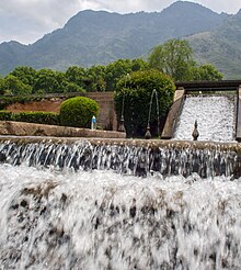
Pahalgam Valley, Kashmir.
 
Nanga Parbat in Kashmir, the ninth-highest mountain on Earth, is the western anchor of the Himalayas.
 
The Karakash River (Black Jade River) which flows north from its source near the town of Sumde in Aksai Chin, to cross the Kunlun Mountains.
 
Kashmir is the northernmost geographical region of the Indian subcontinent. Until the mid-19th century, the term "Kashmir" denoted only the Kashmir Valley between the Great Himalayas and the Pir Panjal Range. Today, it denotes a larger area that includes the Indian-administered territory of Jammu and Kashmir (which includes the divisions Jammu, Kashmir Valley, and Ladakh), the Pakistani-administered territories of Azad Kashmir and Gilgit-Baltistan, and Chinese-administered territories of Aksai Chin and the Trans-Karakoram Tract.

In the first half of the 1st millennium, the Kashmir region became an important centre of Hinduism and later of Buddhism; later still, in the ninth century, Kashmir Shaivism arose. In 1339, Shah Mir became the first Muslim ruler of Kashmir, inaugurating the Salatin-i-Kashmir or Shah Mir dynasty. Kashmir was part of the Mughal Empire from 1586 to 1751, and thereafter, until 1820, of the Afghan Durrani Empire. That year, the Sikhs, under Ranjit Singh, annexed Kashmir. In 1846, after the Sikh defeat in the First Anglo-Sikh War, and upon the purchase of the region from the British under the Treaty of Amritsar, the Raja of Jammu, Gulab Singh, became the new ruler of Kashmir. The rule of his descendants, under the paramountcy (or tutelage) of the British Crown, lasted until the partition of India in 1947, when the former princely state of the British Indian Empire became a disputed territory, now administered by three countries: India, Pakistan, and China.

Etymology

The word Kashmir was derived from the ancient Sanskrit language and was referred to as káśmīra. The Nilamata Purana describes the Valley's origin from the waters, a lake called Sati-saras. A popular, but uncertain, local etymology of Kashmira is that it is land desiccated from water.

An alternative, but also uncertain, etymology derives the name from the name of the Hindu sage Kashyapa who is believed to have settled people in this land. Accordingly, Kashmir would be derived from either kashyapa-mir (Kashyapa's Lake) or kashyapa-meru (Kashyapa's Mountain).

The word has been referenced to in a Hindu scripture mantra worshipping the Hindu goddess Sharada and is mentioned to have resided in the land of kashmira,or which might have been a reference to the Sharada Peeth

The Ancient Greeks called the region Kasperia which has been identified with Kaspapyros of Hecataeus of Miletus (apud Stephanus of Byzantium) and Kaspatyros of Herodotus (3.102, 4.44). Kashmir is also believed to be the country meant by Ptolemy's Kaspeiria. The earliest text which directly mentions the name Kashmir is in Ashtadhyayi written by a Sanskrit grammarian Pāṇini during 5th century BC. Pāṇini called the people of Kashmir as Kashmirikas. Some other early references to Kashmir can also be found in Mahabharata in Sabha Parva and in puranas like Matsya Purana, Vayu Purana, Padma Purana and Vishnu Purana and Vishnudharmottara Purana.

Huientsang, the Buddhist scholar and Chinese traveller called Kashmir as kia-shi-milo, while some other Chinese accounts referred Kashmir as ki-pin and ache-pin.

Cashmere is an archaic spelling of present-Kashmir, and in some countries it is still spelled this way.
In the Kashmiri language, Kashmir itself is known as Kasheer.

History

Hinduism and Buddhism in Kashmir

This general view of the unexcavated Buddhist stupa near Baramulla, with two figures standing on the summit, and another at the base with measuring scales, was taken by John Burke in 1868. The stupa, which was later excavated, dates to 500 CE.
 
During ancient and medieval period, Kashmir has been an important centre for the development of a Hindu-Buddhist syncretism, in which Madhyamaka and Yogachara were blended with Shaivism and Advaita Vedanta. The Buddhist Mauryan emperor Ashoka is often credited with having founded the old capital of Kashmir, Shrinagari, now ruins on the outskirts of modern Srinagar. Kashmir was long to be a stronghold of Buddhism. As a Buddhist seat of learning, the Sarvastivada school strongly influenced Kashmir. East and Central Asian Buddhist monks are recorded as having visited the kingdom. In the late 4th century CE, the famous Kuchanese monk Kumārajīva, born to an Indian noble family, studied Dīrghāgama and Madhyāgama in Kashmir under Bandhudatta. He later became a prolific translator who helped take Buddhism to China. His mother Jīva is thought to have retired to Kashmir. Vimalākṣa, a Sarvāstivādan Buddhist monk, travelled from Kashmir to Kucha and there instructed Kumārajīva in the Vinayapiṭaka

Martand Sun Temple Central shrine, dedicated to the deity Surya. The temple complex was built by the third ruler of the Karkota dynasty, Emperor Lalitaditya Muktapida, in the 8th century CE. It is one of the largest temple complexes on the Indian subcontinent.
 
Ruins of the Martand Sun Temple. The temple was completely destroyed on the orders of Muslim Sultan Sikandar Butshikan in the early 15th century, with demolition lasting a year.
 
Karkoṭa Empire (625 CE – 885 CE) was a powerful Hindu empire, which originated in the region of Kashmir. It was founded by Durlabhvardhana during the lifetime of Harsha. The dynasty marked the rise of Kashmir as a power in South Asia. Avanti Varman ascended the throne of Kashmir on 855 CE, establishing the Utpala dynasty and ending the rule of Karkoṭa dynasty.

According to tradition, Adi Shankara visited the pre-existing Sarvajñapīṭha (Sharada Peeth) in Kashmir in the late 8th century or early 9th century CE. The Madhaviya Shankaravijayam states this temple had four doors for scholars from the four cardinal directions. The southern door of Sarvajna Pitha was opened by Adi Shankara. According to tradition, Adi Shankara opened the southern door by defeating in debate all the scholars there in all the various scholastic disciplines such as Mīmāṃsā, Vedanta and other branches of Hindu philosophy; he ascended the throne of Transcendent wisdom of that temple.

Abhinavagupta (c. 950–1020 CE) was one of India's greatest philosophers, mystics and aestheticians. He was also considered an important musician, poet, dramatist, exegete, theologian, and logician – a polymathic personality who exercised strong influences on Indian culture. He was born in the Kashmir Valley in a family of scholars and mystics and studied all the schools of philosophy and art of his time under the guidance of as many as fifteen (or more) teachers and gurus. In his long life he completed over 35 works, the largest and most famous of which is Tantrāloka, an encyclopaedic treatise on all the philosophical and practical aspects of Trika and Kaula (known today as Kashmir Shaivism). Another one of his very important contributions was in the field of philosophy of aesthetics with his famous Abhinavabhāratī commentary of Nāṭyaśāstra of Bharata Muni.

In the 10th century Mokshopaya or Moksopaya Shastra, a philosophical text on salvation for non-ascetics (moksa-upaya: 'means to release'), was written on the Pradyumna hill in Srinagar. It has the form of a public sermon and claims human authorship and contains about 30,000 shloka's (making it longer than the Ramayana). The main part of the text forms a dialogue between Vashistha and Rama, interchanged with numerous short stories and anecdotes to illustrate the content. This text was later (11th to the 14th century CE) expanded and vedanticised, which resulted in the Yoga Vasistha.

Queen Kota Rani was medieval Hindu ruler of Kashmir, ruling until 1339. She was a notable ruler who is often credited for saving Srinagar city from frequent floods by getting a canal constructed, named after her "Kutte Kol". This canal receives water from Jhelum River at the entry point of city and again merges with Jhelum river beyond the city limits.

Shah Mir Dynasty

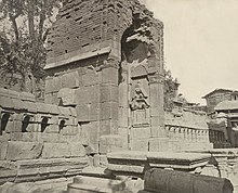
Gateway of enclosure, (once a Hindu temple) of Zein-ul-ab-ud-din's Tomb, in Srinagar. Probable date 400 to 500 CE, 1868. John Burke. Oriental and India Office Collection. British Library.
 
Shams-ud-Din Shah Mir (reigned 1339–42) was the first Muslim ruler of Kashmir and founder of the Shah Mir dynasty. Kashmiri historian Jonaraja, in his Dvitīyā Rājataraṅginī mentioned Shah Mir was from the country of Panchagahvara (identified as the Panjgabbar valley between Rajouri and Budhal), and his ancestors were Kshatriya, who converted to Islam. Scholar A. Q. Rafiqi states:
Shāh Mīr arrived in Kashmir in 1313, along with his family, during the reign of Sūhadeva (1301–20), whose service he entered. In subsequent years, through his tact and ability, Shāh Mīr rose to prominence and became one of the important personalities of the time. Later, after the death in 1338 of Udayanadeva, the brother of Sūhadeva, he was able to assume the kingship himself and thus laid the foundation of permanent Muslim rule in Kashmir. Dissensions among the ruling classes and foreign invasions were the two main factors which contributed towards the establishment of Muslim rule in Kashmir.
Rinchan, from Ladakh, and Lankar Chak, from Dard territory near Gilgit, came to Kashmir and played a notable role in the subsequent political history of the Valley. All the three men were granted Jagirs (feudatory estates) by the King. Rinchan became the ruler of Kashmir for three years. 

Shah Mir was the first ruler of Shah Mir dynasty, which had established in 1339 CE. Muslim ulama, such as Mir Sayyid Ali Hamadani, arrived from Central Asia to proselytize in Kashmir and their efforts converted thousands of Kashmiris to Islam and Hamadani's son also convinced Sikander Butshikan to enforce Islamic law. By the late 1400s most Kashmiris had accepted Islam. Persian was introduced in Kashmir by the Šāh-Miri dynasty (1349-1561) and started to flourish under Sultan Zayn-al-ʿĀbedin (1420-70).

Mughal rule

Nishat Bagh, a Mughal Garden built by the Mughal emperor Shah Jahan in Srinagar, Kashmir
 
The Mughal padishah (emperor) Akbar conquered Kashmir from 1585-86, taking advantage of Kashmir's internal Sunni-Shia divisions, and thus ended indigenous Kashmiri Muslim rule. Akbar added it to the Kabul Subah (encompassing modern-day northeastern Afghanistan, northern Pakistan and the Kashmir Valley of India), but Shah Jahan carved it out as a separate subah (imperial top-level province) with its seat at Srinagar. Kashmir became the northern-most region of Mughal India as well as a pleasure ground in the summertime. They built Persian water-gardens in Srinagar, along the shores of Dal Lake, with cool and elegantly proportioned terraces, fountains, roses, jasmine and rows of chinar trees.

Afghan rule

Coin of Timur Shah Durrani (r1772–1793), minted in Kashmir, dated 1787
 
The Afghan Durrani dynasty's Durrani Empire controlled Kashmir from 1751, when weakling 15th Mughal padshah (emperor) Ahmad Shah Bahadur's viceroy Muin-ul-Mulk was defeated and reinstated by the Durrani founder Ahmad Shah Durrani (who conquered, roughly, modern day Afghanistan and Pakistan from the Mughals and local rulers), until the 1820 Sikh triumph. The Afghan rulers brutally repressed Kashmiris of all faiths (according to Kashmiri historians).

Sikh rule

In 1819, the Kashmir Valley passed from the control of the Durrani Empire of Afghanistan to the conquering armies of the Sikhs under Ranjit Singh of the Punjab, thus ending four centuries of Muslim rule under the Mughals and the Afghan regime. As the Kashmiris had suffered under the Afghans, they initially welcomed the new Sikh rulers. However, the Sikh governors turned out to be hard taskmasters, and Sikh rule was generally considered oppressive, protected perhaps by the remoteness of Kashmir from the capital of the Sikh Empire in Lahore. The Sikhs enacted a number of anti-Muslim laws, which included handing out death sentences for cow slaughter, closing down the Jamia Masjid in Srinagar, and banning the adhan, the public Muslim call to prayer. Kashmir had also now begun to attract European visitors, several of whom wrote of the abject poverty of the vast Muslim peasantry and of the exorbitant taxes under the Sikhs. High taxes, according to some contemporary accounts, had depopulated large tracts of the countryside, allowing only one-sixteenth of the cultivable land to be cultivated. Many Kashmiri peasants migrated to the plains of the Punjab. However, after a famine in 1832, the Sikhs reduced the land tax to half the produce of the land and also began to offer interest-free loans to farmers; Kashmir became the second highest revenue earner for the Sikh Empire. During this time Kashmiri shawls became known worldwide, attracting many buyers, especially in the West.

The state of Jammu, which had been on the ascendant after the decline of the Mughal Empire, came under the sway of the Sikhs in 1770. Further in 1808, it was fully conquered by Maharaja Ranjit Singh. Gulab Singh, then a youngster in the House of Jammu, enrolled in the Sikh troops and, by distinguishing himself in campaigns, gradually rose in power and influence. In 1822, he was anointed as the Raja of Jammu. Along with his able general Zorawar Singh Kahluria, he conquered and subdued Rajouri (1821), Kishtwar (1821), Suru valley and Kargil (1835), Ladakh (1834–1840), and Baltistan (1840), thereby surrounding the Kashmir Valley. He became a wealthy and influential noble in the Sikh court.

Princely state

1909 Map of the Princely State of Kashmir and Jammu. The names of regions, important cities, rivers, and mountains are underlined in red.
 
In 1845, the First Anglo-Sikh War broke out. According to The Imperial Gazetteer of India,
"Gulab Singh contrived to hold himself aloof till the battle of Sobraon (1846), when he appeared as a useful mediator and the trusted advisor of Sir Henry Lawrence. Two treaties were concluded. By the first the State of Lahore (i.e. West Punjab) handed over to the British, as equivalent for one crore indemnity, the hill countries between the rivers Beas and Indus; by the second the British made over to Gulab Singh for 75 lakhs all the hilly or mountainous country situated to the east of the Indus and the west of the Ravi i.e. the Vale of Kashmir)."
Drafted by a treaty and a bill of sale, and constituted between 1820 and 1858, the Princely State of Kashmir and Jammu (as it was first called) combined disparate regions, religions, and ethnicities: to the east, Ladakh was ethnically and culturally Tibetan and its inhabitants practised Buddhism; to the south, Jammu had a mixed population of Hindus, Muslims and Sikhs; in the heavily populated central Kashmir valley, the population was overwhelmingly Sunni Muslim, however, there was also a small but influential Hindu minority, the Kashmiri brahmins or pandits; to the northeast, sparsely populated Baltistan had a population ethnically related to Ladakh, but which practised Shia Islam; to the north, also sparsely populated, Gilgit Agency, was an area of diverse, mostly Shi'a groups; and, to the west, Punch was Muslim, but of different ethnicity than the Kashmir valley. After the Indian Rebellion of 1857, in which Kashmir sided with the British, and the subsequent assumption of direct rule by Great Britain, the princely state of Kashmir came under the suzerainty of the British Crown

In the British census of India of 1941, Kashmir registered a Muslim majority population of 77%, a Hindu population of 20% and a sparse population of Buddhists and Sikhs comprising the remaining 3%. That same year, Prem Nath Bazaz, a Kashmiri Pandit journalist wrote: “The poverty of the Muslim masses is appalling. ... Most are landless laborers, working as serfs for absentee [Hindu] landlords ... Almost the whole brunt of official corruption is borne by the Muslim masses.” Under the Hindu rule, Muslims faced hefty taxation, discrimination in the legal system and were forced into labor without any wages. Conditions in the princely state caused a significant migration of people from the Kashmir Valley to Punjab of British India. For almost a century until the census, a small Hindu elite had ruled over a vast and impoverished Muslim peasantry. Driven into docility by chronic indebtedness to landlords and moneylenders, having no education besides, nor awareness of rights, the Muslim peasants had no political representation until the 1930s.

1947 and 1948

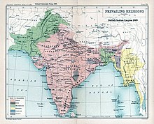
The prevailing religions by district in the 1901 Census of the Indian Empire.
 
Ranbir Singh's grandson Hari Singh, who had ascended the throne of Kashmir in 1925, was the reigning monarch in 1947 at the conclusion of British rule of the subcontinent and the subsequent partition of the British Indian Empire into the newly independent Dominion of India and the Dominion of Pakistan

In the run up to 1947 partition, there were two major parties in the princely state: the National Conference and the Muslim Conference. The former was led by the charismatic Kashmiri leader Sheikh Abdullah, who tilted towards the accession of the state to India, whilst the latter tilted towards accession to Pakistan. The National Conference enjoyed popular support in the Kashmir Valley whilst the Muslim Conference was more popular in the Jammu region. The Hindus and Sikhs of the state were firmly in favour of joining India, as were the Buddhists. However, the sentiments of the state's Muslim population were divided. Scholar Christopher Snedden states that the Muslims of Western Jammu, and also the Muslims of the Frontier Districts Province, strongly wanted Jammu and Kashmir to join Pakistan. The ethnic Kashmiri Muslims of the Kashmir Valley, on the other hand, were ambivalent about Pakistan (possibly due to their secular nature). The fact that Kashmiris were not particularly enamoured with the idea of Pakistan reflected the failure of the idea of Pan-Islamic identity in satisfying the political urges of Kashmiris. At the same time there was also a lack of interest in merging with Indian nationalism.

According to Burton Stein's History of India,
"Kashmir was neither as large nor as old an independent state as Hyderabad; it had been created rather off-handedly by the British after the first defeat of the Sikhs in 1846, as a reward to a former official who had sided with the British. The Himalayan kingdom was connected to India through a district of the Punjab, but its population was 77 per cent Muslim and it shared a boundary with Pakistan. Hence, it was anticipated that the maharaja would accede to Pakistan when the British paramountcy ended on 14–15 August. When he hesitated to do this, Pakistan launched a guerrilla onslaught meant to frighten its ruler into submission. Instead the Maharaja appealed to Mountbatten for assistance, and the governor-general agreed on the condition that the ruler accede to India. Indian soldiers entered Kashmir and drove the Pakistani-sponsored irregulars from all but a small section of the state. The United Nations was then invited to mediate the quarrel. The UN mission insisted that the opinion of Kashmiris must be ascertained, while India insisted that no referendum could occur until all of the state had been cleared of irregulars."
In the last days of 1948, a ceasefire was agreed under UN auspices. However, since the referendum demanded by the UN was never conducted, relations between India and Pakistan soured, and eventually led to two more wars over Kashmir in 1965 and 1999

Topographic map of Kashmir

Current status and political divisions

India has control of about half the area of the former princely state of Jammu and Kashmir, which continues the name Jammu and Kashmir, while Pakistan controls a third of the region, divided into two de facto provinces, Gilgit-Baltistan and Azad Kashmir

According to the Encyclopædia Britannica, "Although there was a clear Muslim majority in Kashmir before the 1947 partition and its economic, cultural, and geographic contiguity with the Muslim-majority area of the Punjab (in Pakistan) could be convincingly demonstrated, the political developments during and after the partition resulted in a division of the region. Pakistan was left with territory that, although basically Muslim in character, was thinly populated, relatively inaccessible, and economically underdeveloped. The largest Muslim group, situated in the Valley of Kashmir and estimated to number more than half the population of the entire region, lay in Indian-administered territory, with its former outlets via the Jhelum valley route blocked."

The eastern region of the former princely state of Kashmir is also involved in a boundary dispute that began in the late 19th century and continues into the 21st. Although some boundary agreements were signed between Great Britain, Afghanistan and Russia over the northern borders of Kashmir, China never accepted these agreements, and China's official position has not changed following the communist revolution of 1949 that established the People's Republic of China. By the mid-1950s the Chinese army had entered the north-east portion of Ladakh:
"By 1956–57 they had completed a military road through the Aksai Chin area to provide better communication between Xinjiang and western Tibet. India's belated discovery of this road led to border clashes between the two countries that culminated in the Sino-Indian war of October 1962."
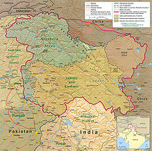
The region is divided amongst three countries in a territorial dispute: Pakistan controls the northwest portion (Northern Areas and Kashmir), India controls the central and southern portion (Jammu and Kashmir) and Ladakh, and the People's Republic of China controls the northeastern portion (Aksai Chin and the Trans-Karakoram Tract). India controls the majority of the Siachen Glacier area, including the Saltoro Ridge passes, whilst Pakistan controls the lower territory just southwest of the Saltoro Ridge. India controls 101,338 km2 (39,127 sq mi) of the disputed territory, Pakistan controls 85,846 km2 (33,145 sq mi), and the People's Republic of China controls the remaining 37,555 km2 (14,500 sq mi). 

Jammu and Azad Kashmir lie outside Pir Panjal range, and are under Indian and Pakistani control respectively. These are populous regions. Gilgit–Baltistan, formerly known as the Northern Areas, is a group of territories in the extreme north, bordered by the Karakoram, the western Himalayas, the Pamir, and the Hindu Kush ranges. With its administrative centre in the town of Gilgit, the Northern Areas cover an area of 72,971 square kilometres (28,174 sq mi) and have an estimated population approaching 1 million (10 lakhs). 

Ladakh is a region in the east, between the Kunlun mountain range in the north and the main Great Himalayas to the south. Main cities are Leh and Kargil. It is under Indian administration and is part of the state of Jammu and Kashmir. It is one of the most sparsely populated regions in the area and is mainly inhabited by people of Indo-Aryan and Tibetan descent. Aksai Chin is a vast high-altitude desert of salt that reaches altitudes up to 5,000 metres (16,000 ft). Geographically part of the Tibetan Plateau, Aksai Chin is referred to as the Soda Plain. The region is almost uninhabited, and has no permanent settlements. 

Though these regions are in practice administered by their respective claimants, neither India nor Pakistan has formally recognised the accession of the areas claimed by the other. India claims those areas, including the area "ceded" to China by Pakistan in the Trans-Karakoram Tract in 1963, are a part of its territory, while Pakistan claims the entire region excluding Aksai Chin and Trans-Karakoram Tract. The two countries have fought several declared wars over the territory. The Indo-Pakistani War of 1947 established the rough boundaries of today, with Pakistan holding roughly one-third of Kashmir, and India one-half, with a dividing line of control established by the United Nations. The Indo-Pakistani War of 1965 resulted in a stalemate and a UN-negotiated ceasefire.

Demographics

In the 1901 Census of the British Indian Empire, the population of the princely state of Kashmir and Jammu was 2,905,578. Of these, 2,154,695 (74.16%) were Muslims, 689,073 (23.72%) Hindus, 25,828 (0.89%) Sikhs, and 35,047 (1.21%) Buddhists (implying 935 (0.032%) others). 

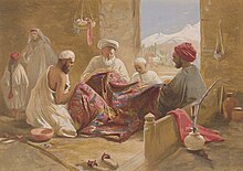
A Muslim shawl-making family shown in Cashmere shawl manufactory, 1867, chromolith., William Simpson.
 
A group of Kashmiri Pandits, natives of Kashmir Valley belong to one of the prominent Shaiva sects of Hinduism, shown in 1895.
 
Among the Muslims of the Kashmir province within the princely state, four divisions were recorded: "Shaikhs, Saiyids, Mughals, and Pathans. The Shaikhs, who are by far the most numerous, are the descendants of Hindus, but have retained none of the caste rules of their forefathers. They have clan names known as krams ..." These kram names included "Tantre", "Shaikh", "Bat", "Manto", "Ganai", "Dar", "Lon", "Wani" etc. The Saiyids "could be divided into those who follow the profession of religion and those who have taken to agriculture and other pursuits. Their kram name is 'Mir.' While a Saiyid retains his saintly profession Mir is a prefix; if he has taken to agriculture, Mir is an affix to his name." The Mughals who were not numerous had kram names like "Mir" (a corruption of "Mirza"), "Beg", "Bandi", "Bach" and "Ashaye". Finally, it was recorded that the Pathans "who are more numerous than the Mughals, ... are found chiefly in the south-west of the valley, where Pathan colonies have from time to time been founded. The most interesting of these colonies is that of Kuki-Khel Afridis at Dranghaihama, who retain all the old customs and speak Pashto." Among the main tribes of Muslims in the princely state are the Butts, Dar, Lone, Jat, Gujjar, Rajput, Sudhan and Khatri. Some Kashmiri families belonging to Butt, Lone and Wani/Wain clans use the title of Khawaja which was given to them by Mughal governors as these families were associated with Mughal Darbar. The Khatri use the title Shaikh and the Gujjar use the title Chaudhary. All these tribes are indigenous to the princely state which converted to Islam from Hinduism during its arrival in the region. 

The Hindus were found mainly in Jammu, where they constituted a little less than 60% of the population. In the Kashmir Valley, the Hindus represented "524 in every 10,000 of the population (i.e. 5.24%), and in the frontier wazarats of Ladhakh and Gilgit only 94 out of every 10,000 persons (0.94%)." In the same Census of 1901, in the Kashmir Valley, the total population was recorded to be 1,157,394, of which the Muslim population was 1,083,766, or 93.6% and the Hindu population 60,641. Among the Hindus of Jammu province, who numbered 626,177 (or 90.87% of the Hindu population of the princely state), the most important castes recorded in the census were "Brahmans (186,000), the Rajputs (167,000), the Khattris (48,000) and the Thakkars (93,000)."

In the 1911 Census of the British Indian Empire, the total population of Kashmir and Jammu had increased to 3,158,126. Of these, 2,398,320 (75.94%) were Muslims, 696,830 (22.06%) Hindus, 31,658 (1%) Sikhs, and 36,512 (1.16%) Buddhists. In the last census of British India in 1941, the total population of Kashmir and Jammu (which as a result of the second world war, was estimated from the 1931 census) was 3,945,000. Of these, the total Muslim population was 2,997,000 (75.97%), the Hindu population was 808,000 (20.48%), and the Sikh 55,000 (1.39%).

The Kashmiri Pandits, the only Hindus of the Kashmir valley, who had stably constituted approximately 4 to 5% of the population of the valley during Dogra rule (1846–1947), and 20% of whom had left the Kashmir valley by 1950, began to leave in much greater numbers in the 1990s. According to a number of authors, approximately 100,000 of the total Kashmiri Pandit population of 140,000 left the valley during that decade. Other authors have suggested a higher figure for the exodus, ranging from the entire population of over 150 to 190 thousand (1.5 to 190,000) of a total Pandit population of 200 thousand (200,000) to a number as high as 300 thousand (300,000). 

People in Jammu speak Hindi, Punjabi and Dogri, the Vale of Kashmir speaks Kashmiri and the sparsely inhabited Ladakh region speaks Tibetan and Balti.

The total population of India's division of Jammu and Kashmir is 12,541,302 and Pakistan's division of Kashmir is 2,580,000 and Gilgit-Baltistan is 870,347.

Brokpa women from Kargil, northern Ladakh, in local costumes

Economy

Srinagar, the largest city of Kashmir

Kashmir's economy is centred around agriculture. Traditionally the staple crop of the valley was rice, which formed the chief food of the people. In addition, Indian corn, wheat, barley and oats were also grown. Given its temperate climate, it is suited for crops like asparagus, artichoke, seakale, broad beans, scarletrunners, beetroot, cauliflower and cabbage. Fruit trees are common in the valley, and the cultivated orchards yield pears, apples, peaches, and cherries. The chief trees are deodar, firs and pines, chenar or plane, maple, birch and walnut, apple, cherry. 

Historically, Kashmir became known worldwide when Cashmere wool was exported to other regions and nations (exports have ceased due to decreased abundance of the cashmere goat and increased competition from China). Kashmiris are well adept at knitting and making Pashmina shawls, silk carpets, rugs, kurtas, and pottery. Saffron, too, is grown in Kashmir. Srinagar is known for its silver-work, papier-mâché, wood-carving, and the weaving of silk. The economy was badly damaged by the 2005 Kashmir earthquake which, as of 8 October 2005, resulted in over 70,000 deaths in the Pakistan-controlled part of Kashmir and around 1,500 deaths in Indian controlled Kashmir.

Transport

Transport is predominantly by air or road vehicles in the region. Kashmir has a 135 km (84 mi) long modern railway line that started in October 2009, and was last extended in 2013 and connects Baramulla, in the western part of Kashmir, to Srinagar and Banihal. It is expected to link Kashmir to the rest of India after the construction of the railway line from Katra to Banihal is completed.
Indus River

From Wikipedia, the free encyclopedia
 
Indus
Sindhu
Indus.A2002274.0610.1km.jpg
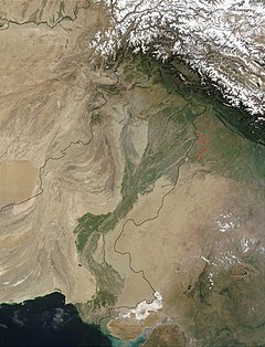
Satellite image of the Indus River basin in Pakistan and India
(International boundaries are superimposed)
Indus River basin map.svg
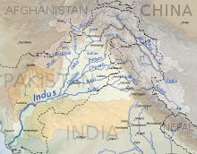
Map of the Indus River basin excluding the tributaries draining in to Rann of Kutch
Location
CountryChina, India, Pakistan
StateJammu and Kashmir, Punjab, Khyber Pakhtunkhwa, Sindh, Gilgit-Baltistan, Tibet
CitiesLeh, Skardu, Dasu, Besham, Thakot, Swabi, Dera Ismail Khan, Sukkur, Hyderabad
Physical characteristics
SourceSênggê Zangbo
 ⁃ locationTibetan Plateau
2nd sourceGar Tsangpo
 ⁃ locationShiquanhe, Ngari Prefecture, Tibet and India
 ⁃ coordinates32°29′54″N 79°41′28″E
 ⁃ elevation4,255 m (13,960 ft)
MouthArabian Sea (primary), Rann of Kutch (secondary)
 ⁃ location
Indus River Delta (primary), Kori Creek (secondary), Pakistan, India
 ⁃ coordinates
23°59′40″N 67°25′51″ECoordinates: 23°59′40″N 67°25′51″E
 ⁃ elevation
0 m (0 ft)
Length2,880 km (1,790 mi)
Basin size1,165,000 km2 (450,000 sq mi)
 ⁃ locationArabian Sea
 ⁃ average6,600 m3/s (230,000 cu ft/s)
 ⁃ minimum1,200 m3/s (42,000 cu ft/s)
 ⁃ maximum58,000 m3/s (2,000,000 cu ft/s)
Basin features
Tributaries 
 ⁃ leftZanskar River, Suru River, Soan River, Jhelum River, Chenab River, Ravi River, Beas River, Sutlej River, Panjnad River, Ghaggar-Hakra River, Luni River
 ⁃ rightShyok River, Hunza River, Gilgit River, Swat River, Kunar River, Kabul River, Kurram River, Gomal River, Zhob River

Indus River in Kharmang District, Pakistan.
 
The Indus River (locally called Sindhu) is one of the longest rivers in Asia. Originating in the Tibetan Plateau in the vicinity of Lake Manasarovar, the river runs a course through the Ladakh region of Jammu and Kashmir, India, towards the Gilgit-Baltistan region of Pakistan and the Hindukush ranges, and then flows in a southerly direction along the entire length of Pakistan to merge into the Arabian Sea near the port city of Karachi in Sindh. It is the longest river and national river of Pakistan.

The river has a total drainage area exceeding 1,165,000 km2 (450,000 sq mi). Its estimated annual flow stands at around 243 km3 (58 cu mi), twice that of the Nile River and three times that of the Tigris and Euphrates rivers combined, making it one of the largest rivers in the world in terms of annual flow. The Zanskar is its left bank tributary in Ladakh. In the plains, its left bank tributary is the Panjnad which itself has five major tributaries, namely, the Chenab, Jhelum, the Ravi, the Beas, and the Sutlej. Its principal right bank tributaries are the Shyok, the Gilgit, the Kabul, the Gomal, and the Kurram. Beginning in a mountain spring and fed with glaciers and rivers in the Himalayan, Karakoram and Hindu Kush ranges, the river supports ecosystems of temperate forests, plains and arid countryside. 

The northern part of the Indus Valley, with its tributaries, forms the Punjab region, while the lower course of the Indus is known as Sindh and ends in a large delta. The river has historically been important to many cultures of the region. The 3rd millennium BC saw the rise of a major urban civilization of the Bronze Age. During the 2nd millennium BC, the Punjab region was mentioned in the hymns of the Hindu Rigveda as Sapta Sindhu and the Zoroastrian Avesta as Hapta Hindu (both terms meaning "seven rivers"). Early historical kingdoms that arose in the Indus Valley include Gandhāra, and the Ror dynasty of Sauvīra. The Indus River came into the knowledge of the West early in the Classical Period, when King Darius of Persia sent his Greek subject Scylax of Caryanda to explore the river, ca. 515 BC.

Etymology and names

This river was known to the ancient Indians in Sanskrit as Sindhu and the Persians as Hindu which was regarded by both of them as "the border river". The variation between the two names is explained by the Old Iranian sound change *s > h, which occurred between 850–600 BCE according to Asko Parpola. From the Persian Achaemenid Empire, the name passed to the Greeks as Indós (Ἰνδός). It was adopted by the Romans as Indus

The meaning of Sindhu as a "large body of water, sea, or ocean" is a later meaning in Classical Sanskrit. A later Persian name for the river was Darya, which similarly has the connotations of large body of water and sea. Other variants of the name Sindhu include Assyrian Sinda (as early as the 7th century BC), Persian Ab-e-sind, Pashto Abasind, Arab Al-Sind, Chinese Sintow, and Javanese Santri.

In other languages of the region, the river is known as सिन्धु (Sindhu) in Hindi and Nepali, سنڌو (Sindhu) in Sindhi, سندھ (Sindh) in Shahmukhi Punjabi, ਸਿੰਧ ਨਦੀ (Sindh Nadī) in Gurmukhī Punjabi, اباسين (Abāsin lit. "Father of Rivers") in Pashto, نهر السند (Nahar al-Sind) in Arabic, སེང་གེ་གཙང་པོ། (singi khamban lit. "Lion River" or Lion Spring) in Tibetan, 印度 (Yìndù) in Chinese, and Nilab in Turki.

Description

Babur crossing the Indus River.
 
The Indus River provides key water resources for Pakistan's economy – especially the breadbasket of Punjab province, which accounts for most of the nation's agricultural production, and Sindh. The word Punjab means "land of five rivers" and the five rivers are Jhelum, Chenab, Ravi, Beas and Sutlej, all of which finally flow into the Indus. The Indus also supports many heavy industries and provides the main supply of potable water in Pakistan. 

The ultimate source of the Indus is in Tibet; the river begins at the confluence of the Sengge Zangbo and Gar Tsangpo rivers that drain the Nganglong Kangri and Gangdise Shan (Gang Rinpoche, Mt. Kailash) mountain ranges. The Indus then flows northwest through Ladakh, India, and Baltistan into Gilgit, just south of the Karakoram range. The Shyok, Shigar and Gilgit rivers carry glacial waters into the main river. It gradually bends to the south and descends into the Punjab plains at Kalabagh, Pakistan. The Indus passes gigantic gorges 4,500–5,200 metres (15,000–17,000 feet) deep near the Nanga Parbat massif. It flows swiftly across Hazara and is dammed at the Tarbela Reservoir. The Kabul River joins it near Attock. The remainder of its route to the sea is in the plains of the Punjab and Sindh, where the flow of the river becomes slow and highly braided. It is joined by the Panjnad at Mithankot. Beyond this confluence, the river, at one time, was named the Satnad River (sat = "seven", nadī = "river"), as the river now carried the waters of the Kabul River, the Indus River and the five Punjab rivers. Passing by Jamshoro, it ends in a large delta to the South of Thatta in the Sindh province of Pakistan.

The Indus is one of the few rivers in the world to exhibit a tidal bore. The Indus system is largely fed by the snows and glaciers of the Himalayas, Karakoram and the Hindu Kush ranges of Tibet, the Indian states of Jammu and Kashmir and Himachal Pradesh and Gilgit-Baltistan region of Pakistan. The flow of the river is also determined by the seasons – it diminishes greatly in the winter, while flooding its banks in the monsoon months from July to September. There is also evidence of a steady shift in the course of the river since prehistoric times – it deviated westwards from flowing into the Rann of Kutch and adjoining Banni grasslands after the 1816 earthquake. Presently, Indus water flows in to the Rann of Kutch during its floods breaching flood banks.

The traditional source of the river is the Senge Khabab or "Lion's Mouth", a perennial spring, not far from the sacred Mount Kailash marked by a long low line of Tibetan chortens. There are several other tributaries nearby, which may possibly form a longer stream than Senge Khabab, but unlike the Senge Khabab, are all dependent on snowmelt. The Zanskar River, which flows into the Indus in Ladakh, has a greater volume of water than the Indus itself before that point.

History

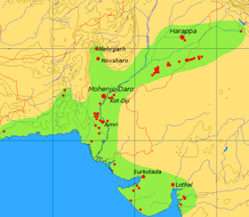
Extent and major sites of the Indus Valley Civilisation 3000 BC

The Rigveda describes several rivers, including one named "Sindhu". The Rigvedic "Sindhu" is thought to be the present-day Indus river. It is attested 176 times in its text, 94 times in the plural, and most often used in the generic sense of "river". In the Rigveda, notably in the later hymns, the meaning of the word is narrowed to refer to the Indus river in particular, e.g. in the list of rivers mentioned in the hymn of Nadistuti sukta. The Rigvedic hymns apply a feminine gender to all the rivers mentioned therein, except the Bramhaputra and the "Sindhu" which carry the masculine gender. This gender usage could mean that the Sindhu river was believed to be a warrior, and thus one of the greatest among all the rivers in the whole world.

The major cities of the Indus Valley Civilisation, such as Harappa and Mohenjo-daro, date back to around 3300 BC, and represent some of the largest human habitations of the ancient world. The Indus Valley Civilisation extended from across northeast Afghanistan to Pakistan and northwest India, with an upward reach from east of Jhelum River to Ropar on the upper Sutlej. The coastal settlements extended from Sutkagan Dor at the Pakistan, Iran border to Kutch in modern Gujarat, India. There is an Indus site on the Amu Darya at Shortughai in northern Afghanistan, and the Indus site Alamgirpur at the Hindon River is located only 28 km (17 mi) from Delhi. To date, over 1,052 cities and settlements have been found, mainly in the general region of the Ghaggar-Hakra River and its tributaries. Among the settlements were the major urban centres of Harappa and Mohenjo-daro, as well as Lothal, Dholavira, Ganeriwala, and Rakhigarhi. Only 90–96 of more than 800 known Indus Valley sites have been discovered on the Indus and its tributaries.[citation needed] The Sutlej, now a tributary of the Indus, in Harappan times flowed into the Ghaggar-Hakra River, in the watershed of which were more Harappan sites than along the Indus.

Most scholars believe that settlements of Gandhara grave culture of the early Indo-Aryans flourished in Gandhara from 1700 BC to 600 BC, when Mohenjo-daro and Harappa had already been abandoned. 

The word "India" is derived from the Indus River. In ancient times, "India" initially referred to those regions immediately along the east bank of the Indus, but by 300 BC, Greek writers including Herodotus and Megasthenes were applying the term to the entire subcontinent that extends much farther eastward.

The lower basin of the Indus forms a natural boundary between the Iranian Plateau and the Indian subcontinent; this region embraces all or parts of the Pakistani provinces Balochistan, Khyber Pakhtunkhwa, Punjab and Sindh and the countries Afghanistan and India. It was crossed by the invading armies of Alexander, but after his Macedonians conquered the west bank—joining it to the Hellenic Empire, they elected to retreat along the southern course of the river, ending Alexander's Asian campaign. The Indus plains were later dominated by the Persian empire and then the Kushan empire. Over several centuries Muslim armies of Muhammad bin Qasim, Mahmud of Ghazni, Mohammed Ghori, Tamerlane and Babur crossed the river to invade the inner regions of the Punjab and points farther south and east

Geography

The Indus River near Leh, Ladakh

Geology

Indus River viewed from the Karakoram Highway.
 
Indus River near Leh, India, 2014
 
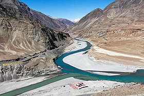
Confluence of Indus and Zanskar rivers. The Indus is at the left of the picture, flowing left-to-right; the Zanskar, carrying more water, comes in from the top of the picture.
 
The Indus river feeds the Indus submarine fan, which is the second largest sediment body on the Earth. It consists of around 5 million cubic kilometres of material eroded from the mountains. Studies of the sediment in the modern river indicate that the Karakoram Mountains in northern Pakistan and India are the single most important source of material, with the Himalayas providing the next largest contribution, mostly via the large rivers of the Punjab (Jhelum, Ravi, Chenab, Beas and Sutlej). Analysis of sediments from the Arabian Sea has demonstrated that prior to five million years ago the Indus was not connected to these Punjab rivers which instead flowed east into the Ganga and were captured after that time. Earlier work showed that sand and silt from western Tibet was reaching the Arabian Sea by 45 million years ago, implying the existence of an ancient Indus River by that time. The delta of this proto-Indus river has subsequently been found in the Katawaz Basin, on the Afghan-Pakistan border. 

In the Nanga Parbat region, the massive amounts of erosion due to the Indus river following the capture and rerouting through that area is thought to bring middle and lower crustal rocks to the surface.

In November 2011, satellite images showed that the Indus river had re-entered India, feeding Great Rann of Kutch, Little Rann of Kutch and a lake near Ahmedabad known as Nal Sarovar. Heavy rains had left the river basin along with the Lake Manchar, Lake Hemal and Kalri Lake (all in modern-day Pakistan) inundated. This happened two centuries after the Indus river shifted its course westwards following the 1819 Rann of Kutch earthquake

The Induan Age at start of the Triassic Period of geological time is named for the Indus region.

Wildlife

Footbridge on the Indus River in Pakistan
 
Fishermen on the Indus River, c. 1905
 
Accounts of the Indus valley from the times of Alexander's campaign indicate a healthy forest cover in the region, which has now considerably receded. The Mughal Emperor Babur writes of encountering rhinoceroses along its bank in his memoirs (the Baburnama). Extensive deforestation and human interference in the ecology of the Shivalik Hills has led to a marked deterioration in vegetation and growing conditions. The Indus valley regions are arid with poor vegetation. Agriculture is sustained largely due to irrigation works. The Indus river and its watershed has a rich biodiversity. It is home to around 25 amphibian species.

Mammals

The Indus river dolphin (Platanista indicus minor) is found only in the Indus River. It is subspecies of the South Asian river dolphin. The Indus river dolphin formerly also occurred in the tributaries of the Indus river. According to the World Wildlife Fund it is one of the most threatened cetaceans with only about 1,000 still existing.

There are two otter species in the Indus River basin: the Eurasian otter in the northeastern highland sections and the smooth-coated otter elsewhere in the river basin. The smooth-coated otters in the Indus River represent a subspecies found nowhere else, the Sindh otter (Lutrogale perspicillata sindica).

Fish

The Indus River basin has a high diversity, being the home of more than 180 freshwater fish species, including 22 which are found nowhere else. Despite declines of several major species, fishing remains an economically important activity in the Indus. Fish also played a major role in earlier cultures of the region, including the ancient Indus Valley Civilisation where depictions of fish were frequent. The Indus script has a commonly used fish sign, which in its various forms may simply have meant "fish", or referred to stars or gods.

In the uppermost, highest part of the Indus River basin there are relatively few genera and species: Diptychus, Ptychobarbus, Schizopyge, Schizopygopsis and Schizothorax snowtrout, Triplophysa loaches, and the catfish Glyptosternon reticulatum. Going downstream these are soon joined by the golden mahseer Tor putitora (alternatively T. macrolepis, although it often is regarded as a synonym of T. putitora) and Schistura loaches. Downriver from around Thakot, Tarbela, the Kabul–Indus river confluence, Attock Khurd and Peshawar the diversity rises strongly, including many cyprinids (Amblypharyngodon, Aspidoparia, Barilius, Chela, Cirrhinus, Crossocheilus, Cyprinion, Danio, Devario, Esomus, Garra, Labeo, Naziritor, Osteobrama, Pethia, Puntius, Rasbora, Salmophasia, Securicula and Systomus), true loaches (Botia and Lepidocephalus), stone loaches (Acanthocobitis and Nemacheilus), ailiid catfish (Clupisoma), bagridae catfish (Batasio, Mystus, Rita and Sperata), airsac catfish (Heteropneustes), schilbid catfish (Eutropiichthys), silurid catfish (Ompok and Wallago), sisorid catfish (Bagarius, Gagata, Glyptothorax and Sisor), gouramis (Trichogaster), nandid leaffish (Nandus), snakeheads (Channa), spiny eel (Macrognathus and Mastacembelus), knifefish (Notopterus), glassfish (Chanda and Parambassis), clupeids (Gudusia), needlefish (Xenentodon) and gobies (Glossogobius), as well as a few introduced species. As the altitude further declines the Indus basin becomes overall quite slow-flowing as it passes through the Punjab Plain. Major carp become common, and chameleonfish (Badis), mullet (Sicamugil) and swamp eel (Monopterus) appear. In some upland lakes and tributaries of the Punjab region snowtrout and mahseer are still common, but once the Indus basin reaches its lower plain the former group is entirely absent and the latter are rare. Many of the species of the middle sections of the Indus basin are also present in the lower. Notable examples of genera that are present in the lower plain but generally not elsewhere in the Indus River basin are the Aphanius pupfish, Aplocheilus killifish, palla fish (Tenualosa ilisha), catla (Labeo catla), rohu (Labeo rohita) and Cirrhinus mrigala. The last four are medium to large species that are important in fisheries and the last three have strongly declined. The lowermost part of the river and its delta are home to freshwater fish, but also a number of brackish and marine species. This includes including pomfret and prawns. The large delta has been recognized by conservationists as an important ecological region. Here, the river turns into many marshes, streams and creeks and meets the sea at shallow levels. 

Palla fish (Tenualosa ilisha) of the river is a delicacy for people living along the river. The population of fish in the river is moderately high, with Sukkur, Thatta, and Kotri being the major fishing centres – all in the lower Sindh course. As a result, damming and irrigation has made fish farming an important economic activity.

Economy

The Indus is the most important supplier of water resources to the Punjab and Sindh plains – it forms the backbone of agriculture and food production in Pakistan. The river is especially critical since rainfall is meagre in the lower Indus valley. Irrigation canals were first built by the people of the Indus Valley Civilisation, and later by the engineers of the Kushan Empire and the Mughal Empire. Modern irrigation was introduced by the British East India Company in 1850 – the construction of modern canals accompanied with the restoration of old canals. The British supervised the construction of one of the most complex irrigation networks in the world. The Guddu Barrage is 1,350 m (4,430 ft) long – irrigating Sukkur, Jacobabad, Larkana and Kalat. The Sukkur Barrage serves over 20,000 km2 (7,700 sq mi). 

After Pakistan came into existence, a water control treaty signed between India and Pakistan in 1960 guaranteed that Pakistan would receive water from the Indus River and its two tributaries the Jhelum River & the Chenab River independently of upstream control by India.

The Indus Basin Project consisted primarily of the construction of two main dams, the Mangla Dam built on the Jhelum River and the Tarbela Dam constructed on the Indus River, together with their subsidiary dams. The Pakistan Water and Power Development Authority undertook the construction of the Chashma-Jhelum link canal – linking the waters of the Indus and Jhelum rivers – extending water supplies to the regions of Bahawalpur and Multan. Pakistan constructed the Tarbela Dam near Rawalpindi – standing 2,743 metres (9,000 ft) long and 143 metres (470 ft) high, with an 80-kilometre (50 mi) long reservoir. It supports the Chashma Barrage near Dera Ismail Khan for irrigation use and flood control and the Taunsa Barrage near Dera Ghazi Khan which also produces 100,000 kilowatts of electricity. The Kotri Barrage near Hyderabad is 915 metres (3,000 ft) long and provides additional water supplies for Karachi. The extensive linking of tributaries with the Indus has helped spread water resources to the valley of Peshawar, in the Khyber Pakhtunkhwa. The extensive irrigation and dam projects provide the basis for Pakistan's large production of crops such as cotton, sugarcane and wheat. The dams also generate electricity for heavy industries and urban centers.

People

The Indus River near Skardu, in Gilgit–Baltistan.
 
The Dubair Khwarr, a tributary of the Indus, near Shaikhdara, in Khyber Pakhtunkhwa.
 
The inhabitants of the regions are mainly Muslim as Pakistan is an Islamic country through which the Indus river passes and forms a major natural feature and resource are diverse in ethnicity, religion, national and linguistic backgrounds. On the northern course of the river in the state of Jammu and Kashmir in India, live the Buddhist people of Ladakh, of Tibetan stock, and the Dards of Indo-Aryan or Dardic stock and practising Islam. Then it descends into Baltistan, northern Pakistan passing the main Balti city of Skardu. A river from Dubair Bala also drains into it at Dubair Bazar. People living in this area are mainly Kohistani and speak the Kohistani language. Major areas through which the Indus river passes in Kohistan are Dasu, Pattan and Dubair. As it continues through Pakistan, the Indus river forms a distinctive boundary of ethnicity and cultures – upon the western banks the population is largely Pashtun, Baloch, and of other Iranian stock. The eastern banks are largely populated by people of Indo-Aryan stock, such as the Punjabis and the Sindhis. In northern Punjab and the Khyber Pakhtunkhwa, ethnic Pashtun tribes live alongside Dardic people in the hills (Khowar, Kalash, Shina, etc.), Burushos (in Hunza), and Punjabi people.

The people living along the Indus river speak Punjabi and Sindhi on the eastern side (in Punjab and Sindh provinces respectively), Pushto plus Balochi as well as Barohi (in Khyber Pakhtoonkha and Baluchistan provinces). In the province of Sindh, the upper third of the river is inhabited by people speaking Saraiki; which is a somewhat transitional dialect of the Punjabi and Sindhi languages.

Modern issues

Satellite images of the upper Indus River valley, comparing water-levels on 1 August 2009 (top) and 31 July 2010 (bottom)
 
The Indus is a strategically vital resource for Pakistan's economy and society. After Pakistan and India declared Independence from the British Raj, the use of the waters of the Indus and its five eastern tributaries became a major dispute between India and Pakistan. The irrigation canals of the Sutlej valley and the Bari Doab were split – with the canals lying primarily in Pakistan and the headwork dams in India disrupting supply in some parts of Pakistan. The concern over India building large dams over various Punjab rivers that could undercut the supply flowing to Pakistan, as well as the possibility that India could divert rivers in the time of war, caused political consternation in Pakistan. Holding diplomatic talks brokered by the World Bank, India and Pakistan signed the Indus Waters Treaty in 1960. The treaty gave India control of the three easternmost rivers of the Punjab, the Sutlej, the Beas and the Ravi, while Pakistan gained control of the three western rivers, the Jhelum, the Chenab and the Indus. India retained the right to use of the western rivers for non-irrigation projects.

Large-scale diversion of the river's water for irrigation has raised far-reaching issues. Sediment clogging from poor maintenance of canals has affected agricultural production and vegetation on numerous occasions. Irrigation itself is increasing soil salinization, reducing crop yields and in some cases rendering farmland useless for cultivation. And ecologically, the reduced flow of fresh water and silt into the Indus delta is threatening the area's mangrove forests.

There are also concerns that the Indus River may be shifting its course westwards, although the progression spans centuries.

Indus delta

Originally, the delta used to receive almost all of the water from the Indus river, which has an annual flow of approximately 180 billion cubic metres (240 billion cubic yards), and is accompanied by 400 million tonnes (390 million long tons) of silt. Since the 1940s, dams, barrages and irrigation works have been constructed on the river Indus. The Indus Basin Irrigation System is the "largest contiguous irrigation system developed over the past 140 years" anywhere in the world. This has reduced the flow of water and by 2018, the average annual flow of water below the Kotri barrage was 33 billion cubic metres (43 billion cubic yards), and annual amount of silt discharged was estimated at 100 million tonnes (98 million long tons). As a result, the 2010 Pakistan floods were considered "good news" for the ecosystem and population of the river delta as they brought much needed fresh water. Any further utilization of the river basin water is not economically feasible.

Vegetation and wildlife of the Indus delta are threatened by the reduced inflow of fresh water, along with extensive deforestation, industrial pollution and global warming. Damming has also isolated the delta population of Indus River dolphins from those further upstream.

Effects of climate change on the river

The Tibetan Plateau contains the world's third-largest store of ice. Qin Dahe, the former head of the China Meteorological Administration, said the recent fast pace of melting and warmer temperatures will be good for agriculture and tourism in the short term, but issued a strong warning:
"Temperatures are rising four times faster than elsewhere in China, and the Tibetan glaciers are retreating at a higher speed than in any other part of the world... In the short term, this will cause lakes to expand and bring floods and mudflows.. In the long run, the glaciers are vital lifelines of the Indus River. Once they vanish, water supplies in Pakistan will be in peril."
"There is insufficient data to say what will happen to the Indus," says David Grey, the World Bank's senior water advisor in South Asia. "But we all have very nasty fears that the flows of the Indus could be severely, severely affected by glacier melt as a consequence of climate change," and reduced by perhaps as much as 50 percent. "Now what does that mean to a population that lives in a desert [where], without the river, there would be no life? I don't know the answer to that question," he says. "But we need to be concerned about that. Deeply, deeply concerned."

U.S. diplomat Richard Holbrooke said, shortly before his death in 2010, that he believed that falling water levels in the Indus River "could very well precipitate World War III."

Pollution

Over the years factories on the banks of the Indus River have increased levels of water pollution in the river and the atmosphere around it. High levels of pollutants in the river have led to the deaths of endangered Indus River Dolphin. The Sindh Environmental Protection Agency has ordered polluting factories around the river to shut down under the Pakistan Environmental Protection Act, 1997. Death of the Indus River Dolphin has also been attributed to fishermen using poison to kill fish and scooping them up. As a result, the government banned fishing from Guddu Barrage to Sukkur.

Coming second after the Yangtze, and together with 9 other rivers, the Indus transports 90 % of all the plastic that reaches the oceans.

2010 floods

Affected areas as of 26 August 2010

Frequently, Indus river is prone to moderate to severe flooding. In July 2010, following abnormally heavy monsoon rains, the Indus River rose above its banks and started flooding. The rain continued for the next two months, devastating large areas of Pakistan. In Sindh, the Indus burst its banks near Sukkur on 8 August, submerging the village of Mor Khan Jatoi. In early August, the heaviest flooding moved southward along the Indus River from severely affected northern regions toward western Punjab, where at least 1,400,000 acres (570,000 ha) of cropland was destroyed, and the southern province of Sindh. As of September 2010, over two thousand people had died and over a million homes had been destroyed since the flooding began.

2011 floods

The 2011 Sindh floods began during the Pakistani monsoon season in mid-August 2011, resulting from heavy monsoon rains in Sindh, eastern Balochistan, and southern Punjab. The floods caused considerable damage; an estimated 434 civilians were killed, with 5.3 million people and 1,524,773 homes affected. Sindh is a fertile region and often called the "breadbasket" of the country; the damage and toll of the floods on the local agrarian economy was said to be extensive. At least 1.7 million acres (690,000 ha; 2,700 sq mi) of arable land were inundated. The flooding followed the previous year's floods, which devastated a large part of the country. Unprecedented torrential monsoon rains caused severe flooding in 16 districts of Sindh.

Barrages, bridges, levees and dams

In Pakistan currently there are three barrages on the Indus: Guddu barrage, Sukkur Barrage, and Kotri barrage (also called Ghulam Muhammad barrage). There are some bridges on river Indus, such as, Dadu Moro Bridge, Larkana Khairpur Indus River Bridge, Thatta-Sujawal bridge, Jhirk-Mula Katiar bridge and recently planned Kandhkot-Ghotki bridge. 

Kala Bagh Barrage, Chasma Barrage, and Taunsa Barrage are also built in Punjab on the Indus.

The entire left bank of Indus river in Sind province is protected from river flooding by constructing around 600 km long levees. The right bank side is also leveed from Guddu barrage to Lake Manchar. In response to the levees construction, the river has been aggrading rapidly over the last 20 years leading to breaches upstream of barrages and inundation of large areas.

Tarbela Dam in Pakistan is constructed on the Indus River, while the controversial Kalabagh dam is also being constructed on Indus river.

Butane

From Wikipedia, the free encyclopedia ...