Search This Blog

Wednesday, January 1, 2020

Atlas V

From Wikipedia, the free encyclopedia
https://en.wikipedia.org/wiki/Atlas_V
 
Atlas V
Atlas V(401) launches with LRO and LCROSS cropped.jpg
Launch of an Atlas V 401 carrying the Lunar Reconnaissance Orbiter and LCROSS space probes on June 18, 2009
FunctionEELV/medium-heavy launch vehicle
ManufacturerUnited Launch Alliance
Country of originUnited States
Cost per launchUS$110 million in 2016
Size
Height58.3 m (191 ft)
Diameter3.81 m (12.5 ft)
Mass590,000 kg (1,300,000 lb)
Stages2
Capacity
Payload to LEO8,250–20,520 kg (18,190–45,240 lb)
Payload to GTO4,750–8,900 kg (10,470–19,620 lb)
Associated rockets
FamilyAtlas (rocket family)
Comparable
Launch history
StatusActive
Launch sitesCape Canaveral SLC-41
Vandenberg SLC-3E
First flight21 August 2002 (Hot Bird 6)
Last flightActive
Notable payloads

Boosters – AJ-60A
No. boosters0 to 5
Length17.0 m (669 in)
Diameter1.6 m (62 in)
Gross mass46,697 kg (102,949 lb)
Propellant mass42,630 kg (93,980 lb) 
Thrust1,688.4 kN (379,600 lbf)
Specific impulse279.3 s (2.739 km/s)
Burn time94 seconds
FuelHTPB
First stage – Atlas CCB
Length32.46 m (106.5 ft)
Diameter3.81 m (12.5 ft)
Empty mass21,054 kg (46,416 lb)
Propellant mass284,089 kg (626,309 lb)
Engines1 RD-180
Thrust3,827 kN (860,000 lbf) (SL)
4,152 kN (933,000 lbf) (vac)
Specific impulse311.3 s (3.053 km/s) (SL)
337.8 s (3.313 km/s) (vac)
Burn time253 seconds
FuelRP-1 / LOX
Second stage – Centaur
Length12.68 m (41.6 ft)
Diameter3.05 m (10.0 ft)
Empty mass2,316 kg (5,106 lb)
Propellant mass20,830 kg (45,920 lb)
Engines1 RL10A or 1 RL10C
Thrust99.2 kN (22,300 lbf) (RL10A)
Specific impulse450.5 s (4.418 km/s) (RL10A-4-2)
Burn time842 seconds (RL10A-4-2)
FuelLH2 / LOX

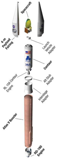
Atlas V is the fifth major version in the Atlas rocket family. It is an expendable launch system originally designed by Lockheed Martin, now being operated by United Launch Alliance (ULA), a joint venture between Lockheed and Boeing.

Each Atlas V rocket consists of two main stages. The first stage is powered by a Russian RD-180 engine manufactured by RD Amross and burning kerosene and liquid oxygen. The Centaur upper stage is powered by one or two US RL10 engine(s) manufactured by Aerojet Rocketdyne and burning liquid hydrogen and liquid oxygen. AJ-60A strap-on solid rocket boosters (SRBs) are used in some configurations and will be replaced by GEM-63 SRBs in the near future. The standard payload fairings are 4 or 5 meters in diameter with various lengths.

Vehicle description

The Atlas V was developed by Lockheed Martin Commercial Launch Services (LM CLS) as part of the US Air Force Evolved Expendable Launch Vehicle (EELV) program and made its inaugural flight on August 21, 2002. The vehicle operates out of Space Launch Complex 41 at Cape Canaveral Air Force Station and Space Launch Complex 3-E at Vandenberg Air Force Base. LM CLS continued to market the Atlas V to commercial customers worldwide until January 2018, when ULA assumed control of commercial marketing and sales.

Atlas V first stage

The Atlas V first stage, the Common Core Booster (CCB), is 12.5 ft (3.8 m) in diameter and 106.6 ft (32.5 m) in length. It is powered by a single Russian RD-180 main engine burning 627,105 lb (284,450 kg) of liquid oxygen and RP-1. The booster operates for about four minutes, providing about 4 meganewtons (860,000 lbf) of thrust. Thrust can be augmented with up to five Aerojet strap-on solid rocket boosters, each providing an additional 1.27 meganewtons (285,500 lbf) of thrust for 94 seconds. 

The Atlas V is the newest member of the Atlas family. Compared to the Atlas III vehicle, there are numerous changes. Compared to the Atlas II, the first stage is a near-redesign. There was no Atlas IV.
The main differences between the Atlas V and earlier Atlas I and II family rockets are:
  • The first stage tanks no longer use stainless-steel monocoque pressure stabilized "balloon" construction. The tanks are isogrid aluminum and are structurally stable when unpressurized.
  • Use of aluminum, with a higher thermal conductivity than stainless steel, requires insulation for the liquid oxygen. The tanks are covered in a polyurethane-based layer.
  • Accommodation points for parallel stages, both smaller solids and identical liquids, are built into first-stage structures.
  • The "1.5 staging" technique is no longer used, having been discontinued on the Atlas III with the introduction of the Russian RD-180 engine. The RD-180 features a single turbopump feeding dual combustion chambers and nozzles burning kerosene/liquid oxygen propellants.
  • As with the Atlas III, the oxygen tank is larger relative to the fuel tank to accommodate the mixture ratio of the RD-180.
  • The main-stage diameter increased from 10 feet to 12.5 feet.

Centaur upper stage

The Centaur upper stage uses a pressure-stabilized propellant-tank design and cryogenic propellants. The Centaur stage for Atlas V is stretched 5.5 ft (1.68 m) relative to the Atlas IIAS Centaur and is powered by either one or two Aerojet Rocketdyne RL10A-4-2 engines, each engine developing a thrust of 99.2 kN (22,300 lbf). The inertial navigation unit (INU) located on the Centaur provides guidance and navigation for both the Atlas and Centaur and controls both Atlas and Centaur tank pressures and propellant use. The Centaur engines are capable of multiple in-space starts, making possible insertion into low Earth parking orbit, followed by a coast period and then insertion into GTO. A subsequent third burn following a multi-hour coast can permit direct injection of payloads into geostationary orbit. As of 2006, the Centaur vehicle had the highest proportion of burnable propellant relative to total mass of any modern hydrogen upper stage and hence can deliver substantial payloads to a high-energy state.

Payload fairing

Atlas V payload fairings are available in two diameters, depending on satellite requirements. The 4.2 meter diameter fairing, originally designed for the Atlas II booster, comes in three different lengths: the original 9-meter-long version and extended 10-meter and 11-meter versions, first flown respectively on the AV-008/Astra 1KR and AV-004/Inmarsat-4 F1 missions. Fairings of up to 7.2 m diameter and 32.3 m length have been considered but were never implemented.

A 5.4 meter diameter fairing (4.57 meters internally usable) was developed and built by RUAG Space in Switzerland. The RUAG fairing uses carbon fiber composite construction and is based on a similar flight-proven fairing for the Ariane 5. Three configurations are manufactured to support the Atlas V: 20.7 m, 23.4 m, and 26.5 meters long. While the classic 4-meter fairing covers only the payload, the RUAG fairing is much longer and fully encloses both the Centaur upper stage and the payload.

Upgrades

Many systems on the Atlas V have been the subject of upgrade and enhancement both prior to the first Atlas V flight and since that time. Work on a new Fault Tolerant Inertial Navigation Unit (FTINU) started in 2001 to enhance mission reliability for Atlas vehicles by replacing the existing non-redundant navigation and computing equipment with a fault-tolerant unit. The upgraded FTINU first flew in 2006, and in 2010 a follow-on order for more FTINU units was awarded. Later in the decade, the FTINU was replaced with avionics common to both the Atlas V and Delta IV.

Human-rating

Proposals and design work to human-rate the Atlas V began as early as 2006, with ULA's parent company Lockheed Martin reporting an agreement with Bigelow Aerospace that was intended to lead to commercial private trips to low Earth orbit (LEO).

Human-rating design and simulation work began in earnest in 2010, with the award of US$6,700,000 in the first phase of the NASA Commercial Crew Program (CCP) to develop an Emergency Detection System (EDS). As of February 2011, ULA had received an extension to April 2011 from NASA and was finishing up work on the EDS.

NASA solicited proposals for CCP phase 2 in October 2010, and ULA proposed to complete design work on the EDS. At the time, NASA's goal was to get astronauts to orbit by 2015. Then-ULA President and CEO Michael Gass stated that a schedule acceleration to 2014 was possible if funded. Other than the addition of the Emergency Detection System, no major changes were expected to the Atlas V rocket, but ground infrastructure modifications were planned. The most likely candidate for the human-rating was the N02 configuration, with no fairing, no solid rocket boosters, and dual RL10 engines on the Centaur upper stage.

On 18 July 2011, NASA and ULA announced an agreement on the possibility of certifying the Atlas V to NASA's standards for human spaceflight. ULA agreed to provide NASA with data on the Atlas V, while NASA would provide ULA with draft human certification requirements. In 2011, the human-rated Atlas V was also still under consideration to carry spaceflight participants to the proposed Bigelow Commercial Space Station.

In 2011, Sierra Nevada Corporation (SNC) picked the Atlas V to be the booster for its still-under-development Dream Chaser crewed spaceplane. The Dream Chaser was intended to launch on an Atlas V, fly a crew to the ISS, and landing horizontally following a lifting-body reentry. However, in late 2014 NASA did not select the Dream Chaser to be one of the two vehicles selected under the Commercial Crew competition.

On 4 August 2011, Boeing announced that it would use the Atlas V as the initial launch vehicle for its CST-100 crew capsule. CST-100 will take NASA astronauts to the International Space Station and was also intended to service the proposed Bigelow Commercial Space Station. A three-flight test program was projected to be completed by 2015, certifying the Atlas V/CST-100 combination for human spaceflight operations. The first flight was expected to include an Atlas V rocket integrated with an uncrewed CST-100 capsule, the second flight an in-flight launch abort system demonstration in the middle of that year, and the third flight a crewed mission carrying two Boeing test-pilot astronauts into LEO and returning them safely at the end of 2015. These plans did not materialize. 

In 2014, NASA selected the Boeing CST-100 space capsule as part of the CCD program after extensive delays. Atlas V is the launch vehicle of the CST-100. The first launch of an uncrewed CST-100 capsule occurred atop a human-rated Atlas V on the morning of December 20, 2019, however an anomaly with the Mission Elapsed Time clock aboard the CST-100 caused the spacecraft to enter a suboptimal orbit. As a result, the CST-100 could not achieve orbital insertion to reach the International Space Station, and will instead be deorbited after two days.

New solid boosters

In 2015, ULA announced that the Aerojet Rocketdyne-produced AJ-60A solid rocket boosters (SRBs) currently in use on Atlas V will be superseded by new GEM 63 boosters produced by Orbital ATK. The extended GEM-63XL boosters will also be used on the Vulcan rocket that will replace the Atlas V.

Versions

Atlas V family with asymmetric SRBs. The HLV was not developed
 
Atlas V 401
 
Each Atlas V booster configuration has a three-digit designation. The first digit shows the diameter (in meters) of the payload fairing and has a value of "4" or "5" for fairing launches and "N" for crew capsule launches (as no payload fairing is used when a crew capsule is launched). The second digit indicates the number of solid rocket boosters (SRBs) attached to the base of the rocket and can range from "0" through "3" with the 4-meter fairing, and "0" through "5" with the 5-meter fairing. As seen in the first image, all SRB layouts are asymmetrical. The third digit represents the number of engines on the Centaur stage, either "1" or "2". 

For example, an Atlas V 551 has a 5-meter fairing, 5 SRBs, and 1 Centaur engine, whereas an Atlas V 431 has a 4-meter fairing, 3 SRBs, and 1 Centaur engine. The crewed Atlas V N22 with no fairing, two SRBs, and 2 Centaur engines is currently intended for launch in 2019. The flight will carry the Starliner vehicle for its first orbital test flight

As of June 2015, all versions of the Atlas V, its design and production rights, and intellectual property rights are owned by ULA and Lockheed Martin.

Capabilities

List date: August 8, 2019 Mass to LEO numbers are at an inclination of 28.5°. Acronyms: Single Engine Centaur (SEC), Dual Engine Centaur (DEC).

Geology of Mars (updated)

From Wikipedia, the free encyclopedia
 
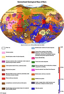
Generalised geological map of Mars
 
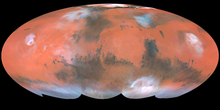
Mars as seen by the Hubble Space Telescope
 
The geology of Mars is the scientific study of the surface, crust, and interior of the planet Mars. It emphasizes the composition, structure, history, and physical processes that shape the planet. It is analogous to the field of terrestrial geology. In planetary science, the term geology is used in its broadest sense to mean the study of the solid parts of planets and moons. The term incorporates aspects of geophysics, geochemistry, mineralogy, geodesy, and cartography. A neologism, areology, from the Greek word Arēs (Mars), sometimes appears as a synonym for Mars's geology in the popular media and works of science fiction (e.g. Kim Stanley Robinson's Mars trilogy).

Geological map of Mars (2014)

Mars - geologic map (USGS; July 14, 2014) (full image)
 

Composition of Mars

Mars is a differentiated, terrestrial planet. The InSight lander mission is designed to study the deep interior of Mars. The mission landed on 26 November 2018, and will deploy a sensitive seismometer that will enable 3D structure maps of the deep interior. 

Global physiography

Most of our current knowledge about the geology of Mars comes from studying landforms and relief features (terrain) seen in images taken by orbiting spacecraft. Mars has a number of distinct, large-scale surface features that indicate the types of geological processes that have operated on the planet over time. This section introduces several of the larger physiographic regions of Mars. Together, these regions illustrate how geologic processes involving volcanism, tectonism, water, ice, and impacts have shaped the planet on a global scale. 

Hemispheric dichotomy

Mars Orbital Laser Altimeter (MOLA) colorized shaded-relief maps showing elevations in the western and eastern hemispheres of Mars. (Left): The western hemisphere is dominated by the Tharsis region (red and brown). Tall volcanoes appear white. Valles Marineris (blue) is the long gash-like feature to the right. (Right): Eastern hemisphere shows the cratered highlands (yellow to red) with the Hellas basin (deep blue/purple) at lower left. The Elysium province is at the upper right edge. Areas north of the dichotomy boundary appear as shades of blue on both maps.
 
The northern and southern hemispheres of Mars are strikingly different from each other in topography and physiography. This dichotomy is a fundamental global geologic feature of the planet. Simply stated, the northern part of the planet is an enormous topographic depression. About one-third of the planet's surface (mostly in the northern hemisphere) lies 3–6 km lower in elevation than the southern two-thirds. This is a first-order relief feature on par with the elevation difference between Earth's continents and ocean basins. The dichotomy is also expressed in two other ways: as a difference in impact crater density and crustal thickness between the two hemispheres. The hemisphere south of the dichotomy boundary (often called the southern highlands or uplands) is very heavily cratered and ancient, characterized by rugged surfaces that date back to the period of heavy bombardment. In contrast, the lowlands north of the dichotomy boundary have few large craters, are very smooth and flat, and have other features indicating that extensive resurfacing has occurred since the southern highlands formed. The third distinction between the two hemispheres is in crustal thickness. Topographic and geophysical gravity data indicate that the crust in the southern highlands has a maximum thickness of about 58 km (36 mi), whereas crust in the northern lowlands "peaks" at around 32 km (20 mi) in thickness. The location of the dichotomy boundary varies in latitude across Mars and depends on which of the three physical expressions of the dichotomy is being considered. 

The origin and age of the hemispheric dichotomy are still debated. Hypotheses of origin generally fall into two categories: one, the dichotomy was produced by a mega-impact event or several large impacts early in the planet's history (exogenic theories) or two, the dichotomy was produced by crustal thinning in the northern hemisphere by mantle convection, overturning, or other chemical and thermal processes in the planet's interior (endogenic theories). One endogenic model proposes an early episode of plate tectonics producing a thinner crust in the north, similar to what is occurring at spreading plate boundaries on Earth. Whatever its origin, the Martian dichotomy appears to be extremely old. A new theory based on the Southern Polar Giant Impact and validated by the discovery of twelve hemispherical alignments shows that exogenic theories appear to be stronger than endogenic theories and that Mars never had plate tectonics that could modify the dichotomy. Laser altimeter and radar sounding data from orbiting spacecraft have identified a large number of basin-sized structures previously hidden in visual images. Called quasi-circular depressions (QCDs), these features likely represent derelict impact craters from the period of heavy bombardment that are now covered by a veneer of younger deposits. Crater counting studies of QCDs suggest that the underlying surface in the northern hemisphere is at least as old as the oldest exposed crust in the southern highlands. The ancient age of the dichotomy places a significant constraint on theories of its origin.

Tharsis and Elysium volcanic provinces

Straddling the dichotomy boundary in Mars's western hemisphere is a massive volcano-tectonic province known as the Tharsis region or the Tharsis bulge. This immense, elevated structure is thousands of kilometers in diameter and covers up to 25% of the planet's surface.[25] Averaging 7–10 km above datum (Martian "sea" level), Tharsis contains the highest elevations on the planet and the largest known volcanoes in the Solar System. Three enormous volcanoes, Ascraeus Mons, Pavonis Mons, and Arsia Mons (collectively known as the Tharsis Montes), sit aligned NE-SW along the crest of the bulge. The vast Alba Mons (formerly Alba Patera) occupies the northern part of the region. The huge shield volcano Olympus Mons lies off the main bulge, at the western edge of the province. The extreme massiveness of Tharsis has placed tremendous stresses on the planet's lithosphere. As a result, immense extensional fractures (grabens and rift valleys) radiate outward from Tharsis, extending halfway around the planet.

A smaller volcanic center lies several thousand kilometers west of Tharsis in Elysium. The Elysium volcanic complex is about 2,000 kilometers in diameter and consists of three main volcanoes, Elysium Mons, Hecates Tholus, and Albor Tholus. The Elysium group of volcanoes is thought to be somewhat different from the Tharsis Montes, in that development of the former involved both lavas and pyroclastics.

Large impact basins

Several enormous, circular impact basins are present on Mars. The largest one that is readily visible is the Hellas basin located in the southern hemisphere. It is the second largest confirmed impact structure on the planet, centered at about 64°E longitude and 40°S latitude. The central part of the basin (Hellas Planitia) is 1,800 km in diameter and surrounded by a broad, heavily eroded annular rim structure characterized by closely spaced rugged irregular mountains (massifs), which probably represent uplifted, jostled blocks of old pre-basin crust. Ancient, low-relief volcanic constructs (highland paterae) are located on the northeastern and southwestern portions of the rim. The basin floor contains thick, structurally complex sedimentary deposits that have a long geologic history of deposition, erosion, and internal deformation. The lowest elevations on the planet are located within the Hellas basin, with some areas of the basin floor lying over 8 km below datum.

The two other large impact structures on the planet are the Argyre and Isidis basins. Like Hellas, Argyre (800 km in diameter) is located in the southern highlands and is surrounded by a broad ring of mountains. The mountains in the southern portion of the rim, Charitum Montes, may have been eroded by valley glaciers and ice sheets at some point in Mars's history. The Isidis basin (roughly 1,000 km in diameter) lies on the dichotomy boundary at about 87°E longitude. The northeastern portion of the basin rim has been eroded and is now buried by northern plains deposits, giving the basin a semicircular outline. The northwestern rim of the basin is characterized by arcuate grabens (Nili Fossae) that are circumferential to the basin. One additional large basin, Utopia, is completely buried by northern plains deposits. Its outline is clearly discernable only from altimetry data. All of the large basins on Mars are extremely old, dating back to the late heavy bombardment. They are thought to be comparable in age to the Imbrium and Orientale basins on the Moon.

Equatorial canyon system

Viking Orbiter 1 view image of Valles Marineris.
 
Near the equator in the western hemisphere lies an immense system of deep, interconnected canyons and troughs collectively known as the Valles Marineris. The canyon system extends eastward from Tharsis for a length of over 4,000 km, nearly a quarter of the planet's circumference. If placed on Earth, Valles Marineris would span the width of North America. In places, the canyons are up to 300 km wide and 10 km deep. Often compared to Earth's Grand Canyon, the Valles Marineris has a very different origin than its tinier, so-called counterpart on Earth. The Grand Canyon is largely a product of water erosion. The Martian equatorial canyons were of tectonic origin, i.e. they were formed mostly by faulting. They could be similar to the East African Rift valleys. The canyons represent the surface expression of powerful extensional strain in the Martian crust, probably due to loading from the Tharsis bulge.

Chaotic terrain and outflow channels

The terrain at the eastern end of the Valles Marineris grades into dense jumbles of low rounded hills that seem to have formed by the collapse of upland surfaces to form broad, rubble-filled hollows. Called chaotic terrain, these areas mark the heads of huge outflow channels that emerge full size from the chaotic terrain and empty (debouch) northward into Chryse Planitia. The presence of streamlined islands and other geomorphic features indicate that the channels were most likely formed by catastrophic releases of water from aquifers or the melting of subsurface ice. However, these features could also be formed by abundant volcanic lava flows coming from Tharsis. The channels, which include Ares, Shalbatana, Simud, and Tiu Valles, are enormous by terrestrial standards, and the flows that formed them correspondingly immense. For example, the peak discharge required to carve the 28-km-wide Ares Vallis is estimated to have been 14 million cubic metres (500 million cu ft) per second, over ten thousand times the average discharge of the Mississippi River.

Mars Orbital Laser Altimeter (MOLA) derived image of Planum Boreum. Vertical exaggeration is extreme. Note that residual ice cap is only the thin veneer (shown in white) on top of the plateau.
 

Ice caps

The polar ice caps are well-known telescopic features of Mars, first identified by Christiaan Huygens in 1672. Since the 1960s, we have known that the seasonal caps (those seen in the telescope to grow and wane seasonally) are composed of carbon dioxide (CO2) ice that condenses out of the atmosphere as temperatures fall to 148 K, the frost point of CO2, during the polar wintertime. In the north, the CO2 ice completely dissipates (sublimes) in summer, leaving behind a residual cap of water (H2O) ice. At the south pole, a small residual cap of CO2 ice remains in summer. 

Both residual ice caps overlie thick layered deposits of interbedded ice and dust. In the north, the layered deposits form a 3 km-high, 1,000 km-diameter plateau called Planum Boreum. A similar kilometers-thick plateau, Planum Australe, lies in the south. Both plana (the Latin plural of planum) are sometimes treated as synonymous with the polar ice caps, but the permanent ice (seen as the high albedo, white surfaces in images) forms only a relatively thin mantle on top of the layered deposits. The layered deposits probably represent alternating cycles of dust and ice deposition caused by climate changes related to variations in the planet's orbital parameters over time. The polar layered deposits are some of the youngest geologic units on Mars. 

Geological history

Albedo features

Mollweide projection of albedo features on Mars from Hubble Space Telescope. Bright ochre areas in left, center, and right are Tharsis, Arabia, and Elysium, respectively. The dark region at top center left is Acidalium Planitia. Syrtis Major is the dark area projecting upward in the center right. Note orographic clouds over Olympus and Elysium Montes (left and right, respectively).

No topography is visible on Mars from Earth. The bright areas and dark markings seen through a telescope are albedo features. The bright, red-ochre areas are locations where fine dust covers the surface. Bright areas (excluding the polar caps and clouds) include Hellas, Tharsis, and Arabia Terra. The dark gray markings represent areas that the wind has swept clean of dust, leaving behind the lower layer of dark, rocky material. Dark markings are most distinct in a broad belt from 0° to 40° S latitude. However, the most prominent dark marking, Syrtis Major Planum, is in the northern hemisphere. The classical albedo feature, Mare Acidalium (Acidalia Planitia), is another prominent dark area in the northern hemisphere. A third type of area, intermediate in color and albedo, is also present and thought to represent regions containing a mixture of the material from the bright and dark areas.

Impact craters

Impact craters were first identified on Mars by the Mariner 4 spacecraft in 1965. Early observations showed that Martian craters were generally shallower and smoother than lunar craters, indicating that Mars has a more active history of erosion and deposition than the Moon.

In other aspects, Martian craters resemble lunar craters. Both are products of hypervelocity impacts and show a progression of morphology types with increasing size. Martian craters below about 7 km in diameter are called simple craters; they are bowl-shaped with sharp raised rims and have depth/diameter ratios of about 1/5. Martian craters change from simple to more complex types at diameters of roughly 5 to 8 km. Complex craters have central peaks (or peak complexes), relatively flat floors, and terracing or slumping along the inner walls. Complex craters are shallower than simple craters in proportion to their widths, with depth/diameter ratios ranging from 1/5 at the simple-to-complex transition diameter (~7 km) to about 1/30 for a 100-km diameter crater. Another transition occurs at crater diameters of around 130 km as central peaks turn into concentric rings of hills to form multi-ring basins.

Mars has the greatest diversity of impact crater types of any planet in the Solar System. This is partly because the presence of both rocky and volatile-rich layers in the subsurface produces a range of morphologies even among craters within the same size classes. Mars also has an atmosphere that plays a role in ejecta emplacement and subsequent erosion. Moreover, Mars has a rate of volcanic and tectonic activity low enough that ancient, eroded craters are still preserved, yet high enough to have resurfaced large areas of the planet, producing a diverse range of crater populations of widely differing ages. Over 42,000 impact craters greater than 5 km in diameter have been catalogued on Mars, and the number of smaller craters is probably innumerable. The density of craters on Mars is highest in the southern hemisphere, south of the dichotomy boundary. This is where most of the large craters and basins are located.

Crater morphology provides information about the physical structure and composition of the surface and subsurface at the time of impact. For example, the size of central peaks in Martian craters is larger than comparable craters on Mercury or the Moon. In addition, the central peaks of many large craters on Mars have pit craters at their summits. Central pit craters are rare on the Moon but are very common on Mars and the icy satellites of the outer Solar System. Large central peaks and the abundance of pit craters probably indicate the presence of near-surface ice at the time of impact. Polewards of 30 degrees of latitude, the form of older impact craters is rounded out ("softened") by acceleration of soil creep by ground ice.

The most notable difference between Martian craters and other craters in the Solar System is the presence of lobate (fludized) ejecta blankets. Many craters at equatorial and mid-latitudes on Mars have this form of ejecta morphology, which is thought to arise when the impacting object melts ice in the subsurface. Liquid water in the ejected material forms a muddy slurry that flows along the surface, producing the characteristic lobe shapes. The crater Yuty is a good example of a rampart crater, which is so called because of the rampart-like edge to its ejecta blanket.

Martian craters are commonly classified by their ejecta. Craters with one ejecta layer are called single-layer ejecta (SLE) craters. Craters with two superposed ejecta blankets are called double-layer ejecta (DLE) craters, and craters with more than two ejecta layers are called multiple-layered ejecta (MLE) craters. These morphological differences are thought to reflect compositional differences (i.e. interlayered ice, rock, or water) in the subsurface at the time of impact.

Pedestal crater in Amazonis quadrangle as seen by HiRISE.
 
Martian craters show a large diversity of preservational states, from extremely fresh to old and eroded. Degraded and infilled impact craters record variations in volcanic, fluvial, and eolian activity over geologic time. Pedestal craters are craters with their ejecta sitting above the surrounding terrain to form raised platforms. They occur because the crater's ejecta forms a resistant layer so that the area nearest the crater erodes more slowly than the rest of the region. Some pedestals are hundreds of meters above the surrounding area, meaning that hundreds of meters of material were eroded away. Pedestal craters were first observed during the Mariner 9 mission in 1972.

Volcanism

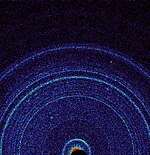
First X-ray diffraction view of Martian soil - CheMin analysis reveals feldspar, pyroxenes, olivine and more (Curiosity rover at "Rocknest", October 17, 2012).
 
Volcanic structures and landforms cover large portions of the Martian surface. The most conspicuous volcanoes on Mars are located in Tharsis and Elysium. Geologists think one of the reasons volcanoes on Mars were able to grow so large is that Mars has fewer tectonic boundaries in comparison to Earth. Lava from a stationary hot spot was able to accumulate at one location on the surface for many hundreds of millions of years.

Scientists have never recorded an active volcano eruption on the surface of Mars. Searches for thermal signatures and surface changes within the last decade have not yielded evidence for active volcanism.

On October 17, 2012, the Curiosity rover on the planet Mars at "Rocknest" performed the first X-ray diffraction analysis of Martian soil. The results from the rover's CheMin analyzer revealed the presence of several minerals, including feldspar, pyroxenes and olivine, and suggested that the Martian soil in the sample was similar to the "weathered basaltic soils" of Hawaiian volcanoes. In July 2015, the same rover identified tridymite in a rock sample from Gale Crater, leading scientists to conclude that silicic volcanism might have played a much more prevalent role in the planet's volcanic history than previously thought.

Sedimentology

Collection of spheres, each about 3 mm in diameter as seen by Opportunity rover
 
Flowing water appears to have been common on the surface of Mars at various points in its history, and especially on ancient Mars. Many of these flows carved the surface, forming valley networks and producing sediment. This sediment has been redeposited in a wide variety of wet environments, including in alluvial fans, meandering channels, deltas, lakes, and perhaps even oceans. The processes of deposition and transportation are associated with gravity. Due to gravity, related differences in water fluxes and flow speeds, inferred from grain size distributions, Martian landscapes were created by different environmental conditions. Nevertheless, there are other ways of estimating the amount of water on ancient Mars. Groundwater has been implicated in the cementation of aeolian sediments and the formation and transport of a wide variety of sedimentary minerals including clays, sulphates and hematite.

When the surface has been dry, wind has been a major geomorphic agent. Wind driven sand bodies like megaripples and dunes are extremely common on the modern Martian surface, and Opportunity has documented abundant aeolian sandstones on its traverse. Ventifacts, like Jake Matijevic (rock), are another aeolian landform on the Martian Surface.

A wide variety of other sedimentological facies are also present locally on Mars, including glacial deposits, hot springs, dry mass movement deposits (especially landslides), and cryogenic and periglacial material, amongst many others. Evidence for ancient rivers, a lake, and dune fields have all been observed in the preserved strata by rovers at Meridiani Planum and Gale crater. 

Common surface features

Groundwater on Mars

One group of researchers proposed that some of the layers on Mars were caused by groundwater rising to the surface in many places, especially inside of craters. According to the theory, groundwater with dissolved minerals came to the surface, in and later around craters, and helped to form layers by adding minerals (especially sulfate) and cementing sediments. This hypothesis is supported by a groundwater model and by sulfates discovered in a wide area. At first, by examining surface materials with Opportunity Rover, scientists discovered that groundwater had repeatedly risen and deposited sulfates. Later studies with instruments on board the Mars Reconnaissance Orbiter showed that the same kinds of materials exist in a large area that included Arabia.

Interesting geomorphological features


Avalanches

On February 19, 2008, images obtained by the HiRISE camera on the Mars Reconnaissance Orbiter showed a spectacular avalanche, in which debris thought to be fine-grained ice, dust, and large blocks fell from a 700-metre (2,300 ft) high cliff. Evidence of the avalanche included dust clouds rising from the cliff afterwards. Such geological events are theorized to be the cause of geologic patterns known as slope streaks.

Possible caves

NASA scientists studying pictures from the Odyssey spacecraft have spotted what might be seven caves on the flanks of the Arsia Mons volcano on Mars. The pit entrances measure from 100 to 252 metres (328 to 827 ft) wide and they are thought to be at least 73 to 96 metres (240 to 315 ft) deep. See image below: the pits have been informally named (A) Dena, (B) Chloe, (C) Wendy, (D) Annie, (E) Abby (left) and Nikki, and (F) Jeanne. Dena's floor was observed and found to be 130 m deep. Further investigation suggested that these were not necessarily lava tube "skylights". Review of the images has resulted in yet more discoveries of deep pits.

It has been suggested that human explorers on Mars could use lava tubes as shelters. The caves may be the only natural structures offering protection from the micrometeoroids, UV radiation, solar flares, and high energy particles that bombard the planet's surface. These features may enhance preservation of biosignatures over long periods of time and make caves an attractive astrobiology target in the search for evidence of life beyond Earth. 

Inverted relief

Some areas of Mars show inverted relief, where features that were once depressions, like streams, are now above the surface. It is believed that materials like large rocks were deposited in low-lying areas. Later, wind erosion removed much of the surface layers, but left behind the more resistant deposits. Other ways of making inverted relief might be lava flowing down a stream bed or materials being cemented by minerals dissolved in water. On Earth, materials cemented by silica are highly resistant to all kinds of erosional forces. Examples of inverted channels on Earth are found in the Cedar Mountain Formation near Green River, Utah. Inverted relief in the shape of streams are further evidence of water flowing on the Martian surface in past times. Inverted relief in the form of stream channels suggest that the climate was different—much wetter—when the inverted channels were formed. 

In an article published in January 2010, a large group of scientists endorsed the idea of searching for life in Miyamoto Crater because of inverted stream channels and minerals that indicated the past presence of water.

Pope Pius XII and Judaism

From Wikipedia, the free encyclopedia
https://en.wikipedia.org/wiki/Pope_Pius_XII_and_Judaism

The relations between Pope Pius XII and Judaism have long been controversial, especially those questions that surround Pope Pius XII and the Holocaust. Other issues involve Pius's Jewish friendships and his attitude towards the new state of Israel.

1917 intervention in Palestine

Documents discovered in the Vatican archives by Michael Hesemann indicate that Archbishop Pacelli intervened in 1917, through the German government, to assure the Jews of Palestine that they would be protected from any harm from the Ottoman Turks. Hesemann further stated that Pacelli also directly intervened with the World Zionist Organization representative Nachum Sokolov, and used his influence to arrange for Mr. Sokolov to meet directly with the Benedict XV in 1917 to discuss a Jewish homeland in Palestine. In 1926, Pacelli also encouraged Catholics in Germany to join the Committee Pro Palestina, which supported Jewish settlements in Palestine.

1938 Eucharistic conference

An International Eucharistic Conference took place in Budapest in Hungary during 1938. Cardinal Pacelli used the opportunity to denounce "the lugubrious array of the militant godless, shaking the clenched fist of anti-Christ." He added: "Where now are Herod and Pilate, Nero and Diocletian, and Julian the Apostate, and all the persecutors of the First Century? St. Ambrose replies: ‘The Christians who have been massacred have won the victory; the vanquished were their persecutors.'"

According to a contemporary translation into Hungarian of a second quote from Pacelli's discourse, which was originally delivered in French, Pacelli also stated: "As opposed to the foes of Jesus, who cried out to his face, 'Crucify him!' we sing him hymns of our loyalty and our love. We act in this fashion, not out of bitterness, not out of a sense of superiority, not out of arrogance toward those whose lips curse him and whose hearts reject him even today."

This second quote, which was published in a Hungarian newspaper, has been used by some commentators to imply that Pacelli was making an anti-semitic remark, despite his words including non-Jews (such as the Roman emperors and Pontius Pilate) in the speech. This claim is disputed by those who have access to the original and complete French text, such as Fr. Peter Gumpel, law professor Ronald J. Rychlak, and historian William Doino, Jr., who state that the context indicates that it was an attack on the mass political movements of the day, and was particularly applicable to fascism.

Attitude during the Holocaust

Cardinal Secretary of State Luigi Maglione received a request from Chief Rabbi of Palestine Isaac Herzog in the Spring of 1940 to intercede on behalf of Lithuanian Jews about to be deported to Germany. Pius called Ribbentrop on March 11, repeatedly protesting against the treatment of Jews. In his 1940 encyclical Summi Pontificatus, Pius rejected anti-semitism, stating that in the Catholic Church there is "neither Gentile nor Jew, circumcision nor uncircumcision." In the summer of 1942, Pius explained to his college of Cardinals the reasons for the great gulf that existed between Jews and Christians at the theological level: "Jerusalem has responded to His call and to His grace with the same rigid blindness and stubborn ingratitude that has led it along the path of guilt to the murder of God." Historian Guido Knopp describes these comments of Pius as being "incomprehensible" at a time when "Jerusalem was being murdered by the million". In revising his previous opinion Michael Phayer asserts that Pius did speak out against the holocaust in his 1942 Christmas message.

Biblical issues

The encyclical, Divino afflante Spiritu, published in September 1943 emphasized the role of the Bible. He encouraged Christian theologians to revisit original versions of the Bible in Greek and Hebrew. Noting improvements in archaeology, the encyclical reversed Pope Leo XIII's encyclical, which had only advocated going back to the original texts to resolve ambiguity in the Latin Vulgate. The encyclical demands a much better understanding of ancient Jewish history and traditions. It requires bishops throughout the Church to initiate biblical studies for lay people. The Pontiff also requests a reorientation of Catholic teaching and education, relying much more on sacred scriptures in sermons and religious instruction.

Relations with Israel

In multiplicibus curis is a peace encyclical of Pope Pius XII focusing on the war in Palestine. It was given at Castel Gandolfo, near Rome, October 24, 1948, the tenth year of his Pontificate.

When war was declared, the Pope maintained the attitude of impartiality but also looked for possibilities for justice and peace in Palestine and for the respect and protection of the Holy Places. Pope Pius organized charities for the refugees and victims of the war, fully recognizing that this would not be sufficient.

Pius also made a proposal for Jerusalem to become an international city, either under the United Nations or a related organization. The idea first appeared in the 1949 encyclical Redemptoris nostri cruciatus. It was later re-proposed during the papacies of John XXIII, Paul VI and John Paul II.

Friendly relationship with Guido Mendes

In 1958, Dr. Guido Mendes wrote an article in the Jerusalem Post explaining how he had been friends with Pope Pacelli since his youth. He said that the Pope had discussed Jewish theology and participated in a Sabbath with important members of the Roman Jewish community. They exchanged ideals and future prospects, with Pacelli later expressing enthusiasm for the new State of Israel.

Conversion of rabbi Israel Zolli

According to biographer Judith Cabaud, in 1944, while conducting a Yom Kippur service, the Chief Rabbi of Rome, Israel Zolli experienced a mystical vision about Jesus Christ. Shortly after the end of World War II, Rabbi Zolli and his second wife (his first wife had died years before) were received into the Roman Catholic Church. 

Zolli then went to the Gregorian University. He was baptized by Mgr. Luigi Traglia in the presence of Father Dezza, also known as Paolo Cardinal Dezza. Israel Zolli was named Eugenio Maria Zolli in honor of Pope Pius XII, who was born Eugenio Pacelli.

Council of Christians and Jews

The Council of Christians and Jews is a voluntary organisation in the United Kingdom and is composed of Christians and Jews working together to counter anti-semitism and other forms of intolerance in Britain. In late 1954, and reflecting the theology of the era, the Vatican instructed the head of English Catholics to resign from the council due to its perceived indifferentism, with Catholics not returning until the reforms introduced by the Second Vatican Council.

Good Friday Prayer for the Jews

Kneeling had always accompanied the other petitions in the Holy Week liturgy. In 1955, Pope Pius XII re-instituted kneeling for this petition (the prayer for the Jews). 

The English translation of the prayer read:
Let us pray also for the faithless Jews: that almighty God may remove the veil from their hearts; so that they too may acknowledge Jesus Christ our Lord. Let us pray. Let us kneel. [pause for silent prayer] Arise. Almighty and eternal God, who dost not exclude from thy mercy even Jewish faithlessness: hear our prayers, which we offer for the blindness of that people; that acknowledging the light of thy Truth, which is Christ, they may be delivered from their darkness. Through the same our Lord Jesus Christ, who liveth and reigneth with thee in the unity of the Holy Spirit, God, for ever and ever. Amen.

Jewish orphans controversy

In 2005, Corriere della Sera published a document dated 20 November 1946 on the subject of Jewish children baptized in war-time France. The document ordered that baptized children, if orphaned, should be kept in Catholic custody and stated that the decision "has been approved by the Holy Father".

Butane

From Wikipedia, the free encyclopedia ...