It consists of a moveable telescope mounted so it can rotate around horizontal and vertical axes
and provide angular readouts. These indicate the orientation of the
telescope, and are used to relate the first point sighted through the
telescope to subsequent sightings of other points from the same
theodolite position. These angles can be measured with accuracies down
to microradians or seconds of arc.
From these readings a plan can be drawn, or objects can be positioned
in accordance with an existing plan. The modern theodolite has evolved
into what is known as a total station where angles and distances are measured electronically, and are read directly to computer memory.
In a transit theodolite, the telescope is short enough to rotate about the trunnion axis, turning the telescope through the vertical plane through the zenith; for non-transit instruments vertical rotation is restricted to a limited arc.
The optical level is sometimes mistaken for a theodolite, but it does not measure vertical angles, and is used only for levelling on a horizontal plane (though often combined with medium accuracy horizontal range and direction measurements).
Temporary adjustments are a set of operations necessary in order to
make a theodolite ready for taking observations at a station. These
include its setting up, centering, leveling up and elimination of
parallax, and are achieved in four steps:
Setting up: fixing the theodolite onto a tripod along with approximate levelling and centering over the station mark.
Centering: bringing the vertical axis of theodolite immediately over station mark using a centering plate also known as a tribrach.
Levelling: leveling of the base of the instrument to make the vertical axis vertical usually with an in-built bubble-level.
Focusing: removing parallax
error by proper focusing of objective and eye-piece. The eye-piece only
requires adjustment once at a station. The objective will be re-focused
for each subsequent sightings from this station because of the
different distances to the target.
Sightings
Sightings are taken by the surveyor, who adjusts the telescope's vertical and horizontal angular orientation so the cross-hairs
align with the desired sighting point. Both angles are read either from
exposed or internal scales and recorded. The next object is then
sighted and recorded without moving the position of the instrument and
tripod.
The earliest angular readouts were from open vernier scales
directly visible to the eye. Gradually these scales were enclosed for
physical protection, and finally became an indirect optical readout,
with convoluted light paths to bring them to a convenient place on the
instrument for viewing. The modern digital theodolites have electronic
displays.
Errors in measurement
Index error
The angles in the vertical axis should read 90° (100 grad)
when the sight axis is horizontal, or 270° (300 grad) when the
instrument is transited. Half of the difference between the two
positions is called the index error. This can only be checked on transit
instruments.
Horizontal axis error
The horizontal and vertical axes of a theodolite must be
perpendicular; if not then a horizontal axis error exists. This can be
tested by aligning the tubular spirit bubble parallel to a line between
two footscrews and setting the bubble central. A horizontal axis error
is present if the bubble runs off central when the tubular spirit bubble
is reversed (turned through 180°). To adjust, the operator removes half
the amount the bubble has run off using the adjusting screw, then
re-level, test and refine the adjustment.
Collimation error
The optical axis of the telescope, must also be perpendicular to the horizontal axis. If not, then a collimation error exists.
Index error, horizontal-axis error (trunnion-axis error) and collimation error are regularly determined by calibration
and are removed by mechanical adjustment. Their existence is taken into
account in the choice of measurement procedure in order to eliminate
their effect on the measurement results of the theodolite.
History
Historical background
Prior to the theodolite, instruments such as the groma, geometric square and the dioptra, and various other graduated circles (see circumferentor) and semicircles (see graphometer)
were used to obtain either vertical or horizontal angle measurements.
Over time their functions were combined into a single instrument that
could measure both angles simultaneously.
The first occurrence of the word "theodolite" is found in the surveying textbook A geometric practice named Pantometria (1571) by Leonard Digges. The origin of the word is unknown. The first part of the New Latintheo-delitus might stem from the Greekθεᾶσθαι, "to behold or look attentively upon" The second part is often attributed to an unscholarly variation of the Greek word: δῆλος, meaning "evident" or "clear", Other New-latin or Greek derivations have been suggested as well as an English origin from "the alidade"
The early forerunners of the theodolite were sometimes azimuth instruments for measuring horizontal angles, while others had an altazimuth mount for measuring horizontal and vertical angles. Gregorius Reisch illustrated an altazimuth instrument in the appendix of his 1512 book Margarita Philosophica. Martin Waldseemüller, a topographer and cartographer made the device in that year calling it the polimetrum.
In Digges's book of 1571, the term "theodolite" was applied to an
instrument for measuring horizontal angles only, but he also described
an instrument that measured both altitude and azimuth which he called a topographicall instrument [sic]. Possibly the first instrument approximating to a true theodolite was the built by Josua Habemel in 1576, complete with compass and tripod. The 1728 Cyclopaedia compares "graphometer" to "half-theodolite". As late as the 19th century, the instrument for measuring horizontal angles only was called a simple theodolite and the altazimuth instrument, the plain theodolite.
The first instrument to combine the essential features of the modern theodolite was built in 1725 by Jonathan Sisson.
This instrument had an altazimuth mount with a sighting telescope. The
base plate had spirit levels, compass and adjusting screws. The circles
were read with a vernier scale.
Jesse Ramsden's Great Theodolite of 1787
A theodolite of 1851, showing the open construction, and the altitude and azimuth scales which are read directly
A theodolite of the transit type with six-inch circles, manufactured in Britain c. 1910 by Troughton & Simms
Wild T2 theodolite originally designed by Heinrich Wild in 1919
Sectioned Wild theodolite showing the complex light paths for optical readout, and the enclosed construction
Development of the theodolite
The theodolite became a modern, accurate instrument in 1787, with the introduction of Jesse Ramsden's famous great theodolite, which he created using a very accurate dividing engine of his own design. Ramsden's instruments were used for the Principal Triangulation of Great Britain. At this time the highest precision instruments were made in England by such makers as Edward Troughton. Later the first practical German theodolites were made by Breithaupt together with Utzschneider, Reichenbach and Fraunhofer.
As technology progressed the vertical partial circle was replaced
with a full circle, and both vertical and horizontal circles were
finely graduated. This was the transit theodolite. This type of theodolite was developed from 18th century astronomical Transit instruments
used to measure accurate star positions. The technology was transferred
to theodolites in the early 19th century by instrument makers such as Edward Troughton and William Simms
and became the standard theodolite design. Development of the
theodolite was spurred on by specific needs. In the 1820s progress on
national surveying projects such as the Ordnance Survey
in Britain produced a requirement for theodolites capable of providing
sufficient accuracy for large scale triangulation and mapping. The Survey of India at this time produced a requirement for more rugged and stable instruments such as the Everest pattern theodolite with its lower centre of gravity.
Railway engineers working in the 1830s in Britain commonly referred to a theodolite as a "Transit".
The 1840s was the start of a period of rapid railway building in many
parts of the world which resulted in a high demand for theodolites
wherever railways were being constructed. It was also popular with American railroad engineers pushing west, and it replaced the railroad compass, sextant and octant.
Theodolites were later adapted to a wider variety of mountings and
uses. In the 1870s, an interesting waterborne version of the theodolite
(using a pendulum device to counteract wave movement) was invented by Edward Samuel Ritchie. It was used by the U.S. Navy to take the first precision surveys of American harbors on the Atlantic and Gulf coasts.
In the early 1920s a step change in theodolite design occurred with the introduction of the Wild T2 made by Wild Heerbrugg. Heinrich Wild
designed a theodolite with divided glass circles with readings from
both sides presented at a single eyepiece close to the telescope so the
observer did not have to move to read them. The Wild instruments were
not only smaller, easier to use and more accurate than contemporary
rivals but also sealed from rain and dust. Canadian surveyors reported
that while the Wild T2 with 3.75 inch circles was not able to provide
the accuracy for primary triangulation it was the equal in accuracy to a
12 inch traditional design. The Wild T2, T3, and A1 instruments were made for many years.
In 1926 a conference was held at Tavistock in Devon,
UK where Wild theodolites were compared with British ones. The Wild
product outclassed the British theodolites so manufacturers such as Cooke, Troughton & Simms and Hilger & Watts
set about improving the accuracy of their products to match their
competition. Cooke, Troughton and Simms developed the Tavistock pattern
theodolite and later the Vickers V. 22.
Wild went on to develop the DK1, DKM1, DM2, DKM2, and DKM3 for Kern
Aarau company. With continuing refinements, instruments steadily
evolved into the modern theodolite used by surveyors today. By 1977
Wild, Kern and Hewlett-Packard were all offering "Total stations" which
combined angular measurements, electronic distance measurement and
microchip functions in a single unit.
Triangulation, as invented by Gemma Frisius
around 1533, consists of making such direction plots of the surrounding
landscape from two separate standpoints. The two graphing papers are
superimposed, providing a scale model of the landscape, or rather the
targets in it. The true scale can be obtained by measuring one distance
both in the real terrain and in the graphical representation.
Modern triangulation as, e.g., practised by Snellius,
is the same procedure executed by numerical means. Photogrammetric
block adjustment of stereo pairs of aerial photographs is a modern,
three-dimensional variant.
In the late 1780s, Jesse Ramsden, a Yorkshireman from Halifax, England who had developed the dividing engine for dividing angular scales accurately to within a second of arc (≈ 0.0048 mrad or 4.8 µrad), was commissioned to build a new instrument for the British Ordnance Survey. The Ramsden theodolite was used over the next few years to map the whole of southern Britain by triangulation.
In network measurement, the use of forced centering speeds up
operations while maintaining the highest precision. The theodolite or
the target can be rapidly removed from, or socketed into, the forced
centering plate with sub-millimeter precision. Nowadays GPS antennas used for geodetic positioning use a similar mounting system. The height of the reference point of the theodolite—or the target—above the ground benchmark must be measured precisely.
Surveying theodolite
U.S. National Geodetic Survey technicians observing with a 0.2 arcsecond (≈ 0.001 mrad or 1 µrad) resolution Wild T3 theodolite mounted on an observing stand. Photo was taken during an Arctic field party (c. 1950).
Transit theodolite
The term transit theodolite, or transit
for short, refers to a type of theodolite where the telescope is short
enough to rotate in a full circle on its horizontal axis as well as
around its vertical axis. It features a vertical circle which is
graduated through the full 360 degrees and a telescope that could "flip
over" ("transit the scope"). By reversing the telescope and at the same
time rotating the instrument through 180 degrees about the vertical
axis, the instrument can be used in 'plate-left' or 'plate-right' modes
('plate' refers to the vertical protractor circle). By measuring the
same horizontal and vertical angles in these two modes and then
averaging the results, centering and collimating errors in the
instrument can be eliminated. Some transit instruments are capable of
reading angles directly to thirty arc-seconds (≈ 0.15 mrad).
Modern theodolites are usually of the transit-theodolite design, but
engraved plates have been replaced with glass plates designed to be read
with light-emitting diodes and computer circuitry, greatly improving accuracy up to arc-second (≈ 0.005 mrad) levels.
Use with weather balloons
There
is a long history of theodolite use in measuring winds aloft, by using
specially-manufactured theodolites to track the horizontal and vertical
angles of special weather balloons called ceiling balloons or pilot balloons (pibal).
Early attempts at this were made in the opening years of the nineteenth
century, but the instruments and procedures weren't fully developed
until a hundred years later. This method was extensively used in World
War II and thereafter, and was gradually replaced by radio and GPS
measuring systems from the 1980s onward.
The pibal theodolite uses a prism to bend the optical path by 90
degrees so the operator's eye position does not change as the elevation
is changed through a complete 180 degrees. The theodolite is typically
mounted on a rugged steel stand, set up so it is level and pointed
north, with the altitude and azimuth scales reading zero degrees. A
balloon is released in front of the theodolite, and its position is
precisely tracked, usually once a minute. The balloons are carefully
constructed and filled, so their rate of ascent can be known fairly
accurately in advance. Mathematical calculations on time, rate of
ascent, azimuth and angular altitude can produce good estimates of wind
speed and direction at various altitudes.
Modern electronic theodolites
A typical modern electronic theodolite: Nikon DTM-520
In modern electronic theodolites, the readout of the horizontal and vertical circles is usually done with a rotary encoder. These produce signals indicating the altitude and azimuth of the telescope which are fed to a microprocessor. CCD sensors have been added to the focal plane of the telescope
allowing both auto-targeting and the automated measurement of residual
target offset. All this is implemented in embedded software of the
processor.
Many modern theodolites are equipped with integrated electro-optical distance measuring devices, generally infrared based, allowing the measurement in one step of complete three-dimensional vectors—albeit in instrument-defined polar coordinates,
which can then be transformed to a pre-existing coordinate system in
the area by means of a sufficient number of control points. This
technique is called a resection solution or free station position surveying and is widely used in mapping surveying.
Such instruments are "intelligent" theodolites called self-registering tacheometers or colloquially "total stations",
and perform all the necessary angular and distance calculations, and
the results or raw data can be downloaded to external processors, such
as ruggedized laptops, PDAs or programmable calculators.
A gyrotheodolite is used when the north-south reference
bearing of the meridian is required in the absence of astronomical star
sights. This occurs mainly in the underground mining industry and in
tunnel engineering. For example, where a conduit must pass under a
river, a vertical shaft on each side of the river might be connected by a
horizontal tunnel. A gyrotheodolite can be operated at the surface and
then again at the foot of the shafts to identify the directions needed
to tunnel between the base of the two shafts. Unlike an artificial
horizon or inertial navigation system, a gyrotheodolite cannot be
relocated while it is operating. It must be restarted again at each
site.
The gyrotheodolite comprises a normal theodolite with an attachment that contains a gyrocompass, a device which senses the rotation of the Earth in order to find true north
and thus, in conjunction with the direction of gravity, the plane of
the meridian. The meridian is the plane that contains both the axis of
the Earth's rotation and the observer. The intersection of the meridian
plane with the horizontal defines the true north-south direction found
in this way. Unlike magnetic compasses, gyrocompasses are able to find true north, the surface direction toward the north pole.
A gyrotheodolite will function at the equator and in both the
northern and southern hemispheres. The meridian is undefined at the
geographic poles. A gyrotheodolite cannot be used at the poles where the
Earth's axis is precisely perpendicular to the horizontal axis of the
spinner, indeed it is not normally used within about 15 degrees of the
pole where the angle between the earth's rotation and the direction of
gravity is too small for it to work reliably. When available,
astronomical star sights are able to give the meridian bearing to better
than one hundred times the accuracy of the gyrotheodolite. Where this
extra precision is not required, the gyrotheodolite is able to produce a
result quickly without the need for night observations.
Archaeoastronomy (also spelled archeoastronomy) is the interdisciplinary or multidisciplinary study of how people in the past "have understood the phenomena in the sky, how they used these phenomena and what role the sky played in their cultures". Clive Ruggles argues it is misleading to consider archaeoastronomy to be the study of ancient astronomy,
as modern astronomy is a scientific discipline, while archaeoastronomy
considers symbolically rich cultural interpretations of phenomena in the
sky by other cultures. It is often twinned with ethnoastronomy, the anthropological study of skywatching in contemporary societies. Archaeoastronomy is also closely associated with historical astronomy, the use of historical records of heavenly events to answer astronomical problems and the history of astronomy, which uses written records to evaluate past astronomical practice.
Archaeoastronomy uses a variety of methods to uncover evidence of
past practices including archaeology, anthropology, astronomy,
statistics and probability, and history.
Because these methods are diverse and use data from such different
sources, integrating them into a coherent argument has been a long-term
difficulty for archaeoastronomers. Archaeoastronomy fills complementary niches in landscape archaeology and cognitive archaeology. Material evidence and its connection to the sky can reveal how a wider landscape can be integrated into beliefs about the cycles of nature, such as Mayan astronomy and its relationship with agriculture.
Other examples which have brought together ideas of cognition and
landscape include studies of the cosmic order embedded in the roads of
settlements.
Archaeoastronomy can be applied to all cultures and all time
periods. The meanings of the sky vary from culture to culture;
nevertheless there are scientific methods which can be applied across
cultures when examining ancient beliefs.
It is perhaps the need to balance the social and scientific aspects of
archaeoastronomy which led Clive Ruggles to describe it as "a field with
academic work of high quality at one end but uncontrolled speculation
bordering on lunacy at the other".
History
In
his short history of 'Astro-archaeology' John Michell argued that the
status of research into ancient astronomy had improved over the past two
centuries, going 'from lunacy to heresy to interesting notion and
finally to the gates of orthodoxy.' Nearly two decades later, we can
still ask the question: Is archaeoastronomy still waiting at the gates
of orthodoxy or has it gotten inside the gates?
— Todd Bostwick quoting John Michell
Two hundred years before John Michell wrote the above, there were no archaeoastronomers and there were no professional archaeologists, but there were astronomers and antiquarians.
Some of their works are considered precursors of archaeoastronomy;
antiquarians interpreted the astronomical orientation of the ruins that
dotted the English countryside as William Stukeley did of Stonehenge in 1740, while John Aubrey in 1678 and Henry Chauncy in 1700 sought similar astronomical principles underlying the orientation of churches. Late in the nineteenth century astronomers such as Richard Proctor and Charles Piazzi Smyth investigated the astronomical orientations of the pyramids.
The term archaeoastronomy was advanced by Elizabeth Chesley Baity (following the suggestion of Euan MacKie) in 1973, but as a topic of study it may be much older, depending on how archaeoastronomy is defined. Clive Ruggles says that Heinrich Nissen, working in the mid-nineteenth century was arguably the first archaeoastronomer. Rolf Sinclair says that Norman Lockyer, working in the late 19th and early 20th centuries, could be called the 'father of archaeoastronomy'. Euan MacKie
would place the origin even later, stating: "...the genesis and modern
flowering of archaeoastronomy must surely lie in the work of Alexander Thom in Britain between the 1930s and the 1970s".
Early archaeoastronomers surveyed Megalithic constructs in the British Isles, at sites like Auglish in County Londonderry, in an attempt to find statistical patterns.
In the 1960s the work of the engineer Alexander Thom and that of the astronomer Gerald Hawkins, who proposed that Stonehenge was a Neolithic computer, inspired new interest in the astronomical features of ancient sites. The claims of Hawkins were largely dismissed, but this was not the case for Alexander Thom's work, whose survey results of megalithic sites hypothesized widespread practice of accurate astronomy in the British Isles.
Euan MacKie, recognizing that Thom's theories needed to be tested,
excavated at the Kintraw standing stone site in Argyllshire in 1970 and
1971 to check whether the latter's prediction of an observation platform
on the hill slope above the stone was correct. There was an artificial
platform there and this apparent verification of Thom's long alignment
hypothesis (Kintraw was diagnosed as an accurate winter solstice site) led him to check Thom's geometrical theories at the Cultoon stone circle
in Islay, also with a positive result. MacKie therefore broadly
accepted Thom's conclusions and published new prehistories of Britain.
In contrast a re-evaluation of Thom's fieldwork by Clive Ruggles argued
that Thom's claims of high accuracy astronomy were not fully supported
by the evidence. Nevertheless, Thom's legacy remains strong, Edwin C. Krupp
wrote in 1979, "Almost singlehandedly he has established the standards
for archaeo-astronomical fieldwork and interpretation, and his amazing
results have stirred controversy during the last three decades." His
influence endures and practice of statistical testing of data remains
one of the methods of archaeoastronomy.
It has been proposed that Maya sites such as Uxmal were built in accordance with astronomical alignments.
The approach in the New World, where anthropologists began to consider more fully the role of astronomy in Amerindian civilizations, was markedly different. They had access to sources that the prehistory of Europe lacks such as ethnographies and the historical records of the early colonizers. Following the pioneering example of Anthony Aveni,
this allowed New World archaeoastronomers to make claims for motives
which in the Old World would have been mere speculation. The
concentration on historical data led to some claims of high accuracy
that were comparatively weak when compared to the statistically led
investigations in Europe.
This came to a head at a meeting sponsored by the International Astronomical Union (IAU) in Oxford in 1981.
The methodologies and research questions of the participants were
considered so different that the conference proceedings were published
as two volumes.
Nevertheless, the conference was considered a success in bringing
researchers together and Oxford conferences have continued every four or
five years at locations around the world. The subsequent conferences
have resulted in a move to more interdisciplinary approaches with
researchers aiming to combine the contextuality of archaeological
research,
which broadly describes the state of archaeoastronomy today, rather
than merely establishing the existence of ancient astronomies,
archaeoastronomers seek to explain why people would have an interest in
the night sky.
Relations to other disciplines
...[O]ne
of the most endearing characteristics of archaeoastronomy is its
capacity to set academics in different disciplines at loggerheads with
each other.
— Clive Ruggles
Archaeoastronomy has long been seen as an interdisciplinary field
that uses written and unwritten evidence to study the astronomies of
other cultures. As such, it can be seen as connecting other disciplinary
approaches for investigating ancient astronomy: astroarchaeology (an
obsolete term for studies that draw astronomical information from the
alignments of ancient architecture and landscapes), history of astronomy
(which deals primarily with the written textual evidence), and
ethnoastronomy (which draws on the ethnohistorical record and
contemporary ethnographic studies).
Reflecting Archaeoastronomy's development as an interdisciplinary
subject, research in the field is conducted by investigators trained in
a wide range of disciplines. Authors of recent doctoral dissertations
have described their work as concerned with the fields of archaeology
and cultural anthropology; with various fields of history including the
history of specific regions and periods, the history of science and the
history of religion; and with the relation of astronomy to art,
literature and religion. Only rarely did they describe their work as
astronomical, and then only as a secondary category.
Both practicing archaeoastronomers and observers of the
discipline approach it from different perspectives. Other researchers
relate archaeoastronomy to the history of science, either as it relates
to a culture's observations of nature and the conceptual framework they
devised to impose an order on those observations
or as it relates to the political motives which drove particular
historical actors to deploy certain astronomical concepts or techniques.
Art historian Richard Poss took a more flexible approach, maintaining
that the astronomical rock art of the North American Southwest should be
read employing "the hermeneutic traditions of western art history and
art criticism" Astronomers, however, raise different questions, seeking to provide their students with identifiable precursors
of their discipline, and are especially concerned with the important
question of how to confirm that specific sites are, indeed,
intentionally astronomical.
The reactions of professional archaeologists to archaeoastronomy
have been decidedly mixed. Some expressed incomprehension or even
hostility, varying from a rejection by the archaeological mainstream of
what they saw as an archaeoastronomical fringe to an incomprehension
between the cultural focus of archaeologists and the quantitative focus
of early archaeoastronomers. Yet archaeologists have increasingly come to incorporate many of the insights from archaeoastronomy into archaeology textbooks and, as mentioned above, some students wrote archaeology dissertations on archaeoastronomical topics.
Since archaeoastronomers disagree so widely on the
characterization of the discipline, they even dispute its name. All
three major international scholarly associations relate archaeoastronomy
to the study of culture, using the term Astronomy in Culture or a
translation. Michael Hoskin sees an important part of the discipline as
fact-collecting, rather than theorizing, and proposed to label this
aspect of the discipline Archaeotopography. Ruggles and Saunders proposed Cultural Astronomy as a unifying term for the various methods of studying folk astronomies. Others have argued that astronomy is an inaccurate term, what are being studied are cosmologies and people who object to the use of logos have suggested adopting the Spanish cosmovisión.
When debates polarise between techniques, the methods are often
referred to by a colour code, based on the colours of the bindings of
the two volumes from the first Oxford Conference, where the approaches
were first distinguished. Green (Old World)
archaeoastronomers rely heavily on statistics and are sometimes accused
of missing the cultural context of what is a social practice. Brown (New World)
archaeoastronomers in contrast have abundant ethnographic and
historical evidence and have been described as 'cavalier' on matters of
measurement and statistical analysis. Finding a way to integrate various approaches has been a subject of much discussion since the early 1990s.
Methodology
For
a long time I have believed that such diversity requires the invention
of some all-embracing theory. I think I was very naïve in thinking that
such a thing was ever possible.
— Stanislaw Iwaniszewski
There is no one way to do archaeoastronomy. The divisions between
archaeoastronomers tend not to be between the physical scientists and
the social scientists. Instead, it tends to depend on the location
and/or kind of data available to the researcher. In the Old World, there
is little data but the sites themselves; in the New World, the sites
were supplemented by ethnographic and historic data. The effects of the
isolated development of archaeoastronomy in different places can still
often be seen in research today. Research methods can be classified as
falling into one of two approaches, though more recent projects often
use techniques from both categories.
Green archaeoastronomy
Green archaeoastronomy is named after the cover of the book Archaeoastronomy in the Old World.
It is based primarily on statistics and is particularly apt for
prehistoric sites where the social evidence is relatively scant compared
to the historic period. The basic methods were developed by Alexander
Thom during his extensive surveys of British megalithic sites.
Thom wished to examine whether or not prehistoric peoples used
high-accuracy astronomy. He believed that by using horizon astronomy,
observers could make estimates of dates in the year to a specific day.
The observation required finding a place where on a specific date the
Sunset into a notch on the horizon. A common theme is a mountain that
blocked the Sun, but on the right day would allow the tiniest fraction
to re-emerge on the other side for a 'double sunset'. The animation below shows two sunsets at a hypothetical site, one the day before the summer solstice and one at the summer solstice, which has a double sunset.
To test this idea he surveyed hundreds of stone rows and circles. Any
individual alignment could indicate a direction by chance, but he
planned to show that together the distribution of alignments was
non-random, showing that there was an astronomical intent to the
orientation of at least some of the alignments. His results indicated
the existence of eight, sixteen, or perhaps even thirty-two
approximately equal divisions of the year. The two solstices, the two equinoxes and four cross-quarter days, days halfway between a solstice and the equinox were associated with the medieval Celtic calendar. While not all these conclusions have been accepted, it has had an enduring influence on archaeoastronomy, especially in Europe.
Euan MacKie has supported Thom's analysis, to which he added an archaeological context by comparing Neolithic Britain to the Mayan civilization to argue for a stratified society in this period. To test his ideas he conducted a couple of excavations at proposed prehistoric observatories in Scotland. Kintraw
is a site notable for its four-meter high standing stone. Thom proposed
that this was a foresight to a point on the distant horizon between
Beinn Shianaidh and Beinn o'Chaolias on Jura.
This, Thom argued, was a notch on the horizon where a double sunset
would occur at midwinter. However, from ground level, this sunset would
be obscured by a ridge in the landscape, and the viewer would need to be
raised by two meters: another observation platform was needed. This was
identified across a gorge where a platform was formed from small
stones. The lack of artifacts caused concern for some archaeologists and
the petrofabric analysis was inconclusive, but further research at Maes Howe and on the Bush Barrow Lozenge
led MacKie to conclude that while the term 'science' may be
anachronistic, Thom was broadly correct upon the subject of
high-accuracy alignments.
In contrast Clive Ruggles has argued that there are problems with the selection of data in Thom's surveys. Others have noted that the accuracy of horizon astronomy is limited by variations in refraction near the horizon. A deeper criticism of Green archaeoastronomy is that while it can answer whether there was likely to be an interest in astronomy in past times, its lack of a social element means that it struggles to answer why
people would be interested, which makes it of limited use to people
asking questions about the society of the past. Keith Kintigh wrote: "To
put it bluntly, in many cases it doesn't matter much to the progress of
anthropology whether a particular archaeoastronomical claim is right or
wrong because the information doesn’t inform the current interpretive
questions." Nonetheless, the study of alignments remains a staple of archaeoastronomical research, especially in Europe.
Brown archaeoastronomy
In
contrast to the largely alignment-oriented statistically led methods of
green archaeoastronomy, brown archaeoastronomy has been identified as
being closer to the history of astronomy or to cultural history,
insofar as it draws on historical and ethnographic records to enrich
its understanding of early astronomies and their relations to calendars
and ritual.
The many records of native customs and beliefs made by the Spanish
chroniclers means that brown archaeoastronomy is most often associated
with studies of astronomy in the Americas.
One famous site where historical records have been used to interpret sites is Chichen Itza.
Rather than analyzing the site and seeing which targets appear popular,
archaeoastronomers have instead examined the ethnographic records to
see what features of the sky were important to the Mayans
and then sought archaeological correlates. One example which could have
been overlooked without historical records is the Mayan interest in the
planet Venus. This interest is attested to by the Dresden codex which contains tables with information about Venus's appearances in the sky. These cycles would have been of astrological and ritual significance as Venus was associated with Quetzalcoatl or Xolotl.
Associations of architectural features with settings of Venus can be
found in Chichen Itza, Uxmal, and probably some other Mesoamerican
sites.
"El Caracol", a possible observatory temple at Chichen Itza
The Temple of the Warriors bears iconography depicting feathered
serpents associated with Quetzalcoatl or Kukulcan. This means that the
building's alignment towards the place on the horizon where Venus first
appears in the evening sky (when it coincides with the rainy season) may
be meaningful.
However, since both the date and the azimuth of this event change
continuously, a solar interpretation of this orientation is much more
likely.
Aveni claims that another building associated with the planet
Venus in the form of Kukulcan, and the rainy season at Chichen Itza is
the Caracol.
This is a building with a circular tower and doors facing the cardinal
directions. The base faces the most northerly setting of Venus.
Additionally the pillars of a stylobate on the building's upper platform
were painted black and red. These are colours associated with Venus as
an evening and morning star.
However the windows in the tower seem to have been little more than
slots, making them poor at letting light in, but providing a suitable
place to view out.
In their discussion of the credibility of archaeoastronomical sites,
Cotte and Ruggles considered the interpretation that the Caracol is an
observatory site was debated among specialists, meeting the second of
their four levels of site credibility.
Aveni states that one of the strengths of the brown methodology
is that it can explore astronomies invisible to statistical analysis and
offers the astronomy of the Incas as another example. The empire of the Incas was conceptually divided using ceques radial routes emanating from the capital at Cusco.
Thus there are alignments in all directions which would suggest there
is little of astronomical significance, However, ethnohistorical records
show that the various directions do have cosmological and astronomical
significance with various points in the landscape being significant at
different times of the year.
In eastern Asia archaeoastronomy has developed from the history of
astronomy and much archaeoastronomy is searching for material correlates
of the historical record. This is due to the rich historical record of
astronomical phenomena which, in China, stretches back into the Han dynasty, in the second century BC.
A criticism of this method is that it can be statistically weak.
Schaefer in particular has questioned how robust the claimed alignments
in the Caracol are.
Because of the wide variety of evidence, which can include artefacts as
well as sites, there is no one way to practice archaeoastronomy.
Despite this it is accepted that archaeoastronomy is not a discipline
that sits in isolation. Because archaeoastronomy is an interdisciplinary
field, whatever is being investigated should make sense both
archaeologically and astronomically. Studies are more likely to be
considered sound if they use theoretical tools found in archaeology like
analogy and homology
and if they can demonstrate an understanding of accuracy and precision
found in astronomy. Both quantitative analyses and interpretations based
on ethnographic analogies and other contextual evidence have recently
been applied in systematic studies of architectural orientations in the
Maya area and in other parts of Mesoamerica.
Source materials
Because
archaeoastronomy is about the many and various ways people interacted
with the sky, there are a diverse range of sources giving information
about astronomical practices.
Alignments
A
common source of data for archaeoastronomy is the study of alignments.
This is based on the assumption that the axis of alignment of an
archaeological site is meaningfully oriented towards an astronomical
target. Brown archaeoastronomers may justify this assumption through
reading historical or ethnographic sources, while green
archaeoastronomers tend to prove that alignments are unlikely to be
selected by chance, usually by demonstrating common patterns of
alignment at multiple sites.
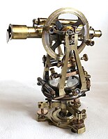
An alignment is calculated by measuring the azimuth, the angle from north, of the structure and the altitude of the horizon it faces The azimuth is usually measured using a theodolite or a compass. A compass is easier to use, though the deviation of the Earth's magnetic field from true north, known as its magnetic declination
must be taken into account. Compasses are also unreliable in areas
prone to magnetic interference, such as sites being supported by
scaffolding. Additionally a compass can only measure the azimuth to a
precision of a half a degree.
A theodolite can be considerably more accurate if used correctly,
but it is also considerably more difficult to use correctly. There is
no inherent way to align a theodolite with North and so the scale has to
be calibrated using astronomical observation, usually the position of the Sun.
Because the position of celestial bodies changes with the time of day
due to the Earth's rotation, the time of these calibration observations
must be accurately known, or else there will be a systematic error in
the measurements. Horizon altitudes can be measured with a theodolite or
a clinometer.
Artifacts
The Antikythera mechanism (main fragment)
For artifacts such as the Sky Disc of Nebra, alleged to be a Bronze Age artefact depicting the cosmos, the analysis would be similar to typical post-excavation analysis
as used in other sub-disciplines in archaeology. An artefact is
examined and attempts are made to draw analogies with historical or
ethnographical records of other peoples. The more parallels that can be
found, the more likely an explanation is to be accepted by other
archaeologists.
A more mundane example is the presence of astrological symbols found on some shoes and sandals from the Roman Empire. The use of shoes and sandals is well known, but Carol van Driel-Murray has proposed that astrological symbols etched onto sandals gave the footwear spiritual or medicinal meanings.
This is supported through citation of other known uses of astrological
symbols and their connection to medical practice and with the historical
records of the time.
Another well-known artefact with an astronomical use is the Antikythera mechanism.
In this case analysis of the artefact, and reference to the description
of similar devices described by Cicero, would indicate a plausible use
for the device. The argument is bolstered by the presence of symbols on
the mechanism, allowing the disc to be read.
Art and inscriptions
Diagram showing the location of the sun daggers on the Fajada Butte petroglyph on various days
Art and inscriptions may not be confined to artefacts, but also
appear painted or inscribed on an archaeological site. Sometimes
inscriptions are helpful enough to give instructions to a site's use.
For example, a Greek inscription on a stele (from Itanos)
has been translated as:"Patron set this up for Zeus Epopsios. Winter
solstice. Should anyone wish to know: off ‘the little pig’ and the stele
the sun turns." From Mesoamerica come Mayan and Aztec codices. These are folding books made from Amatl, processed tree bark on which are glyphs in Mayan or Aztec script. The Dresden codex contains information regarding the Venus cycle, confirming its importance to the Mayans.
More problematic are those cases where the movement of the Sun at
different times and seasons causes light and shadow interactions with petroglyphs. A widely known example is the Sun Dagger of Fajada Butte at which a glint of sunlight passes over a spiral petroglyph.
The location of a dagger of light on the petroglyph varies throughout
the year. At the summer solstice a dagger can be seen through the heart
of the spiral; at the winter solstice two daggers appear to either side
of it. It is proposed that this petroglyph was created to mark these
events. Recent studies have identified many similar sites in the US
Southwest and Northwestern Mexico.
It has been argued that the number of solstitial markers at these sites
provides statistical evidence that they were intended to mark the
solstices.
The Sun Dagger site on Fajada Butte in Chaco Canyon, New Mexico, stands
out for its explicit light markings that record all the key events of
both the solar and lunar cycles: summer solstice, winter solstice,
equinox, and the major and minor lunar standstills of the moon's 18.6 year cycle.
In addition at two other sites on Fajada Butte, there are five light
markings on petroglyphs recording the summer and winter solstices,
equinox and solar noon.
Numerous buildings and interbuilding alignments of the great houses of
Chaco Canyon and outlying areas are oriented to the same solar and lunar
directions that are marked at the Sun Dagger site.
If no ethnographic nor historical data are found which can
support this assertion then acceptance of the idea relies upon whether
or not there are enough petroglyph sites in North America that such a
correlation could occur by chance. It is helpful when petroglyphs are
associated with existing peoples. This allows ethnoastronomers to
question informants as to the meaning of such symbols.
Ethnographies
As
well as the materials left by peoples themselves, there are also the
reports of other who have encountered them. The historical records of
the Conquistadores are a rich source of information about the pre-Columbian Americans. Ethnographers also provide material about many other peoples.
Aveni uses the importance of zenith passages as an example of the
importance of ethnography. For peoples living between the tropics of
Cancer and Capricorn there are two days of the year when the noon Sun
passes directly overhead and casts no shadow. In parts of Mesoamerica
this was considered a significant day as it would herald the arrival of
rains, and so play a part in the cycle of agriculture. This knowledge is
still considered important amongst Mayan Indians living in Central
America today. The ethnographic records suggested to archaeoastronomers
that this day may have been important to the ancient Mayans. There are
also shafts known as 'zenith tubes' which illuminate subterranean rooms
when the Sun passes overhead found at places like Monte Albán and Xochicalco.
It is only through the ethnography that we can speculate that the
timing of the illumination was considered important in Mayan society.
Alignments to the sunrise and sunset on the day of the zenith passage
have been claimed to exist at several sites. However, it has been shown
that, since there are very few orientations that can be related to these
phenomena, they likely have different explanations.
Ethnographies also caution against over-interpretation of sites. At a site in Chaco Canyon can be found a pictograph with a star, crescent and hand. It has been argued by some astronomers that this is a record of the 1054 Supernova. However recent reexaminations of related 'supernova petroglyphs' raises questions about such sites in general. Cotte and Ruggles used the Supernova petroglyph as an example of a completely refuted site and anthropological evidence suggests other interpretations. The Zuni people,
who claim a strong ancestral affiliation with Chaco, marked their
sun-watching station with a crescent, star, hand and sundisc, similar to
those found at the Chaco site.
Ethnoastronomy is also an important field outside of the
Americas. For example, anthropological work with Aboriginal Australians
is producing much information about their Indigenous astronomies and about their interaction with the modern world.
Recreating the ancient sky
...[A]lthough
different ways to do science and different scientific results do arise
in different cultures, this provides little support for those who would
use such differences to question the sciences' ability to provide
reliable statements about the world in which we live.
— Stephen McCluskey
Once the researcher has data to test, it is often necessary to
attempt to recreate ancient sky conditions to place the data in its
historical environment.
To calculate what astronomical features a structure faced a
coordinate system is needed. The stars provide such a system. If you
were to go outside on a clear night you would observe the stars spinning
around the celestial pole. This point is +90° if you are watching the
North Celestial Pole or −90° if you are observing the Southern Celestial
Pole. The concentric circles the stars trace out are lines of celestial latitude, known as declination.
The arc connecting the points on the horizon due East and due West (if
the horizon is flat) and all points midway between the Celestial Poles
is the Celestial Equator which has a declination of 0°. The visible
declinations vary depending where you are on the globe. Only an observer
on the North Pole of Earth would be unable to see any stars from the
Southern Celestial Hemisphere at night (see diagram below). Once a
declination has been found for the point on the horizon that a building
faces it is then possible to say whether a specific body can be seen in
that direction.
Diagram of the visible portions of sky at varying latitudes
Solar positioning
While
the stars are fixed to their declinations the Sun is not. The rising
point of the Sun varies throughout the year. It swings between two
limits marked by the solstices a bit like a pendulum,
slowing as it reaches the extremes, but passing rapidly through the
midpoint. If an archaeoastronomer can calculate from the azimuth and
horizon height that a site was built to view a declination of +23.5°
then he or she need not wait until 21 June to confirm the site does
indeed face the summer solstice. For more information see History of solar observation.
Lunar positioning
The Moon's appearance is considerably more complex. Its motion, like the Sun, is between two limits—known as lunistices rather than solstices. However, its travel between lunistices is considerably faster. It takes a sidereal month
to complete its cycle rather than the year-long trek of the Sun. This
is further complicated as the lunistices marking the limits of the
Moon's movement move on an 18.6 year cycle.
For slightly over nine years the extreme limits of the Moon are outside
the range of sunrise. For the remaining half of the cycle the Moon
never exceeds the limits of the range of sunrise. However, much lunar
observation was concerned with the phase of the Moon. The cycle from one New Moon to the next runs on an entirely different cycle, the Synodic month.
Thus when examining sites for lunar significance the data can appear
sparse due to the extremely variable nature of the moon. See Moon for more details.
Finally there is often a need to correct for the apparent movement of
the stars. On the timescale of human civilisation the stars have
largely maintained the same position relative to each other. Each night
they appear to rotate around the celestial poles due to the Earth's
rotation about its axis. However, the Earth spins rather like a spinning top. Not only does the Earth rotate, it wobbles. The Earth's axis takes around 25,800 years to complete one full wobble.
The effect to the archaeoastronomer is that stars did not rise over the
horizon in the past in the same places as they do today. Nor did the
stars rotate around Polaris as they do now. In the case of the Egyptian pyramids, it has been shown they were aligned towards Thuban, a faint star in the constellation of Draco.
The effect can be substantial over relatively short lengths of time,
historically speaking. For instance a person born on 25 December in
Roman times would have been born with the Sun in the constellation Capricorn. In the modern period a person born on the same date would have the Sun in Sagittarius due to the precession of the equinoxes.
Additionally there are often transient phenomena, events which do not
happen on an annual cycle. Most predictable are events like eclipses. In the case of solar eclipses these can be used to date events in the past. A solar eclipse mentioned by Herodotus enables us to date a battle between the Medes and the Lydians, which following the eclipse failed to happen, to 28 May, 585 BC. Other easily calculated events are supernovae whose remains are visible to astronomers and therefore their positions and magnitude can be accurately calculated.
Some comets are predictable, most famously Halley's Comet. Yet as a class of object they remain unpredictable and can appear at any time. Some have extremely lengthy orbital periods which means their past appearances and returns cannot be predicted. Others may have only ever passed through the Solar System once and so are inherently unpredictable.
Meteor showers should be predictable, but some meteors are cometary debris and so require calculations of orbits which are currently impossible to complete. Other events noted by ancients include aurorae, sun dogs and rainbows
all of which are as impossible to predict as the ancient weather, but
nevertheless may have been considered important phenomena.
Major topics of archaeoastronomical research
What has astronomy brought into the lives of cultural groups throughout history? The answers are many and varied...
— Von Del Chamberlain and M. Jane Young
The use of calendars
A common justification for the need for astronomy is the need to develop an accurate calendar for agricultural reasons. Ancient texts like Hesiod's
Works and Days, an ancient farming manual, would appear to partially
confirm this: astronomical observations are used in combination with ecological signs, such as bird migrations to determine the seasons. Ethnoastronomical studies of the Hopi of the southwestern United States indicate that they carefully observed the rising and setting positions of the Sun to determine the proper times to plant crops. However, ethnoastronomical work with the Mursi of Ethiopia shows that their luni-solar calendar was somewhat haphazard, indicating the limits of astronomical calendars in some societies.
All the same, calendars appear to be an almost universal phenomenon in
societies as they provide tools for the regulation of communal
activities.
Other peculiar calendars include ancient Greek calendars. These were nominally lunar, starting with the New Moon. In reality the calendar could pause or skip days with confused citizens inscribing dates by both the civic calendar and ton theoi, by the moon. The lack of any universal calendar for ancient Greece suggests that coordination of panhellenic events such as games or rituals could be difficult and that astronomical symbolism may have been used as a politically neutral form of timekeeping.
Orientation measurements in Greek temples and Byzantine churches have
been associated to deity's name day, festivities, and special events.
Another motive for studying the sky is to understand and explain the universe. In these cultures myth was a tool for achieving this, and the explanations, while not reflecting the standards of modern science, are cosmologies.
The Incas arranged their empire to demonstrate their cosmology. The capital, Cusco,
was at the centre of the empire and connected to it by means of ceques,
conceptually straight lines radiating out from the centre. These ceques connected the centre of the empire to the four suyus, which were regions defined by their direction from Cusco. The notion of a quartered cosmos is common across the Andes.
Gary Urton, who has conducted fieldwork in the Andean villagers of
Misminay, has connected this quartering with the appearance of the Milky Way in the night sky. In one season it will bisect the sky and in another bisect it in a perpendicular fashion.
The importance of observing cosmological factors is also seen on the other side of the world. The Forbidden City in Beijing
is laid out to follow cosmic order though rather than observing four
directions. The Chinese system was composed of five directions: North, South, East, West and Centre. The Forbidden City occupied the centre of ancient Beijing. One approaches the Emperor from the south, thus placing him in front of the circumpolar stars.
This creates the situation of the heavens revolving around the person
of the Emperor. The Chinese cosmology is now better known through its
export as feng shui.
There is also much information about how the universe was thought to work stored in the mythology of the constellations. The Barasana of the Amazon
plan part of their annual cycle based on observation of the stars. When
their constellation of the Caterpillar-Jaguar (roughly equivalent to
the modern Scorpius) falls they prepare to catch the pupating
caterpillars of the forest as they fall from the trees. The caterpillars provide food at a season when other foods are scarce.
A more well-known source of constellation myth are the texts of
the Greeks and Romans. The origin of their constellations remains a
matter of vigorous and occasionally fractious debate.
The loss of one of the sisters, Merope, in some Greek myths may
reflect an astronomical event wherein one of the stars in the Pleiades
disappeared from view by the naked eye.
Giorgio de Santillana, professor of the History of Science in the School of Humanities at the Massachusetts Institute of Technology,
along with Hertha von Dechend believed that the old mythological
stories handed down from antiquity were not random fictitious tales but
were accurate depictions of celestial cosmology
clothed in tales to aid their oral transmission. The chaos, monsters
and violence in ancient myths are representative of the forces that
shape each age. They believed that ancient myths are the remains of
preliterate astronomy that became lost with the rise of the Greco-Roman civilization. Santillana and von Dechend in their book Hamlet's Mill, An Essay on Myth and the Frame of Time
(1969) clearly state that ancient myths have no historical or factual
basis other than a cosmological one encoding astronomical phenomena,
especially the precession of the equinoxes. Santillana and von Dechend's approach is not widely accepted.
By including celestial motifs in clothing it becomes possible for the
wearer to make claims the power on Earth is drawn from above. It has
been said that the Shield of Achilles described by Homer is also a catalogue of constellations. In North America shields depicted in Comanchepetroglyphs appear to include Venus symbolism.
Solsticial alignments also can be seen as displays of power. When viewed from a ceremonial plaza on the Island of the Sun (the mythical origin place of the Sun) in Lake Titicaca,
the Sun was seen to rise at the June solstice between two towers on a
nearby ridge. The sacred part of the island was separated from the
remainder of it by a stone wall and ethnographic records indicate that
access to the sacred space was restricted to members of the Inca ruling elite. Ordinary pilgrims stood on a platform outside the ceremonial area to see the solstice Sun rise between the towers.
In Egypt the temple of Amun-Re at Karnak has been the subject of much study. Evaluation of the site, taking into account the change over time of the obliquity of the ecliptic show that the Great Temple was aligned on the rising of the midwinter Sun.The length of the corridor down which sunlight would travel would have limited illumination at other times of the year.
In a later period the Serapeum in Alexandria was also said to have contained a solar alignment so that, on a specific sunrise, a shaft of light would pass across the lips of the statue of Serapis thus symbolising the Sun saluting the god.
Clive Ruggles and Michel Cotte
recently edited a book on heritage sites of astronomy and
archaeoastronomy that provides a list of the main sites around the
world.
At Stonehenge in England and at
Carnac in France, in Egypt and Yucatán, across the whole face of the
earth, are found mysterious ruins of ancient monuments, monuments with
astronomical significance... They mark the same kind of commitment that
transported us to the moon and our spacecraft to the surface of Mars.
— Edwin Krupp
Newgrange
The sunlight enters the tomb at Newgrange via the roofbox built above the door.
Newgrange is a passage tomb in the Republic of Ireland dating from around 3,300 to 2,900 BC
For a few days around the Winter Solstice light shines along the
central passageway into the heart of the tomb. What makes this notable
is not that light shines in the passageway, but that it does not do so
through the main entrance. Instead it enters via a hollow box above the
main doorway discovered by Michael O'Kelly.
It is this roofbox which strongly indicates that the tomb was built
with an astronomical aspect in mind. In their discussion of the
credibility of archaeoastronomical sites, Cotte and Ruggles gave
Newgrange as an example of a Generally accepted site, the highest of
their four levels of credibility. Clive Ruggles notes:
...[F]ew
people—archaeologists or astronomers—have doubted that a powerful
astronomical symbolism was deliberately incorporated into the monument,
demonstrating that a connection between astronomy and funerary ritual,
at the very least, merits further investigation.
Since the first modern measurements of the precise cardinal orientations of the pyramids by Flinders Petrie, various astronomical methods have been proposed for the original establishment of these orientations. It was recently proposed that this was done by observing the positions of two stars in the Plough / Big Dipper which was known to Egyptians as the thigh. It is thought that a vertical alignment between these two stars checked with a plumb bob
was used to ascertain where north lay. The deviations from true north
using this model reflect the accepted dates of construction.
Constellations on the astronomical ceiling of Senemut Tomb
Some have argued that the pyramids were laid out as a map of the three stars in the belt of Orion, although this theory has been criticized by reputable astronomers.
The site was instead probably governed by a spectacular hierophany
which occurs at the summer solstice, when the Sun, viewed from the
Sphinx terrace, forms—together with the two giant pyramids—the symbol
Akhet, which was also the name of the Great Pyramid. Further, the south
east corners of all the three pyramids align towards the temple of
Heliopolis, as first discovered by the Egyptologist Mark Lehner.
The astronomical ceiling of the tomb of Senenmut (c. 1470BC)
contains the Celestial Diagram depicting circumpolar constellations in
the form of discs. Each disc is divided into 24 sections suggesting a
24-hour time period. Constellations are portrayed as sacred deities of
Egypt. The observation of lunar cycles is also evident.
El Castillo, also known as Kukulcán's Pyramid, is a Mesoamerican step-pyramid built in the centre of Mayan center of Chichen Itza
in Mexico. Several architectural features have suggested astronomical
elements. Each of the stairways built into the sides of the pyramid has
91 steps. Along with the extra one for the platform at the top, this
totals 365 steps, which is possibly one for each day of the year
(365.25) or the number of lunar orbits in 10,000 rotations (365.01).
Plumed Serpent
A visually striking effect is seen every March and September as an
unusual shadow occurs around the equinoxes. Light and shadow phenomena
have been proposed to explain a possible architectural hierophany
involving the sun at Chichén Itzá in a Maya Toltec structure dating to
about 1000 CE.
A shadow appears to descend the west balustrade of the northern
stairway. The visual effect is of a serpent descending the stairway,
with its head at the base in light. Additionally the western face points
to sunset around 25 May, traditionally the date of transition from the
dry to the rainy season.
The intended alignment was, however, likely incorporated in the
northern (main) facade of the temple, as it corresponds to sunsets on
May 20 and July 24, recorded also by the central axis of Castillo at
Tulum.
The two dates are separated by 65 and 300 days, and it has been shown
that the solar orientations in Mesoamerica regularly correspond to dates
separated by calendrically significant intervals (multiples of 13 and
20 days).
In their discussion of the credibility of archaeoastronomical sites,
Cotte and Ruggles used the "equinox hierophany" at Chichén Itzá as an
example of an Unproven site, the third of their four levels of
credibility.
Many astronomical alignments have been claimed for Stonehenge, a complex of megaliths and earthworks in the Salisbury Plain
of England. The most famous of these is the midsummer alignment, where
the Sun rises over the Heel Stone. However, this interpretation has been
challenged by some archaeologists who argue that the midwinter
alignment, where the viewer is outside Stonehenge and sees the Sun
setting in the henge, is the more significant alignment, and the
midsummer alignment may be a coincidence due to local topography.
In their discussion of the credibility of archaeoastronomical sites,
Cotte and Ruggles gave Stonehenge as an example of a Generally accepted
site, the highest of their four levels of credibility.
As well as solar alignments, there are proposed lunar alignments.
The four station stones mark out a rectangle. The short sides point
towards the midsummer sunrise and midwinter sunset. The long sides if
viewed towards the south-east, face the most southerly rising of the
Moon. Aveni notes that these lunar alignments have never gained the
acceptance that the solar alignments have received.
The Heel Stone azimuth is one-seventh of circumference, matching the
latitude of Avebury, while summer solstice sunrise azimuth is no longer
equal to the construction era direction.
This is an architecturally outstanding Neolithic chambered tomb on the mainland of Orkney, Scotland—probably
dating to the early 3rd millennium BC, and where the setting Sun at
midwinter shines down the entrance passage into the central chamber (see
Newgrange). In the 1990s further investigations were carried out to
discover whether this was an accurate or an approximate solar alignment.
Several new aspects of the site were discovered. In the first place the
entrance passage faces the hills of the island Hoy,
about 10 miles away. Secondly, it consists of two straight lengths,
angled at a few degrees to each other. Thirdly, the outer part is
aligned towards the midwinter sunset position on a level horizon just to
the left of Ward Hill on Hoy. Fourthly the inner part points directly
at the Barnhouse standing stone about 400m away and then to the right
end of the summit of Ward Hill, just before it dips down to the notch
between it at Cuilags to the right. This indicated line points to sunset
on the first Sixteenths of the solar year (according to A. Thom) before
and after the winter solstice and the notch at the base of the right
slope of the Hill is at the same declination. Fourthly a similar 'double
sunset' phenomenon is seen at the right end of Cuilags, also on Hoy;
here the date is the first Eighth of the year before and after the
winter solstice, at the beginning of November and February
respectively—the Old Celtic festivals of Samhain and Imbolc.
This alignment is not indicated by an artificial structure but gains
plausibility from the other two indicated lines. Maeshowe is thus an
extremely sophisticated calendar site which must have been positioned
carefully in order to use the horizon foresights in the ways described.
Uxmal is a Mayan city in the Puuc Hills of Yucatán Peninsula,
Mexico. The Governor's Palace at Uxmal is often used as an exemplar of
why it is important to combine ethnographic and alignment data. The
palace is aligned with an azimuth
of 118° on the pyramid of Cehtzuc. This alignment corresponds
approximately to the southernmost rising and, with a much greater
precision, to the northernmost setting of Venus; both phenomena occur
once every eight years. By itself this would not be sufficient to argue
for a meaningful connection between the two events. The palace has to be
aligned in one direction or another and why should the rising of Venus
be any more important than the rising of the Sun, Moon, other planets,
Sirius et cetera? The answer given is that not only does the palace point towards significant points of Venus, it is also covered in glyphs which stand for Venus and Mayan zodiacal constellations.
Moreover, the great northerly extremes of Venus always occur in late
April or early May, coinciding with the onset of the rainy season. The
Venus glyphs placed in the cheeks of the Maya rain god Chac, most likely
referring to the concomitance of these phenomena, support the
west-working orientation scheme.
Chaco Canyon
The Great Kiva at Chaco Canyon
In Chaco Canyon, the center of the ancient Pueblo culture in the
American Southwest, numerous solar and lunar light markings and
architectural and road alignments have been documented. These findings
date to the 1977 discovery of the Sun Dagger site by Anna Sofaer.
Three large stone slabs leaning against a cliff channel light and
shadow markings onto two spiral petroglyphs on the cliff wall, marking
the solstices, equinoxes and the lunar standstills of the 18.6 year
cycle of the moon.
Subsequent research by the Solstice Project and others demonstrated
that numerous building and interbuilding alignments of the great houses
of Chaco Canyon are oriented to solar, lunar and cardinal directions.
In addition, research shows that the Great North Road, a thirty-five
mile engineered “road”, was constructed not for utilitarian purposes but
rather to connect the ceremonial center of Chaco Canyon with the
direction north.
Lascaux Cave
According
to Rappenglueck, the eyes of the bull, the bird, and the bird-man may
represent the three stars Vega, Altair, and Deneb commonly known as the Summer Triangle.
In recent years, new research has suggested that the Lascaux cave paintings in France may incorporate prehistoric star charts. Michael Rappenglueck of the University of Munich
argues that some of the non-figurative dot clusters and dots within
some of the figurative images correlate with the constellations of Taurus, the Pleiades and the grouping known as the "Summer Triangle". Based on her own study of the astronomical significance of Bronze Age petroglyphs in the Vallée des Merveilles
and her extensive survey of other prehistoric cave painting sites in
the region—most of which appear to have been selected because the
interiors are illuminated by the setting Sun on the day of the winter solstice—French
researcher Chantal Jègues-Wolkiewiez has further proposed that the
gallery of figurative images in the Great Hall represents an extensive
star map and that key points on major figures in the group correspond to
stars in the main constellations as they appeared in the Paleolithic.Appliying phylogenetics to myths of the Cosmic Hunt, Julien d'Huy
suggested that the palaeolithic version of this story could be the
following: there is an animal that is a horned herbivore, especially an
elk. One human pursues this ungulate. The hunt locates or gets to the
sky. The animal is alive when it is transformed into a constellation. It
forms the Big Dipper. This story may be represented in the famous
Lascaux shaft ‘scene’
Fringe archaeoastronomy
At
least now we have all the archaeological facts to go along with the
astronomers, the Druids, the Flat Earthers and all the rest.
— Sir Jocelyn Stephens
Archaeoastronomy owes something of this poor reputation among scholars to its occasional misuse to advance a range of pseudo-historical accounts. During the 1930s, Otto S. Reuter compiled a study entitled Germanische Himmelskunde,
or "Teutonic Skylore". The astronomical orientations of ancient
monuments claimed by Reuter and his followers would place the ancient
Germanic peoples ahead of the Ancient Near East in the field of astronomy, demonstrating the intellectual superiority of the "Aryans" (Indo-Europeans) over the Semites.
More recently Gallagher, Pyle, and Fell interpreted inscriptions in West Virginia as a description in Celtic Ogham
alphabet of the supposed winter solstitial marker at the site. The
controversial translation was supposedly validated by a problematic
archaeoastronomical indication in which the winter solstice Sun shone on
an inscription of the Sun at the site. Subsequent analyses criticized
its cultural inappropriateness, as well as its linguistic and
archeaoastronomical claims, to describe it as an example of "cult archaeology".
Archaeoastronomy is sometimes related to the fringe discipline of Archaeocryptography,
when its followers attempt to find underlying mathematical orders
beneath the proportions, size, and placement of archaeoastronomical
sites such as Stonehenge and the Pyramid of Kukulcán at Chichen Itza.
Since the 19th century, numerous scholars have sought to use archaeoastronomical calculations
to demonstrate the antiquity of Ancient Indian Vedic culture, computing
the dates of astronomical observations ambiguously described in ancient
poetry to as early as 4000 BC. David Pingree,
a historian of Indian astronomy, condemned "the scholars who perpetrate
wild theories of prehistoric science and call themselves
archaeoastronomers."
Archaeoastronomical organisations and publications
Additionally the Journal for the History of Astronomy publishes many archaeoastronomical papers. For twenty-seven volumes (from 1979 to 2002) it published an annual supplement Archaeoastronomy. The Journal of Astronomical History and Heritage (National Astronomical Research Institute of Thailand), Culture & Cosmos (University of Wales, UK) and Mediterranean Archaeology and Archaeometry (University of Aegean, Greece) also publish papers on archaeoastronomy.
Various national archaeoastronomical projects have been
undertaken. Among them is the program at the Tata Institute of
Fundamental Research named "Archaeo Astronomy in Indian Context" that has made interesting findings in this field.