Search This Blog

Sunday, July 23, 2023

Viet Cong

From Wikipedia, the free encyclopedia

Viet Cong

The Viet Cong is a colloquial name used to designate an armed communist organization and movement in South Vietnam, Laos and Cambodia. Formally organized as the National Liberation Front of South Vietnam, Viet Cong fought under the direction of North Vietnam against the South Vietnamese and United States governments during the Vietnam War. It had both guerrilla and regular army units, as well as a network of cadres who organized and mobilized peasants in the territory the Viet Cong controlled. During the war, communist fighters and some anti-war activists claimed that the Viet Cong was an insurgency indigenous to the South, while the U.S. and South Vietnamese governments portrayed the group as a tool of North Vietnam. According to Trần Văn Trà, the Viet Cong's top commander, and the post-war Vietnamese government's official history, the Viet Cong followed orders from Hanoi and were part of the People's Army of Vietnam, or North Vietnamese army.

North Vietnam established the National Liberation Front as a front group for the Viet Cong on December 20, 1960, at Tân Lập village in Tây Ninh Province to foment insurgency in the South. Many of the Viet Cong's core members were volunteer "regroupees", southern Viet Minh who had resettled in the North after the Geneva Accord (1954). Hanoi gave the regroupees military training and sent them back to the South along the Ho Chi Minh trail in the late 1950s and early 1960s. The Viet Cong called for the unification of Vietnam and the overthrow of the American backed South Vietnamese government. The Viet Cong's best-known action was the Tet Offensive, an assault on more than 100 South Vietnamese urban centers in 1968, including an attack on the U.S. embassy in Saigon. The offensive riveted the attention of the world's media for weeks, but also overextended the Viet Cong. Later communist offensives were conducted predominantly by the North Vietnamese. The organization officially merged with the Fatherland Front of Vietnam on February 4, 1977, after North and South Vietnam were officially unified under a communist government.

Names

The term Việt Cộng appeared in Saigon newspapers beginning in 1956. It is a contraction of Việt Nam cộng sản (Vietnamese communist). The earliest citation for Viet Cong in English is from 1957. American soldiers referred to the Viet Cong as Victor Charlie or V-C. "Victor" and "Charlie" are both letters in the NATO phonetic alphabet. "Charlie" referred to communist forces in general, both Viet Cong and North Vietnamese.

The official Vietnamese history gives the group's name as the Liberation Army of South Vietnam or the National Liberation Front of South Vietnam (NLFSV; Mặt trận Dân tộc Giải phóng miền Nam Việt Nam). Many writers shorten this to National Liberation Front (NLF). In 1969, the Viet Cong created the "Provisional Revolutionary Government of the Republic of South Vietnam" (Chính Phủ Cách Mạng Lâm Thời Cộng Hòa Miền Nam Việt Nam), abbreviated PRG. Although the NLF was not officially abolished until 1977, the Viet Cong no longer used the name after the PRG was created. Members generally referred to the Viet Cong as "the Front" (Mặt trận). Today's Vietnamese media most frequently refers to the group as the "Liberation Army of South Vietnam" (Quân Giải phóng Miền Nam Việt Nam) .

History

Origin

Soldiers and civilians took supplies south on the Ho Chi Minh trail (1959)

By the terms of the Geneva Accord (1954), which ended the Indochina War, France and the Viet Minh agreed to a truce and to a separation of forces. The Viet Minh had become the government of North Vietnam, and military forces of the communists regrouped there. Military forces of the non-communists regrouped in South Vietnam, which became a separate state. Elections on reunification were scheduled for July 1956. A divided Vietnam angered Vietnamese nationalists, but it made the country less of a threat to China. Chinese Premier Zhou Enlai negotiated the terms of the ceasefire with France and then imposed them on the Viet Minh.

About 90,000 Viet Minh were evacuated to the North while 5,000 to 10,000 cadre remained in the South, most of them with orders to refocus on political activity and agitation. The Saigon-Cholon Peace Committee, the first Viet Cong front, was founded in 1954 to provide leadership for this group. Other front names used by the Viet Cong in the 1950s implied that members were fighting for religious causes, for example, "Executive Committee of the Fatherland Front", which suggested affiliation with the Hòa Hảo sect, or "Vietnam-Cambodia Buddhist Association". Front groups were favored by the Viet Cong to such an extent that its real leadership remained shadowy until long after the war was over, prompting the expression "the faceless Viet Cong".

US Military map of Communist forces in South Vietnam in early 1964

Led by Ngô Đình Diệm, South Vietnam refused to sign the Geneva Accord. Arguing that a free election was impossible under the conditions that existed in communist-held territory, Diệm announced in July 1955 that the scheduled election on reunification would not be held. After subduing the Bình Xuyên organized crime gang in the Battle for Saigon in 1955, and the Hòa Hảo and other militant religious sects in early 1956, Diệm turned his attention to the Viet Cong. Within a few months, the Viet Cong had been driven into remote swamps. The success of this campaign inspired U.S. President Dwight Eisenhower to dub Diệm the "miracle man" when he visited the U.S. in May 1957. France withdrew its last soldiers from Vietnam in April 1956.

In March 1956, southern communist leader Lê Duẩn presented a plan to revive the insurgency entitled "The Road to the South" to the other members of the Politburo in Hanoi. He argued adamantly that war with the United States was necessary to achieve unification. But as China and the Soviets both opposed confrontation at this time, Lê Duẩn's plan was rejected and communists in the South were ordered to limit themselves to economic struggle. Leadership divided into a "North first", or pro-Beijing, faction led by Trường Chinh, and a "South first" faction led by Lê Duẩn.

As the Sino-Soviet split widened in the following months, Hanoi began to play the two communist giants off against each other. The North Vietnamese leadership approved tentative measures to revive the southern insurgency in December 1956. Lê Duẩn's blueprint for revolution in the South was approved in principle, but implementation was conditional on winning international support and on modernizing the army, which was expected to take at least until 1959. President Hồ Chí Minh stressed that violence was still a last resort. Nguyễn Hữu Xuyên was assigned military command in the South, replacing Lê Duẩn, who was appointed North Vietnam's acting party boss. This represented a loss of power for Hồ, who preferred the more moderate Võ Nguyên Giáp, who was defense minister.

A photo from the U.S. Information Agency allegedly showing a 23-year-old Le Van Than, who had defected from the Communist forces and joined the South Vietnam Government side and was later recaptured by the Viet Cong and spent a month in a Viet Cong internment camp.

An assassination campaign, referred to as "extermination of traitors"  or "armed propaganda" in communist literature, began in April 1957. Tales of sensational murder and mayhem soon crowded the headlines. Seventeen civilians were killed by machine gun fire at a bar in Châu Đốc in July and in September a district chief was killed with his entire family on a main highway in broad daylight. In October 1957, a series of bombs exploded in Saigon and left 13 Americans wounded.

In a speech given on September 2, 1957, Hồ reiterated the "North first" line of economic struggle. The launch of Sputnik in October boosted Soviet confidence and led to a reassessment of policy regarding Indochina, long treated as a Chinese sphere of influence. In November, Hồ traveled to Moscow with Lê Duẩn and gained approval for a more militant line. In early 1958, Lê Duẩn met with the leaders of "Inter-zone V" (northern South Vietnam) and ordered the establishment of patrols and safe areas to provide logistical support for activity in the Mekong Delta and in urban areas. In June 1958, the Viet Cong created a command structure for the eastern Mekong Delta. French scholar Bernard Fall published an influential article in July 1958 which analyzed the pattern of rising violence and concluded that a new war had begun.

Launches armed struggle

The Communist Party of Vietnam approved a "people's war" on the South at a session in January 1959 and this decision was confirmed by the Politburo in March. In May 1959, Group 559 was established to maintain and upgrade the Ho Chi Minh trail, at this time a six-month mountain trek through Laos. About 500 of the "regroupees" of 1954 were sent south on the trail during its first year of operation. The first arms delivery via the trail, a few dozen rifles, was completed in August 1959.

Two regional command centers were merged to create the Central Office for South Vietnam (Trung ương Cục miền Nam), a unified communist party headquarters for the South. COSVN was initially located in Tây Ninh Province near the Cambodian border. On July 8, the Viet Cong killed two U.S. military advisors at Biên Hòa, the first American dead of the Vietnam War. The "2d Liberation Battalion" ambushed two companies of South Vietnamese soldiers in September 1959, the first large unit military action of the war. This was considered the beginning of the "armed struggle" in communist accounts. A series of uprisings beginning in the Mekong Delta province of Bến Tre in January 1960 created "liberated zones", models of Viet Cong-style government. Propagandists celebrated their creation of battalions of "long-hair troops" (women). The fiery declarations of 1959 were followed by a lull while Hanoi focused on events in Laos (1960–61). Moscow favored reducing international tensions in 1960, as it was election year for the U.S. presidency. Despite this, 1960 was a year of unrest in South Vietnam, with pro-democracy demonstrations inspired by the South Korean student uprising that year and a failed military coup in November.

Brinks Hotel, Saigon, following a Viet Cong bombing on December 24, 1964. Two American officers were killed.

To counter the accusation that North Vietnam was violating the Geneva Accord, the independence of the Viet Cong was stressed in communist propaganda. The Viet Cong created the National Liberation Front of South Vietnam in December 1960 at Tân Lập village in Tây Ninh as a "united front", or political branch intended to encourage the participation of non-communists. The group's formation was announced by Radio Hanoi and its ten-point manifesto called for, "overthrow the disguised colonial regime of the imperialists and the dictatorial administration, and to form a national and democratic coalition administration." Thọ, a lawyer and the Viet Cong's "neutralist" chairman, was an isolated figure among cadres and soldiers. South Vietnam's Law 10/59, approved in May 1959, authorized the death penalty for crimes "against the security of the state" and featured prominently in Viet Cong propaganda. Violence between the Viet Cong and government forces soon increased drastically from 180 clashes in January 1960 to 545 clashes in September.

By 1960, the Sino-Soviet split was a public rivalry, making China more supportive of Hanoi's war effort. For Chinese leader Mao Zedong, aid to North Vietnam was a way to enhance his "anti-imperialist" credentials for both domestic and international audiences. About 40,000 communist soldiers infiltrated the South in 1961–63. The Viet Cong grew rapidly; an estimated 300,000 members were enrolled in "liberation associations" (affiliated groups) by early 1962. The ratio of Viet Cong to government soldiers jumped from 1:10 in 1961 to 1:5 a year later.

A Viet Cong prisoner captured in 1967 by the U.S. Army awaits interrogation.

The level of violence in the South jumped dramatically in the fall of 1961, from 50 guerrilla attacks in September to 150 in October. U.S. President John F. Kennedy decided in November 1961 to substantially increase American military aid to South Vietnam. The USS Core arrived in Saigon with 35 helicopters in December 1961. By mid-1962, there were 12,000 U.S. military advisors in Vietnam. The "special war" and "strategic hamlets" policies allowed Saigon to push back in 1962, but in 1963 the Viet Cong regained the military initiative. The Viet Cong won its first military victory against South Vietnamese forces at Ấp Bắc in January 1963.

A landmark party meeting was held in December 1963, shortly after a military coup in Saigon in which Diệm was assassinated. North Vietnamese leaders debated the issue of "quick victory" vs "protracted war" (guerrilla warfare). After this meeting, the communist side geared up for a maximum military effort and the troop strength of the People's Army of Vietnam (PAVN) increased from 174,000 at the end of 1963 to 300,000 in 1964. The Soviets cut aid in 1964 as an expression of annoyance with Hanoi's ties to China. Even as Hanoi embraced China's international line, it continued to follow the Soviet model of reliance on technical specialists and bureaucratic management, as opposed to mass mobilization. The winter of 1964–1965 was a high-water mark for the Viet Cong, with the Saigon government on the verge of collapse. Soviet aid soared following a visit to Hanoi by Soviet Premier Alexei Kosygin in February 1965. Hanoi was soon receiving up-to-date surface-to-air missiles. The U.S. would have 200,000 soldiers in South Vietnam by the end of the year.

A U.S. Air Force Douglas Skyraider drops a white phosphorus bomb on a Viet Cong position in South Vietnam in 1966.

In January 1966, Australian troops uncovered a tunnel complex that had been used by COSVN. Six thousand documents were captured, revealing the inner workings of the Viet Cong. COSVN retreated to Mimot in Cambodia. As a result of an agreement with the Cambodian government made in 1966, weapons for the Viet Cong were shipped to the Cambodian port of Sihanoukville and then trucked to Viet Cong bases near the border along the "Sihanouk Trail", which replaced the Ho Chi Minh Trail.

Many Liberation Army of South Vietnam units operated at night, and employed terror as a standard tactic. Rice procured at gunpoint sustained the Viet Cong. Squads were assigned monthly assassination quotas. Government employees, especially village and district heads, were the most common targets. But there were a wide variety of targets, including clinics and medical personnel. Notable Viet Cong atrocities include the massacre of over 3,000 unarmed civilians at Huế, 48 killed in the bombing of My Canh floating restaurant in Saigon in June 1965 and a massacre of 252 Montagnards in the village of Đắk Sơn in December 1967 using flamethrowers. Viet Cong death squads assassinated at least 37,000 civilians in South Vietnam; the real figure was far higher since the data mostly cover 1967–72. They also waged a mass murder campaign against civilian hamlets and refugee camps; in the peak war years, nearly a third of all civilian deaths were the result of Viet Cong atrocities. Ami Pedahzur has written that "the overall volume and lethality of Vietcong terrorism rivals or exceeds all but a handful of terrorist campaigns waged over the last third of the twentieth century".
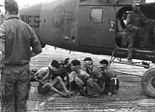
Viet Cong soldiers captured by US Marines outside of Dong Ha, RVN 1968

Logistics and equipment

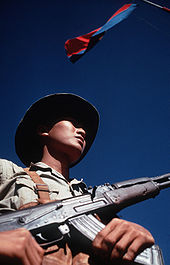
Looking from the waist up, a man wearing a hat and holding an assault rifle with one hand holding the magazine and the other on the pistol grip
Viet Cong soldier stands beneath a Viet Cong flag with an AK-47 rifle.

Tet Offensive

Major reversals in 1966 and 1967, as well as the growing American presence in Vietnam, inspired Hanoi to consult its allies and reassess strategy in April 1967. While Beijing urged a fight to the finish, Moscow suggested a negotiated settlement. Convinced that 1968 could be the last chance for decisive victory, General Nguyễn Chí Thanh, suggested an all-out offensive against urban centers. He submitted a plan to Hanoi in May 1967. After Thanh's death in July, Giáp was assigned to implement this plan, now known as the Tet Offensive. The Parrot's Beak, an area in Cambodia only 30 miles from Saigon, was prepared as a base of operations. Funeral processions were used to smuggle weapons into Saigon. Viet Cong entered the cities concealed among civilians returning home for Tết. The U.S. and South Vietnamese expected that an announced seven-day truce would be observed during Vietnam's main holiday.

A U.S. propaganda leaflet urges Viet Cong to defect using the Chiêu Hồi Program.

At this point, there were about 500,000 U.S. troops in Vietnam, as well as 900,000 allied forces. General William Westmoreland, the U.S. commander, received reports of heavy troop movements and understood that an offensive was being planned, but his attention was focused on Khe Sanh, a remote U.S. base near the DMZ. In January and February 1968, some 80,000 Viet Cong struck more than 100 towns with orders to "crack the sky" and "shake the Earth." The offensive included a commando raid on the U.S. Embassy in Saigon and a massacre at Huế of about 3,500 residents. House-to-house fighting between Viet Cong and South Vietnamese Rangers left much of Cholon, a section of Saigon, in ruins. The Viet Cong used any available tactic to demoralize and intimidate the population, including the assassination of South Vietnamese commanders. A photo by Eddie Adams showing the summary execution of a Viet Cong in Saigon on February 1 became a symbol of the brutality of the war. In an influential broadcast on February 27, newsman Walter Cronkite stated that the war was a "stalemate" and could be ended only by negotiation.

The offensive was undertaken in the hope of triggering a general uprising, but urban Vietnamese did not respond as the Viet Cong anticipated. About 75,000 communist soldiers were killed or wounded, according to Trần Văn Trà, commander of the "B-2" district, which consisted of southern South Vietnam. "We did not base ourselves on scientific calculation or a careful weighing of all factors, but...on an illusion based on our subjective desires", Trà concluded. Earle G. Wheeler, chairman of the Joint Chiefs of Staff, estimated that Tet resulted in 40,000 communist dead (compared to about 10,600 U.S. and South Vietnamese dead). "It is a major irony of the Vietnam War that our propaganda transformed this debacle into a brilliant victory. The truth was that Tet cost us half our forces. Our losses were so immense that we were unable to replace them with new recruits", said PRG Justice Minister Trương Như Tảng. Tet had a profound psychological impact because South Vietnamese cities were otherwise safe areas during the war. U.S. President Lyndon Johnson and Westmoreland argued that panicky news coverage gave the public the unfair perception that America had been defeated.

Aside from some districts in the Mekong Delta, the Viet Cong failed to create a governing apparatus in South Vietnam following Tet, according to an assessment of captured documents by the U.S. CIA. The breakup of larger Viet Cong units increased the effectiveness of the CIA's Phoenix Program (1967–72), which targeted individual leaders, as well as the Chiêu Hồi Program, which encouraged defections. By the end of 1969, there was little communist-held territory, or "liberated zones", in South Vietnam, according to the official communist military history. There were no predominantly southern units left and 70 percent of communist troops in the South were northerners.

The Viet Cong created an urban front in 1968 called the Alliance of National, Democratic, and Peace Forces. The group's manifesto called for an independent, non-aligned South Vietnam and stated that "national reunification cannot be achieved overnight." In June 1969, the alliance merged with the Viet Cong to form a "Provisional Revolutionary Government" (PRG).

Vietnamization

The Tet Offensive increased American public discontent with participation in the Vietnam War and led the U.S. to gradually withdraw combat forces and to shift responsibility to the South Vietnamese, a process called Vietnamization. Pushed into Cambodia, the Viet Cong could no longer draw South Vietnamese recruits. In May 1968, Trường Chinh urged "protracted war" in a speech that was published prominently in the official media, so the fortunes of his "North first" fraction may have revived at this time. COSVN rejected this view as "lacking resolution and absolute determination." The Soviet invasion of Czechoslovakia in August 1968 led to intense Sino-Soviet tension and to the withdrawal of Chinese forces from North Vietnam. Beginning in February 1970, Lê Duẩn's prominence in the official media increased, suggesting that he was again top leader and had regained the upper hand in his longstanding rivalry with Trường Chinh. After the overthrow of Prince Sihanouk in March 1970, the Viet Cong faced a hostile Cambodian government which authorized a U.S. offensive against its bases in April. However, the capture of the Plain of Jars and other territory in Laos, as well as five provinces in northeastern Cambodia, allowed the North Vietnamese to reopen the Ho Chi Minh trail. Although 1970 was a much better year for the Viet Cong than 1969, it would never again be more than an adjunct to the PAVN. The 1972 Easter Offensive was a direct North Vietnamese attack across the DMZ between North and South. Despite the Paris Peace Accords, signed by all parties in January 1973, fighting continued. In March, Trà was recalled to Hanoi for a series of meetings to hammer out a plan for an enormous offensive against Saigon.
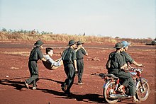
Viet Cong soldiers carry an injured American POW to a prisoner swap in 1973. The VC uniform was a floppy jungle hat, rubber sandals, and green fatigues without rank or insignia.

Fall of Saigon

In response to the anti-war movement, the U.S. Congress passed the Case–Church Amendment to prohibit further U.S. military intervention in Vietnam in June 1973 and reduced aid to South Vietnam in August 1974. With U.S. bombing ended, communist logistical preparations could be accelerated. An oil pipeline was built from North Vietnam to Viet Cong headquarters in Lộc Ninh, about 75 miles northwest of Saigon. (COSVN was moved back to South Vietnam following the Easter Offensive.) The Ho Chi Minh Trail, beginning as a series of treacherous mountain tracks at the start of the war, was upgraded throughout the war, first into a road network driveable by trucks in the dry season, and finally, into paved, all-weather roads that could be used year-round, even during the monsoon. Between the beginning of 1974 and April 1975, with now-excellent roads and no fear of air interdiction, the communists delivered nearly 365,000 tons of war matériel to battlefields, 2.6 times the total for the previous 13 years.

The success of the 1973–74 dry season offensive convinced Hanoi to accelerate its timetable. When there was no U.S. response to a successful communist attack on Phước Bình in January 1975, South Vietnamese morale collapsed. The next major battle, at Buôn Ma Thuột in March, was a communist walkover. After the fall of Saigon on April 30, 1975, the PRG moved into government offices there. At the victory parade, Tạng noticed that the units formerly dominated by southerners were missing, replaced by northerners years earlier. The bureaucracy of the Republic of Vietnam was uprooted and authority over the South was assigned to the PAVN. People considered tainted by association with the former South Vietnamese government were sent to re-education camps, despite the protests of the non-communist PRG members including Tạng. Without consulting the PRG, North Vietnamese leaders decided to rapidly dissolve the PRG at a party meeting in August 1975. North and South were merged as the Socialist Republic of Vietnam in July 1976 and the PRG was dissolved. The Viet Cong was merged with the Vietnamese Fatherland Front on February 4, 1977.

Relationship with Hanoi

Activists opposing American involvement in Vietnam said that the Viet Cong was a nationalist insurgency indigenous to the South. They said that the Viet Cong was composed of several parties—the People's Revolutionary Party, the Democratic Party and the Radical Socialist Party—and that Viet Cong chairman Nguyễn Hữu Thọ was not a communist.

Anti-communists countered that the Viet Cong was merely a front for Hanoi. They said some statements issued by communist leaders in the 1980s and 1990s suggested that southern communist forces were influenced by Hanoi. According to the memoirs of Trần Văn Trà, the Viet Cong's top commander and PRG defense minister, he followed orders issued by the "Military Commission of the Party Central Committee" in Hanoi, which in turn implemented resolutions of the Politburo. Trà himself was deputy chief of staff for the PAVN before being assigned to the South. The official Vietnamese history of the war states that "The Liberation Army of South Vietnam [Viet Cong] is a part of the People's Army of Vietnam".
Polynesian navigation

From Wikipedia, the free encyclopedia
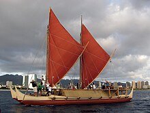
Hōkūleʻa, Hawaiian double-hulled canoe sailing off Honolulu, 2009
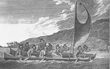
Hawaiian navigators sailing multi-hulled canoe, c. 1781

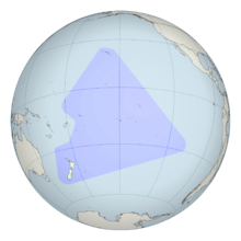
Polynesian navigation or Polynesian wayfinding was used for thousands of years to enable long voyages across thousands of kilometers of the open Pacific Ocean. Polynesians made contact with nearly every island within the vast Polynesian Triangle, using outrigger canoes or double-hulled canoes. The double-hulled canoes were two large hulls, equal in length, and lashed side by side. The space between the paralleled canoes allowed for storage of food, hunting materials, and nets when embarking on long voyages. Polynesian navigators used wayfinding techniques such as the navigation by the stars, and observations of birds, ocean swells, and wind patterns, and relied on a large body of knowledge from oral tradition.

Navigators travelled to small inhabited islands using wayfinding techniques and knowledge passed by oral tradition from master to apprentice, often in the form of song. Generally, each island maintained a guild of navigators who had very high status; in times of famine or difficulty, they could trade for aid or evacuate people to neighbouring islands. As of 2014, these traditional navigation methods are still taught in the Polynesian outlier of Taumako in the Solomons and by voyaging societies throughout the Pacific.

Both wayfinding techniques and outrigger canoe construction methods have been kept as guild secrets, but in the modern revival of these skills, they are being recorded and published.

History

The Polynesian triangle

Between about 3000 and 1000 BC speakers of Austronesian languages spread through the islands of Southeast Asia – most likely starting out from Taiwan, as tribes whose natives were thought to have previously arrived from mainland South China about 8000 years ago – into the edges of western Micronesia and on into Melanesia, through the Philippines and Indonesia. In the archeogenetic record, there are well-defined traces of this expansion that allow the path it took to be followed and dated with a degree of certainty. In the mid-2nd millennium BC, a distinctive culture appeared suddenly in north-west Melanesia, in the Bismarck Archipelago, the chain of islands forming a great arch from New Britain to the Admiralty Islands.

This culture, known as Lapita, stands out in the Melanesian archeological record, with its large permanent villages on beach terraces along the coasts. Particularly characteristic of the Lapita culture is the making of pottery, including a great many vessels of varied shapes, some distinguished by fine patterns and motifs pressed into the clay. Between about 1300 and 900 BC, the Lapita culture spread 6,000 km (3,700 mi) farther to the east from the Bismarck Archipelago, until it reached as far as Tonga and Samoa. Lapita pottery persisted in places such as Samoa, Tonga, and Fiji for many years after its introduction to Western Polynesia but eventually died out in most of Polynesia due to the scarcity of clay. Although the production of ceramics did not travel beyond Western Polynesia, some ceramic materials have been recovered through archeological excavations in the Central Polynesia but have been attributed to trade.

In accordance with Polynesian oral tradition, the geography of Polynesian navigation pathways is said to resemble the geometric qualities of an octopus with head centred on Ra'iātea (French Polynesia) and tentacles spread out across the Pacific. In oral tradition the octopus is known by various names such as Taumata-Fe'e-Fa'atupu-Hau (Grand Octopus of Prosperity), Tumu-Ra'i-Fenua (Beginning-of-Heaven-and-Earth) and Te Wheke-a-Muturangi (The Octopus of Muturangi).

Specific chronology of the discovery and settlement of specific island groups within Eastern and Central Polynesia is hotly debated among archeologists, but a generally accepted timeline puts the initial settlement of the Cook Islands before 1000 AD. From this point, navigation branched out in all directions with Eastern Polynesia (including the Society Islands and the Marquesas Islands) settled first followed by more remote regions such as Hawaii, Easter Island, and New Zealand peopled later. The pattern of settlement also extended to the north of Samoa to the Tuvaluan atolls, with Tuvalu providing a stepping stone to the founding of Polynesian Outlier communities in Melanesia and Micronesia. The natives of Easter Island likely originated from Mangareva. They discovered the island by using the flight path of the sooty tern. When the first European to visit the island, Jacob Roggeveen, landed on Easter Island, he found no evidence of navigation. Instead, he noticed that there were not enough trees to build seaworthy canoes and the rafts the natives were using were not seaworthy either.

The archeological record supports oral histories of the first peopling of region including both the timing and geographical origins of Polynesian society.

Navigational techniques

Navigation relies heavily on constant observation and memorization. Navigators have to memorize where they have sailed from in order to know where they are. The sun was the main guide for navigators because they could follow its exact points as it rose and set. Once the sun had set they would use the rising and setting points of the stars. When there were no stars because of a cloudy night or during daylight, a navigator would use the winds and swells as guides.

Through constant observation, navigators were able to detect changes in the speed of their canoes, their heading, and the time of day or night. Polynesian navigators thus employed a wide range of techniques including the use of the stars, the movement of ocean currents and wave patterns, the patterns of bioluminescence that indicated the direction in which islands were located, the air and sea interference patterns caused by islands and atolls, the flight of birds, the winds and the weather.

Bird observation

Certain seabirds such as the white tern and noddy tern fly out to sea in the morning to hunt fish, then return to land at night. Navigators seeking land sail opposite the birds' path in the morning and with them at night, especially relying on large groups of birds, and keeping in mind changes during nesting season.

Harold Gatty suggested that long-distance Polynesian voyaging followed the seasonal paths of bird migrations. In "The Raft Book", a survival guide he wrote for the U.S. military during World War II, Gatty outlined various Polynesian navigation techniques for shipwrecked sailors or aviators to find land. There are some references in their oral traditions to the flight of birds, and Gatty claimed that departing voyages used onshore range marks pointing to distant islands in line with their flight paths. A voyage from Tahiti, the Tuamotus or the Cook Islands to New Zealand might have followed the migration of the long-tailed cuckoo (Eudynamys taitensis), just as the voyage from Tahiti to Hawaiʻi would coincide with the track of the Pacific golden plover (Pluvialis fulva) and the bristle-thighed curlew (Numenius tahitiensis).

It is also believed that Polynesians, like many seafaring peoples, kept shore-sighting birds. One theory is that voyagers took a frigatebird (Fregata) with them. This bird's feathers become drenched and useless if it lands on water, so voyagers would release it when they thought they were close to land, and would follow it if it did not return to the canoe.

Navigation by the stars

Star compass of Mau Piailug taught in the Caroline Islands, with North at top. Re-creation with shells on sand, with Satawalese (Chuukic) text labels, from the Polynesian Voyaging Society.

The positions of the stars helped guide Polynesian voyages. Stars, as opposed to planets, hold fixed celestial positions year-round, changing only their rising time with the seasons. Each star has a specific declination, and can give a bearing for navigation as it rises or sets. Polynesian voyagers would set a heading by a star near the horizon, switching to a new one once the first rose too high. A specific sequence of stars would be memorized for each route. The Polynesians also took measurements of stellar elevation to determine their latitude. The latitudes of specific islands were also known, and the technique of "sailing down the latitude" was used. That is, Polynesians navigated by the stars through knowledge of when particular stars, as they rotated through the night sky, would pass over the island to which the voyagers were sailing. Also knowledge that the movement of stars over different islands followed a similar pattern, (that is all the islands had a similar relationship to the night sky) provided the navigators with a sense of latitude, so that they could sail with the prevailing wind, before turning east or west to reach the island that was their destination.

Some star compass systems specify as many as 150 stars with known bearings, though most systems have only a few dozen (illustration at right). The development of sidereal compasses has been studied and hypothesized to have developed from an ancient pelorus instrument.

For navigators near the equator, celestial navigation is simplified, given that the whole celestial sphere is exposed. Any star that passes through the zenith (overhead) moves along the celestial equator, the basis of the equatorial coordinate system.

Swell

The Polynesians also used wave and swell formations to navigate. Many of the habitable areas of the Pacific Ocean are groups of islands (or atolls) in chains hundreds of kilometres long. Island chains have predictable effects on waves and currents. Navigators who lived within a group of islands would learn the effect various islands had on the swell shape, direction, and motion, and would have been able to correct their path accordingly. Even when they arrived in the vicinity of an unfamiliar chain of islands, they may have been able to detect signs similar to those of their home.

Once they had arrived fairly close to a destination island, they would have been able to pinpoint its location by sightings of land-based birds, certain cloud formations, as well as the reflections of shallow water made on the undersides of clouds. It is thought that the Polynesian navigators may have measured sailing time between islands in "canoe-days".

The energy transferred from the wind to the sea produces wind waves. The waves that are created when the energy travels down away from the source area (like ripples) are known as swell. When the winds are strong at the source area, the swell is larger. The longer the wind blows, the longer the swell lasts. Because the swells of the ocean can remain consistent for days, navigators relied on them to carry their canoe in a straight line from one house (or point) on the star compass to the opposite house of the same name. Navigators were not always able to see stars; because of this, they relied on the swells of the ocean. Swell patterns are a much more reliable method of navigation than waves, which are determined by the local winds. Swells move in a straight direction which makes it easier for the navigator to determine whether the canoe is heading in the correct direction.

Clouds, reflections off clouds, and the colour of the sky

Polynesian navigators could identify the clouds that resulted from the white sand of coral atolls reflecting heat into the sky. Subtle differences in the colour of the sky also could be recognised as resulting from the presence of lagoons or shallow waters, as deep water was a poor reflector of light while the lighter colour of the water of lagoons and shallow waters could be identified in the reflection in the sky.

In Eastern Polynesia, navigators sailing from Tahiti to the Tuamotus would sail directly east towards Anaa atoll, which has a shallow lagoon that reflects a faint green colour on to the clouds above the atoll. If the navigator drifted off their course, they could correct their course when they sighted the reflection of the lagoon in the clouds in the distance.

Te lapa

Dr. David Lewis was one of the first academics, along with Marianne George, to document an unexplained light phenomenon. Te lapa is a burst of light in a straight line occurring on, or just below the water surface, and originates from islands. It is used by Polynesians to reorient themselves out at sea or to find new islands.

Navigational devices

There is currently no evidence of historic Polynesian navigators using navigational devices on board vessels. However, the Micronesian people of the Marshall Islands have a history of using a stick chart onshore, to serve as spatial representations of islands and the conditions around them. Micronesian navigators created charts using the rib of coconut leaves attached to a square frame, with the curvature and meeting-points of the coconut ribs indicating the wave motion that was the result of islands standing in the path of the prevailing wind and the run of the waves.

Extent of voyaging

Tupaia's chart of Polynesia within 3200km of Ra'iatea. 1769, preserved in the British Museum.

On his first voyage of Pacific exploration, Captain James Cook had the services of a Polynesian navigator, Tupaia, who drew a chart of the islands within a 2,000 miles (3,200 km) radius (to the north and west) of his home island of Ra'iatea. Tupaia had knowledge of 130 islands and named 74 on his chart. Tupaia had navigated from Ra'iatea in short voyages to 13 islands. He had not visited western Polynesia, as since his grandfather's time the extent of voyaging by Raiateans had diminished to the islands of eastern Polynesia. His grandfather and father had passed to Tupaia the knowledge as to the location of the major islands of western Polynesia and the navigation information necessary to voyage to Fiji, Samoa and Tonga. Tupaia was hired by Joseph Banks, the ship's naturalist, who wrote that Cook ignored Tupaia's chart and downplayed his skills as a navigator.

However, in February 1778, Cook recorded his impressions of the dispersal and settlement of Polynesian people across the Pacific ocean in favorable terms:

How shall we account for this nation's having spread itself, in so many detached islands, so widely disjoined from each other in every quarter of the Pacific Ocean? We find it, from New Zealand, in the South, as far as the Sandwich Islands (Hawai'i), to the North, and, in another direction, from Easter Island, to the Hebrides (Vanuatu); that is, over an extent of sixty degrees of latitude, or twelve hundred leagues north and south, and eighty-three degrees of longitude, or sixteen hundred and sixty leagues east and west! How much farther in either direction its colonies reach is not known; but what we know already; in consequence of this and our former voyage, warrants our pronouncing it to be, though perhaps not the most numerous, certainly by far the most extensive, nation upon earth.

Subantarctic and Antarctica

Antarctica and surrounding islands, showing the Auckland Islands just above (south of) New Zealand, at the center bottom of the image

There is academic debate on the furthest southern extent of Polynesian expansion.

The islands of New Zealand, along with a series of outlying islands, have been labelled 'South Polynesia' by New Zealand archaeologist Atholl Anderson. These islands include the Kermadec Islands, the Chatham Islands, the Auckland Islands and Norfolk Island. In each of these islands there is radiocarbon dating evidence of visits from Polynesians by 1500. The material evidence of Polynesian visits to at least one of the subantarctic islands to the south of New Zealand consists of the remains of a settlement. This evidence from Enderby Island in the Auckland Islands has been radiocarbon dated back to the 13th Century.

Descriptions of a shard of early Polynesian pottery buried on the Antipodes Islands are unsubstantiated, and the Museum of New Zealand Te Papa Tongarewa, where it was supposedly stored, has stated that "The Museum has not been able to locate such a shard in its collection, and the original reference to the object in the Museum's collection documentation indicates no reference to Polynesian influences."

Oral history describes Ui-te-Rangiora, around the year 650, leading a fleet of Waka Tīwai south until they reached, "a place of bitter cold where rock-like structures rose from a solid sea". The brief description might match the Ross Ice Shelf or possibly the Antarctic mainland, but may be a description of icebergs surrounded by sea ice found in the Southern Ocean. The account also describes snow.

Pre-Columbian contact with the Americas

In the mid-20th century, Thor Heyerdahl proposed a new theory of Polynesian origins (one which did not win general acceptance), arguing that the Polynesians had migrated from South America on balsa-log boats.

The presence in the Cook Islands of sweet potatoes, a plant native to the Americas (called kūmara in Māori), which have been radiocarbon-dated to 1000 CE, has been cited as evidence that Native Americans could have traveled to Oceania. The current thinking is that sweet potato was brought to central Polynesia circa 700 CE and spread across Polynesia from there, possibly by Polynesians who had traveled to South America and back. An alternative explanation posits biological dispersal; plants and/or seeds could float across the Pacific without any human contact.

A 2007 study published in the Proceedings of the National Academy of Sciences examined chicken bones at El Arenal, Chile, near the Arauco Peninsula. The results suggested Oceania-to-America contact. The domestication of chickens originated in southern Asia, whereas the Araucana breed of Chile is thought to have been introduced to the Americas by Spaniards around 1500. The bones found in Chile were radiocarbon-dated to between 1304 and 1424, prior to the documented arrival of the Spanish. DNA sequences taken were exact matches to the sequences of chickens from the same period in American Samoa and Tonga, both over 5000 miles (8000 kilometers) away from Chile. The genetic sequences were also similar to those found in Hawaiʻi and Easter Island, the closest Polynesian island, at only 2500 miles (4000 kilometers). The sequences did not match any breed of European chicken. Although this initial report suggested a Polynesian pre-Columbian origin, a later report looking at the same specimens concluded:

A published, apparently pre-Columbian, Chilean specimen and six pre-European Polynesian specimens also cluster with the same European/Indian subcontinental/Southeast Asian sequences, providing no support for a Polynesian introduction of chickens to South America. In contrast, sequences from two archaeological sites on Easter Island group with an uncommon haplogroup from Indonesia, Japan, and China and may represent a genetic signature of an early Polynesian dispersal. Modeling of the potential marine carbon contribution to the Chilean archaeological specimen casts further doubt on claims for pre-Columbian chickens, and definitive proof will require further analyses of ancient DNA sequences and radiocarbon and stable isotope data from archaeological excavations within both Chile and Polynesia.

However, in a later study, the original authors extended and elaborated their findings, concluding:

This comprehensive approach demonstrates that the examination of modern chicken DNA sequences does not contribute to our understanding of the origins of Chile’s earliest chickens. Interpretations based on poorly sourced and documented modern chicken populations, divorced from the archeological and historical evidence, do not withstand scrutiny. Instead, this expanded account will confirm the pre-Columbian age of the El Arenal remains and lend support to our original hypothesis that their appearance in South America is most likely due to Polynesian contact with the Americas in prehistory.

In 2005, a linguist and an archeologist proposed a theory of contact between Hawaiians and the Chumash people of Southern California between 400 and 800 CE. The sewn-plank canoes crafted by the Chumash and neighboring Tongva are unique among the indigenous peoples of North America, but similar in design to larger canoes used by Polynesians and Melanesians for deep-sea voyages. Tomolo'o, the Chumash word for such a craft, may derive from tumula'au/kumula'au, the Hawaiian term for the logs from which shipwrights carve planks to be sewn into canoes. The analogous Tongva term, tii'at, is unrelated. If it occurred, this contact left no genetic legacy in California or Hawaii. This theory has attracted limited media attention within California, but most archaeologists of the Tongva and Chumash cultures reject it on the grounds that the independent development of the sewn-plank canoe over several centuries is well-represented in the material record.

Polynesian contact with the prehispanic Mapuche culture in central-south Chile has been suggested because of apparently similar cultural traits, including words like toki (stone axes and adzes), hand clubs similar to the Māori wahaika, the dalca –a sewn-plank canoe as used on Chiloe Archipelago, the curanto earth oven (Polynesian umu) common in southern Chile, fishing techniques such as stone wall enclosures, palín –a hockey-like game– and other potential parallels. Some strong westerlies and El Niño wind blow directly from central-east Polynesia to the Mapuche region, between Concepción and Chiloe. A direct connection from New Zealand is possible, sailing with the Roaring Forties. In 1834, some escapees from Tasmania arrived at Chiloe Island after sailing for 43 days.

A Mangarevan legend tells of Anua Matua who sailed in south-west direction reaching southernmost South America.

Post-colonial research history

Navigator Mau Piailug (1932–2010) of Satawal island, Micronesia

Knowledge of the traditional Polynesian methods of navigation was widely lost after contact with and colonization by Europeans. This caused debates over the reasons for the presence of the Polynesians in such isolated and scattered parts of the Pacific. According to Andrew Sharp, the explorer Captain James Cook, already familiar with Charles de Brosses's accounts of large groups of Pacific islanders who were driven off course in storms and ended up hundreds of miles away with no idea where they were, encountered in the course of one of his own voyages a castaway group of Tahitians who had become lost at sea in a gale and blown 1000 miles away to the island of Atiu. Cook wrote that this incident "will serve to explain, better than the thousand conjectures of speculative reasoners, how the detached parts of the earth, and, in particular, how the South Seas, may have been peopled".

By the late 19th century to the early 20th century, a more generous view of Polynesian navigation had come into favor, creating a much romanticized view of their seamanship, canoes, and navigational expertise. Late 19th- and early 20th-century writers such as Abraham Fornander and Percy Smith told of heroic Polynesians migrating in great coordinated fleets from Asia far and wide into present-day Polynesia.

Another view was presented by Andrew Sharp, who challenged the "heroic vision" hypothesis, asserting instead that Polynesian maritime expertise was severely limited in the field of exploration, and that as a result, the settlement of Polynesia had been the result of luck, random island sightings, and drifting, rather than as organized voyages of colonization. Thereafter, the oral knowledge passed down for generations allowed for eventual mastery of traveling between known locations. Sharp's reassessment caused a huge amount of controversy and led to a stalemate between the romantic and the skeptical views.

Re-creation of voyages

Marumaru Atua in Rarotonga, 2010.

Anthropologist David Lewis sailed his catamaran from Tahiti to New Zealand, via Rarotonga using stellar navigation without instruments. David Lewis also sought out navigators of the Caroline Islands, Santa Cruz Islands and Tonga to confirm that traditional navigation techniques had been retained by navigators from Polynesia, Micronesia and Melanesia. The voyages of David Lewis on his ketch Isbjorn included: Tevake navigating between the Santa Cruz Islands; and Hipour of Puluwat navigating in the Caroline Islands; and also conversations with Fe’iloakitau Kaho, Ve’ehala and Kaloni Kienga from Tonga; Temi Rewi of Beru and Iotiabata Ata of Tarawa in the Gilbert Islands; and Yaleilei of Satawal in the Caroline Islands.

Anthropologist and historian Ben Finney built Nalehia, a 40-foot (12 m) replica of a Hawaiian double canoe. Finney tested the canoe in a series of sailing and paddling experiments in Hawaiian waters. At the same time, ethnographic research in the Caroline Islands in Micronesia brought to light the fact that traditional stellar navigational methods were still very much in everyday use there. The building and testing of proa canoes (wa) inspired by traditional designs, the harnessing of knowledge from skilled Micronesians, as well as voyages using stellar navigation, allowed practical conclusions about the seaworthiness and handling capabilities of traditional Polynesian canoes and allowed a better understanding of the navigational methods that were likely to have been used by the Polynesians and of how they, as people, were adapted to seafaring. Recent re-creations of Polynesian voyaging have used methods based largely on Micronesian methods and the teachings of a Micronesian navigator, Mau Piailug.

In 1973, Ben Finney established the Polynesian Voyaging Society to test the contentious question of how Polynesians found their islands. The team claimed to be able to replicate ancient Hawaiian double-hulled canoes capable of sailing across the ocean using strictly traditional voyaging techniques. In 1980, a Hawaiian named Nainoa Thompson invented a new method of non-instrument navigation (called the "modern Hawaiian wayfinding system"), enabling him to complete the voyage from Hawaiʻi to Tahiti and back. In 1987, a Māori named Matahi Whakataka-Brightwell and his mentor Francis Cowan sailed from Tahiti to New Zealand without instruments in the waka Hawaiki-nui.

In 1978, the Hōkūleʻa was capsized en route to Tahiti. Eddie Aikau, a world champion surfer, and part of the crew, attempted to paddle his surfboard to the nearest island to find help. However, Aikau was never seen again. The crew was later rescued regardless of the fact that Aikau didn’t make it to the nearest island.

In New Zealand, a leading Māori navigator and ship builder was Hector Busby, who was also inspired and influenced by Nainoa Thompson and Hokulea's voyage there in 1985.

In 2008, an expedition starting in the Philippines sailed two modern Wharram-designed catamarans loosely based on a Polynesian catamaran found in Auckland Museum. The boats were built in the Philippines by an experienced boat builder to Wharram designs using modern strip plank with epoxy resin glue built over plywood frames. The catamarans had modern Dacron sails, Terylene stays and sheets with modern roller blocks. Wharram says he used Polynesian navigation to sail along the coast of Northern New Guinea and then sailed 150 miles to an island for which he had modern charts, proving that it is possible to sail a modern catamaran along the path of the Lapita Pacific migration. Unlike many other modern Polynesian "replica" voyages, the Wharram catamarans were at no point towed or escorted by a modern vessel with modern GPS navigation system, nor were they fitted with a motor.

In 2010, O Tahiti Nui Freedom, an outrigger sailing canoe, retraced the path of the migration from Tahiti to China via Cooks, Tonga, Fiji, Vanuatu, Solomons, PNG, Palau, Philippines in 123 days.

In 2013, a modern, non-instrument voyage was launched called Mālama Honua. It traveled across the world leaving Hilo, Hawaii, initially. This was not a re-creation of a known historical voyage. The spirit of the voyage was to spread the message of conservation. In fact, "mālama honua" means, roughly, to care for Earth, in Hawaiian. The journey was made on two vessels: the Hōkūle'a and the Hikianalia. Nainoa Thompson was on the crew.

Person of color

From Wikipedia, the free encyclopedia

The term "person of color" (PL: people of color or persons of color; abbreviated POC) is primarily used to describe any person who is not considered "white". In its current meaning, the term originated in, and is primarily associated with, the United States; however, since the 2010s, it has been adopted elsewhere in the Anglosphere (often as person of colour), including relatively limited usage in the United Kingdom, Canada, Australia, Ireland, South Africa, and Singapore.

In the United States, the term is involved in the various definitions of non-whiteness, including African Americans, Asian Americans, Native Americans, Pacific Islander Americans, multiracial Americans, and some Latino Americans, though members of these communities may prefer to view themselves through their cultural identities rather than color-related terminology. The term, as used in the United States, emphasizes common experiences of systemic racism, which some communities have faced. The term may also be used with other collective categories of people such as "communities of color", "men of color" (MOC), "women of color" (WOC), or "librarians of color". The acronym "BIPOC" refers to "black, indigenous, and other people of color" and aims to emphasize the historic oppression of black and indigenous people. The term "colored" was originally equivalent in use to the term "person of color" in American English, but usage of the appellation "colored" in the Southern United States gradually came to be restricted to "Negroes", and is now considered a racial pejorative. Elsewhere in the world, and in other dialects of English, the term may have entirely different connotations, however; for example, in South Africa, "Coloureds" refers to multiple multiracial ethnic groups and is sometimes applied to other groups in Southern Africa, such as the Basters of Namibia.

History

The American Heritage Guide to Contemporary Usage and Style cites usage of "people of colour" as far back as 1796. It was initially used to refer to light-skinned people of mixed African and European heritage.[10] French colonists used the term gens de couleur ("people of color") to refer to people of mixed African and European ancestry who were freed from slavery in the Americas. In South Carolina and other parts of the Deep South, this term was used to distinguish between slaves who were mostly "black" or "Negro" and free people who were primarily "mulatto" or "mixed race". After the American Civil War, "colored" was used as a label almost exclusively for black Americans, but the term eventually fell out of favor by the mid-20th century.

Although American activist Martin Luther King Jr. used the term "citizens of color" in 1963, the phrase in its current meaning did not catch on until the late 1970s. In the late 20th century, the term "person of color" was introduced in the United States in order to counter the condescension implied by the terms "non-white" and "minority", and racial justice activists in the U.S., influenced by radical theorists such as Frantz Fanon, popularized it at this time. By the late 1980s and early 1990s, it was in wide circulation. Both anti-racist activists and academics sought to move the understanding of race beyond the black–white dichotomy then prevalent.

The phrase "women of color" was developed and introduced for wide use by a group of black women activists at the National Women's Conference in 1977. The phrase was used as a method of communicating solidarity between non-white women that was, according to Loretta Ross, not based on "biological destiny" but instead a political act of naming themselves.

In the twenty-first century, use of the term and the categorization continued to proliferate: for example, the Joint Council of Librarians of Color (JCLC), a recurring conference of the American Library Association, which uses the "of color" designation for its five ethnic affiliate associations. They include: the Black Caucus of the American Library Association, the American Indian Library Association, the Asian Pacific American Librarians Association, the Chinese American Librarians Association, and REFORMA: The National Association to Promote Library & Information Services to Latinos and the Spanish Speaking.

BIPOC

The acronym BIPOC, referring to "black, indigenous, (and) people of color", first appeared around 2013. By June 2020, it was, according to Sandra Garcia of The New York Times, "ubiquitous in some corners of Twitter and Instagram", as racial justice awareness grew in the United States in the wake of the murder of George Floyd. The term aims to emphasize the historic oppression of black and indigenous people, which is argued to be superlative and distinctive in U.S. history at the collective level. The BIPOC Project promotes the term in order "to highlight the unique relationship to whiteness that Indigenous and Black (African Americans) people have, which shapes the experiences of and relationship to white supremacy for all people of color within a U.S. context".

Political significance

According to Stephen Satris of Clemson University, in the United States there are two main racial divides. The first is the "black–white" delineation; the second racial delineation is the one "between whites and everyone else", with whites being "narrowly construed" and everyone else being called "people of color". Because the term "people of color" includes vastly different people with only the common distinction of not being white, it draws attention to the perceived fundamental role of racialization in the United States. Joseph Tuman of San Francisco State University argues that the term "people of color" is attractive because it unites disparate racial and ethnic groups into a larger collective in solidarity with one another.

Use of the term "person of color", especially in the United States, is often associated with the social justice movement. Style guides from the American Heritage Guide to Contemporary Usage and Style, the Stanford Graduate School of Business, and Mount Holyoke College all recommend the term "person of color" over other alternatives. Unlike "colored", which historically referred primarily to black people and is often considered offensive, "person of color" and its variants refer inclusively to all non-European peoples—often with the notion that there is political solidarity among them—and, according to one style guide, "are virtually always considered terms of pride and respect".

Criticism

Many critics of the term, both white and non-white, object to its lack of specificity and find the phrase racially offensive. It has been argued that the term lessens the focus on individual issues facing different racial and ethnic groups, particularly African Americans. Preserving "whiteness" as an intact category while lumping every other racial group into an indiscriminate category ("of color") replicates the marginalization that the term was intended to counter. Other commentators state that the term "people of color" is a misnomer and an arbitrary term in which people who are white are mislabeled as people of color. People of color also encompasses various heterogeneous groups which have little in common, with some arguing that American culture as a whole does not deliberate on economic inequality or issues of class.

Political scientist Angelo Falcón argues that the use of broad terms like "person of color" is offensive because it aggregates diverse communities and projects "a false unity" that "obscure[s] the needs of Latinos and Asians". Citing the sensitivity of the issue, Falcón suggested that there should be "a national summit of Black, Latino and Asian community leaders" to discuss "how can the problem of the so-called 'black/white binary' be tackled in the way it respects the diversity it ignores and helps build the broader constituency for racial social justice that is needed in the country" and to "open the way for a perhaps much-needed resetting of relations between these historically-discriminated against communities that can lead to a more useful etymology of this relationship".

The use of the phrase person of color to describe white Hispanic and Latino Americans and Spaniards has been criticized as inaccurate. The United States census denotes the term "Latino" as a pan-ethnic label, rather than a racial category, and although many Latinos may qualify as being "people of color", the indiscriminate labeling of all Latinos as "people of color" obscures the racial diversity that exists within the Latino population itself, and for this reason, some commentators have found the term misleading.

BIPOC

The term BIPOC does not appear to have originated in the Black and Indigenous American communities, as it had been adopted much more widely among white Democrats than among people of color in a 2021 national poll. Asian and Latino Americans have often been confused as to whether the term includes them. The centering of Black and Indigenous people in the acronym has been criticized as an unnecessary, unfounded, and divisive ranking of the oppression faced by the communities of color. The acronym's purposeful and definitional assertion that the historical and present-day suffering experienced by Black and Indigenous people is more significant in kind or degree than that of other non-white groups has been described as casting communities of color in an oppression Olympics that obscures intersectional characteristics, similarities, and opportunities for solidarity in the struggle against racism. Critics argue that the systems of oppression foundational to U.S. history were not limited to the slavery and genocide suffered by Black and Indigenous Americans, but also included the Asian American and Latino American experiences of oppression under the Chinese Exclusion Act and the doctrine of manifest destiny. Noting that "Black and Indigenous people are not at the center of every contemporary racial issue", other commentators have found it problematic that the ascendancy of the term coincided with the pronounced rise in anti-Asian hate crimes during the COVID-19 pandemic. By rendering Asian Americans as an unnamed "remnant", critics argue that the acronym renders the racial discrimination they experience invisible, thereby perpetuating harmful model minority and perpetual foreigner stereotypes. Some critics advocate a return to "POC" for its emphasis on coalition-building, while others call for a contextual approach that names "the groups actually included and centered in the arguments themselves". The term has also been criticized for being redundant.

Politics of Europe

From Wikipedia, the free encyclopedia ...