Search This Blog

Saturday, May 27, 2023

Abortion

From Wikipedia, the free encyclopedia
Abortion
Other namesInduced miscarriage, termination of pregnancy
SpecialtyObstetrics and gynecology
ICD-10-PCS10A0
ICD-9-CM779.6
MeSHD000028
MedlinePlus007382

Abortion is the termination of a pregnancy by removal or expulsion of an embryo or fetus. An abortion that occurs without intervention is known as a miscarriage or "spontaneous abortion"; these occur in approximately 30% to 40% of all pregnancies. When deliberate steps are taken to end a pregnancy, it is called an induced abortion, or less frequently "induced miscarriage". The unmodified word abortion generally refers to an induced abortion. The reasons why women have abortions are diverse and vary across the world. Reasons include maternal health, an inability to afford a child, domestic violence, lack of support, feeling they are too young, wishing to complete education or advance a career, and not being able or willing to raise a child conceived as a result of rape or incest.

When properly done, induced abortion is one of the safest procedures in medicine. In the United States, the risk of maternal mortality is 14 times lower after induced abortion than after childbirth. Unsafe abortions—those performed by people lacking the necessary skills, or in inadequately resourced settings—are responsible for between 5-13% of maternal deaths, especially in the developing world, though self-managed medication abortions are highly effective and safe. Public health data shows that making safe abortion legal and accessible reduces maternal deaths.

Modern methods use medication or surgery for abortions. The drug mifepristone in combination with prostaglandin appears to be as safe and effective as surgery during the first and second trimesters of pregnancy. The most common surgical technique involves dilating the cervix and using a suction device. Birth control, such as the pill or intrauterine devices, can be used immediately following abortion. When performed legally and safely on a woman who desires it, induced abortions do not increase the risk of long-term mental or physical problems. In contrast, unsafe abortions performed by unskilled individuals, with hazardous equipment, or in unsanitary facilities cause 47,000 deaths and 5 million hospital admissions each year. The World Health Organization states that "access to legal, safe and comprehensive abortion care, including post-abortion care, is essential for the attainment of the highest possible level of sexual and reproductive health". Historically, abortions have been attempted using herbal medicines, sharp tools, forceful massage, or other traditional methods.

Around 73 million abortions are performed each year in the world, with about 45% done unsafely. Abortion rates changed little between 2003 and 2008, before which they decreased for at least two decades as access to family planning and birth control increased. As of 2018, 37% of the world's women had access to legal abortions without limits as to reason. Countries that permit abortions have different limits on how late in pregnancy abortion is allowed. Abortion rates are similar between countries that restrict abortion and countries that broadly allow it, though this is partly because countries which restrict abortion tend to have higher unintended pregnancy rates.

There is debate over abortion with regard to moral, religious, ethical, and legal issues. Those who oppose abortion often argue that an embryo or fetus is a person with a right to life, and thus equate abortion with murder. Those who support the legality of abortion often argue that it is a woman's reproductive right. Others favor legal and accessible abortion as a public health measure.

Abortion laws and cultural or religious views of abortions are different around the world. In some areas, abortion is legal only in specific cases such as rape, fetal defects, poverty, risk to a woman's health, or incest.

Types

Induced

Approximately 205 million pregnancies occur each year worldwide. Over a third are unintended and about a fifth end in induced abortion. Most abortions result from unintended pregnancies. In the United Kingdom, 1 to 2% of abortions are done due to genetic problems in the fetus. A pregnancy can be intentionally aborted in several ways. The manner selected often depends upon the gestational age of the embryo or fetus, which increases in size as the pregnancy progresses.

Specific procedures may also be selected due to legality, regional availability, and doctor or a woman's personal preference. Reasons for procuring induced abortions are typically characterized as either therapeutic or elective. An abortion is medically referred to as a therapeutic abortion when it is performed to save the life of the pregnant woman; to prevent harm to the woman's physical or mental health; to terminate a pregnancy where indications are that the child will have a significantly increased chance of mortality or morbidity; or to selectively reduce the number of fetuses to lessen health risks associated with multiple pregnancy. An abortion is referred to as an elective or voluntary abortion when it is performed at the request of the woman for non-medical reasons. Confusion sometimes arises over the term elective because "elective surgery" generally refers to all scheduled surgery, whether medically necessary or not.

Spontaneous

Miscarriage, also known as spontaneous abortion, is the unintentional expulsion of an embryo or fetus before the 24th week of gestation. A pregnancy that ends before 37 weeks of gestation resulting in a live-born infant is a "premature birth" or a "preterm birth". When a fetus dies in utero after viability, or during delivery, it is usually termed "stillborn". Premature births and stillbirths are generally not considered to be miscarriages, although usage of these terms can sometimes overlap.

Studies of pregnant women in the US and China have shown that between 40% and 60% of embryos do not progress to birth. The vast majority of miscarriages occur before the woman is aware that she is pregnant, and many pregnancies spontaneously abort before medical practitioners can detect an embryo. Between 15% and 30% of known pregnancies end in clinically apparent miscarriage, depending upon the age and health of the pregnant woman. 80% of these spontaneous abortions happen in the first trimester.

The most common cause of spontaneous abortion during the first trimester is chromosomal abnormalities of the embryo or fetus, accounting for at least 50% of sampled early pregnancy losses. Other causes include vascular disease (such as lupus), diabetes, other hormonal problems, infection, and abnormalities of the uterus. Advancing maternal age and a woman's history of previous spontaneous abortions are the two leading factors associated with a greater risk of spontaneous abortion. A spontaneous abortion can also be caused by accidental trauma; intentional trauma or stress to cause miscarriage is considered induced abortion or feticide.

Methods

Medical


Practice of Induced Abortion Methods
Induced Miscarr.
Gestational age may determine which abortion methods are practiced.

Medical abortions are those induced by abortifacient pharmaceuticals. Medical abortion became an alternative method of abortion with the availability of prostaglandin analogs in the 1970s and the antiprogestogen mifepristone (also known as RU-486) in the 1980s.

The most common early first trimester medical abortion regimens use mifepristone in combination with misoprostol (or sometimes another prostaglandin analog, gemeprost) up to 10 weeks (70 days) gestational age, methotrexate in combination with a prostaglandin analog up to 7 weeks gestation, or a prostaglandin analog alone. Mifepristone–misoprostol combination regimens work faster and are more effective at later gestational ages than methotrexate–misoprostol combination regimens, and combination regimens are more effective than misoprostol alone, particularly in the second trimester. Medical abortion regimens involving mifepristone followed by misoprostol in the cheek between 24 and 48 hours later are effective when performed before 70 days' gestation.

In very early abortions, up to 7 weeks gestation, medical abortion using a mifepristone–misoprostol combination regimen is considered to be more effective than surgical abortion (vacuum aspiration), especially when clinical practice does not include detailed inspection of aspirated tissue. Early medical abortion regimens using mifepristone, followed 24–48 hours later by buccal or vaginal misoprostol are 98% effective up to 9 weeks gestational age; from 9 to 10 weeks efficacy decreases modestly to 94%. If medical abortion fails, surgical abortion must be used to complete the procedure.

Early medical abortions account for the majority of abortions before 9 weeks gestation in Britain, France, Switzerland, United States, and the Nordic countries.

Medical abortion regimens using mifepristone in combination with a prostaglandin analog are the most common methods used for second trimester abortions in Canada, most of Europe, China and India, in contrast to the United States where 96% of second trimester abortions are performed surgically by dilation and evacuation.

A 2020 Cochrane Systematic Review concluded that providing women with medications to take home to complete the second stage of the procedure for an early medical abortion results in an effective abortion. Further research is required to determine if self-administered medical abortion is as safe as provider-administered medical abortion, where a health care professional is present to help manage the medical abortion. Safely permitting women to self-administer abortion medication has the potential to improve access to abortion. Other research gaps that were identified include how to best support women who choose to take the medication home for a self-administered abortion.

Surgical

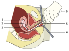
A vacuum aspiration abortion at eight weeks gestational age (six weeks after fertilization).
1: Amniotic sac
2: Embryo
3: Uterine lining
4: Speculum
5: Vacurette
6: Attached to a suction pump

Up to 15 weeks' gestation, suction-aspiration or vacuum aspiration are the most common surgical methods of induced abortion. Manual vacuum aspiration (MVA) consists of removing the fetus or embryo, placenta, and membranes by suction using a manual syringe, while electric vacuum aspiration (EVA) uses an electric pump. These techniques can both be used very early in pregnancy. MVA can be used up to 14 weeks but is more often used earlier in the U.S. EVA can be used later.

MVA, also known as "mini-suction" and "menstrual extraction", or EVA can be used in very early pregnancy when cervical dilation may not be required. Dilation and curettage (D&C) refers to opening the cervix (dilation) and removing tissue (curettage) via suction or sharp instruments. D&C is a standard gynecological procedure performed for a variety of reasons, including examination of the uterine lining for possible malignancy, investigation of abnormal bleeding, and abortion. The World Health Organization recommends sharp curettage only when suction aspiration is unavailable.

Dilation and evacuation (D&E), used after 12 to 16 weeks, consists of opening the cervix and emptying the uterus using surgical instruments and suction. D&E is performed vaginally and does not require an incision. Intact dilation and extraction (D&X) refers to a variant of D&E sometimes used after 18 to 20 weeks when removal of an intact fetus improves surgical safety or for other reasons.

Abortion may also be performed surgically by hysterotomy or gravid hysterectomy. Hysterotomy abortion is a procedure similar to a caesarean section and is performed under general anesthesia. It requires a smaller incision than a caesarean section and can be used during later stages of pregnancy. Gravid hysterectomy refers to removal of the whole uterus while still containing the pregnancy. Hysterotomy and hysterectomy are associated with much higher rates of maternal morbidity and mortality than D&E or induction abortion.

First trimester procedures can generally be performed using local anesthesia, while second trimester methods may require deep sedation or general anesthesia.

Labor induction abortion

In places lacking the necessary medical skill for dilation and extraction, or when preferred by practitioners, an abortion can be induced by first inducing labor and then inducing fetal demise if necessary. This is sometimes called "induced miscarriage". This procedure may be performed from 13 weeks gestation to the third trimester. Although it is very uncommon in the United States, more than 80% of induced abortions throughout the second trimester are labor-induced abortions in Sweden and other nearby countries.

Only limited data are available comparing labor-induced abortion with the dilation and extraction method. Unlike D&E, labor-induced abortions after 18 weeks may be complicated by the occurrence of brief fetal survival, which may be legally characterized as live birth. For this reason, labor-induced abortion is legally risky in the United States.

Other methods

Historically, a number of herbs reputed to possess abortifacient properties have been used in folk medicine. Among these are: tansy, pennyroyal, black cohosh, and the now-extinct silphium.

In 1978, one woman in Colorado died and another developed organ damage when they attempted to terminate their pregnancies by taking pennyroyal oil. Because the indiscriminant use of herbs as abortifacients can cause serious—even lethal—side effects, such as multiple organ failure, such use is not recommended by physicians.

Abortion is sometimes attempted by causing trauma to the abdomen. The degree of force, if severe, can cause serious internal injuries without necessarily succeeding in inducing miscarriage. In Southeast Asia, there is an ancient tradition of attempting abortion through forceful abdominal massage. One of the bas reliefs decorating the temple of Angkor Wat in Cambodia depicts a demon performing such an abortion upon a woman who has been sent to the underworld.

Reported methods of unsafe, self-induced abortion include misuse of misoprostol and insertion of non-surgical implements such as knitting needles and clothes hangers into the uterus. These and other methods to terminate pregnancy may be called "induced miscarriage". Such methods are rarely used in countries where surgical abortion is legal and available.

Safety

A likely illegal abortion flyer in South Africa

The health risks of abortion depend principally upon whether the procedure is performed safely or unsafely. The World Health Organization (WHO) defines unsafe abortions as those performed by unskilled individuals, with hazardous equipment, or in unsanitary facilities. Legal abortions performed in the developed world are among the safest procedures in medicine. In the United States as of 2012, abortion was estimated to be about 14 times safer for women than childbirth. CDC estimated in 2019 that US pregnancy-related mortality was 17.2 maternal deaths per 100,000 live births, while the US abortion mortality rate is 0.7 maternal deaths per 100,000 procedures. In the UK, guidelines of the Royal College of Obstetricians and Gynaecologists state that "Women should be advised that abortion is generally safer than continuing a pregnancy to term." Worldwide, on average, abortion is safer than carrying a pregnancy to term. A 2007 study reported that "26% of all pregnancies worldwide are terminated by induced abortion," whereas "deaths from improperly performed [abortion] procedures constitute 13% of maternal mortality globally." In Indonesia in 2000 it was estimated that 2 million pregnancies ended in abortion, 4.5 million pregnancies were carried to term, and 14-16 percent of maternal deaths resulted from abortion.

In the US from 2000 to 2009, abortion had a mortality rate lower than plastic surgery, lower or similar to running a marathon, and about equivalent to traveling 760 miles (1,220 km) in a passenger car. Five years after seeking abortion services, women who gave birth after being denied an abortion reported worse health than women who had either first or second trimester abortions. The risk of abortion-related mortality increases with gestational age, but remains lower than that of childbirth. Outpatient abortion is as safe from 64 to 70 days' gestation as it before 63 days.

There is little difference in terms of safety and efficacy between medical abortion using a combined regimen of mifepristone and misoprostol and surgical abortion (vacuum aspiration) in early first trimester abortions up to 10 weeks gestation. Medical abortion using the prostaglandin analog misoprostol alone is less effective and more painful than medical abortion using a combined regimen of mifepristone and misoprostol or surgical abortion.

Vacuum aspiration in the first trimester is the safest method of surgical abortion, and can be performed in a primary care office, abortion clinic, or hospital. Complications, which are rare, can include uterine perforation, pelvic infection, and retained products of conception requiring a second procedure to evacuate. Infections account for one-third of abortion-related deaths in the United States. The rate of complications of vacuum aspiration abortion in the first trimester is similar regardless of whether the procedure is performed in a hospital, surgical center, or office. Preventive antibiotics (such as doxycycline or metronidazole) are typically given before abortion procedures, as they are believed to substantially reduce the risk of postoperative uterine infection; however, antibiotics are not routinely given with abortion pills. The rate of failed procedures does not appear to vary significantly depending on whether the abortion is performed by a doctor or a mid-level practitioner.

Complications after second trimester abortion are similar to those after first trimester abortion, and depend somewhat on the method chosen. The risk of death from abortion approaches roughly half the risk of death from childbirth the farther along a woman is in pregnancy; from one in a million before 9 weeks gestation to nearly one in ten.
National Severe Storms Laboratory

From Wikipedia, the free encyclopedia

The National Severe Storms Laboratory (NSSL) is a National Oceanic and Atmospheric Administration (NOAA) weather research laboratory under the Office of Oceanic and Atmospheric Research. It is one of seven NOAA Research Laboratories (RLs).

NSSL studies weather radar, tornadoes, flash floods, lightning, damaging winds, hail, and winter weather out of Norman, Oklahoma, using various techniques and tools in their HWT, or Hazardous Weather Testbed. NSSL meteorologists developed the first doppler radar for the purpose of meteorological observation, and contributed to the development of the NEXRAD (WSR-88D).

NSSL has a partnership with the Cooperative Institute for Severe and High-Impact Weather Research and Operations (CIWRO) at the University of Oklahoma that enables collaboration and participation by students and visiting scientists in performing research. The Lab also works closely with the Storm Prediction Center (SPC) and the National Weather Service Norman Forecast Office, which are co-located at the National Weather Center (NWC) in Norman, Oklahoma. The NWC houses a combination of University of Oklahoma, NOAA and state organizations that work in collaboration.

History

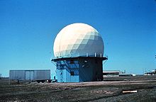
NSSL's first Doppler weather radar, the NSSL Doppler, located in Norman, Oklahoma. 1970s research using this radar led to NWS NEXRAD WSR-88D radar network.
 
The first tornado captured on May 24, 1973, by the NSSL Doppler weather radar and NSSL chase personnel. The tornado is here in its early stage of formation near Union City, Oklahoma

In 1962 a research team from the United States Weather Bureau's National Severe Storms Project (NSSP) moved from Kansas City, Missouri to Norman, Oklahoma, where, in 1956, the Cornell Aeronautical Laboratory had installed a 3 cm continuous-wave Doppler Weather Surveillance Radar-1957 (WSR-57). This radar was designed to detect very high wind speeds in tornadoes, but could not determine the distance to the tornadoes. In 1963, the Weather Radar Laboratory (WRL) was established in Norman and, in the following year, engineers modified the radar to transmit in pulses. The pulse-Doppler radar could receive data in between each transmit pulse, eliminating the need for two antennas and solving the distance problem.

In 1964, the remainder of the NSSP moved to Norman, where it merged with WRL and was renamed the National Severe Storms Laboratory (NSSL). Dr. Edwin Kessler became the first director. In 1969, NSSL obtained a surplus 10-cm pulse-Doppler radar from the United States Air Force. This radar was used to scan and film the complete life cycle of a tornado in 1973. By comparing the film with velocity images from the radar, the researchers found a pattern that showed the tornado beginning to form before it could be visually detected on the film. The researchers named this phenomenon the Tornado Vortex Signature (TVS). Research using this radar led to the concept that would later go on to become the NWS NEXRAD WSR-88D radar network. In 1973, the Laboratory commissioned a second Doppler weather radar, named the Cimarron radar, located 15 miles (24 km) west of Oklahoma City. This enabled NSSL to perform dual Doppler experiments while scanning storms with both radars simultaneously. A deliberate decision to collocate research with operations led the National Severe Storms Forecast Center to move from Kansas City to Norman in 1997, changing its name to the Storm Prediction Center. This move would allow for improved collaborations between NSSL and SPC. Some three years later in 2000, the first NOAA Hazardous Weather Testbed (HWT) Spring Experiment took place. This would become an annual event to evaluate operational and experimental models and algorithms with the NWS.

Organization

NSSL is organized into three primary divisions:

  • Forecast Research & Development Division
  • Radar Research & Development Division
  • Warning Research & Development Division

Forecast Research & Development

FACETs

Forecasting a Continuum of Environmental Threats (FACETs) serves as a broad-based framework and strategy to help focus and direct efforts related to next-generation science, technology and tools for forecasting environmental hazards. FACETS will address grid-based probabilistic threats, storm-scale observations and guidance, the forecaster, threat grid tools, useful output, effective response, and verification.

Warn-on-Forecast

The Warn-on-Forecast (WoF) research project aims to deliver a set of technologies for FACETs on a variety of space and time scales. WoF aims to create computer-model projections that accurately predict storm-scale phenomena such as tornadoes, large hail, and extremely localized rainfall. If Warn-on-Forecast is successful, forecasts likely could improve lead time by factors of 2 to 4 times.

NSSL-WRF

The Weather Research and Forecast (WRF) model is the product of a collaboration between the meteorological research and forecasting communities. Working at the interface between research and operations, NSSL scientists have been some of the main contributors to WRF development efforts and continue to provide operational implementation and testing of WRF. The NSSL WRF generates daily, real-time 1- to 36-hour experimental forecasts at a 4 km resolution of precipitation, lightning threat, and more.

WoF Tornado Threat Prediction

WoF Tornado Threat Prediction (WoF-TTP) is a research project to develop a 0–1 hour, 1-km resolution suite of high detail computer models to forecast individual convective storms and their tornadic potential. Target future average lead-time for tornado warnings via WoF-TTP is 40–60 minutes. The technology and science developed to achieve the WoF-TTP goal hopes to improve the prediction of other convective weather threats such as large hail and damaging winds.

NME

NSSL's Mesoscale Ensemble (NME) is an experimental analysis and short-range ensemble forecast system. These forecasts are designed to be used by forecasters as a 3-D hourly analysis of the environment.

Q2

The National Mosaic and Multi-sensor Quantitative Precipitation Estimation (NMQ) system uses a combination of observing systems ranging from radars to satellites on a national scale to produce precipitation forecasts. NMQ's prototype QPE products are also known as “Q2” - next-generation products combining the most effective multi-sensor techniques to estimate precipitation.

NEXRAD

NSSL scientists helped develop the Weather Surveillance Radar - 1988 Doppler (WSR-88D) radars, also known as NEXt-generation RADar (NEXRAD). Since the first Doppler weather radar became operational in Norman in 1974, NSSL has worked to extend its functionality, and proved to the NOAA National Weather Service (NWS) that Doppler weather radar was important as a nowcasting tool. The NWS now has a network of 158 NEXRADs.

Dual-Polarized Weather Radar (Dual-Pol)

Dual-polarized (dual-pol) radar technology is truly a NOAA-wide accomplishment. NSSL spent nearly 30 years researching and developing the technology. The National Weather Service (NWS) and NSSL developed the specifications for the modification, which was tested by engineers at the NWS Radar Operations Center. The NWS Warning Decision Training Branch provided timely and relevant training to all NWS forecasters who would be using the technology. The upgraded radars offer 14 new radar products to better determine the type and intensity of precipitation, and can confirm tornadoes are on the ground causing damage. Dual-pol is the most significant enhancement made to the nation's radar network since Doppler radar was first installed in the early 1990s.

Multi-Function Phased Array Radar (MPAR)

More than 350 FAA radars and by 2025, nearly 150 of the nation's Doppler weather radars will need to be either replaced or have their service life extended. Phased array radars have been used by the military for many years to track aircraft. NSSL's MPAR program is investigating to see if both the aircraft surveillance and weather surveillance functions can be combined into one radar. Combining the operational requirements of these various radar systems with a single technology solution would result in fiscal savings, and lesser resources with a greater end result.

Mobile Radar

NSSL researchers teamed up with several universities to build a mobile Doppler radar: a Doppler radar mounted on the back of a truck. The mobile radar can be driven into position as a storm is developing to scan the atmosphere at low levels, below the beam of WSR-88D radars. NSSL has used mobile radars to study tornadoes, hurricanes, dust storms, winter storms, mountain rainfall, and even biological phenomena.

Warning Research & Development

FACETs

Forecasting a Continuum of Environmental Threats (FACETs) serves as a broad-based framework and strategy to help focus and direct efforts related to next-generation science, technology and tools for forecasting environmental hazards. FACETs will address grid-based probabilistic threats, storm-scale observations and guidance, the forecaster, threat grid tools, useful output, effective response, and verification.

MYRORSS

The Multi-Year Reanalysis Of Remotely-Sensed Storms (MYRORSS – pronounced “mirrors”) NSSL and the National Climatic Data Center (NCDC) to reconstruct and evaluate numerical model output and radar products derived from 15 years of WSR-88D data over the coterminous U.S. (CONUS). The end result of this research will be a rich dataset with a diverse range of applications, including severe weather diagnosis and climatological information.

Hazardous Weather Testbed

NOAA's Hazardous Weather Testbed (HWT) is jointly managed by NSSL, the Storm Prediction Center (SPC) and the National Weather Service Oklahoma City/Norman Weather Forecast Office (OUN) on the University of Oklahoma campus inside the National Weather Center. The HWT is designed to accelerate the transition of promising new meteorological insights and technologies into advances in forecasting and warning for hazardous mesoscale weather events throughout the United States.

Threats in Motion

One of the new warning methodologies being tested in the NOAA Hazardous Weather Testbed is the “Threats-In-Motion” (TIM) concept. TIM warning grids update every minute and move continuously with the path of the storm. TIM has the advantage of providing useful lead times for all locations downstream of the hazards, and continually removes the warning from areas where threat has already passed.

FLASH

The Flooded Locations And Simulated Hydrographs Project (FLASH) was launched in early 2012 to improve the accuracy and timing of flash flood warnings. FLASH uses forecast models, geographic information, and real-time high-resolution, accurate rainfall observations from the NMQ/Q2 project to produce flash flood forecasts at 1-km/5-min resolution. FLASH project development continues to be an active collaboration between members of NSSL's Stormscale Hydrometeorology and Hydromodeling Groups, and the HyDROS Lab at the University of Oklahoma.

CI-FLOW

The Coastal and Inland Flooding Observation and Warning (CI-FLOW) project is a demonstration projection that predicts the combined effects of coastal and inland floods for coastal North Carolina. CI-FLOW captures the complex interaction between rainfall, river flows, waves, and tides and storm surge, and how they will impact ocean and river water levels. NSSL, with support from the NOAA National Sea Grant, leads the large and unique interdisciplinary team.

Decision Support

In an effort to support NWS forecasters, NSSL investigates methods and techniques to diagnose severe weather events more quickly and accurately.

AWIPS2

NSSL has more than ten NWS workstations—the Advanced Weather Interactive Processing System 2 (AWIPS2)—available for use in product evaluation. NSSL uses these AWIPS2 stations to test and demonstrate warning products and techniques that have been developed here that will be available in the NWS Forecast Office in the future.

WDSS-II

In the 1990s, NSSL developed the Warning Decision Support System, to enhance NWS warning capabilities. NSSL continues to work on the next generation WDSS-II (Warning Decision Support System: Integrated Information/NMQ), a tool that quickly combines data streams from multiple radars, surface and upper air observations, lightning detection systems, and satellite and forecast models. This improved and expanded system will eventually be moved to National Weather Service operations as the Multi-Radar Multi-Sensor (MRMS) system, and will automatically produce severe weather and precipitation products for improved decision-making capability within NOAA.

NSSL: On-Demand

NSSL: On-Demand is a web-based tool based on WDSS-II that helps confirm when and where severe weather occurred by mapping radar-detected circulations or hail on Google Earth satellite images. National Weather Service (NWS) forecast offices, including those affected by the 2011 Super Outbreak, use the images to plan post event damage surveys. Emergency responders use On-Demand to produce high-resolution street maps of affected areas, so they can more effectively begin rescue and recovery efforts and damage assessments.

NSSL Development Lab

NSSL's Development Lab includes four wall-mounted plasma screen displays and enough room for at least 10 workstations. A large round table occupies the middle of the room for lunchtime “brown bag” discussions and other meetings. Researchers, forecasters and developers are using the lab to evaluate new platforms and techniques in real-time as a team. The workstations in the lab can be quickly adapted for visualization and incorporation of unique data sources including dual-pol and phased array radars.

NMQ

NSSL created a powerful research and development tool for the creation of new techniques, strategies and applications to better estimate and forecast precipitation amounts, locations and types. The National Mosaic and Multi-sensor Quantitative Precipitation Estimation system (NMQ) uses a combination of observing systems ranging from radars to satellites on a national scale to produce precipitation forecasts.

MRMS

The MRMS system is the proposed operational version of the Warning Decision Support System - Integrated Information (WDSS-II) and the National Mosaic Quantitative Precipitation Estimation system.

MRMS is a system with automated algorithms that quickly and intelligently integrate data streams from multiple radars, surface and upper air observations, lightning detection systems, and satellite and forecast models. Numerous two-dimensional multiple-sensor products offer assistance for hail, wind, tornado, quantitative precipitation estimation forecasts, convection, icing, and turbulence diagnosis. The MRMS system was developed to produce severe weather and precipitation products for improved decision-making capability to improve severe weather forecasts and warnings, hydrology, aviation, and numerical weather prediction.

3D-VAR

A weather-adaptive three-dimensional variational data assimilation (3DVAR) system from NSSL/CIWRO automatically detects and analyzes supercell thunderstorms. The 3DVAR system uses data from the national WSR-88D radar network and NCEP's North American Mesoscale model product to automatically locate regions of thunderstorm activity. It is able to identify deep rotating updrafts that indicate a supercell thunderstorm at 1 km resolution every five minutes in these regions.

Field Research

NSSL participates in field research projects to collect weather data to increase knowledge about thunderstorm behavior and thunderstorm hazards.

Plains Elevated Convection At Night (PECAN) (2015)

PECAN was an extensive field project that focused on nighttime convection. PECAN was conducted across northern Oklahoma, central Kansas and into south-central Nebraska from 1 June to 15 July 2015.

VORTEX2 (2009-2010)

NSSL participated in the Verification of the Origins of Rotation in Tornadoes EXperiment 2009-2010, an extensive project studying small scale kinematics, atmospheric variables and when and why tornadoes form. The National Oceanic and Atmospheric Administration (NOAA) and National Science Foundation (NSF) supported more than 100 scientists, students and staff from around the world to collect weather measurements around and under thunderstorms that could produce tornadoes.

VORTEX (1994-1995)

The Verification of the Origins of Rotation in Tornadoes EXperiment was a two-year project designed to verify a number of ongoing questions about the causes of tornado formation. A new mobile Doppler radar was used and provided revolutionary data on several tornadic storms.

TOTO (1981-1987)

The TOtable TOrnado Observatory (TOTO), developed by NOAA Environmental Research Laboratory scientists, was a 55-gallon barrel outfitted with anemometers, pressure sensors, and humidity sensors, along with devices to record the data. In theory, a team would roll TOTO out of the back of the pickup in the path of a tornado, switch on the instruments, and get out of the way. Several groups tried to deploy TOTO over the years, but never took a direct hit. The closest TOTO ever came to success was in 1984 when it was sideswiped by the edge of a weak tornado and was knocked over. TOTO was retired in 1987.

Project Rough Rider (1980s)

Aircraft flew into thunderstorms to measure turbulence in the 1960s, 1970s and early 1980s. This data was combined with measurements of the intensity of the rain from nearby WSR-57s to understand how thunderstorm echoes and turbulence are related, with the goal of improving short-term turbulence forecasts.

Observation

Field Observing Systems

Mobile Mesonet

Scientists and technicians from NSSL and the University of Oklahoma built their first Mobile Mesonet (MM) vehicles, a.k.a. “probes,” in 1992. Probes are modified minivans with a suite of weather instruments mounted atop a roof rack and a complex of computer and communication equipment inside. NSSL scientists drive these through storms and storm environments to make measurements of temperature, pressure, humidity and wind.

2-Dimensional Video Distrometer (2DVD)

NSSL's 2DVD takes high speed video pictures, from two different angles, of anything falling from the sky through its viewing area (such as raindrops, hail or snow). It is used in polarimetric radar studies by measuring rain rate, drop shape and size distribution, and other parameters useful in narrowing down the accuracy of precipitation identification algorithms.

Portable Observation Device (POD)

NSSL has available small portable weather platforms with sensors that measure temperature, pressure, moisture, wind speed and direction, and an instrument called a Parsivel (PARticle, SIze, VELocity) disdrometer. These can be deployed quickly in the field, in and around thunderstorms.

Weather balloons

NSSL launches special research weather balloon systems into thunderstorms. Measurements from the sensor packages attached to the balloons provide data about conditions inside the storm where it has often proved too dangerous for research aircraft to fly.

Particle Size Image and Velocity Probe (PASIV)

PASIV is a balloon-borne instrument designed to capture images of water and ice particles as it is launched into, and rises up through, a thunderstorm. The instrument is flown as part of a “train” of other instruments connected one after another to a balloon. These other instruments measure electrical field strength and direction, and other variables such as temperature, dewpoint, pressure and winds.

Collaborative Lower Atmospheric Mobile Profiling System (CLAMPS)

NSSL has a mobile, trailer-based boundary layer profiling facility using commercially available sensors. CLAMPS contains a Doppler lidar, a multi-channel microwave radiometer, and an Atmospheric Emitted Radiance Interferometer (AERI). CLAMPS meets a NOAA/NWS operational and research need of for profiles of temperature, humidity, and winds near the surface of the earth.

Electric Field Meters (EFM)

NSSL's Field Observing Facilities and Support group (FOFS) is responsible for a device called an Electric Field Meter (EFM) that is attached, along with other instruments, to a special research balloon and launched into thunderstorms. As they are carried up through electrified storms, these EFMs are designed to measure the strength and direction of the electric fields that build up before lightning strikes occur. Data from this instrument helps researchers learn more about the electrical structure of storms.

Mobile laboratories

NSSL operates two mobile laboratories (custom built by an ambulance company) called NSSL6 and NSSL7, outfitted with computer and communication systems, balloon launching equipment, and weather instruments. These mobile labs can be deployed on a rapid basis to collect data or coordinate field operations.

Mobile Doppler radar

NSSL researchers with the University of Oklahoma built their first mobile Doppler radar in 1993. Current versions of mobile radars (for example, NSSL's NOXP) can be driven into positions very close to storms, observing details that are typically out of sight of the beam of more distant WSR-88D radars. NSSL has also used mobile radars to study tornadoes, hurricanes, dust storms, winter storms, mountain rainfall, and even biological phenomena.

Fixed Observing Systems

Oklahoma Lightning Mapping Array (OKLMA)

NSSL installed, operates and maintains the OKLMA. Thousands of points can be mapped for an individual lightning flash to reveal its location and the development of its structure. NSSL scientists hope to learn more about how storms produce intra-cloud and cloud-to-ground flashes and how each type is related to tornadoes and other severe weather.

Satellite

NSSL researchers are working on products that use GOES satellite data to identify rapidly growing clouds that might indicate a developing thunderstorm. They are also working on products that estimate wind shear and stability in the surrounding environment to forecast the future severity of the storm.

Boundary layer profilers

NSSL uses special instruments mounted on the top of the National Weather Center that can measure the thermodynamic properties of the lowest 1–2 km of the atmosphere (boundary layer). Researchers study the data to learn more about the structure of the boundary layer, shallow convective cloud processes, the interaction between clouds, aerosols, radiation, precipitation and the thermodynamic environment, mixed phase clouds, and more. Numerical models, such as those used for climate and weather prediction, have large uncertainties in all of these areas. Researchers also use these observations to improve our understanding and representation of these processes.

SHAVE

NSSL uses observations from people too! The mostly student-run NSSL/CIWRO Severe Hazards Analysis and Verification Experiment (SHAVE) collects hail, wind damage and flash flooding reports through phone surveys. SHAVE reports, when combined with the voluntary reports collected by the NWS, creates a unique and comprehensive database of severe and non-severe weather events and enhances climatological information about severe storm threats in the U.S.

mPING

Another way NSSL uses public observations is through the Meteorological Phenomena Identification Near the Ground (mPING) project. Volunteers can report on the precipitation that is reaching the ground at their location through mobile apps (iOS and Android). Researchers compare the reports of precipitation with what is detected by the dual-polarized radar data to refine precipitation identification algorithms.

Simulation

NSSL researchers have created a computer model that can simulate a thunderstorm to study how changes in the environment can affect its behavior. They also contribute to the development of the Weather Research and Forecast (WRF) model used in both research and NWS operations.

NSSL WRF

The Weather Research and Forecast (WRF) model is the product of a unique collaboration between the meteorological research and forecasting communities. Its level of sophistication is appropriate for cutting edge research, yet it operates efficiently enough to produce high resolution guidance for front-line forecasters in a timely manner. Working at the interface between research and operations, NSSL scientists have been major contributors to WRF development efforts and continue to provide leadership in the operational implementation and testing of WRF. The NSSL WRF generates daily, real-time 1- to 36-hour experimental forecasts at a 4 km resolution of precipitation, lightning threat, and more.

COMMAS

The NSSL COllaborative Model for Multiscale Atmospheric Simulation (COMMAS) is a 3D cloud model used to recreate thunderstorms for closer study. COMMAS is able to ingest radar data and lightning data from past events. Researchers use COMMAS to explore the microphysical structure and evolution of the storm and the relationship between microphysics and storm electricity. They also use COMMAS to simulate different phases of significant events, such as the early tornadic phase of the Greensburg, Kansas supercell that destroyed much of the town in 2004.

FLASH

The Flooded Locations And Simulated Hydrographs Project (FLASH) was launched in early 2012 largely in response to the demonstration and real-time availability of high-resolution, accurate rainfall observations from the NMQ/Q2 project. FLASH introduces a new paradigm in flash flood prediction that uses the NMQ forcing and produces flash flood forecasts at 1-km/5-min resolution through direct, forward simulation. The primary goal of the FLASH project is to improve the accuracy, timing, and specificity of flash flood warnings in the US, thus saving lives and protecting infrastructure. The FLASH team is composed of researchers and students who use an interdisciplinary and collaborative approach to achieve the goal.

Testbeds

Hazardous Weather Testbed

NOAA's Hazardous Weather Testbed (HWT) is jointly managed by NSSL, the Storm Prediction Center (SPC) and the National Weather Service Oklahoma City/Norman Weather Forecast Office (OUN) on the University of Oklahoma campus inside the National Weather Center. The HWT is designed to accelerate the transition of promising new meteorological insights and technologies into advances in forecasting and warning for hazardous mesoscale weather events throughout the United States.

National Weather Radar Testbed

NOAA's National Weather Radar Testbed (NWRT) is a phased array radar (PAR) being tested and evaluated in Norman, Oklahoma. The NWRT was established to demonstrate the potential to simultaneously perform aircraft tracking, wind profiling, and weather surveillance as a multi-function phased-array radar (MPAR). The advanced capabilities of the NWRT could lead to better warnings of severe weather.

Convective storm detection

From Wikipedia, the free encyclopedia

Convective storm detection is the meteorological observation, and short-term prediction, of deep moist convection (DMC). DMC describes atmospheric conditions producing single or clusters of large vertical extension clouds ranging from cumulus congestus to cumulonimbus, the latter producing thunderstorms associated with lightning and thunder. Those two types of clouds can produce severe weather at the surface and aloft.

The ability to discern the presence of deep moist convection in a storm significantly improves meteorologists' capacity to predict and monitor associated phenomena such as tornadoes, large hail, strong winds, and heavy rain leading to flash flooding. It relies on direct eyewitness observations, for example from storm spotters; and on remote sensing, especially weather radar. Some in situ measurements are used for direct detection as well, notably, wind speed reports from surface observation stations. It is part of the integrated warning system, consisting of prediction, detection, and dissemination of information on severe weather to users such as emergency management, storm spotters and chasers, the media, and the general public.

History

1960s radar technology (WSR-57) displaying supercells over Minneapolis – Saint Paul during the 1965 Twin Cities tornado outbreak

Rigorous attempts to warn of tornadoes began in the United States in the mid-20th century. Before the 1950s, the only method of detecting a tornado was by someone seeing it on the ground. Often, news of a tornado would reach a local weather office after the storm.

However, with the advent of weather radar, areas near a local office could get advance warning of severe weather. The first public tornado warnings were issued in 1950 and the first tornado watches and convective outlooks in 1952. In 1953 it was confirmed that hook echoes are associated with tornadoes. By recognizing these radar signatures, meteorologists could detect thunderstorms likely producing tornadoes from dozens of miles away.

Storm spotting

In the mid-1970s, the US National Weather Service (NWS) increased its efforts to train storm spotters to identify and report key features of storms which indicate severe hail, damaging winds, and tornadoes, as well as damage itself and flash flooding. The program was called Skywarn, and the spotters were local sheriff's deputies, state troopers, firefighters, ambulance drivers, amateur radio operators, civil defense (now emergency management) spotters, storm chasers, and ordinary citizens. When severe weather is anticipated, local weather service offices request that these spotters look out for severe weather, and report any tornadoes immediately, so that the office can issue a timely warning.

Usually, spotters are trained by the NWS on behalf of their respective organizations, and they report to them. The organizations activate public warning systems such as sirens and the Emergency Alert System, and forward the reports to the NWS, which does directly disseminate information and warnings through its NOAA Weather Radio All Hazards network. There are more than 230,000 trained Skywarn weather spotters across the United States.

In Canada, a similar network of volunteer weather watchers, called Canwarn, helps spot severe weather, with more than 1,000 volunteers.

In Europe, several nations are organizing spotter networks under the auspices of Skywarn Europe and the Tornado and Storm Research Organisation (TORRO) has maintained a network of spotters in the United Kingdom since the 1970s.

Storm spotters are needed because radar systems such as NEXRAD, and satellite images, do not detect tornadoes or hail, only indications that the storm has the potential. Radar and satellite data interpretation will usually give a warning before there is any visual evidence of such events, but ground truth from an observer can either verify the threat or determine it is not imminent. The spotter's ability to see what these remote sensing devices cannot is especially important as distance from a radar site increases, because the radar beam becomes progressively higher in altitude further away from the radar, due to curvature of Earth and the spread of the beam with distance. Therefore, when far from a radar, only precipitations and velocities high in the storm are observed. The important areas might not then be sampled or the resolution of the data might be poor. Also, some meteorological situations leading to tornadogenesis are not readily detectable by radar and on occasion tornado development may occur more quickly than radar can complete a scan and send the batch of data.

Visual evidence

A rotating wall cloud with rear flank downdraft clear slot evident to its left rear.

Storm spotters are trained to discern whether a storm seen from a distance is a supercell. They typically look to its rear, the main region of updraft and inflow. Under the updraft is a rain-free base, and the next step of tornadogenesis is the formation of a rotating wall cloud. The vast majority of intense tornadoes occur with a wall cloud on the backside of a supercell.

Evidence of a supercell comes from the storm's shape and structure, and cloud tower features such as a hard and vigorous updraft tower, a persistent and/or large overshooting top, a hard anvil (especially when backsheared against strong upper level winds), and a corkscrew look or striations. Under the storm and closer to where most tornadoes are found, evidence of a supercell and likelihood of a tornado includes inflow bands (particularly when curved) such as a "beaver tail", and other clues such as strength of inflow, warmth and moistness of inflow air, how outflow- or inflow-dominant a storm appears, and how far is the forward flank precipitation core from the wall cloud. Tornadogenesis is most likely at the interface of the updraft and forward flank downdraft, and requires a "balance" between the outflow and inflow.

Only wall clouds that rotate spawn tornadoes, and usually precede the tornado by five to thirty minutes. Rotating wall clouds are the visual manifestation of a mesocyclone. Barring a low-level boundary, tornadogenesis is highly unlikely unless a rear flank downdraft occurs, which is usually visibly evidenced by evaporation of cloud adjacent to a corner of a wall cloud. A tornado often occurs as this happens or shortly after; first, a funnel cloud dips and in nearly all cases by the time it reaches halfway down, a surface swirl has already developed, signifying a tornado is on the ground before condensation connects the surface circulation to the storm. Tornadoes may also occur without wall clouds, under flanking lines, and on the leading edge. Spotters monitor all areas of a storm and their surroundings.

Radar

Today, most developed countries have a network of weather radars, which remains the main method of detecting signatures likely associated with tornadoes and other severe phenomenons as hail and downbursts. Radar is always available, in places and times where spotters are not, and can also see features that spotters cannot, in the darkness of night and processes hidden within the cloud as well as invisible processes outside the cloud.

Tornadoes

Doppler NEXRAD radar image of two mesocyclones with one supercell passing over Northern Michigan on July 3rd, 1999 at 23:41 UTC. Rotations is seen as small couplets of red (away) and green (toward) radial velocities. The thick circles represents 3D vortices which have been classified as mesocyclones near the ground by a detection algorithm. The left mesocyclone is associated with a tornado while to the right a larger area of rotation has developed.
 
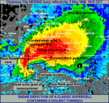
A classic hook echo. The tornado associated with this echo was part of the 1999 Oklahoma tornado outbreak. It reached F5 strength on the Fujita scale.
 
Vertical cross-section through a supercell exhibiting a BWER.

In short-term prediction and detection of tornadoes, meteorologists integrate radar data with reports from the field and knowledge of the meteorological environment. Radar analysis is augmented by automated detection systems called algorithms. Meteorologists first look at the atmospheric environment as well as changes thereof, and once storms develop, storm motion and interaction with the environment.

An early step in a storm organizing into a tornado producer is the formation of a weak echo region (WER) with a tilted updraft. This is an area within the thunderstorm where precipitation should be occurring but is "pulled" aloft by a very strong updraft. The weak echo region is characterized by weak reflectivity with a sharp gradient to strong reflectivity above it and partially surrounding the sides. The region of the precipitation lofted above the WER is the echo overhang consisting of precipitation particles diverging from the storm's summit that descend as they are carried downwind. Within this area, a bounded weak echo region (BWER) may then form above and enclosing the WER. A BWER is found near the top of the updraft and nearly or completely surrounded by strong reflectivity, and is indicative of a supercell capable of cyclic tornadogenesis. A mesocyclone may descend or a tornado may form in the lower level of the storm simultaneously as the mesocyclone forms.

In reflectivity (precipitation intensity) data, a tight echo gradient (particularly on the inflow area) and a fan shape generally indicate a supercell. A V-notch or "flying eagle echo" tend to be most pronounced with intense classic supercells, the type of supercell that produces most of the strongest, largest, and longest lived tornadoes. This is not to be confused with an inflow notch; which is a lower level indentation in the precipitation where there is little to no reflectivity, indicative of strong, organized inflow and a severe storm that is most likely a supercell. The rear inflow notch (or weak echo channel) occurs to the east or north of a mesocyclone and hook echo. Forward inflow notches also occur, particularly on high-precipitation supercells (HP) and quasi-linear convective systems (QLCS).

In the United States and a few other countries, Doppler capable weather radar stations are used. These devices are capable of measuring the radial velocity, including radial direction (towards or away from the radar) of the winds in a storm, and so can spot evidence of rotation in storms from more than a hundred miles (160 km) away. A supercell is characterized by a mesocyclone, which is usually first observed in velocity data as a tight, cyclonic structure in the middle levels of the thunderstorm. If it meets certain requirements of strength, duration, and vorticity, it may trip the mesocyclone detection algorithm (MDA). Tornadic signatures are indicated by a cyclonic inbound-outbound velocity couplet, where strong winds flowing in one direction and strong winds flowing in the opposite direction are occurring in very close proximity. The algorithm for this is the tornadic vortex signature (TVS) or the tornado detection algorithm (TDA). TVS is then an extremely strong mesocyclone found at very low level and extending over a deep layer of the thunderstorm, not the actual tornadic circulation. The TVS is, however, indicative of a likely tornado or an incipient tornado. The couplet and TVS typically precede tornado formation by 10–30 minutes but may occur at nearly the same time or precede the tornado by 45 minutes or more. Polarimetric radar can discern meteorological and nonmeteorological and other characteristics of hydrometeors that are helpful to tornado detection and nowcasting. Nonmeteorological reflectors co-located with a couplet, can confirm that a tornado has likely occurred and lofted debris. An area of high reflectivity, or debris ball, may also be visible on the end of the hook. Either the polarimetric data or debris ball are formally known as the tornado debris signature (TDS). The hook echo feature is formed as the RFD occludes precipitation around the mesocyclone and is also indicative of a probable tornado (tornadogenesis usually ensues shortly after the RFD reaches the surface).

After the implementation of the WSR-88D network in the U.S., the probability of detection of tornadoes increased substantially, the average lead time rose from four minutes to thirteen minutes, and a 2005 NOAA report estimates that as a result of improved warnings that there are 45 percent fewer fatalities and 40 percent fewer injuries annually. Dual-polarization radar, being implemented to the US NEXRAD network, may provide enhanced warning of tornadoes and severe winds and hail associated with the hook echo due to distinct precipitation drop characteristics. Polarimetric radar boosts precipitation observation and prediction, especially rainfall rates, hail detection, and distinguishing precipitation types. Proposed radar technologies, such as phased array and CASA, would further improve observations and forecasts by increasing the temporal and spatial resolution of scans in the former as well as providing low-level radar data over a wide area in the latter.

In certain atmospheric environments, wind profilers may also provide detection capabilities for tornadic activity.

Hail, downburst and downpour

Vertical cross-section of a thunderstorm at the top and VIL value of 63 kg/m2 with that cell at the bottom (red one), giving potential for hail, downpour, and/or downdraft

Hail forms in a very intense updraft in a supercell or a multicellular thunderstorm. As for tornadoes, BWER detection and a tilted updraft are indicative of that updraft but does not lead to predict hail. The presence of a hail spike in the reflectivity pattern is an important clue. It is an area of weak reflectivity extending away from the radar immediately behind a thunderstorm with hail. It is caused by radiation from the radar bouncing from hailstone to hailstone or the ground before being reflected back to the radar. The time delay between the backscattered radiation from the storm and the one with multiple paths causes the reflectivity from the hail to appear to come from a farther range than the actual storm. However, this artefact is visible mostly for extremely large hail.

What is needed is a knowledge of the water content in the thunderstorm, the freezing level and the height of the summit of the precipitation. One way of calculating the water content is to transform the reflectivities in rain rate at all levels in the clouds and to sum it up. This is done by an algorithm called Vertically integrated liquid, or VIL. This value represent the total amount of liquid water in the cloud that is available. If the cloud would rain out completely, it would be the amount of rain falling on the ground and one can estimate with VIL the potential for flash flood.

However, the reflectivities are greatly enhanced by hail and VIL is greatly overestimating the rain potential in presence of hail. On the other hand, National Weather Service meteorologists have found that the VIL density, that is to say VIL divided by the maximum height of the 18 dBZ in the cloud, is a good indicator of the presence of hail when it reach 3.5. This is a crude yes/no index and other algorithms have been developed involving VIL and the freezing level height. More recently, dual polarization of weather radar have shown promising direct detection of hail.

VIL can be used to estimate the potential for downburst, too. A convective downdraft is linked to three forces in the vertical, namely perturbation pressure gradient force, buoyancy force and precipitation loading. The pressure gradient force was neglected as it has significant effect only on the updraft in supercells. With this assumption and other simplifications (e.g. requiring the environment of the air parcel to be static on the time scale of the downdraft). The resulting momentum equation is integrated over height to yield the kinetic energy of the parcel on descending to the surface and is found to be the negative CAPE of a dry air parcel injected into the storm, plus de motion of the convective cell. S. R. Stewart, from NWS, has published in 1991 an equation relating VIL and the echo tops that give the potential for surface gust using this concept. This is a predictive result that gives a certain lead time. With the Doppler velocity data, the meteorologist can see the downdraft and gust fronts happening, but since this a small scale feature, detection algorithms have been developed to point convergence and divergence areas under a thunderstorm on the radar display.

Satellite imagery

Infrared weather satellite image at 23Z 7 April 2006 associated with a significant tornado outbreak in the eastern United States with arrows pointing to the enhanced-v signatures.

Most populated areas of the earth are now well covered by weather satellites, which aid in the nowcasting of severe convective and tornadic storms. These images are available in the visible and infrared domains. The infrared (IR: 10-13 µm) images permit estimation of the top height of the clouds, according to the air mass soundings of the day, and the visible (vis: 0.5-1.1 µm) ones will show the shape of the storms by its brightness and shadow produced. Meteorologists can extract information about the development stage and subsequent traits of thunderstorms by recognizing specific signatures in both domains. Visible imagery permits the most detailed imagery whereas infrared imagery has the advantage of availability at night. Sensors on satellites can also detect emissions from water vapor (WV: 6-7 µm), but mostly in the middle to upper levels of the troposphere, so thunderstorms are only seen after being well developed. It is, however, useful in convective storm prediction, as it illustrates the placement and movement of air masses and of moisture, as well as shortwaves and areas of vorticity and lifts.

Severe storms have a very strong updraft. The rising air parcels in that column accelerate and will overshoot the equilibrium level (EL) before being pulled back by negative buoyancy. This means the cloud tops will reach higher levels than the surrounding cloud in the updraft region. This overshooting top will be noticeable by a colder temperature region in the thunderstorm on infrared images. Another signature associated with this situation is the Enhanced-V feature where the cold cloud tops forming at the overshooting top fan out in a V shape as cloud matter is blown downwind at that level. Both features can be seen on visible satellite imagery, during daytime, by the shadows they cast on surrounding clouds.

In multicellular storms and squall lines, the mid-level jet stream is often intersecting the line and its dry air introduced into the cloud is negatively unstable. This results in drying of the cloudy air in the region where the jet plunge groundward. On the back edge of the line, this shows as clear notches where one can find stronger downdrafts at the surface. These kinds of lines often have a very characteristic undulating pattern caused by the interference of the gusts fronts coming from different parts of the line.

Finally, in any type of thunderstorm, the surface cold pool of air associated with the downdraft will stabilize the air and form a cloud-free area that will end along the gust front. This mesoscale front, when moving into a warm and unstable air mass, will lift it and cumulus clouds appear on satellite pictures. This line is likely the point of further convection and storms, especially if it coincides with fronts from other thunderstorms in the vicinity. One can notice it at the leading edge of a squall line, in the southeastern quadrant of a typical supercell (in the northern hemisphere), or different regions around other thunderstorms. They may also be visible as an outflow boundary hours or days after convection and can pinpoint areas of favored thunderstorm development, the possible direction of movement, and even likelihood for tornadoes. The speed of forward movement of the outflow boundary or gust front to some degree modulates the likelihood of tornadoes and helps determine whether a storm will be enhanced by its presence or the inflow be choked off thus weakening and possibly killing the storm. Thunderstorms may move along slow-moving or stationary outflow boundaries and tornadoes are more likely; whereas fast-moving gust fronts in many cases weaken thunderstorms after impact and are less likely to produce tornadoes—although brief tornadoes may occur at the time of impact. Fast-moving gust fronts may eventually decelerate and become slow-moving or stationary outflow boundaries with the characteristic "agitated area" of cumulus fields previously mentioned.

Lightning detection

Usually in conjunction with data sources such as weather radar and satellites, lightning detection systems are sometimes utilized to pinpoint where thunderstorms are occurring (and to identify lightning hazard). Currently, most lightning data provided in real-time is from terrestrial sources, specifically, networks of ground-based sensors, although airborne sensors are also in operation. Most of these only provide latitude & longitude, time, and polarity of cloud-to-ground strikes within a limited range. Increasing in sophistication and availability, and affording data for a very wide area, are satellite-based lightning detectors which initially included optical sensors indicating flash rates and horizontal location but now radio frequency receivers that can identify intra-cloud flashes with the addition of altitude, as well.

Lightning data is useful in suggesting intensity and organization of convective cells as well trends in thunderstorm activity (particularly growth, and to a lesser degree, decay). It is also useful in the early stages of thunderstorm development. This was especially true when visible and infrared satellite data was delayed, but continues to be useful in detecting thunderstorms in stages of development before there is a substantial radar signature or for areas where radar data is lacking. Coming advances in research and observations should improve forecasts of severe weather and increase warning time.

Personal lightning detection systems are also available, which may provide strike time, azimuth, and distance. In addition, lightning prediction systems are available and used mostly by parks and other outdoor recreational facilities, or meteorologists contracted to provide weather information for them.

Politics of Europe

From Wikipedia, the free encyclopedia ...