Search This Blog

Friday, April 10, 2020

Transit-oriented development

From Wikipedia, the free encyclopedia
 
The local government of Arlington County, Virginia encourages transit-oriented development within 14 to 12 mile (400 to 800 m) from the County's Washington Metro rapid transit stations, with mixed-use development, bikesharing and walkability.
 
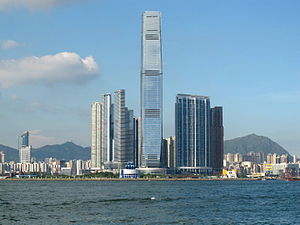
Union Square, a transit-oriented development centred on Kowloon Station, Hong Kong
 
In urban planning, a transit-oriented development (TOD) is a type of urban development that maximizes the amount of residential, business and leisure space within walking distance of public transport. It promotes a symbiotic relationship between dense, compact urban form and public transport use. In doing so, TOD aims to increase public transport ridership by reducing the use of private cars and by promoting sustainable urban growth.

A TOD typically includes a central transit stop (such as a train station, or light rail or bus stop) surrounded by a high-density mixed-use area, with lower-density areas spreading out from this center. A TOD is also typically designed to be more walkable than other built-up areas, through using smaller block sizes and reducing the land area dedicated to automobiles.

The densest areas of a TOD are normally located within a radius of ¼ to ½ mile (400 to 800 m) around the central transit stop, as this is considered to be an appropriate scale for pedestrians, thus solving the last mile problem.

Description

A Short History of Traffic Engineering
 
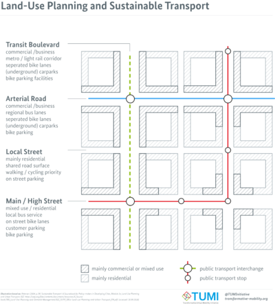
Land-Use Planning and Sustainable Transport.png

Many of the new towns created after World War II in Japan, Sweden, and France have many of the characteristics of TOD communities. In a sense, nearly all communities built on reclaimed land in the Netherlands or as exurban developments in Denmark have had the local equivalent of TOD principles integrated in their planning, including the promotion of bicycles for local use.

In the United States, a half-mile-radius circle has become the de facto standard for rail-transit catchment areas for TODs. A half mile (800 m) corresponds to the distance someone can walk in 10 minutes at 3 mph (4.8 km/h) and is a common estimate for the distance people will walk to get to a rail station. The half-mile ring is a little more than 500 acres (2.0 km2) in size.

Transit-oriented development is sometimes distinguished by some planning officials from "transit-proximate development" (see, e.g., comments made during a Congressional hearing) because it contains specific features that are designed to encourage public transport use and differentiate the development from urban sprawl. A few examples of these features include mixed-use development that will use transit at all times of day, excellent pedestrian facilities such as high quality pedestrian crossings, narrow streets, and tapering of buildings as they become more distant from the public transport node. Another key feature of transit-oriented development that differentiates it from "transit-proximate development" is reduced amounts of parking for personal vehicles.

Opponents of compact, or transit oriented development typically argue that Americans, and persons throughout the world, prefer low-density living, and that any policies that encourage compact development will result in substantial utility decreases and hence large social welfare costs. Proponents of compact development argue that there are large, often unmeasured benefits of compact development or that the American preference for low-density living is a misinterpretation made possible in part by substantial local government interference in the land market.

TOD in cities

Many cities throughout the world are developing TOD policy. Toronto, Portland, Montreal, San Francisco, and Vancouver among many other cities have developed, and continue to write policies and strategic plans, which aim to reduce automobile dependency and increase the use of public transit.

Latin America

Example of Curitiba's RIT in Praça do Japão

Curitiba, Brazil

One of the earliest and most successful examples of TOD is Curitiba, Brazil. Curitiba was organized into transport corridors very early on in its history. Over the years, it has integrated its zoning laws and transportation planning to place high-density development adjacent to high-capacity transportation systems, particularly its BRT corridors. Since the failure of its first rather grandiose city plan due to lack of funding, Curitiba has focused on working with economical forms of infrastructure, so it has arranged unique adaptations, such as bus routes (inexpensive infrastructure) with routing systems, limited access and speeds similar to subway systems. The source of innovation in Curitiba has been a unique form of participatory city planning that emphasizes public education, discussion and agreement.

Guatemala City, Guatemala

In an attempt to control rapid growth of Guatemala City, the long-time Mayor of Guatemala City Álvaro Arzú implemented a plan to control growth based on transects along important arterial roads and exhibiting transit-oriented development (TOD) characteristics. This plan adopted POT (Plan de Ordenamiento Territorial) aims to allow the construction of taller, mixed-use building structures right by large arterial roads; the buildings would gradually decrease in height and density the farther they are from arterial roads. This is simultaneously being implemented along with a bus rapid transit (BRT) system called Transmetro.

Mexico City, Mexico

Mexico City has battled pollution for years. Many attempts have been made to orient citizens towards public transportation. Expansion of metro line, both subway and bus, have been instrumental. Following the example of Curtiba, many bus-lines were created on many of Mexico City's most important streets. The bus-line has taken two lanes from cars to be used only by the bus-line, increasing the flow for bus transit.

The city has also made great attempts at increasing the number of bike lanes, including shutting down entire roads on certain days to be used only by bikers.

Car regulations have also increased in the city. New regulations prevent old cars from driving in the city, other cars from driving on certain days. Electric cars are allowed to be driven everyday and have free parking. Decreasing the public space allocated to cars and increasing regulations have become a great annoyance among daily car users. The city hopes to push people to use more public transport.

North America

Canada

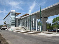
Marine Drive station in Vancouver on opening day (2009)
 
High-rises have since been built around the station (2018)
Edmonton, Alberta
Most of the suburban high rises were not along major rail lines like other cities until recently, when there has been incentive to do so. Century Park is a growing condo community in southern Edmonton at the south end of Edmonton's LRT. It will include low to high rise condos, recreational services, shops, restaurants, and a fitness centre. Edmonton has also had a transit-proximate development for some time in the northeastern suburbs at Clareview which includes a large park and ride, and low rise apartments among big box stores and associated power center parking. Edmonton is also looking into some new TODs in various parts of the city. In the northeast, there are plans to redevelop underutilized land at two sites around existing LRT, Fort Road and Stadium station. In the west, there is plans to have some medium density condos in the Glenora neighbourhood along a future LRT route as well as a TOD in the southeast in the Strathearn neighbourhood along the same future LRT on existing low rise apartments.
Montreal, Quebec
According to the Metropolitan Development and Planning Regulation of late 2011, 40% of new households will be built as TOD neighbourhoods.
Ottawa, Ontario
Ottawa's City Council has established transit-oriented development (TOD) priority areas in proximity to Ottawa's Light Rail Transit. These priority areas are a mix of moderate to high-density transit-supportive developments within a 600-metre walking distance of rapid transit stations.
Toronto, Ontario
Toronto has a longstanding policy of encouraging new construction along the route of its primary Yonge Street subway line. Most notable are the development of the Yonge and Eglinton area in the 1960s and 1970s; and the present development of the 2 km of the Yonge Street corridor north of Sheppard Avenue, which began in the late 1980s. In the period since 1997 alone the latter stretch has seen the appearance of a major new shopping centre and the building and occupation of over twenty thousand new units of condominium housing. Since the opening of the Sheppard subway line in 2002, there is a condominium construction boom along the route on Sheppard Avenue East between Yonge Street and Don Mills Road.
Vancouver, British Columbia
Vancouver has a strong history of creating new development around its SkyTrain lines and building regional town centres at major stations and transit corridors. Of note is the Metrotown area of the suburb of Burnaby, British Columbia near the Metrotown SkyTrain Station. The areas around stations have spurred the development of billions of dollars of high-density real estate, with multiple highrises near the many stations, prompting concerns about rapid gentrification.
Winnipeg, Manitoba
There is currently one TOD being built in Winnipeg beside the rapid transit corridor. It is known as The Yards at Fort Rouge, and was spearheaded by the developer Gem Equities. In phase two of the southwest rapid transit corridor, there will be four more TODs. This phase is an interesting example of the use of fine arts in parallel with transit planning, making several of the stations sites for public art related to the social history of the area.

United States

Arlington County, Virginia
Aerial view of Rosslyn-Ballston corridor in Arlington, Virginia. High density, mixed use development is concentrated within ¼–½ mile from the Rosslyn, Court House and Clarendon Washington Metro stations (shown in red), with limited density outside that area.
 
Street-level view of the area around the Ballston Metro Station — also in Arlington, Virginia. Note the mixed-use development (from left to right: ground floor retail under apartment building, office buildings, shopping mall (at the end of the street), apartment building, office building with ground floor retail), pedestrian oriented facilities including wide sidewalk, and bus stop facility in the center distance. Parking in this location is limited, relatively expensive, and located underground.
 
For over 30 years, the government has pursued a development strategy of concentrating much of its new development within 14 to 12 mile (400 to 800 m) from the County's Washington Metro rapid transit stations and the high-volume bus lines of Columbia Pike. Within the transit areas, the government has a policy of encouraging mixed-use and pedestrian- and transit-oriented development. Some of these "urban village" communities include: Rosslyn, Ballston, Clarendon, Courthouse, Pentagon City, Crystal City, Lyon Village, Shirlington, Virginia Square, and Westover
 
In 2002, Arlington received the EPA's National Award for Smart Growth Achievement for "Overall Excellence in Smart Growth" — the first ever granted by the agency.

In September 2010, Arlington County, Virginia, in partnership with Washington, D.C., opened Capital Bikeshare, a bicycle sharing system. By February 2011, Capital Bikeshare had 14 stations in the Pentagon City, Potomac Yard, and Crystal City neighborhoods in Arlington. Arlington County also announced plans to add 30 stations in fall 2011, primarily along the densely populated corridor between the Rosslyn and Ballston neighborhoods, and 30 more in 2012.
Aurora, Colorado
The city has developed within its plan as of 2007 standardization measures. For instance, streets' width has been set according to the position of the site.
New Jersey
New Jersey has become a national leader in promoting transit oriented development. The New Jersey Department of Transportation established the Transit Village Initiative in 1999, offering multi-agency assistance and grants from the annual $1 million fund to any municipality with a ready-to-go project specifying appropriate mixed land-use strategy, available property, station-area management, and commitment to affordable housing, job growth, and culture. Transit village development must also preserve the architectural integrity of historically significant buildings. Since 1999 the state has numerous Transit Village designations, which are in different stages of development:

Pleasantville (1999), Morristown (1999), Rutherford (1999), South Amboy (1999), South Orange (1999), Riverside (2001), Rahway (2002), Metuchen (2003), Belmar (2003), Bloomfield (2003), Bound Brook (2003), Collingswood (2003), Cranford (2003) Matawan (2003), New Brunswick (2005), Journal Square/Jersey City (2005), Netcong (2005), Midtown Elizabeth (2007), Burlington City (2007), Orange (2009), Montclair (2010), Somerville (2010), Linden (2010), West Windsor (2012), Dunellen (2012), Plainfield (2014), Park Ridge (2015), and Irvington (2015).
Pittsburgh, Pennsylvania
The East Liberty neighborhood is nearing completion of a $150 million Transit Oriented Development centered around the reconfigured East Liberty Station on the city's Martin Luther King Jr. East Busway. The development included improved access to the station with a new pedestrian bridge and pedestrian walkways that increase the effective walkshed of the station. The East Busway is a fixed guideway route that offers riders an 8-minute ride from East Liberty to Pittsburgh's Downtown.
Salt Lake City Metro Area, Utah
The Salt Lake City Metro Area has seen a strong proliferation of transit-oriented developments due to the construction of new transit lines within the Utah Transit Authority's TRAX, FrontRunner and streetcar lines. New developments in West Valley, Farmington, Murray, Provo, Kaysville, Sugarhouse and downtown Salt Lake City have seen rapid growth and construction despite the economic downturn. The population along the Wasatch Front has reached 2.5 million and is expected to grow 50% over the next two decades. At 29.8%, Utah's population growth more than doubled the population growth of the nation (13.2%), with a vast majority of this growth occurring along the Wasatch Front.

Transportation infrastructure has been vastly upgraded in the past decade as a result of the 2002 Olympic Winter Games and the need to support the growth in population. This has created a number of transit-oriented commercial and residential projects to be proposed and completed.
San Francisco Bay Area, California
The San Francisco Bay Area includes nine counties and 101 cities, including San Jose, San Francisco, Oakland and Fremont. Local and regional governments  encourage transit-oriented development to decrease traffic congestion, protect natural areas, promote public health and increase housing options. The region has designated Priority Development Areas and Priority Conservation Areas. Current population forecasts for the region predict that it will grow by 2 million people by 2035 due to both the natural birth rate and job creation, and estimate that 50% of this growth can be accommodated in Priority Development Areas through transit-oriented development.

Major transit village projects have been developed over the past 20 years at several stations linked to the Bay Area Rapid Transit (BART) system. In their 1996 book, Transit Villages in the 21st Century, Michael Bernick and Robert Cervero identified emerging transit villages at several BART stations, including Pleasant Hill / Contra Costa Centre, Fruitvale, Hayward and Richmond.[43] MacArthur Station is a relatively new development, with construction beginning in 2011 and scheduled for completion after 2019.

Asia and Oceania

Hong Kong

Sha Tin town centre, built around the Sha Tin railway station

Compared to other developed economies, the car ownership rate in Hong Kong is very low, and approximately 90% of all trips are made by public transport.

In the mid-20th century, no railway was built until an area was well developed. However, in recent decades, Hong Kong has started to have some TODs, where a railway is built simultaneously with residential development above or nearby, dubbed the "Rail plus Property" (R+P) Model. Examples include:

Malaysia

Bandar Malaysia is an upcoming development by 1Malaysia Development Berhad (1MDB).

Indonesia

Many TOD are now being constructed in Greater Jakarta metro area such as Citra Sentul Raya and Dukuh Atas TOD. TOD are also being constructed in cities like Surabaya, Medan, and Palembang.

Melbourne, Victoria

Chatswood Station in Sydney. Trains run through the integrated station, shopping and apartment complex

Melbourne, Victoria is expected to reach a population of 5 million by 2030 with the overwhelming majority of its residents relying on private automobiles. Since the turn of the century, sporadic efforts have been made by various levels of government to implement transit-oriented development principles. However, a lack of commitment to funding public transport infrastructure, resulting to overcrowding and amending zoning laws has dramatically slowed progress toward sustainable development for the city.

Milton, Queensland

Milton, an inner suburb of Brisbane, has been identified as Queensland's first transit-oriented development under the Queensland Government's South East Queensland Regional Plan. Milton railway station will undergo a multimillion-dollar revamp as part of the development of The Milton Residences to promote and encourage residents to embrace rail travel. This will include a new ticketing office, new public amenities, increased visibility across platforms and new and improved access points off Milton Road and Railway Terrace.

Sydney, New South Wales

The New South Wales state government has actively encouraged developments around stations on the Sydney Trains and Sydney Metro networks through its Priority Precincts plan. Several stations such as Chatswood, Burwood, Parramatta and Rhodes have large scale apartment developments built within close proximity within the past decade. New apartment and office tower developments along the future Sydney Metro stations are being planned as integrated developments with the stations themselves. Examples of this include Victoria Cross Station and Crows Nest Station whilst existing stations such as Castle Hill and Epping have also had intensified development.

Europe

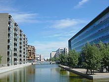
Karen Blixen Park, Ørestad (Copenhagen), Denmark

The term transit-oriented development, as a US-born concept, is rarely used in Europe, although many of the measures advocated in US transit-oriented development are also stressed in Europe. Many European cities have long been built around transit systems and there has thus often been little or no need to differentiate this type of development with a special term as has been the case in the US. An example of this is Copenhagen's Finger Plan from 1947, which embodied many transit-oriented development aspects and is still used as an overall planning framework today. Recently, scholars and technicians have taken interest in the concept, however.

Paris, France

Whereas the city of Paris has a centuries-long history, its main frame dates to the 19th century. The subway network was made to solve both linkage between the five main train stations and local transportation assets for citizens. The whole area of Paris City has metro stations no more than 500 metres apart. Recent bicycle and car rental systems (Velib and Autolib) also ease travel, in the very same way that TOD emphasizes. So do the new trams linking suburbs close to Paris proper, and tramline 3 around the edge of the city of Paris.

Stedenbaan, The Netherlands

In the Southern part of the Randstad a neighbourhood according to the principles of TOD will be built.

Equity and housing cost concerns

One criticism of transit-oriented development is that it has the potential to spur gentrification in low-income areas. In some cases, TOD can raise the housing costs of formerly affordable neighborhoods, pushing low- and moderate-income residents farther away from jobs and transit. When this happens, TOD projects can disrupt low-income neighborhoods.

When executed with equity in mind, however, TOD has the potential to benefit low- and moderate-income (LMI) communities: it can link workers to employment centers, create construction and maintenance jobs, and has the potential to encourage investment in areas that have suffered neglect and economic depression. Moreover, it is well recognized that neighborhood development restrictions, while potentially in the immediate neighborhood's best interest, contribute to regional undersupply of housing and drive up the cost of housing in general across a region. TOD reduces the overall cost of housing in a region by contributing to the housing supply, and therefore generally improves equity in the housing market. TOD also reduces transportation costs, which can have a greater impact on LMI households since they spend a larger share of their income on transportation relative to higher-income households. This frees up household income that can be used on food, education, or other necessary expenses. Low-income people are also less likely to own personal vehicles and therefore more likely to depend exclusively on public transportation to get to and from work, making reliable access to transit a necessity for their economic success.

Environmental impact of transport

From Wikipedia, the free encyclopedia 

Placard against fossil fuel transports, at the People's Climate March (2017).

The environmental impact of transport is significant because transport is a major user of energy, and burns most of the world's petroleum. This creates air pollution, including nitrous oxides and particulates, and is a significant contributor to global warming through emission of carbon dioxide. Within the transport sector, road transport is the largest contributor to global warming.

Environmental regulations in developed countries have reduced the individual vehicle's emission. However, this has been offset by an increase in the number of vehicles, and increased use of each vehicle (an effect known as the Jevons paradox). Some pathways to reduce the carbon emissions of road vehicles have been considerably studied. Energy use and emissions vary largely between modes, causing environmentalists to call for a transition from air and road to rail and human-powered transport, and increase transport electrification and energy efficiency.

The transportation sector is a major source of greenhouse gas emissions (GHGs) in the United States. An estimated 30 percent of national GHGs are directly attributable to transportation—and in some regions, the proportion is even higher. Transportation methods are the greatest contributing source of GHGs in the U.S., accounting for 47 percent of the net increase in total U.S. emissions since 1990.

Other environmental impacts of transport systems include traffic congestion and automobile-oriented urban sprawl, which can consume natural habitat and agricultural lands. By reducing transportation emissions globally, it is predicted that there will be significant positive effects on Earth's air quality, acid rain, smog and climate change.

The health impact of transport emissions is also of concern. A recent survey of the studies on the effect of traffic emissions on pregnancy outcomes has linked exposure to emissions to adverse effects on gestational duration and possibly also intrauterine growth.

As listed above direct impacts such as noise pollution and carbon monoxide emissions create direct and harmful effects on the environment, along with indirect impacts. The indirect impacts are often of higher consequence which leads to the misconception that it's the opposite since it is frequently understood that initial effects cause the most damage. For example, particulates which are the outcome of incomplete combustion done by an internal combustion engine, are not linked with respiratory and cardiovascular problems since they contribute to other factors not only to that specific condition. Even though the environmental impacts are usually listed individually there are also cumulative impacts. The synergetic consequences of transport activities. They take into account of the varied effects of direct and indirect impacts on an ecosystem. Climate change is the sum total impact of several natural and human-made factors. 15% of global CO2 emissions are attributed to the transport sector.

Mode

Overall GHG from Transport
 
Carbon Emissions Per Passenger
 
The following table compares the emissions of the different transport means for passenger transport in Europe:

Transport mean Passengers
average
Emissions
(g CO2/(km*pax))
Train 156 14
Small car 4 42
Big car 4 55
Bus 12.7 68
Motorbike 1.2 72
Small car 1.5 104
Big car 1.5 158
Plane 88 285
Ship 245
Bicycle 1 0

Aviation

Aviation emissions vary based on length of flight. For covering long distances, longer flights are a better investment of the high energy costs of take-off and landing than very short flights, yet by nature of their length inevitably use much more energy. CO
2
emissions from air travel range from 0.24 kg CO
2
per passenger mile (0.15 kg/km per passenger) for short flights down to 0.18 kg CO
2
per passenger mile (0.11 kg/km per passenger) for long flights. Researchers have been raising concern about the globally increasing hypermobility of society, involving frequent and often long distance air travel and the resulting environmental and climate impacts. This threatens to overcome gains made in the efficiency of aircraft and their operations. Climate scientist Kevin Anderson raised concern about the growing effect of air transport on the climate in a paper and a presentation in 2008. He has pointed out that even at a reduced annual rate of increase in UK passenger air travel and with the government's targeted emissions reductions in other energy use sectors, by 2030 aviation would be causing 70% of the UK's allowable CO
2
emissions. 

Worse, aircraft emissions at stratospheric altitudes have a greater contribution to radiative forcing than do emissions at sea level, due to effects several greenhouses gases in the emissions, apart from CO2. The other GHGs include methane (CH4), NOx which leads to ozone [O3], and water vapor. Overall, in 2005 the radiative forcing caused by aviation amounted to 4.9% of all human-caused radiative forcing on Earth's heat balance.

Road transport

Road traffic contributes to seed dispersal. How this compares to baseline dispersal in the habitat replaced by the roadway varies depending on the ecosystem.

Cycling

Cycling has a low carbon-emission and low environmental impact.

Cars

Unleaded gasoline has 8.91 kg and diesel has 10.15 kg of CO2 per gallon. CO2 emissions originating from ethanol are disregarded by international agreements however so gasoline containing 10% ethanol would only be considered to produce 8.02 kg of CO2 per gallon. The average fuel economy for new light-duty vehicles sold in the US of the 2017 model year was about 24.9 MPG giving around 0.36 kg of CO2 per mile. The Department of Transportation's MOBILE 6.2 model, used by regional governments to model air quality, uses a fleet average (all cars, old and new) of 20.3 mpg giving around 0.44 kg of CO2 per mile.

In Europe, the European Commission enforced that from 2015 all new cars registered shall not emit more than an average of 0.130 kg of CO2 per kilometre (kg CO2/km). The target is that by 2021 the average emissions for all new cars is 0.095 kg of CO2 per kilometre.

Buses

On average, inner city commuting buses emit 0.3 kg of CO
2
per passenger mile (0.18 kg/km per passenger), and long distance (>20 mi, >32 km) bus trips emit 0.08 kg of CO
2
per passenger mile (0.05 kg/km per passenger). Road and transportation conditions vary, so some carbon calculations add 10% to the total distance of the trip to account for potential traffic jams, detours, and pit-stops that may arise.

Rail

On average, commuter rail and subway trains emit 0.17 kg of CO
2
per passenger mile (0.11 kg/km per passenger), and long distance (>20 mi, >32 km) trains emit 0.19 kg of CO
2
per passenger mile (0.12 kg/km per passenger). Some carbon calculations add 10% to the total trip distance to account for detours, stop-overs, and other issues that may arise. Electric trains contributes relatively less to the pollution as pollution happens in the power plants which are lot more efficient than diesel driven engines. Generally electric motors even when accounting for transmission losses are more efficient than internal combustion engines with efficiency further improving through recuperative braking.

Infrastructure

Noise can be a direct impact on the natural environment as a result of railroads. Trains contain many different parts that have the potential to be thundering. Wheels, engines and non-aerodynamic cargo that actually vibrate the tracks can cause resounding sounds. Noise caused from directly neighboring railways has the potential to actually lessen value to property because of the inconveniences that railroads provide because of a close proximity. In order to combat unbearable volumes resulting from railways, US diesel locomotives are required to be quieter than 90 decibels at 25 meters away since 1979. This noise, however, has been shown to be harmless to animals, except for horses who will become skittish, that live near it.

Royal Gorge Bridge, Canon City, Colorado
 
Pollution is another direct result of railroads on the environment. Railroads can make the environment contaminated because of what trains carry. Railway pollution exists in all three states of matter: gaseous, liquid, and solid. Air pollution can occur from boxcars carrying materials such as iron ore, coal, soil, or aggregates and exposing these materials to the air. This can release nitrogen oxide, carbon monoxide, sulphur dioxide, or hydrocarbons into the air. Liquid pollution can come from railways contributing to a runoff into water supplies, like groundwater or rivers and can result from spillage of fuels like oil into water supplies or onto land or discharge of human waste in an unhealthy manner.

Visual Disruption of railroads is defined as a railway changing the way that a previously undisturbed, pristine sight of nature looks. When railways are built in wilderness areas, the environment is visually altered; a viewer will never be able to see the original scene again, and the builders of the railway often alter the landscape around the railway to allow it to ride. Frequent cuttings, embankments, dikes, and stilts are built which will change the way that landscape will look.

An example is the Royal Gorge Bridge in Canon City, Colorado. This bridge stands 955 feet above the Arkansas River and stretches 1,258 feet across. This bridge that now uses aerial trams is an unforgettable part of this Colorado landscape

Shipping

The fleet emission average for delivery vans, trucks and big rigs is 10.17  kg CO
2
per gallon of diesel consumed. Delivery vans and trucks average about 7.8 mpg (or 1.3 kg of CO
2
per mile) while big rigs average about 5.3 mpg (or 1.92 kg of CO
2
per mile).

Ballast water discharge from other sides of the world cause a certain type of pollution different from an emission type pollution as it introduces invasive species that can cause domestic species to go extinct.
 
Discharges of sewage into our water bodies can come from many sources, including wastewater treatment facilities, runoff from livestock operations, and vessels. These discharges have the potential to impair water quality, adversely affecting aquatic environments and increasing the risks to human health. While sewage discharges have potentially wide-ranging impacts on all aquatic environments, the impacts may be especially problematic in marinas, slow-moving rivers, lakes and other bodies of water with low flushing rates. Environmentally this creates invasive species that often drive other species to their extinction and cause harm to the environment and local businesses.

Emissions from ships have a much more significant environmental impacts; many ships go internationally from port to port and are not seen for weeks, contributing to air and water pollution on its voyage. Emission of greenhouse gases displaces the amount of gas that allows for UV-rays through the ozone. Sulfur and nitrogen compounds emitted from ship will oxidize in the atmosphere to form sulfate and nitrate. Emissions of nitrogen oxides, carbon monoxide, and volatile organic compounds (VOC) will lead to enhanced surface ozone formation and methane oxidation, depleting the ozone. The effect of the international ship emission on the distribution of chemical compounds such as NOx, CO, O3, OH, SO2, HNO3, and sulfate is studied using a global chemical transport model (CTM), the Oslo CTM2. In particular, the large-scale distribution and diurnal variation of the oxidants and sulfur compounds are studied interactively. Meteorological data (winds, temperature, precipitation, clouds, etc.) used as input for the CTM calculations are provided by a weather prediction model.

Shipping Emissions Factors:

Mode of Transport kg of CO
2
per Ton-Mile
Air cargo 0.8063
Truck 0.1693
Train 0.1048
Sea freight 0.0403

The road haulage industry is contributing around 20% of the UK's total carbon emissions a year, with only the energy industry having a larger impact, at around 39%. Road haulage is a significant consumer of fossil fuels and associated carbon emissions – HGV vehicles account for almost 20 percent of total emissions.

Mitigation of environmental impact

Sustainable transport

Energy Efficiency of different Transport Modes.png

Sustainable transport is transport with either lower environmental impact per passenger, per distance or higher capacity. Typically sustainable transport modes are rail, bicycle and walking.

Road-rail parallel layout

Construction of the route through the Kösching forest, north of Ingolstadt, Germany, had a large environmental impact but with Road-Rail Parallel Layout this would be less than using multiple routes.
 
Road-Rail Parallel Layout is a design option to reduce the environmental impact of new transportation routes by locating railway tracks alongside a highway. In 1984 the ParisLyon high-speed rail route in France had about 14% parallel layout with the highway, and in 2002, 70% parallel layout was achieved with the Cologne–Frankfurt high-speed rail line.

When changing how we use the road systems and how they factor into the amount of pollution they contribute, using existing roads is key for changing the current layout of our road system. When deciding to construct mitigation work, steps should be taken to install permanent and temporary access roads as needed to support drilling/development and production phases of the project, but minimize the number and length of such roads. For drilling activities, using old or two-track road access rather than constructing a higher quality access road. Develop a traffic management plan for site access roads and for use of main public roads. Develop and implement measures to control off-highway vehicle traffic off of newly constructed access roads. Limit traffic to roads and portions of rights-of-way indicated specifically for the project. Instruct and require all personnel and contractors to adhere to speed limits to ensure safe and efficient traffic flow. Encourage project employees to carpool to work sites. Limit construction vehicle traffic on public roadways to off-peak commuting times to minimize impacts on local commuters. Restore roads to equal or better condition than before project construction after the heavy construction period is complete. Lastly, controlling dust along unsurfaced roads—especially near residences and farm fields—may help prevent mixture of plants that can lead to disputes over patents.

Involvement

Mitigation does not entirely involve large-scale changes such as road construction, but everyday people can contribute. Walking, cycling trips, short or non-commute trips, can be an alternate mode of transportation when traveling short or even long distances. A multi-modal trip involving walking, a bus ride, and bicycling may be counted solely as a transit trip. Economic evaluations of transportation investments often ignore the true impacts of increased vehicular traffic—incremental parking, traffic accidents, and consumer costs—and the real benefits of alternative modes of transport. Most travel models do not account for the negative impacts of additional vehicular traffic that result from roadway capacity expansion and overestimate the economic benefits of urban highway projects. Transportation planning indicators, such as average traffic speeds, congestion delays, and roadway level of service, measure mobility rather than accessibility.

Impact of e-commerce

Large retail corporations in the most recent years have focused their attention to eCommerce spending. As a result, many industries compete to get products and services in the hands of their consumers. In order to beat out competition, many of these corporations created incentives to make customers buy from their online store instead of another. The most popular incentive among customers turned out to be either free, fast, or 2- day shipping. While these shipping options get products and services to the hands of buyers at unbelievably fast rates than ever before, there a negative externalities to public roads and to climate change

E-Commerce businesses are incentivized to implement free, fast, or 2- day shipping because these programs almost always come with a membership program that consumers need to buy into in order to receive the benefit of no shipping charge. These membership programs are great at obtaining customer loyalty, as these customers tend to stay with the businesses, especially with one stop shop stores like Walmart, Target, Costco, or Amazon. If these E-Commerce stores do not provide enough delivery options, they lose in sales. A survey in 2016 by UPS shows that 46% of online shoppers abandoned a shopping cart due to a shipping time that was too long and that 1 and 3 online shoppers look at the speed of delivery from the marketplaces they buy from. Consumers are demanding the fast delivery of goods and services. AlixPartners LLP found that consumers expect to wait an average of 4.8 days for delivery, down from 5.5 days in 2012. And the share of those who are willing to wait more than five days has declined to 60% from 74% in four years.

E-commerce shopping can be seen as the best way to reduce one's carbon footprint. Yet, this is only true to some extent. Shopping online is less energy intensive than driving to a physical store location and then driving back home. This is because shipping can take advantage of economies of scale. However, these benefits are diminished when e-commerce stores package items separately or when customers buy items separately and do not take the time to one stop shop.  For large stores with a large online presence, they can have millions of customers opting for these shipping benefits. As a result, they are unintentionally increasing carbon emissions from not consolidating their purchases. Josué Velázquez-Martínez, a sustainable logistics professor at MIT notes that "if you are willing to wait a week for shipping, you just kill 20 trees instead of 100 trees." The only time shipping works in being less energy intensive is when customer do not choose rush delivery, which includes 2-day shipping. M. Sanjayan, the CEO of Conservation International, explains that getting your online purchase delivered at home in just two days puts more polluting vehicles on the road. In addition to standard shipping, consumers must be satisfied with their purchases so that they do not constantly returns items. By returning shipments on standard shipping, the positive contribution to environment is being taken back. In research done by Vox, they found in 2016 transportation overtook power plants as the top prouder of carbon dioxide emissions in the US for the first time since 1979. This environmental impact came from nearly a quarter of transportation trucks that either carry medium and heavy duty loads of merchandise; these trucks are often the ones doing e-commerce shipping.

This is the market for shipping pollution. The optimal quantity and the optimal tax per unit of pollution can be found at the intersection of MAC and MD. As the quantity of pollution decreases (emissions), the cost to decrease each marginal unit of pollution increases.
 
Since 2009, UPS deliveries have increased by 65%. With the increase in deliveries, there is a demand for trucks on the road, resulting in more carbon emissions in our atmosphere. More recently, there has been research to help combat greenhouse gas emission to the atmosphere with better traffic signals. These WiFi signals cut down on wait time at stop lights and reduce wasting fuel. These signals help automobiles adjust their velocity so that they can  increase their chances of getting through the light, smoothing travel patterns and obtaining fuel-economy benefits. These small adjustments result in big changes in fuel savings. The cities that have started implementing smart light technology such as San Jose, CA and Las Vegas, NV. Light technology has shown to save 15-20% in fuel savings. According to the United States Environmental Protection Agency, transportation is the second leading source of GHG emission behind electricity and project that by 2050 freight transportation emissions will pass passenger vehicle emissions. Another technological advancements is truck platooning, trucks are able to send signals to neighboring trucks about their speed. This communication between vehicles reduces congestion on the roads and reduce drag, increasing fuel savings by 10 to 20%.

With these tech implementations in major cities and towns, there is the ability to reach an optimal level of pollution given the rise of e-commerce shipments. The figure above illustrates that decreasing emissions would result in the equilibrium for the market of shipping population, which can be done by consolidating packages, light technology, or truck platooning.

Automobile dependency

From Wikipedia, the free encyclopedia
 
Vicious Cycle of Automobile Dependency.png
Traffic in Los Angeles

Automobile dependency or car dependency is the concept that some city layouts cause automobiles to be favoured over alternate forms of transportation, such as bicycles, public transit, and walking.

Overview

Cars per 1000 Inhabitants.png

In many modern cities automobiles are convenient and sometimes necessary to move easily. When it comes to automobile use, there is a spiralling effect where traffic congestion produces the 'demand' for more and bigger roads and removal of 'impediments' to traffic flow, such as pedestrians, signalised crossings, traffic lights, cyclists, and various forms of street-based public transit, such as streetcars (trams).

These measures make automobile use more pleasurable and advantageous at the expense of other modes of transport, so greater traffic volumes are induced. Additionally, the urban design of cities adjusts to the needs of automobiles in terms of movement and space. Buildings are replaced by parking lots. Open air shopping streets are replaced by enclosed shopping malls. Walk-in banks and fast-food stores are replaced by drive-in versions of themselves that are inconveniently located for pedestrians. Town centres with a mixture of commercial, retail and entertainment functions are replaced by single-function business parks, 'category-killer' retail boxes and 'multiplex' entertainment complexes, each surrounded by large tracts of parking.

These kinds of environments require automobiles to access them, thus inducing even more traffic onto the increased roadspace. This results in congestion, and the cycle above continues. Roads get ever bigger, consuming ever greater tracts of land previously used for housing, manufacturing and other socially and economically useful purposes. Public transit becomes less and less viable and socially stigmatised, eventually becoming a minority form of transportation. People's choices and freedoms to live functional lives without the use of the car are greatly reduced. Such cities are automobile dependent.

Automobile dependency is seen primarily as an issue of environmental sustainability due to the consumption of non-renewable resources and production of greenhouse gases responsible for global warming. It is also an issue of social and cultural sustainability. Like gated communities, the private automobile produces physical separation between people and reduces the opportunities for unstructured social encounter that is a significant aspect of social capital formation and maintenance in urban environments.

Negative externalities of automobile

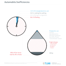
Automobile Inefficiencies

According to the Handbook on estimation of external costs in the transport sector made by the Delft University and which is the main reference in European Union for assessing the externalities of cars, the main external costs of driving a car are:

Addressing the issue

There are a number of planning and design approaches to redressing automobile dependency, known variously as New Urbanism, transit-oriented development, and smart growth. Most of these approaches focus on the physical urban design, urban density and landuse zoning of cities. Dr. Paul Mees, a transport planning academic formerly at the University of Melbourne, argues that investment in good public transit, centralised management by the public sector and appropriate policy priorities are more significant than issues of urban form and density.

There are, of course, many who argue against a number of the details within any of the complex arguments related to this topic, particularly relationships between urban density and transit viability, or the nature of viable alternatives to automobiles that provide the same degree of flexibility and speed. There is also research into the future of automobility itself in terms of shared usage, size reduction, roadspace management and more sustainable fuel sources.

Car-sharing is one example of a solution to automobile dependency. Research has shown that in the United States, services like Zipcar, have reduced demand by about 500,000 cars. In the developing world, companies like eHi, Carrot, Zazcar and Zoom have replicated or modified Zipcar's business model to improve urban transportation to provide a broader audience with greater access to the benefits of a car and provide"last-mile" connectivity between public transportation and an individual's destination. Car sharing also reduces private vehicle ownership.

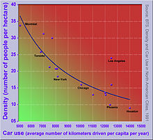
A diagram showing an inverse correlation between urban density and car use for selected North American cities

Urban sprawl and smart growth

Whether smart growth does or can reduce problems of automobile dependency associated with urban sprawl has been fiercely contested for several decades. The influential study in 1989 by Peter Newman and Jeff Kenworthy compared 32 cities across North America, Australia, Europe and Asia. The study has been criticised for its methodology, but the main finding, that denser cities, particularly in Asia, have lower car use than sprawling cities, particularly in North America, has been largely accepted, but the relationship is clearer at the extremes across continents than it is within countries where conditions are more similar.

Within cities, studies from across many countries (mainly in the developed world) have shown that denser urban areas with greater mixture of land use and better public transport tend to have lower car use than less dense suburban and exurban residential areas. This usually holds true even after controlling for socio-economic factors such as differences in household composition and income.

This does not necessarily imply that suburban sprawl causes high car use, however. One confounding factor, which has been the subject of many studies, is residential self-selection: people who prefer to drive tend to move towards low-density suburbs, whereas people who prefer to walk, cycle or use transit tend to move towards higher density urban areas, better served by public transport. Some studies have found that, when self-selection is controlled for, the built environment has no significant effect on travel behaviour. More recent studies using more sophisticated methodologies have generally rejected these findings: density, land use and public transport accessibility can influence travel behaviour, although social and economic factors, particularly household income, usually exert a stronger influence.

The paradox of intensification

Reviewing the evidence on urban intensification, smart growth and their effects on automobile use, Melia et al. (2011) found support for the arguments of both supporters and opponents of smart growth. Planning policies that increase population densities in urban areas do tend to reduce car use, but the effect is a weak one, so doubling the population density of a particular area will not halve the frequency or distance of car use. 

These findings led them to propose the paradox of intensification:
  • All other things being equal, urban intensification which increases population density will reduce per capita car use, with benefits to the global environment, but will also increase concentrations of motor traffic, worsening the local environment in those locations where it occurs.
At the citywide level, it may be possible, through a range of positive measures to counteract the increases in traffic and congestion that would otherwise result from increasing population densities: Freiburg im Breisgau in Germany is one example of a city which has been more successful in reducing automobile dependency and constraining increases in traffic despite substantial increases in population density.

This study also reviewed evidence on the local effects of building at higher densities. At the level of the neighbourhood or individual development, positive measures (like improvements to public transport) will usually be insufficient to counteract the traffic effect of increasing population density.
This leaves policy-makers with four choices:
  • intensify and accept the local consequences
  • sprawl and accept the wider consequences
  • a compromise with some element of both
  • or intensify accompanied by more direct measures such as parking restrictions, closing roads to traffic and carfree zones.

Car-free movement

From Wikipedia, the free encyclopedia
 
San Francisco Critical Mass in 2005.
 
The car-free movement is a broad, informal, emergent network of individuals and organizations, including social activists, urban planners, transportation engineers and others, brought together by a shared belief that large and/or high-speed motorized vehicles (cars, trucks, tractor units, motorcycles, etc.) are too dominant in most modern cities. The goal of the movement is to create places where motorized vehicle use is greatly reduced or eliminated, by converting road and parking space to other public uses and rebuilding compact urban environments where most destinations are within easy reach by other means, including walking, cycling, public transport, personal transporters, and mobility as a service.

Context

A quadracycle parked on a Canadian urban street between cars
 
Before the twentieth century, cities and towns were normally compact, containing narrow streets busy with human activity. In the early twentieth century, many of these settlements were adapted to accommodate the car with wider roads, more car parking spaces, and lower population densities, with space between urban buildings reserved for automotive use. Lower population densities meant urban sprawl with longer distances between places. The low cost of use brought traffic congestion which made older transport unattractive or impractical, and created the conditions for more traffic and sprawl; the car system was "increasingly able to 'drive' out competitors, such as feet, bikes, buses and trains". This process led to changes in urban form and living patterns that offered little opportunity for people without a car.

Some governments have responded with policies and regulations aimed at reversing auto dependency by increasing urban densities, encouraging mixed use development and infill, reducing space allocated to private cars, increasing walkability, supporting cycling and other alternative vehicles similar in size and speed, and public transport. Globally, urban planning is evolving in an effort to increase public transport and non-motorized transport modal shares and shift away from private transport oriented development. Cities like Hong Kong developed a highly integrated public transportation system which effectively reduced the use of private transport. In contrast with private automotive travel, car sharing, where people can easily rent a car for a few hours rather than own one, is emerging as an increasingly important element for urban transportation.

Urban design

Passenger Capacity of different Transport Modes
 
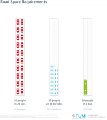
Road Space Requirements

Proponents of the car-free movement focus on both sustainable and public transport (bus, tram, etc.) options and on urban design, zoning, school placement policies, urban agriculture, telecommuting options, and housing developments that create proximity or access so that long distance transportation becomes less of a requirement of daily life.

New urbanism is an American urban design movement that arose in the early 1980s. Its goal has been to reform all aspects of real estate development and urban planning, from urban retrofits to suburban infill. New urbanist neighborhoods are designed to contain a diverse range of housing and jobs, and to be walkable. Other, more auto-oriented cities are also making incremental changes to provide transportation alternatives through Complete streets improvements.

World Squares for all is a scheme to remove much of the traffic from major squares in London, including Trafalgar Square and Parliament Square.

Car-free cities are, as the name implies, entire cities (or at least the inner parts thereof) which have been made entirely car-free.

Car-free zones are areas of a city or town where the use of cars is prohibited or greatly restricted.

To make the car-free zones/cities, (movable and/or stationary) traffic bollards and other barriers are often used to deny car access.

Living streets and complete streets prioritize the needs of users of the street as a whole over those of car drivers. They are designed to be shared by pedestrians, playing children, bicyclists, and low-speed motor vehicles.

The ring road around Amsterdam (shown in red). At exits of ring roads such as this, distribution centers can be set up.

Distribution centers allow easy restocking of supermarkets, outlet stores, restaurants, and more in city centers. They rely on tractor units to unload their cargo in the suburban distribution center. The products are then placed in a small truck (sometimes electrically powered), freight bicycle, or other vehicle to bridge the last mile to the destination in the city center. Besides offering advantages to the population (increased safety due to truck drivers having less blind spots, reduced noise/traffic, reduced tailpipe emissions, and more), it also offers financial advantage for the companies, as tractor units require a lot of time to bridge this last mile (they lack agility and consume much fuel in congested streets).

The method above however still doesn't reduce car use inside non-car-free city centers (customers often use cars to fetch their groceries or appliances from city stores, since they have so much storage space). This problem is solved by means of online food ordering systems, which allow customers to order online, and then have it delivered to their doorstep by the supermarket or store itself, through bicycle couriers (using freight bicycles), electric delivery robots and delivery vans. Delivery vans allow to take along more cargo and deliver to several customers on a same trip. These food ordering systems could provide for a smooth transition for those cities that wish to become car-free as it can reduce both personal car use and personal car demand in cities.

At the outskirts of towns, between the exits of the rings roads, and the car-free zones in the city center themselves, additional car parking lots can be added, generally in the form of underground car parks (to avoid it taking up surface space). Careful placement of these car-parking lots is needed though, ensuring that they are made far enough from the city centers (and closer to the ring roads) to avoid them attracting more cars to the city center. In some instances, near these car parking lots, Park and ride public transport (i.e. bus) stops are foreseen, or bicycle-sharing systems are present.

Community bicycle programs provide bicycles within an urban environment for short term use. The first successful scheme was in the 1960s in Amsterdam and can now be found in many other cities with 20,000 bicycles introduced to Paris in 2007 in the Vélib' scheme. Dockless bike share systems have recently appeared in the United States and provide more convenience for people wanting to rent a bike for a short time period.

Advocacy groups

The Campaign for Better Transport (formerly known as Transport2000) was formed in 1972 in Britain to challenge proposed cuts in the British rail network and since then has promoted public transport.

Car Free Walks is a UK-based website encouraging walkers to use public transport to reach the start and end of walks, rather than using a car.

Activism groups

Road protests in the United Kingdom rose to prominence in the early 1990s in response to a major road building program both in urban communities and also rural areas.

Reclaim the Streets, a movement formed in 1991 in London, "invaded" major roads, highway or freeway to stage parties. While this may obstruct the regular users of these spaces such as car drivers and public bus riders, the philosophy of RTS is that it is vehicle traffic, not pedestrians, who are causing the obstruction, and that by occupying the road they are in fact opening up public space.

In Flanders, the organization Fietsersbond has called upon the government to ban tractor units in city centers.

Critical Mass rides emerged in 1992 in San Francisco where cyclists take to the streets en masse to dominate the traffic, using the slogan "we are traffic." The ride was founded with the idea of drawing attention to how unfriendly the city was to bicyclists. The movement has grown to include events in major metropolitan cities around the world. 

The World Naked Bike Ride was born in 2001 in Spain with the first naked bike rides, which then emerged as the WNBR in 2004 a concept which rapidly spread through collaborations with many different activist groups and individuals around the world to promote bicycle transportation, renewable energy, recreation, walkable communities, and environmentally responsible, sustainable living.

Parking Days started in 2005 when REBAR, a collaborative group of creators, designers and activists based in San Francisco, transformed a metered parking spot into a small park complete with turf, seating, and shade and by 2007 there were 180 parks in 27 cities around the world.

Official events

Car Free Days are official events with the common goal of taking a fair number of cars off the streets of a city or some target area or neighborhood for all or part of a day, in order to give the people who live and work there a chance to consider how their city might look and work with significantly fewer cars. The first events were organized in Reykjavík (Iceland), Bath (UK) and La Rochelle (France) in 1995.

Ciclovía is a similar event in many cities that places a large emphasis on cycling as an alternative to auto travel. The event originated in Bogotá, Colombia in 1974. Now, Bogotá holds weekly ciclovías that turn the streets into giant car-free celebrations complete with stages set up in city parks with aerobics instructors, yoga teachers, and musicians leading people through various performances. The event has inspired similar celebrations globally.

In town, without my car! is an EU campaign and day every autumn (Northern Hemisphere) for an increased use of vehicles other than the car. It has since spread beyond the EU, and in 2004 more than 40 countries participated.

World Urbanism Day was founded in 1949 in Buenos Aires and is celebrated in more than 30 countries on four continents each November 8.

Towards Car-free Cities is the annual conference of the World Car-free Network and provides a focal point for diverse aspects of the emerging global car-free movement. The conference has been held in major cities around the world, including Portland, Oregon, United States in 2008 (its first time in North America), and has also been in Istanbul, Turkey; Bogota, Colombia; Budapest, Hungary; Berlin, Germany; Prague, Czech Republic; Timisoara, Romania; and Lyon, France. The conference series attempts to bridge the gap between many of the diverse people and organizations interested in reducing urban dependence on the automobile. 

Transportation Alternative's Annual Commuter Race pits a bicyclist against both a subway rider and a cab rider in a race from Queens to Manhattan. The Fifth Annual Commuter race took place in May 2009, where bicyclist Rachel Myers beat straphanger Dan Hendrick and cab rider Willie Thompson to make it the fifth year the contestant on the bicycle won. Myers took the 2009 title with a time of 20 minutes and 15 seconds to make the 4.2 mile trek from Sunnyside, Queens to Columbus Circle in Manhattan. Hendrick showed up 15 minutes later off the subway and Thompson arrived via cab nearly a half-hour after that. Transportation Alternatives is a group that "seeks to change New York City's transportation priorities to encourage and increase non-polluting, quiet, city-friendly travel and decrease—not ban—private car use. [They] seek a rational transportation system based on a 'Green Transportation Hierarchy,' which gives preference to modes of travel based on their benefits and costs to society. To achieve its goals, T.A. works in five areas: Bicycling, Walking and Traffic Calming, Car-Free Parks, Safe Streets and Sensible Transportation." The 2009 Commuter Race came on the heels of a Times Square traffic ban in NYC that drew national media attention.

Car-free development

Definitions and types

There are many areas of the world where people have always lived without cars, because no road access is possible, or none has been provided. In developed countries these include islands and some historic neighborhoods or settlements, the largest example being the canal city of Venice. The term carfree development implies a physical change - either new building or changes to an existing built area.
Melia et al. (2010) define car-free development as follows:
Car-free developments are residential or mixed use developments which:
  • Normally provide a traffic-free immediate environment, and:
  • Offer no parking or limited parking separated from the residence, and:
  • Are designed to enable residents to live without owning a car.
This definition (which they distinguish from the more common "low car development") is based mainly on experience in Northwestern Europe, where the movement for car-free development began. Within this definition three types are identified:
  • Vauban model
  • Limited Access model
  • Pedestrian zones with residential population

Vauban

Vauban, Freiburg, Germany is according to this definition, the largest car-free development in Europe, with over 5,000 residents. Whether it can be considered car-free is open to debate: many local people prefer the term "stellplatzfrei" - literally "free from parking spaces" to describe the traffic management system there. Vehicles are allowed down the residential streets at walking pace to pick up and deliver but not to park, although there are frequent infractions. Residents of the stellplatzfrei areas must sign an annual declaration stating whether they own a car or not. Car owners must purchase a place in one of the multi-storey car parks on the periphery, run by a council-owned company. The cost of these spaces – €17,500 in 2006, plus a monthly fee – acts as a disincentive to car ownership.

Limited access type

The more common form of car free development involves some sort of physical barrier, which prevents motor vehicles from penetrating into a car-free center. Melia et al. describe this as the "Limited Access" type. In some cases such as Stellwerk 60 in Cologne, there is a removable barrier, controlled by a residents' organizations. In others cases, such as in Waterwijk, vehicular access is only available from the exterior.

Pedestrian zones

Whereas the first two models apply to newly built car free developments, most pedestrianized areas have been retro-fitted. Pedestrian zones may be considered car-free developments where they include a significant population and a low rate of vehicle ownership per household. The largest example in Europe is Groningen, Netherlands which had a city centre population of 16,500 in 2008.

Benefits and problems

Reduction in one's carbon footprint for various actions

Several studies have been done on European car free developments. The most comprehensive was conducted in 2000 by Jan Scheurer. Other more recent studies have been made of specific car-free areas such as Vienna's Florisdorf car-free development.

The main benefits found for car free developments (summarized in Melia et al. 2010) found in the various studies are:
  • very low levels of car use, resulting in much less traffic on surrounding roads
  • high rates of walking and cycling
  • more independent movement and active play amongst children
  • less land taken for parking and roads - more available for green or social space
The main problems related to parking management. Where parking is not controlled in the surrounding area, this often results in complaints from neighbors about overspill parking.

Child abandonment

From Wikipedia, the free encyclopedia https://en.wikipedia.org/wiki/Child_abandonment ...