Search This Blog

Sunday, October 17, 2021

Atmospheric electricity

From Wikipedia, the free encyclopedia
 
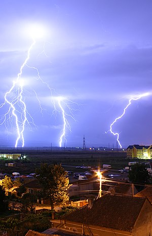
Cloud to ground lightning. Typically, lightning discharges 30,000 amperes, at up to 100 million volts, and emits light, radio waves, x-rays and even gamma rays. Plasma temperatures in lightning can approach 28,000 kelvins.

Atmospheric electricity is the study of electrical charges in the Earth's atmosphere (or that of another planet). The movement of charge between the Earth's surface, the atmosphere, and the ionosphere is known as the global atmospheric electrical circuit. Atmospheric electricity is an interdisciplinary topic with a long history, involving concepts from electrostatics, atmospheric physics, meteorology and Earth science.

Thunderstorms act as a giant battery in the atmosphere, charging up the electrosphere to about 400,000 volts with respect to the surface. This sets up an electric field throughout the atmosphere, which decreases with increase in altitude. Atmospheric ions created by cosmic rays and natural radioactivity move in the electric field, so a very small current flows through the atmosphere, even away from thunderstorms. Near the surface of the earth, the magnitude of the field is on average around 100 V/m.

Atmospheric electricity involves both thunderstorms, which create lightning bolts to rapidly discharge huge amounts of atmospheric charge stored in storm clouds, and the continual electrification of the air due to ionization from cosmic rays and natural radioactivity, which ensure that the atmosphere is never quite neutral.

History

Sparks drawn from electrical machines and from Leyden jars suggested to the early experimenters, Hauksbee, Newton, Wall, Nollet, and Gray, that lightning was caused by electric discharges. In 1708, Dr. William Wall was one of the first to observe that spark discharges resembled miniature lightning, after observing the sparks from a charged piece of amber.

Benjamin Franklin's experiments showed that electrical phenomena of the atmosphere were not fundamentally different from those produced in the laboratory, by listing many similarities between electricity and lightning. By 1749, Franklin observed lightning to possess almost all the properties observable in electrical machines.

In July 1750, Franklin hypothesized that electricity could be taken from clouds via a tall metal aerial with a sharp point. Before Franklin could carry out his experiment, in 1752 Thomas-François Dalibard erected a 40-foot (12 m) iron rod at Marly-la-Ville, near Paris, drawing sparks from a passing cloud. With ground-insulated aerials, an experimenter could bring a grounded lead with an insulated wax handle close to the aerial, and observe a spark discharge from the aerial to the grounding wire. In May 1752, Dalibard affirmed that Franklin's theory was correct.

Around June 1752, Franklin reportedly performed his famous kite experiment. The kite experiment was repeated by Romas, who drew from a metallic string sparks 9 feet (2.7 m) long, and by Cavallo, who made many important observations on atmospheric electricity. Lemonnier (1752) also reproduced Franklin's experiment with an aerial, but substituted the ground wire with some dust particles (testing attraction). He went on to document the fair weather condition, the clear-day electrification of the atmosphere, and its diurnal variation. Beccaria (1775) confirmed Lemonnier's diurnal variation data and determined that the atmosphere's charge polarity was positive in fair weather. Saussure (1779) recorded data relating to a conductor's induced charge in the atmosphere. Saussure's instrument (which contained two small spheres suspended in parallel with two thin wires) was a precursor to the electrometer. Saussure found that the atmospheric electrification under clear weather conditions had an annual variation, and that it also varied with height. In 1785, Coulomb discovered the electrical conductivity of air. His discovery was contrary to the prevailing thought at the time, that the atmospheric gases were insulators (which they are to some extent, or at least not very good conductors when not ionized). Erman (1804) theorized that the Earth was negatively charged, and Peltier (1842) tested and confirmed Erman's idea.

Several researchers contributed to the growing body of knowledge about atmospheric electrical phenomena. Francis Ronalds began observing the potential gradient and air-earth currents around 1810, including making continuous automated recordings. He resumed his research in the 1840s as the inaugural Honorary Director of the Kew Observatory, where the first extended and comprehensive dataset of electrical and associated meteorological parameters was created. He also supplied his equipment to other facilities around the world with the goal of delineating atmospheric electricity on a global scale. Kelvin's new water dropper collector and divided-ring electrometer were introduced at Kew Observatory in the 1860s, and atmospheric electricity remained a speciality of the observatory until its closure. For high-altitude measurements, kites were once used, and weather balloons or aerostats are still used, to lift experimental equipment into the air. Early experimenters even went aloft themselves in hot-air balloons.

Hoffert (1888) identified individual lightning downward strokes using early cameras. Elster and Geitel, who also worked on thermionic emission, proposed a theory to explain thunderstorms' electrical structure (1885) and, later, discovered atmospheric radioactivity (1899) from the existence of positive and negative ions in the atmosphere. Pockels (1897) estimated lightning current intensity by analyzing lightning flashes in basalt (c. 1900) and studying the left-over magnetic fields caused by lightning. Discoveries about the electrification of the atmosphere via sensitive electrical instruments and ideas on how the Earth's negative charge is maintained were developed mainly in the 20th century, with CTR Wilson playing an important part. Current research on atmospheric electricity focuses mainly on lightning, particularly high-energy particles and transient luminous events, and the role of non-thunderstorm electrical processes in weather and climate.

Description

Atmospheric electricity is always present, and during fine weather away from thunderstorms, the air above the surface of Earth is positively charged, while the Earth's surface charge is negative. This can be understood in terms of a difference of potential between a point of the Earth's surface, and a point somewhere in the air above it. Because the atmospheric electric field is negatively directed in fair weather, the convention is to refer to the potential gradient, which has the opposite sign and is about 100 V/m at the surface, away from thunderstorms. There is a weak conduction current of atmospheric ions moving in the atmospheric electric field, about 2 picoAmperes per square metre, and the air is weakly conductive due to the presence of these atmospheric ions.

Variations

Global daily cycles in the atmospheric electric field, with a minimum around 03 UT and peaking roughly 16 hours later, were researched by the Carnegie Institution of Washington in the 20th century. This Carnegie curve variation has been described as "the fundamental electrical heartbeat of the planet".

Even away from thunderstorms, atmospheric electricity can be highly variable, but, generally, the electric field is enhanced in fogs and dust whereas the atmospheric electrical conductivity is diminished.

Links with biology

The atmospheric potential gradient leads to an ion flow from the positively charged atmosphere to the negatively charged earth surface. Over a flat field on a day with clear skies, the atmospheric potential gradient is approximately 120 V/m. Objects protruding these fields, e.g. flowers and trees, can increase the electric field strength to several kilovolts per meter. These near-surface electrostatic forces are detected by organisms such as the bumblebee to navigate to flowers and the spider to initiate dispersal by ballooning. The atmospheric potential gradient is also thought to affect sub-surface electro-chemistry and microbial processes.

Near space

The electrosphere layer (from tens of kilometers above the surface of the earth to the ionosphere) has a high electrical conductivity and is essentially at a constant electric potential. The ionosphere is the inner edge of the magnetosphere and is the part of the atmosphere that is ionized by solar radiation. (Photoionization is a physical process in which a photon is incident on an atom, ion or molecule, resulting in the ejection of one or more electrons.)

Cosmic radiation

The Earth, and almost all living things on it, are constantly bombarded by radiation from outer space. This radiation primarily consists of positively charged ions from protons to iron and larger nuclei derived sources outside our solar system. This radiation interacts with atoms in the atmosphere to create an air shower of secondary ionising radiation, including X-rays, muons, protons, alpha particles, pions, and electrons. Ionization from this secondary radiation ensures that the atmosphere is weakly conductive, and the slight current flow from these ions over the Earth's surface balances the current flow from thunderstorms. Ions have characteristic parameters such as mobility, lifetime, and generation rate that vary with altitude.

Thunderstorms and lightning

The potential difference between the ionosphere and the Earth is maintained by thunderstorms, with lightning strikes delivering negative charges from the atmosphere to the ground.

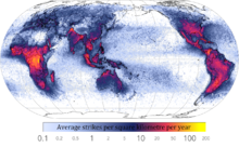
World map showing frequency of lightning strikes, in flashes per km² per year (equal-area projection). Lightning strikes most frequently in the Democratic Republic of the Congo. Combined 1995–2003 data from the Optical Transient Detector and 1998–2003 data from the Lightning Imaging Sensor.

Collisions between ice and soft hail (graupel) inside cumulonimbus clouds causes separation of positive and negative charges within the cloud, essential for the generation of lightning. How lightning initially forms is still a matter of debate: Scientists have studied root causes ranging from atmospheric perturbations (wind, humidity, and atmospheric pressure) to the impact of solar wind and energetic particles.

An average bolt of lightning carries a negative electric current of 40 kiloamperes (kA) (although some bolts can be up to 120 kA), and transfers a charge of five coulombs and energy of 500 MJ, or enough energy to power a 100-watt lightbulb for just under two months. The voltage depends on the length of the bolt, with the dielectric breakdown of air being three million volts per meter, and lightning bolts often being several hundred meters long. However, lightning leader development is not a simple matter of dielectric breakdown, and the ambient electric fields required for lightning leader propagation can be a few orders of magnitude less than dielectric breakdown strength. Further, the potential gradient inside a well-developed return-stroke channel is on the order of hundreds of volts per meter or less due to intense channel ionization, resulting in a true power output on the order of megawatts per meter for a vigorous return-stroke current of 100 kA .

If the quantity of water that is condensed in and subsequently precipitated from a cloud is known, then the total energy of a thunderstorm can be calculated. In an average thunderstorm, the energy released amounts to about 10,000,000 kilowatt-hours (3.6×10¹³ joule), which is equivalent to a 20-kiloton nuclear warhead. A large, severe thunderstorm might be 10 to 100 times more energetic.

Lightning sequence (Duration: 0.32 seconds)

Corona discharges

A depiction of atmospheric electricity in a Martian dust storm, which has been suggested as a possible explanation for enigmatic chemistry results from Mars

St. Elmo's Fire is an electrical phenomenon in which luminous plasma is created by a coronal discharge originating from a grounded object. Ball lightning is often erroneously identified as St. Elmo's Fire, whereas they are separate and distinct phenomena. Although referred to as "fire", St. Elmo's Fire is, in fact, plasma, and is observed, usually during a thunderstorm, at the tops of trees, spires or other tall objects, or on the heads of animals, as a brush or star of light.

Corona is caused by the electric field around the object in question ionizing the air molecules, producing a faint glow easily visible in low-light conditions. Approximately 1,000 – 30,000 volts per centimetre is required to induce St. Elmo's Fire; however, this is dependent on the geometry of the object in question. Sharp points tend to require lower voltage levels to produce the same result because electric fields are more concentrated in areas of high curvature, thus discharges are more intense at the end of pointed objects. St. Elmo's Fire and normal sparks both can appear when high electrical voltage affects a gas. St. Elmo's fire is seen during thunderstorms when the ground below the storm is electrically charged, and there is high voltage in the air between the cloud and the ground. The voltage tears apart the air molecules and the gas begins to glow. The nitrogen and oxygen in the Earth's atmosphere causes St. Elmo's Fire to fluoresce with blue or violet light; this is similar to the mechanism that causes neon signs to glow.

Earth-Ionosphere cavity

The Schumann resonances are a set of spectrum peaks in the extremely low frequency (ELF) portion of the Earth's electromagnetic field spectrum. Schumann resonance is due to the space between the surface of the Earth and the conductive ionosphere acting as a waveguide. The limited dimensions of the earth cause this waveguide to act as a resonant cavity for electromagnetic waves. The cavity is naturally excited by energy from lightning strikes.

Electrical system grounding

Atmospheric charges can cause undesirable, dangerous, and potentially lethal charge potential buildup in suspended electric wire power distribution systems. Bare wires suspended in the air spanning many kilometers and isolated from the ground can collect very large stored charges at high voltage, even when there is no thunderstorm or lightning occurring. This charge will seek to discharge itself through the path of least insulation, which can occur when a person reaches out to activate a power switch or to use an electric device.

To dissipate atmospheric charge buildup, one side of the electrical distribution system is connected to the earth at many points throughout the distribution system, as often as on every support pole. The one earth-connected wire is commonly referred to as the "protective earth", and provides path for the charge potential to dissipate without causing damage, and provides redundancy in case any one of the ground paths is poor due to corrosion or poor ground conductivity. The additional electric grounding wire that carries no power serves a secondary role, providing a high-current short-circuit path to rapidly blow fuses and render a damaged device safe, rather than have an ungrounded device with damaged insulation become "electrically live" via the grid power supply, and hazardous to touch.

Each transformer in an alternating current distribution grid segments the grounding system into a new separate circuit loop. These separate grids must also be grounded on one side to prevent charge buildup within them relative to the rest of the system, and which could cause damage from charge potentials discharging across the transformer coils to the other grounded side of the distribution network.
Saturday, October 16, 2021

Primordial soup

From Wikipedia, the free encyclopedia

Primordial soup, or prebiotic soup (also sometimes referred as prebiotic broth), is the hypothetical set of conditions present on the Earth around 4.0 to 3.7 billion years ago. It is a fundamental aspect to the heterotrophic theory of the origin of life, first proposed by Alexander Oparin in 1924, and John Burdon Sanderson Haldane in 1929.

Historical background

The notion that living beings originated from inanimate materials comes from the Ancient Greeks—the theory known as spontaneous generation. Aristotle in the 4th century BCE gave a proper explanation, writing:

So with animals, some spring from parent animals according to their kind, whilst others grow spontaneously and not from kindred stock; and of these instances of spontaneous generation some come from putrefying earth or vegetable matter, as is the case with a number of insects, while others are spontaneously generated in the inside of animals out of the secretions of their several organs.

— Aristotle, On the History of Animals, Book V, Part 1

Aristotle also states that it is not only that animals originate from other similar animals, but also that living things do arise and always have arisen from lifeless matter. His theory remained the dominant idea on origin of life (outside that of deity as a causal agent) from the ancient philosophers to the Renaissance thinkers in various forms. With the birth of modern science, experimental refutations emerged. Italian physician Francesco Redi demonstrated in 1668 that maggots developed from rotten meat only in a jar where flies could enter, but not in a closed-lid jar. He concluded that: omne vivum ex vivo (All life comes from life).

The experiment of French chemist Louis Pasteur in 1859 is regarded as the death blow to spontaneous generation. He experimentally showed that organisms (microbes) can not grow in sterilised water, unless it is exposed to air. The experiment won him the Alhumbert Prize in 1862 from the French Academy of Sciences, and he concluded: "Never will the doctrine of spontaneous generation recover from the mortal blow of this simple experiment."

Evolutionary biologists believed that a kind of spontaneous generation, but different from the simple Aristotelian doctrine, must have worked for the emergence of life. French biologist Jean-Baptiste de Lamarck had speculated that the first life form started from non-living materials. "Nature, by means of heat, light, electricity and moisture", he wrote in 1809 in Philosophie Zoologique (The Philosophy of Zoology), "forms direct or spontaneous generation at that extremity of each kingdom of living bodies, where the simplest of these bodies are found."

When English naturalist Charles Darwin introduced the theory of natural selection in his book On the Origin of Species in 1859, his supporters, such as a German zoologist Ernst Haeckel, criticised him for not using his theory to explain the origin of life. Haeckel wrote in 1862: "The chief defect of the Darwinian theory is that it throws no light on the origin of the primitive organism—probably a simple cell—from which all the others have descended. When Darwin assumes a special creative act for this first species, he is not consistent, and, I think, not quite sincere."

Although Darwin did not speak explicitly about the origin of life in On the Origin of Species, he did mention a "warm little pond" in a letter to Joseph Dalton Hooker dated February 1, 1871:

It is often said that all the conditions for the first production of a living being are now present, which could ever have been present. But if (and oh what a big if) we could conceive in some warm little pond with all sort of ammonia and phosphoric salts,—light, heat, electricity present, that a protein compound was chemically formed, ready to undergo still more complex changes, at the present such matter would be instantly devoured, or absorbed, which would not have been the case before living creatures were formed [...].

— Charles Darwin, Letter to Joseph Dalton Hooker on February 1, 1871

Heterotrophic theory

A coherent scientific argument was introduced by Soviet biochemist Alexander Oparin in 1924. According to Oparin, in the primitive Earth's surface, carbon, hydrogen, water vapour, and ammonia reacted to form the first organic compounds. Unbeknownst to Oparin, whose writing was circulated only in Russian, an English scientist John Burdon Sanderson Haldane independently arrived at a similar conclusion in 1929. It was Haldane who first used the term "soup" to describe the accumulation of organic material and water in the primitive Earth 

When ultra-violet light acts on a mixture of water, carbon dioxide, and ammonia, a vast variety of organic substances are made, including sugars and apparently some of the materials from which proteins are built up. [...] before the origin of life they must have accumulated till the primitive oceans reached the consistency of hot dilute soup.

— J. B. S. Haldane, The Origin of Life

Today the theory is variously known as the Heterotrophic theory, Heterotrophic origin of life theory or the Oparin-Haldane hypothesis. Biochemist Robert Shapiro has summarized the basic points of the theory in its "mature form" as follows: According to the heterotrophic theory, organic compounds were synthesized in the primitive Earth under prebiotic conditions. The mixture of such compounds with water under the atmosphere of the primitive Earth is referred as the prebiotic soup. There, life originated and the first forms of life were able use the organic molecules to survive and reproduce.

  1. Early Earth had a chemically reducing atmosphere.
  2. This atmosphere, exposed to energy in various forms, produced simple organic compounds ("monomers").
  3. These compounds accumulated in a "soup", which may have been concentrated at various locations (shorelines, oceanic vents etc.).
  4. By further transformation, more complex organic polymers – and ultimately life – developed in the soup.

Definitions

It is important to make the distinction between prebiotic and abiotic processes. While an abiotic process refers to anything that occurs without the presence of life, a prebiotic process refers to something that happens in the atmospheric and chemical conditions that the primitive Earth had about 4.2 billion years ago, and that preceded to the origin of life on the planet.

Oparin's theory

Alexander Oparin first postulated his theory in Russian in 1924 in a small pamphlet titled Proiskhozhdenie Zhizny (The Origin of Life). According to Oparin, the primitive Earth's surface had a thick red-hot liquid, composed of heavy elements such as carbon (in the form of iron carbide). This nucleus was surrounded by the lightest elements, i.e. gases, such as hydrogen. In the presence of water vapour, carbides reacted with hydrogen to form hydrocarbons. Such hydrocarbons were the first organic molecules. These further combined with oxygen and ammonia to produce hydroxy- and amino-derivatives, such as carbohydrates and proteins. These molecules accumulated on the ocean's surface, becoming gel-like substances and growing in size. They gave rise to primitive organisms (cells), which he called coacervates. In his original theory, Oparin considered oxygen as one of the primordial gases; thus the primordial atmosphere was an oxidising one. However, when he elaborated his theory in 1936 (in a book by the same title, and translated into English in 1938), he modified the chemical composition of the primordial environment as strictly reducing, consisting of methane, ammonia, free hydrogen and water vapour—excluding oxygen.

In his 1936 work, impregnated by a Darwinian thought that involved a slow and gradual evolution from the simple to the complex, Oparin proposed a heterotrophic origin, result of a long process of chemical and pre-biological evolution, where the first forms of life should have been microorganisms dependent on the molecules and organic substances present in their external environment. That external environment was the primordial soup.

The idea of a heterotrophic origin was based, in part, on the universality of fermentative reactions, which, according to Oparin, should have first appeared in evolution due to its simplicity. This was opposed to the idea, widely accepted at that time, that the first organisms emerged endowed with an autotrophic metabolism, which included photosynthetic pigments, enzymes and the ability to synthesize organic compounds from CO2 and H2O; for Oparin it was impossible to reconcile the original photosynthetic organisms with the ideas of Darwinian evolution.

From the detailed analysis of the geochemical and astronomical data known at that date, Oparin also proposed a primitive atmosphere devoid of O2 and composed of CH4, NH3 and H2O; under these conditions it was pointed out that the origin of life had been preceded by a period of abiotic synthesis and subsequent accumulation of various organic compounds in the seas of primitive Earth. This accumulation resulted in the formation of a primordial broth containing a wide variety of molecules.

There, according to Oparin, a particular type of colloid, the coacervates, were formed due to the conglomeration of organic molecules and other polymers with positive and negative charges. Oparin suggested that the first living beings had been preceded by pre-cellular structures similar to those coacervates, whose gradual evolution gave rise to the appearance of the first organisms.

Like the coacervates, several of Oparin's original ideas have been reformulated and replaced; this includes, for example, the reducing character of the atmosphere on primitive Earth, the coacervates as a pre-cellular model and the primitive nature of glycolysis. In the same way, we now understand that the gradual processes are not necessarily slow, and we even know, thanks to the fossil record, that the origin and early evolution of life occurred in short geologic time lapses.

However, the general approach of Oparin's theory had great implications for biology, since his work achieved the transformation of the study of the origin of life from a purely speculative field to a structured and broad research program. Thus, since the second half of the twentieth century, Oparin's theory of the origin and early evolution of life has undergone a restructuring that accommodates the experimental findings of molecular biology, as well as the theoretical contributions of evolutionary biology.

A point of convergence between these two branches of biology and that has been perfectly incorporated into the heterotrophic origin theory is found in the RNA world hypothesis.

Haldane's theory

J.B.S. Haldane independently postulated his primordial soup theory in 1929 in an eight-page article "The origin of life" in The Rationalist Annual. According to Haldane the primitive Earth's atmosphere was essentially reducing, with little or no oxygen. Ultraviolet rays from the Sun induced reactions on a mixture of water, carbon dioxide, and ammonia. Organic substances such as sugars and protein components (amino acids) were synthesised. These molecules "accumulated till the primitive oceans reached the consistency of hot dilute soup." The first reproducing things were created from this soup.

As to the priority over the theory, Haldane accepted that Oparin came first, saying, "I have very little doubt that Professor Oparin has the priority over me."

Monomer formation

One of the most important pieces of experimental support for the "soup" theory came in 1953. A graduate student, Stanley Miller, and his professor, Harold Urey, performed an experiment that demonstrated how organic molecules could have spontaneously formed from inorganic precursors, under conditions like those posited by the Oparin-Haldane Hypothesis. The now-famous "Miller–Urey experiment" used a highly reduced mixture of gases—methane, ammonia and hydrogen—to form basic organic monomers, such as amino acids. This provided direct experimental support for the second point of the "soup" theory, and it is one of the remaining two points of the theory that much of the debate now centers.

Apart from the Miller–Urey experiment, the next most important step in research on prebiotic organic synthesis was the demonstration by Joan Oró that the nucleic acid purine base, adenine, was formed by heating aqueous ammonium cyanide solutions. In support of abiogenesis in eutectic ice, more recent work demonstrated the formation of s-triazines (alternative nucleobases), pyrimidines (including cytosine and uracil), and adenine from urea solutions subjected to freeze-thaw cycles under a reductive atmosphere (with spark discharges as an energy source).

Further transformation

The spontaneous formation of complex polymers from abiotically generated monomers under the conditions posited by the "soup" theory is not at all a straightforward process. Besides the necessary basic organic monomers, compounds that would have prohibited the formation of polymers were formed in high concentration during the Miller–Urey and Oró experiments. The Miller experiment, for example, produces many substances that would undergo cross-reactions with the amino acids or terminate the peptide chain.

Friday, October 15, 2021

Geography of Tibet

From Wikipedia, the free encyclopedia
Jump to navigation Jump to search

The geography of Tibet consists of the high mountains, lakes and rivers lying between Central, East and South Asia. Traditionally, Western (European and American) sources have regarded Tibet as being in Central Asia, though today's maps show a trend toward considering all of modern China, including Tibet, to be part of East Asia. Tibet is often called "the roof of the world," comprising tablelands averaging over 4,950 metres above the sea with peaks at 6,000 to 7,500 m, including Mount Everest, on the border with Nepal.

Description

It is bounded on the north and east by the Central China Plain, on the west by the Kashmir Region of India and on the south by Nepal, India and Bhutan. Most of Tibet sits atop a geological structure known as the Tibetan Plateau, which includes the Himalaya and many of the highest mountain peaks in the world.

High mountain peaks include Changtse, Lhotse, Makalu, Gauri Sankar, Gurla Mandhata, Cho Oyu, Jomolhari, Gyachung Kang, Gyala Peri, Mount Kailash, Kawagebo, Khumbutse, Melungtse, Mount Nyainqentanglha, Namcha Barwa, Shishapangma and Yangra. Mountain passes include Cherko la and North Col. Smaller mountains include Mount Gephel and Gurla Mandhata.

Regions

Physically, Tibet may be divided into two parts, the "lake region" in the west and north-west, and the "river region", which spreads out on three sides of the former on the east, south, and west. The region names are useful in contrasting their hydrological structures, and also in contrasting their different cultural uses which is nomadic in the "lake region" and agricultural in the "river region". Despite its large size and mountainous nature, variation of climate across the Tibetan Plateau is more steady than abrupt. The "river region" has a subtropical highland climate with moderate summer rainfall averaging around 500 millimetres (20 in) per year, and daytime temperatures ranging from around 7 °C (45 °F) in winter to 24 °C (75 °F) in summer  though nights are as much as 15 °C (27 °F) cooler. Rainfall decreases steadily to the west, reaching only 110 millimetres (4.3 in) at Leh on the edge of this region, whilst temperatures in winter become steadily colder. On the south the "river region" is bounded by the Himalayas, on the north by a broad mountain system. The system at no point narrows to a single range; generally there are three or four across its breadth. As a whole the system forms the watershed between rivers flowing to the Indian Ocean – the Indus, Brahmaputra and Salween and its tributaries – and the streams flowing into the undrained salt lakes to the north.

The "river region" is characterized by fertile mountain valleys and includes the Yarlung Tsangpo River (the upper courses of the Brahmaputra) and its major tributary, the Nyang River, the Salween, the Yangtze, the Mekong, and the Yellow River. The Yarlung Tsangpo Canyon, formed by a horseshoe bend in the river where it flows around Namcha Barwa, is the deepest, and possibly longest canyon in the world. Among the mountains there are many narrow valleys. The valleys of Lhasa, Shigatse, Gyantse and the Brahmaputra are free from permafrost, covered with good soil and groves of trees, well irrigated, and richly cultivated.

The South Tibet Valley is formed by the Yarlung Zangbo River during its middle reaches, where it travels from west to east. The valley is approximately 1200 kilometers long and 300 kilometers wide. The valley descends from 4500 meters above sea level to 2800 meters. The mountains on either side of the valley are usually around 5000 meters high. Lakes here include Lake Paiku and Lake Puma Yumco.

The "lake region" extends from the Pangong Tso Lake in Ladakh, Lake Rakshastal, Yamdrok Lake and Lake Manasarovar near the source of the Indus River, to the sources of the Salween, the Mekong and the Yangtze. Other lakes include Dagze Co, Nam Co, and Pagsum Co. The lake region is an arid and wind-swept desert. This region is called the Chang Tang (Byang thang) or 'Northern Plateau' by the people of Tibet. It is some 1100 km (700 mi) broad, and covers an area about equal to that of France. Due to the extremely high mountain barriers it has a very arid alpine climate with annual precipitation around 100 millimetres (4 in) and possesses no river outlet. The mountain ranges are spread out, rounded, disconnected, separated by flat valleys. The country is dotted over with large and small lakes, generally salt or alkaline, and intersected by streams. Due to the presence of discontinuous permafrost over the Chang Tang, the soil is boggy and covered with tussocks of grass, thus resembling the Siberian tundra. Salt and fresh-water lakes are intermingled. The lakes are generally without outlet, or have only a small effluent. The deposits consist of soda, potash, borax and common salt. The lake region is noted for a vast number of hot springs, which are widely distributed between the Himalaya and 34° N., but are most numerous to the west of Tengri Nor (north-west of Lhasa). So intense is the cold in this part of Tibet that these springs are sometimes represented by columns of ice, the nearly boiling water having frozen in the act of ejection.

The effects of climate change

The Tibetan Plateau contains the world's third-largest store of ice. Qin Dahe, the former head of the China Meteorological Administration, said that the recent fast pace of melting and warmer temperatures will be good for agriculture and tourism in the short term; but issued a strong warning:

"Temperatures are rising four times faster than elsewhere in China, and the Tibetan glaciers are retreating at a higher speed than in any other part of the world." "In the short term, this will cause lakes to expand and bring floods and mudflows." "In the long run, the glaciers are vital lifelines for Asian rivers, including the Indus and the Ganges. Once they vanish, water supplies in those regions will be in peril."

Tibet during the last glacial period

Today Tibet is the most essential heating surface of the atmosphere. During the Last glacial period a c. 2,400,000 square kilometres (930,000 sq mi) ice sheet covered the plateau. This glaciation took place in correspondence to a lowering of the snowline by 1,200 metres (3,900 ft). For the Last Glacial Maximum this means a depression of the average annual temperature by 7 to 8 °C (13 to 14 °F) at a minor precipitation compared with that one of today.

Owing to this drop in temperature a supposed drier climate has partly been compensated with regard to the glacier feeding by a minor evaporation and an increased relative humidity. Due to its great extension this glaciation in the subtropics was the most important climatically foreign element on earth. With an albedo about 80-90% this ice area of Tibet has reflected an at least 4 times greater global radiation energy per surface into space than the further inland ices at a higher geographical latitude. At that time the most essential heating surface of the atmosphere  which at present, i.e. interglacially, is the Tibetan plateau  was the most important cooling surface.

The annual low-pressure area induced by heat above Tibet as a motor of the summer monsoon was lacking. The glaciation thus caused a breaking-off of the summer monsoon with all the global-climatic consequences, e.g. the pluvials in the Sahara, the expansion of the Thar desert, the heavier dust influx into the Arabian Sea etc., and also the downward shifting of the timber line and all forest-belts from the alpine-boreal forests as far down as to the semi-humid mediterranean forest which has replaced the Holocene monsoon-tropical forests on the Indian subcontinent. But also the movements of animals including the Javan Rusa far into South Asia are a consequence of this glaciation.

Despite heavy ablation caused by heavy insolation, the discharge of the glaciers into the Inner-Asian basins was sufficient for the creation of meltwater lakes in the Qaidam Basin, the Tarim Basin and the Gobi Desert. The drop in temperature (see above) was in favour of their development. Thus, the clay fraction produced by the ground scouring of the important glaciation was ready to be blown-out. The blow-out of the limnites and the Aeolian long-distance transport were connected to the katabatic winds. Accordingly, the Tibetan glaciation was the actual cause of the enormous loess production and the transport of the material into the Chinese middle- and lowlands continuing to the east. During the Ice Age the katabatic air current  the name 'winter monsoon' is not quite correct  blew all year round.

The enormous uplift of Tibet by around 10 mm/year measured by triangulations since the 19th century and confirmed by glaciogemorphological findings as well as by seismological investigations equals the uplift of the Himalaya. However, these amounts of uplift are far too important as to a primarily tectonic uplift of the high plateau which only takes place epirogenetically. Actually they can be understood the better by a superimposed glacioisostatic compensation movement of Tibet about 650 m.

An alternative view held by some scientists is that the glaciers on the Tibetan Plateau have remained restricted over the entire data published since 1974 in the literature referred to in Kuhle (2004), which are relevant as to the maximum ice extent.

Tibetan Plateau

From Wikipedia, the free encyclopedia
 
Tibetan Plateau
青藏高原 (Qīng–Zàng Gāoyuán, Qinghai–Tibet Plateau)
Himalaya composite.jpg
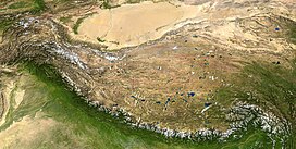
The Tibetan Plateau lies between the Himalayan range to the south and the Taklamakan Desert to the north. (Composite image)
Dimensions
Length2,500 km (1,600 mi)
Width1,000 km (620 mi)
Area2,500,000 km2 (970,000 sq mi)
Geography
Tibet and surrounding areas topographic map.png
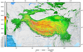
Tibetan Plateau and surrounding areas above 1600 m
LocationChina (Tibet, Qinghai, Western Sichuan, Northern Yunnan, Southern Xinjiang, Western Gansu)
India (Ladakh, Lahaul & Spiti), Pakistan (Gilgit Baltistan)
Nepal (Northern Nepal)
Bhutan
Tajikistan (Eastern Tajikistan)
Kyrgyzstan (Southern Kyrgyzstan)
Range coordinates33°N 88°ECoordinates: 33°N 88°E

The Tibetan Plateau (Tibetan: བོད་ས་མཐོ།, Wylie: bod sa mtho), also known as the Qinghai–Tibet Plateau or the Qing–Zang Plateau (Chinese: 青藏高原; pinyin: Qīng–Zàng Gāoyuán) or as the Himalayan Plateau in India, is a vast elevated plateau in Central Asia and East Asia, covering most of the Tibet Autonomous Region, most of Qinghai, Northwestern Yunnan, Western half of Sichuan, Southern Gansu provinces in Western China, the Indian regions of Ladakh and Lahaul and Spiti (Himachal Pradesh) as well as Bhutan. It stretches approximately 1,000 kilometres (620 mi) north to south and 2,500 kilometres (1,600 mi) east to west. It is the world's highest and largest plateau above sea level, with an area of 2,500,000 square kilometres (970,000 sq mi) (about five times the size of Metropolitan France). With an average elevation exceeding 4,500 metres (14,800 ft) and being surrounded by imposing mountain ranges that harbor the world's two highest summits, Mount Everest and K2, the Tibetan Plateau is often referred to as "the Roof of the World".

The Tibetan Plateau contains the headwaters of the drainage basins of most of the streams in surrounding regions. Its tens of thousands of glaciers and other geographical and ecological features serve as a "water tower" storing water and maintaining flow. It is sometimes termed the Third Pole because its ice fields contain the largest reserve of fresh water outside the polar regions. The impact of global warming on the Tibetan Plateau is of intense scientific interest.

Description

The Tibetan Plateau is surrounded by the massive mountain ranges of high-mountain Asia. The plateau is bordered to the south by the inner Himalayan range, to the north by the Kunlun Mountains, which separate it from the Tarim Basin, and to the northeast by the Qilian Mountains, which separate the plateau from the Hexi Corridor and Gobi Desert. To the east and southeast the plateau gives way to the forested gorge and ridge geography of the mountainous headwaters of the Salween, Mekong, and Yangtze rivers in northwest Yunnan and western Sichuan (the Hengduan Mountains). In the west, the curve of the rugged Karakoram range of northern Kashmir embraces the plateau. The Indus River originates in the western Tibetan Plateau in the vicinity of Lake Manasarovar.

Tibetan Buddhist stupa and houses outside the town of Ngawa, on the Tibetan Plateau.

The Tibetan Plateau is bounded in the north by a broad escarpment where the altitude drops from around 5,000 metres (16,000 ft) to 1,500 metres (4,900 ft) over a horizontal distance of less than 150 kilometres (93 mi). Along the escarpment is a range of mountains. In the west, the Kunlun Mountains separate the plateau from the Tarim Basin. About halfway across the Tarim the bounding range becomes the Altyn-Tagh and the Kunluns, by convention, continue somewhat to the south. In the 'V' formed by this split is the western part of the Qaidam Basin. The Altyn-Tagh ends near the Dangjin pass on the DunhuangGolmud road. To the west are short ranges called the Danghe, Yema, Shule, and Tulai Nanshans. The easternmost range is the Qilian Mountains. The line of mountains continues east of the plateau as the Qinling, which separates the Ordos Plateau from Sichuan. North of the mountains runs the Gansu or Hexi Corridor which was the main silk-road route from China proper to the West.

The plateau is a high-altitude arid steppe interspersed with mountain ranges and large brackish lakes. Annual precipitation ranges from 100 to 300 millimetres (3.9 to 11.8 in) and falls mainly as hail. The southern and eastern edges of the steppe have grasslands that can sustainably support populations of nomadic herdsmen, although frost occurs for six months of the year. Permafrost occurs over extensive parts of the plateau. Proceeding to the north and northwest, the plateau becomes progressively higher, colder, and drier, until reaching the remote Changtang region in the northwestern part of the plateau. Here the average altitude exceeds 5,000 metres (16,000 ft) and winter temperatures can drop to −40 °C (−40 °F). As a result of this extremely inhospitable environment, the Changthang region (together with the adjoining Kekexili region) is the least populous region in Asia and the third least populous area in the world after Antarctica and northern Greenland.

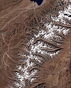
NASA satellite image of the south-eastern area of Tibetan Plateau. Brahmaputra River is in the lower right.

Geology and geological history

Yamdrok Lake is one of the three largest sacred lakes in Tibet.

The geological history of the Tibetan Plateau is closely related to that of the Himalayas. The Himalayas belong to the Alpine Orogeny and are therefore among the younger mountain ranges on the planet, consisting mostly of uplifted sedimentary and metamorphic rock. Their formation is a result of a continental collision or orogeny along the convergent boundary between the Indo-Australian Plate and the Eurasian Plate.

The collision began in the Upper Cretaceous period about 70 million years ago, when the north-moving Indo-Australian Plate, moving at about 15 cm (6 in) per year, collided with the Eurasian Plate. About 50 million years ago, this fast-moving Indo-Australian plate had completely closed the Tethys Ocean, the existence of which has been determined by sedimentary rocks settled on the ocean floor, and the volcanoes that fringed its edges. Since these sediments were light, they crumpled into mountain ranges rather than sinking to the floor. The Indo-Australian plate continues to be driven horizontally below the Tibetan Plateau, which forces the plateau to move upwards; the plateau is still rising at a rate of approximately 5 mm (0.2 in) per year.

Much of the Tibetan Plateau is of relatively low relief. The cause of this is debated among geologists. Some argue that the Tibetan Plateau is an uplifted peneplain formed at low altitude, while others argue that the low relief stems from erosion and infill of topographic depressions that occurred at already high elevations.

The current tectonics of the plateau is much debated. The two end-member models are the block model, in which the crust of the plateau is formed of several blocks with little internal deformation separated by major strike-slip faults. In the alternative continuum model, the plateau is affected by distributed deformation resulting from flow within the crust.

Environment

Typical landscape

The Tibetan Plateau supports a variety of ecosystems, most of them classified as montane grasslands. While parts of the plateau feature an alpine tundra-like environment, other areas feature monsoon-influenced shrublands and forests. Species diversity is generally reduced on the plateau due to the elevation and low precipitation. The Tibetan Plateau hosts the Tibetan wolf, and species of snow leopard, wild yak, wild donkey, cranes, vultures, hawks, geese, snakes, and water buffalo. One notable animal is the high-altitude jumping spider, that can live at elevations of over 6,500 metres (21,300 ft).

Ecoregions found on the Tibetan Plateau, as defined by the World Wide Fund for Nature, are as follows:

Human history

Pastoral nomads camping near Namtso.
 
Nomad camp near Tingri, Tibet. 1993

Nomads on the Tibetan Plateau and in the Himalayas are the remainders of nomadic practices historically once widespread in Asia and Africa. Pastoral nomads constitute about 40% of the ethnic Tibetan population. The presence of nomadic peoples on the plateau is predicated on their adaptation to survival on the world's grassland by raising livestock rather than crops, which are unsuitable to the terrain. Archaeological evidence suggests that the earliest human occupation of the plateau occurred between 30,000 and 40,000 years ago. Since colonization of the Tibetan Plateau, Tibetan culture has adapted and flourished in the western, southern, and eastern regions of the plateau. The northern portion, the Changtang, is generally too high and cold to support permanent population. One of the most notable civilizations to have developed on the Tibetan Plateau is the Tibetan Empire from the 7th century to the 9th century AD.

Impact on other regions

Role in monsoons

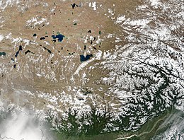
Natural-colour satellite image of the Tibetan Plateau

Monsoons are caused by the different amplitudes of surface temperature seasonal cycles between land and oceans. This differential warming occurs because heating rates differ between land and water. Ocean heating is distributed vertically through a "mixed layer" that may be 50 meters deep through the action of wind and buoyancy-generated turbulence, whereas the land surface conducts heat slowly, with the seasonal signal penetrating only a meter or so. Additionally, the specific heat capacity of liquid water is significantly greater than that of most materials that make up land. Together, these factors mean that the heat capacity of the layer participating in the seasonal cycle is much larger over the oceans than over land, with the consequence that the land warms and cools faster than the ocean. In turn, air over the land warms faster and reaches a higher temperature than does air over the ocean. The warmer air over land tends to rise, creating an area of low pressure. The pressure anomaly then causes a steady wind to blow toward the land, which brings the moist air over the ocean surface with it. Rainfall is then increased by the presence of the moist ocean air. The rainfall is stimulated by a variety of mechanisms, such as low-level air being lifted upwards by mountains, surface heating, convergence at the surface, divergence aloft, or from storm-produced outflows near the surface. When such lifting occurs, the air cools due to expansion in lower pressure, which in turn produces condensation and precipitation.

In winter, the land cools off quickly, but the ocean maintains the heat longer. The hot air over the ocean rises, creating a low-pressure area and a breeze from land to ocean while a large area of drying high pressure is formed over the land, increased by wintertime cooling. Monsoons are similar to sea and land breezes, a term usually referring to the localized, diurnal cycle of circulation near coastlines everywhere, but they are much larger in scale, stronger and seasonal. The seasonal monsoon wind shift and weather associated with the heating and cooling of the Tibetan plateau is the strongest such monsoon on Earth.

Glaciology: the Ice Age and at present

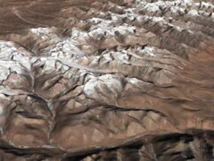
The Himalayas as seen from space looking south from over the Tibetan Plateau.

Today, Tibet is an important heating surface of the atmosphere. However, during the Last Glacial Maximum, an approximately 2,400,000 square kilometres (930,000 sq mi) ice sheet covered the plateau. Due to its great extent, this glaciation in the subtropics was an important element of radiative forcing. With a much lower latitude, the ice in Tibet reflected at least four times more radiation energy per unit area into space than ice at higher latitudes. Thus, while the modern plateau heats the overlying atmosphere, during the Last Ice Age it helped to cool it.

This cooling had multiple effects on regional climate. Without the thermal low pressure caused by the heating, there was no monsoon over the Indian subcontinent. This lack of monsoon caused extensive rainfall over the Sahara, expansion of the Thar Desert, more dust deposited into the Arabian Sea, and a lowering of the biotic life zones on the Indian subcontinent. Animals responded to this shift in climate, with the Javan rusa migrating into India.

In addition, the glaciers in Tibet created meltwater lakes in the Qaidam Basin, the Tarim Basin, and the Gobi Desert, despite the strong evaporation caused by the low latitude. Silt and clay from the glaciers accumulated in these lakes; when the lakes dried at the end of the ice age, the silt and clay were blown by the downslope wind off the Plateau. These airborne fine grains produced the enormous amount of loess in the Chinese lowlands.

Effects of climate change

The Tibetan Plateau contains the world's third-largest store of ice. Qin Dahe, the former head of the China Meteorological Administration, issued the following assessment in 2009:

Temperatures are rising four times faster than elsewhere in China, and the Tibetan glaciers are retreating at a higher speed than in any other part of the world. ... In the short term, this will cause lakes to expand and bring floods and mudflows. ... In the long run, the glaciers are vital lifelines for Asian rivers, including the Indus and the Ganges. Once they vanish, water supplies in those regions will be in peril.

Rydberg atom

From Wikipedia, the free encyclopedia https://en.wikipedia.org/wiki/Rydberg_atom Figure 1: Electron orbi...