Search This Blog

Monday, October 31, 2022

Mars sample-return mission

From Wikipedia, the free encyclopedia
 
Mars sample return – artist's concept

A Mars sample-return (MSR) mission is a proposed mission to collect rock and dust samples on Mars and return them to Earth. Such a mission would allow more extensive analysis than that allowed by onboard sensors.

The three most recent concepts are a NASAESA proposal, a CNSA proposal, Tianwen-3, and a Roscosmos proposal, Mars-Grunt. Although NASA and ESA's plans to return the samples to Earth are still in the design stage as of 2022, samples have been gathered on Mars by the Perseverance rover.

Risks of cross-contamination of the Earth biosphere from returned Martian samples have been raised, though the risk of this occurring is considered to be extremely low.

Scientific value

Mars meteorites in the Natural History Museum in Vienna

Once returned to Earth, stored samples can be studied with the most sophisticated science instruments available. Thomas Zurbuchen, associate administrator for science at NASA Headquarters in Washington, expect such studies to allow several new discoveries at many fields. Samples may be reanalyzed in the future by instruments that do not yet exist.

In 2006, the Mars Exploration Program Analysis Group identified 55 important investigations related to Mars exploration. In 2008, they concluded that about half of the investigations "could be addressed to one degree or another by MSR", making MSR "the single mission that would make the most progress towards the entire list" of investigations. Moreover, it was reported that a significant fraction of the investigations could not be meaningfully advanced without returned samples.

One source of Mars samples is what are thought to be Martian meteorites, which are rocks ejected from Mars that made their way to Earth. As of April 2019, 266 meteorites had been identified as Martian, out of over 61,000 known meteorites. These meteorites are believed to be from Mars because their elemental and isotopic compositions are similar to rocks and atmospheric gases analyzed on Mars.

History

Artist concept of a Mars sample-return mission, 1993

For at least three decades, scientists have advocated the return of geological samples from Mars. One early concept was the Sample Collection for Investigation of Mars (SCIM) proposal, which involved sending a spacecraft in a grazing pass through Mars's upper atmosphere to collect dust and air samples without landing or orbiting.

The Soviet Union considered a Mars sample-return mission, Mars 5NM, in 1975 but it was cancelled due to the repeated failures of the N1 rocket that would have launched it. Another sample-return mission, Mars 5M (Mars-79), planned for 1979, was cancelled due to complexity and technical problems.

The United States' Mars Exploration Program, formed after Mars Observer's failure in September 1993, supported a Mars sample return. One architecture was proposed by Glenn J. MacPherson in the early 2000s.

In 1996, the possibility of life on Mars was raised when apparent microfossils were thought to have been found in Mars meteorite, ALH84001. This hypothesis was eventually rejected, but led to a renewed interest in a Mars sample return.

As of late 1999, the MSR mission was anticipated to be launched from Earth in 2003 and 2005. Each was to deliver a rover and a Mars ascent vehicle, and a French supplied Mars orbiter with Earth return capability was to be included in 2005. Sample containers orbited by both MAVs were to reach Earth in 2008. This mission concept, considered by NASA's Mars Exploration Program to return samples by 2008, was cancelled following a program review.

In the summer of 2001, the Jet Propulsion Laboratory (JPL) requested mission concepts and proposals from industry-led teams (Boeing, Lockheed Martin, and TRW). The science requirements included at least 500 grams of samples, rover mobility to obtain samples at least 1 kilometer from the landing spot, and drilling to obtain one sample from a depth of 2 meters. That following winter, JPL made similar requests of certain university aerospace engineering departments (MIT and the University of Michigan).

Also in 2001, a separate set of industry studies was done for the Mars ascent vehicle (MAV) due to the uniqueness and key role of the MAV for MSR. Figure 11 in this reference summarized the need for MAV flight testing at a high altitude over Earth, based on Lockheed Martin's analysis that the risk of mission failure is "extremely high" if launch vehicle components are only tested separately.

In 2003, JPL reported that the mission concepts from 2001 had been deemed too costly, which led to the study of a more affordable plan accepted by two groups of scientists, a new MSR Science Steering Group and the Mars Exploration Program Analysis Group (MEPAG). Instead of a rover and deep drilling, a scoop on the lander would dig 20 centimeters deep and place multiple samples together into one container. After five years of technology development, the MAV would be flight-tested twice above Earth before the mission PDR (Preliminary Design Review) in 2009.

In mid-2006, the International Mars Architecture for the Return of Samples (iMARS) Working Group was chartered by the International Mars Exploration Working Group (IMEWG) to outline the scientific and engineering requirements of an internationally sponsored and executed Mars sample-return mission in the 2018–2023 time frame.

In October 2009, NASA and ESA established the Mars Exploration Joint Initiative to proceed with the ExoMars program, whose ultimate aim is "the return of samples from Mars in the 2020s". ExoMars's first mission was planned to launch in 2018 with unspecified missions to return samples in the 2020–2022 time frame. The cancellation of the caching rover MAX-C in 2011, and later NASA withdrawal from ExoMars, due to budget limitations, ended the mission. The pull-out was described as "traumatic" for the science community.

In early 2011, the US National Research Council's Planetary Science Decadal Survey, which laid out mission planning priorities for the period 2013–2022, declared an MSR campaign its highest priority Flagship Mission for that period. In particular, it endorsed the proposed Mars Astrobiology Explorer-Cacher (MAX-C) mission in a "descoped" (less ambitious) form. This mission plan was officially cancelled in April 2011.

In September 2012, NASA announced its intention to further study several strategies of bringing a sample of Mars to Earth – including a multiple launch scenario, a single-launch scenario, and a multiple-rover scenario – for a mission beginning as early as 2018. A "fetch rover" would retrieve the sample caches and deliver them to a Mars ascent vehicle (MAV). In July 2018, NASA contracted Airbus to produce a "fetch rover" concept.

In April 2018, a letter of intent was signed by NASA and ESA that may provide a basis for a Mars sample-return mission. In July 2019, a mission architecture was proposed. In April 2020, an updated version of the mission was presented.

A key mission requirement for the Mars 2020 Perseverance rover mission was that it help prepare for MSR. The rover landed on 18 February 2021 in Jezero Crater to collect samples and store them in 43 cylindrical tubes for later retrieval.

Mars 2020 mission

Mapping Perseverance's samples collected to date
 
Facsimiles of Perseverance's sample tubes at JPL in Southern California
 
In support of the Mars sample-return mission, rock, regolith (Martian 'soil'), and atmosphere samples are being cached by Perseverance. Currently, out of 43 sample tubes, rock sample tubes cached: 14, atmosphere sample tubes cached: 1, witness tubes cached: 3, tubes due to be cached: 25. Before launch, 5 of the 43 tubes were designated “witness tubes” and filled with materials that would capture particulates in the ambient environment of Mars.

The Mars 2020 mission landed the Perseverance rover in Jezero crater in February 2021. It collected multiple samples and packed them into cylinders for later return. Jezero appears to be an ancient lakebed, suitable for ground sampling.

In the beginning of August 2021, Perseverance made its first attempt to collect a ground sample by drilling out a finger-size core of Martian rock. This attempt did not succeed. A drill hole was produced, as indicated by instrument readings, and documented by a photograph of the drill hole. However, the sample container turned out to be empty, indicating that the rock sampled was not robust enough to produce a solid core.

A second target rock judged to have a better chance to yield a sufficiently robust sample was sampled at the end of August and the beginning of September 2021. After abrading the rock, cleaning away dust by puffs of pressurized nitrogen, and inspecting the resulting rock surface, a hole was drilled on September 1. A rock sample appeared to be in the tube, but it was not immediately placed in a container. A new procedure of inspecting the tube optically was performed. On September 6, the process was completed and the first sample placed in a container.

Mars Sample return mission logo

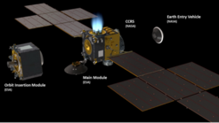
The NASA-ESA plan is to return samples using three missions: a sample collection mission (Perseverance), a sample retrieval mission (Sample Retrieval Lander + Mars ascent vehicle + Sample Transfer arm + 2 Ingenuity class helicopters), and a return mission (Earth Return Orbiter). The mission hopes to resolve the question of whether Mars once harbored life.

Sample collection

The Mars 2020 mission landed the Perseverance rover, which is storing samples to be returned to Earth later. After consideration, it was decided that given Perseverance's expected longevity, it will be the primary means of transporting samples to Sample Retrieval Lander (SRL).

Mars 2020 Perseverance Rover

Sample retrieval

Mars Sample Return Program
(Artwork; 27 July 2022)

The sample retrieval mission involves launching a sample return lander in 2028 with the Mars Ascent Vehicle and two Ingenuity class sample recovery helicopters, both of which will be collecting the samples with a tiny robotic arm as a backup for Perseverance. The rover and helicopters will transport the samples to the SRL lander. SRL's robotic arm will be used to extract the samples and load them into the Sample Return Capsule in the Ascent Vehicle. It is planned to land near the Octavia E. Butler Landing site in 2029.

Mars Ascent Vehicle (MAV)

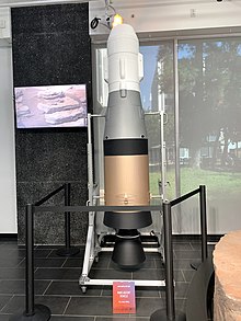
A mock-up of Mars Ascent Vehicle on display stand
 
VECTOR release sequence

MAV is a 3-meter long, two-stage, solid-fueled rocket that will deliver the collected samples from the surface of Mars to the Earth Return Orbiter. Early in 2022, Lockheed Martin was awarded a contract to partner with NASA's Marshall Space Flight Center in developing the MAV. It is planned to be catapulted into the air just before it ignites, at a rate of 16 feet (5 meters) per second, to remove the odds of wrong liftoff like slipping or tilting of SRL under rocket's shear weight and exhaust at liftoff. This Vertically Ejected Controlled Tip-off Release (VECTOR) system adds a slight rotation during launch, pitching the rocket up and away from the surface. MAV would enter a 380 km orbit. It will remain stowed inside a cylinder on the SRL and will have a thermal protective coating. The rocket's first stage would be run by a single updated STAR-20 engine burning for 70 seconds, while the second stage would have a single updated STAR-15 engine burning for another 27 seconds. They would be separated by a coast phase, after which the sample container would be released in orbit. As of early 2022, the second stage is planned to be spin-stabilized to save weight in lieu of active guidance, while the Mars samples will result in an unknown payload mass distribution.

MAV is scheduled to be launched in 2028 on board the SRL lander.

Sample return

Earth Return Orbiter (ERO)

ERO is an ESA-developed spacecraft. It includes the NASA-built Capture and Containment and Return System to rendezvous with the samples delivered by MAV in low Mars orbit (LMO).

ERO is scheduled to launch on an Ariane 64 rocket in 2027 and arrive at Mars in 2028, using ion propulsion and a separate propulsion element to gradually reach the proper orbit and then rendezvous with the orbiting sample. The MAV's 2nd stage will have a radio beacon that will give controllers the information they need to get the ESA Earth Return Orbiter close enough to the Orbiting Sample to see it through reflective light and capture it for return to earth. The orbiter will retrieve and seal the canisters in orbit and use a NASA-built robotic arm to place the sealed container into an Earth-entry capsule. It will raise its orbit, release the propulsion element, and return to Earth during the 2033 Mars-to-Earth transfer window.

Earth Entry Vehicle (EEV)

The Capture/Containment and Return System (CCRS) would stow the sample in the EEV. EEV would return to Earth and land passively, without a parachute. The desert sand at the Utah Test and Training Range and shock absorbing materials in the vehicle were planned to protect the samples from impact forces. EEV is scheduled to land on Earth in 2033.

Components of the Sample Return Landers
 
Interior design of MAV, First Extraterrestrial Staging Rocket
 
MAV exterior design
 
MAV flight plan
 
Mars Sample Return 2020-2033 Timeline
 
Artist's concept of Mars sample return orbiter
cross section of the Earth return orbiter
 
Earth Return Orbiter
 
capture and containment system

Additional plans

China

China has announced plans for a Mars sample-return mission to be called Tianwen-3. The mission would launch in late 2028, with a lander and ascent vehicle on a Long March 5 and an orbiter and return module launched separately on a Long March 3B. Samples would be returned to Earth in July 2031.

A previous plan would have used a large spacecraft that could carry out all mission phases, including sample collection, ascent, orbital rendezvous, and return flight. This would have required the super-heavy-lift Long March 9 launch vehicle. Another plan involved using Tianwen-1 to cache the samples for retrieval.

France

France has worked towards a sample return for many years. This included concepts of an extraterrestrial sample curation facility for returned samples, and numerous proposals. They worked on the development of a Mars sample-return orbiter, which would capture and return the samples as part of a joint mission with other countries.

Japan

On 9 June 2015, the Japanese Aerospace Exploration Agency (JAXA) unveiled a plan named Martian Moons Exploration (MMX) to retrieve samples from Phobos or Deimos. Phobos's orbit is closer to Mars and its surface may have captured particles blasted from Mars. The launch from Earth is planned for September 2024, with a return to Earth in 2029. Japan has also shown interest in participating in an international Mars sample-return mission.

Russia

A Russian Mars sample-return mission concept is Mars-Grunt. It adopted Fobos-Grunt design heritage. 2011 plans envisioned a two-stage architecture with an orbiter and a lander (but no roving capability), with samples gathered from around the lander by a robotic arm.

Back contamination

Whether life forms exist on Mars is unresolved. Thus, MSR could potentially transfer viable organisms to Earth, resulting in back contamination — the introduction of extraterrestrial organisms into Earth's biosphere. The scientific consensus is that the potential for large-scale effects, either through pathogenesis or ecological disruption, is small. Returned samples would be treated as potentially biohazardous until scientists decide the samples are safe. The goal is that the probability of release of a Mars particle is less than one in a million.

The proposed NASA Mars sample-return mission will not be approved by NASA until the National Environmental Policy Act (NEPA) process has been completed. Furthermore, under the terms of Article VII of the Outer Space Treaty and other legal frameworks, were a release of organisms to occur, the releasing nation(s) would be liable for any resultant damages.

The sample-return mission would be tasked with preventing contact between the Martian environment and the exterior of the sample containers.

In order to eliminate the risk of parachute failure, the current plan is to use the thermal protection system to cushion the capsule upon impact (at terminal velocity). The sample container would be designed to withstand the force of impact. To receive the returned samples, NASA proposed a custom Biosafety Level 4 containment facility, the Mars Sample-Return Receiving facility (MSRRF).

Other scientists and engineers, notably Robert Zubrin of the Mars Society, argued in the Journal of Cosmology that contamination risk is functionally zero leaving little need to worry. They cite, among other things, lack of any known incident although trillions of kilograms of material have been exchanged between Mars and Earth via meteorite impacts.

The International Committee Against Mars Sample Return (ICAMSR) is an advocacy group led by Barry DiGregorio, that campaigns against a Mars sample-return mission. While ICAMSR acknowledges a low probability for biohazards, it considers the proposed containment measures to be unsafe. ICAMSR advocates more in situ studies on Mars, and preliminary biohazard testing at the International Space Station before the samples are brought to Earth. DiGregorio accepts the conspiracy theory of a NASA coverup regarding the discovery of microbial life by the 1976 Viking landers. DiGregorio also supports a view that several pathogens – such as common viruses – originate in space and probably caused some mass extinctions and pandemics. These claims connecting terrestrial disease and extraterrestrial pathogens have been rejected by the scientific community.

Gravity anomaly

From Wikipedia, the free encyclopedia
https://en.wikipedia.org/wiki/Gravity_anomaly

The gravity anomaly at a location on the Earth's surface is the difference between the observed value of gravity and the value predicted by a theoretical model. If the Earth were an ideal oblate spheroid of uniform density, then the gravity measured at every point on its surface would be given precisely by a simple algebraic expression. However, the Earth has a rugged surface and non-uniform composition, which distorts its gravitational field. The theoretical value of gravity can be corrected for altitude and the effects of nearby terrain, but it usually still differs slightly from the measured value. This gravity anomaly can reveal the presence of subsurface structures of unusual density. For example, a mass of dense ore below the surface will give a positive anomaly due to the increased gravitational attraction of the ore.

Different theoretical models will predict different values of gravity, and so a gravity anomaly is always specified with reference to a particular model. The Bouguer, free-air, and isostatic gravity anomalies are each based on different theoretical corrections to the value of gravity.

A gravity survey is conducted by measuring the gravity anomaly at many locations in a region of interest, using a portable instrument called a gravimeter. Careful analysis of the gravity data allows geologists to make inferences about the subsurface geology.

Definition

The gravity anomaly is the difference between the observed acceleration of an object in free fall (gravity) near a planet's surface, and the corresponding value predicted by a model of the planet's gravitational field. Typically the model is based on simplifying assumptions, such as that, under its self-gravitation and rotational motion, the planet assumes the figure of an ellipsoid of revolution. Gravity on the surface of this reference ellipsoid is then given by a simple formula which only contains the latitude. For Earth, the reference ellipsoid is the International Reference Ellipsoid, and the value of gravity predicted for points on the ellipsoid is the normal gravity, gn.

Gravity anomalies were first discovered in 1672, when the French astronomer Jean Richter established an observatory on the island of Cayenne. Richter was equipped with a highly precise pendulum clock which had been carefully calibrated at Paris before his departure. However, he found that the clock ran too slowly in Cayenne, compared with the apparent motion of the stars. Fifteen years later, Isaac Newton used his newly formulated universal theory of gravitation to explain the anomaly. Newton showed that the measured value of gravity was affected by the rotation of the Earth, which caused the Earth's equator to bulge out slightly relative to its poles. Cayenne, being nearer the equator than Paris, would be both further from the center of Earth (reducing the Earth's bulk gravitational attraction slightly) and subject to stronger centrifugal acceleration from the Earth's rotation. Both these effects reduce the value of gravity, explaining why Richter's pendulum clock, which depended on the value of gravity, ran too slowly. Correcting for these effects removed most of this anomaly.

To understand the nature of the gravity anomaly due to the subsurface, a number of corrections must be made to the measured gravity value. Different theoretical models will include different corrections to the value of gravity, and so a gravity anomaly is always specified with reference to a particular model. The Bouguer, free-air, and isostatic gravity anomalies are each based on different theoretical corrections to the value of gravity.

The model field and corrections

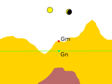
Hypothetical gravity measurement. The value of gravity is measured at the red point marked . The green point is the normal gravity , which lies on the reference ellipsoid.
 
Hypothetical gravity measurement corrected for tidal forces
 
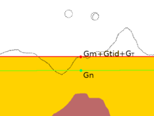
Hypothetical gravity measurement corrected for tides and terrain
 
Hypothetical gravity measurement with free-air corrections
Hypothetical gravity measurement with Bouguer correction

The starting point for the model field is the International Reference Ellipsoid, which gives the normal gravity gn for every point on the Earth's idealized shape. Further refinements of the model field are usually expressed as corrections added to the measured gravity or (equivalently) subtracted from the normal gravity. At a minimum, these include the tidal correction △gtid, the terrain correction △gT, and the free air correction △gFA. Other corrections are added for various gravitational models. The difference between the corrected measured gravity and the normal gravity is the gravity anomaly.

The normal gravity

The normal gravity accounts for the bulk gravitation of the entire Earth, corrected for its idealized shape and rotation. It is given by the formula:

where = 9.780327 m s−2; = 5.30244 × 10⁻³; and = -5.8 × 10⁻⁶. This is accurate to 0.1 mgal at any latitude . When greater precision is needed, a more elaborate formula gives the normal gravity with an accuracy of 0.0001 mgal.

The tidal correction

The Sun and Moon create time-dependent tidal forces that affect the measured value of gravity by about 0.3 mgal. Two-thirds of this is from the Moon. This effect is very well understood and can be calculated precisely for a given time and location using astrophysical data and formulas, to yield the tidal correction △gtid.

The terrain correction

The local topography of the land surface affects the gravity measurement. Both terrain higher than the measurement point and valleys lower than the measurement point reduce the measured value of gravity. This is taken into account by the terrain correction △gT. The terrain correction is calculated from knowledge of the local topography and estimates of the density of the rock making up the high ground. In effect, the terrain correction levels the terrain around the measurement point.

The terrain correction must be calculated for every point at which gravity is measured, taking into account every hill or valley whose difference in elevation from the measurement point is greater than about 5% of its distance from the measurement point. This is tedious and time-consuming but necessary for obtaining a meaningful gravity anomaly.

The free-air correction

The next correction is the free-air correction. This takes into account the fact that the measurement is usually at a different elevation than the reference ellipsoid at the measurement latitude and longitude. For a measurement point above the reference ellipsoid, this means that the gravitational attraction of the bulk mass of the earth is slightly reduced. The free-air correction is simply 0.3086 mgal m−1 times the elevation above the reference ellipsoid.

The remaining gravity anomaly at this point in the reduction is called the free-air anomaly. That is, the free-air anomaly is:

Bouguer plate correction

The free-air anomaly does not take into account the layer of material (after terrain leveling) outside the reference ellipsoid. The gravitational attraction of this layer or plate is taken into account by the Bouguer plate correction, which is -0.0419 × 10⁻³ ρ h mgal m2 kg−1. The density of crustal rock, ρ, is usually taken to be 2670 kg m3 so the Bouguer plate correction is usually taken as -0.3086 mgal m−1 h. Here h is the elevation above the reference ellipsoid.

The remaining gravity anomaly at this point in the reduction is called the Bouguer anomaly. That is, the Bouguer anomaly is:

Isostatic correction

The Bouguer anomaly is positive over ocean basins and negative over high continental areas. This shows that the low elevation of ocean basins and high elevation of continents is compensated by the thickness of the crust at depth. The higher terrain is held up by the buoyancy of thicker crust "floating" on the mantle.

The isostatic anomaly is defined as the Bouger anomaly minus the gravity anomaly due to the subsurface compensation, and is a measure of the local departure from isostatic equilibrium, due to dynamic processes in the viscous mantle. At the center of a level plateau, it is approximately equal to the free air anomaly. The isostatic correction is dependent on the isostatic model used to calculate isostatic balance, and so is slightly different for the Airy-Heiskanen model (which assumes that the crust and mantle are uniform in density and isostatic balance is provided by changes in crust thickness), the Pratt-Hayford model (which assumes that the bottom of the crust is at the same depth everywhere and isostatic balance is provided by lateral changes in crust density), and the Vening Meinesz elastic plate model (which assumes the crust acts like an elastic sheet).

Forward modelling is the process of computing the detailed shape of the compensation required by a theoretical model and using this to correct the Bouguer anomaly to yield an isostatic anomaly.

Causes

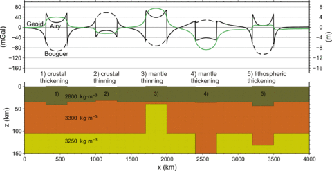
Gravity and geoid anomalies caused by various crustal and lithospheric thickness changes relative to a reference configuration. All settings are under local isostatic compensation with an elevation of either +1000 or -1000 m above the reference level.
 
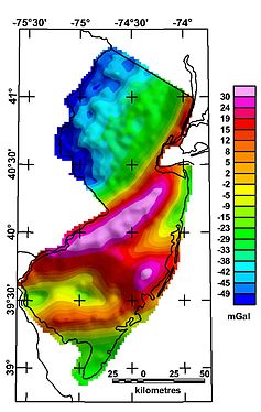
(Bouguer) gravity anomaly map of the state of New Jersey (USGS)

Lateral variations in gravity anomalies are related to anomalous density distributions within the Earth. Local measurements of the gravity of Earth help us to understand the planet's internal structure.

Regional causes

The Bouguer anomaly over continents is generally negative, especially over mountain ranges. For example, typical Bouguer anomalies in the Central Alps are −150 milligals. By contrast, the Bouguer anomaly is positive over oceans. These anomalies reflect the varying thickness of the Earth's crust. The higher continental terrain is supported by thick, low-density crust that "floats" on the denser mantle, while the ocean basins are floored by much thinner oceanic crust. The free-air and isostatic anomalies are small near the centers of ocean basins or continental plateaus, showing that these are approximately in isostatic equilibrium. The gravitational attraction of the high terrain is balanced by the reduced gravitational attraction of its underlying low-density roots. This brings the free-air anomaly, which omits the correction terms for either, close to zero. The isostatic anomaly includes correction terms for both effects, which reduces it nearly to zero as well. The Bouguer anomaly includes only the negative correction for the high terrain and so is strongly negative.

More generally, the Airy isostatic anomaly is zero over regions where there is complete isostatic compensation. The free-air anomaly is also close to zero except near boundaries of crustal blocks. The Bouger anomaly is very negative over elevated terrain. The opposite is true for the theoretical case of terrain that is completely uncompensated: The Bouger anomaly is zero while the free-air and Airy isostatic anomalies are very positive.

The Bouger anomaly map of the Alps shows additional features besides the expected deep mountain roots. A positive anomaly is associated with the Ivrea body, a wedge of dense mantle rock caught up by an ancient continental collision. The low-density sediments of the Molasse basin produce a negative anomaly. Larger surveys across the region provide evidence of a relict subduction zone. Negative isostatic anomalies in Switzerland correlate with areas of active uplift, while positive anomalies are associated with subsidence.

Over mid-ocean ridges, the free-air anomalies are small and correlate with the ocean bottom topography. The ridge and its flanks appear to be fully isostatically compensated. There is a large Bouger positive, of over 350 mgal, beyond 1,000 kilometers (620 mi) from the ridge axis, which drops to 200 over the axis. This is consistent with seismic data and suggests the presence of a low-density magma chamber under the ridge axis.

There are intense isostatic and free-air anomalies along island arcs. These are indications of strong dynamic effects in subduction zones. The free-air anomaly is around +70 mgal along the Andes coast, and this is attributed to the subducting dense slab. The trench itself is very negative, with values more negative than -250 mgal. This arises from the low-density ocean water and sediments filling the trench.

Gravity anomalies provide clues on other processes taking place deep in the lithosphere. For example, the formation and sinking of a lithospheric root may explain negative isostatic anomalies in eastern Tien Shan. The Hawaiian gravity anomaly appears to be fully compensated within the lithosphere, not within the underlying aesthenosphere, contradicting the explanation of the Hawaiian rise as a product of aesthenosphere flow associated with the underlying mantle plume. The rise may instead be a result of lithosphere thinning: The underlying aesthenosphere is less dense than the lithosphere and it rises to produce the swell. Subsequent cooling thickens the lithosphere again and subsidence takes place.

Local anomalies

Local anomalies are used in applied geophysics. For example, a local positive anomaly may indicate a body of metallic ores. Salt domes are typically expressed in gravity maps as lows, because salt has a low density compared to the rocks the dome intrudes.

At scales between entire mountain ranges and ore bodies, Bouguer anomalies may indicate rock types. For example, the northeast-southwest trending high across central New Jersey represents a graben of Triassic age largely filled with dense basalts.

Satellite measurements

Gravity anomaly map from GRACE

Currently, the static and time-variable Earth's gravity field parameters are being determined using modern satellite missions, such as GOCE, CHAMP, Swarm, GRACE and GRACE-FO. The lowest-degree parameters, including the Earth's oblateness and geocenter motion are best determined from Satellite laser ranging.

Large-scale gravity anomalies can be detected from space, as a by-product of satellite gravity missions, e.g., GOCE. These satellite missions aim at the recovery of a detailed gravity field model of the Earth, typically presented in the form of a spherical-harmonic expansion of the Earth's gravitational potential, but alternative presentations, such as maps of geoid undulations or gravity anomalies, are also produced.

The Gravity Recovery and Climate Experiment (GRACE) consists of two satellites that can detect gravitational changes across the Earth. Also these changes can be presented as gravity anomaly temporal variations. The Gravity Recovery and Interior Laboratory (GRAIL) also consisted of two spacecraft orbiting the Moon, which orbited for three years before their deorbit in 2015.

Isotope geochemistry

From Wikipedia, the free encyclopedia
Jump to navigation Jump to search

Isotope geochemistry is an aspect of geology based upon the study of natural variations in the relative abundances of isotopes of various elements. Variations in isotopic abundance are measured by isotope ratio mass spectrometry, and can reveal information about the ages and origins of rock, air or water bodies, or processes of mixing between them.

Stable isotope geochemistry is largely concerned with isotopic variations arising from mass-dependent isotope fractionation, whereas radiogenic isotope geochemistry is concerned with the products of natural radioactivity.

Stable isotope geochemistry

For most stable isotopes, the magnitude of fractionation from kinetic and equilibrium fractionation is very small; for this reason, enrichments are typically reported in "per mil" (‰, parts per thousand). These enrichments (δ) represent the ratio of heavy isotope to light isotope in the sample over the ratio of a standard. That is,

Hydrogen

Carbon

Carbon has two stable isotopes, 12C and 13C, and one radioactive isotope, 14C.

The stable carbon isotope ratio, δ13C, is measured against Vienna Pee Dee Belemnite (VPDB). The stable carbon isotopes are fractionated primarily by photosynthesis (Faure, 2004). The 13C/12C ratio is also an indicator of paleoclimate: a change in the ratio in the remains of plants indicates a change in the amount of photosynthetic activity, and thus in how favorable the environment was for the plants. During photosynthesis, organisms using the C3 pathway show different enrichments compared to those using the C4 pathway, allowing scientists not only to distinguish organic matter from abiotic carbon, but also what type of photosynthetic pathway the organic matter was using. Occasional spikes in the global 13C/12C ratio have also been useful as stratigraphic markers for chemostratigraphy, especially during the Paleozoic.

The 14C ratio has been used to track ocean circulation, among other things.

Nitrogen

Nitrogen has two stable isotopes, 14N and 15N. The ratio between these is measured relative to nitrogen in ambient air. Nitrogen ratios are frequently linked to agricultural activities. Nitrogen isotope data has also been used to measure the amount of exchange of air between the stratosphere and troposphere using data from the greenhouse gas N2O.

Oxygen

Oxygen has three stable isotopes, 16O, 17O, and 18O. Oxygen ratios are measured relative to Vienna Standard Mean Ocean Water (VSMOW) or Vienna Pee Dee Belemnite (VPDB). Variations in oxygen isotope ratios are used to track both water movement, paleoclimate, and atmospheric gases such as ozone and carbon dioxide. Typically, the VPDB oxygen reference is used for paleoclimate, while VSMOW is used for most other applications. Oxygen isotopes appear in anomalous ratios in atmospheric ozone, resulting from mass-independent fractionation. Isotope ratios in fossilized foraminifera have been used to deduce the temperature of ancient seas.

Sulfur

Sulfur has four stable isotopes, with the following abundances: 32S (0.9502), 33S (0.0075), 34S (0.0421) and 36S (0.0002). These abundances are compared to those found in Cañon Diablo troilite. Variations in sulfur isotope ratios are used to study the origin of sulfur in an orebody and the temperature of formation of sulfur–bearing minerals as well as a biosignature that can reveal presence of sulfate reducing microbes.

Radiogenic isotope geochemistry

Radiogenic isotopes provide powerful tracers for studying the ages and origins of Earth systems. They are particularly useful to understand mixing processes between different components, because (heavy) radiogenic isotope ratios are not usually fractionated by chemical processes.

Radiogenic isotope tracers are most powerful when used together with other tracers: The more tracers used, the more control on mixing processes. An example of this application is to the evolution of the Earth's crust and Earth's mantle through geological time.

Lead–lead isotope geochemistry

Lead has four stable isotopes: 204Pb, 206Pb, 207Pb, and 208Pb.

Lead is created in the Earth via decay of actinide elements, primarily uranium and thorium.

Lead isotope geochemistry is useful for providing isotopic dates on a variety of materials. Because the lead isotopes are created by decay of different transuranic elements, the ratios of the four lead isotopes to one another can be very useful in tracking the source of melts in igneous rocks, the source of sediments and even the origin of people via isotopic fingerprinting of their teeth, skin and bones.

It has been used to date ice cores from the Arctic shelf, and provides information on the source of atmospheric lead pollution.

Lead–lead isotopes has been successfully used in forensic science to fingerprint bullets, because each batch of ammunition has its own peculiar 204Pb/206Pb vs 207Pb/208Pb ratio.

Samarium–neodymium

Samariumneodymium is an isotope system which can be utilised to provide a date as well as isotopic fingerprints of geological materials, and various other materials including archaeological finds (pots, ceramics).

147Sm decays to produce 143Nd with a half life of 1.06x10¹¹ years.

Dating is achieved usually by trying to produce an isochron of several minerals within a rock specimen. The initial 143Nd/144Nd ratio is determined.

This initial ratio is modelled relative to CHUR - the Chondritic Uniform Reservoir - which is an approximation of the chondritic material which formed the solar system. CHUR was determined by analysing chondrite and achondrite meteorites.

The difference in the ratio of the sample relative to CHUR can give information on a model age of extraction from the mantle (for which an assumed evolution has been calculated relative to CHUR) and to whether this was extracted from a granitic source (depleted in radiogenic Nd), the mantle, or an enriched source.

Rhenium–osmium

Rhenium and osmium are siderophile elements which are present at very low abundances in the crust. Rhenium undergoes radioactive decay to produce osmium. The ratio of non-radiogenic osmium to radiogenic osmium throughout time varies.

Rhenium prefers to enter sulfides more readily than osmium. Hence, during melting of the mantle, rhenium is stripped out, and prevents the osmium–osmium ratio from changing appreciably. This locks in an initial osmium ratio of the sample at the time of the melting event. Osmium–osmium initial ratios are used to determine the source characteristic and age of mantle melting events.

Noble gas isotopes

Natural isotopic variations amongst the noble gases result from both radiogenic and nucleogenic production processes. Because of their unique properties, it is useful to distinguish them from the conventional radiogenic isotope systems described above.

Helium-3

Helium-3 was trapped in the planet when it formed. Some 3He is being added by meteoric dust, primarily collecting on the bottom of oceans (although due to subduction, all oceanic tectonic plates are younger than continental plates). However, 3He will be degassed from oceanic sediment during subduction, so cosmogenic 3He is not affecting the concentration or noble gas ratios of the mantle.

Helium-3 is created by cosmic ray bombardment, and by lithium spallation reactions which generally occur in the crust. Lithium spallation is the process by which a high-energy neutron bombards a lithium atom, creating a 3He and a 4He ion. This requires significant lithium to adversely affect the 3He/4He ratio.

All degassed helium is lost to space eventually, due to the average speed of helium exceeding the escape velocity for the Earth. Thus, it is assumed the helium content and ratios of Earth's atmosphere have remained essentially stable.

It has been observed that 3He is present in volcano emissions and oceanic ridge samples. How 3He is stored in the planet is under investigation, but it is associated with the mantle and is used as a marker of material of deep origin.

Due to similarities in helium and carbon in magma chemistry, outgassing of helium requires the loss of volatile components (water, carbon dioxide) from the mantle, which happens at depths of less than 60 km. However, 3He is transported to the surface primarily trapped in the crystal lattice of minerals within fluid inclusions.

Helium-4 is created by radiogenic production (by decay of uranium/thorium-series elements). The continental crust has become enriched with those elements relative to the mantle and thus more He4 is produced in the crust than in the mantle.

The ratio (R) of 3He to 4He is often used to represent 3He content. R usually is given as a multiple of the present atmospheric ratio (Ra).

Common values for R/Ra:

  • Old continental crust: less than 1
  • mid-ocean ridge basalt (MORB): 7 to 9
  • Spreading ridge rocks: 9.1 plus or minus 3.6
  • Hotspot rocks: 5 to 42
  • Ocean and terrestrial water: 1
  • Sedimentary formation water: less than 1
  • Thermal spring water: 3 to 11

3He/4He isotope chemistry is being used to date groundwaters, estimate groundwater flow rates, track water pollution, and provide insights into hydrothermal processes, igneous geology and ore genesis.

Isotopes in actinide decay chains

Isotopes in the decay chains of actinides are unique amongst radiogenic isotopes because they are both radiogenic and radioactive. Because their abundances are normally quoted as activity ratios rather than atomic ratios, they are best considered separately from the other radiogenic isotope systems.

Protactinium/Thorium – 231Pa / 230Th

Uranium is well mixed in the ocean, and its decay produces 231Pa and 230Th at a constant activity ratio (0.093). The decay products are rapidly removed by adsorption on settling particles, but not at equal rates. 231Pa has a residence equivalent to the residence time of deep water in the Atlantic basin (around 1000 yrs) but 230Th is removed more rapidly (centuries). Thermohaline circulation effectively exports 231Pa from the Atlantic into the Southern Ocean, while most of the 230Th remains in Atlantic sediments. As a result, there is a relationship between 231Pa/230Th in Atlantic sediments and the rate of overturning: faster overturning produces lower sediment 231Pa/230Th ratio, while slower overturning increases this ratio. The combination of δ13C and 231Pa/230Th can therefore provide a more complete insight into past circulation changes.

Anthropogenic isotopes

Tritium/helium-3

Tritium was released to the atmosphere during atmospheric testing of nuclear bombs. Radioactive decay of tritium produces the noble gas helium-3. Comparing the ratio of tritium to helium-3 (3H/3He) allows estimation of the age of recent ground waters. A small amount of Tritium is also produced naturally by cosmic ray spallation and spontaneous ternary fission in natural uranium and thorium, but due to the relatively short half-life of Tritium and the relatively small quantities (compared to those from humandmade sources) those sources of Tritium usually play only a secondary role in the analysis of groundwater.

Bayesian inference

From Wikipedia, the free encyclopedia https://en.wikipedia.org/wiki/Bayesian_inference Bayesian inference ( / ...