Search This Blog

Saturday, December 30, 2023

Large low-shear-velocity provinces

Animation showing LLSVPs as inferred using seismic tomography

Large low-shear-velocity provinces, LLSVPs, also called LLVPs or superplumes, are characteristic structures of parts of the lowermost mantle (the region surrounding the outer core) of Earth. These provinces are characterized by slow shear wave velocities and were discovered by seismic tomography of deep Earth. There are two main provinces: the African LLSVP and the Pacific LLSVP. Both extend laterally for thousands of kilometers and possibly up to 1,000 kilometres vertically from the core–mantle boundary. The Pacific LLSVP is 3,000 kilometers (1,900 miles) across, and underlies four hotspots that suggest multiple mantle plumes underneath. These zones represent around 8% of the volume of the mantle (6% of Earth). Other names for LLSVPs include "superswells", "thermo-chemical piles", or "hidden reservoirs". Most of these names, however, are more interpretive of their proposed geodynamical or geochemical effects. For example, the name "thermo-chemical pile" interprets LLSVPs as lower-mantle piles of thermally hot and/or chemically distinct material. LLSVPs are still relatively mysterious, and many questions remain about their nature, origin, and geodynamic effects.

Recent studies suggest superplumes may represent buried relics of the sunken remnants of Theia, an ancient planet that is thought to have collided with Earth and lead the Moon to form.

Seismological constraints

LLSVPs were discovered in full mantle seismic tomographic models of shear velocity as slow features in the lowermost mantle beneath Africa and the Pacific. The boundaries of these features appear fairly consistent across models when applying objective k-means clustering. The global spherical harmonic degree two structure is strong and aligns with its smallest moments of inertia along with the two LLSVPs. This means, by using shear wave velocities, the established locations of the LLSVPs are not only verified, a stable pattern for mantle convection emerges. This stable configuration is responsible for the geometry of plate motions at the surface due as well as mantle convection. Another name for the degree two structure, a roughly 200 kilometers (120 miles) thick layer of the lower mantle directly above the core–mantle boundary, is the D″ ("D double-prime" or "D prime prime"). The LLSVPs lie around the equator, but mostly on the Southern Hemisphere. Global tomography models inherently result in smooth features; local waveform modeling of body waves, however, has shown that the LLSVPs have sharp boundaries. The sharpness of the boundaries makes it difficult to explain the features by temperature alone; the LLSVPs need to be compositionally distinct to explain the velocity jump. Ultra low velocity zones at smaller scales have been discovered mainly at the edges of these LLSVPs.

By using the solid Earth tide, the density of these regions has been determined. The bottom two thirds are 0.5% denser than the bulk of the mantle. However, tidal tomography cannot say exactly how the excess mass is distributed. The overdensity may be due to primordial material or subducted ocean slabs.

The African large low-shear velocity province may be a potential cause for the South Atlantic Anomaly.

Possible origin

Several hypotheses have been proposed for the origin and persistence of LLSVPs, depending on whether the provinces represent purely thermal unconformities (i.e. are isochemical in nature, of the same chemical composition as the surrounding mantle) or represent chemical unconformities as well (i.e. are thermochemical in nature, of different chemical composition from the surrounding mantle).

If LLSVPs represent purely thermal unconformities, then they may have formed as megaplumes of hot, upwelling mantle. However, geodynamical studies predict that isochemical upwelling of a hotter, lower viscosity material should produce long, narrow plumes, unlike the large, wide plumes seen in LLSVPs.

The current leading hypothesis for the LLSVPs is the accumulation of subducted oceanic slabs. This corresponds with the locations of known slab graveyards surrounding the Pacific LLSVP. These graveyards are thought to be the reason for the high velocity zone anomalies surrounding the Pacific LLSVP and are thought to have formed by subduction zones that were around long before the dispersion—some 750 million years ago—of the supercontinent Rodinia. Aided by the phase transformation, the temperature would partially melt the slabs, to form a dense heavy melt that pools and forms the ultra low velocity zone structures at the bottom of the core-mantle boundary closer to the LLSVP than the slab graveyards. The rest of the material is then carried upwards due to chemical-induced buoyancy and contributes to the high levels of basalt found at the mid-ocean ridge. The resulting motion forms small clusters of small plumes right above the core-mantle boundary that combine to form larger plumes and then contribute to superplumes. The Pacific and African LLSVP, in this scenario, are originally created by a discharge of heat from the core (4000 K) to the much colder mantle (2000 K), the recycled lithosphere is only fuel that helps drive the superplume convection. Since it would be difficult for the Earth's core to maintain this high heat by itself, it gives support for the existence of radiogenic nuclides in the core, as well as the indication that if fertile subducted lithosphere stops subducting in locations preferable for superplume consumption, it will mark the demise of that superplume.

A second proposed origin for the LLSVPs is that their formation is related to the giant-impact hypothesis, which states that the Moon formed after the Earth collided with a planet-sized body called Theia. The hypothesis suggests that the LLSVPs may represent fragments of Theia's mantle which sank through to Earth's core-mantle boundary. The higher density of the mantle fragments is due to their enrichment in iron(II) oxide with respect to the rest of Earth's mantle. This higher iron(II) oxide composition would also be consistent with the isotope geochemistry of lunar samples, as well as that of the oceanic island basalts overlying the LLSVPs.

Dynamics

Geodynamic mantle convection models have included compositional distinctive material. The material tends to get swept up in ridges or piles. When including realistic past plate motions into the modeling, the material gets swept up in locations that are remarkably similar to the present day location of the LLSVPs. These locations also correspond with known slab graveyard locations mentioned in the origin section. These types of models, as well as the observation that the degree two structure of the LLSVPs is orthogonal to the path of true polar wander, suggest these mantle structures have been stable over large amounts of time. This geometrical relationship is also consistent with the position of the supercontinent Pangaea, and the formation of the current geoid pattern due to continental break-up from the superswell below. However, the heat from the core is not enough to sustain the energy needed to fuel the superplume(s) located at the LLSVPs. There is a phase transition from perovskite to post-perovskite from the down welling slab(s) that causes an exothermic reaction. This exothermic reaction helps to heat the LLSVP, but it is not sufficient to account for the total energy needed to sustain it. So it is hypothesized that the material from the slab graveyard can become extremely dense and form large pools of melt concentrate enriched in uranium, thorium, and potassium. These concentrated radiogenic elements are thought to provide the high temperatures needed. So, the appearance and disappearance of slab graveyards predicts the birth and death of an LLSVP, potentially changing the dynamics of all plate tectonics.

Archean

From Wikipedia, the free encyclopedia
Archean
4031 ± 3 – 2500 Ma
Artist's impression of an Archean landscape.
Chronology
Etymology
Name formalityFormal
Alternate spelling(s)Archaean, Archæan
Synonym(s)Eozoic
J.W. Dawson, 1865
Usage information
Celestial bodyEarth
Regional usageGlobal (ICS)
Time scale(s) usedICS Time Scale
Definition
Chronological unitEon
Stratigraphic unitEonothem
Time span formalityFormal
Lower boundary definitionTen oldest U-Pb zircon ages
Lower boundary GSSAAlong the Acasta River, Northwest Territories, Canada
65.1738°N 115.5538°W
Lower GSSA ratified2023
Upper boundary definitionDefined Chronometrically
Upper GSSA ratified1991

The Archean Eon (IPA: /ɑːrˈkən/ ar-KEE-ən, also spelled Archaean or Archæan), in older sources sometimes called the Archaeozoic, is the second of the four geologic eons of Earth's history, preceded by the Hadean Eon and followed by the Proterozoic. The Archean represents the time period from 4,031 to 2,500 Ma (millions of years ago). The Late Heavy Bombardment is hypothesized to overlap with the beginning of the Archean. The Huronian glaciation occurred at the end of the eon.

The Earth during the Archean was mostly a water world: there was continental crust, but much of it was under an ocean deeper than today's oceans. Except for some trace minerals, today's oldest continental crust dates back to the Archean. Much of the geological detail of the Archean has been destroyed by subsequent activity. The Earth's atmosphere was also vastly different in composition from today's: the prebiotic atmosphere was a reducing atmosphere rich in methane and lacking free oxygen.

The earliest known life, mostly represented by shallow-water microbial mats called stromatolites, started in the Archean and remained simple prokaryotes (archaea and eubacteria) throughout the eon. The earliest photosynthetic processes, especially those by early cyanobacteria, appeared in the mid/late Archean and led to a permanent chemical change in the ocean and the atmosphere after the Archean.

Etymology and changes in classification

The word Archean is derived from the Greek word arkhē (αρχή), meaning 'beginning, origin'. The Pre-Cambrian eon had been believed to be without life (azoic); however, fossils were found in deposits that were judged to belong to the Azoic age. Before the Hadean Eon was recognized, the Archean spanned Earth's early history from its formation about 4,540 million years ago until 2,500 million years ago.

Instead of being based on stratigraphy, the beginning and end of the Archean Eon are defined chronometrically. The eon's lower boundary or starting point of 4,031±3 million years ago is officially recognized by the International Commission on Stratigraphy.

Geology

When the Archean began, the Earth's heat flow was nearly three times as high as it is today, and it was still twice the current level at the transition from the Archean to the Proterozoic (2,500 Ma). The extra heat was partly remnant heat from planetary accretion, from the formation of the metallic core, and partly arose from the decay of radioactive elements. As a result, the Earth's mantle was significantly hotter than today.

The evolution of Earth's radiogenic heat flow over time

Although a few mineral grains are known to be Hadean, the oldest rock formations exposed on the surface of the Earth are Archean. Archean rocks are found in Greenland, Siberia, the Canadian Shield, Montana, Wyoming (exposed parts of the Wyoming Craton), Minnesota (Minnesota River Valley), the Baltic Shield, the Rhodope Massif, Scotland, India, Brazil, western Australia, and southern Africa.[citation needed] Granitic rocks predominate throughout the crystalline remnants of the surviving Archean crust. These include great melt sheets and voluminous plutonic masses of granite, diorite, layered intrusions, anorthosites and monzonites known as sanukitoids. Archean rocks are often heavily metamorphized deep-water sediments, such as graywackes, mudstones, volcanic sediments, and banded iron formations. Volcanic activity was considerably higher than today, with numerous lava eruptions, including unusual types such as komatiite. Carbonate rocks are rare, indicating that the oceans were more acidic, due to dissolved carbon dioxide, than during the Proterozoic. Greenstone belts are typical Archean formations, consisting of alternating units of metamorphosed mafic igneous and sedimentary rocks, including Archean felsic volcanic rocks. The metamorphosed igneous rocks were derived from volcanic island arcs, while the metamorphosed sediments represent deep-sea sediments eroded from the neighboring island arcs and deposited in a forearc basin. Greenstone belts, which include both types of metamorphosed rock, represent sutures between the protocontinents.

Plate tectonics likely started vigorously in the Hadean, but slowed down in the Archean. The slowing of plate tectonics was probably due to an increase in the viscosity of the mantle due to outgassing of its water. Plate tectonics likely produced large amounts of continental crust, but the deep oceans of the Archean probably covered the continents entirely. Only at the end of the Archean did the continents likely emerge from the ocean. The emergence of continents towards the end of the Archaean initiated continental weathering that left its mark on the oxygen isotope record by enriching seawater with isotopically light oxygen.

Due to recycling and metamorphosis of the Archean crust, there is a lack of extensive geological evidence for specific continents. One hypothesis is that rocks that are now in India, western Australia, and southern Africa formed a continent called Ur as of 3,100 Ma. Another hypothesis, which conflicts with the first, is that rocks from western Australia and southern Africa were assembled in a continent called Vaalbara as far back as 3,600 Ma. Archean rock makes up only about 8% of Earth's present-day continental crust; the rest of the Archean continents have been recycled.

By the Neoarchean, plate tectonic activity may have been similar to that of the modern Earth, although there was a significantly greater occurrence of slab detachment resulting from a hotter mantle, rheologically weaker plates, and increased tensile stresses on subducting plates due to their crustal material metamorphosing from basalt into eclogite as they sank. There are well-preserved sedimentary basins, and evidence of volcanic arcs, intracontinental rifts, continent-continent collisions and widespread globe-spanning orogenic events suggesting the assembly and destruction of one and perhaps several supercontinents. Evidence from banded iron formations, chert beds, chemical sediments and pillow basalts demonstrates that liquid water was prevalent and deep oceanic basins already existed.

Asteroid impacts were frequent in the early Archean. Evidence from spherule layers suggests that impacts continued into the later Archean, at an average rate of about one impactor with a diameter greater than 10 kilometers (6 mi) every 15 million years. This is about the size of the Chicxulub impactor. These impacts would have been an important oxygen sink and would have caused drastic fluctuations of atmospheric oxygen levels.

Environment

The pale orange dot, an artist's impression of the early Earth which is believed to have appeared orange through its hazy, methane rich, prebiotic second atmosphere. Earth's atmosphere at this stage was somewhat comparable to today's atmosphere of Titan.

The Archean atmosphere is thought to have almost completely lacked free oxygen; oxygen levels were less than 0.001% of their present atmospheric level, with some analyses suggesting they were as low as 0.00001% of modern levels. However, transient episodes of heightened oxygen concentrations are known from this eon around 2,980–2,960 Ma, 2,700 Ma, and 2,501 Ma. The pulses of increased oxygenation at 2,700 and 2,501 Ma have both been considered by some as potential start points of the Great Oxygenation Event, which most scholars consider to have begun in the Palaeoproterozoic. Furthermore, oases of relatively high oxygen levels existed in some nearshore shallow marine settings by the Mesoarchean. The ocean was broadly reducing and lacked any persistent redoxcline, a water layer between oxygenated and anoxic layers with a strong redox gradient, which would become a feature in later, more oxic oceans. Despite the lack of free oxygen, the rate of organic carbon burial appears to have been roughly the same as in the present. Due to extremely low oxygen levels, sulphate was rare in the Archean ocean, and sulphides were produced primarily through reduction of organically sourced sulphite or through mineralisation of compounds containing reduced sulphur. The Archean ocean was enriched in heavier oxygen isotopes relative to the modern ocean, though δ18O values decreased to levels comparable to those of modern oceans over the course of the later part of the eon as a result of increased continental weathering.

Astronomers think that the Sun had about 75–80 percent of its present luminosity, yet temperatures on Earth appear to have been near modern levels only 500 million years after Earth's formation (the faint young Sun paradox). The presence of liquid water is evidenced by certain highly deformed gneisses produced by metamorphism of sedimentary protoliths. The moderate temperatures may reflect the presence of greater amounts of greenhouse gases than later in the Earth's history. Extensive abiotic denitrification took place on the Archean Earth, pumping the greenhouse gas nitrous oxide into the atmosphere. Alternatively, Earth's albedo may have been lower at the time, due to less land area and cloud cover.

Early life

The processes that gave rise to life on Earth are not completely understood, but there is substantial evidence that life came into existence either near the end of the Hadean Eon or early in the Archean Eon.

The earliest evidence for life on Earth is graphite of biogenic origin found in 3.7 billion–year-old metasedimentary rocks discovered in Western Greenland.

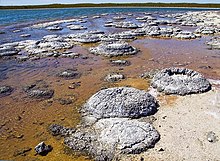
Lithified stromatolites on the shores of Lake Thetis, Western Australia. Archean stromatolites are the first direct fossil traces of life on Earth.

The earliest identifiable fossils consist of stromatolites, which are microbial mats formed in shallow water by cyanobacteria. The earliest stromatolites are found in 3.48 billion-year-old sandstone discovered in Western Australia. Stromatolites are found throughout the Archean and become common late in the Archean. Cyanobacteria were instrumental in creating free oxygen in the atmosphere.

Further evidence for early life is found in 3.47 billion-year-old baryte, in the Warrawoona Group of Western Australia. This mineral shows sulfur fractionation of as much as 21.1%, which is evidence of sulfate-reducing bacteria that metabolize sulfur-32 more readily than sulfur-34.

Evidence of life in the Late Hadean is more controversial. In 2015, biogenic carbon was detected in zircons dated to 4.1 billion years ago, but this evidence is preliminary and needs validation.

Earth was very hostile to life before 4,300 to 4,200 Ma, and the conclusion is that before the Archean Eon, life as we know it would have been challenged by these environmental conditions. While life could have arisen before the Archean, the conditions necessary to sustain life could not have occurred until the Archean Eon.

Life in the Archean was limited to simple single-celled organisms (lacking nuclei), called prokaryotes. In addition to the domain Bacteria, microfossils of the domain Archaea have also been identified. There are no known eukaryotic fossils from the earliest Archean, though they might have evolved during the Archean without leaving any. Fossil steranes, indicative of eukaryotes, have been reported from Archean strata but were shown to derive from contamination with younger organic matter. No fossil evidence has been discovered for ultramicroscopic intracellular replicators such as viruses.

Fossilized microbes from terrestrial microbial mats show that life was already established on land 3.22 billion years ago.

Hadean

From Wikipedia, the free encyclopedia
 
Hadean
4567.3 ± 0.16 – 4031 ± 3 Ma
Chronology
Etymology
Synonym(s)Priscoan Period
Harland et al., 1989
Usage information
Celestial bodyEarth
Regional usageGlobal (ICS)
Definition
Chronological unitEon
Stratigraphic unitEonothem
First proposed byPreston Cloud, 1972
Time span formalityFormal
Lower boundary definition(4567.30 ± 0.16) Ma
Lower GSSA ratifiedOctober 5th, 2022
Upper boundary definitionTen oldest U-Pb zircon ages
Upper boundary GSSAAlong the Acasta River, Northwest Territories, Canada
65.1738°N 115.5538°W
Upper GSSA ratified2023

The Hadean (IPA: /hˈdən, ˈhdiən/ hay-DEE-ən, HAY-dee-ən) is the first and oldest of the four known geologic eons of Earth's history, starting with the planet's formation about 4.54 Bya, now defined as (4567.30 ± 0.16) Mya set by the age of the oldest solid material in the Solar System found in some meteorites about 4.567 billion years old. The supposed interplanetary collision that created the Moon occurred early in this eon. The Hadean ended 4.031 billion years ago and was succeeded by the Archean eon, with the Late Heavy Bombardment hypothesized to have occurred at the Hadean-Archean boundary.

Hadean rocks are very rare, largely consisting of granular zircons from one locality (Jack Hills) in Western Australia. Hadean geophysical models remain controversial among geologists: it appears that plate tectonics and the growth of continents may have started in the Hadean. Earth in the early Hadean had a very thick carbon dioxide- and methane-rich prebiotic atmosphere, but eventually oceans made of liquid water were formed.

Etymology

The eon's name "Hadean" comes from Hades, the Greek god of the underworld (and can be used to describe the underworld itself), referring to the hellish conditions then prevailing on Early Earth: the planet had just been formed from recent accretion, and its surface was still molten with superheated lava, the abundance of short-lived radioactive elements, and frequent impact events with other Solar System bodies.

The term was coined by American geologist Preston Cloud, originally to label the period before the earliest-known rocks on Earth. W. Brian Harland later coined an almost synonymous term, the Priscoan Period, from priscus, the Latin word for 'ancient'. Other, older texts refer to the eon as the Pre-Archean.

Rock dating

Backscatter electron micrograph of detrital zircons from the Hadean (4.404 ± 0.008 Ga) metasediments of the Jack Hills, Narryer Gneiss Terrane, Western Australia

In the last decades of the 20th century, geologists identified a few Hadean rocks from western Greenland, northwestern Canada, and Western Australia. In 2015, traces of carbon minerals interpreted as "remains of biotic life" were found in 4.1-billion-year-old rocks in Western Australia.

The oldest dated zircon crystals, enclosed in a metamorphosed sandstone conglomerate in the Jack Hills of the Narryer Gneiss Terrane of Western Australia, date to 4.404 ± 0.008 Ga. This zircon is a slight outlier, with the oldest consistently-dated zircon falling closer to 4.35 Ga—around 200 million years after the hypothesized time of Earth's formation.

In many other areas, xenocryst (or relict) Hadean zircons enclosed in older rocks indicate that younger rocks have formed on older terranes and have incorporated some of the older material. One example occurs in the Guiana shield from the Iwokrama Formation of southern Guyana where zircon cores have been dated at 4.22 Ga.

Atmosphere

A sizable quantity of water would have been in the material that formed Earth. Water molecules would have escaped Earth's gravity more easily when the planet was less massive during its formation. Photodissociation by short-wave ultraviolet in sunlight could split surface water molecules into oxygen and hydrogen, the former of which would be readily removed by the then-reducing atmosphere, while the latter (along with the similarly light helium) would be expected to continually leave the atmosphere (even to the present day) due to atmospheric escape.

Part of the ancient planet is theorized to have been disrupted by the impact that created the Moon, which should have caused the melting of one or two large regions of Earth. Earth's present composition suggests that there was not complete remelting as it is difficult to completely melt and mix huge rock masses. However, a fair fraction of material should have been vaporized by this impact. The material would have condensed within 2,000 years. The initial magma ocean solidified within 5 million years, leaving behind hot volatiles which probably resulted in a heavy CO
2
atmosphere with hydrogen and water vapor. The initial heavy atmosphere had a surface temperature of 230 °C (446 °F) and an atmospheric pressure of above 27 standard atmospheres.

Oceans

Studies of zircons have found that liquid water may have existed between 4.0 and 4.4 billion years ago, very soon after the formation of Earth. Liquid water oceans existed despite the high surface temperature, because at an atmospheric pressure of 27 atmospheres, water remains liquid even at those high temperatures.

Asteroid impacts during the Hadean and into the Archean would have periodically disrupted the ocean. The geological record from 3.2 Gya contains evidence of multiple impacts of objects up to 100 kilometres (62 mi) in diameter. Each such impact would have boiled off up to 100 metres (330 ft) of a global ocean, and temporarily raised the atmospheric temperature to 500 °C (932 °F). However, the frequency of meteorite impacts is still under study: the Earth may have gone through long periods when liquid oceans and life were possible.

The liquid water would absorb the carbon dioxide in the early atmosphere, not enough by itself to substantially reduce the amount of CO
2
.

Plate tectonics

Evolution of continental crust and ocean depths (from Korenaga, 2021)

A 2008 study of zircons found that Australian Hadean rock contains minerals pointing to the existence of plate tectonics as early as 4 billion years ago (approximately 600 million years after Earth's formation). However, some geologists suggest that the zircons could have been formed by meteorite impacts. The direct evidence of Hadean geology from zircons is limited, because the zircons are largely gathered in one locality in Australia. Geophysical models are underconstrained, but can paint a general picture of the state of Earth in the Hadean.

Mantle convection in the Hadean was likely vigorous, due to lower viscosity. The lower viscosity was due to the high levels of radiogenic heat and the fact that water in the mantle had not yet fully outgassed. Whether the vigorous convection led to plate tectonics in the Hadean or was confined under a rigid lid is still a matter of debate. The presence of Hadean oceans are thought to trigger plate tectonics.

Subduction due to plate tectonics would have removed carbonate from the early oceans, contributing to the removal of the CO
2
-rich early atmosphere. Removal of this early atmosphere is evidence of Hadean plate tectonics.

If plate tectonics occurred in the Hadean, it would have formed continental crust. Different models predict different amounts of continental crust during the Hadean. The work of Dhiume et al. predicts that by the end of the Hadean, the continental crust had only 25% of today's area. The models of Korenaga, et al. predict that the continental crust grew to present-day volume sometime between 4.2 and 4.0 Gya.

Continents

The amount of exposed land in the Hadean is only loosely dependent on the amount of continental crust: it also depends on the ocean level. In models where plate tectonics started in the Archean, Earth has a global ocean in the Hadean. The high heat of the mantle may have made it difficult to support high elevations in the Hadean. If continents did form in the Hadean, their growth competed with outgassing of water from the mantle. Continents may have appeared in the mid-Hadean, and then disappeared under a thick ocean by the end of the Hadean. The limited amount of land has implications for the origin of life.

Operator (computer programming)

From Wikipedia, the free encyclopedia https://en.wikipedia.org/wiki/Operator_(computer_programmin...