Search This Blog

Wednesday, September 19, 2018

Geomorphology

From Wikipedia, the free encyclopedia

Badlands incised into shale at the foot of the North Caineville Plateau, Utah, within the pass carved by the Fremont River and known as the Blue Gate. GK Gilbert studied the landscapes of this area in great detail, forming the observational foundation for many of his studies on geomorphology.
Surface of the Earth, showing higher elevations in red.

Geomorphology (from Ancient Greek: γῆ, , "earth"; μορφή, morphḗ, "form"; and λόγος, lógos, "study") is the scientific study of the origin and evolution of topographic and bathymetric features created by physical, chemical or biological processes operating at or near the Earth's surface. Geomorphologists seek to understand why landscapes look the way they do, to understand landform history and dynamics and to predict changes through a combination of field observations, physical experiments and numerical modeling. Geomorphologists work within disciplines such as physical geography, geology, geodesy, engineering geology, archaeology, climatology and geotechnical engineering. This broad base of interests contributes to many research styles and interests within the field.

Overview

Waves and water chemistry lead to structural failure in exposed rocks

Earth's surface is modified by a combination of surface processes that shape landscapes, and geologic processes that cause tectonic uplift and subsidence, and shape the coastal geography. Surface processes comprise the action of water, wind, ice, fire, and living things on the surface of the Earth, along with chemical reactions that form soils and alter material properties, the stability and rate of change of topography under the force of gravity, and other factors, such as (in the very recent past) human alteration of the landscape. Many of these factors are strongly mediated by climate. Geologic processes include the uplift of mountain ranges, the growth of volcanoes, isostatic changes in land surface elevation (sometimes in response to surface processes), and the formation of deep sedimentary basins where the surface of the Earth drops and is filled with material eroded from other parts of the landscape. The Earth's surface and its topography therefore are an intersection of climatic, hydrologic, and biologic action with geologic processes, or alternatively stated, the intersection of the Earth's lithosphere with its hydrosphere, atmosphere, and biosphere.

The broad-scale topographies of the Earth illustrate this intersection of surface and subsurface action. Mountain belts are uplifted due to geologic processes. Denudation of these high uplifted regions produces sediment that is transported and deposited elsewhere within the landscape or off the coast. On progressively smaller scales, similar ideas apply, where individual landforms evolve in response to the balance of additive processes (uplift and deposition) and subtractive processes (subsidence and erosion). Often, these processes directly affect each other: ice sheets, water, and sediment are all loads that change topography through flexural isostasy. Topography can modify the local climate, for example through orographic precipitation, which in turn modifies the topography by changing the hydrologic regime in which it evolves. Many geomorphologists are particularly interested in the potential for feedbacks between climate and tectonics, mediated by geomorphic processes.

In addition to these broad-scale questions, geomorphologists address issues that are more specific and/or more local. Glacial geomorphologists investigate glacial deposits such as moraines, eskers, and proglacial lakes, as well as glacial erosional features, to build chronologies of both small glaciers and large ice sheets and understand their motions and effects upon the landscape. Fluvial geomorphologists focus on rivers, how they transport sediment, migrate across the landscape, cut into bedrock, respond to environmental and tectonic changes, and interact with humans. Soils geomorphologists investigate soil profiles and chemistry to learn about the history of a particular landscape and understand how climate, biota, and rock interact. Other geomorphologists study how hillslopes form and change. Still others investigate the relationships between ecology and geomorphology. Because geomorphology is defined to comprise everything related to the surface of the Earth and its modification, it is a broad field with many facets.

Geomorphologists use a wide range of techniques in their work. These may include fieldwork and field data collection, the interpretation of remotely sensed data, geochemical analyses, and the numerical modelling of the physics of landscapes. Geomorphologists may rely on geochronology, using dating methods to measure the rate of changes to the surface. Terrain measurement techniques are vital to quantitatively describe the form of the Earth's surface, and include differential GPS, remotely sensed digital terrain models and laser scanning, to quantify, study, and to generate illustrations and maps.

Practical applications of geomorphology include hazard assessment (such as landslide prediction and mitigation), river control and stream restoration, and coastal protection. Planetary geomorphology studies landforms on other terrestrial planets such as Mars. Indications of effects of wind, fluvial, glacial, mass wasting, meteor impact, tectonics and volcanic processes are studied. This effort not only helps better understand the geologic and atmospheric history of those planets but also extends geomorphological study of the Earth. Planetary geomorphologists often use Earth analogues to aid in their study of surfaces of other planets.

History

"Cono de Arita" at the dry lake Salar de Arizaro on the Atacama Plateau, in northwestern Argentina. The cone itself is a volcanic edifice, representing complex interaction of intrusive igneous rocks with the surrounding salt.
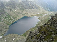
Lake "Veľké Hincovo pleso" in High Tatras, Slovakia. The lake occupies an "overdeepening" carved by flowing ice that once occupied this glacial valley.

Other than some notable exceptions in antiquity, geomorphology is a relatively young science, growing along with interest in other aspects of the earth sciences in the mid-19th century. This section provides a very brief outline of some of the major figures and events in its development.

Ancient geomorphology

The study of landforms and the evolution of the Earth's surface can be dated back to scholars of Classical Greece. Herodotus argued from observations of soils that the Nile delta was actively growing into the Mediterranean Sea, and estimated its age. Aristotle speculated that due to sediment transport into the sea, eventually those seas would fill while the land lowered. He claimed that this would mean that land and water would eventually swap places, whereupon the process would begin again in an endless cycle.

Another early theory of geomorphology was devised by the polymath Chinese scientist and statesman Shen Kuo (1031–1095 AD). This was based on his observation of marine fossil shells in a geological stratum of a mountain hundreds of miles from the Pacific Ocean. Noticing bivalve shells running in a horizontal span along the cut section of a cliffside, he theorized that the cliff was once the pre-historic location of a seashore that had shifted hundreds of miles over the centuries. He inferred that the land was reshaped and formed by soil erosion of the mountains and by deposition of silt, after observing strange natural erosions of the Taihang Mountains and the Yandang Mountain near Wenzhou. Furthermore, he promoted the theory of gradual climate change over centuries of time once ancient petrified bamboos were found to be preserved underground in the dry, northern climate zone of Yanzhou, which is now modern day Yan'an, Shaanxi province.

Early modern geomorphology

The term geomorphology seems to have been first used by Laumann in an 1858 work written in German. Keith Tinkler has suggested that the word came into general use in English, German and French after John Wesley Powell and W. J. McGee used it during the International Geological Conference of 1891. John Edward Marr in his The Scientific Study of Scenery considered his book as, 'an Introductory Treatise on Geomorphology, a subject which has sprung from the union of Geology and Geography'.

An early popular geomorphic model was the geographical cycle or cycle of erosion model of broad-scale landscape evolution developed by William Morris Davis between 1884 and 1899. It was an elaboration of the uniformitarianism theory that had first been proposed by James Hutton (1726–1797). With regard to valley forms, for example, uniformitarianism posited a sequence in which a river runs through a flat terrain, gradually carving an increasingly deep valley, until the side valleys eventually erode, flattening the terrain again, though at a lower elevation. It was thought that tectonic uplift could then start the cycle over. In the decades following Davis's development of this idea, many of those studying geomorphology sought to fit their findings into this framework, known today as "Davisian". Davis's ideas are of historical importance, but have been largely superseded today, mainly due to their lack of predictive power and qualitative nature.

In the 1920s, Walther Penck developed an alternative model to Davis's. Penck thought that landform evolution was better described as an alternation between ongoing processes of uplift and denudation, as opposed to Davis's model of a single uplift followed by decay. He also emphasised that in many landscapes slope evolution occurs by backwearing of rocks, not by Davisian-style surface lowering, and his science tended to emphasise surface process over understanding in detail the surface history of a given locality. Penck was German, and during his lifetime his ideas were at times rejected vigorously by the English-speaking geomorphology community. His early death, Davis' dislike for his work, and his at-times-confusing writing style likely all contributed to this rejection.

Both Davis and Penck were trying to place the study of the evolution of the Earth's surface on a more generalized, globally relevant footing than it had been previously. In the early 19th century, authors – especially in Europe – had tended to attribute the form of landscapes to local climate, and in particular to the specific effects of glaciation and periglacial processes. In contrast, both Davis and Penck were seeking to emphasize the importance of evolution of landscapes through time and the generality of the Earth's surface processes across different landscapes under different conditions.

During the early 1900s, the study of regional-scale geomorphology was termed "physiography". Physiography later was considered to be a contraction of "physical" and "geography", and therefore synonymous with physical geography, and the concept became embroiled in controversy surrounding the appropriate concerns of that discipline. Some geomorphologists held to a geological basis for physiography and emphasized a concept of physiographic regions while a conflicting trend among geographers was to equate physiography with "pure morphology", separated from its geological heritage.[citation needed] In the period following World War II, the emergence of process, climatic, and quantitative studies led to a preference by many earth scientists for the term "geomorphology" in order to suggest an analytical approach to landscapes rather than a descriptive one.

Climatic geomorphology

During the age of New Imperialism in the late 19th century European explorers and scientists traveled across the globe bringing descriptions of landscapes and landforms. As geographical knowledge increased over time these observations were systematized in a search for regional patterns. Climate emerged thus as prime factor for explaining landform distribution at a grand scale. The rise of climatic geomorphology was foreshadowed by the work of Wladimir Köppen, Vasily Dokuchaev and Andreas Schimper. William Morris Davis, the leading geomorphologist of his time, recognized the role of climate by complementing his "normal" temperate climate cycle of erosion with arid and glacial ones. Nevertheless, interest in climatic geomorphology was also a reaction against Davisian geomorphology that was by the mid-20th century considered both un-innovative and dubious. Early climatic geomorphology developed primarily in continental Europe while in the English-speaking world the tendency was not explicit until L.C. Peltier's 1950 publication on a periglacial cycle of erosion.

Climatic geomorphology was criticized in a 1969 review article by process geomorphologist D.R. Stoddart. The criticism by Stoddart proved "devastating" sparking a decline in the popularity of climatic geomorphology in the late 20th century. Stoddart criticized climatic geomorphology for applying supposedly "trivial" methodologies in establishing landform differences between morphoclimatic zones, being linked to Davisian geomorphology and by allegedly neglecting the fact that physical laws governing processes are the same across the globe. In addition some conceptions of climatic geomorphology, like that which holds that chemical weathering is more rapid in tropical climates than in cold climates proved to not be straightforwardly true.

Quantitative and process geomorphology

Part of the Great Escarpment in the Drakensberg, southern Africa. This landscape, with its high altitude plateau being incised into by the steep slopes of the escarpment, was cited by Davis as a classic example of his cycle of erosion.

Geomorphology was started to be put on a solid quantitative footing in the middle of the 20th century. Following the early work of Grove Karl Gilbert around the turn of the 20th century, a group of mainly American natural scientists, geologists and hydraulic engineers including William Walden Rubey, Ralph Alger Bagnold, Hans Albert Einstein, Frank Ahnert, John Hack, Luna Leopold, A. Shields, Thomas Maddock, Arthur Strahler, Stanley Schumm, and Ronald Shreve began to research the form of landscape elements such as rivers and hillslopes by taking systematic, direct, quantitative measurements of aspects of them and investigating the scaling of these measurements. These methods began to allow prediction of the past and future behavior of landscapes from present observations, and were later to develop into the modern trend of a highly quantitative approach to geomorphic problems. Many groundbreaking and widely cited early geomorphology studies appeared in the Bulletin of the Geological Society of America, and received only few citations prior to 2000 (they are examples of "sleeping beauties") when a marked increase in quantitative geomorphology research occurred.

Quantitative geomorphology can involve fluid dynamics and solid mechanics, geomorphometry, laboratory studies, field measurements, theoretical work, and full landscape evolution modeling. These approaches are used to understand weathering and the formation of soils, sediment transport, landscape change, and the interactions between climate, tectonics, erosion, and deposition.

In Sweden Filip Hjulström's doctoral thesis, "The River Fyris" (1935), contained one of the first quantitative studies of geomorphological processes ever published. His students followed in the same vein, making quantitative studies of mass transport (Anders Rapp), fluvial transport (Åke Sundborg), delta deposition (Valter Axelsson), and coastal processes (John O. Norrman). This developed into "the Uppsala School of Physical Geography".

Contemporary geomorphology

Today, the field of geomorphology encompasses a very wide range of different approaches and interests. Modern researchers aim to draw out quantitative "laws" that govern Earth surface processes, but equally, recognize the uniqueness of each landscape and environment in which these processes operate. Particularly important realizations in contemporary geomorphology include:

1) that not all landscapes can be considered as either "stable" or "perturbed", where this perturbed state is a temporary displacement away from some ideal target form. Instead, dynamic changes of the landscape are now seen as an essential part of their nature.

2) that many geomorphic systems are best understood in terms of the stochasticity of the processes occurring in them, that is, the probability distributions of event magnitudes and return times. This in turn has indicated the importance of chaotic determinism to landscapes, and that landscape properties are best considered statistically. The same processes in the same landscapes do not always lead to the same end results.

Albeit having its importance diminished climatic geomorphology continues to exist as field of study producing relevant research. More recently concerns over global warming have led to a renewed interest in the field.

Despite considerable criticism the cycle of erosion model has remained part of the science of geomorphology. The model or theory has never been proved wrong, but neither has it been proven. The inherent difficulties of the model have instead made geomorphological research to advance along other lines. In contrast to its disputed status in geomorphology, the cycle of erosion model is a common approach used to establish denudation chronologies, and is thus an important concept in the science of historical geology. While acknowledging its shortcomings modern geomorphologists Andrew Goudie and Karna Lidmar-Bergström have praised it for its elegance and pedagogical value respectively.

Processes

Gorge cut by the Indus river into bedrock, Nanga Parbat region, Pakistan. This is the deepest river canyon in the world. Nanga Parbat itself, the world's 9th highest mountain, is seen in the background.

Geomorphically relevant processes generally fall into (1) the production of regolith by weathering and erosion, (2) the transport of that material, and (3) its eventual deposition. Primary surface processes responsible for most topographic features include wind, waves, chemical dissolution, mass wasting, groundwater movement, surface water flow, glacial action, tectonism, and volcanism. Other more exotic geomorphic processes might include periglacial (freeze-thaw) processes, salt-mediated action, marine currents activity, seepage of fluids through the seafloor or extraterrestrial impact.

Aeolian processes

Wind-eroded alcove near Moab, Utah

Aeolian processes pertain to the activity of the winds and more specifically, to the winds' ability to shape the surface of the Earth. Winds may erode, transport, and deposit materials, and are effective agents in regions with sparse vegetation and a large supply of fine, unconsolidated sediments.  Although water and mass flow tend to mobilize more material than wind in most environments, aeolian processes are important in arid environments such as deserts.

Biological processes

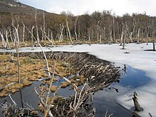
Beaver dams, as this one in Tierra del Fuego, constitute a specific form of zoogeomorphology, a type of biogeomorphology.

The interaction of living organisms with landforms, or biogeomorphologic processes, can be of many different forms, and is probably of profound importance for the terrestrial geomorphic system as a whole. Biology can influence very many geomorphic processes, ranging from biogeochemical processes controlling chemical weathering, to the influence of mechanical processes like burrowing and tree throw on soil development, to even controlling global erosion rates through modulation of climate through carbon dioxide balance. Terrestrial landscapes in which the role of biology in mediating surface processes can be definitively excluded are extremely rare, but may hold important information for understanding the geomorphology of other planets, such as Mars.

Fluvial processes

Seif and barchan dunes in the Hellespontus region on the surface of Mars. Dunes are mobile landforms created by the transport of large volumes of sand by wind.

Rivers and streams are not only conduits of water, but also of sediment. The water, as it flows over the channel bed, is able to mobilize sediment and transport it downstream, either as bed load, suspended load or dissolved load. The rate of sediment transport depends on the availability of sediment itself and on the river's discharge. Rivers are also capable of eroding into rock and creating new sediment, both from their own beds and also by coupling to the surrounding hillslopes. In this way, rivers are thought of as setting the base level for large-scale landscape evolution in nonglacial environments. Rivers are key links in the connectivity of different landscape elements.

As rivers flow across the landscape, they generally increase in size, merging with other rivers. The network of rivers thus formed is a drainage system. These systems take on four general patterns: dendritic, radial, rectangular, and trellis. Dendritic happens to be the most common, occurring when the underlying stratum is stable (without faulting). Drainage systems have four primary components: drainage basin, alluvial valley, delta plain, and receiving basin. Some geomorphic examples of fluvial landforms are alluvial fans, oxbow lakes, and fluvial terraces.

Glacial processes

Features of a glacial landscape

Glaciers, while geographically restricted, are effective agents of landscape change. The gradual movement of ice down a valley causes abrasion and plucking of the underlying rock. Abrasion produces fine sediment, termed glacial flour. The debris transported by the glacier, when the glacier recedes, is termed a moraine. Glacial erosion is responsible for U-shaped valleys, as opposed to the V-shaped valleys of fluvial origin.

The way glacial processes interact with other landscape elements, particularly hillslope and fluvial processes, is an important aspect of Plio-Pleistocene landscape evolution and its sedimentary record in many high mountain environments. Environments that have been relatively recently glaciated but are no longer may still show elevated landscape change rates compared to those that have never been glaciated. Nonglacial geomorphic processes which nevertheless have been conditioned by past glaciation are termed paraglacial processes. This concept contrasts with periglacial processes, which are directly driven by formation or melting of ice or frost.

Hillslope processes

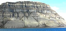
Talus cones on the north shore of Isfjorden, Svalbard, Norway. Talus cones are accumulations of coarse hillslope debris at the foot of the slopes producing the material.

Soil, regolith, and rock move downslope under the force of gravity via creep, slides, flows, topples, and falls. Such mass wasting occurs on both terrestrial and submarine slopes, and has been observed on Earth, Mars, Venus, Titan and Iapetus.

Ongoing hillslope processes can change the topology of the hillslope surface, which in turn can change the rates of those processes. Hillslopes that steepen up to certain critical thresholds are capable of shedding extremely large volumes of material very quickly, making hillslope processes an extremely important element of landscapes in tectonically active areas.

On the Earth, biological processes such as burrowing or tree throw may play important roles in setting the rates of some hillslope processes.

Igneous processes

Both volcanic (eruptive) and plutonic (intrusive) igneous processes can have important impacts on geomorphology. The action of volcanoes tends to rejuvenize landscapes, covering the old land surface with lava and tephra, releasing pyroclastic material and forcing rivers through new paths. The cones built by eruptions also build substantial new topography, which can be acted upon by other surface processes. Plutonic rocks intruding then solidifying at depth can cause both uplift or subsidence of the surface, depending on whether the new material is denser or less dense than the rock it displaces.

Tectonic processes

Tectonic effects on geomorphology can range from scales of millions of years to minutes or less. The effects of tectonics on landscape are heavily dependent on the nature of the underlying bedrock fabric that more or less controls what kind of local morphology tectonics can shape. Earthquakes can, in terms of minutes, submerge large areas of land creating new wetlands. Isostatic rebound can account for significant changes over hundreds to thousands of years, and allows erosion of a mountain belt to promote further erosion as mass is removed from the chain and the belt uplifts. Long-term plate tectonic dynamics give rise to orogenic belts, large mountain chains with typical lifetimes of many tens of millions of years, which form focal points for high rates of fluvial and hillslope processes and thus long-term sediment production.

Features of deeper mantle dynamics such as plumes and delamination of the lower lithosphere have also been hypothesised to play important roles in the long term (> million year), large scale (thousands of km) evolution of the Earth's topography (see dynamic topography). Both can promote surface uplift through isostasy as hotter, less dense, mantle rocks displace cooler, denser, mantle rocks at depth in the Earth.[48][49]

Marine processes

Marine processes are those associated with the action of waves, marine currents and seepage of fluids through the seafloor. Mass wasting and submarine landsliding are also important processes for some aspects of marine geomorphology. Because ocean basins are the ultimate sinks for a large fraction of terrestrial sediments, depositional processes and their related forms (e.g., sediment fans, deltas) are particularly important as elements of marine geomorphology.

Scales

Different geomorphological processes dominate at different spatial and temporal scales. Moreover, scales on which processes occur may determine the reactivity or otherwise of landscapes to changes in driving forces such as climate or tectonics. These ideas are key to the study of geomorphology today.

To help categorize landscape scales some geomorphologists might use the following taxonomy:

Overlap with other fields

There is a considerable overlap between geomorphology and other fields. Deposition of material is extremely important in sedimentology. Weathering is the chemical and physical disruption of earth materials in place on exposure to atmospheric or near surface agents, and is typically studied by soil scientists and environmental chemists, but is an essential component of geomorphology because it is what provides the material that can be moved in the first place. Civil and environmental engineers are concerned with erosion and sediment transport, especially related to canals, slope stability (and natural hazards), water quality, coastal environmental management, transport of contaminants, and stream restoration. Glaciers can cause extensive erosion and deposition in a short period of time, making them extremely important entities in the high latitudes and meaning that they set the conditions in the headwaters of mountain-born streams; glaciology therefore is important in geomorphology.

Crust (geology)

From Wikipedia, the free encyclopedia

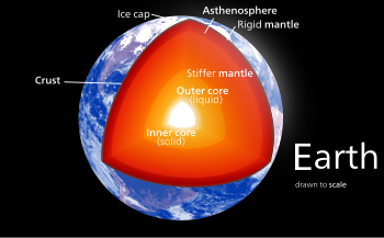
The internal structure of Earth

In geology, the crust is the outermost solid shell of a rocky planet, dwarf planet, or natural satellite. It is usually distinguished from the underlying mantle by its chemical makeup; however, in the case of icy satellites, it may be distinguished based on its phase (solid crust vs. liquid mantle).

The crusts of Earth, Moon, Mercury, Venus, Mars, Io, and other planetary bodies formed via igneous processes, and were later modified by erosion, impact cratering, volcanism, and sedimentation.

Most terrestrial planets have fairly uniform crusts. Earth, however, has two distinct types: continental crust and oceanic crust. These two types have different chemical compositions and physical properties, and were formed by different geological processes.

Types of crust

Planetary geologists divide crust into three categories, based on how and when they formed.

Primary crust / primordial crust

This is a planet's "original" crust. It forms from solidification of a magma ocean. Toward the end of planetary accretion, the terrestrial planets likely had surfaces that were magma oceans. As these cooled, they solidified into crust. This crust was likely destroyed by large impacts and re-formed many times as the Era of Heavy Bombardment drew to a close.

The nature of primary crust is still debated: its chemical, mineralogic, and physical properties are unknown, as are the igneous mechanisms that formed them. This is because it is difficult to study: none of Earth's primary crust has survived to today. Earth's high rates of erosion and crustal recycling from plate tectonics has destroyed all rocks older than about 4 billion years, including whatever primary crust Earth once had.

However, geologists can glean information about primary crust by studying it on other terrestrial planets. Mercury's highlands might represent primary crust, though this is debated. The anorthosite highlands of the Moon are primary crust, formed as plagioclase crystallized out of the Moon's initial magma ocean and floated to the top; however, it is unlikely that Earth followed a similar pattern, as the Moon was a water-less system and Earth had water. The Martian meteorite ALH84001 might represent primary crust of Mars; however, again, this is debated. Like Earth, Venus lacks primary crust, as the entire planet has been repeatedly resurfaced and modified.

Secondary crust

Secondary crust is formed by partial melting of silicate materials in the mantle, and so is usually basaltic in composition.

This is the most common type of crust in the Solar System. Most of the surfaces of Mercury, Venus, Earth, and Mars comprise secondary crust, as do the lunar maria. On Earth, we see secondary crust forming primarily at mid-ocean spreading centers, where the adiabatic rise of mantle causes partial melting.

Tertiary crust

Tertiary crust is more chemically-modified than either primary or secondary. It can form in several ways:
  • Igneous processes: partial-melting of secondary crust, coupled with differentiation or dehydration
  • Erosion and sedimentation: sediments derived from primary, secondary, or tertiary crust
The only known example of tertiary crust is the continental crust of the Earth. It is unknown whether other terrestrial planets can be said to have tertiary crust, though the evidence so far suggests that they do not. This is likely because plate tectonics is needed to create tertiary crust, and Earth is the only planet in our Solar System with plate tectonics.

Earth's crust

Structure

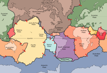
Plates in the crust of Earth

The crust is a thin shell on the outside of the Earth, accounting for less than 1% of Earth's volume. It is the top component of lithosphere: a division of Earth's layers that includes the crust and the upper part of the mantle. The lithosphere is broken into tectonic plates that move, allowing heat to escape from the interior of the Earth into space.

The crust lies on top of the mantle, a configuration that is stable because the upper mantle is made of peridotite and so is significantly denser than the crust. The boundary between the crust and mantle is conventionally placed at the Mohorovičić discontinuity, a boundary defined by a contrast in seismic velocity.

Geologic provinces of the world (USGS
 

The crust of the Earth is of two distinctive types:
  1. Oceanic: 5 km (3 mi) to 10 km (6 mi) thick and composed primarily of denser, more mafic rocks, such as basalt, diabase, and gabbro.
  2. Continental: 30 km (20 mi) to 50 km (30 mi) thick and mostly composed of less dense, more felsic rocks, such as granite.
Because both continental and oceanic crust are less dense than the mantle below, both types of crust "float" on the mantle. This is isostasy, and it's also one of the reasons continental crust is higher than oceanic: continental is less dense and so "floats" higher. As a result, water pools in above the oceanic crust, forming the oceans.

The temperature of the crust increases with depth, reaching values typically in the range from about 200 °C (392 °F) to 400 °C (752 °F) at the boundary with the underlying mantle. The temperature increases by as much as 30 °C (54 °F) for every kilometer locally in the upper part of the crust, but the geothermal gradient is smaller in deeper crust.

Composition

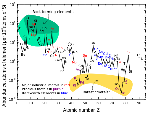
Abundance (atom fraction) of the chemical elements in
Earth's upper continental crust as a function of atomic number.
The rarest elements in the crust (shown in yellow) are not the
heaviest, but are rather the siderophile (iron-loving) elements
in the Goldschmidt classification of elements. These have been
depleted by being relocated deeper into Earth's core. Their
abundance in meteoroid materials is higher. Additionally,
tellurium and selenium have been depleted from the crust due
to formation of volatile hydrides.

The continental crust has an average composition similar to that of andesite. The most abundant minerals in Earth's continental crust are feldspars, which make up about 41% of the crust by weight, followed by quartz at 12%, and pyroxenes at 11%. Continental crust is enriched in incompatible elements compared to the basaltic ocean crust and much enriched compared to the underlying mantle. Although the continental crust comprises only about 0.6 weight percent of the silicate on Earth, it contains 20% to 70% of the incompatible elements.


All the other constituents except water occur only in very small quantities and total less than 1%. Estimates of average density for the upper crust range between 2.69 and 2.74 g/cm3 and for lower crust between 3.0 and 3.25 g/cm3.

Formation and evolution

Earth formed approximately 4.6 billion years ago from a disk of dust and gas orbiting the newly formed Sun. It formed via accretion, where planetesimals and other smaller rocky bodies collided and stuck, gradually growing into a planet. This process generated an enormous amount of heat, which caused early Earth to melt completely. As planetary accretion slowed, Earth began to cool, forming its first crust, called a primary or primordial crust. This crust was likely repeatedly destroyed by large impacts, then reformed from the magma ocean left by the impact. None of Earth's primary crust has survived to today; all was destroyed by erosion, impacts, and plate tectonics over the past several billion years.

Since then, Earth has been forming secondary and tertiary crust. Secondary crust forms at mid-ocean spreading centers, where partial-melting of the underlying mantle yields basaltic magmas and new ocean crust forms. This "ridge push" is one of the driving forces of plate tectonics, and it is constantly creating new ocean crust. That means that old crust must be destroyed somewhere, so, opposite a spreading center, there is usually a subduction zone: a trench where an ocean plate is being shoved back into the mantle. This constant process of creating new ocean crust and destroying old ocean crust means that the oldest ocean crust on Earth today is only about 200 million years old.

In contrast, the bulk of the continental crust is much older. The oldest continental crustal rocks on Earth have ages in the range from about 3.7 to 4.28  billion years  and have been found in the Narryer Gneiss Terrane in Western Australia, in the Acasta Gneiss in the Northwest Territories on the Canadian Shield, and on other cratonic regions such as those on the Fennoscandian Shield. Some zircon with age as great as 4.3 billion years has been found in the Narryer Gneiss Terrane.

The average age of the current Earth's continental crust has been estimated to be about 2.0 billion years. Most crustal rocks formed before 2.5 billion years ago are located in cratons. Such old continental crust and the underlying mantle asthenosphere are less dense than elsewhere in Earth and so are not readily destroyed by subduction. Formation of new continental crust is linked to periods of intense orogeny; these periods coincide with the formation of the supercontinents such as Rodinia, Pangaea and Gondwana. The crust forms in part by aggregation of island arcs including granite and metamorphic fold belts, and it is preserved in part by depletion of the underlying mantle to form buoyant lithospheric mantle.

Moon's crust

A theoretical protoplanet named "Theia" is thought to have collided with the forming Earth, and part of the material ejected into space by the collision accreted to form the Moon. As the Moon formed, the outer part of it is thought to have been molten, a “lunar magma ocean.” Plagioclase feldspar crystallized in large amounts from this magma ocean and floated toward the surface. The cumulate rocks form much of the crust. The upper part of the crust probably averages about 88% plagioclase (near the lower limit of 90% defined for anorthosite): the lower part of the crust may contain a higher percentage of ferromagnesian minerals such as the pyroxenes and olivine, but even that lower part probably averages about 78% plagioclase. The underlying mantle is denser and olivine-rich.

The thickness of the crust ranges between about 20 and 120 km. Crust on the far side of the Moon averages about 12 km thicker than that on the near side. Estimates of average thickness fall in the range from about 50 to 60 km. Most of this plagioclase-rich crust formed shortly after formation of the moon, between about 4.5 and 4.3 billion years ago. Perhaps 10% or less of the crust consists of igneous rock added after the formation of the initial plagioclase-rich material. The best-characterized and most voluminous of these later additions are the mare basalts formed between about 3.9 and 3.2 billion years ago. Minor volcanism continued after 3.2 billion years, perhaps as recently as 1 billion years ago. There is no evidence of plate tectonics.

Study of the Moon has established that a crust can form on a rocky planetary body significantly smaller than Earth. Although the radius of the Moon is only about a quarter that of Earth, the lunar crust has a significantly greater average thickness. This thick crust formed almost immediately after formation of the Moon. Magmatism continued after the period of intense meteorite impacts ended about 3.9 billion years ago, but igneous rocks younger than 3.9 billion years make up only a minor part of the crust.

Myth of superabundance

From Wikipedia, the free encyclopedia
The myth of superabundance is the belief that earth has more than sufficient natural resources to satisfy humanity's needs, and that no matter how much of these resources humanity uses, the planet will continuously replenish the supply. Although the idea had existed previously among conservationists in the 19th century, it was not given a name until Stewart Udall's 1964 book The Quiet Crisis.

Udall describes the myth as the belief that there was "so much land, so much water, so much timber, so many birds and beasts" that man did not envision a time where the planet would not replenish what had been sowed. The myth of superabundance began to circulate during Thomas Jefferson's presidency at the beginning of the nineteenth century and persuaded many Americans to exploit natural resources as they pleased with no thought of long-term consequences. According to historian of the North American west George Colpitts, "No theme became as integral to western promotion as natural abundance." Especially with respect to the west after 1890, promotional literature encouraged migration by invoking the idea that God had provided an abundant environment there such that no man or family would fail if they sought to farm or otherwise live off the land out west. Since at that time environmental science and the study of ecology barely allowed for the possibility of animal extinction and did not provide tools for measuring biomass or the limits of natural resources, many speculators, settlers, and other parties participated in unsustainable practices that led to various extinctions, the Dust Bowl phenomenon, and other environmental catastrophes.

Early manifestations

In 1784, John Filson wrote The Discovery, Settlement And present State of Kentucke, which included the chapter "The Adventures of Colonel Daniel Boon". This work represents one of the earliest instance of the myth of superabundance, acting as something of a promotional ad enticing settlers to Kentucky based on the abundance of resources to be found there.

Warning signs

Udall describes many large-scale impacts on natural resources, terming them "The Big Raid on resources". The first was the need for lumber in a growing nation for fuel, housing and paper. Udall states that it was with this first big raid on the earth’s natural resources that the myth of superabundance began to show its fallacy. It was only towards the end of the nineteenth century that people were awakened to the empty hillsides and the vastness of blackened woods from the lumber industry. Petroleum followed, as it was widely believed that oil was constantly made inside the earth, and so, like everything else, was inexhaustible. Then came seal hunting, and by 1866 the seal population that originally numbered approximately five million was drastically cut in half. Many of the seals were shot in the water and never recovered, allowing for enormous waste. The Fur Seal Treaty which came about in 1911 saved the seals from becoming the first major marine species to become extinct thanks to the myth of superabundance.

The passenger pigeon was the largest wildlife species known to humanity in the early nineteenth century, when the bird's population was estimated at about five billion. By the early 20th century, due to overhunting and habitat destruction brought about by the timber industry, the species had become extinct, the last passenger pigeon having died in the Cincinnati Zoo. The passenger pigeon became extinct in under a century and was just one of the many victims of the myth of superabundance.

Likewise, the American buffalo was threatened by the myth of superabundance. They were considered to be the largest and most valuable resource because just about every piece of them was usable. The big kill of the buffalo began at the end of the Civil War when armies wanted the animals killed in order to starve out the Plains Indians. Railroad men wanted them killed in order to supply heavier and profitable loads of hides. Buffalo were killed for their tongues and hides, and some hunters simply wanted them as trophies. Pleas of protection for the buffalo were ignored, nearly wiping out the species.

The Great Leap Forward in China in 1958 corresponded closely with the myth of superabundance; economic planners reduced the acreage space for planting wheat and grains, trying to force farmers and agricultural labourers into accepting new forms of industry. As a result, production of wheat and grain was slowed dangerously, and floods in the South and droughts in the North struck in 1959, leading China into the record-breaking Great Chinese Famine.

The myth exposed

George Perkins Marsh, who wrote Man and Nature in 1864, rejected the idea that any resource could be exploited without any concerns for the future. Perkins was a witness to natural destruction; he saw that mistakes of the past were destroying the present prosperity. He believed that nature should be second nature to all and should not be used as an exploitation for economics and politics. He was, after all, "forest born". Man's role as a catalyst of change in the natural world intrigued him. He believed that progress was entirely possible and necessary, if only men used wisdom in the management of resources. He deflated, but did not destroy the myth of superabundance. He began the spin into doubt, which made way for John Muir in 1874. Muir, who had grown up surrounded by wilderness, believed that wildlife and nature could provide people with heightened sense abilities and experiences of awe that could be found nowhere else. Entering into civilization with a desire to see preservation of some of what he believed to be America’s most beautiful nature, he built upon steps that had been taken by Frederick Law Olmsted, a young landscape architect who designed Central Park in New York City. Olmsted had persuaded Congress to pass a bill preserving much of Yosemite Valley, which President Lincoln had then approved in 1864. In 1872 President Grant signed the Yellowstone Park bill, saving over two million acres of wildlife.

Early successes

Muir saw overgrazing destruction in Yosemite, in parts of it that were not under protection. It was a result of nearby sheepmen and their herds. In 1876, Muir wrote an article "God’s First Temples – How Shall We Preserve Our Forests", which he published in the newspaper, pleading for help with protection of the forests. At first he failed against the overriding ideal of the myth of superabundance, but he did inspire bills in the 1880s that sought to enlarge Yosemite’s reservation. Muir formed the Sierra Club, a group of mountaineers and conservationists like him who had responded to his many articles. The Sierra Club’s first big fight came as a counter-attack on lumbermen and stockmen who wanted to monopolize some of Yosemite County. Yosemite Valley, which was still owned by the state, was mismanaged and natural reserves like the meadows and Mirror Lake, which was dammed for irrigation, were still being destroyed even under supposed protection. In 1895, Muir and the Sierra Club began a battle that would span over ten years, fighting for natural management of Yosemite Valley. Theodore Roosevelt met with Muir in 1903 and was instantly fascinated with Muir’s passion for the wilderness. Roosevelt approved Muir’s argument for Yosemite Valley, and so the Sierra Club took their decade long campaign to Sacramento, where they finally won against California legislature in 1905. With Roosevelt on Muir’s side, Yosemite Valley finally became part of the Yosemite National Park and was allowed natural management.

Moving backwards

Udall asserts that the myth of superabundance, once exposed, was replaced in the 20th century by the myth of scientific supremacy: the belief that science can eventually find a solution to any problem. This leads to behaviors which, while recognizing that resources are not infinite, still fail to properly preserve those resources, putting the problem off to future generations to solve through science. "Present the repair bill to the next generation" is their silent motto. George Perkins Marsh had said that conservation's greatest enemies were "greed and shortsightedness". Men reach a power trip thinking they can manipulate nature the way that they want.

Next steps

In order for man to live harmoniously with nature, as Muir and Perkins and many others have fought for, Patsy Hallen in the article, "The Art of Impurity" says that an ethics development must occur in which respect for nature and our radical dependency on it can take place. Humans see themselves as superior to nature, and yet we are in a constant state of continuity with it. Hallen argues that humanity cannot afford such an irrational state of mind and ecological denial if it expects to prosper in the future.

Ecocide

From Wikipedia, the free encyclopedia
Ecocide, or ecocatastrophe, is the extensive damage to, destruction of or loss of ecosystem(s) of a given territory, whether by human agency or by other, to such an extent that peaceful enjoyment by the inhabitants of that territory has been or will be severely diminished. Ecocide may have been previously used to refer to a very potent pesticide, particularly 1080 (sodium fluoroacetate).

Anthropogenic ecocide

The term ecocide is more recently used to refer to the destructive impact of humanity on its own natural environment. As a group of complex organisms we are committing ecocide through unsustainable exploitation of the planet's resources. The geological era we are living in, known as the anthropocene, is so named because the activities of the human species are influencing the Earth's natural state in a way never seen before. The most notable example is that of the atmosphere which is being transformed through the emission of gases from fossil fuel use : carbon dioxide, methane, chlorofluorocarbons etc. The ecocide we are witnessing is a symptom of the disregard and reward for accounting for the damage being caused. U.S. environmental theorist and activist Patrick Hossay  argues that the human species is committing ecocide, via industrial civilization's effects on the global environment. Much of the modern environmental movement stems from this belief as a precept.

Ecocide as a proposed international crime

The concept of ecocide as an international crime originated in the 1970s.

In 2010 it was proposed that the Rome Statute be amended to include the international crime of Ecocide. The proposal was submitted to the United Nations International Law Commission who are '‘'mandated to promote the progressive development of international law and its codification’. The definition proposed includes provisions for both individual and state responsibility and would be a strict liability crime(including both intent and negligence). It would create a duty of care in events of naturally occurring ecocide as well as creating criminal responsibility for human caused ecocide.

Severity of environmental harm

To be considered an ecocide under the proposed law, an environmental harm would need to be widespread, long lasting or severe. This is the parameter based disjunctive test, as already set out under the 1977 United Nations Convention on Environmental Modification, which specifies the terms ‘widespread’, ‘long-lasting’ or ‘severe’ as:
  1. widespread: encompassing an area on the scale of several hundred square kilometers; and/or
  2. long-lasting: lasting for a period of months, or approximately a season; and/or
  3. severe: involving serious or significant disruption or harm to human life, natural and economic resources or other assets. 

History

1970
 
The word was recorded at the Conference on War and National Responsibility in Washington 1970, where Arthur Galston proposed a new international agreement to ban ecocide. Galston was a US biologist who identified the defoliant effects of a chemical later developed into Agent Orange. Subsequently a bioethicist, he was the first in 1970 to name massive damage and destruction of ecosystems as an ecocide.

In an obiter dictum in the 1970 Barcelona Traction case judgement, the International Court of Justice identified a category of international obligations called erga omnes, namely obligations owed by states to the international community as a whole, intended to protect and promote the basic values and common interests of all.

1972
 
In 1972 at the United Nations Stockholm Conference on the Human Environment which adopted the Stockholm Declaration, Olof Palme the Prime Minister of Sweden, in his opening speech spoke explicitly of the Vietnam war as an ecocide and it was discussed in the unofficial events running parallel to the official UN Stockholm Conference on Human Environment. Others, including Indira Gandhi from India and Tang Ke, the leader of the Chinese delegation, also denounced the war in human and environmental terms. They too called for ecocide to be an international crime[citation needed]. A Working Group on Crimes Against the Environment was formed at the conference, and a draft Ecocide Convention was submitted into the United Nations in 1973.

Dai Dong, a branch of the International Fellowship of Reconciliation sponsored a Convention on Ecocidal War which took place in Stockholm, Sweden. The Convention brought together many people including experts Richard A. Falk, expert on the international law of war crimes and Robert Jay Lifton, a psychohistorian. The Convention called for a United Nations Convention on Ecocidal Warfare, which would amongst other matters seek to define and condemn ecocide as an international crime of war. Richard A. Falk drafted an Ecocide Convention in 1973, explicitly stating at the outset to recognise "that man has consciously and unconsciously inflicted irreparable damage to the environment in times of war and peace".

Westing's view was that the element of intent did not always apply. "Intent may not only be impossible to establish without admission but, I believe, it is essentially irrelevant."

1978

Draft Code of Crimes Against the Peace and Security of Mankind discussions commence. At the same time, State responsibility and international crimes are discussed and drafted.

The ILC 1978 Yearbook's 'Draft articles on State Responsibility and International Crime' included: "an international crime (which) may result, inter alia, from: (d) a serious breach of an international obligation of essential importance for the safeguarding and preservation of the human environment, such as those prohibiting massive pollution of the atmosphere or of the seas." Supporters who spoke out in favour of a crime of ecocide included Romania and the Holy See, Austria, Poland, Rwanda, Congo and Oman

1985

Ecocide as a crime continued to be addressed. The Whitaker Report, commissioned by the Sub-Commission on the Promotion and Protection of Human Rights on the question of the prevention and punishment of the crime of genocide was prepared by then Special Rapporteur, Benjamin Whitaker. The report contained a passage that "some members of the Sub-Commission have, however, proposed that the definition of genocide should be broadened to include cultural genocide or "ethnocide", and also "ecocide": adverse alterations, often irreparable, to the environment - for example through nuclear explosions, chemical weapons, serious pollution and acid rain, or destruction of the rain forest - which threaten the existence of entire populations, whether deliberately or with criminal negligence."

1987

Discussion of international crimes continued in the International Law Commission, where it was proposed that "the list of international crimes include "ecocide", as a reflection of the need to safeguard and preserve the environment, as well as the first use of nuclear weapons, colonialism, apartheid, economic aggression and mercenarism".

1991

The ILC 'Draft Code of Crimes Against the Peace and Security of Mankind' of 1991 contained 12 crimes. One of those was 'wilful damage to the environment (Article 26)'.

1993

As of 29 March 1993, the Secretary-General had received 23 replies from Member States and one reply from a non-member State. They were: Australia, Austria, Belarus, Belgium, Brazil, Bulgaria, Costa Rica, Ecuador, Greece, Netherlands, the Nordic countries (Denmark, Finland, Iceland, Norway, Sweden), Paraguay, Poland, Senegal, Sudan, Turkey, UK, USA, Uruguay and Switzerland. Many objections were raised, for summarised commentary see the 1993 ILC Yearbook. Only three countries, the Netherlands, the United Kingdom and the United States of America, opposed the inclusion of an environmental crime. The issue of adding a high test of intent (‘wilful’) was of concern: Austria commented: "Since perpetrators of this crime are usually acting out of a profit motive, intent should not be a condition for liability to punishment." Belgium and Uruguay also took the position that no element of intent was necessary for the crime of severe damage to the environment (Article 26).

1996

In 1996, Canadian/Australian lawyer Mark Gray published his proposal for an international crime of ecocide, based on established international environmental and human rights law. He demonstrated that states, and arguably individuals and organisations, causing or permitting harm to the natural environment on a massive scale breach a duty of care owed to humanity in general. He proposed that such breaches, where deliberate, reckless or negligent, be identified as ecocide where they entail serious, and extensive or lasting, ecological damage; international consequences; and waste.

Meanwhile, in the ILC, ‘wilful and severe damage to the environment’ (Article 26) had been tasked to a working-group: "The Commission further decided that consultations would continue as regards [Article 26] …the Commission decided … to establish a working group that would meet … to examine the possibility of covering in the draft Code the issue of wilful and severe damage to the environment ... the Commission decided by a vote to refer to the Drafting Committee only the text prepared by the working group for inclusion of wilful and severe damage to the environment as a war crime. "

1998

The final Draft Code was used as inspiration for the Rome Statute at the United Nations United Nations Diplomatic Conference of Plenipotentiaries on the Establishment of an International Criminal Court, which was held in Rome. The Rome Statute was the founding document of the International Criminal Court (ICC), to be used when a state is either unwilling or unable to bring their own prosecutions for international crimes.

Ecocide was not included in the Rome Statute as a separate crime, but featured in relation to a war-crime. The test for this war crime was narrower than previous proposed tests. Under the Environmental Modification Convention 1977 (ENMOD) the test for war-time environmental destruction is ‘widespread, long-term or severe’, whereas Article 8(2)(b) of the Rome Statute 1998 modified the ENMOD test with the change of one word to ‘widespread, long-term and severe.’ Article 8(2)(b) limited environmental harm to circumstances when "Intentionally launching an attack in the knowledge that such attack will cause incidental loss of life or injury to civilians or damage to civilian objects or widespread, long-term and severe damage to the natural environment which would be clearly excessive in relation to the concrete and direct overall military advantage anticipated."

2010

The proposal for the crime of Ecocide was submitted to the United Nations by a private party. In March 2010, British "earth lawyer" Polly Higgins submitted to the United Nations an amendment to the Rome Statute, proposing that “ecocide” be legally recognised as the fifth international Crime against peace. The Rome Statute currently acknowledges four crimes against peace: genocide; crimes against humanity; war crimes; and the crime of aggression. Each of these crimes affects human victims. While Higgins’ proposed definition of ecocide attends to inhabitants’ “peaceful enjoyment”, the victim the amendment is primarily promising to protect is not human but environmental.

2011

A mock Ecocide Act was drafted and then tested in the UK Supreme Court via a mock trial by the Hamilton Group.

2012

A concept paper on the Law of Ecocide was sent out to governments In June 2012 the idea of making ecocide a crime was presented to legislators and judges from around the world at the World Congress on Justice Governance and Law for Environmental Sustainability, held in Mangaratiba before the Rio +20 Earth Summit, the United Nations Conference on Sustainable Development. Making ecocide an international crime was voted as one of the top twenty solutions to achieving sustainable development at the World Youth Congress in Rio de Janeiro in June 2012.

In October 2012 a range of experts gathered at the international conference Environmental Crime: Current and Emerging Threats[40] held in Rome at the UN Food and Agricultural Organization Headquarters hosted by the United Nations Interregional Crime and Justice Research Institute(UNICRI) in cooperation with United Nations Environmental Programme (UNEP) and the Ministry of the Environment (Italy). The conference recognized that environmental crime is an important new form of transnational organized crime in need a greater response. One of the outcomes was that UNEP and UNICRI head up a study into the definition of environmental crime, new environmental crime and give due consideration to the history of making ecocide an international crime once again.

2013 - 2014
European citizen Initiative for criminalising ecocide

On January 22, 2013, a committee of eleven citizens from nine EU countries officially launched the "European Citizens Initiative "End Ecocide in Europe". The European Citizens' Initiative, or ECI, is a tool created by the Lisbon Treaty to promote participative and direct democracy. The ECI is a way for EU citizens to propose new or suggest amendments to legislation directly to the European Commission which is the institution proposing new EU laws. This initiative aimed at criminalising ecocide, the extensive damage and destruction of ecosystems, including the denial of market access for products based on ecocide to the EU and investments in activities causing ecocide. Three MEPs, Keith Taylor, Eva Joly, and Jo Leinen, publicly gave the first signatures. The initiative did not collect the 1 million signatures needed, but was discussed in the European Parliament.

Existing domestic ecocide laws

Ten countries have codified ecocide as a crime during peacetime. Those countries follow closely the ILC Draft articles definition of "An individual who wilfully causes or orders the causing of widespread, long-term and severe damage to the natural environment shall, on conviction thereof, be sentenced [to...]." Although there are Laws of Ecocide in place, the effectiveness of these laws depends on a number of factors including the enforcement of the law, an independent judiciary and respect for the rule of law. Many of the countries with national laws of ecocide in place are ranked very highly for corruption and low for respect for the rule of law by Transparency International.

Georgia 1999

Article 409. Ecocide: "Ecocide, i.e. contamination of atmosphere, land and water resources, mass destruction of flora and fauna or any other action that could have caused ecological disaster - shall be punishable by ..."

Armenia 2003

Article 394. Ecocide: "Mass destruction of flora or fauna, poisoning the environment, the soils or water resources, as well as implementation of other actions causing an ecological catastrophe, is punished ..."

Ukraine 2001

Article 441. Ecocide: "Mass destruction of flora and fauna, poisoning of air or water resources, and also any other actions that may cause an environmental disaster, - shall be punishable by ..."

Belarus 1999

Art 131. Ecocide: "Deliberate mass destruction of flora and fauna, or poisoning the air or water, or the commission of other intentional acts that could cause an ecological disaster (ecocide), - shall be punished by ..."

Kazakhstan 1997

Art 161. Ecocide: "Mass destruction of flora or fauna, poisoning the atmosphere, land or water resources, as well as the commission of other acts which caused or a capable of causation of an ecological catastrophe, - shall be punished by..."

Kyrgyzstan 1997

Art 374. Ecocide: "Massive destruction of the animal or plant kingdoms, contamination of the atmosphere or water resources, and also commission of other actions capable of causing an ecological catastrophe, shall be punishable ..."

Republic of Moldova 2002

Art 136. Ecocide: "Deliberate mass destruction of flora and fauna, poisoning the atmosphere or water resources, and the commission of other acts that may cause or caused an ecological disaster shall be punished ..."

Russian Federation 1996

Art 358. Ecocide: "Massive destruction of the animal or plant kingdoms, contamination of the atmosphere or water resources, and also commission of other actions capable of causing an ecological catastrophe, shall be punishable by ..."

Tajikistan 1998

Art 400. Ecocide: "Mass destruction of flora and fauna, poisoning the atmosphere or water resources, as well as commitment of other actions which may cause ecological disasters is punishable ..."

Uzbekistan 1994

Art 196. Pollution of Natural Environment: "Pollution or damage of land, water, or atmospheric air, resulted in mass disease incidence of people, death of animals, birds, or fish, or other grave consequences – shall be punished ..."

Vietnam 1990

Art 342 Crimes against mankind: "Those who, in peace time or war time, commit acts of ... as well as other acts of genocide or acts of ecocide or destroying the natural environment, shall be sentenced ..."

Education

From Wikipedia, the free encyclopedia https://en.wikipedia.org/wiki/Education Education is the transmissio...