Search This Blog

Sunday, December 17, 2023

Stone tool

From Wikipedia, the free encyclopedia

A stone tool is, in the most general sense, any tool made either partially or entirely out of stone. Although stone tool-dependent societies and cultures still exist today, most stone tools are associated with prehistoric (particularly Stone Age) cultures that have become extinct. Archaeologists often study such prehistoric societies, and refer to the study of stone tools as lithic analysis. Ethnoarchaeology has been a valuable research field in order to further the understanding and cultural implications of stone tool use and manufacture.

Stone has been used to make a wide variety of different tools throughout history, including arrowheads, spearheads, hand axes, and querns. Stone tools may be made of either ground stone or knapped stone, the latter fashioned by a flintknapper.

Knapped stone tools are made from cryptocrystalline materials such as chert or flint, radiolarite, chalcedony, obsidian, basalt, and quartzite via a process known as lithic reduction. One simple form of reduction is to strike stone flakes from a nucleus (core) of material using a hammerstone or similar hard hammer fabricator. If the goal of the reduction strategy is to produce flakes, the remnant lithic core may be discarded once it has become too small to use. In some strategies, however, a flintknapper reduces the core to a rough unifacial, or bifacial preform, which is further reduced using soft hammer flaking techniques or by pressure flaking the edges.

More complex forms of reduction include the production of highly standardized blades, which can then be fashioned into a variety of tools such as scrapers, knives, sickles, and microliths. In general terms, Knapped stone tools are nearly ubiquitous in all pre-metal-using societies because they are easily manufactured, the tool stone is usually plentiful, and they are easy to transport and sharpen.

Evolution

A selection of prehistoric stone tools

Archaeologists classify stone tools into industries (also known as complexes or technocomplexes) that share distinctive technological or morphological characteristics.

In 1969 in the 2nd edition of World Prehistory, Grahame Clark proposed an evolutionary progression of flint-knapping in which the "dominant lithic technologies" occurred in a fixed sequence from Mode 1 through Mode 5. He assigned to them relative dates: Modes 1 and 2 to the Lower Palaeolithic, 3 to the Middle Palaeolithic, 4 to the Upper Paleolithic, and 5 to the Mesolithic, though there were other lithic technologies outside these Modes. Each region had its own timeline for the succession of the Modes: for example, Mode 1 was in use in Europe long after it had been replaced by Mode 2 in Africa.

Clark's scheme was adopted enthusiastically by the archaeological community. One of its advantages was the simplicity of terminology; for example, the Mode 1 / Mode 2 Transition. The transitions are currently of greatest interest. Consequently, in the literature the stone tools used in the period of the Palaeolithic are divided into four "modes", each of which designates a different form of complexity, and which in most cases followed a rough chronological order.

Pre-Mode I

Kenya

Stone tools found from 2011 to 2014 at the Lomekwi archeology site near Lake Turkana in Kenya, are dated to be 3.3 million years old, and predate the genus Homo by about one million years. The oldest known Homo fossil is about 2.4-2.3 million years old compared to the 3.3 million year old stone tools. The stone tools may have been made by Australopithecus afarensis, the species whose best fossil example is Lucy, which inhabited East Africa at the same time as the date of the oldest stone tools, a yet unidentified species, or by Kenyanthropus platyops (a 3.2 to 3.5-million-year-old Pliocene hominin fossil discovered in 1999). Dating of the tools was done by dating volcanic ash layers in which the tools were found and dating the magnetic signature (pointing north or south due to reversal of the magnetic poles) of the rock at the site.

Ethiopia

Grooved, cut and fractured animal bone fossils, made by using stone tools, were found in Dikika, Ethiopia near (200 yards) the remains of Selam, a young Australopithecus afarensis girl who lived about 3.3 million years ago.

Mode I: The Oldowan Industry

A typical Oldowan simple chopping-tool. This example is from the Duero Valley, Valladolid.

The earliest stone tools in the era of genus Homo are Mode 1 tools, and come from what has been termed the Oldowan Industry, named after the type of site (many sites, actually) found in Olduvai Gorge, Tanzania, where they were discovered in large quantities. Oldowan tools were characterised by their simple construction, predominantly using core forms. These cores were river pebbles, or rocks similar to them, that had been struck by a spherical hammerstone to cause conchoidal fractures removing flakes from one surface, creating an edge and often a sharp tip. The blunt end is the proximal surface; the sharp, the distal. Oldowan is a percussion technology. Grasping the proximal surface, the hominid brought the distal surface down hard on an object he wished to detach or shatter, such as a bone or tuber. Experiments with modern humans found that all four Oldowan knapping techniques can be invented by knapping-naive participants, and that the resulting Oldowan tools were used by the experiment participants to access a money-baited box. 

The earliest known Oldowan tools yet found date from 2.6 million years ago, during the Lower Palaeolithic period, and have been uncovered at Gona in Ethiopia. After this date, the Oldowan Industry subsequently spread throughout much of Africa, although archaeologists are currently unsure which Hominan species first developed them, with some speculating that it was Australopithecus garhi, and others believing that it was in fact Homo habilis. Homo habilis was the hominin who used the tools for most of the Oldowan in Africa, but at about 1.9-1.8 million years ago Homo erectus inherited them. The Industry flourished in southern and eastern Africa between 2.6 and 1.7 million years ago, but was also spread out of Africa and into Eurasia by travelling bands of H. erectus, who took it as far east as Java by 1.8 million years ago and Northern China by 1.6 million years ago.

Mode II: The Acheulean Industry

A biface (trihedral) from Amar Merdeg, Zagros foothills, Lower Paleolithic, National Museum of Iran
A typical Acheulean handaxe (from the Duero valley in Spain). The small flakes on the edge are from reworking.

Eventually, more complex Mode 2 tools began to be developed through the Acheulean Industry, named after the site of Saint-Acheul in France. The Acheulean was characterised not by the core, but by the biface, the most notable form of which was the hand axe. The Acheulean first appears in the archaeological record as early as 1.7 million years ago in the West Turkana area of Kenya and contemporaneously in southern Africa.

The Leakeys, excavators at Olduvai, defined a "Developed Oldowan" Period in which they believed they saw evidence of an overlap in Oldowan and Acheulean. In their species-specific view of the two industries, Oldowan equated to H. habilis and Acheulean to H. erectus. Developed Oldowan was assigned to habilis and Acheulean to erectus. Subsequent dates on H. erectus pushed the fossils back to well before Acheulean tools; that is, H. erectus must have initially used Mode 1. There was no reason to think, therefore, that Developed Oldowan had to be habilis; it could have been erectus. Opponents of the view divide Developed Oldowan between Oldowan and Acheulean. There is no question, however, that habilis and erectus coexisted, as habilis fossils are found as late as 1.4 million years ago. Meanwhile, African H. erectus developed Mode 2. In any case a wave of Mode 2 then spread across Eurasia, resulting in use of both there. H. erectus may not have been the only hominin to leave Africa; European fossils are sometimes associated with Homo ergaster, a contemporary of H. erectus in Africa.

In contrast to an Oldowan tool, which is the result of a fortuitous and probably unplanned operation to obtain one sharp edge on a stone, an Acheulean tool is a planned result of a manufacturing process. The manufacturer begins with a blank, either a larger stone or a slab knocked off a larger rock. From this blank he or she removes large flakes, to be used as cores. Standing a core on edge on an anvil stone, he or she hits the exposed edge with centripetal blows of a hard hammer to roughly shape the implement. Then the piece must be worked over again, or retouched, with a soft hammer of wood or bone to produce a tool finely Knapped all over consisting of two convex surfaces intersecting in a sharp edge. Such a tool is used for slicing; concussion would destroy the edge and cut the hand.

Some Mode 2 tools are disk-shaped, others ovoid, others leaf-shaped and pointed, and others elongated and pointed at the distal end, with a blunt surface at the proximal end, obviously used for drilling. Mode 2 tools are used for butchering; not being composite (having no haft) they are not very appropriate killing instruments. The killing must have been done some other way. Mode 2 tools are larger than Oldowan. The blank was ported to serve as an ongoing source of flakes until it was finally retouched as a finished tool itself. Edges were often sharpened by further retouching.

Mode III: The Mousterian Industry

A tool made by the Levallois technique. This example is from La Parrilla (Valladolid, Spain).

Eventually, the Acheulean in Europe was replaced by a lithic technology known as the Mousterian Industry, which was named after the site of Le Moustier in France, where examples were first uncovered in the 1860s. Evolving from the Acheulean, it adopted the Levallois technique to produce smaller and sharper knife-like tools as well as scrapers. Also known as the "prepared core technique", flakes are struck from worked cores and then subsequently retouched. The Mousterian Industry was developed and used primarily by the Neanderthals, a native European and Middle Eastern hominin species, but a broadly similar industry is contemporaneously widespread in Africa.

Mode IV: The Aurignacian Industry

The widespread use of long blades (rather than flakes) of the Upper Palaeolithic Mode 4 industries appeared during the Upper Palaeolithic between 50,000 and 10,000 years ago, although blades were produced in small quantities much earlier by Neanderthals. The Aurignacian culture seems to have been the first to rely largely on blades. The use of blades exponentially increases the efficiency of core usage compared to the Levallois flake technique, which had a similar advantage over Acheulean technology which was worked from cores.

Mode V: The Microlithic Industries

The most widely accepted hypothesis is that geometric microliths were used on projectiles such as this harpoon.
Trapezoid microliths and arrow with a trapeze used to strengthen the tip, found in a peat bog at Tværmose (Denmark)
 

Mode 5 stone tools involve the production of microliths, which were used in composite tools, mainly fastened to a shaft. Examples include the Magdalenian culture. Such a technology makes much more efficient use of available materials like flint, although required greater skill in manufacturing the small flakes. Mounting sharp flint edges in a wood or bone handle is the key innovation in microliths, essentially because the handle gives the user protection against the flint and also improves leverage of the device.

Neolithic industries
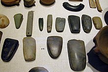
An array of Neolithic artifacts, including bracelets, axe heads, chisels, and polishing tools.
Polished Neolithic jadeitite axe from the Museum of Toulouse
Axe heads found at a 2700 BC Neolithic manufacture site in Switzerland, arranged in the various stages of production from left to right

In prehistoric Japan, ground stone tools appear during the Japanese Paleolithic period, that lasted from around 40,000 BC to 14,000 BC. Elsewhere, ground stone tools became important during the Neolithic period beginning about 10,000 BC. These ground or polished implements are manufactured from larger-grained materials such as basalt, jade and jadeite, greenstone and some forms of rhyolite which are not suitable for flaking. The greenstone industry was important in the English Lake District, and is known as the Langdale axe industry. Ground stone implements included adzes, celts, and axes, which were manufactured using a labour-intensive, time-consuming method of repeated grinding against an abrasive stone, often using water as a lubricant. Because of their coarse surfaces, some ground stone tools were used for grinding plant foods and were polished not just by intentional shaping, but also by use. Manos are hand stones used in conjunction with metates for grinding corn or grain. Polishing increased the intrinsic mechanical strength of the axe. Polished stone axes were important for the widespread clearance of woods and forest during the Neolithic period, when crop and livestock farming developed on a large scale. They are distributed very widely and were traded over great distances since the best rock types were often very local. They also became venerated objects, and were frequently buried in long barrows or round barrows with their former owners.

During the Neolithic period, large axes were made from flint nodules by knapping a rough shape, a so-called "rough-out". Such products were traded across a wide area. The rough-outs were then polished to give the surface a fine finish to create the axe head. Polishing not only increased the final strength of the product but also meant that the head could penetrate wood more easily. There were many sources of supply, including Grimes Graves in Suffolk, Cissbury in Sussex and Spiennes near Mons in Belgium to mention but a few. In Britain, there were numerous small quarries in downland areas where flint was removed for local use, for example.

Many other rocks were used to make axes from stones, including the Langdale axe industry as well as numerous other sites such as Penmaenmawr and Tievebulliagh in Co Antrim, Ulster. In Langdale, there many outcrops of the greenstone were exploited, and knapped where the stone was extracted. The sites exhibit piles of waste flakes, as well as rejected rough-outs. Polishing improved the mechanical strength of the tools, so increasing their life and effectiveness. Many other tools were developed using the same techniques. Such products were traded across the country and abroad.

Aboriginal Australian use

Stone axes from 35,000 years ago are the earliest known use of a stone tool in Australia. Other stone tools varied in type and use among various Aboriginal Australian peoples, dependent on geographical regions and the type and structure of the tools varied among the different cultural and linguistic groups. The locations of the various artefacts, as well as whole geologic features, demarcated territorial and cultural boundaries of various linguistic and cultural groups' lands. They developed trade networks, and showed sophistication in working many different types of stone for many different uses, including as tools, food utensils and weapons, and modified their stone tools over the millennia to adapt to changing environments. Oral traditions carried the skills down through the ages.

Complex stone tools were used by the Gunditjmara of western Victoria until relatively recently. Many examples are now held in museums.

Flaked stone tools were made by extracting a sharp fragment of stone from a larger piece, called a core, by hitting it with a "hammerstone". Both the flakes and the hammerstones could be used as tools. The best types of stone for these tools are hard, brittle stones, rich in silica, such as quartzite, chert, flint, silcrete and quartz (the latter particularly in the Kimberleys of Western Australia). These were quarried from bedrock or collected as pebbles from watercourses and beaches, and often carried for long distances. The flake could be used immediately for cutting or scraping, but were sometimes modified in a process called reduction to sharpen or resharpen the flake.

Across northern Australia, especially in Arnhem Land, the "Leilira blade", a rectangular stone flake shaped by striking quartzite or silcrete stone, was used as a spear tip and also as a knife, sometimes 30 cm (12 in) long. Tasmania did not have spears or stone axes, but the peoples there used tools which were adapted to the climate and environment, such as the use of spongolite. In north-western Australia, "Kimberley point", a small triangular stone point, was created using kangaroo bone which had been shaped with stone into an awl, to make small serrations in the blade.

Apart from being used as weapons and for cutting, grinding (grindstones), piercing and pounding, some stones, notably ochres, were used as pigment for painting.

Modern uses

Stone tools are still one of the most successful technologies used by humans.

The invention of the flintlock gun mechanism in the sixteenth century produced a demand for specially shaped gunflints. The gunflint industry survived until the middle of the twentieth century in some places, including in the English town of Brandon.

Threshing boards with lithic flakes are used in agriculture from Neolithic, and are still used today in the regions where agriculture has not been mechanized and industrialized.

Glassy stones (flint, quartz, jasper, agate) were used with a variety of iron pyrite or marcasite stones as percussion fire starter tools. That was the most common method of producing fire in pre-industrial societies. Stones were later superseded by use of steel, ferrocerium and matches.

For specialist purposes glass knives are still made and used today, particularly for cutting thin sections for electron microscopy in a technique known as microtomy. Freshly cut blades are always used since the sharpness of the edge is very great. These knives are made from high-quality manufactured glass, however, not from natural raw materials such as chert or obsidian. Surgical knives made from obsidian are still used in some delicate surgeries, as they cause less damage to tissues than surgical knives and the resulting wounds heal more quickly. In 1975, American archaeologist Don Crabtree manufactured obsidian scalpels which were used for surgery on his own body.

Tool stone

In archaeology, a tool stone is a type of stone that is used to manufacture stone tools.


Rock (geology)

From Wikipedia, the free encyclopedia
https://en.wikipedia.org/wiki/Rock_(geology)
The Grand Canyon, an incision through layers of sedimentary rocks.

In geology, rock (or stone) is any naturally occurring solid mass or aggregate of minerals or mineraloid matter. It is categorized by the minerals included, its chemical composition, and the way in which it is formed. Rocks form the Earth's outer solid layer, the crust, and most of its interior, except for the liquid outer core and pockets of magma in the asthenosphere. The study of rocks involves multiple subdisciplines of geology, including petrology and mineralogy. It may be limited to rocks found on Earth, or it may include planetary geology that studies the rocks of other celestial objects.

Rocks are usually grouped into three main groups: igneous rocks, sedimentary rocks and metamorphic rocks. Igneous rocks are formed when magma cools in the Earth's crust, or lava cools on the ground surface or the seabed. Sedimentary rocks are formed by diagenesis and lithification of sediments, which in turn are formed by the weathering, transport, and deposition of existing rocks. Metamorphic rocks are formed when existing rocks are subjected to such high pressures and temperatures that they are transformed without significant melting.

Humanity has made use of rocks since the earliest humans. This early period, called the Stone Age, saw the development of many stone tools. Stone was then used as a major component in the construction of buildings and early infrastructure. Mining developed to extract rocks from the Earth and obtain the minerals within them, including metals. Modern technology has allowed the development of new man-made rocks and rock-like substances, such as concrete.

Study

Geology is the study of Earth and its components, including the study of rock formations. Petrology is the study of the character and origin of rocks. Mineralogy is the study of the mineral components that create rocks. The study of rocks and their components has contributed to the geological understanding of Earth's history, the archaeological understanding of human history, and the development of engineering and technology in human society.

While the history of geology includes many theories of rocks and their origins that have persisted throughout human history, the study of rocks was developed as a formal science during the 19th century. Plutonism was developed as a theory during this time, and the discovery of radioactive decay in 1896 allowed for the radiocarbon dating of rocks. Understanding of plate tectonics developed in the second half of the 20th century.

Classification

A balancing rock called Kummakivi (literally "strange stone")[3]

Rocks are composed primarily of grains of minerals, which are crystalline solids formed from atoms chemically bonded into an orderly structure. Some rocks also contain mineraloids, which are rigid, mineral-like substances, such as volcanic glass, that lacks crystalline structure. The types and abundance of minerals in a rock are determined by the manner in which it was formed.

Most rocks contain silicate minerals, compounds that include silica tetrahedra in their crystal lattice, and account for about one-third of all known mineral species and about 95% of the earth's crust. The proportion of silica in rocks and minerals is a major factor in determining their names and properties.

Rock outcrop along a mountain creek near Orosí, Costa Rica.

Rocks are classified according to characteristics such as mineral and chemical composition, permeability, texture of the constituent particles, and particle size. These physical properties are the result of the processes that formed the rocks. Over the course of time, rocks can be transformed from one type into another, as described by a geological model called the rock cycle. This transformation produces three general classes of rock: igneous, sedimentary and metamorphic.

Those three classes are subdivided into many groups. There are, however, no hard-and-fast boundaries between allied rocks. By increase or decrease in the proportions of their minerals, they pass through gradations from one to the other; the distinctive structures of one kind of rock may thus be traced, gradually merging into those of another. Hence the definitions adopted in rock names simply correspond to selected points in a continuously graduated series.

Igneous rock

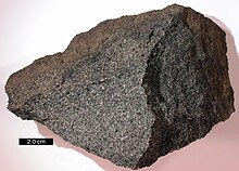
Sample of igneous gabbro

Igneous rock (derived from the Latin word igneus, meaning of fire, from ignis meaning fire) is formed through the cooling and solidification of magma or lava. This magma may be derived from partial melts of pre-existing rocks in either a planet's mantle or crust. Typically, the melting of rocks is caused by one or more of three processes: an increase in temperature, a decrease in pressure, or a change in composition.

Igneous rocks are divided into two main categories:

Magmas tend to become richer in silica as they rise towards the Earth's surface, a process called magma differentiation. This occurs both because minerals low in silica crystallize out of the magma as it begins to cool (Bowen's reaction series) and because the magma assimilates some of the crustal rock through which it ascends (country rock), and crustal rock tends to be high in silica. Silica content is thus the most important chemical criterion for classifying igneous rock. The content of alkali metal oxides is next in importance.

About 65% of the Earth's crust by volume consists of igneous rocks. Of these, 66% are basalt and gabbro, 16% are granite, and 17% granodiorite and diorite. Only 0.6% are syenite and 0.3% are ultramafic. The oceanic crust is 99% basalt, which is an igneous rock of mafic composition. Granite and similar rocks, known as granitoids, dominate the continental crust.

Sedimentary rock

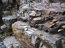
Sedimentary sandstone with iron oxide bands

Sedimentary rocks are formed at the earth's surface by the accumulation and cementation of fragments of earlier rocks, minerals, and organisms or as chemical precipitates and organic growths in water (sedimentation). This process causes clastic sediments (pieces of rock) or organic particles (detritus) to settle and accumulate or for minerals to chemically precipitate (evaporite) from a solution. The particulate matter then undergoes compaction and cementation at moderate temperatures and pressures (diagenesis).

Before being deposited, sediments are formed by weathering of earlier rocks by erosion in a source area and then transported to the place of deposition by water, wind, ice, mass movement or glaciers (agents of denudation). About 7.9% of the crust by volume is composed of sedimentary rocks, with 82% of those being shales, while the remainder consists of 6% limestone and 12% sandstone and arkoses. Sedimentary rocks often contain fossils. Sedimentary rocks form under the influence of gravity and typically are deposited in horizontal or near horizontal layers or strata, and may be referred to as stratified rocks.

Sediment and the particles of clastic sedimentary rocks can be further classified by grain size. The smallest sediments are clay, followed by silt, sand, and gravel. Some systems include cobbles and boulders as measurements.

Metamorphic rock

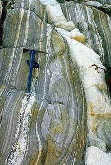
Metamorphic banded gneiss

Metamorphic rocks are formed by subjecting any rock type—sedimentary rock, igneous rock or another older metamorphic rock—to different temperature and pressure conditions than those in which the original rock was formed. This process is called metamorphism, meaning to "change in form". The result is a profound change in physical properties and chemistry of the stone. The original rock, known as the protolith, transforms into other mineral types or other forms of the same minerals, by recrystallization. The temperatures and pressures required for this process are always higher than those found at the Earth's surface: temperatures greater than 150 to 200 °C and pressures greater than 1500 bars. This occurs, for example, when continental plates collide. Metamorphic rocks compose 27.4% of the crust by volume.

The three major classes of metamorphic rock are based upon the formation mechanism. An intrusion of magma that heats the surrounding rock causes contact metamorphism—a temperature-dominated transformation. Pressure metamorphism occurs when sediments are buried deep under the ground; pressure is dominant, and temperature plays a smaller role. This is termed burial metamorphism, and it can result in rocks such as jade. Where both heat and pressure play a role, the mechanism is termed regional metamorphism. This is typically found in mountain-building regions.

Depending on the structure, metamorphic rocks are divided into two general categories. Those that possess a texture are referred to as foliated; the remainders are termed non-foliated. The name of the rock is then determined based on the types of minerals present. Schists are foliated rocks that are primarily composed of lamellar minerals such as micas. A gneiss has visible bands of differing lightness, with a common example being the granite gneiss. Other varieties of foliated rock include slates, phyllites, and mylonite. Familiar examples of non-foliated metamorphic rocks include marble, soapstone, and serpentine. This branch contains quartzite—a metamorphosed form of sandstone—and hornfels.

Extraterrestrial rocks

Though most understanding of rocks comes from those of Earth, rocks make up many of the universe's celestial bodies. In the Solar System, Mars, Venus, and Mercury are composed of rock, as are many natural satellites, asteroids, and meteoroids. Meteorites that fall to Earth provide evidence of extraterrestrial rocks and their composition. They are typically heavier than rocks on Earth. Asteroid rocks can also be brought to Earth through space missions, such as the Hayabusa mission. Lunar rocks and Martian rocks have also been studied.

Human use

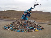
Ceremonial cairn of rocks, an ovoo, from Mongolia

The use of rock has had a huge impact on the cultural and technological development of the human race. Rock has been used by humans and other hominids for at least 2.5 million years. Lithic technology marks some of the oldest and continuously used technologies. The mining of rock for its metal content has been one of the most important factors of human advancement, and has progressed at different rates in different places, in part because of the kind of metals available from the rock of a region.

Anthropic rock

Anthropic rock is synthetic or restructured rock formed by human activity. Concrete is recognized as a human-made rock constituted of natural and processed rock and having been developed since Ancient Rome. Rock can also be modified with other substances to develop new forms, such as epoxy granite. Artificial stone has also been developed, such as Coade stone. Geologist James R. Underwood has proposed anthropic rock as a fourth class of rocks alongside igneous, sedimentary, and metamorphic.

Building

A stonehouse on the hill in Sastamala, Finland
Raised garden bed with natural stones

Rock varies greatly in strength, from quartzites having a tensile strength in excess of 300 MPa to sedimentary rock so soft it can be crumbled with bare fingers (that is, it is friable). (For comparison, structural steel has a tensile strength of around 350 MPa.) Relatively soft, easily worked sedimentary rock was quarried for construction as early as 4000 BCE in Egypt, and stone was used to build fortifications in Inner Mongolia as early as 2800 BCE. The soft rock, tuff, is common in Italy, and the Romans used it for many buildings and bridges. Limestone was widely used in construction in the Middle Ages in Europe  and remained popular into the 20th century.

Mining

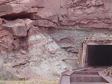
Mi Vida uranium mine near Moab, Utah

Mining is the extraction of valuable minerals or other geological materials from the earth, from an ore body, vein or seam. The term also includes the removal of soil. Materials recovered by mining include base metals, precious metals, iron, uranium, coal, diamonds, limestone, oil shale, rock salt, potash, construction aggregate and dimension stone. Mining is required to obtain any material that cannot be grown through agricultural processes, or created artificially in a laboratory or factory. Mining in a wider sense comprises extraction of any resource (e.g. petroleum, natural gas, salt or even water) from the earth.

Mining of rock and metals has been done since prehistoric times. Modern mining processes involve prospecting for mineral deposits, analysis of the profit potential of a proposed mine, extraction of the desired materials, and finally reclamation of the land to prepare it for other uses once mining ceases.

Mining processes may create negative impacts on the environment both during the mining operations and for years after mining has ceased. These potential impacts have led to most of the world's nations adopting regulations to manage negative effects of mining operations.

Tools

Stone tools have been used for millions of years by humans and earlier hominids. The Stone Age was a period of widespread stone tool usage. Early Stone Age tools were simple implements, such as hammerstones and sharp flakes. Middle Stone Age tools featured sharpened points to be used as projectile points, awls, or scrapers. Late Stone Age tools were developed with craftsmanship and distinct cultural identities. Stone tools were largely superseded by copper and bronze tools following the development of metallurgy.

Map

From Wikipedia, the free encyclopedia
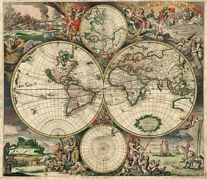
World map by Gerard van Schagen, Amsterdam, 1689
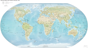
World map from CIA World Factbook, 2016

A map is a symbolic depiction emphasizing relationships between elements of some space, such as objects, regions, or themes.

Many maps are static, fixed to paper or some other durable medium, while others are dynamic or interactive. Although most commonly used to depict geography, maps may represent any space, real or fictional, without regard to context or scale, such as in brain mapping, DNA mapping, or computer network topology mapping. The space being mapped may be two dimensional, such as the surface of the Earth, three dimensional, such as the interior of the Earth, or even more abstract spaces of any dimension, such as arise in modeling phenomena having many independent variables.

Although the earliest maps known are of the heavens, geographic maps of territory have a very long tradition and exist from ancient times. The word "map" comes from the medieval Latin: Mappa mundi, wherein mappa meant 'napkin' or 'cloth' and mundi 'the world'. Thus, "map" became a shortened term referring to a two-dimensional representation of the surface of the world.

History

Tabula Rogeriana, one of the most advanced early world maps, by Muhammad al-Idrisi, 1154

The history of cartography traces the development of cartography, or mapmaking technology, in human history. Maps have been one of the most important human inventions for millennia, allowing humans to explain and navigate their way through the world. The earliest surviving maps include cave paintings and etchings on tusk and stone, followed by extensive maps produced by ancient Babylon, Greece and Rome, China, and India. In their most simple form maps are two dimensional constructs, however since the age of Classical Greece maps have also been projected onto a three-dimensional sphere known as a globe. The Mercator Projection, developed by Flemish geographer Gerardus Mercator, was widely used as the standard two-dimensional projection of the earth for world maps until the late 20th century, when more accurate projections were formulated. Mercator was also the first to use and popularise the concept of the atlas as a collection of maps.

Geography

Celestial map by the cartographer Frederik de Wit, 17th century

Cartography or map-making is the study and practice of crafting representations of the Earth upon a flat surface (see History of cartography), and one who makes maps is called a cartographer.

Road maps are perhaps the most widely used maps today, and form a subset of navigational maps, which also include aeronautical and nautical charts, railroad network maps, and hiking and bicycling maps. In terms of quantity, the largest number of drawn map sheets is probably made up by local surveys, carried out by municipalities, utilities, tax assessors, emergency services providers, and other local agencies. Many national surveying projects have been carried out by the military, such as the British Ordnance Survey: a civilian government agency, internationally renowned for its comprehensively detailed work.

In addition to location information, maps may also be used to portray contour lines indicating constant values of elevation, temperature, rainfall, etc.

Orientation

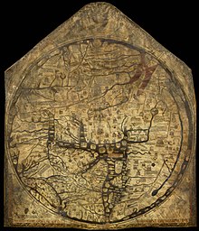
The Hereford Mappa Mundi, Hereford Cathedral, England, circa 1300, a classic "T-O" map with Jerusalem at the center, east toward the top, Europe the bottom left and Africa on the right

The orientation of a map is the relationship between the directions on the map and the corresponding compass directions in reality. The word "orient" is derived from Latin oriens, meaning east. In the Middle Ages many maps, including the T and O maps, were drawn with east at the top (meaning that the direction "up" on the map corresponds to East on the compass). The most common cartographic convention is that north is at the top of a map.

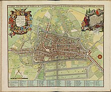
Map of Utrecht, Netherlands (1695).

Maps not oriented with north at the top:

  • Medieval European T and O maps such as the Hereford Mappa Mundi were centered on Jerusalem with East at the top. Indeed, before the reintroduction of Ptolemy's Geography to Europe around 1400, there was no single convention in the West. Portolan charts, for example, are oriented to the shores they describe.
  • Maps of cities bordering a sea are often conventionally oriented with the sea at the top.
  • Route and channel maps have traditionally been oriented to the road or waterway they describe.
  • Polar maps of the Arctic or Antarctic regions are conventionally centered on the pole; the direction North would be toward or away from the center of the map, respectively. Typical maps of the Arctic have 0° meridian toward the bottom of the page; maps of the Antarctic have the 0° meridian toward the top of the page.
  • South-up maps invert the North is up convention by having south at the top. Ancient Africans including in Ancient Egypt used this orientation, as some maps in Brazil do today.
  • Buckminster Fuller's Dymaxion maps are based on a projection of the Earth's sphere onto an icosahedron. The resulting triangular pieces may be arranged in any order or orientation.
  • Using the equator as the edge, the world map of Gott, Vanderbei, and Goldberg is arranged as a pair of disks back-to-back designed to present the least error possible. They are designed to be printed as a two-sided flat object that could be held easily for educational purposes.

Scale and accuracy

Many maps are drawn to a scale expressed as a ratio, such as 1:10,000, which means that 1 unit of measurement on the map corresponds to 10,000 of that same unit on the ground. The scale statement can be accurate when the region mapped is small enough for the curvature of the Earth to be neglected, such as a city map. Mapping larger regions, where the curvature cannot be ignored, requires projections to map from the curved surface of the Earth to the plane. The impossibility of flattening the sphere to the plane without distortion means that the map cannot have a constant scale. Rather, on most projections, the best that can be attained is an accurate scale along one or two paths on the projection. Because scale differs everywhere, it can only be measured meaningfully as point scale per location. Most maps strive to keep point scale variation within narrow bounds. Although the scale statement is nominal it is usually accurate enough for most purposes unless the map covers a large fraction of the earth. At the scope of a world map, scale as a single number is practically meaningless throughout most of the map. Instead, it usually refers to the scale along the equator.

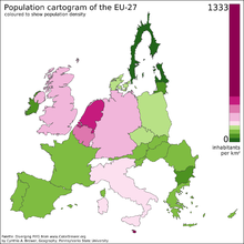
Cartogram of the EU – distorted to show population distributions as of 2008

Some maps, called cartograms, have the scale deliberately distorted to reflect information other than land area or distance. For example, this map (at the left) of Europe has been distorted to show population distribution, while the rough shape of the continent is still discernible.

Another example of distorted scale is the famous London Underground map. The basic geographical structure is respected but the tube lines (and the River Thames) are smoothed to clarify the relationships between stations. Near the center of the map, stations are spaced out more than near the edges of the map.

Further inaccuracies may be deliberate. For example, cartographers may simply omit military installations or remove features solely to enhance the clarity of the map. For example, a road map may not show railroads, smaller waterways, or other prominent non-road objects, and even if it does, it may show them less clearly (e.g. dashed or dotted lines/outlines) than the main roads. Known as decluttering, the practice makes the subject matter that the user is interested in easier to read, usually without sacrificing overall accuracy. Software-based maps often allow the user to toggle decluttering between ON, OFF, and AUTO as needed. In AUTO the degree of decluttering is adjusted as the user changes the scale being displayed.

Projection

Geographic maps use a projection to translate the three-dimensional real surface of the geoid to a two-dimensional picture. Projection always distorts the surface. There are many ways to apportion the distortion, and so there are many map projections. Which projection to use depends on the purpose of the map.

Symbology

The various features shown on a map are represented by conventional signs or symbols. For example, colors can be used to indicate a classification of roads. Those signs are usually explained in the margin of the map, or on a separately published characteristic sheet.

Some cartographers prefer to make the map cover practically the entire screen or sheet of paper, leaving no room "outside" the map for information about the map as a whole. These cartographers typically place such information in an otherwise "blank" region "inside" the map—cartouche, map legend, title, compass rose, bar scale, etc. In particular, some maps contain smaller "sub-maps" in otherwise blank regions—often one at a much smaller scale showing the whole globe and where the whole map fits on that globe, and a few showing "regions of interest" at a larger scale to show details that wouldn't otherwise fit. Occasionally sub-maps use the same scale as the large map—a few maps of the contiguous United States include a sub-map to the same scale for each of the two non-contiguous states.

Design

The design and production of maps is a craft that has developed over thousands of years, from clay tablets to Geographic information systems. As a form of Design, particularly closely related to Graphic design, map making incorporates scientific knowledge about how maps are used, integrated with principles of artistic expression, to create an aesthetically attractive product, carries an aura of authority, and functionally serves a particular purpose for an intended audience.

Designing a map involves bringing together a number of elements and making a large number of decisions. The elements of design fall into several broad topics, each of which has its own theory, its own research agenda, and its own best practices. That said, there are synergistic effects between these elements, meaning that the overall design process is not just working on each element one at a time, but an iterative feedback process of adjusting each to achieve the desired gestalt.

  • Map projections: The foundation of the map is the plane on which it rests (whether paper or screen), but projections are required to flatten the surface of the earth. All projections distort this surface, but the cartographer can be strategic about how and where distortion occurs.
  • Generalization: All maps must be drawn at a smaller scale than reality, requiring that the information included on a map be a very small sample of the wealth of information about a place. Generalization is the process of adjusting the level of detail in geographic information to be appropriate for the scale and purpose of a map, through procedures such as selection, simplification, and classification.
  • Symbology: Any map visually represents the location and properties of geographic phenomena using map symbols, graphical depictions composed of several visual variables, such as size, shape, color, and pattern.
  • Composition: As all of the symbols are brought together, their interactions have major effects on map reading, such as grouping and Visual hierarchy.
  • Typography or Labeling: Text serves a number of purposes on the map, especially aiding the recognition of features, but labels must be designed and positioned well to be effective.
  • Layout: The map image must be placed on the page (whether paper, web, or other media), along with related elements, such as the title, legend, additional maps, text, images, and so on. Each of these elements have their own design considerations, as does their integration, which largely follows the principles of Graphic design.
  • Map type-specific design: Different kinds of maps, especially thematic maps, have their own design needs and best practices.

Types

Bathymetry of the ocean floor showing the continental shelves and oceanic plateaus (red), the mid-ocean ridges (yellow-green) and the abyssal plains (blue to purple)
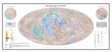
Geological map of the Moon

Maps of the world or large areas are often either 'political' or 'physical'. The most important purpose of the political map is to show territorial borders; the purpose of the physical is to show features of geography such as mountains, soil type, or land use including infrastructures such as roads, railroads, and buildings. Topographic maps show elevations and relief with contour lines or shading. Geological maps show not only the physical surface, but characteristics of the underlying rock, fault lines, and subsurface structures.

Electronic

A USGS digital raster graphic.

From the last quarter of the 20th century, the indispensable tool of the cartographer has been the computer. Much of cartography, especially at the data-gathering survey level, has been subsumed by geographic information systems (GIS). The functionality of maps has been greatly advanced by technology simplifying the superimposition of spatially located variables onto existing geographical maps. Having local information such as rainfall level, distribution of wildlife, or demographic data integrated within the map allows more efficient analysis and better decision making. In the pre-electronic age such superimposition of data led Dr. John Snow to identify the location of an outbreak of cholera. Today, it is used by agencies of humankind, as diverse as wildlife conservationists and militaries around the world.

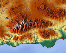
Relief map of the Sierra Nevada

Even when GIS is not involved, most cartographers now use a variety of computer graphics programs to generate new maps.

Interactive, computerized maps are commercially available, allowing users to zoom in or zoom out (respectively meaning to increase or decrease the scale), sometimes by replacing one map with another of different scale, centered where possible on the same point. In-car global navigation satellite systems are computerized maps with route planning and advice facilities that monitor the user's position with the help of satellites. From the computer scientist's point of view, zooming in entails one or a combination of:

  1. replacing the map by a more detailed one
  2. enlarging the same map without enlarging the pixels, hence showing more detail by removing less information compared to the less detailed version
  3. enlarging the same map with the pixels enlarged (replaced by rectangles of pixels); no additional detail is shown, but, depending on the quality of one's vision, possibly more detail can be seen; if a computer display does not show adjacent pixels really separate, but overlapping instead (this does not apply for an LCD, but may apply for a cathode ray tube), then replacing a pixel by a rectangle of pixels does show more detail. A variation of this method is interpolation.
A world map in PDF format.

For example:

  • Typically (2) applies to a Portable Document Format (PDF) file or other format based on vector graphics. The increase in detail is limited to the information contained in the file: enlargement of a curve may eventually result in a series of standard geometric figures such as straight lines, arcs of circles, or splines.
  • (2) may apply to text and (3) to the outline of a map feature such as a forest or building.
  • (1) may apply to the text as needed (displaying labels for more features), while (2) applies to the rest of the image. Text is not necessarily enlarged when zooming in. Similarly, a road represented by a double line may or may not become wider when one zooms in.
  • The map may also have layers that are partly raster graphics and partly vector graphics. For a single raster graphics image (2) applies until the pixels in the image file correspond to the pixels of the display, thereafter (3) applies.

Climatic

Mean Annual Temperature map of Ohio from "Geography of Ohio" 1923

The maps that reflect the territorial distribution of climatic conditions based on the results of long-term observations are called climatic maps. These maps can be compiled both for individual climatic features (temperature, precipitation, humidity) and for combinations of them at the earth's surface and in the upper layers of the atmosphere. Climatic maps show climatic features across a large region and permit values of climatic features to be compared in different parts of the region. When generating the map, spatial interpolation can be used to synthesize values where there are no measurements, under the assumption that conditions change smoothly.

Climatic maps generally apply to individual months and the year as a whole, sometimes to the four seasons, to the growing period, and so forth. On maps compiled from the observations of ground meteorological stations, atmospheric pressure is converted to sea level. Air temperature maps are compiled both from the actual values observed on the surface of the earth and from values converted to sea level. The pressure field in the free atmosphere is represented either by maps of the distribution of pressure at different standard altitudes—for example, at every kilometer above sea level—or by maps of baric topography on which altitudes (more precisely geopotentials) of the main isobaric surfaces (for example, 900, 800, and 700 millibars) counted off from sea level are plotted. The temperature, humidity, and wind on aero climatic maps may apply either to standard altitudes or to the main isobaric surfaces.

Isolines are drawn on maps of such climatic features as the long-term mean values (of atmospheric pressure, temperature, humidity, total precipitation, and so forth) to connect points with equal values of the feature in question—for example, isobars for pressure, isotherms for temperature, and isohyets for precipitation. Isoamplitudes are drawn on maps of amplitudes (for example, annual amplitudes of air temperature—that is, the differences between the mean temperatures of the warmest and coldest month). Isanomals are drawn on maps of anomalies (for example, deviations of the mean temperature of each place from the mean temperature of the entire latitudinal zone). Isolines of frequency are drawn on maps showing the frequency of a particular phenomenon (for example, the annual number of days with a thunderstorm or snow cover). Isochrones are drawn on maps showing the dates of onset of a given phenomenon (for example, the first frost and appearance or disappearance of the snow cover) or the date of a particular value of a meteorological element in the course of a year (for example, passing of the mean daily air temperature through zero). Isolines of the mean numerical value of wind velocity or isotachs are drawn on wind maps (charts); the wind resultants and directions of prevailing winds are indicated by arrows of different lengths or arrows with different plumes; lines of flow are often drawn. Maps of the zonal and meridional components of wind are frequently compiled for the free atmosphere. Atmospheric pressure and wind are usually combined on climatic maps. Wind roses, curves showing the distribution of other meteorological elements, diagrams of the annual course of elements at individual stations, and the like are also plotted on climatic maps.

Maps of climatic regionalization, that is, division of the earth's surface into climatic zones and regions according to some classification of climates, are a special kind of climatic map.

Climatic maps are often incorporated into climatic atlases of varying geographic ranges (globe, hemispheres, continents, countries, oceans) or included in comprehensive atlases. Besides general climatic maps, applied climatic maps and atlases have great practical value. Aero climatic maps, aero climatic atlases, and agro climatic maps are the most numerous.

Extraterrestrial

Maps exist of the Solar System, and other cosmological features such as star maps. In addition maps of other bodies such as the Moon and other planets are technically not geographical maps. Floor maps are also spatial but not necessarily geospatial.

Topological

In a topological map, like this one showing inventory locations, the distances between locations are not important. Only the layout and connectivity between them matters.

Diagrams such as schematic diagrams and Gantt charts and tree maps display logical relationships between items, rather than geographical relationships. Topological in nature, only the connectivity is significant. The London Underground map and similar subway maps around the world are a common example of these maps.

General

General-purpose maps provide many types of information on one map. Most atlas maps, wall maps, and road maps fall into this category. The following are some features that might be shown on general-purpose maps: bodies of water, roads, railway lines, parks, elevations, towns and cities, political boundaries, latitude and longitude, national and provincial parks. These maps give a broad understanding of the location and features of an area. The reader may gain an understanding of the type of landscape, the location of urban places, and the location of major transportation routes all at once.

Extremely large maps

The Great Polish Map of Scotland

The Great Polish Map of Scotland at Barony Castle, Scotland

Polish general Stanisław Maczek had once been shown an impressive outdoor map of land and water in the Netherlands demonstrating the working of the waterways (which had been an obstacle to the Polish forces progress in 1944). This had inspired Maczek and his companions to create Great Polish Map of Scotland as a 70-ton permanent three-dimensional reminder of Scotland's hospitality to his compatriots. In 1974, the coastline and relief of Scotland were laid out by Kazimierz Trafas, a Polish student geographer-planner, based on existing Bartholomew Half-Inch map sheets. Engineering infrastructure was put in place to surround it with a sea of water and at the General's request some of the main rivers were even arranged to flow from headwaters pumped into the mountains. The map was finished in 1979, but had to be restored between 2013 and 2017.

Challenger Relief Map of British Columbia

The Challenger Relief Map of British Columbia is a hand-built topographic map of the province, 80 feet by 76 feet. Built by George Challenger and his family from 1947 to 1954, it features all of B.C.'s mountains, lakes, rivers and valleys in exact-scaled topographical detail. Residing in the British Columbia Pavilion at the Pacific National Exhibition (PNE) in Vancouver from 1954 to 1997 it was viewed by millions of visitors. The Guinness Book of Records cites the Challenger Map as the largest of its kind in the world. The map in its entirety occupies 6,080 square feet (1,850 square metres) of space. It was disassembled in 1997; there is a project to restore it in a new location.

Relief map of Guatemala

Mapa en Relieve de Guatemala

The Relief map of Guatemala was made by Francisco Vela in 1905 and still exists. This map (horizontal scale 1:10,000; vertical scale 1:2,000) measures 1,800 m2, and was created to educate children in the scape of their country.

List

Legal regulation

Some countries required that all published maps represent their national claims regarding border disputes. For example:

  • Within Russia, Google Maps shows Crimea as part of Russia.
  • Both the Republic of India and the People's Republic of China require that all maps show areas subject to the Sino-Indian border dispute in their own favor.

In 2010, the People's Republic of China began requiring that all online maps served from within China be hosted there, making them subject to Chinese laws.

Representation of a Lie group

From Wikipedia, the free encyclopedia https://en.wikipedia.org/wiki/Representation_of_a_Lie_group...