Search This Blog

Friday, May 21, 2021

Nutrient

From Wikipedia, the free encyclopedia
https://en.wikipedia.org/wiki/Nutrient

A nutrient is a substance used by an organism to survive, grow, and reproduce. The requirement for dietary nutrient intake applies to animals, plants, fungi, and protists. Nutrients can be incorporated into cells for metabolic purposes or excreted by cells to create non-cellular structures, such as hair, scales, feathers, or exoskeletons. Some nutrients can be metabolically converted to smaller molecules in the process of releasing energy, such as for carbohydrates, lipids, proteins, and fermentation products (ethanol or vinegar), leading to end-products of water and carbon dioxide. All organisms require water. Essential nutrients for animals are the energy sources, some of the amino acids that are combined to create proteins, a subset of fatty acids, vitamins and certain minerals. Plants require more diverse minerals absorbed through roots, plus carbon dioxide and oxygen absorbed through leaves. Fungi live on dead or living organic matter and meet nutrient needs from their host.

Different types of organisms have different essential nutrients. Ascorbic acid (vitamin C) is essential, meaning it must be consumed in sufficient amounts, to humans and some other animal species, but some animals and plants are able to synthesize it. Nutrients may be organic or inorganic: organic compounds include most compounds containing carbon, while all other chemicals are inorganic. Inorganic nutrients include nutrients such as iron, selenium, and zinc, while organic nutrients include, among many others, energy-providing compounds and vitamins.

A classification used primarily to describe nutrient needs of animals divides nutrients into macronutrients and micronutrients. Consumed in relatively large amounts (grams or ounces), macronutrients (carbohydrates, fats, proteins, water) are primarily used to generate energy or to incorporate into tissues for growth and repair. Micronutrients are needed in smaller amounts (milligrams or micrograms); they have subtle biochemical and physiological roles in cellular processes, like vascular functions or nerve conduction. Inadequate amounts of essential nutrients, or diseases that interfere with absorption, result in a deficiency state that compromises growth, survival and reproduction. Consumer advisories for dietary nutrient intakes, such as the United States Dietary Reference Intake, are based on deficiency outcomes[clarification needed] and provide macronutrient and micronutrient guides for both lower and upper limits of intake. In many countries, macronutrients and micronutrients in significant content[clarification needed] are required by regulations to be displayed on food product labels. Nutrients in larger quantities than the body needs may have harmful effects. Edible plants also contain thousands of compounds generally called phytochemicals which have unknown effects on disease or health, including a diverse class with non-nutrient status called polyphenols, which remain poorly understood as of 2017.

Types

Macronutrients

Macronutrients are defined in several ways.

Macronutrients provide energy:


Biomolecule Kilocalories per 1 gram
Protein 4
Carbohydrate 4
Ethanol (drinking alcohol) 7
Fat 9

Micronutrients

Micronutrients support metabolism.

  • Dietary minerals are generally trace elements, salts, or ions such as copper and iron. Some of these minerals are essential to human metabolism.
  • Vitamins are organic compounds essential to the body. They usually act as coenzymes or cofactors for various proteins in the body.

Essentiality

Essential

An essential nutrient is a nutrient required for normal physiological function that cannot be synthesized in the body – either at all or in sufficient quantities – and thus must be obtained from a dietary source. Apart from water, which is universally required for the maintenance of homeostasis in mammals, essential nutrients are indispensable for various cellular metabolic processes and; for the maintenance and function of tissues and organs. In the case of humans, there are nine amino acids, two fatty acids, thirteen vitamins and fifteen minerals that are considered essential nutrients. In addition, there are several molecules that are considered conditionally essential nutrients since they are indispensable in certain developmental and pathological states.

Amino acids

An essential amino acid is an amino acid that is required by an organism but cannot be synthesized de novo by it, and therefore must be supplied in its diet. Out of the twenty standard protein-producing amino acids, nine cannot be endogenously synthesized by humans: phenylalanine, valine, threonine, tryptophan, methionine, leucine, isoleucine, lysine, and histidine.

Fatty acids

Essential fatty acids (EFAs) are fatty acids that humans and other animals must ingest because the body requires them for good health but cannot synthesize them. Only two fatty acids are known to be essential for humans: alpha-linolenic acid (an omega-3 fatty acid) and linoleic acid (an omega-6 fatty acid).

Vitamins

Vitamins are organic molecules essential for an organism that are not classified as amino acids or fatty acids. They commonly function as enzymatic cofactors, metabolic regulators or antioxidants. Humans require thirteen vitamins in their diet, most of which are actually groups of related molecules (e.g. vitamin E includes tocopherols and tocotrienols): vitamins A, C, D, E, K, thiamine (B1), riboflavin (B2), niacin (B3), pantothenic acid (B5), vitamin B6 (e.g., pyridoxine), biotin (B7), folate (B9), and cobalamin (B12). The requirement for vitamin D is conditional, as people who get sufficient exposure to ultraviolet light, either from the sun or an artificial source, synthesize vitamin D in the skin.

Minerals

Minerals are the exogenous chemical elements indispensable for life. Although the four elements: carbon, hydrogen, oxygen, and nitrogen, are essential for life, they are so plentiful in food and drink that these are not considered nutrients and there are no recommended intakes for these as minerals. The need for nitrogen is addressed by requirements set for protein, which is composed of nitrogen-containing amino acids. Sulfur is essential, but again does not have a recommended intake. Instead, recommended intakes are identified for the sulfur-containing amino acids methionine and cysteine.

The essential nutrient elements for humans, listed in order of Recommended Dietary Allowance (expressed as a mass), are potassium, chloride, sodium, calcium, phosphorus, magnesium, iron, zinc, manganese, copper, iodine, chromium, molybdenum, selenium and cobalt (the last as a component of vitamin B12). There are other minerals which are essential for some plants and animals, but may or may not be essential for humans, such as boron and silicon.

Choline

Choline is an essential nutrient. Healthy humans fed diets that are deficient in choline develop fatty liver, liver damage, and muscle damage. Choline was not initially classified as essential because the human body can produce choline in small amounts through phosphatidylcholine metabolism.

Conditionally essential

Conditionally essential nutrients are certain organic molecules that can normally be synthesized by an organism, but under certain conditions in insufficient quantities. In humans, such conditions include premature birth, limited nutrient intake, rapid growth, and certain disease states. Inositol, taurine, arginine, glutamine and nucleotides are classified as conditionally essential and are particularly important in neonatal diet and metabolism.

Non-essential

Non-essential nutrients are substances within foods that can have a significant impact on health. Insoluble dietary fiber is not absorbed in the human digestive tract, but is important in maintaining the bulk of a bowel movement to avoid constipation. Soluble fiber can be metabolized by bacteria residing in the large intestine. Soluble fiber is marketed as serving a prebiotic function with claims for promoting "healthy" intestinal bacteria. Bacterial metabolism of soluble fiber also produces short-chain fatty acids like butyric acid, which may be absorbed into intestinal cells as a source of food energy.

Non-nutrients

Ethanol (C2H5OH) is not an essential nutrient, but it does supply approximately 29 kilojoules (7 kilocalories) of food energy per gram. For spirits (vodka, gin, rum, etc.) a standard serving in the United States is 44 millilitres (1+12 US fluid ounces), which at 40% ethanol (80 proof) would be 14 grams and 410 kJ (98 kcal). At 50% alcohol, 17.5 g and 513 kJ (122.5 kcal). Wine and beer contain a similar amount of ethanol in servings of 150 and 350 mL (5 and 12 US fl oz), respectively, but these beverages also contribute to food energy intake from components other than ethanol. A 150 mL (5 US fl oz) serving of wine contains 420 to 540 kJ (100 to 130 kcal). A 350 mL (12 US fl oz) serving of beer contains 400 to 840 kJ (95 to 200 kcal). According to the U.S. Department of Agriculture, based on NHANES 2013–2014 surveys, women ages 20 and up consume on average 6.8 grams of alcohol per day and men consume on average 15.5 grams per day. Ignoring the non-alcohol contribution of those beverages, the average ethanol contributions to daily food energy intake are 200 and 450 kJ (48 and 108 kcal), respectively. Alcoholic beverages are considered empty calorie foods because, while providing energy, they contribute no essential nutrients.

By definition, phytochemicals include all nutritional and non-nutritional components of edible plants. Included as nutritional constituents are provitamin A carotenoids, whereas those without nutrient status are diverse polyphenols, flavonoids, resveratrol, and lignans – often claimed to have antioxidant effects – that are present in numerous plant foods. A number of phytochemical compounds are under preliminary research for their potential effects on human diseases and health. However, the qualification for nutrient status of compounds with poorly defined properties in vivo is that they must first be defined with a Dietary Reference Intake level to enable accurate food labeling, a condition not established for most phytochemicals that are claimed to be antioxidant nutrients.

Deficiencies and toxicity

An inadequate amount of a nutrient is a deficiency. Deficiencies can be due to a number of causes including an inadequacy in nutrient intake, called a dietary deficiency, or any of several conditions that interfere with the utilization of a nutrient within an organism. Some of the conditions that can interfere with nutrient utilization include problems with nutrient absorption, substances that cause a greater than normal need for a nutrient, conditions that cause nutrient destruction, and conditions that cause greater nutrient excretion. Nutrient toxicity occurs when excess consumption of a nutrient does harm to an organism.

In the United States and Canada, recommended dietary intake levels of essential nutrients are based on the minimum level that "will maintain a defined level of nutriture in an individual", a definition somewhat different from that used by the World Health Organization and Food and Agriculture Organization of a "basal requirement to indicate the level of intake needed to prevent pathologically relevant and clinically detectable signs of a dietary inadequacy".

In setting human nutrient guidelines, government organizations do not necessarily agree on amounts needed to avoid deficiency or maximum amounts to avoid the risk of toxicity. For example, for vitamin C, recommended intakes range from 40 mg/day in India to 155 mg/day for the European Union. The table below shows U.S. Estimated Average Requirements (EARs) and Recommended Dietary Allowances (RDAs) for vitamins and minerals, PRIs for the European Union (same concept as RDAs), followed by what three government organizations deem to be the safe upper intake. RDAs are set higher than EARs to cover people with higher than average needs. Adequate Intakes (AIs) are set when there is not sufficient information to establish EARs and RDAs. Countries establish tolerable upper intake levels, also referred to as upper limits (ULs), based on amounts that cause adverse effects. Governments are slow to revise information of this nature. For the U.S. values, with the exception of calcium and vitamin D, all of the data date from 1997–2004.

Plant

Plant nutrients consist of more than a dozen minerals absorbed through roots, plus carbon dioxide and oxygen absorbed or released through leaves. All organisms obtain all their nutrients from the surrounding environment.

Plants absorb carbon, hydrogen and oxygen from air and soil in the form of carbon dioxide and water. Other nutrients are absorbed from soil (exceptions include some parasitic or carnivorous plants). Counting these, there are 17 important nutrients for plants: these are macronutrients; nitrogen (N), phosphorus (P), potassium (K), calcium (Ca), sulfur (S), magnesium (Mg), carbon (C), oxygen(O) and hydrogen (H), and the micronutrients; iron (Fe), boron (B), chlorine (Cl), manganese (Mn), zinc (Zn), copper (Cu), molybdenum (Mo) and nickel (Ni). In addition to carbon, hydrogen and oxygen; nitrogen, phosphorus, and sulfur are also needed in relatively large quantities. Together, the "Big Six" are the elemental macronutrients for all organisms. They are sourced from inorganic matter (for example, carbon dioxide, water, nitrates, phosphates, sulfates, and diatomic molecules of nitrogen and, especially, oxygen) and organic matter (carbohydrates, lipids, proteins).
Geology of the Himalaya

From Wikipedia, the free encyclopedia
 
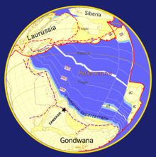
Fig 1: The Earth in the Early Permian (290 million years ago) when India was not part of Gondwana and bordered to the north by the Cimmerian Superterrane. Paleogeographic reconstruction by Dèzes (1999), based on Stampfli & Borel (2002) and Patriat & Achache (1984).
 
Fig 2: The Earth at the Permian-Triassic boundary. The opening of the Neotethys separates the Cimmeridian Superterrane from Gondwana. Based on Stampfli & Borel (2002) and Patriat & Achache (1984).
 
Fig 3: The earth in the Cretaceous. The Cimmeridian Superterrane has accreted to Mega Laurasia, the oceanic crust of the Neotethys is subducted to the north along the Dras volcanic arc, the Shigatze Ocean opens as a consequence of back-arc spreading, India is separated from Africa and E. Gondwana and the Indian Ocean opens. Paleogeographic reconstructions based by Dèzes (1999), on Stampfli & Borel (2002) and Patriat & Achache (1984).
 
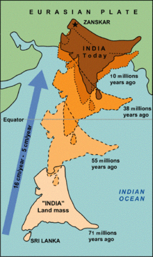
Fig 4: The northward drift of India from 71 Ma ago to present time. Note the simultaneous counter-clockwise rotation of India. Collision of the Indian continent with Eurasia occurred at about 55 million years ago. Source: www.usgs.org (modified)
 
Fig 5: Geologic - Tectonic map of the Himalaya, modified after Le Fort & Cronin (1988). Green is the Indus-Yarlung suture zone.
 
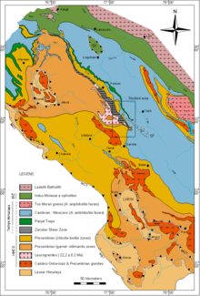
Fig 6: Geological Map of the NW Himalaya; for references, see image description or bibliography. HHCS: High Himalayan Cristalline Sequence; ISZ: Indus Suture Zone; KW: Kishtwar Window; LKRW: Larji-Kulu-Rampur Window; MBT: Main Boundary Thrust; MCT: Main Central Thrust; SF: Sarchu Fault; ZSZ: Zanskar Shear Zone. 
 
Fig 7: Simplified cross-section of the north-western Himalaya showing the main tectonic units and structural elements by Dèzes (1999).
 
Fig 8: Indus-Yarlung suture zone separates Himalayas from the Transhimalayas. Lhasa Terrane (also called Karakoram-Lhasa Block/Terrane) lies within the Transhimalayas in its east side. Bangong-Nujiang Suture Zone separates Qiangtang Terrane from the Lahsa Terrane

The geology of the Himalayas is a record of the most dramatic and visible creations of the immense mountain range formed by plate tectonic forces and sculpted by weathering and erosion. The Himalayas, which stretch over 2400 km between the Namcha Barwa syntaxis in Tibet and the Nanga Parbat syntaxis in Kashmir, are the result of an ongoing orogeny — the collision of the continental crust of two tectonic plates namely the Indian Plate thrusting into the Eurasian Plate. The Himalaya-Tibet region supplies fresh water for more than one-fifth of the world population, and accounts for a quarter of the global sedimentary budget. Topographically, the belt has many superlatives: the highest rate of uplift (nearly 10 mm/year at Nanga Parbat), the highest relief (8848 m at Mt. Everest Chomolangma), among the highest erosion rates at 2–12 mm/yr, the source of some of the greatest rivers and the highest concentration of glaciers outside of the polar regions. This last feature earned the Himalaya its name, originating from the Sanskrit for "the abode of the snow".

From south to north the Himalaya (Himalaya orogen) is divided into 4 parallel tectonostratigraphic zones and 5 thrust faults which extend across the length of Himalaya orogen. Each zone, flanked by the thrust faults on its north and south, has stratigraphy (type of rocks and their layering) different from the adjacent zones. From south to north, the zones and the major faults separating them are the Main Frontal Thrust (MFT), Subhimalaya Zone (also called Sivalik), Main Boundary Thrust (MBT), Lesser Himalaya (further subdivided into the "Lesser Himalayan Sedimentary Zone (LHSZ) and the Lesser Himalayan Crystalline Nappes (LHCN)), Main Central thrust (MCT), Higher (or Greater) Himalayan crystallines (HHC), South Tibetan detachment system (STD), Tethys Himalaya (TH), and the Indus‐Tsangpo Suture Zone (ISZ). North of this lies the transhimalaya in Tibet which is outside the Himalayas. Himalaya has Indo-Gangetic Plain in south, Pamir Mountains in west in Central Asia, and Hengduan Mountains in east on China–Myanmar border.

From east to west the Himalayas are divided into 3 regions, Eastern Himalaya, Central Himalaya, and Western Himalaya, which collectively house several nations and states.

Making of the Himalayas

During Late Precambrian and the Palaeozoic, the Indian Subcontinent, bounded to the north by the Cimmerian Superterranes, was part of Gondwana and was separated from Eurasia by the Paleo-Tethys Ocean (Fig. 1). During that period, the northern part of India was affected by a late phase of the Pan-African orogeny which is marked by an unconformity between Ordovician continental conglomerates and the underlying Cambrian marine sediments. Numerous granitic intrusions dated at around 500 Ma are also attributed to this event.

In the Early Carboniferous, an early stage of rifting developed between the Indian subcontinent and the Cimmerian Superterranes. During the Early Permian, this rift developed into the Neotethys ocean (Fig. 2). From that time on, the Cimmerian Superterranes drifted away from Gondwana towards the north. Nowadays, Iran, Afghanistan and Tibet are partly made up of these terranes.

In the Norian (210 Ma), a major rifting episode split Gondwana in two parts. The Indian continent became part of East Gondwana, together with Australia and Antarctica. However, the separation of East and West Gondwana, together with the formation of oceanic crust, occurred later, in the Callovian (160-155 Ma). The Indian plate then broke off from Australia and Antarctica in the Early Cretaceous (130-125 Ma) with the opening of the "South Indian Ocean" (Fig. 3).

In the Late Cretaceous (84 Ma), the Indian plate began its very rapid northward drift covering a distance of about 6000 km, with the oceanic-oceanic subduction continuing until the final closure of the oceanic basin and the obduction of oceanic ophiolite onto India and the beginning of continent-continent tectonic interaction starting at about 65 Ma in the Central Himalaya. The change of the relative speed between the Indian and Asian plates from very fast (18-19.5 cm/yr) to fast (4.5 cm/yr) at about 55 Ma is circumstantial support for collision then. Since then there has been about 2500 km of crustal shortening and rotating of India by 45° counterclockwise in the Northwestern Himalaya to 10°-15° counterclockwise in North Central Nepal relative to Asia (Fig. 4).

While most of the oceanic crust was "simply" subducted below the Tibetan block during the northward motion of India, at least three major mechanisms have been put forward, either separately or jointly, to explain what happened, since collision, to the 2500 km of "missing continental crust".

Even though it is more than reasonable to argue that this huge amount of crustal shortening most probably results from a combination of these three mechanisms, it is nevertheless the last mechanism which created the high topographic relief of the Himalaya.

The ongoing active collision of the Indian and Eurasian continental plates challenges one hypothesis for plate motion which relies on subduction.

Major tectonic subdivisions of the Himalaya

One of the most striking aspects of the Himalayan orogen is the lateral continuity of its major tectonic elements. The Himalaya is classically divided into four tectonic units that can be followed for more than 2400 km along the belt (Fig. 5 and Fig. 7).

Sub-Himalayan (Churia Hills or Sivaliks) tectonic plate

The Sub-Himalayan tectonic plate is sometimes referred to as the Cis-Himalayan tectonic plate in the older literature. It forms the southern foothills of the Himalayan Range and is essentially composed of Miocene to Pleistocene molassic sediments derived from the erosion of the Himalaya. These molasse deposits, known as the "Murree and Sivaliks Formations", are internally folded and imbricated. The Sub-Himalayan Range is thrust along the Main Frontal Thrust over the Quaternary alluvium deposited by the rivers coming from the Himalaya (Ganges, Indus, Brahmaputra and others), which demonstrates that the Himalaya is still a very active orogen.

Lesser Himalaya (LH) tectonic plate

The Lesser Himalaya (LH) tectonic plate is mainly formed by Upper Proterozoic to lower Cambrian detrital sediments from the passive Indian margin intercalated with some granites and acid volcanics (1840 ±70 Ma). These sediments are thrust over the Sub-himalayan range along the Main Boundary Thrust (MBT). The Lesser Himalaya often appears in tectonic windows (Kishtwar or Larji-Kulu-Rampur windows) within the High Himalaya Crystalline Sequence.

Central Himalayan Domain, (CHD) or High Himalaya tectonic plate

The Central Himalayan Domain forms the backbone of the Himalayan orogen and encompasses the areas with the highest topographic relief (highest peaks). It is commonly separated into four zones.

High Himalayan Crystalline Sequence (HHCS)

Approximately 30 different names exist in the literature to describe this unit; the most frequently found equivalents are "Greater Himalayan Sequence", "Tibetan Slab" and "High Himalayan Crystalline". It is a 30-km-thick, medium- to high-grade metamorphic sequence of metasedimentary rocks which are intruded in many places by granites of Ordovician (c. 500 Ma) and early Miocene (c. 22 Ma) age. Although most of the metasediments forming the HHCS are of late Proterozoic to early Cambrian age, much younger metasediments can also be found in several areas, e.g. Mesozoic in the Tandi syncline of Nepal and Warwan Valley of Kistwar in Kashmir, Permian in the "Tschuldo slice", Ordovician to Carboniferous in the "Sarchu area" on Leh-Manali Highway. It is now generally accepted that the metasediments of the HHCS represent the metamorphic equivalents of the sedimentary series forming the base of the overlying "Tethys Himalaya". The HHCS forms a major nappe which is thrust over the Lesser Himalaya along the "Main Central Thrust" (MCT).

Tethys Himalaya (TH)

The Tethys Himalaya is an approximately 100-km-wide synclinorium formed by strongly folded and imbricated, weakly metamorphosed sedimentary series. Several nappes, termed the "North Himalayan Nappes", have also been described within this unit. An almost complete stratigraphic record ranging from the Upper Proterozoic to the Eocene is preserved within the sediments of the TH. Stratigraphic analysis of these sediments yields important indications on the geological history of the northern continental margin of the Indian sub-continent from its Gondwanian evolution to its continental collision with Eurasia. The transition between the generally low-grade sediments of the "Tethys Himalaya" and the underlying low- to high-grade rocks of the "High Himalayan Crystalline Sequence" is usually progressive. But in many places along the Himalayan belt, this transition zone is marked by a major structure, the "Central Himalayan Detachment System", also known as the "South Tibetan Detachment System" or "North Himalayan Normal Fault", which has indicators of both extension and compression. See ongoing geologic studies section below.

Nyimaling-Tso Morari Metamorphic Dome (NTMD)

'"Nyimaling-Tso Morari Metamorphic Dome" in the Ladakh region, the "Tethys Himalaya synclinorium" passes gradually to the north in a large dome of greenschist to eclogitic metamorphic rocks. As with the HHCS, these metamorphic rocks represent the metamorphic equivalent of the sediments forming the base of the Tethys Himalaya. The "Precambrian Phe Formation" is also here intruded by several Ordovician (c. 480 Ma) granites.

Lamayuru and Markha Units (LMU)

The Lamayuru and Markha Units are formed by flyschs and olistholiths deposited in a turbiditic environment, on the northern part of the Indian continental slope and in the adjoining Neotethys basin. The age of these sediments ranges from Late Permian to Eocene.

Indus Suture Zone (ISZ) (or Yarlung-Tsangpo Suture Zone) tectonic plate

ISZ, also spelled "Indus-Yarlung suture zone", "Yarlung-Zangpo Suture Zone" or "Yarlung-Tsangpo Suture Zone", defines the zone of collision between the Indian Plate and the Ladakh Batholith (also Transhimalaya or Karakoram-Lhasa Block) to the north. This suture zone is formed by:


Tibetan Plateau

From Wikipedia, the free encyclopedia
 
Tibetan Plateau
青藏高原 (Qīng–Zàng Gāoyuán, Qinghai–Tibet Plateau)
Himalaya composite.jpg
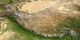
The Tibetan Plateau lies between the Himalayan range to the south and the Taklamakan Desert to the north. (Composite image)
Dimensions
Length2,500 km (1,600 mi)
Width1,000 km (620 mi)
Area2,500,000 km2 (970,000 sq mi)
Geography
Tibet and surrounding areas topographic map.png
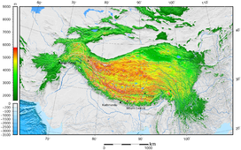
Tibetan Plateau and surrounding areas above 1600 m
LocationChina (Tibet, Qinghai, Western Sichuan, Northern Yunnan, Southern Xinjiang, Western Gansu)
India (Ladakh, Lahaul & Spiti), Pakistan (Gilgit Baltistan)
Nepal (Northern Nepal)
Bhutan
Tajikistan (Eastern Tajikistan)
Kyrgyzstan (Southern Kyrgyzstan)
Range coordinates33°N 88°ECoordinates: 33°N 88°E

The Tibetan Plateau (Tibetan: བོད་ས་མཐོ།, Wylie: bod sa mtho), also known as the Qinghai–Tibet Plateau or the Qing–Zang Plateau (Chinese: 青藏高原; pinyin: Qīng–Zàng Gāoyuán) or as the Himalayan Plateau in India, is a vast elevated plateau in South Asia, Central Asia and East Asia, covering most of the Tibet Autonomous Region, most of Qinghai, Northwestern Yunnan, Western half of Sichuan, Southern Gansu provinces in Western China, the Indian regions of Ladakh and Lahaul and Spiti (Himachal Pradesh) as well as Bhutan. It stretches approximately 1,000 kilometres (620 mi) north to south and 2,500 kilometres (1,600 mi) east to west. It is the world's highest and largest plateau above sea level, with an area of 2,500,000 square kilometres (970,000 sq mi) (about five times the size of Metropolitan France). With an average elevation exceeding 4,500 metres (14,800 ft) and being surrounded by imposing mountain ranges that harbor the world's two highest summits, Mount Everest and K2, the Tibetan Plateau is often referred to as "the Roof of the World".

The Tibetan Plateau contains the headwaters of the drainage basins of most of the streams in surrounding regions. Its tens of thousands of glaciers and other geographical and ecological features serve as a "water tower" storing water and maintaining flow. It is sometimes termed the Third Pole because its ice fields contain the largest reserve of fresh water outside the polar regions. The impact of global warming on the Tibetan Plateau is of intense scientific interest.

Description

The Tibetan Plateau is surrounded by the massive mountain ranges of high-mountain Asia. The plateau is bordered to the south by the inner Himalayan range, to the north by the Kunlun Mountains, which separate it from the Tarim Basin, and to the northeast by the Qilian Mountains, which separate the plateau from the Hexi Corridor and Gobi Desert. To the east and southeast the plateau gives way to the forested gorge and ridge geography of the mountainous headwaters of the Salween, Mekong, and Yangtze rivers in northwest Yunnan and western Sichuan (the Hengduan Mountains). In the west the curve of the rugged Karakoram range of northern Kashmir embraces the plateau. The Indus River originates in the western Tibetan Plateau in the vicinity of Lake Manasarovar.

Tibetan Buddhist stupa and houses outside the town of Ngawa, on the Tibetan Plateau.

The Tibetan Plateau is bounded in the north by a broad escarpment where the altitude drops from around 5,000 metres (16,000 ft) to 1,500 metres (4,900 ft) over a horizontal distance of less than 150 kilometres (93 mi). Along the escarpment is a range of mountains. In the west, the Kunlun Mountains separate the plateau from the Tarim Basin. About halfway across the Tarim the bounding range becomes the Altyn-Tagh and the Kunluns, by convention, continue somewhat to the south. In the 'V' formed by this split is the western part of the Qaidam Basin. The Altyn-Tagh ends near the Dangjin pass on the DunhuangGolmud road. To the west are short ranges called the Danghe, Yema, Shule, and Tulai Nanshans. The easternmost range is the Qilian Mountains. The line of mountains continues east of the plateau as the Qinling, which separates the Ordos Plateau from Sichuan. North of the mountains runs the Gansu or Hexi Corridor which was the main silk-road route from China proper to the West.

The plateau is a high-altitude arid steppe interspersed with mountain ranges and large brackish lakes. Annual precipitation ranges from 100 to 300 millimetres (3.9 to 11.8 in) and falls mainly as hail. The southern and eastern edges of the steppe have grasslands that can sustainably support populations of nomadic herdsmen, although frost occurs for six months of the year. Permafrost occurs over extensive parts of the plateau. Proceeding to the north and northwest, the plateau becomes progressively higher, colder, and drier, until reaching the remote Changtang region in the northwestern part of the plateau. Here the average altitude exceeds 5,000 metres (16,000 ft) and winter temperatures can drop to −40 °C (−40 °F). As a result of this extremely inhospitable environment, the Changthang region (together with the adjoining Kekexili region) is the least populous region in Asia and the third least populous area in the world after Antarctica and northern Greenland.

NASA satellite image of the south-eastern area of Tibetan Plateau. Brahmaputra River is in the lower right.

Geology and geological history

Yamdrok Lake is one of the three largest sacred lakes in Tibet.

The geological history of the Tibetan Plateau is closely related to that of the Himalayas. The Himalayas belong to the Alpine Orogeny and are therefore among the younger mountain ranges on the planet, consisting mostly of uplifted sedimentary and metamorphic rock. Their formation is a result of a continental collision or orogeny along the convergent boundary between the Indo-Australian Plate and the Eurasian Plate.

The collision began in the Upper Cretaceous period about 70 million years ago, when the north-moving Indo-Australian Plate, moving at about 15 cm (6 in) per year, collided with the Eurasian Plate. About 50 million years ago, this fast-moving Indo-Australian plate had completely closed the Tethys Ocean, the existence of which has been determined by sedimentary rocks settled on the ocean floor, and the volcanoes that fringed its edges. Since these sediments were light, they crumpled into mountain ranges rather than sinking to the floor. The Indo-Australian plate continues to be driven horizontally below the Tibetan Plateau, which forces the plateau to move upwards; the plateau is still rising at a rate of approximately 5 mm (0.2 in) per year.

Much of the Tibetan Plateau is of relatively low relief. The cause of this is debated among geologists. Some argue that the Tibetan Plateau is an uplifted peneplain formed at low altitude, while others argue that the low relief stems from erosion and infill of topographic depressions that occurred at already high elevations.

Environment

Typical landscape

The Tibetan Plateau supports a variety of ecosystems, most of them classified as montane grasslands. While parts of the plateau feature an alpine tundra-like environment, other areas feature monsoon-influenced shrublands and forests. Species diversity is generally reduced on the plateau due to the elevation and low precipitation. The Tibetan Plateau hosts the Tibetan wolf, and species of snow leopard, wild yak, wild donkey, cranes, vultures, hawks, geese, snakes, and water buffalo. One notable animal is the high-altitude jumping spider, that can live at elevations of over 6,500 metres (21,300 ft).

Ecoregions found on the Tibetan Plateau, as defined by the World Wide Fund for Nature, are as follows:

Human history

Pastoral nomads camping near Namtso.
Nomad camp near Tingri, Tibet. 1993

Nomads on the Tibetan Plateau and in the Himalayas are the remainders of nomadic practices historically once widespread in Asia and Africa. Pastoral nomads constitute about 40% of the ethnic Tibetan population. The presence of nomadic peoples on the plateau is predicated on their adaptation to survival on the world's grassland by raising livestock rather than crops, which are unsuitable to the terrain. Archaeological evidence suggests that the earliest human occupation of the plateau occurred between 30,000 and 40,000 years ago. Since colonization of the Tibetan Plateau, Tibetan culture has adapted and flourished in the western, southern, and eastern regions of the plateau. The northern portion, the Changtang, is generally too high and cold to support permanent population. One of the most notable civilizations to have developed on the Tibetan Plateau is the Tibetan Empire from the 7th century to the 9th century AD.

Impact on other regions

Role in monsoons

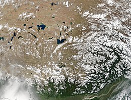
Natural-colour satellite image of the Tibetan Plateau

Monsoons are caused by the different amplitudes of surface temperature seasonal cycles between land and oceans. This differential warming occurs because heating rates differ between land and water. Ocean heating is distributed vertically through a "mixed layer" that may be 50 meters deep through the action of wind and buoyancy-generated turbulence, whereas the land surface conducts heat slowly, with the seasonal signal penetrating only a meter or so. Additionally, the specific heat capacity of liquid water is significantly greater than that of most materials that make up land. Together, these factors mean that the heat capacity of the layer participating in the seasonal cycle is much larger over the oceans than over land, with the consequence that the land warms and cools faster than the ocean. In turn, air over the land warms faster and reaches a higher temperature than does air over the ocean. The warmer air over land tends to rise, creating an area of low pressure. The pressure anomaly then causes a steady wind to blow toward the land, which brings the moist air over the ocean surface with it. Rainfall is then increased by the presence of the moist ocean air. The rainfall is stimulated by a variety of mechanisms, such as low-level air being lifted upwards by mountains, surface heating, convergence at the surface, divergence aloft, or from storm-produced outflows near the surface. When such lifting occurs, the air cools due to expansion in lower pressure, which in turn produces condensation and precipitation.

In winter, the land cools off quickly, but the ocean maintains the heat longer. The hot air over the ocean rises, creating a low-pressure area and a breeze from land to ocean while a large area of drying high pressure is formed over the land, increased by wintertime cooling. Monsoons are similar to sea and land breezes, a term usually referring to the localized, diurnal cycle of circulation near coastlines everywhere, but they are much larger in scale, stronger and seasonal. The seasonal monsoon wind shift and weather associated with the heating and cooling of the Tibetan plateau is the strongest such monsoon on Earth.

Glaciology: the Ice Age and at present

The Himalayas as seen from space looking south from over the Tibetan Plateau.

Today, Tibet is an important heating surface of the atmosphere. However, during the Last Glacial Maximum, an approximately 2,400,000 square kilometres (930,000 sq mi) ice sheet covered the plateau. Due to its great extent, this glaciation in the subtropics was an important element of radiative forcing. With a much lower latitude, the ice in Tibet reflected at least four times more radiation energy per unit area into space than ice at higher latitudes. Thus, while the modern plateau heats the overlying atmosphere, during the Last Ice Age it helped to cool it.

This cooling had multiple effects on regional climate. Without the thermal low pressure caused by the heating, there was no monsoon over the Indian subcontinent. This lack of monsoon caused extensive rainfall over the Sahara, expansion of the Thar Desert, more dust deposited into the Arabian Sea, and a lowering of the biotic life zones on the Indian subcontinent. Animals responded to this shift in climate, with the Javan rusa migrating into India.

In addition, the glaciers in Tibet created meltwater lakes in the Qaidam Basin, the Tarim Basin, and the Gobi Desert, despite the strong evaporation caused by the low latitude. Silt and clay from the glaciers accumulated in these lakes; when the lakes dried at the end of the ice age, the silt and clay were blown by the downslope wind off the Plateau. These airborne fine grains produced the enormous amount of loess in the Chinese lowlands.

Effects of climate change

The Tibetan Plateau contains the world's third-largest store of ice. Qin Dahe, the former head of the China Meteorological Administration, issued the following assessment in 2009:

Temperatures are rising four times faster than elsewhere in China, and the Tibetan glaciers are retreating at a higher speed than in any other part of the world. ... In the short term, this will cause lakes to expand and bring floods and mudflows. ... In the long run, the glaciers are vital lifelines for Asian rivers, including the Indus and the Ganges. Once they vanish, water supplies in those regions will be in peril.


Lie point symmetry

From Wikipedia, the free encyclopedia https://en.wikipedia.org/wiki/Lie_point_symmetry     ...