Search This Blog

Monday, August 8, 2022

Climate change in the Arctic

From Wikipedia, the free encyclopedia
 
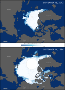
The maps above compare the Arctic ice minimum extents from 2012 (top) and 1984 (bottom).

Major environmental issues caused by contemporary climate change in the Arctic region range from the well-known, such as the loss of sea ice or melting of the Greenland ice sheet, to more obscure, but deeply significant issues, such as permafrost thaw, social consequences for locals and the geopolitical ramifications of these changes. The Arctic is likely to be especially affected by climate change because of the high projected rate of regional warming and associated impacts. Temperature projections for the Arctic region were assessed in 2007: These suggested already averaged warming of about 2 °C to 9 °C by the year 2100. The range reflects different projections made by different climate models, run with different forcing scenarios. Radiative forcing is a measure of the effect of natural and human activities on the climate. Different forcing scenarios reflect, for example, different projections of future human greenhouse gas emissions.

These effects are wide-ranging and can be seen in many Arctic systems, from fauna and flora to territorial claims. Temperatures in the region are rising twice as fast as elsewhere on Earth, leading to these effects worsening year on year and causing significant concern. The changing Arctic has global repercussions, perhaps via ocean circulation changes or arctic amplification.

Impacts on the natural environment

Temperature and weather changes

The image above shows where average air temperatures (October 2010 – September 2011) were up to 2 degrees Celsius above (red) or below (blue) the long-term average (1981–2010).

According to the Intergovernmental Panel on Climate Change, "surface air temperatures (SATs) in the Arctic have warmed at approximately twice the global rate". The period of 1995–2005 was the warmest decade in the Arctic since at least the 17th century, with temperatures 2 °C (3.6 °F) above the 1951–1990 average. In addition, since 2013, Arctic annual mean SAT has been at least 1 °C (1.8 °F) warmer than the 1981-2010 mean. With 2020 having the second warmest SAT anomaly after 2016, being 1.9 °C (3.4 °F) warmer than the 1981-2010 average.

Some regions within the Arctic have warmed even more rapidly, with Alaska and western Canada's temperature rising by 3 to 4 °C (5.40 to 7.20 °F). This warming has been caused not only by the rise in greenhouse gas concentration, but also the deposition of soot on Arctic ice. The smoke from wildfires defined as "brown carbon" also increases arctic warming. Its warming effect is around 30% from the effect of black carbon (soot). As wildfires increses with warming this create a positive feedback loop.  A 2013 article published in Geophysical Research Letters has shown that temperatures in the region haven't been as high as they currently are since at least 44,000 years ago and perhaps as long as 120,000 years ago. The authors conclude that "anthropogenic increases in greenhouse gases have led to unprecedented regional warmth."

On 20 June 2020, for the first time, a temperature measurement was made inside the Arctic Circle of 38 °C, more than 100 °F. This kind of weather was expected in the region only by 2100. In March, April and May the average temperature in the Arctic was 10 °C higher than normal. This heat wave, without human - induced warming, could happen only one time in 80,000 years, according to an attribution study published in July 2020. It is the strongest link of a weather event to anthropogenic climate change that had been ever found, for now. Such heat waves are generally a result of an unusual state of the jet stream.

Some scientists suggest that climate change will slow the jet stream by reducing the difference in temperature between the Arctic and more southern territories, because the Arctic is warming faster. This can facilitate the occurring of such heat waves. The scientists do not know if the 2020 heat wave is the result of such change.

A rise of 1.5 degrees in global temperature from the pre-industrial level will probably change the type of precipitation in the Arctic from snow to rain in summer and autumn, which will increase glaciers melting and permafrost thawing. Both effects lead to more warming.

One of the effects of climate change is a strong increase in the number of lightnings in the Arctic. Lightnings increase the risk for wildfires.

Arctic amplification

The poles of the Earth are more sensitive to any change in the planet's climate than the rest of the planet. In the face of ongoing global warming, the poles are warming faster than lower latitudes. The Arctic is warming more than twice as fast as the global average, process known as Arctic amplification (AA). The primary cause of this phenomenon is ice–albedo feedback where, by melting, ice uncovers darker land or ocean beneath, which then absorbs more sunlight, causing more heating. A study from 2019 identified sea-ice loss under increasing CO2 as a main driver for large AA. Thus, large AA only occurs from October to April in areas suffering from important sea-ice loss, because of the "Increased outgoing longwave radiation and heat fluxes from the newly opened waters".

Arctic amplification has been argued to have significant effects on midlatitude weather, contributing to more persistent hot-dry extremes and winter continental cooling.

Black carbon

Black carbon deposits (from the combustion of heavy fuel oil (HFO) of Arctic shipping) absorb solar radiation in the atmosphere and strongly reduce the albedo when deposited on snow and ice, thus accelerating the effect of the melting of snow and sea ice. A 2013 study quantified that gas flaring at petroleum extraction sites contributed over 40% of the black carbon deposited in the Arctic. Recent studies attributed the majority (56%) of Arctic surface black carbon to emissions from Russia, followed by European emissions, and Asia also being a large source.

According to a 2015 study, reductions in black carbon emissions and other minor greenhouse gases, by roughly 60 percent, could cool the Arctic up to 0.2 °C by 2050. However, a 2019 study indicates that "Black carbon emissions will continuously rise due to increased shipping activities", specifically fishing vessels.

Decline of sea ice

1870–2009 Northern Hemisphere sea ice extent in million square kilometers. Blue shading indicates the pre-satellite era; data then is less reliable.

Arctic sea ice decline has occurred in recent decades and is an effect of climate change; sea ice in the Arctic Ocean has melted more than it refreezes in the winter. Global warming, caused by greenhouse gas forcing is responsible for the decline in Arctic sea ice. Implications of arctic sea ice decline may include: Ice-free summer, amplified arctic warming, polar vortex disruption, atmospheric chemistry changes, atmospheric regime changes, changes to plant, animal, and microbial life; changed shipping options and other impacts on humans.

Sea ice in the arctic is currently in decline in area, extent, and volume, and has been accelerating during the early twenty‐first century, with a decline rate of −4.7% per decade (it has declined over 50% since the first satellite records). It is also thought that summertime sea ice will cease to exist sometime during the 21st century. This sea ice loss is one of the main drivers of surface-based Arctic amplification. Sea ice area means the total area covered by ice, whereas sea ice extent is the area of ocean with at least 15% sea ice, while the volume is the total amount of ice in the Arctic.

Changes in extent and area

Reliable measurement of sea ice edges began with the satellite era in the late 1970s. Before this time, sea ice area and extent were monitored less precisely by a combination of ships, buoys and aircraft. The data show a long-term negative trend in recent years, attributed to global warming, although there is also a considerable amount of variation from year to year. Some of this variation may be related to effects such as the Arctic oscillation, which may itself be related to global warming.

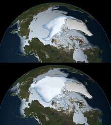
Sea ice coverage in 1980 (bottom) and 2012 (top), as observed by passive microwave sensors from NASA. Multi-year ice is shown in bright white, while average sea ice cover is shown in light blue to milky white.

The rate of the decline in entire Arctic ice coverage is accelerating. From 1979 to 1996, the average per decade decline in entire ice coverage was a 2.2% decline in ice extent and a 3% decline in ice area. For the decade ending 2008, these values have risen to 10.1% and 10.7%, respectively. These are comparable to the September to September loss rates in year-round ice (i.e., perennial ice, which survives throughout the year), which averaged a retreat of 10.2% and 11.4% per decade, respectively, for the period 1979–2007.

The Arctic sea ice September minimum extent (SIE) (i.e., area with at least 15% sea ice coverage) reached new record lows in 2002, 2005, 2007, 2012 (5.32 million km2), 2016 and 2019 (5.65 million km2). The 2007 melt season let to a minimum 39% below the 1979–2000 average, and for the first time in human memory, the fabled Northwest Passage opened completely. During July 2019 the warmest month in the Arctic was recorded, reaching the lowest SIE (7.5 million km2) and sea ice volume (8900 km3). Setting a decadal trend of SIE decline of -13%. As for now, the SIE has shrink by 50% since the 1970s.

From 2008 to 2011, Arctic sea ice minimum extent was higher than 2007, but it did not return to the levels of previous years. In 2012 however, the 2007 record low was broken in late August with three weeks still left in the melt season. It continued to fall, bottoming out on 16 September 2012 at 3.42 million square kilometers (1.32 million square miles), or 760,000 square kilometers (293,000 square miles) below the previous low set on 18 September 2007 and 50% below the 1979–2000 average.

Changes in volume

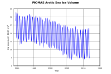
Seasonal variation and long-term decrease of Arctic sea ice volume as determined by measurement backed numerical modelling.

The sea ice thickness field and accordingly the ice volume and mass, is much more difficult to determine than the extension. Exact measurements can be made only at a limited number of points. Because of large variations in ice and snow thickness and consistency air- and spaceborne-measurements have to be evaluated carefully. Nevertheless, the studies made support the assumption of a dramatic decline in ice age and thickness. While the Arctic ice area and extent show an accelerating downward trend, arctic ice volume shows an even sharper decline than the ice coverage. Since 1979, the ice volume has shrunk by 80% and in just the past decade the volume declined by 36% in the autumn and 9% in the winter. And currently, 70% of the winter sea ice has turned into seasonal ice.

An end to summer sea ice?

The IPCC's Fourth Assessment Report in 2007 summarized the current state of sea ice projections: "the projected reduction [in global sea ice cover] is accelerated in the Arctic, where some models project summer sea ice cover to disappear entirely in the high-emission A2 scenario in the latter part of the 21st century.″  However, current climate models frequently underestimate the rate of sea ice retreat. A summertime ice-free Arctic would be unprecedented in recent geologic history, as currently scientific evidence does not indicate an ice-free polar sea anytime in the last 700,000 years.

The Arctic ocean will likely be free of summer sea ice before the year 2100, but many different dates have been projected, with models showing near-complete to complete loss in September from 2035 to some time around 2067.

Melting of the Greenland ice sheet

Albedo Change on Greenland

Models predict a sea-level contribution of about 5 centimetres (2 in) from melting of the Greenland ice sheet during the 21st century. It is also predicted that Greenland will become warm enough by 2100 to begin an almost complete melt during the next 1,000 years or more. In early July 2012, 97% percent of the ice sheet experienced some form of surface melt, including the summits.

Ice thickness measurements from the GRACE satellite indicate that ice mass loss is accelerating. For the period 2002–2009, the rate of loss increased from 137 Gt/yr to 286 Gt/yr, with every year seeing on average 30 gigatonnes more mass lost than in the preceding year. The rate of melting was 4 times higher in 2019 than in 2003. In the year 2019 the melting contributed 2.2 millimeters to sea level rise in just 2 months. Overall, the signs are overwhelming that melting is not only occurring, but accelerating year on year.

Greenland ice sheet mass trend (2003–2005)

According to a study published in "Nature Communications Earth and Environment" the Greenland ice sheet is possibly past the point of no return, meaning that even if the rise in temperature were to completely stop and even if the climate were to become a little colder, the melting would continue. This outcome is due to the movement of ice from the middle of Greenland to the coast, creating more contact between the ice and warmer coastal water and leading to more melting and calving. Another climate scientist says that after all the ice near the coast melts, the contact between the seawater and the ice will stop what can prevent further warming.

In September 2020, satellite imagery showed that a big chunk of ice shattered into many small pieces from the last remaining ice shelf in Nioghalvfjerdsfjorden, Greenland. This ice sheet is connected to the interior ice sheet, and could prove a hotspot for deglaciation in coming years.

Another unexpected effect of this melting relates to activities by the United States military in the area. Specifically, Camp Century, a nuclear powered base which has been producing nuclear waste over the years. In 2016, a group of scientists evaluated the environmental impact and estimated that due to changing weather patterns over the next few decades, melt water could release the nuclear waste, 20,000 liters of chemical waste and 24 million liters of untreated sewage into the environment. However, so far neither US or Denmark has taken responsibility for the clean-up.

Changes in vegetation

Western Hemisphere Arctic Vegetation Index Trend
 
Eastern Hemisphere Vegetation Index Trend

Climate change is expected to have a strong effect on the Arctic's flora, some of which is already being seen. These changes in vegetation are associated with the increases in landscape scale methane emissions, as well as increases in CO2, TÂș and the disruption of ecological cycles which affect patterns in nutrient cycling, humidity and other key ecological factors that help shape plant communities.

A large source of information for how vegetation has adapted to climate change over the last years comes from satellite records, which help quantify shifts in vegetation in the Arctic region. For decades, NASA and NOAA satellites have continuously monitored vegetation from space. The Moderate Resolution Imaging Spectroradiometer (MODIS) and Advanced Very High-Resolution Radiometer (AVHRR) instruments, as well as others, measure the intensity of visible and near-infrared light reflecting off of plant leaves. Scientists use this information to calculate the Normalized Difference Vegetation Index (NDVI), an indicator of photosynthetic activity or “greenness” of the landscape, which is most often used. There also exist other indices, such as the Enhanced Vegetation Index (EVI) or Soil-Adjusted Vegetation Index (SAVI).

These indices can be used as proxies for vegetation productivity, and their shifts over time can provide information on how vegetation changes over time. One of the two most used ways to define shifts in vegetation in the Arctic are the concepts of Arctic greening and Arctic browning. The former refers to a positive trend in the aforementioned greenness indices, indicating increases in plant cover or biomass whereas browning can be broadly understood as a negative trend, with decreases in those variables.

Recent studies have allowed us to get an idea of how these two processes have progressed in recent years. It has been found that from 1985 to 2016, greening has occurred in 37.3% of all sites sampled in the tundra, whereas browning was observed only in 4.7% of them. Certain variables influenced this distribution, as greening was mostly associated with sites with higher summer air temperature, soil temperature and soil moisture. On the other hand, browning was found to be linked with colder sites that were experiencing cooling and drying. Overall, this paints the picture of widespread greening occurring throughout significant portions of the arctic tundra, as a consequence of increases in plant productivity, height, biomass and shrub dominance in the area.

This expansion of vegetation in the Arctic is not equivalent across types of vegetation. One of the most dramatic changes arctic tundras are currently facing is the expansion of shrubs, which, thanks to increases in air temperature and, to a lesser extent, precipitation have contributed to an Arctic-wide trend known as "shrubification", where shrub type plants are taking over areas previously dominated by moss and lichens. This change contributes to the consideration that the tundra biome is currently experiencing the most rapid change of any terrestrial biomes on the planet.

The direct impact on mosses and lichens is unclear as there exist very few studies at species level, but climate change is more likely to cause increased fluctuation and more frequent extreme events. The expansion of shrubs could affect permafrost dynamics, but the picture is quite unclear at the moment. In the winter, shrubs trap more snow, which insulates the permafrost from extreme cold spells, but in the summer they shade the ground from direct sunlight, how these two effects counter and balance each other is not yet well understood. Warming is likely to cause changes in plant communities overall, contributing to the rapid changes tundra ecosystems are facing. While shrubs may increase in range and biomass, warming may also cause a decline in cushion plants such as moss campion, and since cushion plants act as facilitator species across trophic levels and fill important ecological niches in several environments, this could cause cascading effects in these ecosystems that could severely affect the way in which they function and are structured.

The expansion of these shrubs can also have strong effects on other important ecological dynamics, such as the albedo effect. These shrubs change the winter surface of the tundra from undisturbed, uniform snow to mixed surface with protruding branches disrupting the snow cover, this type of snow cover has a lower albedo effect, with reductions of up to 55%, which contributes to a positive feedback loop on regional and global climate warming. This reduction of the albedo effect means that more radiation is absorbed by plants, and thus, surface temperatures increase, which could disrupt current surface-atmosphere energy exchanges and affect thermal regimes of permafrost. Carbon cycling is also being affected by these changes in vegetation, as parts of the tundra increase their shrub cover, they behave more like boreal forests in terms of carbon cycling. This is speeding up the carbon cycle, as warmer temperatures lead to increased permafrost thawing and carbon release, but also carbon capturing from plants that have increased growth. It is not certain whether this balance will go in one direction or the other, but studies have found that it is more likely that this will eventually lead to increased CO2 in the atmosphere.

For a more graphic and geographically focused overview of the situation, maps above show the Arctic Vegetation Index Trend between July 1982 and December 2011 in the Arctic Circle. Shades of green depict areas where plant productivity and abundance increased; shades of brown show where photosynthetic activity declined, both according to the NDVI index. The maps show a ring of greening in the treeless tundra ecosystems of the circumpolar Arctic—the northernmost parts of Canada, Russia, and Scandinavia. Tall shrubs and trees started to grow in areas that were previously dominated by tundra grasses, as part of the previously mentioned "shrubification" of the tundra. Researchers concluded that plant growth had increased by 7% to 10% overall.

However, boreal forests, particularly those in North America, showed a different response to warming. Many boreal forests greened, but the trend was not as strong as it was for tundra of the circumpolar Arctic, mostly characterized by shrub expansion and increased growth. In North America, some boreal forests actually experienced browning over the study period. Droughts, increased forest fire activity, animal behavior, industrial pollution, and a number of other factors may have contributed to browning.

Another important change affecting flora in the arctic is the increase of wildfires in the Arctic Circle, which in 2020 broke its record of CO2 emissions, peaking at 244 megatonnes of carbon dioxide emitted.  This is due to the burning of peatlands, carbon-rich soils that originate from the accumulation of waterlogged plants which are mostly found at Arctic latitudes. These peatlands are becoming more likely to burn as temperatures increase, but their own burning and releasing of CO2 contributes to their own likelihood of burning in a positive feedback loop.

In terms of aquatic vegetation, reduction of sea ice has boosted the productivity of phytoplankton by about twenty percent over the past thirty years. However, the effect on marine ecosystems is unclear, since the larger types of phytoplankton, which are the preferred food source of most zooplankton, do not appear to have increased as much as the smaller types. So far, Arctic phytoplankton have not had a significant impact on the global carbon cycle. In summer, the melt ponds on young and thin ice have allowed sunlight to penetrate the ice, in turn allowing phytoplankton to bloom in unexpected concentrations, although it is unknown just how long this phenomenon has been occurring, or what its effect on broader ecological cycles is.

Changes for animals

Projected change in polar bear habitat from 2001–2010 to 2041–2050

The northward shift of the subarctic climate zone is allowing animals that are adapted to that climate to move into the far north, where they are replacing species that are more adapted to a pure Arctic climate. Where the Arctic species are not being replaced outright, they are often interbreeding with their southern relations. Among slow-breeding vertebrate species, this usually has the effect of reducing the genetic diversity of the genus. Another concern is the spread of infectious diseases, such as brucellosis or phocine distemper virus, to previously untouched populations. This is a particular danger among marine mammals who were previously segregated by sea ice.

3 April 2007, the National Wildlife Federation urged the United States Congress to place polar bears under the Endangered Species Act. Four months later, the United States Geological Survey completed a year-long study which concluded in part that the floating Arctic sea ice will continue its rapid shrinkage over the next 50 years, consequently wiping out much of the polar bear habitat. The bears would disappear from Alaska, but would continue to exist in the Canadian Arctic Archipelago and areas off the northern Greenland coast. Secondary ecological effects are also resultant from the shrinkage of sea ice; for example, polar bears are denied their historic length of seal hunting season due to late formation and early thaw of pack ice.

Similarly, Arctic warming negatively affects the foraging and breeding ecology many other species of arctic marine mammals, such as walruses, seals, foxes or reindeers.  In July 2019, 200 Svalbard reindeer were found starved to death apparently due to low precipitation related to climate change.

In the short-term, climate warming may have neutral or positive effects on the nesting cycle of many Arctic-breeding shorebirds.

Permafrost thaw

Rapidly thawing Arctic permafrost and coastal erosion on the Beaufort Sea, Arctic Ocean, near Point Lonely, AK. Photo Taken in August 2013
 
Permafrost thaw ponds on Baffin Island
 

Permafrost is an important component of hydrological systems and ecosystems within the Arctic landscape. In the Northern Hemisphere the terrestrial permafrost domain comprises around 18 million km2. Within this permafrost region, the total soil organic carbon (SOC) stock is estimated to be 1,460-1,600 Pg (where 1 Pg = 1 billion tons), which constitutes double the amount of carbon currently contained in the atmosphere.

Human caused climate change leads to higher temperatures that cause permafrost thawing in the Arctic. The thawing of the various types of Arctic permafrost could release large amounts of carbon into the atmosphere.

The 2019 Arctic report card estimated that Arctic permafrost releases 0.3 Pg C per year. However, a recent study increased this estimate to 0.6 Pg, since the carbon emitted across the northern permafrost domain during the Arctic winter offsets the average carbon uptake during the growing season in that amount. Under a business-as-usual emissions scenario RCP 8.5, winter CO2 emissions from the norther permafrost domain is predicted to increase 41% by 2100, and 17% under the moderate scenario RCP 4.5.

Abrupt thaw

Permafrost thaw not only occurs gradually when climate warming increases permafrost temperature from the surface and gradually moves down. But abrupt thaw exists in <20% of the permafrost region, affecting half of the permafrost stored carbon. In contrast to gradual permafrost thaw (which extends over decades since warming of the soil surface slowly affects cm by cm), abrupt thaw rapidly affects wide areas of permafrost in a matter of years or even days.Thus, compared to just gradual thaw, abrupt thaw increases carbon emissions by ~125–190%.

Until now Permafrost carbon feedback (PCF) modeling had mainly focussed on gradual permafrost thaw, rather than taking abrupt thaw also into consideration, and therefore greatly underestimating thawing permafrost carbon release. Nevertheless, a study from 2018, by using field observations, radiocarbon dating, and remote sensing to account for thermokarst lakes, determined that abrupt thaw will more than double permafrost carbon emissions by 2100. And a second study from 2020, showed that under a high RCP 8.5 scenario, abrupt thaw carbon emissions across 2.5 million km2 are projected to provide the same feedback as gradual thaw of near-surface permafrost across the whole 18 million km2 it occupies.

Thawing permafrost represents a threat to industrial infrastructure. In May 2020, permafrost melting due to climate change caused the worst oil spill to date in the Arctic. The melting of permafrost caused a collapse of a fuel tank, spilling 6,000 tonnes of diesel into the land, 15,000 into the water. The rivers Ambarnaya, Daldykan and many smaller rivers were polluted. The pollution reached the lake Pyasino that is important to the water supply of the entire Taimyr Peninsula. State of emergency at the federal level was declared. Many buildings and infrastructure are built on permafrost, which cover 65% of Russian territory, and all those can be damaged as it melts. The thawing can also cause leakage of toxic elements from sites of buried toxic waste.

Subsea permafrost

Subsea permafrost occurs beneath the seabed and exists in the continental shelves of the polar regions. Thus, it can be defined as "the unglaciated continental shelf areas exposed during the Last Glacial Maximum (LGM, ~26 500 BP) that are currently inundated". Large stocks of organic matter (OM) and methane (CH4) are accumulated below and within the subsea permafrost deposits.This source of methane is different from methane clathrates, but contributes to the overall outcome and feedbacks in the Earth's climate system.

Sea ice serves to stabilise methane deposits on and near the shoreline, preventing the clathrate breaking down and venting into the water column and eventually reaching the atmosphere. Methane is released through bubbles from the subsea permafrost into the Ocean (a process called ebullition). During storms, methane levels in the water column drop dramatically, when wind-driven air-sea gas exchange accelerates the ebullition process into the atmosphere. This observed pathway suggests that methane from seabed permafrost will progress rather slowly, instead of abrupt changes. However, Arctic cyclones, fueled by global warming and further accumulation of greenhouse gases in the atmosphere could contribute to more release from this methane cache, which is really important for the Arctic. An update to the mechanisms of this permafrost degradation was published in 2017.

The size of today's subsea permafrost has been estimated at around 2 million km2 (~1/5 of the terrestrial permafrost domain size), which constitutes a 30-50% reduction since the LGM. Containing around 560 GtC in OM and 45 GtC in CH4, with a current release of 18 and 38 MtC per year respectively, which is due to the warming and thawing that the subsea permafrost domain has been experiencing since after the LGM (~14000 years ago). In fact, because the subsea permafrost systems responds at millennial timescales to climate warming, the current carbon fluxes it is emitting to the water are in response to climatic changes occurring after the LGM. Therefore, human-driven climate change effects on subsea permafrost will only be seen hundreds or thousands of years from today. According to predictions under a business-as-usual emissions scenario RCP 8.5, by 2100, 43 GtC could be released from the subsea permafrost domain, and 190 GtC by the year 2300. Whereas for the low emissions scenario RCP 2.6, 30% less emissions are estimated. This constitutes a significant anthropogenic-driven acceleration of carbon release in the upcoming centuries.

Effects on other parts of the world

On ocean circulation

Although this is now thought unlikely in the near future, it has also been suggested that there could be a shutdown of thermohaline circulation, similar to that which is believed to have driven the Younger Dryas, an abrupt climate change event. Even if a full shutdown is unlikely, a slowing down of this current and a weakening of its effects on climate has already been seen, with a 2015 study finding that the Atlantic meridional overturning circulation (AMOC) has weakened by 15% to 20% over the last 100 years. This slowing could lead to cooling in the North Atlantic, although this could be mitigated by global warming, but it is not clear up to what extent. Additional effects of this would be felt around the globe, with changes in tropical patterns, stronger storms in the North Atlantic and reduced European crop productivity among the potential repercussions.

There is also potentially a possibility of a more general disruption of ocean circulation, which may lead to an ocean anoxic event; these are believed to be much more common in the distant past. It is unclear whether the appropriate pre-conditions for such an event exist today, but these ocean anoxic events are thought to have been mainly caused by nutrient run-off, which was driven by increased CO2 emissions in the distant past. This draws an unsettling parallel with current climate change, but the amount of CO2 that's thought to have caused these events is far higher than the levels we're currently facing, so effects of this magnitude are considered unlikely on a short time scale.

On extremely cold winter weather

In 2021, scientists reported that the accelerated, higher-variability warming of the Arctic is causing more frequent extremely cold winter weather across parts of Asia and North America – including the February 2021 North American cold wave – via a, observed and modeled, stratospheric polar vortex disruption. However, before the study, some researchers stated that warming will make such events less likely. Such conclusions are considered to still be highly controversial.

Impacts on people

Territorial claims

Growing evidence that global warming is shrinking polar ice has added to the urgency of several nations' Arctic territorial claims in hopes of establishing resource development and new shipping lanes, in addition to protecting sovereign rights.

As ice sea coverage decreases more and more, year on year, Arctic countries (Russia, Canada, Finland, Iceland, Norway, Sweden, the United States and Denmark representing Greenland) are making moves on the geopolitical stage to ensure access to potential new shipping lanes, oil and gas reserves, leading to overlapping claims across the region. However, there is only one single land border dispute in the Arctic, with all others relating to the sea, that is Hans Island.  This small uninhabited island lies in the Nares strait, between Canada's Ellesmere Island and the northern coast of Greenland. Its status comes from its geographical position, right between the equidistant boundaries determined in a 1973 treaty between Canada and Denmark.  Even though both countries have acknowledged the possibility of splitting the island, no agreement on the island has been reached, with both nations still claiming it for themselves.

There is more activity in terms of maritime boundaries between countries, where overlapping claims for internal waters, territorial seas and particularly Exclusive Economic Zones (EEZs) can cause frictions between nations. Currently, official maritime borders have an unclaimed triangle of international waters lying between them, that is at the centerpoint of international disputes.

This unclaimed land can be obtainable by submitting a claim to the United Nations Convention on the Law of the Sea, these claims can be based on geological evidence that continental shelves extend beyond their current maritime borders and into international waters.

Some overlapping claims are still pending resolution by international bodies, such as a large portion containing the north pole that is both claimed by Denmark and Russia, with some parts of it also contested by Canada. Another example is that of the Northwest Passage, globally recognized as international waters, but technically in Canadian waters. This has led to Canada wanting to limit the number of ships that can go through for environmental reasons but the United States disputes that they have the authority to do so, favouring unlimited passage of vessels.

Impacts on indigenous peoples

As climate change speeds up, it is having more and more of a direct impact on societies around the world. This is particularly true of people that live in the Arctic, where increases in temperature are occurring at faster rates than at other latitudes in the world, and where traditional ways of living, deeply connected with the natural arctic environment are at particular risk of environmental disruption caused by these changes.

The warming of the atmosphere and ecological changes that come alongside it presents challenges to local communities such as the Inuit. Hunting, which is a major way of survival for some small communities, will be changed with increasing temperatures. The reduction of sea ice will cause certain species populations to decline or even become extinct. Inuit communities are deeply reliant on seal hunting, which is dependent on sea ice flats, where seals are hunted.

Unsuspected changes in river and snow conditions will cause herds of animals, including reindeer, to change migration patterns, calving grounds, and forage availability. In good years, some communities are fully employed by the commercial harvest of certain animals. The harvest of different animals fluctuates each year and with the rise of temperatures it is likely to continue changing and creating issues for Inuit hunters, as unpredictability and disruption of ecological cycles further complicate life in these communities, which already face significant problems, such as Inuit communities being the poorest and most unemployed of North America.

Other forms of transportation in the Arctic have seen negative impacts from the current warming, with some transportation routes and pipelines on land being disrupted by the melting of ice. Many Arctic communities rely on frozen roadways to transport supplies and travel from area to area. The changing landscape and unpredictability of weather is creating new challenges in the Arctic. Researchers have documented historical and current trails created by the Inuit in the Pan Inuit Trails Atlas, finding that the change in sea ice formation and breakup has resulted in changes to the routes of trails created by the Inuit.

Navigation

The Transpolar Sea Route is a future Arctic shipping lane running from the Atlantic Ocean to the Pacific Ocean across the center of the Arctic Ocean. The route is also sometimes called Trans-Arctic Route. In contrast to the Northeast Passage (including the Northern Sea Route) and the North-West Passage it largely avoids the territorial waters of Arctic states and lies in international high seas.

Governments and private industry have shown a growing interest in the Arctic. Major new shipping lanes are opening up: the northern sea route had 34 passages in 2011 while the Northwest Passage had 22 traverses, more than any time in history. Shipping companies may benefit from the shortened distance of these northern routes. Access to natural resources will increase, including valuable minerals and offshore oil and gas. Finding and controlling these resources will be difficult with the continually moving ice. Tourism may also increase as less sea ice will improve safety and accessibility to the Arctic.

The melting of Arctic ice caps is likely to increase traffic in and the commercial viability of the Northern Sea Route. One study, for instance, projects, "remarkable shifts in trade flows between Asia and Europe, diversion of trade within Europe, heavy shipping traffic in the Arctic and a substantial drop in Suez traffic. Projected shifts in trade also imply substantial pressure on an already threatened Arctic ecosystem."

Adaptation

Research

National

Individual countries within the Arctic zone, Canada, Denmark (Greenland), Finland, Iceland, Norway, Russia, Sweden, and the United States (Alaska) conduct independent research through a variety of organizations and agencies, public and private, such as Russia's Arctic and Antarctic Research Institute. Countries who do not have Arctic claims, but are close neighbors, conduct Arctic research as well, such as the Chinese Arctic and Antarctic Administration (CAA). The United States's National Oceanic and Atmospheric Administration (NOAA) produces an Arctic Report Card annually, containing peer-reviewed information on recent observations of environmental conditions in the Arctic relative to historical records.

International

International cooperative research between nations has become increasingly important:

First Nations in Canada

From Wikipedia, the free encyclopedia

First Nations (French: PremiĂšres Nations) is a term used to identify those Indigenous Canadian peoples who are neither Inuit nor MĂ©tis. Traditionally, First Nations in Canada were peoples who lived south of the tree line, and mainly south of the Arctic Circle. There are 634 recognized First Nations governments or bands across Canada. Roughly half are located in the provinces of Ontario and British Columbia.

Under Charter jurisprudence, First Nations are a "designated group," along with women, visible minorities, and people with physical or mental disabilities. First Nations are not defined as a visible minority by the criteria of Statistics Canada.

North American indigenous peoples have cultures spanning thousands of years. Some of their oral traditions accurately describe historical events, such as the Cascadia earthquake of 1700 and the 18th-century Tseax Cone eruption. Written records began with the arrival of European explorers and colonists during the Age of Discovery in the late 15th century. European accounts by trappers, traders, explorers, and missionaries give important evidence of early contact culture. In addition, archeological and anthropological research, as well as linguistics, have helped scholars piece together an understanding of ancient cultures and historic peoples.

Although not without conflict, early colonists' interactions with First Nations, MĂ©tis, and Inuit populations were less combative than the often violent battles between colonists and native peoples in the United States, and far less than those of other British colonies in modern-day Australia and South Africa.

Terminology

Collectively, First Nations, Inuit, and MĂ©tis (FNIM) peoples constitute Indigenous peoples in Canada, Indigenous peoples of the Americas, or "first peoples". "First Nation" as a term became officially used by the government beginning in 1980s to replace the term "Indian band" in referring to groups of Indians with common government and language. The First Nations people had begun to identify by this term during 1970s activism, in order to avoid using the word "Indian", which some considered offensive. No legal definition of the term exists.

Some indigenous peoples in Canada have also adopted the term First Nation to replace the word "band" in the formal name of their community. A band is a "body of Indians (a) for whose use and benefit in common lands ... have been set apart, (b) ... moneys are held ... or (c) declared ... to be a band for the purposes of", according to the Indian Act by the Canadian Crown.

The term 'Indian' is a misnomer, given to indigenous peoples of North America by European explorers who erroneously thought they had landed in the East Indies. The use of the term Native Americans, which the government and others have adopted in the United States, is not common in Canada. It refers more specifically to the Indigenous peoples residing within the boundaries of the US. The parallel term "Native Canadian" is not commonly used, but "Native" (in English) and "Autochtone" (in Canadian French; from the Greek auto, own, and chthon, land) are. Under the Royal Proclamation of 1763, also known as the "Indian Magna Carta," the Crown referred to indigenous peoples in British territory as tribes or nations. The term First Nations is capitalized. Bands and nations may have slightly different meanings.

Within Canada, the term First Nations has come into general use for indigenous peoples other than Inuit and MĂ©tis. Individuals using the term outside Canada include Indigenous Australians, U.S. tribes within the Pacific Northwest, as well as supporters of the Cascadian independence movement. The singular, commonly used on culturally politicized reserves, is the term "First Nations person" (when gender-specific, "First Nations man" or "First Nations woman"). Since the late 20th century, members of various nations more frequently identify by their tribal or national identity only, e.g., "I'm Haida", or "We're Kwantlens", in recognition of the distinct First Nations.

History

Nationhood

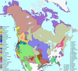
First Nations by linguistic-cultural area: List of First Nations peoples

First Nations peoples had settled and established trade routes across what is now Canada by 1,000 BC to 500 BC. Communities developed, each with its own culture, customs, and character. In the northwest were the Athapaskan-speaking peoples, Slavey, TƂı̨chÇ«, Tutchone-speaking peoples, and Tlingit. Along the Pacific coast were the Haida, Tsimshian, Salish, Kwakiutl, Nuu-chah-nulth, Nisga'a and Gitxsan. In the plains were the Blackfoot, Kainai, Sarcee and Northern Peigan. In the northern woodlands were the Cree and Chipewyan. Around the Great Lakes were the Anishinaabe, Algonquin, Iroquois and Wyandot. Along the Atlantic coast were the Beothuk, Maliseet, Innu, Abenaki and Mi'kmaq.

The Blackfoot Confederacy resides in the Great Plains of Montana and Canadian provinces of Alberta, British Columbia and Saskatchewan. The name Blackfoot came from the dye or paint on the bottoms the their leather moccasins. One account claimed that the Blackfoot Confederacies walked through the ashes of prairie fires, which in turn blackened the bottoms of their moccasins. They had migrated onto the Great Plains from the Plateau area. The Blackfoot may have lived in their homeland since the end of the Pleistocene 12,000 years ago. For thousands of years, they managed the prairie to support bison herds and cultivated berries and edible roots. Historically, they allowed only legitimate traders into their territory, making treaties only when the bison herds were exterminated in the 1870s.

Squamish woman

Pre-contact Squamish history is passed on through oral tradition of the Squamish indigenous peoples of the Pacific Northwest Coast. Prior to colonization and the introduction of writing had only oral tradition as a way to transmit stories, law, and knowledge across generations. The writing system established in the 1970s uses the Latin alphabet as a base. Knowledgeable elders have the responsibility to pass historical knowledge to the next generation. People lived and prospered for thousands of years until the Great Flood. In another story, after the Flood, they repopulated from the villages of Schenks and Chekwelp, located at Gibsons. When the water lines receded, the first Squamish came to be. The first man, named Tseបånchten, built his longhouse in the village, and later on another man named Xelålten, appeared on his longhouse roof and sent by the Creator, or in the Squamish language keke7nex siyam. He called this man his brother. It was from these two men that the population began to rise and the Squamish spread back through their territory.

A traditional Iroquois longhouse.

The Iroquois influence extended from northern New York into what are now southern Ontario and the Montreal area of modern Quebec. The Iroquois Confederacy is, from oral tradition, formed circa 1142. Adept at cultivating the Three Sisters (maize/beans/squash), the Iroquois became powerful because of their confederacy. Gradually the Algonquians adopted agricultural practises enabling larger populations to be sustained.

The Assiniboine were close allies and trading partners of the Cree, engaging in wars against the Gros Ventres alongside them, and later fighting the Blackfoot. A Plains people, they went no further north than the North Saskatchewan River and purchased a great deal of European trade goods through Cree middlemen from the Hudson's Bay Company. The lifestyle of this group was semi-nomadic, and they followed the herds of bison during the warmer months. They traded with European traders, and worked with the Mandan, Hidatsa, and Arikara tribes.

In the earliest oral history, the Algonquins were from the Atlantic coast. Together with other AnicinĂ pek, they arrived at the "First Stopping Place" near Montreal. While the other AnicinĂ pe peoples continued their journey up the St. Lawrence River, the Algonquins settled along the Ottawa River (KitcisĂŹpi), an important highway for commerce, cultural exchange, and transportation. A distinct Algonquin identity, though, was not realized until after the dividing of the AnicinĂ pek at the "Third Stopping Place", estimated at 2,000 years ago near present-day Detroit.

Details of Ojibwe Wigwam at Grand Portage by Eastman Johnson

According to their tradition, and from recordings in birch bark scrolls (wiigwaasabak), Ojibwe (an Algonquian-speaking people) came from the eastern areas of North America, or Turtle Island, and from along the east coast. They traded widely across the continent for thousands of years and knew of the canoe routes west and a land route to the west coast. According to the oral history, seven great miigis (radiant/iridescent) beings appeared to the peoples in the Waabanakiing to teach the peoples of the mide way of life. One of the seven great miigis beings was too spiritually powerful and killed the peoples in the Waabanakiing when the people were in its presence. The six great miigis beings remained to teach while the one returned into the ocean. The six great miigis beings then established doodem (clans) for the peoples in the east. Of these doodem, the five original Anishinaabe doodem were the Wawaazisii (Bullhead), Baswenaazhi (Echo-maker, i.e., Crane), Aan'aawenh (Pintail Duck), Nooke (Tender, i.e., Bear) and Moozoonsii (Little Moose), then these six miigis beings returned into the ocean as well. If the seventh miigis being stayed, it would have established the Thunderbird doodem.

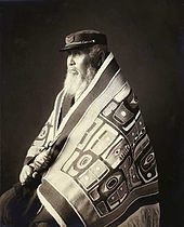
Chief Anotklosh of the Taku Tribe.

The Nuu-chah-nulth are one of the Indigenous peoples of the Pacific Northwest Coast. The term Nuu-chah-nulth is used to describe fifteen separate but related First Nations, such as the Tla-o-qui-aht First Nations, Ehattesaht First Nation and Hesquiaht First Nation whose traditional home is on the west coast of Vancouver Island. In pre-contact and early post-contact times, the number of nations was much greater, but smallpox and other consequences of contact resulted in the disappearance of groups, and the absorption of others into neighbouring groups. The Nuu-chah-nulth are relations of the Kwakwaka'wakw, the Haisla, and the Ditidaht. The Nuu-chah-nulth language is part of the Wakashan language group.

In 1999 the discovery of the body of KwĂ€day DĂ€n Ts'ĂŹnchi provided archaeologists with significant information on indigenous tribal life prior to extensive European contact. KwĂ€day DĂ€n Ts'ĂŹnchi (meaning "Long Ago Person Found" in Southern Tutchone), or "Canadian Ice Man", is a naturally mummified body that a group of hunters found in Tatshenshini-Alsek Provincial Park in British Columbia. Radiocarbon dating of artifacts found with the body placed the age of the find between 1450 AD and 1700 AD. Genetic testing showed that he was a member of the Champagne and Aishihik First Nations.

European contact

"Colour-coded map of North America showing the distribution of North American language families north of Mexico"

Aboriginal people in Canada interacted with Europeans as far back as 1000 AD, but prolonged contact came only after Europeans established permanent settlements in the 17th and 18th centuries. European written accounts noted friendliness on the part of the First Nations, who profited in trade with Europeans. Such trade strengthened the more organized political entities such as the Iroquois Confederation. The Aboriginal population is estimated to have been between 200,000 and two million in the late 15th century. The effect of European colonization was a 40 to 80 percent Aboriginal population decrease post-contact. This is attributed to various factors, including repeated outbreaks of European infectious diseases such as influenza, measles and smallpox (to which they had not developed immunity), inter-nation conflicts over the fur trade, conflicts with colonial authorities and settlers and loss of land and a subsequent loss of nation self-suffiency. For example, during the late 1630s, smallpox killed more than half of the Huron, who controlled most of the early fur trade in what became Canada. Reduced to fewer than 10,000 people, the Huron Wendat were attacked by the Iroquois, their traditional enemies. In the Maritimes, the Beothuk disappeared entirely.

There are reports of contact made before Christopher Columbus between the first peoples and those from other continents. Even in Columbus' time there was much speculation that other Europeans had made the trip in ancient or contemporary times; Gonzalo Fernåndez de Oviedo y Valdés records accounts of these in his General y natural historia de las Indias of 1526, which includes biographical information on Columbus. Aboriginal first contact period is not well defined. The earliest accounts of contact occurred in the late 10th century, between the Beothuk and Norsemen. According to the Sagas of Icelanders, the first European to see what is now Canada was Bjarni Herjólfsson, who was blown off course en route from Iceland to Greenland in the summer of 985 or 986 CE. The first European explorers and settlers of what is now Canada relied on the First Nations peoples, for resources and trade to sustain a living. The first written accounts of interaction show a predominantly Old world bias, labelling the indigenous peoples as "savages", although the indigenous peoples were organized and self-sufficient. In the early days of contact, the First Nations and Inuit populations welcomed the Europeans, assisting them in living off the land and joining forces with the French and British in their various battles. It was not until the colonial and imperial forces of Britain and France established dominant settlements and, no longer needing the help of the First Nations people, began to break treaties and force them off the land that the antagonism between the two groups grew.

16th–18th centuries

The Portuguese Crown claimed that it had territorial rights in the area visited by Cabot. In 1493 Pope Alexander VI – assuming international jurisdiction – had divided lands discovered in America between Spain and Portugal. The next year, in the Treaty of Tordesillas, these two kingdoms decided to draw the dividing line running north–south, 370 leagues (from 1,500 to 2,200 km (930 to 1,370 mi) approximately depending on the league used) west of the Cape Verde Islands. Land to the west would be Spanish, to the east Portuguese. Given the uncertain geography of the day, this seemed to give the "new founde isle" to Portugal. On the 1502 Cantino map, Newfoundland appears on the Portuguese side of the line (as does Brazil). An expedition captured about 60 Aboriginal people as slaves who were said to "resemble gypsies in colour, features, stature and aspect; are clothed in the skins of various animals ...They are very shy and gentle, but well formed in arms and legs and shoulders beyond description ...." Some captives, sent by Gaspar Corte-Real, reached Portugal. The others drowned, with Gaspar, on the return voyage. Gaspar's brother, Miguel Corte-Real, went to look for him in 1502, but also failed to return.

Non-indigenous land claims in North America, 1750–2008.

In 1604 King Henry IV of France granted Pierre Dugua, Sieur de Mons a fur-trade monopoly. Dugua led his first colonization expedition to an island located near to the mouth of the St. Croix River. Samuel de Champlain, his geographer, promptly carried out a major exploration of the northeastern coastline of what is now the United States. Under Samuel de Champlain, the Saint Croix settlement moved to Port Royal (today's Annapolis Royal, Nova Scotia), a new site across the Bay of Fundy, on the shore of the Annapolis Basin, an inlet in western Nova Scotia. Acadia became France's most successful colony to that time. The cancellation of Dugua's fur monopoly in 1607 ended the Port Royal settlement. Champlain persuaded First Nations to allow him to settle along the St. Lawrence, where in 1608 he would found France's first permanent colony in Canada at Quebec City. The colony of Acadia grew slowly, reaching a population of about 5,000 by 1713. New France had cod-fishery coastal communities, and farm economies supported communities along the St. Lawrence River. French voyageurs travelled deep into the hinterlands (of what is today Quebec, Ontario, and Manitoba, as well as what is now the American Midwest and the Mississippi Valley), trading with First Nations as they went – guns, gunpowder, cloth, knives, and kettles for beaver furs. The fur trade kept the interest in France's overseas colonies alive, yet only encouraged a small colonial population, as minimal labour was required. The trade also discouraged the development of agriculture, the surest foundation of a colony in the New World.

The MĂ©tis

The MĂ©tis (from French mĂ©tis – "mixed") are descendants of unions between Cree, Ojibwe, Algonquin, Saulteaux, Menominee and other First Nations in the 17th, 18th and 19th centuries and Europeans, mainly French. The MĂ©tis were historically the children of French fur traders and Nehiyaw women or, from unions of English or Scottish traders and Northern Dene women (Anglo-MĂ©tis). The MĂ©tis spoke or still speak either MĂ©tis French or a mixed language called Michif. Michif, Mechif or MĂ©tchif is a phonetic spelling of the MĂ©tis pronunciation of MĂ©tif, a variant of MĂ©tis. The MĂ©tis as of 2013 predominantly speak English, with French a strong second language, as well as numerous Aboriginal tongues. MĂ©tis French is best preserved in Canada, Michif in the United States, notably in the Turtle Mountain Indian Reservation of North Dakota, where Michif is the official language of the MĂ©tis that reside on this Chippewa reservation. The encouragement and use of MĂ©tis French and Michif is growing due to outreach within the five provincial MĂ©tis councils after at least a generation of steep decline. Canada's Indian and Northern Affairs define MĂ©tis to be those persons of mixed First Nation and European ancestry.

Colonial wars

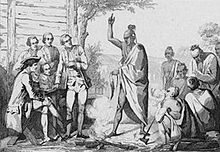
Conference between the French and First Nations leaders by Émile Louis Vernier.

Allied with the French, the first nations of the Wabanaki Confederacy of Acadia fought six colonial wars against the British and their native allies (See the French and Indian Wars, Father Rale's War and Father Le Loutre's War). In the second war, Queen Anne's War, the British conquered Acadia (1710). The sixth and final colonial war between the nations of France and Great Britain (1754–1763), resulted in the French giving up their claims and the British claimed the lands of Canada.

In this final war, the Franco-Indian alliance brought together Americans, First Nations and the French, centred on the Great Lakes and the Illinois Country. The alliance involved French settlers on the one side, and on the other side were the Abenaki, Odawa, Menominee, Ho-Chunk (Winnebago), Mississaugas, Illiniwek, Huron-Petun, Potawatomi etc. It allowed the French and the Indians to form a haven in the middle-Ohio valley before the open conflict between the European powers erupted.

In the Royal Proclamation of 1763, the British recognized the treaty rights of the indigenous populations and resolved to only settle those areas purchased lawfully from the indigenous peoples. Treaties and land purchases were made in several cases by the British, but the lands of several indigenous nations remain unceded and/or unresolved.

Slavery

First Nations routinely captured slaves from neighbouring tribes. Sources report that the conditions under which First Nations slaves lived could be brutal, with the Makah tribe practicing death by starvation as punishment and Pacific coast tribes routinely performing ritualized killings of slaves as part of social ceremonies into the mid-1800s. Slave-owning tribes of the fishing societies, such as the Yurok and Haida lived along the coast from what is now Alaska to California. Fierce warrior indigenous slave-traders of the Pacific Northwest Coast raided as far south as California. Slavery was hereditary, the slaves and their descendants being considered prisoners of war. Some tribes in British Columbia continued to segregate and ostracize the descendants of slaves as late as the 1970s. Among Pacific Northwest tribes about a quarter of the population were slaves.

The citizens of New France received slaves as gifts from their allies among First Nations peoples. Slaves were prisoners taken in raids against the villages of the Fox nation, a tribe that was an ancient rival of the Miami people and their Algonquian allies. Native (or "pani", a corruption of Pawnee) slaves were much easier to obtain and thus more numerous than African slaves in New France, but were less valued. The average native slave died at 18, and the average African slave died at 25 (the average European could expect to live until the age of 35). By 1790 the abolition movement was gaining ground in Canada and the ill intent of slavery was evidenced by an incident involving a slave woman being violently abused by her slave owner on her way to being sold in the United States. The Act Against Slavery of 1793 legislated the gradual abolition of slavery: no slaves could be imported; slaves already in the province would remain enslaved until death, no new slaves could be brought into Upper Canada, and children born to female slaves would be slaves but must be freed at age 25. The Act remained in force until 1833 when the British Parliament's Slavery Abolition Act finally abolished slavery in all parts of the British Empire. Historian Marcel Trudel has documented 4,092 recorded slaves throughout Canadian history, of which 2,692 were Aboriginal people, owned by the French, and 1,400 blacks owned by the British, together owned by approximately 1,400 masters. Trudel also noted 31 marriages took place between French colonists and Aboriginal slaves.

1775–1815

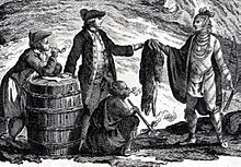
Fur traders in Canada, trading with First Nations, 1777

British agents worked to make the First Nations into military allies of the British, providing supplies, weapons, and encouragement. During the American Revolutionary War (1775–1783) most of the tribes supported the British. In 1779, the Americans launched a campaign to burn the villages of the Iroquois in New York State. The refugees fled to Fort Niagara and other British posts, and remained permanently in Canada. Although the British ceded the Old Northwest to the United States in the Treaty of Paris in 1783, it kept fortifications and trading posts in the region until 1795. The British then evacuated American territory, but operated trading posts in British territory, providing weapons and encouragement to tribes that were resisting American expansion into such areas as Ohio, Indiana, Michigan, Illinois and Wisconsin. Officially, the British agents discouraged any warlike activities or raids on American settlements, but the Americans became increasingly angered, and this became one of the causes of the War of 1812.

In the war, the great majority of First Nations supported the British, and many fought under the aegis of Tecumseh. But Tecumseh died in battle in 1813 and the Indian coalition collapsed. The British had long wished to create a neutral Indian state in the American Old Northwest, and made this demand as late as 1814 at the peace negotiations at Ghent. The Americans rejected the idea, the British dropped it, and Britain's Indian allies lost British support. In addition, the Indians were no longer able to gather furs in American territory. Abandoned by their powerful sponsor, Great Lakes-area natives ultimately assimilated into American society, migrated to the west or to Canada, or were relocated onto reservations in Michigan and Wisconsin. Historians have unanimously agreed that the Indians were the major losers in the War of 1812.

19th century

Assiniboine hunting buffalo, c. 1851

Living conditions for Indigenous people in the prairie regions deteriorated quickly. Between 1875 and 1885, settlers and hunters of European descent contributed to hunting the North American bison almost to extinction; the construction of the Canadian Pacific Railway brought large numbers of European settlers west who encroached on Indigenous territory. European Canadians established governments, police forces, and courts of law with different foundations from indigenous practices. Various epidemics continued to devastate Indigenous communities. All of these factors had a profound effect on Indigenous people, particularly those from the plains who had relied heavily on bison for food and clothing. Most of those nations that agreed to treaties had negotiated for a guarantee of food and help to begin farming. Just as the bison disappeared (the last Canadian hunt was in 1879), Lieutenant-Governor Edgar Dewdney cut rations to indigenous people in an attempt to reduce government costs. Between 1880 and 1885, approximately 3,000 Indigenous people starved to death in the North-Western Territory/Northwest Territories.

Offended by the concepts of the treaties, Cree chiefs resisted them. Big Bear refused to sign Treaty 6 until starvation among his people forced his hand in 1882. His attempts to unite Indigenous nations made progress. In 1884 the MĂ©tis (including the Anglo-MĂ©tis) asked Louis Riel to return from the United States, where he had fled after the Red River Rebellion, to appeal to the government on their behalf. The government gave a vague response. In March 1885, Riel, Gabriel Dumont, HonorĂ© Jackson (a.k.a. Will Jackson), Crowfoot, Chief of the Blackfoot First Nation and Chief Poundmaker, who after the 1876 negotiations of Treaty 6 split off to form his band. Together, they set up the Provisional Government of Saskatchewan, believing that they could influence the federal government in the same way as they had in 1869. The North-West Rebellion of 1885 was a brief and unsuccessful uprising by the MĂ©tis people of the District of Saskatchewan under Louis Riel against the Dominion of Canada, which they believed had failed to address their concerns for the survival of their people. In 1884, 2,000 Cree from reserves met near Battleford to organise into a large, cohesive resistance. Discouraged by the lack of government response but encouraged by the efforts of the MĂ©tis at armed rebellion, Wandering Spirit and other young militant Cree attacked the small town of Frog Lake, killing Thomas Quinn, the hated Indian Agent and eight others. Although Big Bear actively opposed the attacks, he was charged and tried for treason and sentenced to three years in prison. After the Red River Rebellion of 1869–1870, MĂ©tis moved from Manitoba to the District of Saskatchewan, where they founded a settlement at Batoche on the South Saskatchewan River.

Mi'kmaq Grand Chief Jacques-Pierre Peminuit Paul (3rd from left with beard) meets Governor General of Canada, Marquess of Lorne, Red Chamber, Province House, Halifax, Nova Scotia, 1879

In Manitoba settlers from Ontario began to arrive. They pushed for land to be allotted in the square concession system of English Canada, rather than the seigneurial system of strips reaching back from a river which the MĂ©tis were familiar with in their French-Canadian culture. The buffalo were being hunted to extinction by the Hudson's Bay Company and other hunters, as for generations the MĂ©tis had depended on them as a chief source of food.

Colonization and assimilation

St. Paul's Indian Industrial School, Manitoba, 1901

The history of colonization is complex, varied according to the time and place. France and Britain were the main colonial powers involved, though the United States also began to extend its territory at the expense of indigenous people as well.

From the late 18th century, European Canadians encouraged First Nations to assimilate into the European-based culture, referred to as "Canadian culture". The assumption was that this was the "correct" culture because the Canadians of European descent saw themselves as dominant, and technologically, politically and culturally superior. There was resistance against this assimilation and many businesses denied European practices. The Tecumseh Wigwam of Toronto, for example, did not adhere to the widely practiced Lord's Day observance, making it a popular spot, especially on Sundays. These attempts reached a climax in the late 19th and early 20th centuries.

Founded in the 19th century, the Canadian Indian residential school system was intended to force the assimilation of Aboriginal and First Nations people into European-Canadian society. The purpose of the schools, which separated children from their families, has been described by commentators as "killing the Indian in the child."

Buying provisions, Hudson's Bay territory, 1870s

Funded under the Indian Act by Indian and Northern Affairs Canada, a branch of the federal government, the schools were run by churches of various denominations – about 60% by Roman Catholics, and 30% by the Anglican Church of Canada and the United Church of Canada, along with its pre-1925 predecessors, Presbyterian, Congregationalist and Methodist churches.

The attempt to force assimilation involved punishing children for speaking their own languages or practicing their own faiths, leading to allegations in the 20th century of cultural genocide and ethnocide. There was widespread physical and sexual abuse. Overcrowding, poor sanitation, and a lack of medical care led to high rates of tuberculosis, and death rates of up to 69%. Details of the mistreatment of students had been published numerous times throughout the 20th century, but following the closure of the schools in the 1960s, the work of indigenous activists and historians led to a change in the public perception of the residential school system, as well as official government apologies, and a (controversial) legal settlement.

Colonization had a significant impact on First Nations diet and health. According to the historian Mary-Ellen Kelm, "inadequate reserve allocations, restrictions on the food fishery, overhunting, and over-trapping" alienated First Nations from their traditional way of life, which undermined their physical, mental, emotional, and spiritual health.

20th century

Ethnomusicologist Frances Densmore recording Blackfoot chief Mountain Chief (1916)

As Canadian ideas of progress evolved around the start of the 20th century, the federal Indian policy was directed at removing Indigenous people from their communal lands and encouraging assimilation. Amendments to the Indian Act in 1905 and 1911 made it easier for the government to expropriate reserve lands from First Nations. The government sold nearly half of the Blackfoot reserve in Alberta to settlers.

When the Kainai (Blood) Nation refused to accept the sale of their lands in 1916 and 1917, the Department of Indian Affairs held back funding necessary for farming until they relented. In British Columbia, the McKenna–McBride Royal Commission was created in 1912 to settle disputes over reserve lands in the province. The claims of Indigenous people were ignored, and the commission allocated new, less valuable lands (reserves) for First Nations.

Those nations who managed to maintain their ownership of good lands often farmed successfully. Indigenous people living near the Cowichan and Fraser rivers, and those from Saskatchewan managed to produce good harvests. Since 1881, those First Nations people living in the prairie provinces required permits from Indian Agents to sell any of their produce. Later the government created a pass system in the old Northwest Territories that required indigenous people to seek written permission from an Indian Agent before leaving their reserves for any length of time. Indigenous people regularly defied those laws, as well as bans on Sun Dances and potlatches, in an attempt to practice their culture.

The 1930 Constitution Act or Natural Resources Acts was part of a shift acknowledging indigenous rights. It enabled provincial control of Crown land and allowed Provincial laws regulating game to apply to Indians, but it also ensured that "Indians shall have the right ... of hunting, trapping and fishing game and fish for food at all seasons of the year on all unoccupied Crown lands and on any other lands to which the said Indians may have a right of access."

First and Second World Wars

Aboriginal War Veterans monument

More than 6,000 First Nations, Inuit and MĂ©tis served with British forces during First World War and Second World War. A generation of young native men fought on the battlefields of Europe during the Great War and approximately 300 of them died there. When Canada declared war on Germany on September 10, 1939, the native community quickly responded to volunteer. Four years later, in May 1943, the government declared that, as British subjects, all able Indian men of military age could be called up for training and service in Canada or overseas.

Late 20th century

Following the end of the Second World War, laws concerning First Nations in Canada began to change, albeit slowly. The federal prohibition of potlatch and Sun Dance ceremonies ended in 1951. Provincial governments began to accept the right of Indigenous people to vote. In June 1956, section 9 of the Citizenship Act was amended to grant formal citizenship to Status Indians and Inuit, retroactively as of January 1947.

In 1960, First Nations people received the right to vote in federal elections without forfeiting their Indian status. By comparison, Native Americans in the United States had been allowed to vote since the 1920s.

1969 White Paper

In his 1969 White Paper, then-Minister of Indian Affairs, Jean Chrétien, proposed the abolition of the Indian Act of Canada, the rejection of Aboriginal land claims, and the assimilation of First Nations people into the Canadian population with the status of "other ethnic minorities" rather than as a distinct group.

Harold Cardinal and the Indian Chiefs of Alberta responded with a document entitled "Citizens Plus" but commonly known as the "Red Paper". In it, they explained Status Indians' widespread opposition to Chrétien's proposal. Prime Minister Pierre Trudeau and the Liberals began to back away from the 1969 White Paper, particularly after the Calder case decision in 1973. After the Canadian Supreme Court recognized that indigenous rights and treaty rights were not extinguished, a process was begun to resolve land claims and treaty rights and is ongoing today.

Health transfer policy

In 1970, severe mercury poisoning, called Ontario Minamata disease, was discovered among Asubpeeschoseewagong First Nation and Wabaseemoong Independent Nations people, who lived near Dryden, Ontario. There was extensive mercury pollution caused by Dryden Chemicals Company's waste water effluent in the Wabigoon-English River system. Because local fish were no longer safe to eat, the Ontario provincial government closed the commercial fisheries run by the First Nation people and ordered them to stop eating local fish. Previously it had made up the majority of their diet. In addition to the acute mercury poisoning in northwestern Ontario, Aamjiwnaang First Nation people near Sarnia, Ontario, experienced a wide range of chemical effects, including severe mercury poisoning. They suffered low birth rates, skewed birth-gender ratio, and health effects among the population. This led to legislation and eventually the Indian Health Transfer Policy that provided a framework for the assumption of control of health services by First Nations people, and set forth a developmental approach to transfer centred on the concept of self-determination in health. Through this process, the decision to enter into transfer discussions with Health Canada rests with each community. Once involved in transfer, communities are able to take control of health programme responsibilities at a pace determined by their individual circumstances and health management capabilities.

The capacity, experience and relationships developed by First Nations as a result of health transfer was a factor that assisted the creation of the First Nations Health Authority in British Columbia.

Elijah Harper and the Meech Lake Accord

In 1981, Elijah Harper, a Cree from Red Sucker Lake, Manitoba, became the first "Treaty Indian" in Manitoba to be elected as a member of the Legislative Assembly of Manitoba. In 1990, Harper achieved national fame by holding an eagle feather as he refused to accept the Meech Lake Accord, a constitutional amendment package negotiated to gain Quebec's acceptance of the Constitution Act, 1982, but also one that did not address any First Nations grievances. The accord was negotiated in 1987 without the input of Canada's Aboriginal peoples. The third, final constitutional conference on Aboriginal peoples was also unsuccessful. The Manitoba assembly was required to unanimously consent to a motion allowing it to hold a vote on the accord, because of a procedural rule. Twelve days before the ratification deadline for the Accord, Harper began a filibuster that prevented the assembly from ratifying the accord. Because Meech Lake failed in Manitoba, the proposed constitutional amendment failed. Harper also opposed the Charlottetown Accord in 1992, even though Assembly of First Nations Chief Ovide Mercredi supported it.

Women's status and Bill C-31

According to the Indian Act, status Indian women who married men who were not status Indians lost their treaty status, and their children would not get status. However, in the reverse situation, if a status Indian man married a woman who was not a status Indian, the man would keep his status and his children would also receive treaty status. In the 1970s, the Indian Rights for Indian Women and Native Women's Association of Canada groups campaigned against this policy because it discriminated against women and failed to fulfill treaty promises. They successfully convinced the federal government to change the section of the act with the adoption of Bill C-31 on June 28, 1985. Women who had lost their status and children who had been excluded were then able to register and gain official Indian status. Despite these changes, status Indian women who married men who were not status Indians could pass their status on only one generation: their children would gain status, but (without a marriage to a full-status Indian) their grandchildren would not. A status Indian man who married a woman who was not a status Indian retained status as did his children, but his wife did not gain status, nor did his grandchildren.

Bill C-31 also gave elected bands the power to regulate who was allowed to reside on their reserves and to control development on their reserves. It abolished the concept of "enfranchisement" by which First Nations people could gain certain rights by renouncing their Indian status.

Erasmus–Dussault commission

In 1991, Prime Minister Brian Mulroney created the Royal Commission on Aboriginal Peoples chaired by René Dussault and Georges Erasmus. Their 1996 report proposed the creation of a government for (and by) the First Nations that would be responsible within its own jurisdiction, and with which the federal government would speak on a "Nation-to-Nation" basis. This proposal offered a far different way of doing politics than the traditional policy of assigning First Nations matters under the jurisdiction of the Indian and Northern Affairs, managed by one minister of the federal cabinet. The report also recommended providing the governments of the First Nations with up to $2 billion every year until 2010, in order to reduce the economic gap between the First Nations and the rest of the Canadian citizenry. The money would represent an increase of at least 50% to the budget of Indian and Northern Affairs. The report engaged First Nations leaders to think of ways to cope with the challenging issues their people were facing, so the First Nations could take their destiny into their own hands.

The federal government, then headed by Jean Chrétien, responded to the report a year later by officially presenting its apologies for the forced acculturation the federal government had imposed on the First Nations, and by offering an "initial" provision of $350 million.

In the spirit of the Eramus–Dussault commission, tripartite (federal, provincial, and First Nations) accords have been signed since the report was issued. Several political crises between different provincial governments and different bands of the First Nations also occurred in the late 20th century, notably the Oka Crisis, Ipperwash Crisis, Burnt Church Crisis, and the Gustafsen Lake standoff.

Early 21st century

In 2001, the Quebec government, the federal government, and the Cree Nation signed "La Paix des Braves" (The Peace of the Braves, a reference to the 1701 peace treaty between the French and the Iroquois League). The agreement allowed Hydro-Québec to exploit the province's hydroelectric resources in exchange for an allocation of $3.5 billion to be given to the government of the Cree Nation. Later, the Inuit of northern Quebec (Nunavik) joined in the agreement.

Defence of Cree rights

In 2005, the leaders of the First Nations, various provincial governments, and the federal government produced an agreement called the Kelowna Accord, which would have yielded $5 billion over 10 years, but the new federal government of Stephen Harper (2006) did not follow through on the working paper. First Nations, along with the MĂ©tis and the Inuit, have claimed to receive inadequate funding for education, and allege their rights have been overlooked. James Bartleman, Lieutenant Governor of Ontario from 2002 to 2007, listed the encouragement of indigenous young people as one of his key priorities. During his term, he launched initiatives to promote literacy and bridge-building. Bartleman was the first Aboriginal person to be lieutenant governor in Ontario.

In 2006, 76 First Nations communities had boil-water advisory conditions. In late 2005, the drinking water crisis of the Kashechewan First Nation received national media attention when E. coli was discovered in their water supply system, following two years of living under a boil-water advisory. The drinking water was supplied by a new treatment plant built in March 1998. The cause of the tainted water was a plugged chlorine injector that was not discovered by local operators, who were not qualified to be running the treatment plant. When officials arrived and fixed the problem, chlorine levels were around 1.7 mg/l, which was blamed for skin disorders such as impetigo and scabies. An investigation led by Health Canada revealed that skin disorders were likely due to living in squalor. The evacuation of Kashechewan was largely viewed by Canadians as a cry for help for other underlying social and economic issues that Aboriginal people in Canada face.

On June 29, 2007, Canadian Aboriginal groups held countrywide protests aimed at ending First Nations poverty, dubbed the Aboriginal Day of Action. The demonstrations were largely peaceful, although groups disrupted transportation with blockades or bonfires; a stretch of the Highway 401 was shut down, as was the Canadian National Railway's line between Toronto and Montreal.

The Idle No More protest movement originated among the Aboriginals in Canada and their non-Aboriginal supporters in Canada, and to a lesser extent, internationally. It consisted of a number of political actions worldwide, inspired in part by the hunger strike of Attawapiskat First Nation Chief Theresa Spence and further coordinated via social media. A reaction to alleged abuses of indigenous treaty rights by the federal government, the movement took particular issue with the omnibus bill Bill C-45.

Canadian Crown and First Nations relations

David Laird explaining terms of Treaty 8, Fort Vermilion, 1899

The relationship between the Canadian Crown and the First Nations, Inuit, and Métis peoples stretches back to the first interactions between European colonialists and North American indigenous people. Over centuries of interaction, treaties were established, and First Nations have, like the Māori and the Treaty of Waitangi in New Zealand, come to generally view these agreements as being between them and the Crown of Canada, and not the ever-changing governments.

The associations exist between the Aboriginal peoples and the reigning monarch of Canada; as was stated in the proposed First Nations – Federal Crown Political Accord: "cooperation will be a cornerstone for partnership between Canada and First Nations, wherein Canada is the short-form reference to Her Majesty the Queen in Right of Canada". These relations are governed by the established treaties; the Supreme Court stated that treaties "served to reconcile pre-existing Aboriginal sovereignty with assumed Crown sovereignty, and to define Aboriginal rights", and the First Nations saw these agreements as meant to last "as long as the sun shines, grass grows and rivers flow".

Taxation

Although taxes are not specifically addressed in the written terms of any treaties, assurances regarding taxation were clearly offered when at least some treaties were negotiated.

The various statutory exemptions from taxation are established under the Indian Act, which reads:

  • 87(1). Notwithstanding any other Act of Parliament or any Act of the legislature of a province ... the following property is exempt from taxation
    • (a) the interest of an Indian or a band in reserve lands or surrendered lands; and
    • (b) the personal property of an Indian or a band situated on a reserve.
  • 87(2). No Indian or band is subject to taxation in respect of the ownership, occupation, possession or use of any property mentioned in paragraph (1)(a) or (b) or is otherwise subject to taxation in respect of any such property.

Many scholars believe these exemptions serve to oppress Aboriginal peoples by allowing conservative-minded courts to impart their own (sometimes discriminatory) views into the Aboriginal taxation jurisprudence. As one professor wrote:

[Because] income-generating activity in the "commercial mainstream" contrasts with income-generating activity that is "intimately connected to" the reserve ... [the] Tax Court of Canada implie[s] that the "traditional way of life" of Aboriginal peoples d[oes] not embrace "economic aspects" ... beyond a subsistence economy. [footnotes omitted] 

Political organization

Self-government has given chiefs and their councils powers which combine those of a province, school board, health board and municipality. Councils are also largely self-regulating regarding utilities, environmental protection, natural resources, building codes, etc. There is concern that this wide-ranging authority, concentrated in a single council, might be a cause of the dysfunctional governments experienced by many First Nations.

"Ovide Mercredi speaking to the media"
Ovide Mercredi, former national chief of the Assembly of First Nations

The Assembly of First Nations (AFN) is a body of First Nations leaders in Canada. The aims of the organization are to protect the rights, treaty obligations, ceremonies, and claims of citizens of the First Nations in Canada.

After the failures of the League of Indians in Canada in the interwar period and the North American Indian Brotherhood in two decades following the Second World War, the Aboriginal peoples of Canada organised themselves once again in the early 1960s. The National Indian Council was created in 1961 to represent Indigenous people, including treaty/status Indians, non-status people, the MĂ©tis people, though not the Inuit. This organization collapsed in 1968 as the three groups failed to act as one, so the non-status and MĂ©tis groups formed the Native Council of Canada and treaty/status groups formed the National Indian Brotherhood (NIB), an umbrella group for provincial and territorial First Nations organizations.

Culture

National Indigenous Peoples Day, formerly National Aboriginal Day, June 21, recognizes the cultures and contributions of Aboriginal peoples of Canada. There are currently over 600 recognized First Nations governments or bands encompassing 1,172,790 people spread across Canada with distinctive Aboriginal cultures, languages, art, and music.

Languages

Today, there are over thirty different languages spoken by indigenous people, most of which are spoken only in Canada. Many are in decline. Those with the most speakers include Anishinaabe and Cree (together totalling up to 150,000 speakers); Inuktitut with about 29,000 speakers in the Northwest Territories, Nunavut, Nunavik (Northern Quebec), and Nunatsiavut (Northern Labrador); and Mi'kmaq, with around 8,500 speakers, mostly in Eastern Canada. Many Aboriginal peoples have lost their native languages and often all but surviving elders speak English or French as their first language.

Two of Canada's territories give official status to native languages. In Nunavut, Inuktitut and Inuinnaqtun are official languages alongside English and French, and Inuktitut is a common vehicular language in government. In the Northwest Territories, the Official Languages Act declares that there are eleven different languages: Chipewyan, Cree, English, French, Gwich'in, Inuinnaqtun, Inuktitut, Inuvialuktun, North Slavey, South Slavey and TƂįchÇ«. Besides English and French, these languages are not vehicular in government; official status entitles citizens to receive services in them on request and to deal with the government in them.

Art

Haida totem pole, Thunderbird Park, Victoria, British Columbia

First Nations were producing art for thousands of years before the arrival of European settler colonists and the eventual establishment of Canada as a nation state. Like the peoples who produced them, indigenous art traditions spanned territories across North America. Indigenous art traditions are organized by art historians according to cultural, linguistic or regional groups: Northwest Coast, Plateau, Plains, Eastern Woodlands, Subarctic, and Arctic.

Art traditions vary enormously amongst and within these diverse groups. Indigenous art with a focus on portability and the body is distinguished from European traditions and its focus on architecture. Indigenous visual art may be used in conjunction with other arts. Shamans' masks and rattles are used ceremoniously in dance, storytelling and music. Artworks preserved in museum collections date from the period after European contact and show evidence of the creative adoption and adaptation of European trade goods such as metal and glass beads. During the 19th and the first half of the 20th century the Canadian government pursued an active policy of forced and cultural assimilation toward indigenous peoples. The Indian Act banned manifestations of the Sun Dance, the Potlatch, and works of art depicting them.

It was not until the 1950s and 1960s that indigenous artists such as Mungo Martin, Bill Reid and Norval Morrisseau began to publicly renew and re-invent indigenous art traditions. Currently there are indigenous artists practising in all media in Canada and two indigenous artists, Edward Poitras and Rebecca Belmore, have represented Canada at the Venice Biennale in 1995 and 2005 respectively.

Music

Pow-wow at Eel Ground First Nation
 

The First Nations peoples of Canada comprise diverse ethnic groups, each with their own musical traditions. There are general similarities in the music, but is usually social (public) or ceremonial (private). Public, social music may be dance music accompanied by rattles and drums. Private, ceremonial music includes vocal songs with accompaniment on percussion, used to mark occasions like Midewiwin ceremonies and Sun Dances.

Traditionally, Aboriginal peoples used the materials at hand to make their instruments for centuries before Europeans immigrated to Canada. First Nations people made gourds and animal horns into rattles, which were elaborately carved and beautifully painted. In woodland areas, they made horns of birch bark and drumsticks of carved antlers and wood. Traditional percussion instruments such as drums were generally made of carved wood and animal hides. These musical instruments provide the background for songs, and songs are the background for dances. Traditional First Nations people consider song and dance to be sacred. For years after Europeans came to Canada, First Nations people were forbidden to practice their ceremonies.

Demographics

In the 20th century, the First Nations population of Canada increased tenfold. Between 1900 and 1950 the population grew only by 29% but after the 1960s the infant mortality level on reserves dropped and the population grew by 161%. Since the 1980s, the number of First Nations babies more than doubled and currently almost half of the First Nations population is under the age of 25. As a result, the First Nations population of Canada is expected to increase in the coming decades.

In 2016, there were 1,673,785 Aboriginal people in Canada, accounting for 4.9% of the total population. This was up from 3.8% in 2006.

PE
NS
NL
NT
NU
Canadian Provinces and Territories
First Nations by Province or Territory

There are distinct First Nations in Canada, originating across the country. Indian reserves, established in Canadian law by treaties such as Treaty 7, are the very limited contemporary lands of First Nations recognized by the non-indigenous governments. A few reserves exist within cities, such as the Opawikoscikan Reserve in Prince Albert, Wendake in Quebec City or Enoch Cree Nation 135 in the Edmonton Metropolitan Region. There are more reserves in Canada than there are First Nations, as First Nations were ceded multiple reserves by treaty.

People who self-identify as having North American Indian ancestors are the plurality in large areas of Canada (areas coloured in brown).

First Nations can be grouped into cultural areas based on their ancestors' primary lifeway, or occupation, at the time of European contact. These culture areas correspond closely with physical and ecological regions of Canada.

Ethnographers commonly classify indigenous peoples of the Americas in the United States and Canada into ten geographical regions with shared cultural traits (called cultural areas). The Canadian (in whole or in part) regions are Arctic, Subarctic, Northeast Woodlands, Plains, and Plateau. See the individual article on each tribe, band society or First Nation.

The Indigenous peoples of the Pacific Northwest Coast communities centred around ocean and river fishing; in the interior of British Columbia, hunting and gathering and river fishing. In both of these areas, salmon was of chief importance. For the people of the plains, bison hunting was the primary activity. In the subarctic forest, other species such as the moose were more important. For peoples near the Great Lakes and the St. Lawrence River, shifting agriculture was practised, including the raising of maize, beans, and squash.

Today, Aboriginal people work in a variety of occupations and live outside their ancestral homes. The traditional cultures of their ancestors, shaped by nature, still exert a strong influence on their culture, from spirituality to political attitudes.

Contemporary issues

First Nations peoples face a number of problems to a greater degree than Canadians overall, some with living conditions comparable to developing countries like Haiti. Indigenous peoples have higher rates of unemployment, rates of incarceration, substance abuse, health problems, homelessness, fetal alcohol syndrome, lower levels of education and higher levels of poverty.

Residential schools

Canada's federal residential school system began in the mid-1870s, building upon a patchwork of boarding schools established and operated by various Christian denominations. Member of Parliament for Assiniboia West, Nicholas Flood Davin, produced a report, known generally as the Davin Report, that recommended the establishment of a school system similar to that being created in the United States. One of its chief goals was to remove Aboriginal children from "the influence of the wigwam", which he claimed was stronger than that of existing day schools, and keep them instead "constantly within the circle of civilized conditions". While the history of the Indian Residential School system (IRS) is a checkered one, much criticism has been levelled at both the system and those who established and supported it. Neglect and poor nutrition were often what Aboriginal children experienced, particularly in the early decades of the system's operation. The stripping away of traditional native culture—sometimes referred to as "cultural genocide"—is another charge levelled at the residential schools. In many schools, students were not allowed to speak their Indigenous languages or practice any of their own customs, and thus lost their sense of identity, inevitably driving a cultural wedge between children and their family.

By 1920, attendance at some sort of school was mandatory for Aboriginal children in Canada. The Indian Act made education compulsory, and where there were no federal days schools—or, in later decades, a provincial public school—a residential school was the only choice. Enrolment statistics indicate that between 20% and 30% of Aboriginal children during the history of the IRS system attended a residential school for at least a year, and many were enrolled for ten years or more. In some cases, children could return home on weekends and holidays, but for those in schools established far away from remote communities, this was not possible.

The removal of children from their families and communities brought short and long term harm to many native communities. While many schools had infirmaries and provided medical care in later decades, abuse of various kinds and crowded conditions in the first decades of the IRS history led to poor health and even death for a percentage of those enrolled. It has been argued that the psychological and emotional trauma resulting from both the abuse and the removal of the children from their families and culture has resulted in substance abuse, greater domestic violence, unemployability, and increased rates of suicide. In many cases, children leaving residential schools found themselves at an intersection of cultures, where they were no longer comfortable within their own cultures, yet not accepted into mainstream Canadian culture. Former students are now routinely referred to as "survivors".

Not all Aboriginal children attended residential schools. During the period in which the schools operated, more than a third of indigenous children attended federal day schools, and about a third received no schooling at all. It is however the residential school system that receives much of the blame for the various problems and challenges facing Canada's indigenous people today. During the years in which the residential schools operated, they were regarded by most Canadians as a sensible and beneficial solution to native education, and in some cases, Aboriginal communities specifically requested that a residential school be built. When the system began to closing down in the 1960s, a significant number of communities asked that their school remain open.

The last Canadian residential school to close was Gordon Indian Residential School in Saskatchewan, founded in 1889, and closed in 1996.

The Christian denominations that operated the schools on behalf of the federal government have expressed regret and issued apologies for their part in a system that harmed many indigenous children. In 2008, the government issued an official apology to the students who were forced to attend the residential schools and their families.

In June 2015, the federally-established Truth and Reconciliation Commission, charged with investigating and reporting on the residential school system, issued its summary report, and in December of the same year, its final report. Chief Commissioner, Judge Murray Sinclair, has publicly declared the residential school system a deliberate act of cultural genocide against First Nations peoples. In its report, the commission submitted 94 recommendations to the Canadian government, recommendations which, if implemented, would substantially improve indigenous race relations, increase quality of life for survivors and extended families, and help undo the damage caused by residential schools. While the Liberal government, under Prime Minister Justin Trudeau, has committed itself to improving the lives of Canada's indigenous people, and specifically to implementing the TRC recommendations, some of those recommendations may be beyond the power of the Canadian government. The countless research documents assembled by the TRC will be archived in a special repository at the University of Manitoba.

Employment

The income of women with status living off-reserve was on average $13,870 a year, according to a 1996 Canadian census. This is about $5500 less than non-Indigenous women, such as Inuit and MĂ©tis women, which recorded slightly higher average annual incomes; regardless of the small discrepancy, all of which are substantially less than Statistics Canada's estimated amount of which an individual living in a large Canadian city would require to meet their needs. It is not unlikely for Aboriginal women living in poverty to not only tend to their own needs, but often tend to the needs of their elderly parents, care for loved ones in ill-health, as well as raising children; all of which is often supported only on a single income. It is believed that homelessness and inadequate shelter are widespread problems facing Aboriginal families, in all settings.

Self governance

A paramount conclusion by the Royal Commission on Aboriginal Peoples is that the repeated assaults on the culture and collective identity of the Aboriginal people has resulted in a weakened foundation of Aboriginal society and has contributed to the alienation that inevitably drives some to self-destructive and antisocial behaviour. The social problems among Aboriginal people are, in large measure, a legacy of history.

Crime and incarceration

Aboriginals are also more likely to be the victims of crime. This is particularly true in the younger population (aged 15–34), where acts of violence are two and a half times more likely to occur than in the older population. Domestic violence and sexual abuse against children is more prevalent in the Aboriginal population with sexual abuse affecting 25–50% of Aboriginal female children versus 20–25% of female children in the general population. Children who come from homes with a history of violence are at a greater risk of becoming the perpetrators of violence later in life. This is especially true of males.

As of 2007, 17% of incarcerated individuals in Canada were of Aboriginal descent, despite representing only 2.7% of the general population. This is a sixfold increase in rates of incarceration within the Aboriginal population as opposed to the general Canadian population. There are many reasons for the over-representation of Aboriginals within the Canadian justice system. Lack of education, poverty, unemployment and abuse all lead to higher crime rates. Also, statistically, Aboriginals have a greater chance of conviction and subsequently, incarceration once convicted. They are also much less likely to receive parole during their sentence.

Health

The Canadian federal government is responsible for health and social services on the reserve and in Inuit communities, while the provincial and territorial governments provide services elsewhere. The divide between each level of government has led to a gap in services for Aboriginal people living off-reserve and in Canadian towns and cities. Although Aboriginal people living off-reserve have access to the programs and services designed for the general population, these programs and services do not address the specific needs of Aboriginal people, nor is it delivered in a culturally appropriate way. It has not been until recently that the Canadian federal government had to increase recognition to the needs for programs and services for Aboriginal people in predominantly non-Aboriginal communities. It is however funding that lags the growth of urban Aboriginal populations and the uncoordinated delivery of services through various government departments would also pose as a barrier. The federal Interlocutor for MĂ©tis and Non-Status Indians pointed out that in 2003 almost 90 percent of the funding for programs designed for Aboriginal peoples is spent on reserves, while off-reserve programs for Aboriginal people are delivered through just 22 federal departments, as well as other provincial and territorial agencies. The federal subcommittee on Indigenous child welfare described a "jurisdictional web" in which there is little to no coordination with or between municipal, provincial and federal levels of government.

The health care services available to Aboriginal people is rarely delivered in a culturally sensitive approach. It is the constant cast of "the other" by the settler Canadian population that contaminates the delivery of such necessary services to Aboriginal peoples. It was argued by Ontario finance minister Jim Flaherty in 1992 that the Canadian government could boost health-care funding for "real people in real towns" by cutting the bureaucracy that serves only Aboriginal peoples. These types of statements, especially made by people often heard by a greater audience, are said to have detrimental and influential effects on the overall attitudes of settler population folks, as well as Aboriginal peoples.

Diabetes

There are marked differences between the epidemiology of diabetes in First Nation population compared to the general population. Reasons for the different rate of Type 2 Diabetes between First Nation and the general population include a complex combination of environmental (lifestyle, diet, poverty) and genetic and biological factors (e.g. thrifty genotype hypothesis, thrifty phenotype)  – though to what extent each factor plays a role is still not clear.

The Aboriginal population in Canada (First Nations, Inuit and MĂ©tis) have a significantly higher prevalence rate of diabetes than the non-Aboriginal population. Age-standardized rates show that the prevalence of diabetes among First Nations individuals living on-reserve is 17.2%; First Nations individuals living off-reserve is 10.3%; MĂ©tis individuals 7.3%; and non-Aboriginal peoples at 5.0%. It is important to note that Aboriginal individuals are generally diagnosed at a younger age than non-Aboriginal individuals, and Aboriginal females experience higher rates of gestational diabetes than non-Aboriginal females. The complications and prevalence of diabetes are seen among the Aboriginal population more often than non-Aboriginal population. These may be attributed to the socio-cultural, biological, environmental and lifestyle changes seen in the First Nations, Inuit, and MĂ©tis populations, which have been most especially prevalent in the last half century, all of which contributing significantly to the increased rates of diabetes and the complications associated among the Aboriginal population.

Substance-use disorders

First Nations in Canada engage in a disproportionate amount of substance abuse. In Vancouver, Indigenous people were faced with almost 18 per cent of drug charges, but are just 2.2 per cent of the city's population. A much higher proportion of First Nations people engage in heavy drinking weekly (16%) as opposed to the general population (8%). 19% of First Nations also reported cocaine and opiates use, higher than 13% of the general Canadian population that reported using opioids.

Life expectancy

Life expectancy at birth is significantly lower for First Nations babies than for babies in the Canadian population as a whole. As of 2001, Indian and Northern Affairs Canada estimates First Nations life expectancy to be 8.1 years shorter for males and 5.5 years shorter for females. Where females in the general population had a life expectancy at birth of 82 years, First Nations females had a life expectancy of 76 years. In males the life expectancy for First Nations individuals was 69 years as opposed to 77 in the general population. The reasons behind the lower life expectancy for First Nations individuals are varied and complex; however, social determinants of health are thought to play a large part.

Suicide

Overall, First Nations individuals have some of the highest rates of suicide globally. Suicide rates are more than twice the sex-specific rate and also three times the age-specific rates of non-Aboriginal Canadians. Residential Aboriginals between ages 10 and 29 show an elevated suicide risk as compared to non-residential Aboriginals by 5–6 times. One theory for the increased incidences of suicide within Aboriginal populations as compared to the general Canadian population is called acculturation stress which results from the intersection of multiple cultures within one's life. This leads to differing expectations and cultural clashes within the community, the family and the individual. At the community level, a general economic disadvantage is seen, exacerbated by unemployment and low education levels, leading to poverty, political disempowerment and community disorganization. The family suffers through a loss of tradition as they attempt to assimilate into mainstream Canadian culture. These lead to low self-esteem in the individual as First Nations culture and tradition are marginalized affecting one's sense of self-identity. These factors combine to create a world where First Nations individuals feel they cannot identify completely as Aboriginal, nor can they fully identify as mainstream Canadians. When that balance cannot be found, many (particularly youths) turn to suicide as a way out.

Drinking water

400 First Nations communities in Canada had some kind of water problem between 2004 and 2014. The residents of Neskantaga First Nation in Ontario have had a boil-water advisory since 1995. In 2015, newly elected Prime Minister Justin Trudeau promised to solve the drinking water problem within five years, by investing $1.8 billion. As of October 2021, long-term boil water advisories are still present in 32 First Nations drinking water systems.

Land claims

Across Canada, many First Nations have not signed treaties with the Canadian Crown. Many First Nations are in the process of negotiating a modern treaty, which would grant them treaty rights. Some First Nation bands are also trying to resolve their historical grievances with the Canadian government. These grievances often originate from a breach of treaty obligations or of the Indian Act by the government of Canada. They can also involve mismanagement of indigenous land or assets by the Crown.

Missing and murdered women

Across Canada, there has been a large number of missing and murdered Aboriginal women since 1980. 16% of female murder victims and 12% of missing women have been Aboriginal, while demographically they constitute only 4% of the overall female population. This amounts to almost 1,200 Aboriginal females either missing or murdered in just over 30 years.

In 2014 the Royal Canadian Mounted Police (RCMP) released Missing and Murdered Aboriginal Women: A National Operational Review. This publication documents the official findings of this demographic as well as advises for future change. It finds that there are 164 Aboriginal women still missing and 1,017 murdered, making for a total of 1,181. "There are 225 unsolved cases of either missing or murdered Aboriginal females: 105 missing for more than 30 days as of November 4, 2013, whose cause of disappearance was categorized as 'unknown' or 'foul play suspected' and 120 unsolved homicides between 1980 and 2012." Indigenous women in Canada are overrepresented among the missing and murdered females in Canada. Additionally, there are shared characteristics among these cases: most of the murders were committed by men and were someone the victim knew, either a partner or an acquaintance. "Aboriginal women between the ages of 25 and 44 are 5 times more likely than other women of the same age to die as a result of violence." These statistics portray the severity and prevalence of violence against indigenous women in Canada.

Self-governance and preservation of indigenous territories become increasingly difficult as natural resources continue to be exploited by foreign companies. Projects such as "mining, logging, hydroelectric construction, large-scale export oriented agribusiness or oil exploration" are usually coupled with environmental degradation and occasionally violence and militarization." Many scholars go so far as to link the proliferation of global neoliberalism with a rise in violence. Women's concerns are nearly always pushed aside, to be addressed later; their safety is therefore often compromised and not deemed priority. Privatization of public services and reduction in the universality of health care produces negative repercussions for those of lower socioeconomic status in rural locations; these downsides are magnified for female Aboriginals.

Missing and murdered men

Approximately 2,500 aboriginal people were murdered in Canada between 1982 and 2011, out of 15,000 murders in Canada overall. Of the 2,500 murdered aboriginal Canadians, fully 71 per cent — 1,750 — were male.

According to summaries of seven consultation sessions posted to a government website, the desire to dedicate some attention to violence against indigenous men and boys has come up at four of the meetings.

These calls to extend the scope of the inquiry to include missing and murdered aboriginal people of all genders have met with resistance and been criticized as detracting from the current focus on the issue of missing and murdered aboriginal women. Barbara Bailey, who was on the UN team that visited Canada in 2013 to investigate the violence, has said, "I think to detract now would really be a tragedy. Let's fix that problem first and then we can begin to see what else is out there."

Speaking on the matter, Minister of Indigenous Affairs, Carolyn Bennett has said, "Our mandate now is to get to the bottom of the tragedy of missing and murdered indigenous women and girls in Canada", citing sexism as being of specific concern. Dawn Lavell-Harvard, the president of the Native Women's Association of Canada, has also weighed in on the issue by saying, "Absolutely [men] deserve the same amount of attention, just not necessarily in the same forum", neither that forum nor an equal level of attention have yet to materialize.

Representation of a Lie group

From Wikipedia, the free encyclopedia https://en.wikipedia.org/wiki/Representation_of_a_Lie_group...