Search This Blog

Monday, May 21, 2018

Climate of Mars

From Wikipedia, the free encyclopedia
 
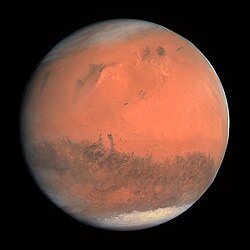
Mars as seen by Rosetta in 2007

The climate of the planet Mars has been an issue of scientific curiosity for centuries, in part because it is the only terrestrial planet whose surface can be directly observed in detail from the Earth with help from a telescope.

Although Mars is smaller than the Earth, at 11% of Earth's mass, and 50% farther from the Sun than the Earth, its climate has important similarities, such as the polar ice caps, seasonal changes and the observable presence of weather patterns. It has attracted sustained study from planetologists and climatologists. While Mars's climate has similarities to Earth's, including periodic ice ages, there are also important differences, such as much lower thermal inertia. Mars' atmosphere has a scale height of approximately 11 km (36,000 ft), 60% greater than that on Earth. The climate is of considerable relevance to the question of whether life is or was present on the planet. The climate briefly received more interest in the news due to NASA measurements indicating increased sublimation of one near-polar region leading to some popular press speculation that Mars was undergoing a parallel bout of global warming,[1] although Mars' average temperature has actually cooled in recent decades, and the polar caps themselves are growing.

Mars has been studied by Earth-based instruments since the 17th century but it is only since the exploration of Mars began in the mid-1960s that close-range observation has been possible. Flyby and orbital spacecraft have provided data from above, while landers and rovers have measured atmospheric conditions directly. Advanced Earth orbital instruments today continue to provide some useful "big picture" observations of relatively large weather phenomena.

The first Martian flyby mission was Mariner 4 which arrived in 1965. That quick two-day pass (July 14–15, 1965) with crude instruments contributed little to the state of knowledge of Martian climate. Later Mariner missions (Mariner 6, and Mariner 7) filled in some of the gaps in basic climate information. Data-based climate studies started in earnest with the Viking program landers in 1975 and continue with such probes as the Mars Reconnaissance Orbiter.

This observational work has been complemented by a type of scientific computer simulation called the Mars general circulation model.[2] Several different iterations of MGCM have led to an increased understanding of Mars as well as the limits of such models.

Historical climate observations

Giacomo Maraldi determined in 1704 that the southern cap is not centered on the rotational pole of Mars.[3] During the opposition of 1719, Maraldi observed both polar caps and temporal variability in their extent.

William Herschel was the first to deduce the low density of the Martian atmosphere in his 1784 paper entitled On the remarkable appearances at the polar regions on the planet Mars, the inclination of its axis, the position of its poles, and its spheroidal figure; with a few hints relating to its real diameter and atmosphere. When Mars appeared to pass close by two faint stars with no effect on their brightness, Herschel correctly concluded that this meant that there was little atmosphere around Mars to interfere with their light.[3]

Honore Flaugergues 1809 discovery of "yellow clouds" on the surface of Mars is the first known observation of Martian dust storms.[4] Flaugergues also observed in 1813 significant polar ice waning during Martian springtime. His speculation that this meant that Mars was warmer than earth proved inaccurate.

Martian paleoclimatology

There are two dating systems now in use for Martian geological time. One is based on crater density and has three ages: Noachian, Hesperian, and Amazonian. The other is a mineralogical timeline, also having three ages: Phyllocian, Theikian, and Siderikian.

Recent observations and modeling are producing information not only about the present climate and atmospheric conditions on Mars but also about its past. The Noachian-era Martian atmosphere had long been theorized to be carbon dioxide–rich. Recent spectral observations of deposits of clay minerals on Mars and modeling of clay mineral formation conditions[5] have found that there is little to no carbonate present in clay of that era. Clay formation in a carbon dioxide–rich environment is always accompanied by carbonate formation, although the carbonate may later be dissolved by volcanic acidity.

The discovery of water-formed minerals on Mars including hematite and jarosite, by the Opportunity rover and goethite by the Spirit rover, has led to the conclusion that climatic conditions in the distant past allowed for free-flowing water on Mars. The morphology of some crater impacts on Mars indicate that the ground was wet at the time of impact.[6] Geomorphic observations of both landscape erosion rates[7] and Martian valley networks[8] also strongly imply warmer, wetter conditions on Noachian-era Mars (earlier than about 4 billion years ago). However, chemical analysis of Martian meteorite samples suggests that the ambient near-surface temperature of Mars has most likely been below 0 °C for the last four billion years.[9]

Some scientists maintain that the great mass of the Tharsis volcanoes has had a major influence on Mars's climate. Erupting volcanoes give off great amounts of gas, mainly water vapor and CO2. Enough gas may have been released by volcanoes to have made the earlier Martian atmosphere thicker than Earth's. The volcanoes could also have emitted enough H2O to cover the whole Martian surface to a depth of 120 m (390 ft). CO2 is a greenhouse gas that raises the temperature of a planet: it traps heat by absorbing infrared radiation. So Tharsis volcanoes, by giving off CO2, could have made Mars more Earth-like in the past. Mars may have once had a much thicker and warmer atmosphere, and oceans and/or lakes may have been present.[10] It has, however, proven extremely difficult to construct convincing global climate models for Mars which produce temperatures above 0 °C at any point in its history,[11] although this may simply reflect problems in accurately calibrating such models.

Weather

Martian morning clouds – Viking Orbiter 1 (taken in 1976)

Mars' temperature and circulation vary every Martian year (as expected for any planet with an atmosphere). Mars lacks oceans, a source of much inter-annual variation on Earth.[clarification needed] Mars Orbiter Camera data beginning in March 1999 and covering 2.5 Martian years[12] show that Martian weather tends to be more repeatable and hence more predictable than that of Earth. If an event occurs at a particular time of year in one year, the available data (sparse as it is) indicate that it is fairly likely to repeat the next year at nearly the same location, give or take a week.

On September 29, 2008, the Phoenix lander took pictures of snow falling from clouds 4.5 km above its landing site near Heimdal Crater. The precipitation vaporized before reaching the ground, a phenomenon called virga.[13]

Clouds

Animation of ice clouds moving above the Phoenix landing site over a period of ten minutes (August 29, 2008).

Mars' dust storms can kick up fine particles in the atmosphere around which clouds can form. These clouds can form very high up, up to 100 km (62 mi) above the planet.[14] The clouds are very faint and can only be seen reflecting sunlight against the darkness of the night sky. In that respect, they look similar to the mesospheric clouds, also known as noctilucent clouds on Earth, which occur about 80 km (50 mi) above our planet.

Temperature

Measurements of Martian temperature predate the Space Age. However, early instrumentation and techniques of radio astronomy produced crude, differing results.[15][16] Early flyby probes (Mariner 4) and later orbiters used radio occultation to perform aeronomy. With chemical composition already deduced from spectroscopy, temperature and pressure could then be derived. Nevertheless, flyby occultations can only measure properties along two transects, at their trajectories' entries and exits from Mars' disk as seen from Earth. This results in weather "snapshots" at a particular area, at a particular time. Orbiters then increase the number of radio transects. Later missions, starting with the dual Mariner 6 and 7 flybys, plus the Soviet Mars 2 and 3, carried infrared detectors to measure radiant energy. Mariner 9 was the first to place an infrared radiometer and spectrometer in Mars orbit in 1971, along with its other instruments and radio transmitter. Viking 1 and 2 followed, with not merely Infrared Thermal Mappers (IRTM).[17] The missions could also corroborate these remote sensing datasets with not only their in situ lander metrology booms,[18] but with higher-altitude temperature and pressure sensors for their descent.[19]

Differing in situ values have been reported for the average temperature on Mars,[20] with a common value being −55 °C (218 K; −67 °F).[21] Surface temperatures may reach a high of about 20 °C (293 K; 68 °F) at noon, at the equator, and a low of about −153 °C (120 K; −243 °F) at the poles.[22] Actual temperature measurements at the Viking landers' site range from −17.2 °C (256.0 K; 1.0 °F) to −107 °C (166 K; −161 °F). The warmest soil temperature estimated by the Viking Orbiter was 27 °C (300 K; 81 °F).[23] The Spirit rover recorded a maximum daytime air temperature in the shade of 35 °C (308 K; 95 °F), and regularly recorded temperatures well above 0 °C (273 K; 32 °F), except in winter.[24]

It has been reported that "On the basis of the nightime air temperature data, every northern spring and early northern summer yet observed were identical to within the level of experimental error (to within ±1 °C)" but that the "daytime data, however, suggest a somewhat different story, with temperatures varying from year-to-year by up to 6 °C in this season.[25] This day-night discrepancy is unexpected and not understood". In southern spring and summer, variance is dominated by dust storms which increase the value of the night low temperature and decrease the daytime peak temperature.[26] This results in a small (20 °C) decrease in average surface temperature, and a moderate (30 °C) increase in upper atmosphere temperature.[27]

Before and after the Viking missions, newer, more advanced Martian temperatures were determined from Earth via microwave spectroscopy. As the microwave beam, of under 1 arcminute, is larger than the disk of the planet, the results are global averages.[28] Later, the Mars Global Surveyor's Thermal Emission Spectrometer and to a lesser extent 2001 Mars Odyssey's THEMIS could not merely reproduce infrared measurements but intercompare lander, rover, and Earth microwave data. The Mars Reconnaissance Orbiter's Mars Climate Sounder can similarly derive atmospheric profiles. The datasets "suggest generally colder atmospheric temperatures and lower dust loading in recent decades on Mars than during the Viking Mission,"[29] although Viking data had previously been revised downward.[30] The TES data indicates "Much colder (10–20 K) global atmospheric temperatures were observed during the 1997 versus 1977 perihelion periods" and "that the global aphelion atmosphere of Mars is colder, less dusty, and cloudier than indicated by the established Viking climatology," again, taking into account the Wilson and Richardson revisions to Viking data.[31]

A later comparison, while admitting "it is the microwave record of air temperatures which is the most representative," attempted to merge the discontinuous spacecraft record. No measurable trend in global average temperature between Viking IRTM and MGS TES was visible. "Viking and MGS air temperatures are essentially indistinguishable for this period, suggesting that the Viking and MGS eras are characterized by essentially the same climatic state." It found "a strong dichotomy" between the northern and southern hemispheres, a "very asymmetric paradigm for the Martian annual cycle: a northern spring and summer which is relatively cool, not very dusty, and relatively rich in water vapor and ice clouds; and a southern summer rather similar to that observed by Viking with warmer air temperatures, less water vapor and water ice, and higher levels of atmospheric dust."[25]

The Mars Reconnaissance Orbiter MCS (Mars Climate Sounder) instrument was, upon arrival, able to operate jointly with MGS for a brief period; the less-capable Mars Odyssey THEMIS and Mars Express SPICAM datasets may also be used to span a single, well-calibrated record. While MCS and TES temperatures are generally consistent,[32] investigators report possible cooling below the analytical precision. "After accounting for this modeled cooling, MCS MY 28 temperatures are an average of 0.9 (daytime) and 1.7 K (night-time) cooler than TES MY 24 measurements."[33]

It has been suggested that Mars had a much thicker, warmer atmosphere early in its history.[34] Much of this early atmosphere would have consisted of carbon dioxide. Such an atmosphere would have raised the temperature, at least in some places, to above the freezing point of water.[35] With the higher temperature running water could have carved out the many channels and outflow valleys that are common on the planet. It also may have gathered together to form lakes and maybe an ocean.[36] Some researchers have suggested that the atmosphere of Mars may have been many times as thick as the Earth's; however research published in September 2015 advanced the idea that perhaps the early Martian atmosphere was not as thick as previously thought.[37]

Currently, the atmosphere is very thin. For many years, it was assumed that as with the Earth, most of the early carbon dioxide was locked up in minerals, called carbonates. However, despite the use of many orbiting instruments that looked for carbonates, very few carbonate deposits have been found.[37][38] Today, it is thought that much of the carbon dioxide in the Martian air was removed by the solar wind. Researchers have discovered a two-step process that sends the gas into space.[39] Ultraviolet light from the Sun could strike a carbon dioxide molecule, breaking it into carbon monoxide and oxygen. A second photon of ultraviolet light could subsequently break the carbon monoxide into oxygen and carbon which would get enough energy to escape the planet. In this process the light isotope of carbon (C
12
) would be most likely to leave the atmosphere. Hence, the carbon dioxide left in the atmosphere would be enriched with the heavy isotope (C
13
).[40] This higher level of the heavy isotope is what was recently found by the Curiosity rover that sits on the surface of Mars.[41][42][43]

Atmospheric properties and processes

Low atmospheric pressure

The Martian atmosphere is composed mainly of carbon dioxide and has a mean surface pressure of about 600 pascals (Pa), much lower than the Earth's 101,000 Pa. One effect of this is that Mars' atmosphere can react much more quickly to a given energy input than that of Earth's atmosphere.[48] As a consequence, Mars is subject to strong thermal tides produced by solar heating rather than a gravitational influence. These tides can be significant, being up to 10% of the total atmospheric pressure (typically about 50 Pa). Earth's atmosphere experiences similar diurnal and semidiurnal tides but their effect is less noticeable because of Earth's much greater atmospheric mass.

Although the temperature on Mars can reach above freezing (0 °C (273 K; 32 °F)), liquid water is unstable over much of the planet, as the atmospheric pressure is below water's triple point and water ice sublimes into water vapor. Exceptions to this are the low-lying areas of the planet, most notably in the Hellas Planitia impact basin, the largest such crater on Mars. It is so deep that the atmospheric pressure at the bottom reaches 1155 Pa, which is above the triple point, so if the temperature exceeded 0 °C liquid water could exist there.[citation needed]

Wind

Curiosity rover's parachute flapping in the Martian wind (HiRISE/MRO) (August 12, 2012 to January 13, 2013).

The surface of Mars has a very low thermal inertia, which means it heats quickly when the sun shines on it. Typical daily temperature swings, away from the polar regions, are around 100 K. On Earth, winds often develop in areas where thermal inertia changes suddenly, such as from sea to land. There are no seas on Mars, but there are areas where the thermal inertia of the soil changes, leading to morning and evening winds akin to the sea breezes on Earth.[49] The Antares project "Mars Small-Scale Weather" (MSW) has recently identified some minor weaknesses in current global climate models (GCMs) due to the GCMs' more primitive soil modeling "heat admission to the ground and back is quite important in Mars, so soil schemes have to be quite accurate. "[50] Those weaknesses are being corrected and should lead to more accurate future assessments, but make continued reliance on older predictions of modeled Martian climate somewhat problematic.


At low latitudes the Hadley circulation dominates, and is essentially the same as the process which on Earth generates the trade winds. At higher latitudes a series of high and low pressure areas, called baroclinic pressure waves, dominate the weather. Mars is drier and colder than Earth, and in consequence dust raised by these winds tends to remain in the atmosphere longer than on Earth as there is no precipitation to wash it out (excepting CO2 snowfall).[51] One such cyclonic storm was recently captured by the Hubble space telescope (pictured below).

One of the major differences between Mars' and Earth's Hadley circulations is their speed[52] which is measured on an overturning timescale. The overturning timescale on Mars is about 100 Martian days while on Earth, it is over a year.

Effect of dust storms

2001 Hellas Basin dust storm
 
Time-lapse composite of Martian horizon over 30 Martian days shows how much sunlight the July 2007 dust storms blocked; Tau of 4.7 indicates 99% blocked.
 
Dust Storm on Mars.
November 18, 2012
November 25, 2012
Locations of Opportunity and Curiosity rovers are noted (MRO).

When the Mariner 9 probe arrived at Mars in 1971, the world expected to see crisp new pictures of surface detail. Instead they saw a near planet-wide dust storm[53] with only the giant volcano Olympus Mons showing above the haze. The storm lasted for a month, an occurrence scientists have since learned is quite common on Mars. Using data from Mariner 9, James B. Pollack et al. proposed a mechanism for Mars dust storms in 1973.[54]

As observed by the Viking spacecraft from the surface,[26] "during a global dust storm the diurnal temperature range narrowed sharply, from 50° Celsius to only about ten degrees, and the wind speeds picked up considerably—indeed, within only an hour of the storm's arrival they had increased to 17 m/s (61 km/h), with gusts up to 26 m/s (94 km/h). Nevertheless, no actual transport of material was observed at either site, only a gradual brightening and loss of contrast of the surface material as dust settled onto it." On June 26, 2001, the Hubble Space Telescope spotted a dust storm brewing in Hellas Basin on Mars (pictured right). A day later the storm "exploded" and became a global event. Orbital measurements showed that this dust storm reduced the average temperature of the surface and raised the temperature of the atmosphere of Mars by 30 K.[27] The low density of the Martian atmosphere means that winds of 18 to 22 m/s (65 to 79 km/h) are needed to lift dust from the surface, but since Mars is so dry, the dust can stay in the atmosphere far longer than on Earth, where it is soon washed out by rain. The season following that dust storm had daytime temperatures 4 K below average. This was attributed to the global covering of light-colored dust that settled out of the dust storm, temporarily increasing Mars' albedo.[55]

In mid-2007 a planet-wide dust storm posed a serious threat to the solar-powered Spirit and Opportunity Mars Exploration Rovers by reducing the amount of energy provided by the solar panels and necessitating the shut-down of most science experiments while waiting for the storms to clear.[56] Following the dust storms, the rovers had significantly reduced power due to settling of dust on the arrays.

Mars without a dust storm on June 2001 (on left) and with a global dust storm on July 2001 (on right), as seen by Mars Global Surveyor

Dust storms are most common during perihelion, when the planet receives 40 percent more sunlight than during aphelion. During aphelion water ice clouds form in the atmosphere, interacting with the dust particles and affecting the temperature of the planet.[57]

It has been suggested that dust storms on Mars could play a role in storm formation similar to that of water clouds on Earth.[citation needed] Observation since the 1950s has shown that the chances of a planet-wide dust storm in a particular Martian year are approximately one in three.[58]

Dust storms contribute to water loss on Mars. A study of dust storms with the Mars Reconnaissance Orbiter suggested that 10 percent of the water loss from Mars may have been caused by dust storms. Instruments on board the Mars Reconnaissance Orbiter detected observed water vapor at very high altitudes during global dust storms. Ultraviolet light from the sun can then break the water apart into hydrogen and oxygen. The Hydrogen from the water molecule then escapes into space.[59] [60] [61]

Saltation

The process of geological saltation is quite important on Mars as a mechanism for adding particulates to the atmosphere. Saltating sand particles have been observed on the MER Spirit rover.[62] Theory and real world observations have not agreed with each other, classical theory missing up to half of real-world saltating particles.[63] A new model more closely in accord with real world observations demonstrates that saltating particles create an electrical field that increases the saltation effect. Mars grains saltate in 100 times higher and longer trajectories and reach 5–10 times higher velocities than Earth grains do.[64]

Repeating northern annular cloud

Hubble view of the colossal polar cloud on Mars

A large doughnut shaped cloud appears in North polar region of Mars around the same time every Martian year and of about the same size.[65] It forms in the morning and dissipates by the Martian afternoon.[65] The outer diameter of the cloud is roughly 1,600 km (1,000 mi), and the inner hole or eye is 320 km (200 mi) across.[66] The cloud is thought to be composed of water-ice,[66] so it is white in color, unlike the more common dust storms.

It looks like a cyclonic storm, similar to a hurricane, but it does not rotate.[65] The cloud appears during the northern summer and at high latitude. Speculation is that this is due to unique climate conditions near the northern pole.[66] Cyclone-like storms were first detected during the Viking orbital mapping program, but the northern annular cloud is nearly three times larger.[66] The cloud has also been detected by various probes and telescopes including the Hubble and Mars Global Surveyor.[65][66]

Other repeating events are dust storms and dust devils.[66]

Methane presence

Methane map

Although methane is a greenhouse gas on Earth, the small amounts that have been claimed to be present on Mars would have little effect on the Martian global climate. Trace amounts of methane (CH4) at concentration of several parts per billion (ppb), were first reported in the atmosphere of Mars by a team at the NASA Goddard Space Flight Center in 2003.[67][68]

In March 2004 the Mars Express Orbiter[69][70][71][72] and ground-based observations from Canada-France-Hawaii Telescope[73] also suggested the presence of methane in the atmosphere with a mole fraction of about 10 nmol/mol.[74] However, the complexity of these observations has sparked discussion as to the reliability of the results.[75]

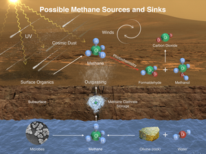
Methane (CH4) on Mars – potential sources and sinks.

Since breakup of that much methane by ultraviolet light would only take 350 years under current Martian conditions, if methane is present some sort of active source must be replenishing the gas.[76]
Clathrate hydrates,[77] or water-rock reactions[78] could be possible geological sources of methane but there is presently no consensus on the source or existence of Martian methane.

The Curiosity rover landed on Mars in August 2012. It is able to make precise abundance measurements and also distinguish between different isotopologues of methane.[79] The first measurements with the Tunable Laser Spectrometer (TLS) indicate that there is less than 5 ppb of methane at the landing site.[80][81][82][83] On September 19, 2013 NASA scientists used further measurements from Curiosity to report a non-detection of atmospheric methane with a measured value of 0.18±0.67 ppbv corresponding to an upper limit of 1.3 ppbv (95% confidence limit).[84]

On 16 December 2014, NASA reported the Curiosity rover detected a "tenfold spike", likely localized, in the amount of methane in the Martian atmosphere. Sample measurements taken "a dozen times over 20 months" showed increases in late 2013 and early 2014, averaging "7 parts of methane per billion in the atmosphere." Before and after that, readings averaged around one-tenth that level.[85][86]

The Indian Mars Orbiter Mission, launched in November 5, 2013, will attempt to detect and map the sources of methane, if they exist.[87] The ExoMars Trace Gas Orbiter planned to launch in 2016 would further study the methane,[88][89] as well as its decomposition products such as formaldehyde and methanol.

Carbon dioxide carving

Mars Reconnaissance Orbiter images suggest an unusual erosion effect occurs based on Mars' unique climate. Spring warming in certain areas leads to CO2 ice subliming and flowing upwards, creating highly unusual erosion patterns called "spider gullies".[90] Translucent CO2 ice forms over winter and as the spring sunlight warms the surface, it vaporizes the CO2 to gas which flows uphill under the translucent CO2 ice. Weak points in that ice lead to CO2 geysers.[90]

Mountains

Planet Marsvolatile gases – (Curiosity rover, October 2012).

Martian storms are significantly affected by Mars' large mountain ranges.[91] Individual mountains like record holding Olympus Mons (26 km (85,000 ft)) can affect local weather but larger weather effects are due to the larger collection of volcanoes in the Tharsis region.

One unique repeated weather phenomenon involving Mountains is a spiral dust cloud that forms over Arsia Mons. The spiral dust cloud over Arsia Mons can tower 15 to 30 km (49,000 to 98,000 ft) above the volcano.[92] Clouds are present around Arsia Mons throughout the Martian year, peaking in late summer.[93]

Clouds surrounding mountains display a seasonal variability. Clouds at Olympus Mons and Ascreaus Mons appear in northern hemisphere spring and summer, reaching a total maximum area of approximately 900,000 km2 and 1,000,000 km2 respectively in late spring. Clouds around Alba Patera and Pavonis Mons show an additional, smaller peak in late summer. Very few clouds were observed in winter. Predictions from the Mars General Circulation Model are consistent with these observations.[93]

Polar caps

How Mars might have looked during an ice age between 2.1 million and 400,000 years ago, when Mars's axial tilt is thought to have been larger than today.
 
HiRISE view of Olympia Rupes in Planum Boreum, one of many exposed water ice layers found in the polar regions of Mars. Depicted width: 1.3 km (0.8 miles)
 
HiRISE image of "dark dune spots" and fans formed by eruptions of CO2 gas geysers on Mars' south polar ice sheet.

Mars has ice caps at its north pole and south pole, which mainly consist of water ice; however, there is frozen carbon dioxide (dry ice) present on their surfaces. Dry ice accumulates in the north polar region (Planum Boreum) in winter only, subliming completely in summer, while the south polar region additionally has a permanent dry ice cover up to eight meters (25 feet) thick.[94] This difference is due to the higher elevation of the south pole.

So much of the atmosphere can condense at the winter pole that the atmospheric pressure can vary by up to a third of its mean value. This condensation and evaporation will cause the proportion of the noncondensable gases in the atmosphere to change inversely.[51] The eccentricity of Mars's orbit affects this cycle, as well as other factors. In the spring and autumn wind due to the carbon dioxide sublimation process is so strong that it can be a cause of the global dust storms mentioned above.[95]

The northern polar cap has a diameter of approximately 1,000 km during the northern Mars summer,[96] and contains about 1.6 million cubic kilometres of ice, which if spread evenly on the cap would be 2 km thick.[97] (This compares to a volume of 2.85 million cubic kilometres for the Greenland ice sheet.) The southern polar cap has a diameter of 350 km and a maximum thickness of 3 km.[98] Both polar caps show spiral troughs, were initially thought to form as a result of differential solar heating, coupled with the sublimation of ice and condensation of water vapor.[99][100] Recent analysis of ice penetrating radar data from SHARAD has demonstrated that the spiral troughs are formed from a unique situation in which high density katabatic winds descend from the polar high to transport ice and create large wavelength bedforms.[101][102] The spiral shape comes from Coriolis effect forcing of the winds, much like winds on earth spiral to form a hurricane. The troughs did not form with either ice cap, instead they began to form between 2.4 million and 500,000 years ago, after three fourths of the ice cap was in place. This suggests that a climatic shift allowed for their onset. Both polar caps shrink and regrow following the temperature fluctuation of the Martian seasons; there are also longer-term trends that are better understood in the modern era.

During the southern hemisphere spring, solar heating of dry ice deposits at the south pole leads in places to accumulation of pressurized CO2 gas below the surface of the semitransparent ice, warmed by absorption of radiation by the darker substrate. After attaining the necessary pressure, the gas bursts through the ice in geyser-like plumes. While the eruptions have not been directly observed, they leave evidence in the form of "dark dune spots" and lighter fans atop the ice, representing sand and dust carried aloft by the eruptions, and a spider-like pattern of grooves created below the ice by the outrushing gas.[103][104] (see Geysers on Mars.) Eruptions of nitrogen gas observed by Voyager 2 on Triton are thought to occur by a similar mechanism.

Both polar caps are currently accumulating, confirming predicted Milankovich cycling on timescales of ~400,000 and ~4,000,000 years. Soundings by the Mars Reconnaissance Orbiter SHARAD indicate total cap growth of ~0.24 km3/year. Of this, 92%, or ~0.86 mm/year, is going to the north,[105] as Mars' offset Hadley circulation acts as a nonlinear pump of volatiles northward.

Solar wind

Mars lost most of its magnetic field about four billion years ago. As a result, solar wind and cosmic radiation interacts directly with the Martian ionosphere. This keeps the atmosphere thinner than it would otherwise be by solar wind action constantly stripping away atoms from the outer atmospheric layer.[106] Most of the historical atmospheric loss on Mars can be traced back to this solar wind effect. Current theory posits a weakening solar wind and thus today's atmosphere stripping effects are much less than those in the past when the solar wind was stronger.[citation needed]

Seasons

In spring, sublimation of ice causes sand from below the ice layer to form fan-shaped deposits on top of the seasonal ice.

Mars has an axial tilt of 25.2°. This means that there are seasons on Mars, just as on Earth. The eccentricity of Mars' orbit is 0.1, much greater than the Earth's present orbital eccentricity of about 0.02. The large eccentricity causes the insolation on Mars to vary as the planet orbits the Sun. (The Martian year lasts 687 days, roughly 2 Earth years.) As on Earth, Mars' obliquity dominates the seasons but, because of the large eccentricity, winters in the southern hemisphere are long and cold while those in the North are short and warm.

It is now thought that ice accumulated when Mars' orbital tilt was very different from what it is now. (The axis the planet spins on has considerable "wobble," meaning its angle changes over time.)[107][108][109] A few million years ago, the tilt of the axis of Mars was 45 degrees instead of its present 25 degrees. Its tilt, also called obliquity, varies greatly because its two tiny moons cannot stabilize it like our moon.

Many features on Mars, especially in the Ismenius Lacus quadrangle, are thought to contain large amounts of ice. The most popular model for the origin of the ice is climate change from large changes in the tilt of the planet's rotational axis. At times the tilt has even been greater than 80 degrees[110][111] Large changes in the tilt explains many ice-rich features on Mars.

Studies have shown that when the tilt of Mars reaches 45 degrees from its current 25 degrees, ice is no longer stable at the poles.[112] Furthermore, at this high tilt, stores of solid carbon dioxide (dry ice) sublimate, thereby increasing the atmospheric pressure. This increased pressure allows more dust to be held in the atmosphere. Moisture in the atmosphere will fall as snow or as ice frozen onto dust grains. Calculations suggest this material will concentrate in the mid-latitudes.[113][114] General circulation models of the Martian atmosphere predict accumulations of ice-rich dust in the same areas where ice-rich features are found.[111] When the tilt begins to return to lower values, the ice sublimates (turns directly to a gas) and leaves behind a lag of dust.[115][115][116] The lag deposit caps the underlying material so with each cycle of high tilt levels, some ice-rich mantle remains behind.[117] Note, that the smooth surface mantle layer probably represents only relative recent material. Below are images of layers in this smooth mantle that drops from the sky at times.
The seasons present unequal lengths are as follows:

Season Sols
(on Mars)
Days
(on Earth)
Northern Spring, Southern Autumn: 193.30 92.764
Northern Summer, Southern Winter: 178.64 93.647
Northern Autumn, Southern Spring: 142.70 89.836
Northern Winter, Southern Summer: 153.95 88.997

Precession in the alignment of the obliquity and eccentricity lead to global warming and cooling ('great' summers and winters) with a period of 170,000 years.[118]

Like Earth, the obliquity of Mars undergoes periodic changes which can lead to long-lasting changes in climate. Once again, the effect is more pronounced on Mars because it lacks the stabilizing influence of a large moon. As a result, the obliquity can alter by as much as 45°. Jacques Laskar, of France's National Centre for Scientific Research, argues that the effects of these periodic climate changes can be seen in the layered nature of the ice cap at the Martian north pole.[119] Current research suggests that Mars is in a warm interglacial period which has lasted more than 100,000 years.[120]

Because the Mars Global Surveyor was able to observe Mars for 4 Martian years, it was found that Martian weather was similar from year to year. Any differences were directly related to changes in the solar energy that reached Mars. Scientists were even able to accurately predict dust storms that would occur during the landing of Beagle 2. Regional dust storms were discovered to be closely related to where dust was available.[121]

Evidence for recent climatic change

Pits in south polar ice cap, MGS 1999, NASA

There have been regional changes around the south pole (Planum Australe) over the past few Martian years. In 1999 the Mars Global Surveyor photographed pits in the layer of frozen carbon dioxide at the Martian south pole. Because of their striking shape and orientation these pits have become known as swiss cheese features. In 2001 the craft photographed the same pits again and found that they had grown larger, retreating about 3 meters in one Martian year.[122] These features are caused by the sublimation of the dry ice layer, thereby exposing the inert water ice layer. More recent observations indicate that the ice at Mars' south pole is continuing to sublimate.[123] The pits in the ice continue to grow by about 3 meters per Martian year. Malin states that conditions on Mars are not currently conducive to the formation of new ice. A NASA press release indicates that "climate change [is] in progress"[124] on Mars. In a summary of observations with the Mars Orbiter Camera, researchers speculated that some dry ice may have been deposited between the Mariner 9 and the Mars Global Surveyor mission. Based on the current rate of loss, the deposits of today may be gone in a hundred years.[121]

Elsewhere on the planet, low latitude areas have more water ice than they should have given current climatic conditions.[125][126][127] Mars Odyssey "is giving us indications of recent global climate change in Mars," said Jeffrey Plaut, project scientist for the mission at NASA's Jet Propulsion Laboratory, in non-peer reviewed published work in 2003.

Attribution theories

Polar changes

Colaprete et al. conducted simulations with the Mars General Circulation Model which show that the local climate around the Martian south pole may currently be in an unstable period. The simulated instability is rooted in the geography of the region, leading the authors to speculate that the sublimation of the polar ice is a local phenomenon rather than a global one.[128] The researchers showed that even with a constant solar luminosity the poles were capable of jumping between states of depositing or losing ice. The trigger for a change of states could be either increased dust loading in the atmosphere or an albedo change due to deposition of water ice on the polar cap.[129] This theory is somewhat problematic due to the lack of ice depositation after the 2001 global dust storm.[55] Another issue is that the accuracy of the Mars General Circulation Model decreases as the scale of the phenomenon becomes more local.

It has been argued that "observed regional changes in south polar ice cover are almost certainly due to a regional climate transition, not a global phenomenon, and are demonstrably unrelated to external forcing."[118] Writing in a Nature news story, Chief News and Features Editor Oliver Morton said "The warming of other solar bodies has been seized upon by climate sceptics. On Mars, the warming seems to be down to dust blowing around and uncovering big patches of black basaltic rock that heat up in the day."[55][130]

Solar irradiance

K. I. Abdusamatov has proposed that "parallel global warmings" observed simultaneously on Mars and on Earth can only be a consequence of the same factor: a long-time change in solar irradiance."[131] While some individuals who reject the science of global warming take this as proof that humans are not causing climate change,[132] Abdusamatov's hypothesis has not been accepted by the scientific community. His assertions have not been published in the peer-reviewed literature, and have been dismissed by other scientists, who have stated that "the idea just isn't supported by the theory or by the observations" and that it "doesn't make physical sense."[133] Other scientists have proposed that the observed variations are caused by irregularities in the orbit of Mars or a possible combination of solar and orbital effects.[134]

Mars Global Climate Zones, based on temperature, modified by topography, albedo, actual solar radiation.
Climate zones

Terrestrial Climate zones first have been defined by Wladimir Köppen based on the distribution of vegetation groups. Climate classification is furthermore based on temperature, rainfall, and subdivided based upon differences in the seasonal distribution of temperature and precipitation; and a separate group exists for extrazonal climates like in high altitudes. Mars has neither vegetation nor rainfall, so any climate classification could be only based upon temperature; a further refinement of the system may be based on dust distribution, water vapor content, occurrence of snow. Solar Climate Zones can also be easily defined for Mars.[135]

Current missions

The 2001 Mars Odyssey is currently orbiting Mars and taking global atmospheric temperature measurements with the TES instrument. The Mars Reconnaissance Orbiter is currently taking daily weather and climate related observations from orbit. One of its instruments, the Mars climate sounder is specialized for climate observation work. The MSL was launched in November 2011 and landed on Mars on August 6, 2012.[136] Orbiters MAVEN, Mangalyaan, and TGO are currently orbiting Mars and studying its atmosphere.

Mercury (planet)

From Wikipedia, the free encyclopedia
Mercury Astronomical symbol of Mercury
Mercury in color - Prockter07-edit1.jpg
Mercury in enhanced color, imaged by MESSENGER (2008)
Designations
Pronunciation /ˈmɜːrkjəri/ (About this sound listen)
Adjectives Mercurian,[1] mercurial[2]
Orbital characteristics[5]
Epoch J2000
Aphelion
  • 0.466 697 AU
  • 69,816,900 km
Perihelion
  • 0.307 499 AU
  • 46,001,200 km
  • 0.387 098 AU
  • 57,909,050 km
Eccentricity 0.205 630[3]
115.88 d[3]
Average orbital speed
47.362 km/s[3]
174.796°
Inclination
48.331°
29.124°
Satellites None
Physical characteristics
Mean radius
  • 2,439.7±1.0 km[6][7]
  • 0.3829 Earths
Flattening 0[7]
  • 7.48×10⁷ km2[6]
  • 0.147 Earths
Volume
  • 6.083×10¹⁰ km3[6]
  • 0.056 Earths
Mass
  • 3.3011×10²³ kg[8]
  • 0.055 Earths
Mean density
5.427 g/cm3[6]
  • 3.7 m/s2
  • 0.38 g[6]
0.346±0.014[9]
4.25 km/s[6]
Sidereal rotation period
  • 58.646 d
  • 1407.5 h[6]
Equatorial rotation velocity
10.892 km/h (3.026 m/s)
2.04′ ± 0.08′ (to orbit)[9]
(0.034°)[3]
North pole right ascension
  • 18h 44m 2s
  • 281.01°[3]
North pole declination
61.45°[3]
Albedo
Surface temp. min mean max
0°N, 0°W [11] 100 K 340 K 700 K
85°N, 0°W[11] 80 K 200 K 380 K
−2.6[12] to 5.7[3][13]
4.5–13″[3]
Atmosphere[14]
Surface pressure
trace (≲ 0.5 nPa)
Composition by volume
Mercury is the smallest and innermost planet in the Solar System. Its orbital period around the Sun of 87.97 days is the shortest of all the planets in the Solar System. It is named after the Roman deity Mercury, the messenger of the gods.

Like Venus, Mercury orbits the Sun within Earth's orbit as an inferior planet, and never exceeds 28° away from the Sun. When viewed from Earth, this proximity to the Sun means the planet can only be seen near the western or eastern horizon during the early evening or early morning. At this time it may appear as a bright star-like object, but is often far more difficult to observe than Venus. The planet telescopically displays the complete range of phases, similar to Venus and the Moon, as it moves in its inner orbit relative to Earth, which reoccurs over the so-called synodic period approximately every 116 days.

Mercury is gravitationally locked with the Sun in a 3:2 spin-orbit resonance,[15] and rotates in a way that is unique in the Solar System. As seen relative to the fixed stars, it rotates on its axis exactly three times for every two revolutions it makes around the Sun.[a][16] As seen from the Sun, in a frame of reference that rotates with the orbital motion, it appears to rotate only once every two Mercurian years. An observer on Mercury would therefore see only one day every two years.

Mercury's axis has the smallest tilt of any of the Solar System's planets (about ​130 degree). Its orbital eccentricity is the largest of all known planets in the Solar System;[b] at perihelion, Mercury's distance from the Sun is only about two-thirds (or 66%) of its distance at aphelion. Mercury's surface appears heavily cratered and is similar in appearance to the Moon's, indicating that it has been geologically inactive for billions of years. Having almost no atmosphere to retain heat, it has surface temperatures that vary diurnally more than on any other planet in the Solar System, ranging from 100 K (−173 °C; −280 °F) at night to 700 K (427 °C; 800 °F) during the day across the equatorial regions. The polar regions are constantly below 180 K (−93 °C; −136 °F). The planet has no known natural satellites.

Two spacecraft have visited Mercury: Mariner 10 flew by in 1974 and 1975; and MESSENGER, launched in 2004, orbited Mercury over 4,000 times in four years before exhausting its fuel and crashing into the planet's surface on April 30, 2015.[17][18][19]

Physical characteristics

Internal structure

Internal structure of Mercury:
  1. Crust: 100–300 km thick
  2. Mantle: 600 km thick
  3. Core: 1,800 km radius
Gravity anomalies on Mercury—mass concentrations (red) suggest subsurface structure and evolution

Mercury appears to have a solid silicate crust and mantle overlying a solid, iron sulfide outer core layer, a deeper liquid core layer, and possibly a solid inner core.[20]

Mercury is one of four terrestrial planets in the Solar System, and is a rocky body like Earth. It is the smallest planet in the Solar System, with an equatorial radius of 2,439.7 kilometres (1,516.0 mi).[3] Mercury is also smaller—albeit more massive—than the largest natural satellites in the Solar System, Ganymede and Titan. Mercury consists of approximately 70% metallic and 30% silicate material.[21] Mercury's density is the second highest in the Solar System at 5.427 g/cm3, only slightly less than Earth's density of 5.515 g/cm3.[3] If the effect of gravitational compression were to be factored out from both planets, the materials of which Mercury is made would be denser than those of Earth, with an uncompressed density of 5.3 g/cm3 versus Earth's 4.4 g/cm3.[22]

Mercury's density can be used to infer details of its inner structure. Although Earth's high density results appreciably from gravitational compression, particularly at the core, Mercury is much smaller and its inner regions are not as compressed. Therefore, for it to have such a high density, its core must be large and rich in iron.[23]

Geologists estimate that Mercury's core occupies about 55% of its volume; for Earth this proportion is 17%. Research published in 2007 suggests that Mercury has a molten core.[24][25] Surrounding the core is a 500–700 km mantle consisting of silicates.[26][27] Based on data from the Mariner 10 mission and Earth-based observation, Mercury's crust is estimated to be 35 km thick.[28] One distinctive feature of Mercury's surface is the presence of numerous narrow ridges, extending up to several hundred kilometers in length. It is thought that these were formed as Mercury's core and mantle cooled and contracted at a time when the crust had already solidified.[29]

Mercury's core has a higher iron content than that of any other major planet in the Solar System, and several theories have been proposed to explain this. The most widely accepted theory is that Mercury originally had a metal–silicate ratio similar to common chondrite meteorites, thought to be typical of the Solar System's rocky matter, and a mass approximately 2.25 times its current mass.[30] Early in the Solar System's history, Mercury may have been struck by a planetesimal of approximately 1/6 that mass and several thousand kilometers across.[30] The impact would have stripped away much of the original crust and mantle, leaving the core behind as a relatively major component.[30] A similar process, known as the giant impact hypothesis, has been proposed to explain the formation of the Moon.[30]

Alternatively, Mercury may have formed from the solar nebula before the Sun's energy output had stabilized. It would initially have had twice its present mass, but as the protosun contracted, temperatures near Mercury could have been between 2,500 and 3,500 K and possibly even as high as 10,000 K.[31] Much of Mercury's surface rock could have been vaporized at such temperatures, forming an atmosphere of "rock vapor" that could have been carried away by the solar wind.[31]

A third hypothesis proposes that the solar nebula caused drag on the particles from which Mercury was accreting, which meant that lighter particles were lost from the accreting material and not gathered by Mercury.[32] Each hypothesis predicts a different surface composition, and there are two space missions set to make observations. MESSENGER, which ended in 2015, found higher-than-expected potassium and sulfur levels on the surface, suggesting that the giant impact hypothesis and vaporization of the crust and mantle did not occur because potassium and sulfur would have been driven off by the extreme heat of these events.[33] BepiColombo, which will arrive at Mercury in 2025, will make observations to test these hypotheses.[34] The findings so far would seem to favor the third hypothesis; however, further analysis of the data is needed.[35]

Surface geology

PIA19420-Mercury-NorthHem-Topography-MLA-Messenger-20150416.jpg
Map of Mercury's northern hemisphere by the MLA instrument on MESSENGER
lowest (purple) to 10 km (6.2 mi) highest (red).
Mercury's surface is similar in appearance to that of the Moon, showing extensive mare-like plains and heavy cratering, indicating that it has been geologically inactive for billions of years. Because knowledge of Mercury's geology had been based only on the 1975 Mariner 10 flyby and terrestrial observations, it is the least understood of the terrestrial planets.[25] As data from MESSENGER orbiter are processed, this knowledge will increase. For example, an unusual crater with radiating troughs has been discovered that scientists called "the spider".[36] It was later named Apollodorus.[37]

Mercury's surface

Albedo features are areas of markedly different reflectivity, as seen by telescopic observation. Mercury has dorsa (also called "wrinkle-ridges"), Moon-like highlands, montes (mountains), planitiae (plains), rupes (escarpments), and valles (valleys).[38][39]

MASCS spectrum scan of Mercury's surface by MESSENGER

Names for features on Mercury come from a variety of sources. Names coming from people are limited to the deceased. Craters are named for artists, musicians, painters, and authors who have made outstanding or fundamental contributions to their field. Ridges, or dorsa, are named for scientists who have contributed to the study of Mercury. Depressions or fossae are named for works of architecture. Montes are named for the word "hot" in a variety of languages. Plains or planitiae are named for Mercury in various languages. Escarpments or rupēs are named for ships of scientific expeditions. Valleys or valles are named for radio telescope facilities.[40]

Mercury was heavily bombarded by comets and asteroids during and shortly following its formation 4.6 billion years ago, as well as during a possibly separate subsequent episode called the Late Heavy Bombardment that ended 3.8 billion years ago.[41] During this period of intense crater formation, Mercury received impacts over its entire surface,[39] facilitated by the lack of any atmosphere to slow impactors down.[42] During this time Mercury was volcanically active; basins such as the Caloris Basin were filled by magma, producing smooth plains similar to the maria found on the Moon.[43][44]

Data from the October 2008 flyby of MESSENGER gave researchers a greater appreciation for the jumbled nature of Mercury's surface. Mercury's surface is more heterogeneous than either Mars's or the Moon's, both of which contain significant stretches of similar geology, such as maria and plateaus.[45]

Impact basins and craters

Perspective view of Caloris Basin – high (red); low (blue).

Craters on Mercury range in diameter from small bowl-shaped cavities to multi-ringed impact basins hundreds of kilometers across. They appear in all states of degradation, from relatively fresh rayed craters to highly degraded crater remnants. Mercurian craters differ subtly from lunar craters in that the area blanketed by their ejecta is much smaller, a consequence of Mercury's stronger surface gravity.[46] According to IAU rules, each new crater must be named after an artist that was famous for more than fifty years, and dead for more than three years, before the date the crater is named.[47]

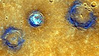
Enhanced-color image of Munch, Sander and Poe craters amid volcanic plains (orange) near Caloris Basin

The largest known crater is Caloris Basin, with a diameter of 1,550 km.[48] The impact that created the Caloris Basin was so powerful that it caused lava eruptions and left a concentric ring over 2 km tall surrounding the impact crater. At the antipode of the Caloris Basin is a large region of unusual, hilly terrain known as the "Weird Terrain". One hypothesis for its origin is that shock waves generated during the Caloris impact traveled around Mercury, converging at the basin's antipode (180 degrees away). The resulting high stresses fractured the surface.[49] Alternatively, it has been suggested that this terrain formed as a result of the convergence of ejecta at this basin's antipode.[50]

Overall, about 15 impact basins have been identified on the imaged part of Mercury. A notable basin is the 400 km wide, multi-ring Tolstoj Basin that has an ejecta blanket extending up to 500 km from its rim and a floor that has been filled by smooth plains materials. Beethoven Basin has a similar-sized ejecta blanket and a 625 km diameter rim.[46] Like the Moon, the surface of Mercury has likely incurred the effects of space weathering processes, including Solar wind and micrometeorite impacts.[51]

Interior of Abedin crater

Plains

Degas crater

There are two geologically distinct plains regions on Mercury.[46][52] Gently rolling, hilly plains in the regions between craters are Mercury's oldest visible surfaces,[46] predating the heavily cratered terrain. These inter-crater plains appear to have obliterated many earlier craters, and show a general paucity of smaller craters below about 30 km in diameter.[52]

The so-called "Weird Terrain" formed at the point antipodal to the Caloris Basin impact

Smooth plains are widespread flat areas that fill depressions of various sizes and bear a strong resemblance to the lunar maria. Notably, they fill a wide ring surrounding the Caloris Basin. Unlike lunar maria, the smooth plains of Mercury have the same albedo as the older inter-crater plains. Despite a lack of unequivocally volcanic characteristics, the localisation and rounded, lobate shape of these plains strongly support volcanic origins.[46] All the smooth plains of Mercury formed significantly later than the Caloris basin, as evidenced by appreciably smaller crater densities than on the Caloris ejecta blanket.[46] The floor of the Caloris Basin is filled by a geologically distinct flat plain, broken up by ridges and fractures in a roughly polygonal pattern. It is not clear whether they are volcanic lavas induced by the impact, or a large sheet of impact melt.[46]

Compressional features

One unusual feature of Mercury's surface is the numerous compression folds, or rupes, that crisscross the plains. As Mercury's interior cooled, it contracted and its surface began to deform, creating wrinkle ridges and lobate scarps associated with thrust faults. The scarps can reach lengths of 1000 km and heights of 3 km.[53] These compressional features can be seen on top of other features, such as craters and smooth plains, indicating they are more recent.[54] Mapping of the features has suggested a total shrinkage of Mercury's radius in the range of ~1 to 7 km.[55] Small-scale thrust fault scarps have been found, tens of meters in height and with lengths in the range of a few km, that appear to be less than 50 million years old, indicating that compression of the interior and consequent surface geological activity continue to the present.[53][55]

The Lunar Reconnaissance Orbiter discovered that similar small thrust faults exist on the Moon.

Volcanology

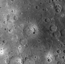
Picasso crater — the large arc-shaped pit located on the eastern side of its floor are postulated to have formed when subsurface magma subsided or drained, causing the surface to collapse into the resulting void.

Images obtained by MESSENGER have revealed evidence for pyroclastic flows on Mercury from low-profile shield volcanoes.[56][57][58] MESSENGER data has helped identify 51 pyroclastic deposits on the surface,[59] where 90% of them are found within impact craters.[59] A study of the degradation state of the impact craters that host pyroclastic deposits suggests that pyroclastic activity occurred on Mercury over a prolonged interval.[59]

A "rimless depression" inside the southwest rim of the Caloris Basin consists of at least nine overlapping volcanic vents, each individually up to 8 km in diameter. It is thus a "compound volcano".[60] The vent floors are at a least 1 km below their brinks and they bear a closer resemblance to volcanic craters sculpted by explosive eruptions or modified by collapse into void spaces created by magma withdrawal back down into a conduit.[60] The scientists could not quantify the age of the volcanic complex system, but reported that it could be of the order of a billion years.[60]

Surface conditions and exosphere

Composite image of Mercury taken by MESSENGER
 
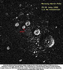
Radar image of Mercury's north pole
 
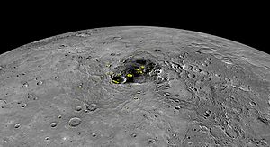
Composite of the north pole of Mercury, where NASA confirmed the discovery of a large volume of water ice, in permanently dark craters that exist there.[61]

The surface temperature of Mercury ranges from 100 K to 700 K[62] at the most extreme places: 0°N, 0°W, or 180°W. It never rises above 180 K at the poles,[11] due to the absence of an atmosphere and a steep temperature gradient between the equator and the poles. The subsolar point reaches about 700 K during perihelion (0°W or 180°W), but only 550 K at aphelion (90° or 270°W).[63] On the dark side of the planet, temperatures average 110 K.[11][64] The intensity of sunlight on Mercury's surface ranges between 4.59 and 10.61 times the solar constant (1,370 W·m−2).[65]

Although the daylight temperature at the surface of Mercury is generally extremely high, observations strongly suggest that ice (frozen water) exists on Mercury. The floors of deep craters at the poles are never exposed to direct sunlight, and temperatures there remain below 102 K; far lower than the global average.[66] Water ice strongly reflects radar, and observations by the 70-meter Goldstone Solar System Radar and the VLA in the early 1990s revealed that there are patches of high radar reflection near the poles.[67] Although ice was not the only possible cause of these reflective regions, astronomers think it was the most likely.[68]

The icy regions are estimated to contain about 1014–1015 kg of ice,[69] and may be covered by a layer of regolith that inhibits sublimation.[70] By comparison, the Antarctic ice sheet on Earth has a mass of about 4×10¹⁸ kg, and Mars's south polar cap contains about 1016 kg of water.[69] The origin of the ice on Mercury is not yet known, but the two most likely sources are from outgassing of water from the planet's interior or deposition by impacts of comets.[69]

Mercury is too small and hot for its gravity to retain any significant atmosphere over long periods of time; it does have a tenuous surface-bounded exosphere[71] containing hydrogen, helium, oxygen, sodium, calcium, potassium and others at a surface pressure of less than approximately 0.5 nPa (0.005 picobars).[14] This exosphere is not stable—atoms are continuously lost and replenished from a variety of sources. Hydrogen atoms and helium atoms probably come from the solar wind, diffusing into Mercury's magnetosphere before later escaping back into space. Radioactive decay of elements within Mercury's crust is another source of helium, as well as sodium and potassium. MESSENGER found high proportions of calcium, helium, hydroxide, magnesium, oxygen, potassium, silicon and sodium. Water vapor is present, released by a combination of processes such as: comets striking its surface, sputtering creating water out of hydrogen from the solar wind and oxygen from rock, and sublimation from reservoirs of water ice in the permanently shadowed polar craters. The detection of high amounts of water-related ions like O+, OH, and H2O+ was a surprise.[72][73] Because of the quantities of these ions that were detected in Mercury's space environment, scientists surmise that these molecules were blasted from the surface or exosphere by the solar wind.[74][75]

Sodium, potassium and calcium were discovered in the atmosphere during the 1980–1990s, and are thought to result primarily from the vaporization of surface rock struck by micrometeorite impacts[76] including presently from Comet Encke.[77] In 2008, magnesium was discovered by MESSENGER.[78] Studies indicate that, at times, sodium emissions are localized at points that correspond to the planet's magnetic poles. This would indicate an interaction between the magnetosphere and the planet's surface.[79]

On November 29, 2012, NASA confirmed that images from MESSENGER had detected that craters at the north pole contained water ice. MESSENGER's principal investigator Sean Solomon is quoted in The New York Times estimating the volume of the ice to be large enough to "encase Washington, D.C., in a frozen block two and a half miles deep".[61][c]

Magnetic field and magnetosphere

Graph showing relative strength of Mercury's magnetic field

Despite its small size and slow 59-day-long rotation, Mercury has a significant, and apparently global, magnetic field. According to measurements taken by Mariner 10, it is about 1.1% the strength of Earth's. The magnetic-field strength at Mercury's equator is about 300 nT.[80][81] Like that of Earth, Mercury's magnetic field is dipolar.[79] Unlike Earth's, Mercury's poles are nearly aligned with the planet's spin axis.[82] Measurements from both the Mariner 10 and MESSENGER space probes have indicated that the strength and shape of the magnetic field are stable.[82]

It is likely that this magnetic field is generated by a dynamo effect, in a manner similar to the magnetic field of Earth.[83][84] This dynamo effect would result from the circulation of the planet's iron-rich liquid core. Particularly strong tidal effects caused by the planet's high orbital eccentricity would serve to keep the core in the liquid state necessary for this dynamo effect.[85]

Mercury's magnetic field is strong enough to deflect the solar wind around the planet, creating a magnetosphere. The planet's magnetosphere, though small enough to fit within Earth,[79] is strong enough to trap solar wind plasma. This contributes to the space weathering of the planet's surface.[82] Observations taken by the Mariner 10 spacecraft detected this low energy plasma in the magnetosphere of the planet's nightside. Bursts of energetic particles in the planet's magnetotail indicate a dynamic quality to the planet's magnetosphere.[79]

During its second flyby of the planet on October 6, 2008, MESSENGER discovered that Mercury's magnetic field can be extremely "leaky". The spacecraft encountered magnetic "tornadoes" – twisted bundles of magnetic fields connecting the planetary magnetic field to interplanetary space – that were up to 800 km wide or a third of the radius of the planet. These twisted magnetic flux tubes, technically known as flux transfer events, form open windows in the planet's magnetic shield through which the solar wind may enter and directly impact Mercury's surface via magnetic reconnection[86] This also occurs in Earth's magnetic field. The MESSENGER observations showed the reconnection rate is ten times higher at Mercury, but its proximity to the Sun only accounts for about a third of the reconnection rate observed by MESSENGER.[86]

Orbit, rotation, and longitude

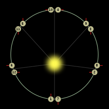
Orbit of Mercury (yellow). Dates refer to 2006.
 
Animation of Mercury's and Earth's revolution around the Sun

Mercury has the most eccentric orbit of all the planets; its eccentricity is 0.21 with its distance from the Sun ranging from 46,000,000 to 70,000,000 km (29,000,000 to 43,000,000 mi). It takes 87.969 Earth days to complete an orbit. The diagram on the right illustrates the effects of the eccentricity, showing Mercury's orbit overlaid with a circular orbit having the same semi-major axis. Mercury's higher velocity when it is near perihelion is clear from the greater distance it covers in each 5-day interval. In the diagram the varying distance of Mercury to the Sun is represented by the size of the planet, which is inversely proportional to Mercury's distance from the Sun. This varying distance to the Sun leads to Mercury's surface being flexed by tidal bulges raised by the Sun that are about 17 times stronger than the Moon's on Earth.[87] Combined with a 3:2 spin–orbit resonance of the planet's rotation around its axis, it also results in complex variations of the surface temperature.[21] The resonance makes a single solar day on Mercury last exactly two Mercury years, or about 176 Earth days.[88]

Mercury's orbit is inclined by 7 degrees to the plane of Earth's orbit (the ecliptic), as shown in the diagram on the right. As a result, transits of Mercury across the face of the Sun can only occur when the planet is crossing the plane of the ecliptic at the time it lies between Earth and the Sun. This occurs about every seven years on average.[89]

Mercury's axial tilt is almost zero,[90] with the best measured value as low as 0.027 degrees.[91] This is significantly smaller than that of Jupiter, which has the second smallest axial tilt of all planets at 3.1 degrees. This means that to an observer at Mercury's poles, the center of the Sun never rises more than 2.1 arcminutes above the horizon.[91]

At certain points on Mercury's surface, an observer would be able to see the Sun peek up about halfway over the horizon, then reverse and set before rising again, all within the same Mercurian day. This is because approximately four Earth days before perihelion, Mercury's angular orbital velocity equals its angular rotational velocity so that the Sun's apparent motion ceases; closer to perihelion, Mercury's angular orbital velocity then exceeds the angular rotational velocity. Thus, to a hypothetical observer on Mercury, the Sun appears to move in a retrograde direction. Four Earth days after perihelion, the Sun's normal apparent motion resumes.[21] A similar effect would have occurred if Mercury had been in synchronous rotation: the alternating gain and loss of rotation over revolution would have caused a libration of 23.65° in longitude.[92]

For the same reason, there are two points on Mercury's equator, 180 degrees apart in longitude, at either of which, around perihelion in alternate Mercurian years (once a Mercurian day), the Sun passes overhead, then reverses its apparent motion and passes overhead again, then reverses a second time and passes overhead a third time, taking a total of about 16 Earth-days for this entire process. In the other alternate Mercurian years, the same thing happens at the other of these two points. The amplitude of the retrograde motion is small, so the overall effect is that, for two or three weeks, the Sun is almost stationary overhead, and is at its most brilliant because Mercury is at perihelion, its closest to the Sun. This prolonged exposure to the Sun at its brightest makes these two points the hottest places on Mercury. Conversely, there are two other points on the equator, 90 degrees of longitude apart from the first ones, where the Sun passes overhead only when the planet is at aphelion in alternate years, when the apparent motion of the Sun in Mercury's sky is relatively rapid. These points, which are the ones on the equator where the apparent retrograde motion of the Sun happens when it is crossing the horizon as described in the preceding paragraph, receive much less solar heat than the first ones described above.

Mercury attains inferior conjunction (nearest approach to Earth) every 116 Earth days on average,[3] but this interval can range from 105 days to 129 days due to the planet's eccentric orbit. Mercury can come as near as 82.2 gigametres (0.549 astronomical units; 51.1 million miles) to Earth, and that is slowly declining: The next approach to within 82.1 Gm (51.0 million miles) is in 2679, and to within 82.0 Gm (51.0 million miles) in 4487, but it will not be closer to Earth than 80 Gm (50 million miles) until 28,622.[93] Its period of retrograde motion as seen from Earth can vary from 8 to 15 days on either side of inferior conjunction. This large range arises from the planet's high orbital eccentricity.[21]

Longitude convention

The longitude convention for Mercury puts the zero of longitude at one of the two hottest points on the surface, as described above. However, when this area was first visited, by Mariner 10, this zero meridian was in darkness, so it was impossible to select a feature on the surface to define the exact position of the meridian. Therefore, a small crater further west was chosen, called Hun Kal, which provides the exact reference point for measuring longitude. The center of Hun Kal defines the 20° West meridian. A 1970 International Astronomical Union resolution suggests that longitudes be measured positively in the westerly direction on Mercury.[94] The two hottest places on the equator are therefore at longitudes 0°W and 180°W, and the coolest points on the equator are at longitudes 90°W and 270°W. However, the MESSENGER project uses an east-positive convention.[95]

Spin–orbit resonance

After one orbit, Mercury has rotated 1.5 times, so after two complete orbits the same hemisphere is again illuminated.

For many years it was thought that Mercury was synchronously tidally locked with the Sun, rotating once for each orbit and always keeping the same face directed towards the Sun, in the same way that the same side of the Moon always faces Earth. Radar observations in 1965 proved that the planet has a 3:2 spin–orbit resonance, rotating three times for every two revolutions around the Sun. The eccentricity of Mercury's orbit makes this resonance stable—at perihelion, when the solar tide is strongest, the Sun is nearly still in Mercury's sky.[96]

The rare 3:2 resonant tidal locking is stabilized by the variance of the tidal force along Mercury's eccentric orbit, acting on a permanent dipole component of Mercury's mass distribution.[97] In a circular orbit there is no such variance, so the only resonance stabilized in such an orbit is at 1:1 (e.g., Earth–Moon), when the tidal force, stretching a body along the "center-body" line, exerts a torque that aligns the body's axis of least inertia (the "longest" axis, and the axis of the aforementioned dipole) to always point at the center. However, with noticeable eccentricity, like that of Mercury's orbit, the tidal force has a maximum at perihelion and thus stabilizes resonances, like 3:2, enforcing that the planet points its axis of least inertia roughly at the Sun when passing through perihelion.[97]

The original reason astronomers thought it was synchronously locked was that, whenever Mercury was best placed for observation, it was always nearly at the same point in its 3:2 resonance, hence showing the same face. This is because, coincidentally, Mercury's rotation period is almost exactly half of its synodic period with respect to Earth. Due to Mercury's 3:2 spin–orbit resonance, a solar day (the length between two meridian transits of the Sun) lasts about 176 Earth days.[21] A sidereal day (the period of rotation) lasts about 58.7 Earth days.[21]

Simulations indicate that the orbital eccentricity of Mercury varies chaotically from nearly zero (circular) to more than 0.45 over millions of years due to perturbations from the other planets.[21][98] This was thought to explain Mercury's 3:2 spin–orbit resonance (rather than the more usual 1:1), because this state is more likely to arise during a period of high eccentricity.[99] However, accurate modeling based on a realistic model of tidal response has demonstrated that Mercury was captured into the 3:2 spin–orbit state at a very early stage of its history, within 20 (more likely, 10) million years after its formation.[100]

Numerical simulations show that a future secular orbital resonant perihelion interaction with Jupiter may cause the eccentricity of Mercury's orbit to increase to the point where there is a 1% chance that the planet may collide with Venus within the next five billion years.[101][102]

Advance of perihelion

In 1859, the French mathematician and astronomer Urbain Le Verrier reported that the slow precession of Mercury's orbit around the Sun could not be completely explained by Newtonian mechanics and perturbations by the known planets. He suggested, among possible explanations, that another planet (or perhaps instead a series of smaller 'corpuscules') might exist in an orbit even closer to the Sun than that of Mercury, to account for this perturbation.[103] (Other explanations considered included a slight oblateness of the Sun.) The success of the search for Neptune based on its perturbations of the orbit of Uranus led astronomers to place faith in this possible explanation, and the hypothetical planet was named Vulcan, but no such planet was ever found.[104]
The perihelion precession of Mercury is 5,600 arcseconds (1.5556°) per century relative to Earth, or 574.10±0.65 arcseconds per century[105] relative to the inertial ICRF. Newtonian mechanics, taking into account all the effects from the other planets, predicts a precession of 5,557 arcseconds (1.5436°) per century.[105] In the early 20th century, Albert Einstein's general theory of relativity provided the explanation for the observed precession, by formalizing gravitation as being mediated by the curvature of spacetime. The effect is small: just 42.98 arcseconds per century for Mercury; it therefore requires a little over twelve million orbits for a full excess turn. Similar, but much smaller, effects exist for other Solar System bodies: 8.62 arcseconds per century for Venus, 3.84 for Earth, 1.35 for Mars, and 10.05 for 1566 Icarus.[106][107]
Albert Einstein's formula for the perihelion shift per revolution is {\displaystyle \epsilon =24\pi ^{3}{\frac {a^{2}}{T^{2}c^{2}(1-e^{2})}}}, where e is the orbital eccentricity, a the semi-major axis, and T the orbital period. Filling in the values gives a result of 0.1035 arcseconds per revolution or 0.4297 arcseconds per Earth year, i.e., 42.97 arcseconds per century.

Observation

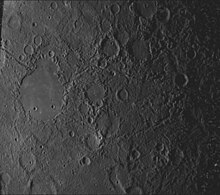
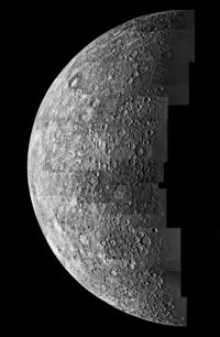
Image mosaic by Mariner 10, 1974

Mercury's apparent magnitude varies between −2.6[12] (brighter than the brightest star Sirius) and about +5.7 (approximating the theoretical limit of naked-eye visibility). The extremes occur when Mercury is close to the Sun in the sky.[12][13] Observation of Mercury is complicated by its proximity to the Sun, as it is lost in the Sun's glare for much of the time. Mercury can be observed for only a brief period during either morning or evening twilight.[108]

Mercury can, like several other planets and the brightest stars, be seen during a total solar eclipse.[109]

Like the Moon and Venus, Mercury exhibits phases as seen from Earth. It is "new" at inferior conjunction and "full" at superior conjunction. The planet is rendered invisible from Earth on both of these occasions because of its being obscured by the Sun,[108] except its new phase during a transit.

Mercury is technically brightest as seen from Earth when it is at a full phase. Although Mercury is farthest from Earth when it is full, the greater illuminated area that is visible and the opposition brightness surge more than compensates for the distance.[12] The opposite is true for Venus, which appears brightest when it is a crescent, because it is much closer to Earth than when gibbous.[12][110]

False-color map showing the maximum temperatures of the north polar region

Nonetheless, the brightest (full phase) appearance of Mercury is an essentially impossible time for practical observation, because of the extreme proximity of the Sun. Mercury is best observed at the first and last quarter, although they are phases of lesser brightness. The first and last quarter phases occur at greatest elongation east and west of the Sun, respectively. At both of these times Mercury's separation from the Sun ranges anywhere from 17.9° at perihelion to 27.8° at aphelion.[111][112] At greatest western elongation, Mercury rises at its earliest before sunrise, and at greatest eastern elongation, it sets at its latest after sunset.[113]
Mercury can be easily seen from the tropics and subtropics more than from higher latitudes. Viewed from low latitudes and at the right times of year, the ecliptic intersects the horizon at a steep angle. Mercury is 10° above the horizon when the planet appears directly above the Sun (i.e. its orbit appears vertical) and is at maximum elongation from the Sun (28°) and also when the Sun is 18° below the horizon, so the sky is just completely dark.[d] This angle is the maximum altitude at which Mercury is visible in a completely dark sky.

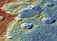
False-color image of Carnegie Rupes, a tectonic landform—high terrain (red); low (blue).

At middle latitudes, Mercury is more often and easily visible from the Southern Hemisphere than from the Northern. This is because Mercury's maximum western elongation occurs only during early autumn in the Southern Hemisphere, whereas its greatest eastern elongation happens only during late winter in the Southern Hemisphere.[113] In both of these cases, the angle at which the planet's orbit intersects the horizon is maximized, allowing it to rise several hours before sunrise in the former instance and not set until several hours after sundown in the latter from southern mid-latitudes, such as Argentina and South Africa.[113]

An alternate method for viewing Mercury involves observing the planet during daylight hours when conditions are clear, ideally when it is at its greatest elongation. This allows the planet to be found easily, even when using telescopes with 8 cm (3.1 in) apertures. Care must be taken to ensure the instrument isn't pointed directly towards the Sun because of the risk for eye damage. This method bypasses the limitation of twilight observing when the ecliptic is located at a low elevation (e.g. on autumn evenings).

Ground-based telescope observations of Mercury reveal only an illuminated partial disk with limited detail. The first of two spacecraft to visit the planet was Mariner 10, which mapped about 45% of its surface from 1974 to 1975. The second is the MESSENGER spacecraft, which after three Mercury flybys between 2008 and 2009, attained orbit around Mercury on March 17, 2011,[114] to study and map the rest of the planet.[115]

The Hubble Space Telescope cannot observe Mercury at all, due to safety procedures that prevent its pointing too close to the Sun.[116]

Because the shift of 0.15 revolutions in a year makes up a seven-year cycle (0.15 × 7 ≈ 1.0), in the seventh year Mercury follows almost exactly (earlier by 7 days) the sequence of phenomena it showed seven years before.[111]

Observation history

Ancient astronomers

Mercury, from Liber astronomiae, 1550

The earliest known recorded observations of Mercury are from the Mul.Apin tablets. These observations were most likely made by an Assyrian astronomer around the 14th century BC.[117] The cuneiform name used to designate Mercury on the Mul.Apin tablets is transcribed as Udu.Idim.Gu\u4.Ud ("the jumping planet").[e][118] Babylonian records of Mercury date back to the 1st millennium BC. The Babylonians called the planet Nabu after the messenger to the gods in their mythology.[119]

The ancient Greeks knew the planet as Στίλβων (Stilbon), meaning "the gleaming", Ἑρμάων (Hermaon) and Ἑρμής (Hermes),[120] a planetary name that is retained in modern Greek (Ερμής: Ermis).[121] The Romans named the planet after the swift-footed Roman messenger god, Mercury (Latin Mercurius), which they equated with the Greek Hermes, because it moves across the sky faster than any other planet.[122][123] The astronomical symbol for Mercury is a stylized version of Hermes' caduceus.[124]

The Roman-Egyptian astronomer Ptolemy wrote about the possibility of planetary transits across the face of the Sun in his work Planetary Hypotheses. He suggested that no transits had been observed either because planets such as Mercury were too small to see, or because the transits were too infrequent.[125]

Ibn al-Shatir's model for the appearances of Mercury, showing the multiplication of epicycles using the Tusi couple, thus eliminating the Ptolemaic eccentrics and equant.

In ancient China, Mercury was known as "the Hour Star" (Chen-xing 辰星). It was associated with the direction north and the phase of water in the Five Phases system of metaphysics.[126] Modern Chinese, Korean, Japanese and Vietnamese cultures refer to the planet literally as the "water star" (水星), based on the Five elements.[127][128][129] Hindu mythology used the name Budha for Mercury, and this god was thought to preside over Wednesday.[130] The god Odin (or Woden) of Germanic paganism was associated with the planet Mercury and Wednesday.[131] The Maya may have represented Mercury as an owl (or possibly four owls; two for the morning aspect and two for the evening) that served as a messenger to the underworld.[132]

In medieval Islamic astronomy, the Andalusian astronomer Abū Ishāq Ibrāhīm al-Zarqālī in the 11th century described the deferent of Mercury's geocentric orbit as being oval, like an egg or a pignon, although this insight did not influence his astronomical theory or his astronomical calculations.[133][134] In the 12th century, Ibn Bajjah observed "two planets as black spots on the face of the Sun", which was later suggested as the transit of Mercury and/or Venus by the Maragha astronomer Qotb al-Din Shirazi in the 13th century.[135] (Note that most such medieval reports of transits were later taken as observations of sunspots.[136])

In India, the Kerala school astronomer Nilakantha Somayaji in the 15th century developed a partially heliocentric planetary model in which Mercury orbits the Sun, which in turn orbits Earth, similar to the Tychonic system later proposed by Tycho Brahe in the late 16th century.[137]

Ground-based telescopic research

Transit of Mercury. Mercury is visible as a black dot below and to the left of center. The dark area above the center of the solar disk is a sunspot.
 
Elongation is the angle between the Sun and the planet, with Earth as the reference point. Mercury appears close to the Sun.

The first telescopic observations of Mercury were made by Galileo in the early 17th century. Although he observed phases when he looked at Venus, his telescope was not powerful enough to see the phases of Mercury. In 1631, Pierre Gassendi made the first telescopic observations of the transit of a planet across the Sun when he saw a transit of Mercury predicted by Johannes Kepler. In 1639, Giovanni Zupi used a telescope to discover that the planet had orbital phases similar to Venus and the Moon. The observation demonstrated conclusively that Mercury orbited around the Sun.[21]

A rare event in astronomy is the passage of one planet in front of another (occultation), as seen from Earth. Mercury and Venus occult each other every few centuries, and the event of May 28, 1737 is the only one historically observed, having been seen by John Bevis at the Royal Greenwich Observatory.[138] The next occultation of Mercury by Venus will be on December 3, 2133.[139]

The difficulties inherent in observing Mercury mean that it has been far less studied than the other planets. In 1800, Johann Schröter made observations of surface features, claiming to have observed 20-kilometre-high (12 mi) mountains. Friedrich Bessel used Schröter's drawings to erroneously estimate the rotation period as 24 hours and an axial tilt of 70°.[140] In the 1880s, Giovanni Schiaparelli mapped the planet more accurately, and suggested that Mercury's rotational period was 88 days, the same as its orbital period due to tidal locking.[141] This phenomenon is known as synchronous rotation. The effort to map the surface of Mercury was continued by Eugenios Antoniadi, who published a book in 1934 that included both maps and his own observations.[79] Many of the planet's surface features, particularly the albedo features, take their names from Antoniadi's map.[142]

In June 1962, Soviet scientists at the Institute of Radio-engineering and Electronics of the USSR Academy of Sciences, led by Vladimir Kotelnikov, became the first to bounce a radar signal off Mercury and receive it, starting radar observations of the planet.[143][144][145] Three years later, radar observations by Americans Gordon Pettengill and R. Dyce, using the 300-meter Arecibo Observatory radio telescope in Puerto Rico, showed conclusively that the planet's rotational period was about 59 days.[146][147] The theory that Mercury's rotation was synchronous had become widely held, and it was a surprise to astronomers when these radio observations were announced. If Mercury were tidally locked, its dark face would be extremely cold, but measurements of radio emission revealed that it was much hotter than expected. Astronomers were reluctant to drop the synchronous rotation theory and proposed alternative mechanisms such as powerful heat-distributing winds to explain the observations.[148]

Water ice (yellow) at Mercury's north polar region

Italian astronomer Giuseppe Colombo noted that the rotation value was about two-thirds of Mercury's orbital period, and proposed that the planet's orbital and rotational periods were locked into a 3:2 rather than a 1:1 resonance.[149] Data from Mariner 10 subsequently confirmed this view.[150] This means that Schiaparelli's and Antoniadi's maps were not "wrong". Instead, the astronomers saw the same features during every second orbit and recorded them, but disregarded those seen in the meantime, when Mercury's other face was toward the Sun, because the orbital geometry meant that these observations were made under poor viewing conditions.[140]

Ground-based optical observations did not shed much further light on Mercury, but radio astronomers using interferometry at microwave wavelengths, a technique that enables removal of the solar radiation, were able to discern physical and chemical characteristics of the subsurface layers to a depth of several meters.[151][152] Not until the first space probe flew past Mercury did many of its most fundamental morphological properties become known. Moreover, recent technological advances have led to improved ground-based observations. In 2000, high-resolution lucky imaging observations were conducted by the Mount Wilson Observatory 1.5 meter Hale telescope. They provided the first views that resolved surface features on the parts of Mercury that were not imaged in the Mariner 10 mission.[153] Most of the planet has been mapped by the Arecibo radar telescope, with 5 km (3.1 mi) resolution, including polar deposits in shadowed craters of what may be water ice.[154]

Research with space probes

MESSENGER being prepared for launch
 
Mercury transiting the Sun as viewed by the Mars rover Curiosity (June 3, 2014).[155]

Reaching Mercury from Earth poses significant technical challenges, because it orbits so much closer to the Sun than Earth. A Mercury-bound spacecraft launched from Earth must travel over 91 million kilometres (57 million miles) into the Sun's gravitational potential well. Mercury has an orbital speed of 48 km/s (30 mi/s), whereas Earth's orbital speed is 30 km/s (19 mi/s). Therefore, the spacecraft must make a large change in velocity (delta-v) to enter a Hohmann transfer orbit that passes near Mercury, as compared to the delta-v required for other planetary missions.[156]

The potential energy liberated by moving down the Sun's potential well becomes kinetic energy; requiring another large delta-v change to do anything other than rapidly pass by Mercury. To land safely or enter a stable orbit the spacecraft would rely entirely on rocket motors. Aerobraking is ruled out because Mercury has a negligible atmosphere. A trip to Mercury requires more rocket fuel than that required to escape the Solar System completely. As a result, only two space probes have visited it so far.[157] A proposed alternative approach would use a solar sail to attain a Mercury-synchronous orbit around the Sun.[158]

Mariner 10

Mariner 10, the first probe to visit Mercury

The first spacecraft to visit Mercury was NASA's Mariner 10 (1974–1975).[122] The spacecraft used the gravity of Venus to adjust its orbital velocity so that it could approach Mercury, making it both the first spacecraft to use this gravitational "slingshot" effect and the first NASA mission to visit multiple planets.[156] Mariner 10 provided the first close-up images of Mercury's surface, which immediately showed its heavily cratered nature, and revealed many other types of geological features, such as the giant scarps that were later ascribed to the effect of the planet shrinking slightly as its iron core cools.[159] Unfortunately, the same face of the planet was lit at each of Mariner 10's close approaches. This made close observation of both sides of the planet impossible,[160] and resulted in the mapping of less than 45% of the planet's surface.[161]

The spacecraft made three close approaches to Mercury, the closest of which took it to within 327 km (203 mi) of the surface.[162] At the first close approach, instruments detected a magnetic field, to the great surprise of planetary geologists—Mercury's rotation was expected to be much too slow to generate a significant dynamo effect. The second close approach was primarily used for imaging, but at the third approach, extensive magnetic data were obtained. The data revealed that the planet's magnetic field is much like Earth's, which deflects the solar wind around the planet. For many years after the Mariner 10 encounters, the origin of Mercury's magnetic field remained the subject of several competing theories.[163][164]

On March 24, 1975, just eight days after its final close approach, Mariner 10 ran out of fuel. Because its orbit could no longer be accurately controlled, mission controllers instructed the probe to shut down.[165] Mariner 10 is thought to be still orbiting the Sun, passing close to Mercury every few months.[166]

MESSENGER

Estimated details of the impact of MESSENGER on 30 April 2015

A second NASA mission to Mercury, named MESSENGER (MErcury Surface, Space ENvironment, GEochemistry, and Ranging), was launched on 3 August 2004. It made a fly-by of Earth in August 2005, and of Venus in October 2006 and June 2007 to place it onto the correct trajectory to reach an orbit around Mercury.[167] A first fly-by of Mercury occurred on January 14, 2008, a second on October 6, 2008,[168] and a third on September 29, 2009.[169] Most of the hemisphere not imaged by Mariner 10 was mapped during these fly-bys. The probe successfully entered an elliptical orbit around the planet on March 18, 2011. The first orbital image of Mercury was obtained on March 29, 2011. The probe finished a one-year mapping mission,[168] and then entered a one-year extended mission into 2013. In addition to continued observations and mapping of Mercury, MESSENGER observed the 2012 solar maximum.[170]

The mission was designed to clear up six key issues: Mercury's high density, its geological history, the nature of its magnetic field, the structure of its core, whether it has ice at its poles, and where its tenuous atmosphere comes from. To this end, the probe carried imaging devices that gathered much-higher-resolution images of much more of Mercury than Mariner 10, assorted spectrometers to determine abundances of elements in the crust, and magnetometers and devices to measure velocities of charged particles. Measurements of changes in the probe's orbital velocity were expected to be used to infer details of the planet's interior structure.[171] MESSENGER's final maneuver was on April 24, 2015, and it crashed into Mercury's surface on April 30, 2015.[172][173][174] The spacecraft's impact with Mercury occurred near 3:26 PM EDT on April 30, 2015, leaving a crater estimated to be 16 m (52 ft) in diameter.[175]

First (29 March 2011) and last (30 April 2015) images of
Mercury by MESSENGER

BepiColombo

The European Space Agency is planning a joint mission with Japan called BepiColombo, which will orbit Mercury with two probes: one to map the planet and the other to study its magnetosphere.[176] Once launched in 2018, BepiColombo is expected to reach Mercury in 2025.[177] It will release a magnetometer probe into an elliptical orbit, then chemical rockets will fire to deposit the mapper probe into a circular orbit. Both probes will operate for one terrestrial year.[176] The mapper probe will carry an array of spectrometers similar to those on MESSENGER, and will study the planet at many different wavelengths including infrared, ultraviolet, X-ray and gamma ray.[178]

Cooperative

From Wikipedia, the free encyclopedia ...