Search This Blog

Monday, July 9, 2018

Biogeography

From Wikipedia, the free encyclopedia
 
Frontispiece to Alfred Russel Wallace's book The Geographical Distribution of Animals

Biogeography is the study of the distribution of species and ecosystems in geographic space and through geological time. Organisms and biological communities often vary in a regular fashion along geographic gradients of latitude, elevation, isolation and habitat area. Phytogeography is the branch of biogeography that studies the distribution of plants. Zoogeography is the branch that studies distribution of animals.

Knowledge of spatial variation in the numbers and types of organisms is as vital to us today as it was to our early human ancestors, as we adapt to heterogeneous but geographically predictable environments. Biogeography is an integrative field of inquiry that unites concepts and information from ecology, evolutionary biology, geology, and physical geography.[2]

Modern biogeographic research combines information and ideas from many fields, from the physiological and ecological constraints on organismal dispersal to geological and climatological phenomena operating at global spatial scales and evolutionary time frames.

The short-term interactions within a habitat and species of organisms describe the ecological application of biogeography. Historical biogeography describes the long-term, evolutionary periods of time for broader classifications of organisms.[3] Early scientists, beginning with Carl Linnaeus, contributed to the development of biogeography as a science. Beginning in the mid-18th century, Europeans explored the world and discovered the biodiversity of life.

The scientific theory of biogeography grows out of the work of Alexander von Humboldt (1769–1859),[4] Hewett Cottrell Watson (1804–1881),[5] Alphonse de Candolle (1806–1893),[6] Alfred Russel Wallace (1823–1913),[7] Philip Lutley Sclater (1829–1913) and other biologists and explorers.[8]

Introduction

The patterns of species distribution across geographical areas can usually be explained through a combination of historical factors such as: speciation, extinction, continental drift, and glaciation. Through observing the geographic distribution of species, we can see associated variations in sea level, river routes, habitat, and river capture. Additionally, this science considers the geographic constraints of landmass areas and isolation, as well as the available ecosystem energy supplies.

Over periods of ecological changes, biogeography includes the study of plant and animal species in: their past and/or present living refugium habitat; their interim living sites; and/or their survival locales.[9] As writer David Quammen put it, "...biogeography does more than ask Which species? and Where. It also asks Why? and, what is sometimes more crucial, Why not?."[10]

Modern biogeography often employs the use of Geographic Information Systems (GIS), to understand the factors affecting organism distribution, and to predict future trends in organism distribution.[11] Often mathematical models and GIS are employed to solve ecological problems that have a spatial aspect to them.[12]

Biogeography is most keenly observed on the world's islands. These habitats are often much more manageable areas of study because they are more condensed than larger ecosystems on the mainland.[13] Islands are also ideal locations because they allow scientists to look at habitats that new invasive species have only recently colonized and can observe how they disperse throughout the island and change it. They can then apply their understanding to similar but more complex mainland habitats. Islands are very diverse in their biomes, ranging from the tropical to arctic climates. This diversity in habitat allows for a wide range of species study in different parts of the world.

One scientist who recognized the importance of these geographic locations was Charles Darwin, who remarked in his journal "The Zoology of Archipelagoes will be well worth examination".[13] Two chapters in On the Origin of Species were devoted to geographical distribution.

History

18th century

The first discoveries that contributed to the development of biogeography as a science began in the mid-18th century, as Europeans explored the world and discovered the biodiversity of life. During the 18th century most views on the world were shaped around religion and for many natural theologists, the bible. Carl Linnaeus, in the mid-18th century, initiated the ways to classify organisms through his exploration of undiscovered territories. When he noticed that species were not as perpetual as he believed, he developed the Mountain Explanation to explain the distribution of biodiversity. When Noah's ark landed on Mount Ararat and the waters receded, the animals dispersed throughout different elevations on the mountain. This showed different species in different climates proving species were not constant.[3] Linnaeus' findings set a basis for ecological biogeography. Through his strong beliefs in Christianity, he was inspired to classify the living world, which then gave way to additional accounts of secular views on geographical distribution.[8] He argued that the structure of an animal was very closely related to its physical surroundings. This was important to a George Louis Buffon's rival theory of distribution.[8]

Edward O. Wilson, a prominent biologist and conservationist, coauthored The Theory of Island Biogeography and helped to start much of the research that has been done on this topic since the work of Watson and Wallace almost a century before

Closely after Linnaeus, Georges-Louis Leclerc, Comte de Buffon observed shifts in climate and how species spread across the globe as a result. He was the first to see different groups of organisms in different regions of the world. Buffon saw similarities between some regions which led him to believe that at one point continents were connected and then water separated them and caused differences in species. His hypotheses were described by his books, Histoire Naturelle, and Générale et Particulière, in which he argued that varying geographical regions would have different forms of life. This was inspired by his observations comparing the Old and New World, as he determined distinct variations of species from the two regions. Buffon believed there was a single species creation event, and that different regions of the world were homes for varying species, which is an alternate view than that of Linnaeus. Buffon's law eventually became a principle of biogeography by explaining how similar environments were habitats for comparable types of organisms.[8] Buffon also studied fossils which led him to believe that the earth was over tens of thousands of years old, and that humans had not lived there long in comparison to the age of the earth.[3]

Following this period of exploration came the Age of Enlightenment in Europe, which attempted to explain the patterns of biodiversity observed by Buffon and Linnaeus. At the end of the 18th century, Alexander von Humboldt, known as the "founder of plant geography",[3] developed the concept of physique generale to demonstrate the unity of science and how species fit together. As one of the first to contribute empirical data to the science of biogeography through his travel as an explorer, he observed differences in climate and vegetation. The earth was divided into regions which he defined as tropical, temperate, and arctic and within these regions there were similar forms of vegetation.[3] This ultimately enabled him to create the isotherm, which allowed scientists to see patterns of life within different climates.[3] He contributed his observations to findings of botanical geography by previous scientists, and sketched this description of both the biotic and abiotic features of the earth in his book, Cosmos.[8]

Augustin de Candolle contributed to the field of biogeography as he observed species competition and the several differences that influenced the discovery of the diversity of life. He was a Swiss botanist and created the first Laws of Botanical Nomenclature in his work, Prodromus.[14] He discussed plant distribution and his theories eventually had a great impact on Charles Darwin, who was inspired to consider species adaptations and evolution after learning about botanical geography. De Candolle was the first to describe the differences between the small-scale and large-scale distribution patterns of organisms around the globe.[8]

19th century

In the 19th century, several additional scientists contributed new theories to further develop the concept of biogeography. Charles Lyell, being one of the first contributors in the 19th century, developed the Theory of Uniformitarianism after studying fossils. This theory explained how the world was not created by one sole catastrophic event, but instead from numerous creation events and locations.[15] Uniformitarianism also introduced the idea that the Earth was actually significantly older than was previously accepted. Using this knowledge, Lyell concluded that it was possible for species to go extinct.[16] Since he noted that earth’s climate changes, he realized that species distribution must also change accordingly. Lyell argued that climate changes complemented vegetation changes, thus connecting the environmental surroundings to varying species. This largely influenced Charles Darwin in his development of the theory of evolution.[8]

Charles Darwin was a natural theologist who studied around the world, and most importantly in the Galapagos Islands. Darwin introduced the idea of natural selection, as he theorized against previously accepted ideas that species were static or unchanging. His contributions to biogeography and the theory of evolution were different from those of other explorers of his time, because he developed a mechanism to describe the ways that species changed. His influential ideas include the development of theories regarding the struggle for existence and natural selection. Darwin's theories started a biological segment to biogeography and empirical studies, which enabled future scientists to develop ideas about the geographical distribution of organisms around the globe.[8]

Alfred Russel Wallace studied the distribution of flora and fauna in the Amazon Basin and the Malay Archipelago in the mid-19th century. His research was essential to the further development of biogeography, and he was later nicknamed the "father of Biogeography". Wallace conducted fieldwork researching the habits, breeding and migration tendencies, and feeding behavior of thousands of species. He studied butterfly and bird distributions in comparison to the presence or absence of geographical barriers. His observations led him to conclude that the number of organisms present in a community was dependent on the amount of food resources in the particular habitat.[8] Wallace believed species were dynamic by responding to biotic and abiotic factors. He and Philip Sclater saw biogeography as a source of support for the theory of evolution as they used Darwin's conclusion to explain how biogeography was similar to a record of species inheritance.[8] Key findings, such as the sharp difference in fauna either side of the Wallace Line, and the sharp difference that existed between North and South America prior to their relatively recent faunal interchange, can only be understood in this light. Otherwise, the field of biogeography would be seen as a purely descriptive one.[3]

Schematic distribution of fossils on Pangea according to Wegener

20th and 21st century

Distribution of four Permian and Triassic fossil groups used as biogeographic evidence for continental drift, and land bridging

Moving on to the 20th century, Alfred Wegener introduced the Theory of Continental Drift in 1912, though it was not widely accepted until the 1960s.[3] This theory was revolutionary because it changed the way that everyone thought about species and their distribution around the globe. The theory explained how continents were formerly joined together in one large landmass, Pangea, and slowly drifted apart due to the movement of the plates below Earth's surface. The evidence for this theory is in the geological similarities between varying locations around the globe, fossil comparisons from different continents, and the jigsaw puzzle shape of the landmasses on Earth. Though Wegener did not know the mechanism of this concept of Continental Drift, this contribution to the study of biogeography was significant in the way that it shed light on the importance of environmental and geographic similarities or differences as a result of climate and other pressures on the planet. Importantly, late in his career Wegener recognised that testing his theory required measurement of continental movement rather than inference from fossils species distributions[17].

The publication of The Theory of Island Biogeography by Robert MacArthur and E.O. Wilson in 1967[18] showed that the species richness of an area could be predicted in terms of such factors as habitat area, immigration rate and extinction rate. This added to the long-standing interest in island biogeography. The application of island biogeography theory to habitat fragments spurred the development of the fields of conservation biology and landscape ecology.[19]

Classic biogeography has been expanded by the development of molecular systematics, creating a new discipline known as phylogeography. This development allowed scientists to test theories about the origin and dispersal of populations, such as island endemics. For example, while classic biogeographers were able to speculate about the origins of species in the Hawaiian Islands, phylogeography allows them to test theories of relatedness between these populations and putative source populations in Asia and North America.[20]

Biogeography continues as a point of study for many life sciences and geography students worldwide, however it may be under different broader titles within institutions such as ecology or evolutionary biology.

In recent years, one of the most important and consequential developments in biogeography has been to show how multiple organisms, including mammals like monkeys and reptiles like lizards, overcame barriers such as large oceans that many biogeographers formerly believed were impossible to cross.[21] See also Oceanic dispersal.

Biogeographic regions of Europe

Modern applications

Biogeography now incorporates many different fields including but not limited to physical geography, geology, botany and plant biology, zoology, and general biology. A biogeographer's main focus is on what environmental factors and what the influence of humans do to the distribution of the specific species of study. In terms of applications of biogeography as a science today, technological advances have allowed satellite imaging and processing of the Earth.[22] Two main types of satellite imaging that are important within modern biogeography are Global Production Efficiency Model (GLO-PEM) and Geographic Information Systems (GIS). GLO-PEM uses satellite-imaging gives "repetitive, spatially contiguous, and time specific observations of vegetation". These observations are on a global scale.[23] GIS can show certain processes on the earth’s surface like whale locations, sea surface temperatures, and bathymetry.[24] Current scientists also use coral reefs to delve into the history of biogeography through the fossilized reefs.

Paleobiogeography

Paleobiogeography goes one step further to include paleogeographic data and considerations of plate tectonics. Using molecular analyses and corroborated by fossils, it has been possible to demonstrate that perching birds evolved first in the region of Australia or the adjacent Antarctic (which at that time lay somewhat further north and had a temperate climate). From there, they spread to the other Gondwanan continents and Southeast Asia – the part of Laurasia then closest to their origin of dispersal – in the late Paleogene, before achieving a global distribution in the early Neogene.[25] Not knowing that at the time of dispersal, the Indian Ocean was much narrower than it is today, and that South America was closer to the Antarctic, one would be hard pressed to explain the presence of many "ancient" lineages of perching birds in Africa, as well as the mainly South American distribution of the suboscines.

Paleobiogeography also helps constrain hypotheses on the timing of biogeographic events such as vicariance and geodispersal, and provides unique information on the formation of regional biotas. For example, data from species-level phylogenetic and biogeographic studies tell us that the Amazonian fish fauna accumulated in increments over a period of tens of millions of years, principally by means of allopatric speciation, and in an arena extending over most of the area of tropical South America (Albert & Reis 2011). In other words, unlike some of the well-known insular faunas (Galapagos finches, Hawaiian drosophilid flies, African rift lake cichlids), the species-rich Amazonian ichthyofauna is not the result of recent adaptive radiations.[26]

For freshwater organisms, landscapes are divided naturally into discrete drainage basins by watersheds, episodically isolated and reunited by erosional processes. In regions like the Amazon Basin (or more generally Greater Amazonia, the Amazon basin, Orinoco basin, and Guianas) with an exceptionally low (flat) topographic relief, the many waterways have had a highly reticulated history over geological time. In such a context, stream capture is an important factor affecting the evolution and distribution of freshwater organisms. Stream capture occurs when an upstream portion of one river drainage is diverted to the downstream portion of an adjacent basin. This can happen as a result of tectonic uplift (or subsidence), natural damming created by a landslide, or headward or lateral erosion of the watershed between adjacent basins.[26]

Concepts and fields

Biogeography is a synthetic science, related to geography, biology, soil science, geology, climatology, ecology and evolution.

Some fundamental concepts in biogeography include:
  • allopatric speciation – the splitting of a species by evolution of geographically isolated populations
  • evolution – change in genetic composition of a population
  • extinction – disappearance of a species
  • dispersal – movement of populations away from their point of origin, related to migration
  • endemic areas
  • geodispersal – the erosion of barriers to biotic dispersal and gene flow, that permit range expansion and the merging of previously isolated biotas
  • range and distribution
  • vicariance – the formation of barriers to biotic dispersal and gene flow, that tend to subdivide species and biotas, leading to speciation and extinction; vicariance biogeography is the field that studies these patterns

Comparative biogeography

The study of comparative biogeography can follow two main lines of investigation:[27]
  • Systematic biogeography, the study of biotic area relationships, their distribution, and hierarchical classification
  • Evolutionary biogeography, the proposal of evolutionary mechanisms responsible for organismal distributions. Possible mechanisms include widespread taxa disrupted by continental break-up or individual episodes of long-distance movement.

Biogeographic regionalisations

There are many types of biogeographic units used in biogeographic regionalisation schemes,[28][29][30] as there are many criteria (species composition, physiognomy, ecological aspects) and hierarchization schemes: biogeographic realms (or ecozones), bioregions (sensu stricto), ecoregions, zoogeographical regions, floristic regions, vegetation types, biomes, etc.

The terms biogeographic unit,[31] biogeographic area[32] or bioregion sensu lato,[33] can be used for these categories, regardless of rank.

Recently, an International Code of Area Nomenclature was proposed for biogeography.

Tundra

From Wikipedia, the free encyclopedia

Tundra
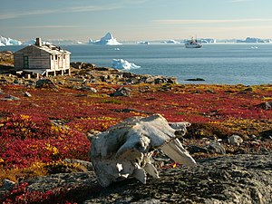
Greenland scoresby-sydkapp2 hg.jpg
Tundra in Greenland
 
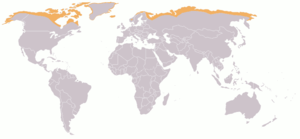
800px-Map-Tundra.png
Map showing Arctic tundra
 
Geography
Area 11,563,300 km2 (4,464,600 sq mi)
Climate type ET

In physical geography, tundra (/ˈtʌndrə, ˈtʊn-/) is a type of biome where the tree growth is hindered by low temperatures and short growing seasons. The term tundra comes through Russian тундра (tûndra) from the Kildin Sami word тӯндар (tūndâr) meaning "uplands", "treeless mountain tract". There are three types of tundra: Arctic tundra, alpine tundra, and Antarctic tundra. In tundra, the vegetation is composed of dwarf shrubs, sedges and grasses, mosses, and lichens. Scattered trees grow in some tundra regions. The ecotone (or ecological boundary region) between the tundra and the forest is known as the tree line or timberline.

Arctic

Arctic tundra occurs in the far Northern Hemisphere, north of the taiga belt. The word "tundra" usually refers only to the areas where the subsoil is permafrost, or permanently frozen soil. (It may also refer to the treeless plain in general, so that northern Sápmi would be included.) Permafrost tundra includes vast areas of northern Russia and Canada.[2] The polar tundra is home to several peoples who are mostly nomadic reindeer herders, such as the Nganasan and Nenets in the permafrost area (and the Sami in Sápmi).
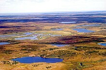
Tundra in Siberia

Arctic tundra contains areas of stark landscape and is frozen for much of the year. The soil there is frozen from 25 to 90 cm (10 to 35 in) down, and it is impossible for trees to grow. Instead, bare and sometimes rocky land can only support low growing plants such as moss, heath (Ericaceae varieties such as crowberry and black bearberry), and lichen. There are two main seasons, winter and summer, in the polar tundra areas. During the winter it is very cold and dark, with the average temperature around −28 °C (−18 °F), sometimes dipping as low as −50 °C (−58 °F). However, extreme cold temperatures on the tundra do not drop as low as those experienced in taiga areas further south (for example, Russia's and Canada's lowest temperatures were recorded in locations south of the tree line). During the summer, temperatures rise somewhat, and the top layer of seasonally-frozen soil melts, leaving the ground very soggy. The tundra is covered in marshes, lakes, bogs and streams during the warm months. Generally daytime temperatures during the summer rise to about 12 °C (54 °F) but can often drop to 3 °C (37 °F) or even below freezing. Arctic tundras are sometimes the subject of habitat conservation programs. In Canada and Russia, many of these areas are protected through a national Biodiversity Action Plan.


Tundra tends to be windy, with winds often blowing upwards of 50–100 km/h (30–60 mph). However, in terms of precipitation, it is desert-like, with only about 15–25 cm (6–10 in) falling per year (the summer is typically the season of maximum precipitation). Although precipitation is light, evaporation is also relatively minimal. During the summer, the permafrost thaws just enough to let plants grow and reproduce, but because the ground below this is frozen, the water cannot sink any lower, and so the water forms the lakes and marshes found during the summer months. There is a natural pattern of accumulation of fuel and wildfire which varies depending on the nature of vegetation and terrain. Research in Alaska has shown fire-event return intervals (FRIs) that typically vary from 150 to 200 years, with dryer lowland areas burning more frequently than wetter highland areas.[4]
 
A group of muskoxen in Alaska

The biodiversity of tundra is low: 1,700 species of vascular plants and only 48 species of land mammals can be found, although millions of birds migrate there each year for the marshes.[5] There are also a few fish species. There are few species with large populations. Notable animals in the Arctic tundra include caribou (reindeer), musk ox, Arctic hare, Arctic fox, snowy owl, lemmings, and polar bears (only near ocean-fed bodies of water).[6] Tundra is largely devoid of poikilotherms such as frogs or lizards.

Due to the harsh climate of Arctic tundra, regions of this kind have seen little human activity, even though they are sometimes rich in natural resources such as oil and uranium. In recent times this has begun to change in Alaska, Russia, and some other parts of the world.

Relationship with global warming

A severe threat to tundra is global warming, which causes permafrost to melt. The melting of the permafrost in a given area on human time scales (decades or centuries) could radically change which species can survive there.[7]

Another concern is that about one third of the world's soil-bound carbon is in taiga and tundra areas. When the permafrost melts, it releases carbon in the form of carbon dioxide and methane,[8] both of which are greenhouse gases. The effect has been observed in Alaska. In the 1970s the tundra was a carbon sink, but today, it is a carbon source.[9] Methane is produced when vegetation decays in lakes and wetlands.[10]

The amount of greenhouse gases which will be released under projected scenarios for global warming have not been reliably quantified by scientific studies, although a few studies were reported to be underway in 2011. It is uncertain whether the impact of increased greenhouse gases from this source will be minimal or massive.[10]

In locations where dead vegetation and peat has accumulated there is a risk of wildfire such as the 1,039 km2 (401 sq mi) of tundra which burned in 2007 on the north slope of the Brooks Range in Alaska.[10] Such events may both result from and contribute to global warming.[11]

Antarctic

Tundra on the Péninsule Rallier du Baty, Kerguelen Islands.

Antarctic tundra occurs on Antarctica and on several Antarctic and subantarctic islands, including South Georgia and the South Sandwich Islands and the Kerguelen Islands. Most of Antarctica is too cold and dry to support vegetation, and most of the continent is covered by ice fields. However, some portions of the continent, particularly the Antarctic Peninsula, have areas of rocky soil that support plant life. The flora presently consists of around 300–400 lichens, 100 mosses, 25 liverworts, and around 700 terrestrial and aquatic algae species, which live on the areas of exposed rock and soil around the shore of the continent. Antarctica's two flowering plant species, the Antarctic hair grass (Deschampsia antarctica) and Antarctic pearlwort (Colobanthus quitensis), are found on the northern and western parts of the Antarctic Peninsula.[12] In contrast with the Arctic tundra, the Antarctic tundra lacks a large mammal fauna, mostly due to its physical isolation from the other continents. Sea mammals and sea birds, including seals and penguins, inhabit areas near the shore, and some small mammals, like rabbits and cats, have been introduced by humans to some of the subantarctic islands. The Antipodes Subantarctic Islands tundra ecoregion includes the Bounty Islands, Auckland Islands, Antipodes Islands, the Campbell Island group, and Macquarie Island.[13] Species endemic to this ecoregion include Nematoceras dienemum and Nematoceras sulcatum, the only subantarctic orchids; the royal penguin; and the Antipodean albatross.[13]

There is some ambiguity on whether Magellanic moorland, on the west coast of Patagonia, should be considered tundra or not.[14] Phytogeographer Edmundo Pisano called it tundra (Spanish: tundra Magallánica) since he considered the low temperatures key to restrict plant growth.[14]

The flora and fauna of Antarctica and the Antarctic Islands (south of 60° south latitude) are protected by the Antarctic Treaty.[15]

Alpine

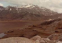
Alpine tundra at Venezuelan Andes

Alpine tundra does not contain trees because the climate and soils at high altitude block tree growth. Alpine tundra is distinguished from arctic tundra in that alpine tundra typically does not have permafrost, and alpine soils are generally better drained than arctic soils. Alpine tundra transitions to subalpine forests below the tree line; stunted forests occurring at the forest-tundra ecotone (the treeline) are known as Krummholz.

Alpine tundra occurs in mountains worldwide. The flora of the alpine tundra is characterized by dwarf shrubs close to the ground. The cold climate of the alpine tundra is caused by the low air temperatures, and is similar to polar climate.

Climatic classification

Tundra region with fjords, glaciers and mountains. Kongsfjorden, Spitsbergen.

Tundra climates ordinarily fit the Köppen climate classification ET, signifying a local climate in which at least one month has an average temperature high enough to melt snow (0 °C (32 °F)), but no month with an average temperature in excess of 10 °C (50 °F). The cold limit generally meets the EF climates of permanent ice and snows; the warm-summer limit generally corresponds with the poleward or altitudinal limit of trees, where they grade into the subarctic climates designated Dfd, Dwd and Dsd (extreme winters as in parts of Siberia), Dfc typical in Alaska, Canada, parts of Scandinavia, European Russia, and Western Siberia (cold winters with months of freezing), or even Cfc (no month colder than −3 °C (27 °F) as in parts of Iceland and southernmost South America). Tundra climates as a rule are hostile to woody vegetation even where the winters are comparatively mild by polar standards, as in Iceland.

Despite the potential diversity of climates in the ET category involving precipitation, extreme temperatures, and relative wet and dry seasons, this category is rarely subdivided. Rainfall and snowfall are generally slight due to the low vapor pressure of water in the chilly atmosphere, but as a rule potential evapotranspiration is extremely low, allowing soggy terrain of swamps and bogs even in places that get precipitation typical of deserts of lower and middle latitudes. The amount of native tundra biomass depends more on the local temperature than the amount of precipitation.

Mammoth steppe

From Wikipedia, the free encyclopedia

Ukok Plateau, one of the last remnants of the mammoth steppe[1]

During the Last Glacial Maximum, the mammoth steppe was the Earth’s most extensive biome. It spanned from Spain eastwards across Eurasia to Canada and from the arctic islands southwards to China. It had a cold, dry climate, the vegetation was dominated by palatable high-productivity grasses, herbs and willow shrubs, and the animal biomass was dominated by the bison, horse, and the woolly mammoth. This ecosystem covered wide areas of the northern part of the globe, thrived for approximately 100,000 years without major changes, and then suddenly became all but extinct about 12,000 years ago.

Naming

At the end of the 19th century, Alfred Nehring (1890)[9] and Iwan Dementjewitsch Chersky (Tscherski, 1891)[10] proposed that during the last glacial period a major part of northern Europe had been populated by large herbivores and that a steppe climate had prevailed there.[11] In 1982, the scientist R. Dale Guthrie coined the term "mammoth steppe" for this paleoregion.

Origin of the mammoth steppe

The last glacial period, commonly referred to as the 'Ice Age', spanned from 126,000 YBP–11,700 YBP[13] and was the most recent glacial period within the current ice age which occurred during the last years of the Pleistocene era.[14] It reached its peak during the last glacial maximum, when ice sheets commenced advancing from 33,000 years BP and reached their maximum positions 26,500 years BP. Deglaciation commenced in the Northern Hemisphere approximately 19,000 years BP, and in Antarctica approximately 14,500 years BP, which is consistent with evidence that it was the primary source for an abrupt rise in the sea level at that time.[15]

During the peak of the last glacial maximum, a vast mammoth steppe stretched from Spain across Eurasia and over the Bering land bridge into Alaska and the Yukon where it was stopped by the Wisconsin glaciation. This land bridge existed because more of the planet's water was locked up in ice than now and therefore the sea levels were lower. When the sea levels began to rise this bridge was inundated around 11,000 years BP.[16]

During glacial periods, there is clear evidence for intense aridity due to water being held in glaciers and their associated effects on climate.[17][18][7] The mammoth steppe was like a huge 'inner court' that was surrounded on all sides by moisture-blocking features: massive continental glaciers, high mountains, and frozen seas. These kept rainfall low and created more days with clear skies than are seen today, which increased evaporation in the summer leading to aridity, and radiation of warmth from the ground into the black night sky in the winter leading to cold.[7] This is thought to have been caused by seven factors:
  1. The driving force for the core Asian steppe was an enormous and stable high-pressure system north of the Tibetan Plateau.
  2. Deflection of the larger portion of the Gulf Stream southward, past southern Spain onto the coast of Africa, reduced temperatures (hence moisture and cloud cover) that the North Atlantic Current brings to Western Europe.
  3. Growth of the Scandinavian ice sheet created a barrier to North Atlantic moisture.
  4. Icing over of the North Atlantic sea surface with reduced flow of moisture from the east.
  5. The winter (January) storm track seems to have swept across Eurasia on this axis.
  6. Lowered sea levels exposed a large continental shelf to the north and east producing a vast northern plain which increased the size of the continent to the north.
  7. North American glaciers shielded interior Alaska and the Yukon Territory from moisture flow. These physical barriers to moisture flow created a vast arid basin or protected 'inner court' spanning parts of three continents.[7]

Biota

Climatic suitability for the woolly mammoths in the Late Pleistocene and Holocene. Increasing intensities of red represent increasing suitability of the climate and increasing intensities of green represent decreasing suitability. Black points are the records of mammoth presence for each of the periods. Black lines represent the northern limit of modern humans and black dotted lines indicate uncertainty in the limit of modern humans (D. Nogués-Bravo et al. 2008).[19]

Animal biomass and plant productivity of the mammoth steppe were similar to today's African savannah.[6] There is no comparison to it today.[7][6]

Plants

The paleo-environment changed across time,[20] a proposal that is supported from mammoth dung samples found in northern Yakutia.[21] During Pleniglacial interstadials, alder, birch, and pine trees survived in northern Siberia, however during the Last Glacial Maximum only a treeless steppe vegetation existed. At the onset of the Late Glacial Interstadial (15,000–11,000 BP), global warming resulted in shrub and dwarf birch in northeastern Siberia, which was then colonized by open woodland with birch and spruce during the Younger Dryas (12,900–11,700 YBP). By the Holocene (10,000 YBP), patches of closed larch and pine forests developed.[21] Past researchers had once assumed that the mammoth steppe was very unproductive because they had assumed that its soils had a very low carbon content; however, these soils (yedoma) were preserved in the permafrost of Siberia and Alaska and are the largest reservoir of organic carbon known. It was a highly productive environment.[6][22] The vegetation was dominated by palatable high-productivity grasses, herbs and willow shrubs.[3][6][8]

Animals

The mammoth steppe was dominated in biomass by bison, horse, and the woolly mammoth, and was the center for the evolution of the Pleistocene woolly fauna.[7] On Wrangel Island, the remains of woolly mammoth, woolly rhinoceros, horse, bison and musk ox have been found. Reindeer and small animal remains do not preserve, but reindeer excrement has been found in sediment.[6] In the most arid regions of the mammoth steppe that were to the south of Central Siberia and Mongolia, woolly rhinoceros were common[23][6] but woolly mammoths were rare.[24][6] Reindeer live in the far north of Mongolia today and historically their southern boundary passed through Germany and along the steppes of eastern Europe,[25][6] indicating they once covered much of the mammoth steppe.[6] Mammoths survived on the Taimyr Peninsula until the Holocene.[8][6] A small population of mammoth survived on St. Paul Island, Alaska, up until 3750 BC,[26][27] and the small[28] mammoths of Wrangel Island survived until 1650 BC.[29][30] Bison in Alaska and the Yukon, and horses and muskox in northern Siberia, have survived the loss of the mammoth steppe.[6] One study has proposed that a change of suitable climate caused a significant drop in the mammoth population size, which made them vulnerable to hunting from expanding human populations. The coincidence of both of these impacts in the Holocene most likely set the place and time for the extinction of the woolly mammoth.[19]

Decline of the mammoth steppe

The mammoth steppe had a cold, dry climate.[7][6] During the past interglacial warmings, forests of trees and shrubs expanded northwards into the mammoth steppe, when northern Siberia, Alaska and the Yukon (Beringia) would have formed a mammoth steppe refugium. When the planet grew colder again, the mammoth steppe expanded.[6] This ecosystem covered wide areas of the northern part of the globe, thrived for approximately 100,000 years without major changes, and then suddenly became extinct about 12,000 years ago.[7]

There are two theories about the decline of the mammoth steppe.

Climate change

The Climatic Hypothesis assumes that the vast mammoth ecosystem could have only existed within a certain range of climatic parameters. At the beginning of the Holocene 10,000 years ago, mossy forests, tundra, lakes and wetlands displaced mammoth steppe. It has been assumed that in contrast to other previous interglacials the cold dry climate switched to a warmer wetter climate that, in turn, caused the disappearance of the grasslands and their dependent megafauna.[3]

The extinct steppe bison (Bison priscus) survived across the northern region of central eastern Siberia until 8000 years ago. A study of the frozen mummy of a steppe bison found in northern Yakutia, Russia indicated that it was a pasture grazer in a habitat that was becoming dominated by shrub and tundra vegetation. Higher temperature and rainfall led to a decrease in its previous habitat during the early Holocene, and this led to population fragmentation followed by extinction.[31]

In 2017 a study looked at the environmental conditions across Europe, Siberia and the Americas from 25,000–10,000 YBP. The study found that prolonged warming events leading to deglaciation and maximum rainfall occurred just prior to the transformation of the rangelands that supported megaherbivores into widespread wetlands that supported herbivore-resistant plants. The study proposes that moisture-driven environmental change led to the megafaunal extinctions, and that Africa's trans-equatorial position allowed rangeland to continue to exist between the deserts and the central forests; therefore fewer megafauna species became extinct there.[32]

Human predation

The Ecosystem Hypothesis assumes that the vast mammoth ecosystem extended over a range of many regional climates and was not affected by climate fluctuations. Its highly productive grasslands were maintained by animals trampling any mosses and shrubs, and actively transpiring grasses and herbs dominated. At the beginning of the Holocene the rise in precipitation was accompanied by increased temperature, and so its climatic aridity did not change substantially. As a result of human hunting, the decreasing density of the animals was not enough to maintain the grasslands, leading to an increase in forests, shrubs and mosses with further animal reduction due to loss of feed. The mammoth continued to exist on isolated Wrangel Island until a few thousand years ago, and some of the other megafauna from that time still exist today, which indicates that something other than climate change was responsible for megafaunal extinctions.[6]

Remains of mammoth that had been hunted by humans 45,000 YBP have been found at Yenisei Bay in the central Siberian Arctic.[33] Two other sites in the Maksunuokha River valley to the south of the Shirokostan Peninsula, northeast Siberia, dated between 14,900 and 13,600 years ago showed the remains of mammoth hunting and the production of micro-blades similar to those found in northwest North America, suggesting a cultural connection.[34]

Last remnants

Ubsunur Hollow Biosphere Reserve located on the border of Mongolia and the Republic of Tuva is one of the last remnants of the mammoth steppe[1]

During the Holocene, the arid-adapted species became extinct or were reduced to minor habitats.[7] Cold and dry conditions similar to the last glacial period are found today in the eastern Altai-Sayan mountains of Central Eurasia,[35][1] with no significant changes occurring between the cold phase of the Pleistocene and the Holocene.[36][1] Recent paleo-biome reconstruction[37][38][1] and pollen analysis[39][40][41][1] suggest that some present-day Altai-Sayan areas could be considered the closest analogy to the mammoth steppe environment.[1] The environment of this region is considered to have been stable for the past 40,000 years. The Eastern part of the Altai-Sayan region forms a Last Glacial refugium. In both the Last Glacial and modern times, the eastern Altai-Sayan region has supported large herbivore and predator species adapted to the steppe, desert and alpine biomes where these biomes have not been separated by forest belts. None of the surviving Pleistocene mammals live in temperate forest, taiga, or tundra biomes. The areas of Ukok-Sailiugem in the southern Altai Republic, and Khar Us Nuur and Uvs Nuur (Ubsunur Hollow) in western Mongolia, have supported reindeer and saiga antelope since the glacial period.[1]

Image gallery

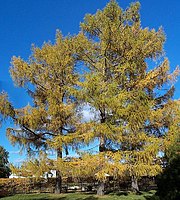
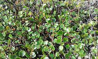
The paleo-environment changed across time.[20] Below is a gallery of mammoth steppe plants, the location where they have been identified as widespread, the time period and supporting citations.

Discovery Advances Efforts to Prevent Spread of Cancer

News   Jun 25, 2018 | Original story from University of Alberta
 
Discovery Advances Efforts to Prevent Spread of Cancer Oregon Health and Science University, Knight Cancer
Institute. NCI Visuals

Newly identified gene targets could be key to preventing the spread of cancer, new University of Alberta research has shown.

In a study published last week in Nature Communications, a team of U of A researchers said that because they’ve identified the appropriate genes, there’s potential to create therapies that could almost completely block metastasis in a number of deadly cancers.

“It’s of potentially incredible significance,” said John Lewis, the Alberta Cancer Foundation Frank and Carla Sojonky Chair in Prostate Cancer Research at the U of A and a member of the Cancer Research Institute of Northern Alberta (CRINA). “Metastasis kills 90 per cent of all patients who have cancer, and with this study we have discovered 11 new ways to potentially end metastasis.”

In the study, the team used a unique platform it created—a shell-less avian embryo—to visualize the growth and spread of cancer cells in real time. The researchers used a molecular tool called a knockout library to insert short hairpin RNA (shRNA) vectors into cancer cells that bound to specific genes in the cells and stopped them from activating. They then inserted those cancer cells into the shell-less embryos and observed as they formed clusters of cancer, identifying which ones showed properties of being non-metastatic.

“When we found compact colonies [of cancer], that meant that the key steps of metastasis were blocked,” said Konstantin Stoletov, lead author of the study and a research associate in the Lewis lab. “After that we could pull them out, query what the gene is and then validate that the gene is actually responsible for metastasis.”

The approach allowed the team to detect and identify 11 genes that play essential roles in cancer cell metastasis. According to the researchers, the genes discovered are widely involved in the process of metastasis and not unique to any one cancer.

They now plan to test the metastasis-associated genes and gene-products as drug targets with an aim of stopping metastasis.

“We know that cancer, once it becomes metastatic, will keep spreading to other parts of the body and continue to get worse because of that,” said Lewis. “If we can stop metastasis at any step of progression in cancer patients, we’re going to have a significant effect on survival.”

The team is now hoping to progress its research to human trials over the next few years. The Lewis lab is also expanding efforts to explore for other types of genes called microRNAs that may present even stronger therapeutic targets for preventing metastasis.

The research was funded by the Canadian Cancer Society and the Alberta Cancer Foundation.

Lewis and Stoletov’s paper, “Quantitative in vivo whole genome motility screen reveals novel therapeutic targets to block cancer metastasis,” was published June 14 in Nature Communications.

This article has been republished from materials provided by University of Alberta. Note: material may have been edited for length and content. For further information, please contact the cited source.

Butane

From Wikipedia, the free encyclopedia ...