Search This Blog

Wednesday, July 24, 2019

Ecoregion

From Wikipedia, the free encyclopedia
 
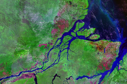
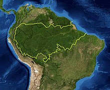
A map of the Amazon rainforest ecoregions. The yellow line encloses the ecoregions per the World Wide Fund for Nature.
 
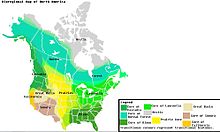
A map of North America's bioregions
 
An ecoregion (ecological region) is an ecologically and geographically defined area that is smaller than a bioregion, which in turn is smaller than an ecozone. All three of these are either less or greater than an ecosystem. Ecoregions cover relatively large areas of land or water, and contain characteristic, geographically distinct assemblages of natural communities and species. The biodiversity of flora, fauna and ecosystems that characterise an ecoregion tends to be distinct from that of other ecoregions. In theory, biodiversity or conservation ecoregions are relatively large areas of land or water where the probability of encountering different species and communities at any given point remains relatively constant, within an acceptable range of variation (largely undefined at this point). 

Three caveats are appropriate for all bio-geographic mapping approaches. Firstly, no single bio-geographic framework is optimal for all taxa. Ecoregions reflect the best compromise for as many taxa as possible. Secondly, ecoregion boundaries rarely form abrupt edges; rather, ecotones and mosaic habitats bound them. Thirdly, most ecoregions contain habitats that differ from their assigned biome. Biogeographic provinces may originate due to various barriers. Some physical (plate tectonics, topographic highs), some climatic (latitudinal variation, seasonal range) and some ocean chemical related (salinity, oxygen levels).

History

The history of the term is somewhat vague, and it had been used in many contexts: forest classifications (Loucks, 1962), biome classifications (Bailey, 1976, 2014), biogeographic classifications (WWF/Global 200 scheme of Olson & Dinerstein, 1998), etc.

The concept of ecoregion of Bailey gives more importance to ecological criteria, while the WWF concept gives more importance to biogeography, that is, distribution of distinct biotas.

Definition and categorization

The Ötztal Alps, a mountain range in the central Alps of Europe, are part of the Central Eastern Alps, and can both be termed as ecoregions.
 
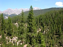
A conifer forest in the Swiss Alps (National Park).
 
An ecoregion is a "recurring pattern of ecosystems associated with characteristic combinations of soil and landform that characterise that region". Omernik (2004) elaborates on this by defining ecoregions as: "areas within which there is spatial coincidence in characteristics of geographical phenomena associated with differences in the quality, health, and integrity of ecosystems". "Characteristics of geographical phenomena" may include geology, physiography, vegetation, climate, hydrology, terrestrial and aquatic fauna, and soils, and may or may not include the impacts of human activity (e.g. land use patterns, vegetation changes). There is significant, but not absolute, spatial correlation among these characteristics, making the delineation of ecoregions an imperfect science. Another complication is that environmental conditions across an ecoregion boundary may change very gradually, e.g. the prairie-forest transition in the midwestern United States, making it difficult to identify an exact dividing boundary. Such transition zones are called ecotones.

Ecoregions can be categorized using an algorithmic approach or a holistic, "weight-of-evidence" approach where the importance of various factors may vary. An example of the algorithmic approach is Robert Bailey's work for the U.S. Forest Service, which uses a hierarchical classification that first divides land areas into very large regions based on climatic factors, and subdivides these regions, based first on dominant potential vegetation, and then by geomorphology and soil characteristics. The weight-of-evidence approach is exemplified by James Omernik's work for the United States Environmental Protection Agency, subsequently adopted (with modification) for North America by the Commission for Environmental Cooperation

The intended purpose of ecoregion delineation may affect the method used. For example, the WWF ecoregions were developed to aid in biodiversity conservation planning, and place a greater emphasis than the Omernik or Bailey systems on floral and faunal differences between regions. The WWF classification defines an ecoregion as:
A large area of land or water that contains a geographically distinct assemblage of natural communities that:
(a) Share a large majority of their species and ecological dynamics;
(b) Share similar environmental conditions, and;
(c) Interact ecologically in ways that are critical for their long-term persistence.
According to WWF, the boundaries of an ecoregion approximate the original extent of the natural communities prior to any major recent disruptions or changes. WWF has identified 867 terrestrial ecoregions, and approximately 450 freshwater ecoregions across the Earth. 

Terrestrial Ecoregions of the World (Olson et al. 2001, BioScience)

Importance

The use of the term ecoregion is an outgrowth of a surge of interest in ecosystems and their functioning. In particular, there is awareness of issues relating to spatial scale in the study and management of landscapes. It is widely recognized that interlinked ecosystems combine to form a whole that is "greater than the sum of its parts". There are many attempts to respond to ecosystems in an integrated way to achieve "multi-functional" landscapes, and various interest groups from agricultural researchers to conservationists are using the "ecoregion" as a unit of analysis. 

The "Global 200" is the list of ecoregions identified by WWF as priorities for conservation.

Ecologically based movements like bioregionalism maintain that ecoregions, rather than arbitrarily defined political boundaries, provide a better foundation for the formation and governance of human communities, and have proposed ecoregions and watersheds as the basis for bioregional democracy initiatives.

Terrestrial

WWF terrestrial ecoregions
 
Terrestrial ecoregions are land ecoregions, as distinct from freshwater and marine ecoregions. In this context, terrestrial is used to mean "of land" (soil and rock), rather than the more general sense "of Earth" (which includes land and oceans). 

WWF (World Wildlife Fund) ecologists currently divide the land surface of the Earth into 8 major ecozones containing 867 smaller terrestrial ecoregions. The WWF effort is a synthesis of many previous efforts to define and classify ecoregions. Many consider this classification to be quite decisive, and some propose these as stable borders for bioregional democracy initiatives.

The eight terrestrial ecozones follow the major floral and faunal boundaries, identified by botanists and zoologists, that separate the world's major plant and animal communities. Ecozone boundaries generally follow continental boundaries, or major barriers to plant and animal distribution, like the Himalayas and the Sahara. The boundaries of ecoregions are often not as decisive or well recognized, and are subject to greater disagreement.

Ecoregions are classified by biome type, which are the major global plant communities determined by rainfall and climate. Forests, grasslands (including savanna and shrubland), and deserts (including xeric shrublands) are distinguished by climate (tropical and subtropical vs. temperate and boreal climates) and, for forests, by whether the trees are predominantly conifers (gymnosperms), or whether they are predominantly broadleaf (Angiosperms) and mixed (broadleaf and conifer). Biome types like Mediterranean forests, woodlands, and scrub; tundra; and mangroves host very distinct ecological communities, and are recognized as distinct biome types as well.

Marine

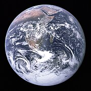
View of Earth, taken in 1972 by the Apollo 17 crew. Approximately 72% of the Earth's surface (an area of some 361 million square kilometers) consists of ocean.


Marine ecoregions are: "Areas of relatively homogeneous species composition, clearly distinct from adjacent systems….In ecological terms, these are strongly cohesive units, sufficiently large to encompass ecological or life history processes for most sedentary species." They have been defined by The Nature Conservancy (TNC) and World Wildlife Fund (WWF) to aid in conservation activities for marine ecosystems. Forty-three priority marine ecoregions were delineated as part of WWF's Global 200 efforts. The scheme used to designate and classify marine ecoregions is analogous to that used for terrestrial ecoregions. Major habitat types are identified: polar, temperate shelves and seas, temperate upwelling, tropical upwelling, tropical coral, pelagic (trades and westerlies), abyssal, and hadal (ocean trench). These correspond to the terrestrial biomes

The Global 200 classification of marine ecoregions is not developed to the same level of detail and comprehensiveness as that of the terrestrial ecoregions; only the priority conservation areas are listed.
See Global 200 Marine ecoregions for a full list of marine ecoregions.

In 2007, TNC and WWF refined and expanded this scheme to provide a system of comprehensive near shore (to 200 meters depth) Marine Ecoregions of the World (MEOW). The 232 individual marine ecoregions are grouped into 62 marine provinces, which in turn group into 12 marine realms, which represent the broad latitudinal divisions of polar, temperate, and tropical seas, with subdivisions based on ocean basins (except for the southern hemisphere temperate oceans, which are based on continents). 

Major biogeographic realms, analogous to the eight terrestrial ecozones, represent large regions of the ocean basins: Arctic, Temperate Northern Atlantic, Temperate Northern Pacific, Tropical Atlantic, Western Indo-Pacific, Central Indo-Pacific, Eastern Indo-Pacific, Tropical Eastern Pacific, Temperate South America, Temperate Southern Africa, Temperate Australasia, Southern Ocean.

A similar system of identifying areas of the oceans for conservation purposes is the system of large marine ecosystems (LMEs), developed by the US National Oceanic and Atmospheric Administration (NOAA).

Freshwater

 
A freshwater ecoregion is a large area encompassing one or more freshwater systems that contains a distinct assemblage of natural freshwater communities and species. The freshwater species, dynamics, and environmental conditions within a given ecoregion are more similar to each other than to those of surrounding ecoregions and together form a conservation unit. Freshwater systems include rivers, streams, lakes, and wetlands. Freshwater ecoregions are distinct from terrestrial ecoregions, which identify biotic communities of the land, and marine ecoregions, which are biotic communities of the oceans.

A map of Freshwater Ecoregions of the World, released in 2008, has 426 ecoregions covering virtually the entire non-marine surface of the earth.

World Wildlife Fund (WWF) identifies twelve major habitat types of freshwater ecoregions: Large lakes, large river deltas, polar freshwaters, montane freshwaters, temperate coastal rivers, temperate floodplain rivers and wetlands, temperate upland rivers, tropical and subtropical coastal rivers, tropical and subtropical floodplain rivers and wetlands, tropical and subtropical upland rivers, xeric freshwaters and endorheic basins, and oceanic islands. The freshwater major habitat types reflect groupings of ecoregions with similar biological, chemical, and physical characteristics and are roughly equivalent to biomes for terrestrial systems. 

The Global 200, a set of ecoregions identified by WWF whose conservation would achieve the goal of saving a broad diversity of the Earth's ecosystems, includes a number of areas highlighted for their freshwater biodiversity values. The Global 200 preceded Freshwater Ecoregions of the World and incorporated information from regional freshwater ecoregional assessments that had been completed at that time.
Savanna

From Wikipedia, the free encyclopedia

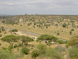
Typical tropical savanna in Northern Australia demonstrating the high tree density and regular spacing characteristic of many savannas
 
A savanna or savannah is a mixed woodland grassland ecosystem characterised by the trees being sufficiently widely spaced so that the canopy does not close. The open canopy allows sufficient light to reach the ground to support an unbroken herbaceous layer consisting primarily of grasses.

Savannas maintain an open canopy despite a high tree density. It is often believed that savannas feature widely spaced, scattered trees. However, in many savannas, tree densities are higher and trees are more regularly spaced than in forests. The South American savanna types cerrado sensu stricto and cerrado dense typically have densities of trees similar to or higher than that found in South American tropical forests, with savanna ranging from 800–3300 trees per hectare (trees/ha) and adjacent forests with 800–2000 trees/ha. Similarly Guinean savanna has 129 trees/ha, compared to 103 for riparian forest, while Eastern Australian sclerophyll forests have average tree densities of approximately 100 per hectare, comparable to savannas in the same region.

Savannas are also characterised by seasonal water availability, with the majority of rainfall confined to one season; they are associated with several types of biomes, and are frequently in a transitional zone between forest and desert or grassland. Savanna covers approximately 20% of the Earth's land area.

Etymology

The word originally entered English in 1555 as the Latin Zauana, equivalent in the orthography of the times to zavana (see history of V). Peter Martyr reported it as the local name for the plain around Comagre, the court of the cacique Carlos in present-day Panama. The accounts are inexact, but this is usually placed in present-day Madugandí or at points on the nearby Guna Yala coast opposite Ustupo or on Point Mosquitos. These areas are now either given over to modern cropland or jungle.

Distribution

 
Many grassy landscapes and mixed communities of trees, shrubs, and grasses were described as savanna before the middle of the 19th century, when the concept of a tropical savanna climate became established. The Köppen climate classification system was strongly influenced by effects of temperature and precipitation upon tree growth, and his oversimplified assumptions resulted in a tropical savanna classification concept which resulted in it being considered as a "climatic climax" formation. The common usage meaning to describe vegetation now conflicts with a simplified yet widespread climatic concept meaning. The divergence has sometimes caused areas such as extensive savannas north and south of the Congo and Amazon Rivers to be excluded from mapped savanna categories.

"Barrens" has been used almost interchangeably with savanna in different parts of North America. Sometimes midwestern savanna were described as "grassland with trees". Different authors have defined the lower limits of savanna tree coverage as 5–10% and upper limits range as 25–80% of an area.

Two factors common to all savanna environments are rainfall variations from year to year, and dry season wildfires. In the Americas, e.g. in Belize, Central America, savanna vegetation is similar from Mexico to South America and to the Caribbean.

Over many large tropical areas, the dominant biome (forest, savanna or grassland) can not be predicted only by the climate, as historical events plays also a key role, for example, fire activity. In some areas, indeed, it is possible the occurrence of multiple stable biomes.

Threats

Changes in fire management

Savannas are subject to regular wildfires and the ecosystem appears to be the result of human use of fire. For example, Native Americans created the Pre-Columbian savannas of North America by periodically burning where fire-resistant plants were the dominant species. Pine barrens in scattered locations from New Jersey to coastal New England are remnants of these savannas. Aboriginal burning appears to have been responsible for the widespread occurrence of savanna in tropical Australia and New Guinea, and savannas in India are a result of human fire use. The maquis shrub savannas of the Mediterranean region were likewise created and maintained by anthropogenic fire.

Prescribed burn; Wisconsin bur oak savanna
 
These fires are usually confined to the herbaceous layer and do little long term damage to mature trees. However, these fires either kill or suppress tree seedlings, thus preventing the establishment of a continuous tree canopy which would prevent further grass growth. Prior to European settlement aboriginal land use practices, including fire, influenced vegetation and may have maintained and modified savanna flora. It has been suggested by many authors that aboriginal burning created a structurally more open savanna landscape. Aboriginal burning certainly created a habitat mosaic that probably increased biodiversity and changed the structure of woodlands and geographic range of numerous woodland species. It has been suggested by many authors that with the removal or alteration of traditional burning regimes many savannas are being replaced by forest and shrub thickets with little herbaceous layer. 

The consumption of herbage by introduced grazers in savanna woodlands has led to a reduction in the amount of fuel available for burning and resulted in fewer and cooler fires. The introduction of exotic pasture legumes has also led to a reduction in the need to burn to produce a flush of green growth because legumes retain high nutrient levels throughout the year, and because fires can have a negative impact on legume populations which causes a reluctance to burn.

Grazing and browsing animals

The closed forest types such as broadleaf forests and rainforests are usually not grazed owing to the closed structure precluding grass growth, and hence offering little opportunity for grazing. In contrast the open structure of savannas allows the growth of a herbaceous layer and are commonly used for grazing domestic livestock. As a result, much of the world's savannas have undergone change as a result of grazing by sheep, goats and cattle, ranging from changes in pasture composition to woody weed encroachment.

The removal of grass by grazing affects the woody plant component of woodland systems in two major ways. Grasses compete with woody plants for water in the topsoil and removal by grazing reduces this competitive effect, potentially boosting tree growth. In addition to this effect, the removal of fuel reduces both the intensity and the frequency of fires which may control woody plant species. Grazing animals can have a more direct effect on woody plants by the browsing of palatable woody species. There is evidence that unpalatable woody plants have increased under grazing in savannas. Grazing also promotes the spread of weeds in savannas by the removal or reduction of the plants which would normally compete with potential weeds and hinder establishment. In addition to this, cattle and horses are implicated in the spread of the seeds of weed species such as Prickly Acacia (Acacia nilotica) and Stylo (Stylosanthes spp.). Alterations in savanna species composition brought about by grazing can alter ecosystem function, and are exacerbated by overgrazing and poor land management practices.

Introduced grazing animals can also affect soil condition through physical compaction and break-up of the soil caused by the hooves of animals and through the erosion effects caused by the removal of protective plant cover. Such effects are most likely to occur on land subjected to repeated and heavy grazing. The effects of overstocking are often worst on soils of low fertility and in low rainfall areas below 500 mm, as most soil nutrients in these areas tend to be concentrated in the surface so any movement of soils can lead to severe degradation. Alteration in soil structure and nutrient levels affects the establishment, growth and survival of plant species and in turn can lead to a change in woodland structure and composition.

Tree clearing

Large areas of Australian and South American savannas have been cleared of trees, and this clearing is continuing today. For example, until recently 480,000 ha of savanna were cleared annually in Australia alone primarily to improve pasture production. Substantial savanna areas have been cleared of woody vegetation and much of the area that remains today is vegetation that has been disturbed by either clearing or thinning at some point in the past. 

Clearing is carried out by the grazing industry in an attempt to increase the quality and quantity of feed available for stock and to improve the management of livestock. The removal of trees from savanna land removes the competition for water from the grasses present, and can lead to a two to fourfold increase in pasture production, as well as improving the quality of the feed available. Since stock carrying capacity is strongly correlated with herbage yield, there can be major financial benefits from the removal of trees, such as assisting with grazing management: regions of dense tree and shrub cover harbors predators, leading to increased stock losses, for example, while woody plant cover hinders mustering in both sheep and cattle areas.

A number of techniques have been employed to clear or kill woody plants in savannas. Early pastoralists used felling and girdling, the removal of a ring of bark and sapwood, as a means of clearing land. In the 1950s arboricides suitable for stem injection were developed. War-surplus heavy machinery was made available, and these were used for either pushing timber, or for pulling using a chain and ball strung between two machines. These two new methods of timber control, along with the introduction and widespread adoption of several new pasture grasses and legumes promoted a resurgence in tree clearing. The 1980s also saw the release of soil-applied arboricides, notably tebuthiuron, that could be utilised without cutting and injecting each individual tree.

In many ways "artificial" clearing, particularly pulling, mimics the effects of fire and, in savannas adapted to regeneration after fire as most Queensland savannas are, there is a similar response to that after fire. Tree clearing in many savanna communities, although causing a dramatic reduction in basal area and canopy cover, often leaves a high percentage of woody plants alive either as seedlings too small to be affected or as plants capable of re-sprouting from lignotubers and broken stumps. A population of woody plants equal to half or more of the original number often remains following pulling of eucalypt communities, even if all the trees over 5 metres are uprooted completely.

Exotic plant species

 
A number of exotic plants species have been introduced to the savannas around the world. Amongst the woody plant species are serious environmental weeds such as Prickly Acacia (Acacia nilotica), Rubbervine (Cryptostegia grandiflora), Mesquite (Prosopis spp.), Lantana (Lantana camara and L. montevidensis) and Prickly Pear (Opuntia spp.) A range of herbaceous species have also been introduced to these woodlands, either deliberately or accidentally including Rhodes grass and other Chloris species, Buffel grass (Cenchrus ciliaris), Giant rat's tail grass (Sporobolus pyramidalis) parthenium (Parthenium hysterophorus) and stylos (Stylosanthes spp.) and other legumes. These introductions have the potential to significantly alter the structure and composition of savannas worldwide, and have already done so in many areas through a number of processes including altering the fire regime, increasing grazing pressure, competing with native vegetation and occupying previously vacant ecological niches. Other plant species include: white sage, spotted cactus, cotton seed, rosemary.

Climate change

Human induced climate change resulting from the greenhouse effect may result in an alteration of the structure and function of savannas. Some authors have suggested that savannas and grasslands may become even more susceptible to woody plant encroachment as a result of greenhouse induced climate change. However, a recent case described a savanna increasing its range at the expense of forest in response to climate variation, and potential exists for similar rapid, dramatic shifts in vegetation distribution as a result of global climate change, particularly at ecotones such as savannas so often represent.

Savanna ecoregions

Mediterranean savanna in Alentejo region, Portugal
 
Savanna ecoregions are of several different types:

Rainforest

From Wikipedia, the free encyclopedia

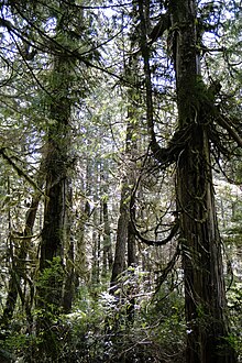
A view of Kitlope Lake in the Kitlope Heritage Conservancy.
 
Rainforests are forests characterized by high rainfall, with annual rainfall in the case of tropical rainforests between 250 and 450 centimetres (98 and 177 in), and definitions varying by region for temperate rainforests. The monsoon trough, alternatively known as the intertropical convergence zone, plays a significant role in creating the climatic conditions necessary for the Earth's tropical rainforests. 

Around 40% to 75% of all biotic species are indigenous to the rainforests. There may be many millions of species of plants, insects and microorganisms still undiscovered in tropical rainforests. Tropical rainforests have been called the "jewels of the Earth" and the "world's largest pharmacy", because over one quarter of natural medicines have been discovered there. Rainforests are also responsible for 28% of the world's oxygen turnover, sometimes misnamed oxygen production, processing it through photosynthesis from carbon dioxide and consuming it through respiration.
The undergrowth in some areas of a rainforest can be restricted by poor penetration of sunlight to ground level. If the leaf canopy is destroyed or thinned, the ground beneath is soon colonized by a dense, tangled growth of vines, shrubs and small trees, called a jungle. The term jungle is also sometimes applied to tropical rainforests generally. 

Rainforests as well as endemic rainforest species are rapidly disappearing due to deforestation, the resulting habitat loss and pollution of the atmosphere.

Tropical

Worldwide tropical rainforest climate zones.
 
Tropical rainforests are characterized by a warm and wet climate with no substantial dry season: typically found within 10 degrees north and south of the equator. Mean monthly temperatures exceed 18 °C (64 °F) during all months of the year. Average annual rainfall is no less than 168 cm (66 in) and can exceed 1,000 cm (390 in) although it typically lies between 175 cm (69 in) and 200 cm (79 in).

Many of the world's tropical forests are associated with the location of the monsoon trough, also known as the intertropical convergence zone. The broader category of tropical moist forests are located in the equatorial zone between the Tropic of Cancer and Tropic of Capricorn. Tropical rainforests exist in Southeast Asia (from Myanmar (Burma)) to the Philippines, Malaysia, Indonesia, Papua New Guinea and Sri Lanka; also in Sub-Saharan Africa from the Cameroon to the Congo (Congo Rainforest), South America (e.g. the Amazon rainforest), Central America (e.g. Bosawás, the southern Yucatán Peninsula-El Peten-Belize-Calakmul), Australia, and on Pacific Islands (such as Hawaiʻi). Tropical forests have been called the "Earth's lungs", although it is now known that rainforests contribute little net oxygen addition to the atmosphere through photosynthesis.

Temperate

General distribution of temperate rainforests
 
Tropical forests cover a large part of the globe, but temperate rainforests only occur in few regions around the world. Temperate rainforests are rainforests in temperate regions. They occur in North America (in the Pacific Northwest in Alaska, British Columbia, Washington, Oregon and California), in Europe (parts of the British Isles such as the coastal areas of Ireland and Scotland, southern Norway, parts of the western Balkans along the Adriatic coast, as well as in Galicia and coastal areas of the eastern Black Sea, including Georgia and coastal Turkey), in East Asia (in southern China, Highlands of Taiwan, much of Japan and Korea, and on Sakhalin Island and the adjacent Russian Far East coast), in South America (southern Chile) and also in Australia and New Zealand.

Layers

A tropical rainforest typically has a number of layers, each with different plants and animals adapted for life in that particular area. Examples include the emergent, canopy, understory and forest floor layers.

Emergent layer

The emergent layer contains a small number of very large trees called emergents, which grow above the general canopy, reaching heights of 45–55 m, although on occasion a few species will grow to 70–80 m tall. They need to be able to withstand the hot temperatures and strong winds that occur above the canopy in some areas. Eagles, butterflies, bats and certain monkeys inhabit this layer. 

Canopy layer

The canopy layer contains the majority of the largest trees, typically 30 metres (98 ft) to 45 metres (148 ft) tall. The densest areas of biodiversity are found in the forest canopy, a more or less continuous cover of foliage formed by adjacent treetops. The canopy, by some estimates, is home to 50 percent of all plant species. Epiphytic plants attach to trunks and branches, and obtain water and minerals from rain and debris that collects on the supporting plants. The fauna is similar to that found in the emergent layer, but more diverse. A quarter of all insect species are believed to exist in the rainforest canopy. Scientists have long suspected the richness of the canopy as a habitat, but have only recently developed practical methods of exploring it. As long ago as 1917, naturalist William Beebe declared that "another continent of life remains to be discovered, not upon the Earth, but one to two hundred feet above it, extending over thousands of square miles." True exploration of this habitat only began in the 1980s, when scientists developed methods to reach the canopy, such as firing ropes into the trees using crossbows. Exploration of the canopy is still in its infancy, but other methods include the use of balloons and airships to float above the highest branches and the building of cranes and walkways planted on the forest floor. The science of accessing tropical forest canopy using airships or similar aerial platforms is called dendronautics.

Understory layer

The understory or understorey layer lies between the canopy and the forest floor. It is home to a number of birds, snakes and lizards, as well as predators such as jaguars, boa constrictors and leopards. The leaves are much larger at this level and insect life is abundant. Many seedlings that will grow to the canopy level are present in the understory. Only about 5% of the sunlight shining on the rainforest canopy reaches the understory. This layer can be called a shrub layer, although the shrub layer may also be considered a separate layer.

Forest floor

Rainforest in the Blue Mountains, Australia
 
The forest floor, the bottom-most layer, receives only 2% of the sunlight. Only plants adapted to low light can grow in this region. Away from riverbanks, swamps and clearings, where dense undergrowth is found, the forest floor is relatively clear of vegetation because of the low sunlight penetration. It also contains decaying plant and animal matter, which disappears quickly, because the warm, humid conditions promote rapid decay. Many forms of fungi growing here help decay the animal and plant waste.

Flora and fauna

More than half of the world's species of plants and animals are found in the rainforest. Rainforests support a very broad array of fauna, including mammals, reptiles, birds and invertebrates. Mammals may include primates, felids and other families. Reptiles include snakes, turtles, chameleons and other families; while birds include such families as vangidae and Cuculidae. Dozens of families of invertebrates are found in rainforests. Fungi are also very common in rainforest areas as they can feed on the decomposing remains of plants and animals.

The great diversity in rainforest species is in large part the result of diverse and numerous physical refuges, i.e. places in which plants are inaccessible to many herbivores, or in which animals can hide from predators. Having numerous refuges available also results in much higher total biomass than would otherwise be possible.

Soils

Despite the growth of vegetation in a tropical rainforest, soil quality is often quite poor. Rapid bacterial decay prevents the accumulation of humus. The concentration of iron and aluminium oxides by the laterization process gives the oxisols a bright red colour and sometimes produces mineral deposits such as bauxite. Most trees have roots near the surface, because there are insufficient nutrients below the surface; most of the trees' minerals come from the top layer of decomposing leaves and animals. On younger substrates, especially of volcanic origin, tropical soils may be quite fertile. If rainforest trees are cleared, rain can accumulate on the exposed soil surfaces, creating run-off and beginning a process of soil erosion. Eventually streams and rivers form and flooding becomes possible. There are several reasons for the poor soil quality: First is that the soil is highly acidic. The roots of plants rely on an acidity difference between the roots and the soil in order to absorb nutrients. When the soil is acidic, there is little difference, and therefore little absorption of nutrients from the soil. Second, The type of clay particles present in tropical rainforest soil has a poor ability to trap nutrients and stop them from washing away. Even if humans artificially add nutrients to the soil, the nutrients mostly wash away and are not absorbed by the plants. Thirdly, The type of clay particles present in tropical rainforest soil has a poor ability to trap nutrients and stop them from washing away. Even if humans artificially add nutrients to the soil, the nutrients mostly wash away and are not absorbed by the plants. Finally, these soils are poor due to the high volume of rain in tropical rainforests washes nutrients out of the soil more quickly than in other climates.

Effect on global climate

A natural rainforest emits and absorbs vast quantities of carbon dioxide. On a global scale, long-term fluxes are approximately in balance, so that an undisturbed rainforest would have a small net impact on atmospheric carbon dioxide levels, though they may have other climatic effects (on cloud formation, for example, by recycling water vapour). No rainforest today can be considered to be undisturbed. Human-induced deforestation plays a significant role in causing rainforests to release carbon dioxide, as do other factors, whether human-induced or natural, which result in tree death, such as burning and drought. Some climate models operating with interactive vegetation predict a large loss of Amazonian rainforest around 2050 due to drought, forest dieback and the subsequent release of more carbon dioxide. Five million years from now, the Amazon rainforest may long since have dried and transformed itself into savannah, killing itself in the progress (changes such as this may happen even if all human deforestation activity ceases overnight).

Human uses

Aerial view of the Amazon rainforest, taken from a plane.

Tropical rainforests provide timber as well as animal products such as meat and hides. Rainforests also have value as tourism destinations and for the ecosystem services provided. Many foods originally came from tropical forests, and are still mostly grown on plantations in regions that were formerly primary forest. Also, plant-derived medicines are commonly used for fever, fungal infections, burns, gastrointestinal problems, pain, respiratory problems, and wound treatment. At the same time, rainforests are usually not used sustainably by non-native peoples but are being exploited or removed for agricultural purposes.

Native peoples

On January 18, 2007, FUNAI reported also that it had confirmed the presence of 67 different uncontacted tribes in Brazil, up from 40 in 2005. With this addition, Brazil has now overtaken the island of New Guinea as the country having the largest number of uncontacted tribes. The province of Irian Jaya or West Papua in the island of New Guinea is home to an estimated 44 uncontacted tribal groups. The tribes are in danger because of the deforestation, especially in Brazil. 

Central African rainforest is home of the Mbuti pygmies, one of the hunter-gatherer peoples living in equatorial rainforests characterised by their short height (below one and a half metres, or 59 inches, on average). They were the subject of a study by Colin Turnbull, The Forest People, in 1962. Pygmies who live in Southeast Asia are, amongst others, referred to as “Negrito”. There are many tribes in the rainforests of the Malaysian state of Sarawak. Sarawak is part of Borneo, the third largest island in the world. Some of the other tribes in Sarawak are: the Kayan, Kenyah, Kejaman, Kelabit, Punan Bah, Tanjong, Sekapan, and the Lahanan. Collectively, they are referred to as Dayaks or Orangulu which means "people of the interior".

About half of Sarawak's 1.5 million people are Dayaks. Most Dayaks, it is believed thropologists, came originally from the South-East Asian mainland. Their mythologies support this

Deforestation

Satellite photograph of the haze above Borneo and Sumatra on 24 September 2015.
 
Tropical and temperate rainforests have been subjected to heavy legal and illegal logging for their valuable hardwoods and agricultural clearance (slash-and-burn, clearcutting) throughout the 20th century and the area covered by rainforests around the world is shrinking. Biologists have estimated that large numbers of species are being driven to extinction (possibly more than 50,000 a year; at that rate, says E. O. Wilson of Harvard University, a quarter or more of all species on Earth could be exterminated within 50 years) due to the removal of habitat with destruction of the rainforests.

Another factor causing the loss of rainforest is expanding urban areas. Littoral rainforest growing along coastal areas of eastern Australia is now rare due to ribbon development to accommodate the demand for seachange lifestyles.

Forests are being destroyed at a rapid pace. Almost 90% of West Africa's rainforest has been destroyed. Since the arrival of humans, Madagascar has lost two thirds of its original rainforest. At present rates, tropical rainforests in Indonesia would be logged out in 10 years and Papua New Guinea in 13 to 16 years. According to Rainforest Rescue, an important reason for the increasing deforestation rate, especially in Indonesia, is the expansion of oil palm plantations to meet growing demand for cheap vegetable fats and biofuels. In Indonesia, palm oil is already cultivated on nine million hectares and, together with Malaysia, the island nation produces about 85 percent of the world's palm oil.

Several countries, notably Brazil, have declared their deforestation a national emergency. Amazon deforestation jumped by 69% in 2008 compared to 2007's twelve months, according to official government data.

However, a January 30, 2009 New York Times article stated, "By one estimate, for every acre of rain forest cut down each year, more than 50 acres of new forest are growing in the tropics..." The new forest includes secondary forest on former farmland and so-called degraded forest.

World Wide Web Consortium

From Wikipedia, the free encyclopedia https://en.wikipedia.org/wiki/World_Wide_Web_Consortium World Wide We...