Search This Blog

Friday, April 2, 2021

Tipping points in the climate system

Possible tipping elements in the climate system.
 
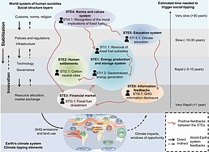
Interactions of climate tipping points (bottom) with associated tipping points in the socioeconomic system (top) on different time scales. 

A tipping point in the climate system is a threshold that, when exceeded, can lead to large changes in the state of the system. Potential tipping points have been identified in the physical climate system, in impacted ecosystems, and sometimes in both. For instance, feedback from the global carbon cycle is a driver for the transition between glacial and interglacial periods, with orbital forcing providing the initial trigger. Earth's geologic temperature record includes many more examples of geologically rapid transitions between different climate states.

Climate tipping points are of particular interest in reference to concerns about global warming in the modern era. Possible tipping point behaviour has been identified for the global mean surface temperature by studying self-reinforcing feedbacks and the past behavior of Earth's climate system. Self-reinforcing feedbacks in the carbon cycle and planetary reflectivity could trigger a cascading set of tipping points that lead the world into a hothouse climate state.

Large-scale components of the Earth system that may pass a tipping point have been referred to as tipping elements. Tipping elements are found in the Greenland and Antarctic ice sheets, possibly causing tens of meters of sea level rise. These tipping points are not always abrupt. For example, at some level of temperature rise the melt of a large part of the Greenland ice sheet and/or West Antarctic Ice Sheet will become inevitable; but the ice sheet itself may persist for many centuries. Some tipping elements, like the collapse of ecosystems, are irreversible.

Definition

The IPCC AR5 defines a tipping point as an irreversible change in the climate system. It states that the precise levels of climate change sufficient to trigger a tipping point remain uncertain, but that the risk associated with crossing multiple tipping points increases with rising temperature. A broader definition of tipping points is sometimes used as well, which includes abrupt but reversible tipping points.

In the context of climate change, an "adaptation tipping point" has been defined as "the threshold value or specific boundary condition where ecological, technical, economic, spatial or socially acceptable limits are exceeded."

Tipping point behaviour in the climate can also be described in mathematical terms. Tipping points are then seen as any type of bifurcation with hysteresis. Hysteresis is the dependence of the state of a system on its history. For instance, depending on how warm and cold it was in the past, there can be differing amounts of ice present on the poles at the same concentration of greenhouse gases or temperature.

In a study inspired by "mathematical and statistical approaches to climate modelling and prediction", the authors identify three types of tipping points in open systems such as the climate system—bifurcation, noise-induced and rate-dependent. The idea of tipping points in climate science, as indicated by palaeoclimate data and global climate models, suggest that the "climate system may abruptly 'tip' from one regime to another in a comparatively short time."

Bifurcation-induced tipping refers to changes in dynamical systems that occur when a small smooth change made to bifurcation parameters of the system causes an abrupt or sudden topological change in the behavior of the system. In the Atlantic Meridional Overturning Circulation (AMOC), slow passage to the bifurcation parameters—the salinity, temperature and density of water—could cause the AMOC to abruptly collapse when it reaches a critical tipping point. Currents of warm, seawater in the upper layers of the Atlantic flow north, while currents of colder, deep waters from the North Atlantic flow south, like a conveyor belt known as thermohaline circulation. Downwelling occurs when the warmer, higher-density seawater accumulates and sinks beneath the colder, lower density less saline water from glacier melt. An AMOC collapse would occur if downwelling was inhibited. [critical slowing down] (CSD) "occurs because a restoring feedback is weakening as a bifurcation-type tipping point is approached."

Noise-induced tipping refers to transitions due to random fluctuations or internal variability of the system, as in the Dansgaard-Oeschger events during the last glacial period, with 25 occurrences of rapid climate fluctuations.

Rate-induced tipping occurs in an "excitable system"—such as peatlands—when one of the systems parameters is "ramped" through a "steady, slow and monotonic change" eliciting a "large excitable response". In the case of peatlands, the rate-induced tipping point results in an "explosive release of soil carbon from peatlands into the atmosphere"—"compost bomb instability".

Tipping points for global temperature

There are many positive and negative feedbacks to global temperatures and the carbon cycle that have been identified. The IPCC reports that feedbacks to increased temperatures are net positive for the remainder of this century, with the impact of cloud cover the largest uncertainty. IPCC carbon cycle models show higher ocean uptake of carbon corresponding to higher concentration pathways, but land carbon uptake is uncertain due to the combined effect of climate change and land use changes.

The geologic record of temperature and greenhouse gas concentration allows climate scientists to gather information on climate feedbacks that lead to different climate states, such as the Late Quaternary (past 1.2 million years), the Pliocene period five million years ago and the Cretaceous period, 100 million years ago. Combining this information with the understanding of current climate change resulted in the finding that "A 2 °C warming could activate important tipping elements, raising the temperature further to activate other tipping elements in a domino-like cascade that could take the Earth System to even higher temperatures".

The speed of tipping point feedbacks is a critical concern and the geologic record often fails to provide clarity as to whether past temperature changes have taken only a few decades or many millennia of time. For instance, a tipping point that was once feared to be abrupt and overwhelming is the release of clathrate compounds buried in seabeds and seabed permafrost, but that feedback is now thought to be chronic and long term.

Some individual feedbacks may be strong enough to trigger tipping points on their own. A 2019 study predicts that if greenhouse gases reach three times the current level of atmospheric carbon dioxide that stratocumulus clouds could abruptly disperse, contributing an additional 8 degrees Celsius of warming.

Runaway greenhouse effect

The runaway greenhouse effect is used in astronomical circles to refer to a greenhouse effect that is so extreme that oceans boil away and render a planet uninhabitable, an irreversible climate state that happened on Venus. The IPCC Fifth Assessment Report states that "a 'runaway greenhouse effect' —analogous to Venus— appears to have virtually no chance of being induced by anthropogenic activities." Venus-like conditions on the Earth require a large long-term forcing that is unlikely to occur until the sun brightens by a few tens of percents, which will take a few billion years.

While a runaway greenhouse effect on Earth is virtually impossible, there are indications that Earth could enter a moist greenhouse state that renders large parts of Earth uninhabitable if the climate forcing is large enough to make water vapour (H2O) a major atmospheric constituent. Conceivable levels of human-made climate forcing would increase water vapour to about 1% of the atmosphere's mass, thus increasing the rate of hydrogen escape to space. If such a forcing were entirely due to CO2, the weathering process would remove the excess atmospheric CO2 well before the ocean was significantly depleted.

Tipping elements

Large scale tipping elements

A smooth or abrupt change in temperature can trigger global-scale tipping points. In the cryosphere these include the irreversible melting of Greenland and Antarctic ice sheets. In Greenland, a positive feedback cycle exists between melting and surface elevation. At lower elevations, temperatures are higher, leading to additional melting. This feedback loop can become so strong that irreversible melting occurs. Marine ice sheet instability could trigger a tipping point in West Antarctica. Crossing either of these tipping points leads to accelerated global sea level rise.

When fresh water gets released as a consequence of Greenland melting, a threshold may be crossed which leads to disruption of the thermohaline circulation. The thermohaline circulation transports heat northward which is important for temperature regulation in the Atlantic region. Risks for a complete shutdown are low to moderate under the Paris agreement levels of warming.

Other examples of possible large scale tipping elements are a shift in El Niño–Southern Oscillation. After crossing a tipping point, the warm phase (El Niño) would start to occur more often. Lastly, the southern ocean, which now absorbs a lot of carbon, might switch to a state where it does not do this anymore.

Regional tipping elements

Climate change can trigger regional tipping points as well. Examples are the disappearance of Arctic sea ice, the establishment of woody species in tundra, permafrost loss, the collapse of the monsoon of South Asia and a strengthening of the West African monsoon which would lead to greening of the Sahara and Sahel. Deforestation may trigger a tipping point in rainforests (i.e. Savannization in the Amazon rainforest, ...). As rain forests recycle a large part of their rainfall, when a portion of the forest is destroyed local droughts may threaten the remainder. Finally, boreal forests are considered a tipping element as well. Local warming causes trees to die at a higher rate than before, in proportion to the rise in temperature. As more trees die, the woodland becomes more open, leading to further warming and making forests more susceptible to fire. The tipping point is difficult to predict, but is estimated to be between 3–4 °C of global temperature rise.

Cascading tipping points

Crossing a threshold in one part of the climate system may trigger another tipping element to tip into a new state. These are so-called cascading tipping points. Ice loss in West Antarctica and Greenland will significantly alter ocean circulation. Sustained warming of the northern high latitudes as a result of this process could activate tipping elements in that region, such as permafrost degradation, loss of Arctic sea ice, and Boreal forest dieback. This illustrates that even at relatively low levels of global warming, relatively stable tipping elements may be activated.

Timothy Lenton at Exeter University, England and his team of researchers, had first warned in their landmark 7 February 2008 PNAS paper, about the "risks of climate tipping points." In 2008, Lenton and his team "thought the dangers would only arise when global warming exceeded 5 degrees Celsius (9 degrees Fahrenheit) above pre-industrial levels." A new study published in Nature on 27 November 2019 by Lenton and 6 co-authors, warned in language that is "much starker" than the Intergovernmental Panel on Climate Change's forecasts, that risks are "much more likely and much more imminent" and that some "may already have been breached."

Early warning signals

For some of the tipping points described above, it may be possible to detect whether that part of the climate system is getting closer to a tipping point; however, detection can note only that abrupt changes are likely, while predicting when and where they will occur remains difficult. A premier mode of detection for these warning signals is through natural archives like sediments, ice caps, and tree rings, where past changes in climate can be observed. All parts of the climate system are sometimes disturbed by weather events. After the disruption, the system moves back to its equilibrium. A storm may damage sea ice, which grows back after the storm has passed. If a system is getting closer to tipping, this restoration to its normal state might take increasingly longer, which can be used as a warning sign of tipping.

Changes in the Arctic

A 2019 UNEP study indicates that now at least for the Arctic and the Greenland ice sheet a tipping point has already been reached. Because of dewing of permafrost soil, more methane (in addition to other short-lived climate pollutant) could enter the atmosphere earlier than previously predicted and the loss of reflecting ice shields has started a powerful positive feedback loop leading to ever higher temperatures. The resulting accelerating climate instability in the polar region has potential to affect the global climate, outdating previous predictions about the point in the future when global tipping will occur.

A more regional tipping point may have already been reached in the form of a mass recession of Arctic sea ice. According to scientist Ron Lindsay at the University of Washington Applied Physics Laboratory, a tipping point in the Arctic materializes as a positive feedback loop, where "increased summer melt means decreased winter growth and then even more melting the next summer, and so on." The loss of Arctic sea ice, while detrimental to the region, also holds severe consequences for the rest of the globe. Critically important is the role of sea ice in increasing the Earth's albedo, or reflectivity. Sea ice has an albedo level of 0.5 to 0.7, reflecting fifty to seventy percent of incoming energy, while the ocean beneath has an albedo of only .06, reflecting only six percent of incoming energy. As sea ice decreases and exposes the less reflective ocean, albedo decreases across the region. Summer sea ice is of particular importance, reflecting approximately fifty percent of incoming radiation back into space at a time when there is already an increase in daylight in the Arctic. NOAA (National Oceanic and Atmospheric Administration) notes that in September 2019, "the sea ice cover reached its annual summer minimum, tying with 2007 and 2016 for second-smallest on record."

In June 2019, satellite images from around the Arctic showed burning fires that are farther north and of greater magnitude than at any time in the 16-year satellite record, and some of the fires appear to have ignited peat soils. Peat is an accumulation of partially decayed vegetation and is an efficient carbon sink. Scientists are concerned because the long-lasting peat fires release their stored carbon back to the atmosphere, contributing to further warming. The fires in June 2019, for example, released as much carbon dioxide as Sweden's annual greenhouse gas emissions.

Tipping point effects

If the climate tips into a hothouse Earth scenario, some scientists warn of food and water shortages, hundreds of millions of people being displaced by rising sea levels, unhealthy and unlivable conditions, and coastal storms having larger impacts. Runaway climate change of 4–5 °C can make swathes of the planet around the equator uninhabitable, with sea levels up to 60 metres (197 ft) higher than they are today. Humans cannot survive if the air is too moist and hot, which would happen for the majority of human populations if global temperatures rise by 11–12 °C, as land masses warm faster than the global average. Effects like these have been popularized in books like The Uninhabitable Earth and The End of Nature.

Abrupt climate change

From Wikipedia, the free encyclopedia
Jump to navigation Jump to search
Clathrate hydrates have been identified as a possible agent for abrupt changes.

An abrupt climate change occurs when the climate system is forced to transition to a new climate state at a rate that is determined by the climate system energy-balance, and which is more rapid than the rate of change of the external forcing. Past events include the end of the Carboniferous Rainforest Collapse, Younger Dryas, Dansgaard-Oeschger events, Heinrich events and possibly also the Paleocene–Eocene Thermal Maximum. The term is also used within the context of global warming to describe sudden climate change that is detectable over the time-scale of a human lifetime, possibly as the result of feedback loops within the climate system.

Timescales of events described as 'abrupt' may vary dramatically. Changes recorded in the climate of Greenland at the end of the Younger Dryas, as measured by ice-cores, imply a sudden warming of +10 °C (+18 °F) within a timescale of a few years. Other abrupt changes are the +4 °C (+7.2 °F) on Greenland 11,270 years ago or the abrupt +6 °C (11 °F) warming 22,000 years ago on Antarctica. By contrast, the Paleocene-Eocene thermal maximum may have initiated anywhere between a few decades and several thousand years. Finally, Earth Systems models project that under ongoing greenhouse gas emissions as early as 2047, the Earth's near surface temperature could depart from the range of variability in the last 150 years, affecting over 3 billion people and most places of great species diversity on Earth.

Definitions

According to the Committee on Abrupt Climate Change of the National Research Council:

There are essentially two definitions of abrupt climate change:

  • In terms of physics, it is a transition of the climate system into a different mode on a time scale that is faster than the responsible forcing.
  • In terms of impacts, "an abrupt change is one that takes place so rapidly and unexpectedly that human or natural systems have difficulty adapting to it".

These definitions are complementary: the former gives some insight into how abrupt climate change comes about; the latter explains why there is so much research devoted to it.

General

Possible tipping elements in the climate system include regional effects of global warming, some of which had abrupt onset and may therefore be regarded as abrupt climate change. Scientists have stated, "Our synthesis of present knowledge suggests that a variety of tipping elements could reach their critical point within this century under anthropogenic climate change".

It has been postulated that teleconnections, oceanic and atmospheric processes, on different timescales, connect both hemispheres during abrupt climate change.

The IPCC states that global warming "could lead to some effects that are abrupt or irreversible".

A 2013 report from the U.S. National Research Council called for attention to the abrupt impacts of climate change, stating that even steady, gradual change in the physical climate system can have abrupt impacts elsewhere, such as in human infrastructure and ecosystems if critical thresholds are crossed. The report emphasizes the need for an early warning system that could help society better anticipate sudden changes and emerging impacts.

Scientific understanding of abrupt climate change is generally poor. The probability of abrupt change for some climate related feedbacks may be low. Factors that may increase the probability of abrupt climate change include higher magnitudes of global warming, warming that occurs more rapidly and warming that is sustained over longer time periods.

Climate models

Climate models are currently unable to predict abrupt climate change events, or most of the past abrupt climate shifts. A potential abrupt feedback due to thermokarst lake formations in the Arctic, in response to thawing permafrost soils, releasing additional greenhouse gas methane, is currently not accounted for in climate models.

Possible precursor

Most abrupt climate shifts are likely due to sudden circulation shifts, analogous to a flood cutting a new river channel. The best-known examples are the several dozen shutdowns of the North Atlantic Ocean's Meridional Overturning Circulation during the last ice age, affecting climate worldwide.

  • The current warming of the Arctic, the duration of the summer season, is considered abrupt and massive.
  • Antarctic ozone depletion caused significant atmospheric circulation changes.
  • There have also been two occasions when the Atlantic's Meridional Overturning Circulation lost a crucial safety factor. The Greenland Sea flushing at 75 °N shut down in 1978, recovering over the next decade. Then the second-largest flushing site, the Labrador Sea, shut down in 1997 for ten years. While shutdowns overlapping in time have not been seen during the 50 years of observation, previous total shutdowns had severe worldwide climate consequences.

Effects

A summary of the path of the thermohaline circulation. Blue paths represent deep-water currents, and red paths represent surface currents.
 
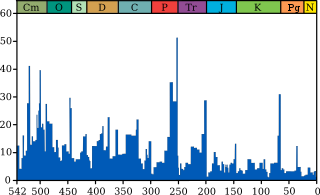
The Permian–Triassic extinction event, labelled "P-Tr" here, is the most significant extinction event in this plot for marine genera.

Abrupt climate change has likely been the cause of wide-ranging and severe effects:

Climate feedback effects

The dark ocean surface reflects only 6 percent of incoming solar radiation; sea ice reflects 50 to 70 percent.

One source of abrupt climate change effects is a feedback process, in which a warming event causes a change that adds to further warming. The same can apply to cooling. Examples of such feedback processes are:

Volcanism

Isostatic rebound in response to glacier retreat (unloading) and increased local salinity have been attributed to increased volcanic activity at the onset of the abrupt Bølling-Allerød warming. They are associated with the interval of intense volcanic activity, hinting at an interaction between climate and volcanism: enhanced short-term melting of glaciers, possibly via albedo changes from particle fallout on glacier surfaces.

Past events

The Younger Dryas period of abrupt climate change is named after the Alpine flower, Dryas.

Several periods of abrupt climate change have been identified in the paleoclimatic record. Notable examples include:

  • About 25 climate shifts, called Dansgaard-Oeschger cycles, which have been identified in the ice core record during the glacial period over the past 100,000 years.
  • The Younger Dryas event, notably its sudden end. It is the most recent of the Dansgaard-Oeschger cycles and began 12,900 years ago and moved back into a warm-and-wet climate regime about 11,600 years ago. It has been suggested that "the extreme rapidity of these changes in a variable that directly represents regional climate implies that the events at the end of the last glaciation may have been responses to some kind of threshold or trigger in the North Atlantic climate system." A model for this event based on disruption to the thermohaline circulation has been supported by other studies.
  • The Paleocene-Eocene Thermal Maximum, timed at 55 million years ago, which may have been caused by the release of methane clathrates, although potential alternative mechanisms have been identified. This was associated with rapid ocean acidification
  • The Permian–Triassic Extinction Event, in which up to 95% of all species became extinct, has been hypothesized to be related to a rapid change in global climate. Life on land took 30 million years to recover.
  • The Carboniferous Rainforest Collapse occurred 300 million years ago, at which time tropical rainforests were devastated by climate change. The cooler, drier climate had a severe effect on the biodiversity of amphibians, the primary form of vertebrate life on land.

There are also abrupt climate changes associated with the catastrophic draining of glacial lakes. One example of this is the 8.2-kiloyear event, which is associated with the draining of Glacial Lake Agassiz. Another example is the Antarctic Cold Reversal, c. 14,500 years before present (BP), which is believed to have been caused by a meltwater pulse probably from either the Antarctic ice sheet or the Laurentide Ice Sheet. These rapid meltwater release events have been hypothesized as a cause for Dansgaard-Oeschger cycles.

A 2017 study concluded that similar conditions to today's Antarctic ozone hole (atmospheric circulation and hydroclimate changes), ∼17,700 years ago, when stratospheric ozone depletion contributed to abrupt accelerated Southern Hemisphere deglaciation. The event coincidentally happened with an estimated 192-year series of massive volcanic eruptions, attributed to Mount Takahe in West  Antarctica.


Pleistocene

From Wikipedia, the free encyclopedia

Pleistocene
2.58 – 0.0117 Ma
Global sea levels during the last Ice Age.jpg
Map of the world during the Last Glacial Maximum
 
Chronology
Quaternary Graphical Timeline
-2.6 —
-2.4 —
-2.2 —
-2 —
-1.8 —
-1.6 —
-1.4 —
-1.2 —
-1 —
-0.8 —
-0.6 —
-0.4 —
-0.2 —
0 —
 
Subdivision of the Quaternary according to the ICS, as of 2021.
Vertical axis scale: millions of years ago.
Etymology
Name formalityFormal
Usage information
Celestial bodyEarth
Regional usageGlobal (ICS)
Time scale(s) usedICS Time Scale
Definition
Chronological unitEpoch
Stratigraphic unitSeries
Time span formalityFormal
Lower boundary definition
Lower boundary GSSPMonte San Nicola Section, Gela, Sicily, Italy
37.1469°N 14.2035°E
GSSP ratified2009 (as base of Quaternary and Pleistocene)
Upper boundary definitionEnd of the Younger Dryas stadial
Upper boundary GSSPNGRIP2 ice core, Greenland
75.1000°N 42.3200°W
GSSP ratified2008 (as base of Holocene)

The Pleistocene ( /ˈpls.təˌsn, -t-/ PLYSE-tə-seen, -⁠toh-, often colloquially referred to as the Ice Age) is the geological epoch that lasted from about 2,580,000 to 11,700 years ago, spanning the world's most recent period of repeated glaciations. Before a change finally confirmed in 2009 by the International Union of Geological Sciences, the cutoff of the Pleistocene and the preceding Pliocene was regarded as being at 1.806 million years Before Present (BP). Publications from earlier years may use either definition of the period. The end of the Pleistocene corresponds with the end of the last glacial period and also with the end of the Paleolithic age used in archaeology. The name is a combination of Ancient Greek πλεῖστος (pleīstos, "most") and καινός (kainós (latinized as cænus), "new".

At the end of the preceding Pliocene, the previously isolated North and South American continents were joined by the Isthmus of Panama, causing a faunal interchange between the two regions and changing ocean circulation patterns, with the onset of glaciation in the Northern Hemisphere occurring around 2.7 million years ago. During the Early Pleistocene (2.58-0.8 Ma), archaic humans of the genus Homo originated in Africa and spread throughout Afro-Eurasia. The end of the Early Pleistocene is marked by the Mid-Pleistocene Transition, with the cyclicity of glacial cycles changing from 41,000 year cycles to 100,000 year cycles. The Late Pleistocene witnessed the spread of modern humans outside of Africa as well as the extinction of all other human species. Humans also spread to the Australian continent and the Americas for the first time, co-incident with the extinction of most large bodied animals in these regions.

The aridification and cooling trends of the preceding Neogene were continued in the Pleistocene. The climate was strongly variable depending on the glacial cycle, with the sea levels being up to 120 metres lower than present at peak glaciation, allowing the connection of Asia and North America via Beringia and the covering of most of northern North America by the Laurentide ice sheet.

Etymology

Evolution of temperature in the Post-Glacial period at the very end of the Pleistocene, according to Greenland ice cores

Charles Lyell introduced the term "Pleistocene" in 1839 to describe strata in Sicily that had at least 70% of their molluscan fauna still living today. This distinguished it from the older Pliocene epoch, which Lyell had originally thought to be the youngest fossil rock layer. He constructed the name "Pleistocene" ("Most New" or "Newest") from the Greek πλεῖστος (pleīstos, "most") and καινός (kainós (latinized as cænus), "new"); this contrasts with the immediately preceding Pliocene ("newer", from πλείων (pleíōn, "more") and kainós) and the immediately subsequent Holocene ("wholly new" or "entirely new", from ὅλος (hólos, "whole") and kainós) epoch, which extends to the present time.

Dating

The Pleistocene has been dated from 2.580 million (±0.005) to 11,650 years BP with the end date expressed in radiocarbon years as 10,000 carbon-14 years BP. It covers most of the latest period of repeated glaciation, up to and including the Younger Dryas cold spell. The end of the Younger Dryas has been dated to about 9640 BC (11,654 calendar years BP). The end of the Younger Dryas is the official start of the current Holocene Epoch. Although it is considered an epoch, the Holocene is not significantly different from previous interglacial intervals within the Pleistocene. In the ICS timescale, the Pleistocene is divided into four stages or ages, the Gelasian, Calabrian, Chibanian (previously the unofficial "Middle Pleistocene"), and Upper Pleistocene (unofficially the "Tarantian"). In addition to these international subdivisions, various regional subdivisions are often used.

In 2009 the International Union of Geological Sciences (IUGS) confirmed a change in time period for the Pleistocene, changing the start date from 1.806 to 2.588 million years BP, and accepted the base of the Gelasian as the base of the Pleistocene, namely the base of the Monte San Nicola GSSP. The start date has now been rounded down to 2.580 million years BP. The IUGS has yet to approve a type section, Global Boundary Stratotype Section and Point (GSSP), for the upper Pleistocene/Holocene boundary (i.e. the upper boundary). The proposed section is the North Greenland Ice Core Project ice core 75° 06' N 42° 18' W. The lower boundary of the Pleistocene Series is formally defined magnetostratigraphically as the base of the Matuyama (C2r) chronozone, isotopic stage 103. Above this point there are notable extinctions of the calcareous nanofossils: Discoaster pentaradiatus and Discoaster surculus. The Pleistocene covers the recent period of repeated glaciations.

The name Plio-Pleistocene has, in the past, been used to mean the last ice age. Formerly, the boundary between the two epochs was drawn at the time when the foraminiferal species Hyalinea baltica first appeared in the marine section at La Castella, Calabria, Italy; however, the revised definition of the Quaternary, by pushing back the start date of the Pleistocene to 2.58 Ma, results in the inclusion of all the recent repeated glaciations within the Pleistocene.

Radiocarbon dating is considered to be inaccurate beyond around 50,000 years ago. Marine isotope stages (MIS) derived from Oxygen isotopes are often used for giving approximate dates.

Deposits

Pleistocene non-marine sediments are found primarily in fluvial deposits, lakebeds, slope and loess deposits as well as in the large amounts of material moved about by glaciers. Less common are cave deposits, travertines and volcanic deposits (lavas, ashes). Pleistocene marine deposits are found primarily in shallow marine basins mostly (but with important exceptions) in areas within a few tens of kilometers of the modern shoreline. In a few geologically active areas such as the Southern California coast, Pleistocene marine deposits may be found at elevations of several hundred meters.

Paleogeography and climate

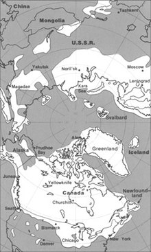
The maximum extent of glacial ice in the north polar area during the Pleistocene period

The modern continents were essentially at their present positions during the Pleistocene, the plates upon which they sit probably having moved no more than 100 km relative to each other since the beginning of the period. In glacial periods, the sea level would drop by over 100 metres during peak glaciation, exposing large areas of present continental shelf as dry land.

According to Mark Lynas (through collected data), the Pleistocene's overall climate could be characterized as a continuous El Niño with trade winds in the south Pacific weakening or heading east, warm air rising near Peru, warm water spreading from the west Pacific and the Indian Ocean to the east Pacific, and other El Niño markers.

Glacial features

Pleistocene climate was marked by repeated glacial cycles in which continental glaciers pushed to the 40th parallel in some places. It is estimated that, at maximum glacial extent, 30% of the Earth's surface was covered by ice. In addition, a zone of permafrost stretched southward from the edge of the glacial sheet, a few hundred kilometres in North America, and several hundred in Eurasia. The mean annual temperature at the edge of the ice was −6 °C (21 °F); at the edge of the permafrost, 0 °C (32 °F).

Each glacial advance tied up huge volumes of water in continental ice sheets 1,500 to 3,000 metres (4,900–9,800 ft) thick, resulting in temporary sea-level drops of 100 metres (300 ft) or more over the entire surface of the Earth. During interglacial times, such as at present, drowned coastlines were common, mitigated by isostatic or other emergent motion of some regions.

The effects of glaciation were global. Antarctica was ice-bound throughout the Pleistocene as well as the preceding Pliocene. The Andes were covered in the south by the Patagonian ice cap. There were glaciers in New Zealand and Tasmania. The current decaying glaciers of Mount Kenya, Mount Kilimanjaro, and the Ruwenzori Range in east and central Africa were larger. Glaciers existed in the mountains of Ethiopia and to the west in the Atlas mountains.

In the northern hemisphere, many glaciers fused into one. The Cordilleran Ice Sheet covered the North American northwest; the east was covered by the Laurentide. The Fenno-Scandian ice sheet rested on northern Europe, including much of Great Britain; the Alpine ice sheet on the Alps. Scattered domes stretched across Siberia and the Arctic shelf. The northern seas were ice-covered.

South of the ice sheets large lakes accumulated because outlets were blocked and the cooler air slowed evaporation. When the Laurentide Ice Sheet retreated, north-central North America was totally covered by Lake Agassiz. Over a hundred basins, now dry or nearly so, were overflowing in the North American west. Lake Bonneville, for example, stood where Great Salt Lake now does. In Eurasia, large lakes developed as a result of the runoff from the glaciers. Rivers were larger, had a more copious flow, and were braided. African lakes were fuller, apparently from decreased evaporation. Deserts, on the other hand, were drier and more extensive. Rainfall was lower because of the decreases in oceanic and other evaporation.

It has been estimated that during the Pleistocene, the East Antarctic Ice Sheet thinned by at least 500 meters, and that thinning since the Last Glacial Maximum is less than 50 meters and probably started after ca 14 ka.

Major events

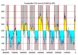
Ice ages as reflected in atmospheric CO2, stored in bubbles from glacial ice of Antarctica

Over 11 major glacial events have been identified, as well as many minor glacial events. A major glacial event is a general glacial excursion, termed a "glacial." Glacials are separated by "interglacials". During a glacial, the glacier experiences minor advances and retreats. The minor excursion is a "stadial"; times between stadials are "interstadials".

These events are defined differently in different regions of the glacial range, which have their own glacial history depending on latitude, terrain and climate. There is a general correspondence between glacials in different regions. Investigators often interchange the names if the glacial geology of a region is in the process of being defined. However, it is generally incorrect to apply the name of a glacial in one region to another.

For most of the 20th century only a few regions had been studied and the names were relatively few. Today the geologists of different nations are taking more of an interest in Pleistocene glaciology. As a consequence, the number of names is expanding rapidly and will continue to expand. Many of the advances and stadials remain unnamed. Also, the terrestrial evidence for some of them has been erased or obscured by larger ones, but evidence remains from the study of cyclical climate changes.

The glacials in the following tables show historical usages, are a simplification of a much more complex cycle of variation in climate and terrain, and are generally no longer used. These names have been abandoned in favor of numeric data because many of the correlations were found to be either inexact or incorrect and more than four major glacials have been recognized since the historical terminology was established.

Historical names of the "four major" glacials in four regions.
Region Glacial 1 Glacial 2 Glacial 3 Glacial 4
Alps Günz Mindel Riss Würm
North Europe Eburonian Elsterian Saalian Weichselian
British Isles Beestonian Anglian Wolstonian Devensian
Midwest U.S. Nebraskan Kansan Illinoian Wisconsinan
 
Historical names of interglacials.
Region Interglacial 1 Interglacial 2 Interglacial 3
Alps Günz-Mindel Mindel-Riss Riss-Würm
North Europe Waalian Holsteinian Eemian
British Isles Cromerian Hoxnian Ipswichian
Midwest U.S. Aftonian Yarmouthian Sangamonian

Corresponding to the terms glacial and interglacial, the terms pluvial and interpluvial are in use (Latin: pluvia, rain). A pluvial is a warmer period of increased rainfall; an interpluvial, of decreased rainfall. Formerly a pluvial was thought to correspond to a glacial in regions not iced, and in some cases it does. Rainfall is cyclical also. Pluvials and interpluvials are widespread.

There is no systematic correspondence of pluvials to glacials, however. Moreover, regional pluvials do not correspond to each other globally. For example, some have used the term "Riss pluvial" in Egyptian contexts. Any coincidence is an accident of regional factors. Only a few of the names for pluvials in restricted regions have been stratigraphically defined.

Palaeocycles

The sum of transient factors acting at the Earth's surface is cyclical: climate, ocean currents and other movements, wind currents, temperature, etc. The waveform response comes from the underlying cyclical motions of the planet, which eventually drag all the transients into harmony with them. The repeated glaciations of the Pleistocene were caused by the same factors.

The Mid-Pleistocene Transition, approximately one million years ago, saw a change from low-amplitude glacial cycles with a dominant periodicity of 41,000 years to asymmetric high-amplitude cycles dominated by a periodicity of 100,000 years.

However, a 2020 study concluded that ice age terminations might have been influenced by obliquity since the Mid-Pleistocene Transition, which caused stronger summers in the Northern Hemisphere.

Milankovitch cycles

Glaciation in the Pleistocene was a series of glacials and interglacials, stadials and interstadials, mirroring periodic changes in climate. The main factor at work in climate cycling is now believed to be Milankovitch cycles. These are periodic variations in regional and planetary solar radiation reaching the Earth caused by several repeating changes in the Earth's motion.

Milankovitch cycles cannot be the sole factor responsible for the variations in climate since they explain neither the long term cooling trend over the Plio-Pleistocene, nor the millennial variations in the Greenland Ice Cores. Milankovitch pacing seems to best explain glaciation events with periodicity of 100,000, 40,000, and 20,000 years. Such a pattern seems to fit the information on climate change found in oxygen isotope cores.

Oxygen isotope ratio cycles

In oxygen isotope ratio analysis, variations in the ratio of 18
O
to 16
O
(two isotopes of oxygen) by mass (measured by a mass spectrometer) present in the calcite of oceanic core samples is used as a diagnostic of ancient ocean temperature change and therefore of climate change. Cold oceans are richer in 18
O
, which is included in the tests of the microorganisms (foraminifera) contributing the calcite.

A more recent version of the sampling process makes use of modern glacial ice cores. Although less rich in 18
O
than sea water, the snow that fell on the glacier year by year nevertheless contained 18
O
and 16
O
in a ratio that depended on the mean annual temperature.

Temperature and climate change are cyclical when plotted on a graph of temperature versus time. Temperature coordinates are given in the form of a deviation from today's annual mean temperature, taken as zero. This sort of graph is based on another of isotope ratio versus time. Ratios are converted to a percentage difference from the ratio found in standard mean ocean water (SMOW).

The graph in either form appears as a waveform with overtones. One half of a period is a Marine isotopic stage (MIS). It indicates a glacial (below zero) or an interglacial (above zero). Overtones are stadials or interstadials.

According to this evidence, Earth experienced 102 MIS stages beginning at about 2.588 Ma BP in the Early Pleistocene Gelasian. Early Pleistocene stages were shallow and frequent. The latest were the most intense and most widely spaced.

By convention, stages are numbered from the Holocene, which is MIS1. Glacials receive an even number; interglacials, odd. The first major glacial was MIS2-4 at about 85–11 ka BP. The largest glacials were 2, 6, 12, and 16; the warmest interglacials, 1, 5, 9 and 11. For matching of MIS numbers to named stages, see under the articles for those names.

Fauna

Pleistocene of Northern Spain, including woolly mammoth, cave lions eating a reindeer, tarpans, and woolly rhinoceros
 
Pleistocene of South America, including Megatherium and two Glyptodon

Both marine and continental faunas were essentially modern but with many more large land mammals such as Mammoths, Mastodons, Diprotodon, Smilodon, tiger, lion, Aurochs, short-faced bears, giant sloths, Gigantopithecus and others. Isolated landmasses such as Australia, Madagascar, New Zealand and islands in the Pacific saw the evolution of large birds and even reptiles such as the Elephant bird, moa, Haast's eagle, Quinkana, Megalania and Meiolania.

The severe climatic changes during the Ice Age had major impacts on the fauna and flora. With each advance of the ice, large areas of the continents became totally depopulated, and plants and animals retreating southwards in front of the advancing glacier faced tremendous stress. The most severe stress resulted from drastic climatic changes, reduced living space, and curtailed food supply. A major extinction event of large mammals (megafauna), which included mammoths, mastodons, saber-toothed cats, glyptodons, the woolly rhinoceros, various giraffids, such as the Sivatherium; ground sloths, Irish elk, cave bears, Gomphothere, dire wolves, and short-faced bears, began late in the Pleistocene and continued into the Holocene. Neanderthals also became extinct during this period. At the end of the last ice age, cold-blooded animals, smaller mammals like wood mice, migratory birds, and swifter animals like whitetail deer had replaced the megafauna and migrated north. Late Pleistocene bighorn sheep were more slender and had longer legs than their descendants today. Scientists believe that the change in predator fauna after the late Pleistocene extinctions resulted in a change of body shape as the species adapted for increased power rather than speed.

The extinctions hardly affected Africa but were especially severe in North America where native horses and camels were wiped out.

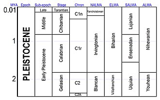
Various schemes for subdividing the Pleistocene

In July 2018, a team of Russian scientists in collaboration with Princeton University announced that they had brought two female nematodes frozen in permafrost, from around 42,000 years ago, back to life. The two nematodes, at the time, were the oldest confirmed living animals on the planet.

Humans

The evolution of anatomically modern humans took place during the Pleistocene. In the beginning of the Pleistocene Paranthropus species were still present, as well as early human ancestors, but during the lower Palaeolithic they disappeared, and the only hominin species found in fossilic records is Homo erectus for much of the Pleistocene. Acheulean lithics appear along with Homo erectus, some 1.8 million years ago, replacing the more primitive Oldowan industry used by A. garhi and by the earliest species of Homo. The Middle Paleolithic saw more varied speciation within Homo, including the appearance of Homo sapiens about 200,000 years ago.

According to mitochondrial timing techniques, modern humans migrated from Africa after the Riss glaciation in the Middle Palaeolithic during the Eemian Stage, spreading all over the ice-free world during the late Pleistocene. A 2005 study posits that humans in this migration interbred with archaic human forms already outside of Africa by the late Pleistocene, incorporating archaic human genetic material into the modern human gene pool.

Hominin species during Pleistocene
Homo (genus)AustralopithecusAustralopithecus sedibaAustralopithecus africanusHomo floresiensisHomo neanderthalensisHomo sapiensHomo heidelbergensisHomo erectusHomo nalediHomo habilisHolocenePleistocenePliocene

Classical radicalism

From Wikipedia, the free encyclopedia https://en.wikipedia.org/wiki/Cla...