Search This Blog

Sunday, October 10, 2021

Hot Jupiter

From Wikipedia, the free encyclopedia
 
Artist's impression of HD 188753 b, a hot Jupiter

Hot Jupiters are a class of gas giant exoplanets that are inferred to be physically similar to Jupiter but that have very short orbital periods (P < 10 days). The close proximity to their stars and high surface-atmosphere temperatures resulted in the moniker "hot Jupiters".

Hot Jupiters are the easiest extrasolar planets to detect via the radial-velocity method, because the oscillations they induce in their parent stars' motion are relatively large and rapid compared to those of other known types of planets. One of the best-known hot Jupiters is 51 Pegasi b. Discovered in 1995, it was the first extrasolar planet found orbiting a Sun-like star. 51 Pegasi b has an orbital period of about 4 days.

General characteristics

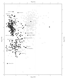
Hot Jupiters (along left edge, including most of planets detected using the transit method, indicated with black dots) discovered up to 2 January 2014
 
Hot Jupiter with hidden water

Though there is diversity among hot Jupiters, they do share some common properties.

  • Their defining characteristics are their large masses and short orbital periods, spanning 0.36–11.8 Jupiter masses and 1.3–111 Earth days. The mass cannot be greater than approximately 13.6 Jupiter masses because then the pressure and temperature inside the planet would be high enough to cause deuterium fusion, and the planet would be a brown dwarf.
  • Most have nearly circular orbits (low eccentricities). It is thought that their orbits are circularized by perturbations from nearby stars or tidal forces. Whether they remain in these circular orbits for long periods of time or collide with their host stars depends on the coupling of their orbital and physical evolution, which are related through the dissipation of energy and tidal deformation.
  • Many have unusually low densities. The lowest one measured thus far is that of TrES-4 at 0.222 g/cm3. The large radii of hot Jupiters are not yet fully understood but it is thought that the expanded envelopes can be attributed to high stellar irradiation, high atmospheric opacities, possible internal energy sources, and orbits close enough to their stars for the outer layers of the planets to exceed their Roche limit and be pulled further outward.
  • Usually they are tidally locked, with one side always facing its host star.
  • They are likely to have extreme and exotic atmospheres due to their short periods, relatively long days, and tidal locking.
  • Atmospheric dynamics models predict strong vertical stratification with intense winds and super-rotating equatorial jets driven by radiative forcing and the transfer of heat and momentum.Recent models also predict a variety of storms (vortices) that can mix their atmospheres and transport hot and cold regions of gas.
  • The day-night temperature difference at the photosphere is predicted to be substantial, approximately 500 K for a model based on HD 209458b.
  • They appear to be more common around F- and G-type stars and less so around K-type stars. Hot Jupiters around red dwarfs are very rare. Generalizations about the distribution of these planets must take into account the various observational biases, but in general their prevalence decreases exponentially as a function of the absolute stellar magnitude.

Formation and evolution

There are two general schools of thought regarding the origin of hot Jupiters: formation at a distance followed by inward migration and in-situ formation at the distances at which they're currently observed. The prevalent view is formation via orbital migration.

Migration

In the migration hypothesis, a hot Jupiter forms beyond the frost line, from rock, ice, and gases via the core accretion method of planetary formation. The planet then migrates inwards to the star where it eventually forms a stable orbit. The planet may have migrated inward smoothly via type II orbital migration. Or it may have migrated more suddenly due to gravitational scattering onto eccentric orbits during an encounter with another massive planet, followed by the circularization and shrinking of the orbits due to tidal interactions with the star. A hot Jupiter's orbit could also have been altered via the Kozai mechanism, causing an exchange of inclination for eccentricity resulting in a high eccentricity low perihelion orbit, in combination with tidal friction. This requires a massive body—another planet or a stellar companion—on a more distant and inclined orbit; approximately 50% of hot Jupiters have distant Jupiter-mass or larger companions, which can leave the hot Jupiter with an orbit inclined relative to the star's rotation.

The type II migration happens during the solar nebula phase, i.e. when gas is still present. Energetic stellar photons and strong stellar winds at this time remove most of the remaining nebula. Migration via the other mechanism can happen after the loss of the gas disk.

In situ

Instead of being gas giants that migrated inward, in an alternate hypothesis the cores of the hot Jupiters began as more common super-Earths which accreted their gas envelopes at their current locations, becoming gas giants in situ. The super-Earths providing the cores in this hypothesis could have formed either in situ or at greater distances and have undergone migration before acquiring their gas envelopes. Since super-Earths are often found with companions, the hot Jupiters formed in situ could also be expected to have companions. The increase of the mass of the locally growing hot Jupiter has a number of possible effects on neighboring planets. If the hot Jupiter maintains an eccentricity greater than 0.01, sweeping secular resonances can increase the eccentricity of a companion planet, causing it to collide with the hot Jupiter. The core of the hot Jupiter in this case would be unusually large. If the hot Jupiter's eccentricity remains small the sweeping secular resonances could also tilt the orbit of the companion. Traditionally, the in situ mode of conglomeration has been disfavored because the assembly of massive cores, which is necessary for the formation of hot Jupiters, requires surface densities of solids ≈ 104 g/cm2, or larger. Recent surveys, however, have found that the inner regions of planetary systems are frequently occupied by super-Earth type planets. If these super-Earths formed at greater distances and migrated closer, the formation of in situ hot Jupiters is not entirely in situ.

Atmospheric loss

If the atmosphere of a hot Jupiter is stripped away via hydrodynamic escape, its core may become a chthonian planet. The amount of gas removed from the outermost layers depends on the planet's size, the gases forming the envelope, the orbital distance from the star, and the star's luminosity. In a typical system, a gas giant orbiting at 0.02 AU around its parent star loses 5–7% of its mass during its lifetime, but orbiting closer than 0.015 AU can mean evaporation of a substantially larger fraction of the planet's mass. No such objects have been found yet and they are still hypothetical.

Comparison of "hot Jupiter" exoplanets (artist concept).
From top left to lower right: WASP-12b, WASP-6b, WASP-31b, WASP-39b, HD 189733b, HAT-P-12b, WASP-17b, WASP-19b, HAT-P-1b and HD 209458b.

Terrestrial planets in systems with hot Jupiters

Simulations have shown that the migration of a Jupiter-sized planet through the inner protoplanetary disk (the region between 5 and 0.1 AU from the star) is not as destructive as expected. More than 60% of the solid disk materials in that region are scattered outward, including planetesimals and protoplanets, allowing the planet-forming disk to reform in the gas giant's wake. In the simulation, planets up to two Earth masses were able to form in the habitable zone after the hot Jupiter passed through and its orbit stabilized at 0.1 AU. Due to the mixing of inner-planetary-system material with outer-planetary-system material from beyond the frost line, simulations indicated that the terrestrial planets that formed after a hot Jupiter's passage would be particularly water-rich. According to a 2011 study, hot Jupiters may become disrupted planets while migrating inwards; this could explain an abundance of "hot" Earth-sized to Neptune-sized planets within 0.2 AU of their host star.

One example of these sorts of systems is that of WASP-47. There are three inner planets and an outer gas giant in the habitable zone. The innermost planet, WASP-47e, is a large terrestrial planet of 6.83 Earth masses and 1.8 Earth radii; the hot Jupiter, b, is little heavier than Jupiter, but about 12.63 Earth radii; a final hot Neptune, c, is 15.2 Earth masses and 3.6 Earth radii. A similar orbital architecture is also exhibited by the Kepler-30 system.

Retrograde orbit

It has been found that several hot Jupiters have retrograde orbits, in stark contrast to what would be expected from most theories on planetary formation, though it is possible that the star itself flipped over early in their system's formation due to interactions between the star's magnetic field and the planet-forming disc, rather than the planet's orbit being disturbed. By combining new observations with the old data it was found that more than half of all the hot Jupiters studied have orbits that are misaligned with the rotation axis of their parent stars, and six exoplanets in this study have retrograde motion.

Recent research has found that several hot Jupiters are in misaligned systems. This misalignment may be related to the heat of the photosphere the hot Jupiter is orbiting. There are many proposed theories as to why this might occur. One such theory involves tidal dissipation and suggests there is a single mechanism for producing hot Jupiters and this mechanism yields a range of obliquities. Cooler stars with higher tidal dissipation damps the obliquity (explaining why hot Jupiters orbiting cooler stars are well aligned) while hotter stars do not damp the obliquity (explaining the observed misalignment).

Ultra-hot Jupiters

Ultra-hot Jupiters are hot Jupiters with a dayside temperature greater than 2,200 K. In such dayside atmospheres, most molecules dissociate into their constituent atoms and circulate to the nightside where they recombine into molecules again.

One example is TOI-1431b, announced by the University of Southern Queensland in April 2021, which has an orbital period of just two and a half days. Its dayside temperature is 2,700 K (2,427 °C), making it hotter than 40% of stars in our galaxy. The nightside temperature is 2,600 K (2,300 °C).

Ultra-short period planets

Ultra-short period planets (USP) are a class of planets with orbital periods below one day and occur only around stars of less than about 1.25 solar masses.

Confirmed transiting hot Jupiters that have orbital periods of less than one day include WASP-18b, WASP-19b, WASP-43b, and WASP-103b.

Puffy planets

Gas giants with a large radius and very low density are sometimes called "puffy planets" or "hot Saturns", due to their density being similar to Saturn's. Puffy planets orbit close to their stars so that the intense heat from the star combined with internal heating within the planet will help inflate the atmosphere. Six large-radius low-density planets have been detected by the transit method. In order of discovery they are: HAT-P-1b, COROT-1b, TrES-4, WASP-12b, WASP-17b, and Kepler-7b. Some hot Jupiters detected by the radial-velocity method may be puffy planets. Most of these planets are around or below Jupiter mass as more massive planets have stronger gravity keeping them at roughly Jupiter's size. Indeed, hot Jupiters with masses below Jupiter, and temperatures above 1800 Kelvin, are so inflated and puffed out that they are all on unstable evolutionary paths which eventually lead to Roche-Lobe overflow and the evaporation and loss of the planet's atmosphere.

Even when taking surface heating from the star into account, many transiting hot Jupiters have a larger radius than expected. This could be caused by the interaction between atmospheric winds and the planet's magnetosphere creating an electric current through the planet that heats it up, causing it to expand. The hotter the planet, the greater the atmospheric ionization, and thus the greater the magnitude of the interaction and the larger the electric current, leading to more heating and expansion of the planet. This theory matches the observation that planetary temperature is correlated with inflated planetary radii.

Moons

Theoretical research suggests that hot Jupiters are unlikely to have moons, due to both a small Hill sphere and the tidal forces of the stars they orbit, which would destabilize any satellite's orbit, the latter process being stronger for larger moons. This means that for most hot Jupiters, stable satellites would be small asteroid-sized bodies. Furthermore, the physical evolution of hot Jupiters can determine the final fate of their moons: stall them in semi-asymptotic semimajor axes, or eject them from the system where they may undergo other unknown processes. In spite of this, observations of WASP-12b suggest that it is orbited by at least 1 large exomoon.

Hot Jupiters around red giants

It has been proposed that gas giants orbiting red giants at distances similar to that of Jupiter could be hot Jupiters due to the intense irradiation they would receive from their stars. It is very likely that in the Solar System Jupiter will become a hot Jupiter after the transformation of the Sun into a red giant. The recent discovery of particularly low density gas giants orbiting red giant stars supports this theory.

Hot Jupiters orbiting red giants would differ from those orbiting main-sequence stars in a number of ways, most notably the possibility of accreting material from the stellar winds of their stars and, assuming a fast rotation (not tidally locked to their stars), a much more evenly distributed heat with many narrow-banded jets. Their detection using the transit method would be much more difficult due to their tiny size compared to the stars they orbit, as well as the long time needed (months or even years) for one to transit their star as well as to be occulted by it.

Star-planet interactions

Theoretical research since 2000 suggested that "hot Jupiters" may cause increased flaring due to the interaction of the magnetic fields of the star and its orbiting exoplanet, or because of tidal forces between them. These effects are called "star-planet interactions" or SPIs. The HD 189733 system is the best-studied exoplanet system where this effect was thought to occur.

In 2008, a team of astronomers first described how as the exoplanet orbiting HD 189733 A reaches a certain place in its orbit, it causes increased stellar flaring. In 2010, a different team found that every time they observe the exoplanet at a certain position in its orbit, they also detected X-ray flares. In 2019, astronomers analyzed data from Arecibo Observatory, MOST, and the Automated Photoelectric Telescope, in addition to historical observations of the star at radio, optical, ultraviolet, and X-ray wavelengths to examine these claims. They found that the previous claims were exaggerated and the host star failed to display many of the brightness and spectral characteristics associated with stellar flaring and solar active regions, including sunspots. Their statistical analysis also found that many stellar flares are seen regardless of the position of the exoplanet, therefore debunking the earlier claims. The magnetic fields of the host star and exoplanet do not interact, and this system is no longer believed to have a "star-planet interaction." Some researchers had also suggested that HD 189733 accretes, or pulls, material from its orbiting exoplanet at a rate similar to those found around young protostars in T Tauri star systems. Later analysis demonstrated that very little, if any, gas was accreted from the "hot Jupiter" companion.

Hadrian's Wall

From Wikipedia, the free encyclopedia

Hadrian (/ˈhdriən/; Latin: Caesar Traianus Hadrianus [ˈkae̯s̠ar t̪rajˈjaːnʊs̠ (h)a.d̪riˈjaːnʊs̠]; 24 January 76 – 10 July 138) was Roman emperor from 117 to 138. He was born into a Roman Italo-Hispanic family that settled in Spain from the Italian city of Atri in Picenum. His father was of senatorial rank and was a first cousin of Emperor Trajan. Hadrian married Trajan's grand-niece Vibia Sabina early in his career, before Trajan became emperor and possibly at the behest of Trajan's wife Pompeia Plotina. Plotina and Trajan's close friend and adviser Lucius Licinius Sura were well disposed towards Hadrian. When Trajan died, his widow claimed that he had nominated Hadrian as emperor immediately before his death.

Rome's military and Senate approved Hadrian's succession, but four leading senators were unlawfully put to death soon after. They had opposed Hadrian or seemed to threaten his succession, and the Senate held him responsible for it and never forgave him. He earned further disapproval among the elite by abandoning Trajan's expansionist policies and territorial gains in Mesopotamia, Assyria, Armenia, and parts of Dacia. Hadrian preferred to invest in the development of stable, defensible borders and the unification of the empire's disparate peoples. He is known for building Hadrian's Wall, which marked the northern limit of Britannia.

Hadrian energetically pursued his own Imperial ideals and personal interests. He visited almost every province of the Empire, accompanied by an Imperial retinue of specialists and administrators. He encouraged military preparedness and discipline, and he fostered, designed, or personally subsidised various civil and religious institutions and building projects. In Rome itself, he rebuilt the Pantheon and constructed the vast Temple of Venus and Roma. In Egypt, he may have rebuilt the Serapeum of Alexandria. He was an ardent admirer of Greece and sought to make Athens the cultural capital of the Empire, so he ordered the construction of many opulent temples there. His intense relationship with Greek youth Antinous and the latter's untimely death led Hadrian to establish a widespread cult late in his reign. He suppressed the Bar Kokhba revolt in Judaea, but his reign was otherwise peaceful.

Hadrian's last years were marred by chronic illness. He saw the Bar Kokhba revolt as the failure of his panhellenic ideal. He executed two more senators for their alleged plots against him, and this provoked further resentment. His marriage to Vibia Sabina had been unhappy and childless; he adopted Antoninus Pius in 138 and nominated him as a successor, on the condition that Antoninus adopt Marcus Aurelius and Lucius Verus as his own heirs. Hadrian died the same year at Baiae, and Antoninus had him deified, despite opposition from the Senate. Edward Gibbon includes him among the Empire's "Five Good Emperors", a "benevolent dictator"; Hadrian's own Senate found him remote and authoritarian. He has been described as enigmatic and contradictory, with a capacity for both great personal generosity and extreme cruelty and driven by insatiable curiosity, self-conceit, and ambition.


Roman military frontiers and fortifications

Map of all the territories once occupied by the Roman Empire, along with locations of limes 
 
Roman military borders and fortifications were part of a grand strategy of territorial defense in the Roman Empire, although this is a matter of debate. By the early 2nd century, the Roman Empire had reached the peak of its territorial expansion and rather than constantly expanding their borders as earlier in the Empire and Republic, the Romans solidified their position by fortifying their strategic position with a series of fortifications and established lines of defense. Historian Adrian Goldsworthy argues that the Romans had reached the natural limits which their military traditions afforded them conquest over and that beyond the borders of the early-to-mid Empire lay peoples whose military traditions made them militarily unconquerable, despite many Roman battle victories. In particular, Goldsworthy argues that the cavalry-based warfare of the Parthians, Sarmatians and Persians presented a major challenge to the expansion of Rome's infantry-based armies.

Nature of the fortifications

The borders of the Roman Empire, which fluctuated throughout the empire's history, were a combination of natural frontiers (the Rhine and Danube rivers to the north and east, the Atlantic to the west, and deserts to the south) and man-made fortifications which separated the lands of the empire from the "barbarian" lands beyond.

Individual fortifications had been constructed by the Roman military from as early as the building of Rome's first city walls in the 6th or 7th century BC. However, systematic construction of fortifications around the periphery of the empire on a strategic scale began around 40 AD under Emperor Caligula. However, it was under Hadrian's rule, which began in 117, that the Roman frontier was systematically fortified. He spent half of his 21-year reign touring the empire and advocating for the construction of forts, towers, and walls all across the edges of the empire. The coherent construction of these fortifications on a strategic scale (i.e. to protect the empire as a whole rather than fortifying individual settlements) are known as the limes, and continued until around 270.

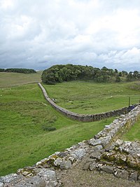
The limes consisted of fortresses for legions or vexillations (e.g. Segedunum) as well as a system of roads for the rapid transit of troops and, in some places, extensive walls. Perhaps the most famous example of these is Hadrian's Wall in Great Britain, which was built across the entire width of the island to protect from attack from tribes located in modern-day Scotland. The so-called Limes Britannicus is perhaps the best example of the ultimate limes - like the Great Wall of China, it was an attempt to construct a continuous man-made fortification along the length of an entire border, a massive undertaking. However, it is not correct to interpret other limes in the same way or to view the limes as an impenetrable barrier. Other limes would not have had a continuous man-made fortification for the entirety of their length. In places, a river, desert or natural outcropping of rock could provide the same effect for zero outlay. Also, fortifications as impressive as Hadrian's Wall were not unbreachable: with milecastles some distance apart and patrols infrequent, small enemy forces would have been able to penetrate the defenses easily for small-scale raiding. However, a raiding party would be forced to fight its way through one of the well-defended gates, abandon its loot, such as cattle, thus negating the whole purpose of the raid or be trapped against the wall by the responding legions. Additionally, a large army would have been able to force a crossing of the limes using siege equipment. The value of the limes lay not in its absolute impenetrability but, as S. Thomas Parker argues, in its hindrance to the enemy: granting a delay or warning that could be used to summon concentrated Roman forces to the site. The limes are therefore perhaps better seen as an instrument allowing a greater economy of force in defense of a border than otherwise would be necessary to provide the same level of defense.

After 270, the maintenance of an impenetrable solid frontier was abandoned by Constantine I in favor of a policy, whether deliberate or forced by circumstance, of "defense in depth". This called for the maintenance of a softer, deeper perimeter area of defense, with concentrated hard points throughout its depth. The idea was that any invading force of a sufficient size could penetrate the initial perimeter but in doing so with any element of surprise or rapid movement would be forced to leave several defended hard points (fortresses) to its rear, hampering its lines of supply and communications, and threatening surrounding of the force.

In the very late Empire the frontiers became even more elastic, with little effort expended in maintaining frontier defense. Instead, armies were concentrated near the heart of the empire, and enemies allowed to penetrate in cases as far inwards as the Italian peninsula before being met in battle.

Northern borders

Britannia

After conquering much of the modern landmass of Great Britain, the Romans halted their northern expansion at the southern fringe of Caledonia, what is now central Scotland. This left them with a border shared with a people who made repeated raids and insurrections against them. Unlike other borders throughout the empire, there was no natural border to fall back on such as desert or wide river that crossed the whole peninsula, so instead a series of defenses were built in southern to mid-Scotland in order to protect the province of Britannia from the Caledonians and later the Picts.

Although the border was not a continuous wall, a series of fortifications known as Gask Ridge in mid-Scotland may well be Rome's earliest fortified land frontier. Constructed in the 70CE or 80CE, it was superseded by the later Hadrian's Wall forty years later and then the final Antonine Wall twenty years after that. Rather than representing a series of consecutive advancements, the border should be seen as fluctuating - the Antonine Wall for example was built between 142 and 144, abandoned by 164 and briefly re-occupied in 208.

Although records are scarce, there are indications that the border fluctuated between the various fortifications depending on the local strength of the military. There is archaeological evidence for widespread burning of fortifications, but it is disputed whether this represents fortifications falling to attack or part of the normal process of the Roman military to destroy their own fortified camps on abandonment so as not to furnish the enemy with a fortified base at their expense.

These northern fortifications are sometimes styled the Limes Britannicus. The average garrison of the wall fortifications is thought to have been around 10,000 men. Along with a continuous wall (except in the case of Gask Ridge), there existed a metaled road immediately behind the wall for transport of troops. Along the wall there existed a few large forts for legions or vexillations, as well as a series of milecastles - effectively watchtowers that were unable to defend a stretch of wall against anything but low-scale raiding but were able to signal attack to legionary forts by means of fire signals atop the towers.

In the later Empire, Roman Britannia found itself increasingly vulnerable to external aggression, in parallel to attacks felt across the length of the Empire's borders. However, since Britannia shared no land bridge with continental Europe, the method of attack and thus methods of defense varied from the imperial standard. A series of naval forts was built along the south east coast, initially to combat piracy but later to protect from raiding and the threat of invasion from Saxons that eventually led to the Saxon occupation of Lowland Britain by 600 and is reflected in the name of the fortification system: the Saxon Shore, which extended to the northern coasts of France. Each shore fort both protected against direct attack and also sheltered a small naval sub-fleet of vessels that could patrol the coast against pirates and raiders.

Continental Europe

Roman watchtower and beacon on the lower Danube frontier

In continental Europe, the borders were generally well defined, usually following the courses of major rivers such as the Rhine and the Danube. Nevertheless, those were not always the final border lines: the original province of Dacia, in modern Romania, was completely north of the Danube, and the province of Germania Magna, which should not be confused with Germania Inferior and Germania Superior, was the land between the Rhine, the Danube and the Elbe (Although this province was lost three years after its creation as a result of the Battle of Teutoburg Forest). The limes that ran across the line of the Rhine-Danube was known as the Limes Germanicus. It consisted of:

  • The Lower (Northern) Germanic Limes, which extended from the North Sea at Katwijk in the Netherlands along the Rhine;
  • The Upper Germanic Limes (just to be confusing, also called the Rhaetian Limes or simply "the Limes") started from the Rhine at Rheinbrohl (Neuwied (district)) across the Taunus mountains to the river Main (East of Hanau), then along the Main to Miltenberg, and from Osterburken (Neckar-Odenwald-Kreis) south to Lorch (Ostalbkreis) in a nearly perfect straight line of more than 70 km;
  • The proper Rhaetian Limes extended east from Lorch to Eining (close to Kelheim) on the Danube. The total length was 568 km (353 mi). It included at least 60 castles and 900 watchtowers.

In Dacia, the limes between the Black Sea and the Danube were a mix of the camps and the wall defenses: the Limes Moesiae was the conjunction of two, and sometimes three, lines of vallum, with a Great Camp and many minor camps spread through the fortifications.

Eastern borders

The eastern borders changed many times, of which the most enduring was the Euphrates river, bordering the Parthian Empire in modern Iran and western Iraq. Rome advanced beyond the Euphrates for a time upon defeating their rivals, the Parthians in 116 AD, when Trajan captured Ctesiphon, and established new provinces in Assyria and Babylonia. Later that year he took the Parthian capital, Susa, and deposed the Parthian King Osroes I. However, the Romans did not Romanize the entire Parthian Empire, leaving Parthamaspates as a puppet king on the throne to rule over former Parthian lands with the exclusion of modern Iraq, which became Assyria and Mesopotamia.

Southern borders

At the empire's greatest extent, the southern borders were the deserts of Arabia and the Sahara, that represented a natural barrier to prevent expansion. The Empire controlled the Mediterranean shores and the mountains opposite. However the Romans attempted twice to occupy effectively the Siwa Oasis (and failed) and controlled the Nile many miles into Africa until the 1st Cataract near the modern border between Egypt and Sudan.

For Mauretania there was a single wall with forts on both sides of it, the Limes Mauretaniae. In other places, such as Syria and Arabia Petraea, there was instead a network of border settlements and forts occupied by the Roman army.

Western borders

The western borders were mainly protected by the Atlantic coast and unfortified.

Great Wall of China


Great Wall of China
萬里長城 / 万里长城
The Great Wall of China at Jinshanling-edit.jpg
 
Map of the Great Wall of China.jpg
Map of all the wall constructions
 
General information
TypeFortification
CountryChina
Coordinates40.68°N 117.23°ECoordinates: 40.68°N 117.23°E
Technical details
Size21,196 km (13,171 mi)

Official nameThe Great Wall
TypeCultural
Criteriai, ii, iii, iv, vi
Designated1987 (11th session)
Reference no.438
State PartyChina
RegionAsia-Pacific
Great Wall of China
Traditional Chinese長城
Simplified Chinese长城
Literal meaning"The Long Wall"
Alternative Chinese name
Traditional Chinese萬里長城
Simplified Chinese万里长城
Literal meaning"The 10,000-li Long Wall"

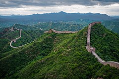
The Great Wall of China (traditional Chinese: 萬里長城; simplified Chinese: 万里长城; pinyin: Wànlǐ Chángchéng) is a series of fortifications that were built across the historical northern borders of ancient Chinese states and Imperial China as protection against various nomadic groups from the Eurasian Steppe. Several walls were built from as early as the 7th century BC, with selective stretches later joined together by Qin Shi Huang (220–206 BC), the first emperor of China. Little of the Qin wall remains. Later on, many successive dynasties built and maintained multiple stretches of border walls. The most well-known sections of the wall were built by the Ming dynasty (1368–1644).

Apart from defense, other purposes of the Great Wall have included border controls, allowing the imposition of duties on goods transported along the Silk Road, regulation or encouragement of trade and the control of immigration and emigration. Furthermore, the defensive characteristics of the Great Wall were enhanced by the construction of watchtowers, troop barracks, garrison stations, signaling capabilities through the means of smoke or fire, and the fact that the path of the Great Wall also served as a transportation corridor.

The frontier walls built by different dynasties have multiple courses. Collectively, they stretch from Liaodong in the east to Lop Lake in the west, from the present-day Sino–Russian border in the north to Tao River (Taohe) in the south; along an arc that roughly delineates the edge of the Mongolian steppe; spanning over 20,000 km (12,000 mi) in total. Today, the defensive system of the Great Wall is generally recognized as one of the most impressive architectural feats in history.

Names

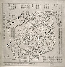
Huayi tu, a 1136 map of China with the Great Wall depicted on the northern edge of the country

The collection of fortifications known as the Great Wall of China has historically had a number of different names in both Chinese and English.

In Chinese histories, the term "Long Wall(s)" (t 長城, s 长城, Chángchéng) appears in Sima Qian's Records of the Grand Historian, where it referred both to the separate great walls built between and north of the Warring States and to the more unified construction of the First Emperor. The Chinese character , meaning city or fortress, is a phono-semantic compound of the "earth" radical and phonetic , whose Old Chinese pronunciation has been reconstructed as *deŋ. It originally referred to the rampart which surrounded traditional Chinese cities and was used by extension for these walls around their respective states; today, however, it is much more often the Chinese word for "city".

The longer Chinese name "Ten-Thousand Mile Long Wall" (t 萬里長城, s 万里长城, Wànlǐ Chángchéng) came from Sima Qian's description of it in the Records, though he did not name the walls as such. The AD 493 Book of Song quotes the frontier general Tan Daoji referring to "the long wall of 10,000 miles", closer to the modern name, but the name rarely features in pre-modern times otherwise. The traditional Chinese mile (, ) was an often irregular distance that was intended to show the length of a standard village and varied with terrain but was usually standardized at distances around a third of an English mile (540 m). Since China's metrication in 1930, it has been exactly equivalent to 500 metres or 1,600 feet, which would make the wall's name describe a distance of 5,000 km (3,100 mi). However, this use of "ten-thousand" (wàn) is figurative in a similar manner to the Greek and English myriad and simply means "innumerable" or "immeasurable".

Because of the wall's association with the First Emperor's supposed tyranny, the Chinese dynasties after Qin usually avoided referring to their own additions to the wall by the name "Long Wall". Instead, various terms were used in medieval records, including "frontier(s)" (, Sài),[15] "rampart(s)" (, Yuán), "barrier(s)" (, Zhàng), "the outer fortresses" (, Wàibǎo), and "the border wall(s)" (t , s , Biānqiáng). Poetic and informal names for the wall included "the Purple Frontier" (, Zǐsài) and "the Earth Dragon" (t , s , Tǔlóng). Only during the Qing period did "Long Wall" become the catch-all term to refer to the many border walls regardless of their location or dynastic origin, equivalent to the English "Great Wall".

Sections of the wall in south Gobi Desert and Mongolian steppe are sometimes referred to as "Wall of Genghis Khan", even though Genghis Khan did not construct any walls or permanent defense lines himself.

The current English name evolved from accounts of "the Chinese wall" from early modern European travelers. By the nineteenth century, "The Great Wall of China" had become standard in English and French, although other European languages such as German continue to refer to it as "the Chinese wall".

History

Early walls

The Great Wall of the Qin stretches from Lintao to Liaodong

The Chinese were already familiar with the techniques of wall-building by the time of the Spring and Autumn period between the 8th and 5th centuries BC. During this time and the subsequent Warring States period, the states of Qin, Wei, Zhao, Qi, Han, Yan, and Zhongshan all constructed extensive fortifications to defend their own borders. Built to withstand the attack of small arms such as swords and spears, these walls were made mostly of stone or by stamping earth and gravel between board frames.

The Great Wall of the Han is the longest of all walls, from Mamitu near Yumenguan to Liaodong

King Zheng of Qin conquered the last of his opponents and unified China as the First Emperor of the Qin dynasty ("Qin Shi Huang") in 221 BC. Intending to impose centralized rule and prevent the resurgence of feudal lords, he ordered the destruction of the sections of the walls that divided his empire among the former states. To position the empire against the Xiongnu people from the north, however, he ordered the building of new walls to connect the remaining fortifications along the empire's northern frontier. "Build and move on" was a central guiding principle in constructing the wall, implying that the Chinese were not erecting a permanently fixed border. Transporting the large quantity of materials required for construction was difficult, so builders always tried to use local resources. Stones from the mountains were used over mountain ranges, while rammed earth was used for construction in the plains. There are no surviving historical records indicating the exact length and course of the Qin walls. Most of the ancient walls have eroded away over the centuries, and very few sections remain today. The human cost of the construction is unknown, but it has been estimated by some authors that hundreds of thousands workers died building the Qin wall. Later, the Han, the Northern Dynasties and the Sui all repaired, rebuilt, or expanded sections of the Great Wall at great cost to defend themselves against northern invaders. The Tang and Song dynasties did not undertake any significant effort in the region. Non-Han dynasties also built their border walls: the Xianbei-ruled Northern Wei, the Khitan-ruled Liao, Jurchen Jin and the Tangut-established Western Xia, who ruled vast territories over Northern China throughout centuries, all constructed defensive walls but those were located much to the north of the other Great Walls as we know it, within China's province of Inner Mongolia and in Mongolia itself.

Ming era

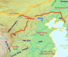
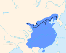
The extent of the Ming Empire and its walls

The Great Wall concept was revived again under the Ming in the 14th century, and following the Ming army's defeat by the Oirats in the Battle of Tumu. The Ming had failed to gain a clear upper hand over the Mongolian tribes after successive battles, and the long-drawn conflict was taking a toll on the empire. The Ming adopted a new strategy to keep the nomadic tribes out by constructing walls along the northern border of China. Acknowledging the Mongol control established in the Ordos Desert, the wall followed the desert's southern edge instead of incorporating the bend of the Yellow River.

Unlike the earlier fortifications, the Ming construction was stronger and more elaborate due to the use of bricks and stone instead of rammed earth. Up to 25,000 watchtowers are estimated to have been constructed on the wall. As Mongol raids continued periodically over the years, the Ming devoted considerable resources to repair and reinforce the walls. Sections near the Ming capital of Beijing were especially strong. Qi Jiguang between 1567 and 1570 also repaired and reinforced the wall, faced sections of the ram-earth wall with bricks and constructed 1,200 watchtowers from Shanhaiguan Pass to Changping to warn of approaching Mongol raiders. During the 1440s–1460s, the Ming also built a so-called "Liaodong Wall". Similar in function to the Great Wall (whose extension, in a sense, it was), but more basic in construction, the Liaodong Wall enclosed the agricultural heartland of the Liaodong province, protecting it against potential incursions by Jurched-Mongol Oriyanghan from the northwest and the Jianzhou Jurchens from the north. While stones and tiles were used in some parts of the Liaodong Wall, most of it was in fact simply an earth dike with moats on both sides.

Towards the end of the Ming, the Great Wall helped defend the empire against the Manchu invasions that began around 1600. Even after the loss of all of Liaodong, the Ming army held the heavily fortified Shanhai Pass, preventing the Manchus from conquering the Chinese heartland. The Manchus were finally able to cross the Great Wall in 1644, after Beijing had already fallen to Li Zicheng's rebels. Before this time, the Manchus had crossed the Great Wall multiple times to raid, but this time it was for conquest. The gates at Shanhai Pass were opened on May 25 by the commanding Ming general, Wu Sangui, who formed an alliance with the Manchus, hoping to use the Manchus to expel the rebels from Beijing. The Manchus quickly seized Beijing, and eventually defeated both the rebel-founded Shun dynasty and the remaining Ming resistance, establishing the Qing dynasty rule over all of China.

Under Qing rule, China's borders extended beyond the walls and Mongolia was annexed into the empire, so constructions on the Great Wall were discontinued. On the other hand, the so-called Willow Palisade, following a line similar to that of the Ming Liaodong Wall, was constructed by the Qing rulers in Manchuria. Its purpose, however, was not defense but rather to prevent Han Chinese migration into Manchuria.

Foreign accounts

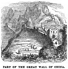
Part of the Great Wall of China (April 1853, X, p. 41)
 
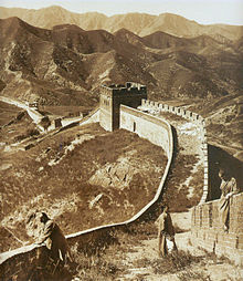
The Great Wall in 1907

None of the Europeans who visited China or Mongolia in the 13th and 14th centuries, such as Giovanni da Pian del Carpine, William of Rubruck, Marco Polo, Odoric of Pordenone and Giovanni de' Marignolli, mentioned the Great Wall.

The North African traveler Ibn Battuta, who also visited China during the Yuan dynasty c. 1346, had heard about China's Great Wall, possibly before he had arrived in China. He wrote that the wall is "sixty days' travel" from Zeitun (modern Quanzhou) in his travelogue Gift to Those Who Contemplate the Wonders of Cities and the Marvels of Travelling. He associated it with the legend of the wall mentioned in the Qur'an, which Dhul-Qarnayn (commonly associated with Alexander the Great) was said to have erected to protect people near the land of the rising sun from the savages of Gog and Magog. However, Ibn Battuta could find no one who had either seen it or knew of anyone who had seen it, suggesting that although there were remnants of the wall at that time, they were not significant.

Soon after Europeans reached Ming China by ship in the early 16th century, accounts of the Great Wall started to circulate in Europe, even though no European was to see it for another century. Possibly one of the earliest European descriptions of the wall and of its significance for the defense of the country against the "Tartars" (i.e. Mongols) may be the one contained in João de Barros's 1563 Asia. Other early accounts in Western sources include those of Gaspar da Cruz, Bento de Goes, Matteo Ricci, and Bishop Juan González de Mendoza, the latter in 1585 describing it as a "superbious and mightie work" of architecture, though he had not seen it. In 1559, in his work "A Treatise of China and the Adjoyning Regions", Gaspar da Cruz offers an early discussion of the Great Wall. Perhaps the first recorded instance of a European actually entering China via the Great Wall came in 1605, when the Portuguese Jesuit brother Bento de Góis reached the northwestern Jiayu Pass from India. Early European accounts were mostly modest and empirical, closely mirroring contemporary Chinese understanding of the Wall, although later they slid into hyperbole, including the erroneous but ubiquitous claim that the Ming walls were the same ones that were built by the first emperor in the 3rd century BC.

When China opened its borders to foreign merchants and visitors after its defeat in the First and Second Opium Wars, the Great Wall became a main attraction for tourists. The travelogues of the later 19th century further enhanced the reputation and the mythology of the Great Wall.

Course

A formal definition of what constitutes a "Great Wall" has not been agreed upon, making the full course of the Great Wall difficult to describe in its entirety. The defensive lines contain multiple stretches of ramparts, trenches and ditches, as well as individual fortresses.

In 2012, based on existing research and the results of a comprehensive mapping survey, the National Cultural Heritage Administration of China concluded that the remaining Great Wall associated sites include 10,051 wall sections, 1,764 ramparts or trenches, 29,510 individual buildings, and 2,211 fortifications or passes, with the walls and trenches spanning a total length of 21,196 km (13,171 mi). Incorporating advanced technologies, the study has concluded that the Ming Great Wall measure 8,850 km (5,500 mi). This consists of 6,259 km (3,889 mi) of wall sections, 359 km (223 mi) of trenches and 2,232 km (1,387 mi) of natural defensive barriers such as hills and rivers. In addition, Qin, Han and earlier Great Wall sites are 3,080 km (1,914 mi) long in total; Jin dynasty (1115–1234) border fortifications are 4,010 km (2,492 mi) in length; the remainder date back to Northern Wei, Northern Qi, Sui, Tang, the Five Dynasties, Song, Liao and Xixia. About half of the sites are located in Inner Mongolia (31%) and Hebei (19%).

Han Great Wall

Han fortifications starts from Yumen Pass and Yang Pass, southwest of Dunhuang, in Gansu province. Ruins of the remotest Han border posts are found in Mamitu (t 迷途, s 迷途, Mǎmítú, l "horses losing their way") near Yumen Pass.

Ming Great Wall

The Jiayu Pass, located in Gansu province, is the western terminus of the Ming Great Wall. From Jiayu Pass the wall travels discontinuously down the Hexi Corridor and into the deserts of Ningxia, where it enters the western edge of the Yellow River loop at Yinchuan. Here the first major walls erected during the Ming dynasty cut through the Ordos Desert to the eastern edge of the Yellow River loop. There at Piantou Pass (t , s , Piāntóuguān) in Xinzhou, Shanxi province, the Great Wall splits in two with the "Outer Great Wall" (t 長城, s 长城, Wài Chǎngchéng) extending along the Inner Mongolia border with Shanxi into Hebei province, and the "Inner Great Wall" (t 長城, s 长城, Nèi Chǎngchéng) running southeast from Piantou Pass for some 400 km (250 mi), passing through important passes like the Pingxing Pass and Yanmen Pass before joining the Outer Great Wall at Sihaiye (四海, Sìhǎiyě), in Beijing's Yanqing County.

The sections of the Great Wall around Beijing municipality are especially famous: they were frequently renovated and are regularly visited by tourists today. The Badaling Great Wall near Zhangjiakou is the most famous stretch of the wall, for this was the first section to be opened to the public in the People's Republic of China, as well as the showpiece stretch for foreign dignitaries. The Badaling Great Wall saw nearly 10 million visitors in 2018, and in 2019, a daily limit of 65,000 visitors was instated. South of Badaling is the Juyong Pass; when it was used by the Chinese to protect their land, this section of the wall had many guards to defend the capital Beijing. Made of stone and bricks from the hills, this portion of the Great Wall is 7.8 m (25 ft 7 in) high and 5 m (16 ft 5 in) wide.

One of the most striking sections of the Ming Great Wall is where it climbs extremely steep slopes in Jinshanling. There it runs 11 km (7 mi) long, ranges from 5 to 8 m (16 ft 5 in to 26 ft 3 in) in height, and 6 m (19 ft 8 in) across the bottom, narrowing up to 5 m (16 ft 5 in) across the top. Wangjing Lou (t , s , Wàngjīng Lóu) is one of Jinshanling's 67 watchtowers, 980 m (3,220 ft) above sea level. Southeast of Jinshanling is the Mutianyu Great Wall which winds along lofty, cragged mountains from the southeast to the northwest for 2.25 km (1.40 mi). It is connected with Juyongguan Pass to the west and Gubeikou to the east. This section was one of the first to be renovated following the turmoil of the Cultural Revolution.

At the edge of the Bohai Gulf is Shanhai Pass, considered the traditional end of the Great Wall and the "First Pass Under Heaven". The part of the wall inside Shanhai Pass that meets the sea is named the "Old Dragon Head". 3 km (2 mi) north of Shanhai Pass is Jiaoshan Great Wall (t 焦山長城, s 长城, Jiāoshān Chángchéng), the site of the first mountain of the Great Wall. 15 km (9 mi) northeast from Shanhaiguan is Jiumenkou (t , s , Jiǔménkǒu), which is the only portion of the wall that was built as a bridge.

In 2009, 180 km of previously unknown sections of the Ming wall concealed by hills, trenches and rivers were discovered with the help of infrared range finders and GPS devices. In March and April 2015, nine sections with a total length of more than 10 km (6 mi), believed to be part of the Great Wall, were discovered along the border of Ningxia autonomous region and Gansu province.

Characteristics

Before the use of bricks, the Great Wall was mainly built from rammed earth, stones, and wood. During the Ming, however, bricks were heavily used in many areas of the wall, as were materials such as tiles, lime, and stone. The size and weight of the bricks made them easier to work with than earth and stone, so construction quickened. Additionally, bricks could bear more weight and endure better than rammed earth. Stone can hold under its own weight better than brick, but is more difficult to use. Consequently, stones cut in rectangular shapes were used for the foundation, inner and outer brims, and gateways of the wall. Battlements line the uppermost portion of the vast majority of the wall, with defensive gaps a little over 30 cm (12 in) tall, and about 23 cm (9.1 in) wide. From the parapets, guards could survey the surrounding land. Communication between the army units along the length of the Great Wall, including the ability to call reinforcements and warn garrisons of enemy movements, was of high importance. Signal towers were built upon hill tops or other high points along the wall for their visibility. Wooden gates could be used as a trap against those going through. Barracks, stables, and armories were built near the wall's inner surface.

Condition

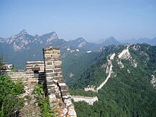
A more rural portion of the Great Wall that stretches through the mountains, here seen in slight disrepair

While portions north of Beijing and near tourist centers have been preserved and even extensively renovated, in many other locations the wall is in disrepair. The wall sometimes provided a source of stones to build houses and roads. Sections of the wall are also prone to graffiti and vandalism, while inscribed bricks were pilfered and sold on the market for up to 50 renminbi. Parts have been destroyed to make way for construction or mining. A 2012 report by the National Cultural Heritage Administration states that 22% of the Ming Great Wall has disappeared, while 1,961 km (1,219 mi) of wall have vanished. More than 60 km (37 mi) of the wall in Gansu province may disappear in the next 20 years, due to erosion from sandstorms. In some places, the height of the wall has been reduced from more than 5 m (16 ft 5 in) to less than 2 m (6 ft 7 in). Various square lookout towers that characterize the most famous images of the wall have disappeared. Many western sections of the wall are constructed from mud, rather than brick and stone, and thus are more susceptible to erosion. In 2014 a portion of the wall near the border of Liaoning and Hebei province was repaired with concrete. The work has been much criticized.

Visibility from space

From the Moon

The notion that the wall can be seen from the moon (with an average orbital radius of 385,000 km (239,000 miles)) is a well-known but untrue myth.

One of the earliest known references to the myth that the Great Wall can be seen from the moon appears in a letter written in 1754 by the English antiquary William Stukeley. Stukeley wrote that, "This mighty wall [Hadrian's wall] of four score miles [130 km] in length is only exceeded by the Chinese Wall, which makes a considerable figure upon the terrestrial globe, and may be discerned at the Moon." The claim was also mentioned by Henry Norman in 1895 where he states "besides its age it enjoys the reputation of being the only work of human hands on the globe visible from the Moon." The issue of "canals" on Mars was prominent in the late 19th century and may have led to the belief that long, thin objects were visible from space. The claim that the Great Wall is visible from the moon also appears in 1932's Ripley's Believe It or Not! strip.

The claim that the Great Wall is visible from the moon has been debunked many times (the apparent width of the Great Wall from the Moon would be the same as that of a human hair viewed from 3 km (2 mi) away) but is still ingrained in popular culture.

From low Earth orbit

Identical satellite images of a section of the Great Wall in northern Shanxi, running diagonally from lower left to upper right and not to be confused with the more prominent river running from upper left to lower right. In the image on the right, the Great Wall has been outlined in red. The region pictured is 12 km × 12 km (7 mi × 7 mi).

A more controversial question is whether the wall is visible from low Earth orbit (an altitude of as little as 160 km (100 mi)). NASA claims that it is barely visible, and only under nearly perfect conditions; it is no more conspicuous than many other man-made objects.

Veteran US astronaut Gene Cernan has stated: "At Earth orbit of 100 to 200 miles [160 to 320 km] high, the Great Wall of China is, indeed, visible to the naked eye." Ed Lu, Expedition 7 Science Officer aboard the International Space Station, adds that, "It's less visible than a lot of other objects. And you have to know where to look."

In October 2003, Chinese astronaut Yang Liwei stated that he had not been able to see the Great Wall of China. In response, the European Space Agency (ESA) issued a press release reporting that from an orbit between 160 and 320 km (100 and 200 mi), the Great Wall is visible to the naked eye.

Leroy Chiao, a Chinese-American astronaut, took a photograph from the International Space Station that shows the wall. It was so indistinct that the photographer was not certain he had actually captured it. Based on the photograph, the China Daily later reported that the Great Wall can be seen from 'space' with the naked eye, under favorable viewing conditions, if one knows exactly where to look.


Marriage in Islam

From Wikipedia, the free encyclopedia ...