Search This Blog

Tuesday, November 29, 2022

Environmental threats to the Great Barrier Reef

A major coral bleaching event took place on this part of the Great Barrier Reef.

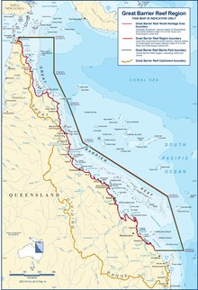
The Great Barrier Reef is the world's largest reef systems, stretching along the East coast of Australia from the northern tip down to the town of Bundaberg, is composed of roughly 2,900 individual reefs and 940 islands and cays that stretch for 2,300 kilometres (1,616 mi) and cover an area of approximately 344,400 square kilometres (133,000 sq mi). The reef is located in the Coral Sea, off the coast of Queensland in northeast Australia. A large part of the reef is protected by the Great Barrier Reef Marine Park.

According to the 2014 report of the Australian Government's Great Barrier Reef Marine Park Authority (GBRMPA), says that climate change is the most significant environmental threat to the Great Barrier Reef, while the other major environmental pressures are listed as decreased water quality from land-based runoff, impacts from coastal development and some persistent impacts from fishing activities. The reef is also threatened by storms, coral bleaching and ocean acidification. The 2014 report also shows that, while numerous marine life species have recovered after previous declines, the strength of the dugong population is continuing to decline. Terry Hughes, Federation Fellow, ARC Centre of Excellence for Coral Reef Studies at James Cook University, wrote in a 14 August 2014 Conversation piece that harmful government policies and ongoing conflicts of interest over mining royalties are risks of an equivalent magnitude.

The GBRMPA consider climate change, poor water quality, coastal development, and some impacts from fishing to be the area's major threats, but reef scientists Jon Day, Bob Pressey, Jon Brodie and Hughes stated that the "cumulative effects of many combined impacts" is the real issue.

In a Conversation article, Mathieu Mongin, a biogeochemical modeller at CSIRO and colleagues mapped parts of the Great Barrier Reef that are most exposed to ocean acidification. This map of pH on the Great Barrier Reef presents the exposure to ocean acidification on each of the 3,581 reefs, providing managers with the information they need to tailor management to individual reefs. The Great Barrier Reef is not a singular reef nor a physical barrier that prevents exchange between reefs; it is a mixture of thousands of productive reefs and shallow areas lying on a continental shelf with complex oceanic circulation.

History

In 1967, efforts began to conserve the Great Barrier Reef. It was proposed to mine lime from Ellison Reef, but surveys showed that the reef supported a diverse community of corals and fish.

The Australian and Queensland Governments committed to act in partnership in 2007 to protect the reef, and water quality monitoring programmes were implemented. However, the World Wildlife Fund criticised the slow progress of the governments, raising a concern that as many as 700 reefs continued to be at risk from sediment runoff.

The Australian government then outlined further action after the World Heritage Committee (WHC) called for the completion of a strategic assessment of the Reef area in 2011. The Committee also urged the government to use the assessment data to develop a long-term plan for protecting the "Outstanding Universal Value" of the reef, which is the basis for its World Heritage listing. Again, criticisms emerged from the expert community—due to vague quantitative targets, the absence of clear, specific strategies, and no mention of the implications of climate change—but the significant efforts of both state and federal governments addressed key recommendations from the WHC.

A 2012 UNESCO report, published by the WHC, then criticised the government's management of the Great Barrier Reef, warning that the area could be downgraded to a world heritage site "in danger" unless major changes were implemented. The report expressed "extreme concern" at the rapid rate of coastal development, highlighting the construction of liquefied natural gas plants at Gladstone and Curtis Island, and recommended that thorough assessments are made before any new developments that could affect the reef are approved. UNESCO specifically recommended no new port development in Abbot Point, Gladstone, Hay Point, Mackay, and Townsville.

Australian Foreign Minister Julie Bishop informed the Australian media that she would use climate change talks, held in Lima, Peru, in December 2014, to avoid the WHC—consisting of experts from 20 nations—applying the "in danger" listing in 2015. Bishop believed that "no justification" existed for the downgrading:

It would send a message around the world that even if you meet all of the criteria set out by the world heritage committee, there is still a risk that they will place an area on the in-danger list ... It [downgrading] would have significant implications for Australia but it would also set a very dangerous precedent for countries who don’t have the opportunity to take the action that Australia has.

To avoid the Great Barrier Reef being listed as "in danger", the Queensland Government introduced the Ports Bill 2014 on 25 November 2014. The Bill seeks to restrict further port development along the coast to Brisbane and four "Priority Port Development Areas", with the latter including four ports identified by the WHC in its 2012 report. The Bill also restricts dredging over a decade-long period, with the exception of priority ports. Additionally, a long-term sustainability plan and the expansion of water-quality activities were introduced by state and federal governments, and their partner agencies.

However, in response to the Ports Bill, University of Queensland (UQ) academics said on 19 December 2014 that, although the issues are "not insurmountable", "the health of the reef is still declining and consequently more needs to be done." Australian Marine Conservation Society (AMCS) Great Barrier Reef campaign director Felicity Wishart was more damning and stated in a press release:

The new Ports Bill fails to rule out any currently proposed new dredging, the dumping of dredge spoil in the Reef's waters and is silent on maintenance dredging across the region. The millions of tonnes of dredging and dumping for mega port developments that are in the pipeline will be able to go ahead under the Bill. Despite the establishment of four Priority Port Development Areas along the Reef (Townsville, Abbot Point, Mackay/Hay Point and Gladstone), the Bill will still allow port expansion in Cairns. This fails to meet the recommendation by the World Heritage Committee that no new port developments be permitted outside of the existing port areas. The Bill contains no protections for the most northern section of the Reef or the Fitzroy Delta, and it does nothing to improve water quality in Reef waters, all matters which the World Heritage Committee wants action on.

UNESCO considers that the Reef 2050 Long-Term Sustainability Plan has been effective, noting that progress had been made to reduce agricultural runoff sediments.

Water quality

Storage Silos on the Gladstone waterfront, an industrial area in the water catchment area

Water quality was first identified as a threat to the Great Barrier Reef in 1989. Thirty "major rivers" and hundreds of small streams comprise the Great Barrier Reef catchment area, which covers 423,000 square kilometres (163,000 sq mi) of land. Queensland has several major urban centers on the coast including Cairns, Townsville, Mackay, Rockhampton and the industrial city of Gladstone. Dredging in the Port of Gladstone is raising concern after dead and diseased fish where found in the harbor. Cairns and Townsville are the largest of the coastal cities, with populations of approximately 150,000 each.

There are many major water quality variables affecting coral reef health including water temperature, salinity, nutrients, suspended sediment concentrations, and pesticides. The species in the Great Barrier Reef area are adapted to tolerable variations in water quality however when critical thresholds are exceeded they may be adversely impacted. River discharges are the single biggest source of nutrients, providing significant pollution of the Reef during tropical flood events with over 90% of this pollution being sourced from farms. When the 2019 Townsville flood waters reached the Great Barrier Reef, the flood plumes covered a large area of corals, even reaching 60 km out to sea, however water quality analysis showed damage to the outer reef from the flooding was less than previously feared.

As of 1995, water visibility had decreased to 10 metres.

Due to the range of human uses made of the water catchment area adjacent to the Great Barrier Reef, some 700 of the 3,000 reefs are within a risk zone where water quality has declined due to the naturally acidic sediment and chemical runoff from farming. Coastal development and the loss of coastal wetlands—the latter acts as natural filter—are also major factors From mid 2012 to mid 2016, 596,000 hectares of forest in the catchment zone was cleared.

Trichodesmium bloom off the Great Barrier Reef

Industries in the water catchment area are cotton growing, comprising approximately 262 km2 (101 sq mi); 340 dairy farms with an average area of 2 km2 (0.77 sq mi) each, 158 km2 (61 sq mi) cattle grazing, 288 km2 (111 sq mi) horticulture including banana growing, sugarcane farming, and cropping of approximately 8,000 km2 (3,100 sq mi) wheat, 1,200 km2 (460 sq mi) barley, and 6,000 to 7000 km2 sorghum and maize. Fertiliser use in the cotton, dairy, beef, horticulture and sugar industries is essential to ensure productivity and profitability. However, fertiliser and byproducts from sugar cane harvesting methods form a component of surface runoff into the Great Barrier Reef lagoon.

The principal agricultural activity in the wet tropics is sugar cane farming, while cattle grazing is the primary industry in the dry tropics regions. Both are considered significant threats to high water quality. Copper, a common industrial pollutant in the waters of the Great Barrier Reef, has been shown to interfere with the development of coral polyps.

Flood plumes are flooding events associated with higher levels of nitrogen and phosphorus. In February 2007, due to a monsoonal climate system, plumes of sediment runoff have been observed reaching to the out most regions of the reef.

Runoff is especially concerning in the region south of Cairns, as it receives over 3,000 millimetres (120 in) of rain per year and the reefs are less than 30 kilometres (19 mi) away from the coastline. Farm run off is polluted as a result of overgrazing and excessive fertilizer and pesticide use. Mud pollution has increased by 800% and inorganic nitrogen pollution by 3,000% since the introduction of European farming practices on the Australian landscape. This pollution has been linked to a range of very significant risks to the reef system, including intensified outbreaks of the coral-eating crown-of-thorns starfish which contributed to a loss of 66% of live coral cover on sampled reefs in 2000.

It is thought that the mechanism behind excess nutrients affecting the reefs is due to increased light and oxygen competition from algae, but unless herbivory is unusually low, this will not create a phase shift from the Great Barrier Reef being primarily made up of coral to being primarily made up of algae.

Acropora with brown band disease, Lizard Island

It has been suggested that poor water quality due to excess nutrients encourages the spread of infectious diseases among corals. In general, the Great Barrier Reef is considered to have low incidences of coral diseases. Skeletal Eroding Band, a disease of bony corals caused by the protozoan Halofolliculina corallasia, affects 31 species of corals from six families on the reef. The long-term monitoring program has found an increase in incidences of coral disease in the period 1999–2002, although they dispute the claim that on the Great Barrier Reef, coral diseases are caused by anthropogenic pollution.

Elevated nutrient concentrations result in a range of impacts on coral communities and under extreme conditions can result in a collapse. It also affects coral by promoting phytoplankton growth which increases the number of filter-feeding organisms that compete for space. Excessive inputs of sediment from land to coral can lead to reef destruction through burial, disruption of recruitment success, or deleterious community shifts. Sediments affect coral by smothering them when particles settle out, reducing light availability and potentially reducing photosynthesis and growth. Coral reefs exist in seawater salinities from 25 to 42%. Salinity impacts to corals are increased by other flood-related stresses.

Pollution from mining

A protest against the Adani Carmichael mine, 2016

A freedom of information request by the Northern Queensland Conservation Council in 2014 showed that Queensland Nickel, owned by Australian politician Clive Palmer, discharged nitrate-laden water into the Great Barrier Reef in 2009 and 2011—releasing 516 tonnes (508 long tons; 569 short tons) of toxic waste water on the latter occasion. In June 2012, Queensland Nickel stated it intended to release waste water, continuously for three months, "at least 100 times the allowed maximum level as well as heavy metals and other contaminants". A GBRMPA briefing stated the company had "threatened a compensation claim of $6.4bn should the GBRMPA intend to exert authority over the company's operations". In response to the publicisation of the dumping incidents, the GBRMPA stated:

We have strongly encouraged the company to investigate options that do not entail releasing the material to the environment and to develop a management plan to eliminate this potential hazard; however, GBRMPA does not have legislative control over how the Yabulu tailings dam is managed.

Dumping

Following a tour of the Great Barrier Reef area by WHC members, a 2012 UNESCO report, which criticised management of the Great Barrier Reef, specifically recommended no new port development outside the established areas of Abbot Point, Gladstone, Hay Point/Mackay, and Townsville. However, in December 2013, Greg Hunt, the Australian environment minister, approved a plan for dredging to create three shipping terminals as part of the construction of a coalport. According to corresponding approval documents, the process will create around 3 million cubic metres of dredged seabed that will be dumped within the Great Barrier Reef marine park area.

Catchments along the Great Barrier Reef

On 31 January 2014, the GBRMPA issued a dumping permit that will allow three million cubic metres of sea bed from Abbot Point, north of Bowen, to be transported and unloaded in the waters of the Great Barrier Reef Marine Park. Potential significant harms have been identified in relation to dredge spoil and the process of churning up the sea floor in the area and exposing it to air: firstly, new research shows the finer particles of dredge spoil can cloud the water and block sunlight, thereby starving sea grass and coral up to distances of 80 km away from the point of origin due to the actions of wind and currents. Furthermore, dredge spoil can literally smother reef or sea grass to death, while storms can repeatedly resuspend these particles so that the harm caused is ongoing; secondly, disturbed sea floor can release toxic substances into the surrounding environment.

The dredge spoil from the Abbot Point port project is to be dumped 24 kilometres (15 mi) away, near Bowen in north Queensland, and the approval from the Authority will result in the production of an extra 70 million tonnes of coal annually, worth between A$1.4 billion and $2.8 billion. Authority chairman, Dr Russell Reichelt, stated after the confirmation of the approval:

This approval is in line with the agency's view that port development along the Great Barrier Reef coastline should be limited to existing ports. As a deepwater port that has been in operation for nearly 30 years, Abbot Point is better placed than other ports along the Great Barrier Reef coastline to undertake expansion as the capital and maintenance dredging required will be significantly less than what would be required in other areas. It's important to note the seafloor of the approved disposal area consists of sand, silt and clay and does not contain coral reefs or seagrass beds.

The approval was provided with a corresponding set of 47 new environmental conditions that include the following:

  • A long-term water quality monitoring plan extending five years after the disposal activity is completed.
  • A heritage management plan to protect the Catalina second world war aircraft wreck in Abbot Bay.
  • The establishment of an independent dredging and disposal technical advice panel and a management response group, to include community representatives.

Numerous responses, including online petitions, were published in opposition to the proposal: Greenpeace launched the "Save the Reef" campaign in opposition to the dumping, which remained active with over 170,000 signatures on 3 March 2014; in addition to an online petition that registered more than 250,000 signatures on 3 March 2014, political activist group GetUp! are also funding a legal case in conjunction with non-profit Environmental Defenders Office of Queensland (EDO), which represents the North Queensland Conservation Council; and "Fight for the Reef", a partnership between World Wide Fund for Nature (WWF)-Australia and the Australian Marine Conservation Society (AMCS), maintains a campaign that collects online donations to fund a "legal fighting team", and displayed nearly 60,000 supporters on its website on 11 May 2014.

The legal fighting team of the WWF-Australia and the AMCS received further support in April 2014 following the release of the "Sounds for the Reef" musical fundraising project. Produced by Straightup, the digital album features artists such as John Butler, The Herd, Sietta, Missy Higgins, The Cat Empire, Fat Freddys Drop, The Bamboos (featuring Kylie Auldist) and Resin Dogs. Released on 7 April, the album's 21 songs were sold on the Bandcamp website.

Further support for the WWF-Australia and AMCS partnership occurred in late April 2014, when the Ben & Jerry's ice cream company signed onto the "Fight for the Reef" campaign. In early April 2014, the company withdrew the popular "Phish Food" flavour in Australia due to the aquatic association and the potential for awareness-raising. The product withdrawal decision followed tours around select parts of the nation that involved Ben & Jerry's representatives distributing free ice cream to highlight the reef damage issue.

In response, Minister for the Environment and Heritage Protection of Queensland Andrew Powell said that he would be contacting parent corporation Unilever, explaining, "The only people taking a scoop out of the reef is Ben and Jerry's and Unilever. If you understand the facts, you'd want to be boycotting Ben and Jerry's". The Australian public was also informed by Australian Ben & Jerry's brand manager Kalli Swaik, who stated to the Brisbane Times newspaper: "Ben & Jerry's believes that dredging and dumping in world heritage waters surrounding the marine park area will be detrimental to the reef ecology. It threatens the health of one of Australia's most iconic treasures."

A Queensland state senator, Matthew Canavan, confirmed that he raised the issue in writing with the Australian Competition and Consumer Commission (ACCC) and said to The Courier-Mail:

Ben & Jerry's can campaign on whatever issue they like but as a company they have an obligation to tell Australians the whole truth and nothing but the truth. Australia has strict laws to protect consumers against misleading and deceptive behavior. These mistruths could cost jobs and development in regional Queensland. It's irresponsible behavior from a company that should know better.

In 2015 the mining industry generated proposals for 5 additional port developments outside the existing ports. In response the Great Barrier Reef Marine Park Authority proposed a ban on disposal of all capital works dredge spoil in the GBR Marine Park, including the yet to be commenced Abbot Point development. This regulation change to the Great Barrier Reef Marine Park Act 1975 was enacted in 2015.

After Cyclone Debbie in 2017, the Adani-operated port released water with eight times the permitted sediment into the Abbot Point lagoon.

Climate change

Sea temperature and bleaching of the Great Barrier Reef
 

According to the GBRMPA in 2014, the most significant threat to the status of the Great Barrier Reef is climate change, due to the consequential rise of sea temperatures, gradual ocean acidification and an increase in the number of "intense weather events". Hughes writes of "the demonstrable failure of the state and Commonwealth" to address the issue of climate change in his August 2014 article. Furthermore, a temperature rise of between two and three degrees Celsius would result in 97% of the Great Barrier Reef being bleached every year.

Reef scientist Terry Done has predicted that a one-degree rise in global temperature would result in 82% of the reef bleached—two degrees would result in 97%, while three degrees would result in "total devastation". A predictive model based on the 1998 and 2002 bleaching events has concurred that a temperature rise of three degrees would result in total coral mortality.

However, a few scientists hold that coral bleaching may in some cases be less of a problem than the mainstream believes. Professor Peter Ridd, from James Cook University in Townsville was quoted in The Australian (a conservative newspaper) as saying; "They are saying bleaching is the end of the world, but when you look into it, that is a highly dubious proposition". Research by scientist Ray Berkelmans "... has documented astonishing levels of recovery on the Keppel outcrops devastated by bleaching in 2006." A related article in The Australian newspaper goes on to explain that; "Those that expel their zooxanthellae have a narrow opening to recolonise with new, temperature-resistant algae before succumbing. In the Keppels in 2006, Berkelmans and his team noticed that the dominant strain of zooxanthellae changed from light and heat-sensitive type C2, to more robust types D and C1."

Nevertheless, most coral reef researchers anticipate severely negative effects from climate change already occurring, and potentially disastrous effects as climate change worsens. The future of the Reef may well depend on how much the planet's climate changes, and thus, on how high atmospheric greenhouse gas concentration levels are allowed to rise. On 2 September 2009, a report by the Australian Great Barrier Reef Marine Park Authority revealed that if carbon dioxide levels reached 450 parts per million corals and reef habitats will be highly vulnerable. If carbon dioxide levels are managed at or below 380 parts per million they will be only moderately vulnerable and the reefs will remain coral-dominated.

Global warming may have triggered the collapse of reef ecosystems throughout the tropics. Increased global temperatures are thought by some to bring more violent tropical storms, but reef systems are naturally resilient and recover from storm battering. Most people agree that an upward trend in temperature will cause much more coral bleaching; others suggest that while reefs may die in certain areas, other areas will become habitable for corals, and new reefs will form. However, the rate at which the mass bleaching events occur is estimated to be much faster than reefs can recover from, or adjust to.

However, Kleypas et al. in their 2006 report suggest that the trend towards ocean acidification indicates that as the sea's pH decreases, corals will become less able to secrete calcium carbonate. In 2009, a study showed that Porites corals, the most robust on the Great Barrier Reef, have slowed down their growth by 14.2% since 1990. It suggested that the cause was heat stress and a lower availability of dissolved calcium to the corals.

Climate change has implications for other forms of life on the Great Barrier Reef as well – some fishes' preferred temperature range lead them to seek new areas to live, thus causing chick mortality in seabirds that prey on the fish. Also, in sea turtles, higher temperatures mean that the sex ratio of their populations will change, as the sex of sea turtles is determined by temperature. The habitat of sea turtles will also shrink. A 2018 study which compared the sex ratio of green sea turtles in the northern and southern populations found that the northern population was almost all female.

On 22 April 2018 scientists expressed alarm that the impact of climate change could cause massive damage to the ecosystem.

The Great Barrier Reef "glue" is at risk from ocean acidification: a study in 2020 argues that in the present-day context of rapid global climate change, changes in dissolved carbon dioxide, pH and temperature, could lead to reduced microbial crust formation, thereby weakening reef frameworks in the future. The study involved extensive sampling of the Great Barrier Reef fossil record and has shown that the calcified scaffolds that help stabilize and bind its structure become thin and weaker as pH levels fall.

Crown-of-thorns starfish

Crown-of-thorns starfish and eaten coral off the coast of Cooktown, Queensland

The crown-of-thorns starfish is a coral reef predator which preys on coral polyps by climbing onto them, extruding its stomach over them, and releasing digestive enzymes to absorb the liquefied tissue. An individual adult of this species can eat up to six square meters of living reef in a single year. Geological evidence suggests that the crown-of-thorns starfish has been part of the Great Barrier Reef's ecology for "at least several thousand years", but there is no geological evidence for crown-of-thorns outbreaks. The first known outbreak occurred during the 1960s. Large outbreaks of these starfish can devastate reefs. In 2000, an outbreak contributed to a loss of 66% of live coral cover on sampled reefs in a study by the CRC Reefs Research Centre. Although large outbreaks of these starfish are believed to occur in natural cycles, human activity in and around the Great Barrier Reef can worsen the effects. Reduction of water quality associated with agriculture can cause the crown-of-thorns starfish larvae to thrive. Fertilizer runoff from farming increases the amount of phytoplankton available for the crown-of-thorns starfish larvae to consume. A study by the Australian Institute of Marine Science showed that a doubling of the chlorophyll in the water leads to a tenfold increase in the crown-of-thorns starfish larvae's survival rate. Overfishing of its natural predators, such as the Giant Triton, is also considered to contribute to an increase in the number of crown-of-thorns starfish. The CRC Reef Research Centre defines an outbreak as when there are more than 30 adult starfish in an area of one hectare. There have been three large outbreaks of COTS on the reef since observation began, between 1962 and 1976; 1978 and 1991; 1993 and 2005, and a fourth began in 2009. Investigation is being undertaken into mimicking a chemical scent released by the COTS' natural predator, the giant triton snail.

Overfishing

The unsustainable overfishing of keystone species, such as the Giant Triton and sharks, can cause disruption to food chains vital to life on the reef. Fishing also impacts the reef through increased pollution from boats, bycatch of unwanted species (such as dolphins and turtles) and reef habitat destruction from trawling, anchors and nets. Overfishing of herbivore populations can cause algal growths on reefs. The batfish Platax pinnatus has been observed to significantly reduce algal growths in studies simulating overfishing. Sharks are fished for their meat, and when they are part of bycatch, it is common to kill the shark and throw it overboard, as there is a belief that they interfere with fishing. As of 1 July 2004, approximately one-third of the Great Barrier Reef Marine Park is protected from species removal of any kind, including fishing, without written permission. However, illegal poaching is not unknown in these no-take zones. A 2015 study into coral trout on the Great Barrier Reef found that the no-take zones had more coral trout and more coral trout larvae after tropical cyclone events, which helped replenish those areas sooner. The GBRMPA has a hotline to report suspected poachers.

Shark culling

The government of Queensland has a "shark control" program (shark culling) that deliberately kills sharks in Queensland, including in the Great Barrier Reef. Environmentalists and scientists say that this program harms the marine ecosystem; they also say it is "outdated, cruel and ineffective". The Queensland "shark control" program uses shark nets and drum lines with baited hooks to kill sharks in the Great Barrier Reef – as of 2018, there are 173 lethal drum lines in the Great Barrier Reef. In Queensland, sharks found alive on the baited hooks are shot. Queensland's "shark control" program killed about 50,000 sharks from 1962 to 2018. In addition, Queensland's "shark control" program has killed many other animals (such as dolphins and turtles) – the program killed 84,000 marine animals from 1962 to 2015, including in the Great Barrier Reef.

In 2018, Humane Society International filed a lawsuit against the government of Queensland to stop shark culling in the Great Barrier Reef. In 2019, a court (tribunal) said the lethal practices had to stop, but the government of Queensland resumed shark-killing in the Great Barrier Reef when they appealed the decision. The litigation is ongoing.

Shipping

The Shen Neng 1 aground on the Great Barrier Reef, 5 April 2010

Shipping accidents continue to be perceived as a threat, as several commercial shipping routes pass through the Great Barrier Reef. The GBRMPA estimates that about 6000 vessels greater than 50 metres (164 ft) in length use the Great Barrier Reef as a route. From 1985 to 2001, 11 collisions and 20 groundings occurred along the Great Barrier Reef shipping route, with human error identified as the leading cause of shipping accidents.

Reef pilots have stated that they consider the reef route safer than outside the reef in the event of mechanical failure, since a ship can sit safely while being repaired. The inner route is used by 75% of all ships that travel over the Great Barrier Reef. As of 2007, over 1,600 known shipwrecks have occurred in the Great Barrier Reef region.

Waste and foreign species discharged from ships in ballast water (when purging procedures are not followed) are a biological hazard to the Great Barrier Reef. Tributyltin (TBT) compounds found in some antifouling paint on ship hulls leaches into seawater and is toxic to marine organisms and humans; as of 2002, efforts are underway to restrict its use.

In April 2010, the bulk coal carrier Shen Neng 1 ran aground on the Great Barrier Reef, causing the largest grounding scar to date. The spill caused damage to a 400,000sqm section of the Great Barrier Reef and the use of oil dispersant resulted in oil spreading to reef islands 25 km away. In 2012 and 2013, there were 9619 ship voyages through the Great Barrier Reef region, and this is forecast to increase 250% over the next 20 years.

Over 9,600 ship voyages occurred in the GBRMPA between 2012 and 2013.

Oil

It was suspected that the Great Barrier Reef is the cap to an oil trap, after a 1923 paper suggested that it had the right rock formation to support "oilfields of great magnitude". After the Commonwealth Petroleum Search Subsidies Act of 1957, exploration activities increased in Queensland, including a well drilled at Wreck Island in the southern Great Barrier Reef in 1959. In the 1960s, drilling for oil and gas was investigated throughout the Great Barrier Reef, by seismic and magnetic methods in the Torres Strait, along "the eastern seaboard of Cape York to Princess Charlotte Bay" and along the coast from Cooktown to Fraser Island. In the late 1960s, more exploratory wells were drilled near Wreck Island in the Capricorn Channel, and near Darnley Island in the Torres Strait, but "all results were dry".

In 1970, responding to concern about oil spills such as the Torrey Canyon, two Royal Commissions were ordered "into exploratory and production drilling for petroleum in the area of the Great Barrier Reef". After the Royal Commissions, the federal and state governments ceased allowing petroleum drilling on the Great Barrier Reef. A study in 1990 concluded that the reef is too young to contain oil reserves. Oil drilling remains prohibited on the Great Barrier Reef, yet oil spills due to shipping routes are still a threat to the reef system, with a total of 282 oil spills between 1987 and 2002.

Tropical cyclones

Tropical Cyclone Larry over the Great Barrier Reef, 19 March 2006

Tropical cyclones are a cause of ecological disturbance to the Great Barrier Reef. The types of damage caused by tropical cyclones to the Great Barrier Reef is varied, including fragmentation, sediment plumes, and decreasing salinity following heavy rains (Cyclone Joy). The patterns of reef damage are similarly "patchy". From 1910 to 1999, 170 cyclones' paths came near or through the Great Barrier Reef. Most cyclones pass through the Great Barrier Reef within a day. In general, compact corals such as Porites fare better than branching corals under cyclone conditions. The major damage caused by Tropical Cyclone Larry was to underlying reef structures, and breakage and displacement of corals, which is overall consistent with previous tropical cyclone events. Severe tropical cyclones hit the Queensland coast every 200 to 300 years; however, during the period 1969–1999 most cyclones in the region were very weak – category one or two on the Australian Bureau of Meteorology scale.

On 2 February 2011, Severe Tropical Cyclone Yasi struck northern Queensland and caused severe damage to a stretch of hundreds of kilometres within the Great Barrier Reef. The corals could take a decade to recover fully. Cyclone Yasi had wind speeds of 290 kilometers per hour.

Great Barrier Reef Marine Park

From Wikipedia, the free encyclopedia
 
Great Barrier Reef Marine Park
Queensland
Jack Barnes Bicentennial Mangrove Boardwalk.jpg
Boardwalk through a mangrove forest featured in Estuarine Conservation Zone as part of The Great Barrier Reef Marine Park
Great Barrier Reef Marine Park is located in Queensland
Great Barrier Reef Marine Park
Coordinates18°34′4″S 148°33′19″ECoordinates: 18°34′4″S 148°33′19″E
Established1975
Area343,966 km2 (132,806.0 sq mi)
Managing authorities
WebsiteGreat Barrier Reef Marine Park

The Great Barrier Reef Marine Park protects a large part of Australia's Great Barrier Reef from damaging activities. It is a vast multiple-use Marine Park which supports a wide range of uses, including commercial marine tourism, fishing, ports and shipping, recreation, scientific research and Indigenous traditional use. Fishing and the removal of artefacts or wildlife (fish, coral, seashells, etc.) is strictly regulated, and commercial shipping traffic must stick to certain specific defined shipping routes that avoid the most sensitive areas of the park. The Great Barrier Reef is the largest and best known coral reef ecosystem in the world. Its reefs, almost 3000 in total, represent about 10 per cent of all the coral reef areas in the world. It supports an amazing variety of biodiversity, providing a home to thousands of coral and other invertebrate species, bony fish, sharks, rays, marine mammals, marine turtles, sea snakes, as well as algae and other marine plants.

Managing authority

The Great Barrier Reef Marine Park Authority (GBRMPA) is responsible for the care and protection of the Great Barrier Reef Marine Park. It uses a range of tools to manage the marine park including Acts and Regulations, zoning plan, plans of management, traditional owner agreements, partnerships, stewardship and best practice, education, research and monitoring and reporting. It issues permits for various forms of use of the marine park, and monitors usage in the park to ensure compliance with rules and regulations associated with the park. GBRMPA is funded by Commonwealth Government appropriations and an environmental management charge levied on the permit-holders' passengers. Currently this is A$6.00 per day per passenger (to a maximum of $16.50 per trip).

In May 2022 the Darumbal people were officially recognised as the traditional custodians of an expanse of ocean covering 36,606 km2 (14,134 sq mi) off the Central Queensland Coast, making it the largest Traditional Use of Marine Resources Agreement (TUMRA) on the reef. The agreement created a partnership with GBRMPA and Queensland's Department of Environment and Science. The occasion was marked by a ceremony on the beach at Emu Park.

Description

Extent

Map of The Great Barrier Reef Region, World Heritage Area and Marine Park, 2014

The marine park lies east of the mainland coast of Queensland, starting in the north at Cape York. Its northern boundary is the circle of latitude 10°41'S (running east up to the eastern edge of the Great Barrier Reef at 145º19'33"E), thereby encompassing those few uninhabited Torres Strait Islands that are east of Cape York, south of 10°41'S and north of 11°00'S. The largest of those island are Albany Island (5.9 km2 or 2.3 sq mi), Turtle Head Island 12.8 km2 or 4.9 sq mi and Trochus Island 2.2 km2 or 0.85 sq mi. Further islands are Mai Island 0.25 km2 or 0.097 sq mi, Bush Island 0.2 km2 or 0.077 sq mi, Tree Islet 0.01 km2 or 0.0039 sq mi, Brewis Island 0.05 km2 or 0.019 sq mi, and a few unnamed islets.

Its southern boundary lies south of Gladstone and north of Bundaberg, taking in Lady Elliot Island.

Protected area designation

As of 2016, zones within the marine park has been categorized into the following IUCN protected area categories:

  • IUCN Category Ia with an area of 859 square kilometres (332 sq mi) being about 0.2% of the marine park's area,
  • IUCN Category II with an area of 114,309 square kilometres (44,135 sq mi) being about 33%,
  • IUCN Category IV with an area of 15,027 square kilometres (5,802 sq mi) being about 4% and
  • IUCN Category VI with an area of 213,769 square kilometres (82,537 sq mi) being about 62%.

History

In 1975, the Government of Australia enacted the Great Barrier Reef Marine Park Act 1975, which created the Great Barrier Reef Marine Park Authority, and defined what acts were prohibited on the Reef. Joe Baker, who was involved in the bid to make the Great Barrier Reef World Heritage-listed in 1981, was a founding member of the Great Barrier Reef Marine Park Authority.

The Australian Government also has recognised the ecological significance of this Park by its inclusion in the nation's Biodiversity Action Plan. The Government of Australia manages the reef through the Great Barrier Reef Marine Park Authority and in partnership with the Government of Queensland, to ensure that it is widely understood and used in a sustainable manner. A combination of zoning, management plans, permits, education and incentives (such as eco-tourism certification) is used in the effort to conserve the Great Barrier Reef.

As many species of the Great Barrier Reef are migratory, many international, national, and interstate conventions or pieces of legislation must be taken into account when strategies for conservation are made.

Some international conventions that the Great Barrier Reef Marine Park must follow are: the Bonn Convention, Ramsar Site (for the Bowling Green Bay National Park site), CITES, JAMBA and CAMBA. Some national legislation that the Park must follow are: Great Barrier Reef Marine Park Act 1975, Environment Protection and Biodiversity Conservation Act 1999, National Strategy for Ecologically Sustainable Development, National Strategy for the Conservation of Australia's Biological Diversity, Australia's Oceans Policy, National Strategy for the Conservation of Australian Species and Communities Threatened with Extinction. Some state legislation that the Park must follow are: Nature Conservation Act 1992, Marine Parks Act 1982, Fisheries Act 1994, Queensland Nature Conservation (Wildlife) Regulation 1994.

For example, the Queensland Government has enacted several plans attempting to regulate fishing. The East Coast Trawl Management Plan 1999 aimed to regulate trawling through limiting the times when trawling is permitted and restricting gear used. The Fisheries (Coral Reef Fin Fish Fishery) Management Plan 2003 aimed at reducing the annual commercial catch to 1996 levels, disallowing fishing when the fish are spawning and increasing the minimum legal size of fish.

The Great Barrier Reef was selected as a World Heritage Site in 1981. Up until 1999, there were four main zones in the Great Barrier Reef Marine Park. They were the "Far Northern", "Cairns", "Central" and "Mackay/Capricorn" sections. These zoning sections were created between 1983 and 1987. Another section, the "Gumoo Woojabuddee" section was declared in 1998. Each section had its own zoning plan. The Great Barrier Marine Park Zoning Plan 2003 superseded all previous zoning plans, coming into effect on 1 July 2004.

In July 2004, a new zoning plan was brought into effect for the entire Marine Park, and has been widely acclaimed as a new global benchmark for the conservation of marine ecosystems. The rezoning was based on the application of systematic conservation planning techniques, using the MARXAN software. On 1 July 2004 the Great Barrier Reef Marine Park became the largest protected sea area in the world when the Australian Government increased the areas protected from extractive activities (such as fishing) from 4.6% to 33.3% of the park. As of 2006, the Northwestern Hawaiian Islands National Monument is the largest protected marine area in the world. The management committee draws inspiration from the Great Barrier Reef Marine Park Authority's management strategies.

The current method of zoning is called the "Representative Areas Program", which chooses "typical" areas of the Great Barrier Reef Marine Park. They can then be protected in "Green Zones" (no-take zones). The Great Barrier Reef World Heritage Area has been divided into 70 bioregions, of which 30 are reef bioregions, and 40 are non-reef bioregions.

In 2006, a review was undertaken of the Great Barrier Reef Marine Park Act 1975. Some recommendations of the review are that there should be no further zoning plan changes until 2013, and that every five years, a peer-reviewed Outlook Report should be published, examining the health of the Great Barrier Reef, the management of the Reef, and environmental pressures.

In early 2007, GBRMPA was one of three nominees for the Destination Award in the World Travel and Tourism Council's Tourism for Tomorrow Awards.

On 3 April 2010, the Shen Neng 1, a Chinese ship carrying 950 tonnes of oil, ran aground, causing the 2010 Great Barrier Reef oil spill.

In 2012, legislation was introduced which compelled developers to deposit money into the Reef Trust. Professor Tiffany Morrison argues that this has made it easier for developments to be approved in the region.

The week before 21 July 2013, on the second day of the biennial joint training exercise Talisman Saber, two American AV-8B Harrier fighter jets launched from aircraft carrier USS Bonhomme Richard (LHD-6) dropped four bombs, weighing a total 1.8 metric tons (4,000 pounds), into more than 50 metres (164 ft) of water. None exploded and no coral was damaged.

People such as scientists, conservationists, developers, managers, tourism entrepreneurs and politicians have had major influences on the history of the reef In 2015, the Australian Government and Reef Ecologic Pty Ltd conducted a coral reef training course to build capacity to protect coral reefs.

Threats

Crown-of-thorns starfish

The crown-of-thorns starfish (Acanthaster planci), while native to the reef, poses one of its greatest threats when outbreaks occur. Several efforts have been made to identify and control these outbreaks, including the COTSBot developed by Queensland University of Technology.

These outbreaks and subsequent threats have led to an increase in awareness and appearances in mainstream media, as industry and conservation groups try to control the COTS and protect the reef. An infographic explaining the process of identifying and targeting this threat can be seen here.

Outlook for the Reef

The Great Barrier Reef Outlook Report 2014, published every five years, examines the Great Barrier Reef's health, pressures, and likely future.

The report is required under Great Barrier Reef Marine Park Act 1975 (section 54) and aims to provide a regular and reliable means of assessing reef health and management in an accountable and transparent way.

The report finds the greatest risks to the Reef are still climate change, land-based run-off, coastal development, some fishing impacts, illegal fishing and poaching.

Associated protected areas

The Great Barrier Reef Coast Marine Park is a marine protected area located in Queensland waters adjoining the Great Barrier Reef. It was created on 5 November 2004 by the amalgamation of the following former marine parks – the Mackay/Capricorn Marine Park, the Townville/Whitsunday Marine Park, the Trinity Inlet/ Marlin Coast Marine Park and the Cairns Marine Park, along with the addition of previously unprotected area of coastal water that adjoined the former marine parks listed above. The marine park is intended to complement the adjoining GBRMP by the use of "similar zone objectives, and entry and use provisions". It is managed by the Queensland Parks and Wildlife Service.

Environmental protection

From Wikipedia, the free encyclopedia
 
Clean Ocean Project poster

Environmental protection is the practice of protecting the natural environment by individuals, organizations and governments. Its objectives are to conserve natural resources and the existing natural environment and, where possible, to repair damage and reverse trends.

Due to the pressures of overconsumption, population growth and technology, the biophysical environment is being degraded, sometimes permanently. This has been recognized, and governments have begun placing restraints on activities that cause environmental degradation. Since the 1960s, environmental movements have created more awareness of the multiple environmental problems. There is disagreement on the extent of the environmental impact of human activity, so protection measures are occasionally debated.

Approaches to environmental protection

Voluntary environmental agreements

In the industrial countries, voluntary environmental agreements often provide a platform for companies to be recognized for moving beyond the minimum regulatory standards and thus support the development of the best environmental practice. For instance, in India, Environment Improvement Trust (EIT) has been working for environmental and forest protection since 1998. In developing countries, such as Latin America, these agreements are more commonly used to remedy significant levels of non-compliance with mandatory regulation.

Ecosystems approach

An ecosystems approach to resource management and environmental protection aims to consider the complex interrelationships of an entire ecosystem in decision making rather than simply responding to specific issues and challenges. Ideally, the decision-making processes under such an approach would be a collaborative approach to planning and decision making that involves a broad range of stakeholders across all relevant governmental departments, as well as industry representatives, environmental groups, and community. This approach ideally supports a better exchange of information, development of conflict-resolution strategies and improved regional conservation. Religions also play an important role in the conservation of the environment.

International environmental agreements

Kyoto Protocol Commitment map 2010

Many of the earth's resources are especially vulnerable because they are influenced by human impacts across different countries. As a result of this, many attempts are made by countries to develop agreements that are signed by multiple governments to prevent damage or manage the impacts of human activity on natural resources. This can include agreements that impact factors such as climate, oceans, rivers and air pollution. These international environmental agreements are sometimes legally binding documents that have legal implications when they are not followed and, at other times, are more agreements in principle or are for use as codes of conduct. These agreements have a long history with some multinational agreements being in place from as early as 1910 in Europe, America and Africa.

Many of the international technical agencies formed after 1945 addressed environmental themes. By the late 1960s, a growing environmental movement called for coordinated and institutionalized international cooperation. The landmark United Nations Conference on the Human Environment was held in Stockholm in 1972, establishing the concept of a right to a healthy environment. It was followed by the creation of the United Nations Environment Programme later that year. Some of the most well-known international agreements include the Kyoto Protocol of 1997 and the Paris Agreement of 2015.

On 8 October 2021, the UN Human Rights Council passed a resolution recognizing access to a healthy and sustainable environment as a universal right. In the resolution 48/13, the Council called on States around the world to work together, and with other partners, to implement the newly recognized right.

On 28 July 2022, the United Nations General Assembly voted to declare the ability to live in “a clean, healthy and sustainable environment” a universal human right. UN High Commissioner for Human Rights Michelle Bachelet hailed the decision and called for urgent action to make it a reality for all.

Government

Top five countries by biological diversity

Discussion concerning environmental protection often focuses on the role of government, legislation, and law enforcement. However, in its broadest sense, environmental protection may be seen to be the responsibility of all the people and not simply that of government. Decisions that impact the environment will ideally involve a broad range of stakeholders including industry, indigenous groups, environmental group and community representatives. Gradually, environmental decision-making processes are evolving to reflect this broad base of stakeholders and are becoming more collaborative in many countries.

Tanzania

Many constitutions acknowledge Tanzania as having some of the greatest biodiversity of any African country. Almost 40% of the land has been established into a network of protected areas, including several national parks. The concerns for the natural environment include damage to ecosystems and loss of habitat resulting from population growth, expansion of subsistence agriculture, pollution, timber extraction and significant use of timber as fuel.

Environmental protection in Tanzania began during the German occupation of East Africa (1884-1919)—colonial conservation laws for the protection of game and forests were enacted, whereby restrictions were placed upon traditional indigenous activities such as hunting, firewood collecting, and cattle grazing. In 1948, Serengeti has officially established the first national park for wild cats in East Africa. Since 1983, there has been a more broad-reaching effort to manage environmental issues at a national level, through the establishment of the National Environment Management Council (NEMC) and the development of an environmental act.

Zebras at the Serengeti savana plains in northern part of Tanzania

Division of the biosphere is the main government body that oversees protection. It does this through the formulation of policy, coordinating and monitoring environmental issues, environmental planning and policy-oriented environmental research. The National Environment Management Council (NEMC) is an institution that was initiated when the National Environment Management Act was first introduced in year 1983. This council has the role to advise governments and the international community on a range of environmental issues. The NEMC the following purposes: provide technical advice; coordinate technical activities; develop enforcement guidelines and procedures; assess, monitor and evaluate activities that impact the environment; promote and assist environmental information and communication; and seek advancement of scientific knowledge.

The National Environment Policy of 1997 acts as a framework for environmental decision making in Tanzania. The policy objectives are to achieve the following:

  • Ensure sustainable and equitable use of resources without degrading the environment or risking health or safety.
  • Prevent and control degradation of land, water, vegetation and air.
  • Conserve and enhance natural and man-made heritage, including biological diversity of unique ecosystems.
  • Improve condition and productivity of degraded areas.
  • Raise awareness and understanding of the link between environment and development.
  • Promote individual and community participation.
  • Promote international cooperation.
  • Use ecofriendly resources.

Tanzania is a signatory to a significant number of international conventions including the Rio Declaration on Development and Environment 1992 and the Convention on Biological Diversity 1996. The Environmental Management Act, 2004, is the first comprehensive legal and institutional framework to guide environmental-management decisions. The policy tools that are parts of the act include the use of environmental-impact assessments, strategics environmental assessments, and taxation on pollution for specific industries and products. The effectiveness of shifting of this act will only become clear over time as concerns regarding its implementation become apparent based on the fact that, historically, there has been a lack of capacity to enforce environmental laws and a lack of working tools to bring environmental-protection objectives into practice.

China

The Longwanqun National Forest Park is a nationally protected nature area in Huinan County, Jilin, China.

Formal environmental protection in China House was first stimulated by the 1972 United Nations Conference on the Human Environment held in Stockholm, Sweden. Following this, they began establishing environmental protection agencies and putting controls on some of its industrial waste. China was one of the first developing countries to implement a sustainable development strategy. In 1983 the State Council announced that environmental protection would be one of China's basic national policies and in 1984 the National Environmental Protection Agency (NEPA) was established. Following severe flooding of the Yangtze River basin in 1998, NEPA was upgraded to the State Environmental Protection Agency (SEPA) meaning that environmental protection was now being implemented at a ministerial level. In 2008, SEPA became known by its current name of Ministry of Environmental Protection of the People's Republic of China (MEP).

Command-and-control Economic incentives Voluntary instruments Public participation
Concentration-based pollution discharge controls Pollution levy fee Environmental labeling system Clean-up campaign
Mass-based controls on total provincial discharge Non-compliance fines ISO 14000 system Environmental awareness campaign
Environmental impact assessments (EIA) Discharge permit system Cleaner production Air pollution index
Three synchronization program Sulfur emission fee NGOs Water quality disclosure
Deadline transmission trading
Administrative permission hearing
Centralized pollution control Subsidies for energy saving products

Two compliance policy Regulation on refuse credit to high-polluting firms

Environmental compensation fee


Pollution control instruments in China

Environmental pollution and ecological degradation has resulted in economic losses for China. In 2005, economic losses (mainly from air pollution) were calculated at 7.7% of China's GDP. This grew to 10.3% by 2002 and the economic loss from water pollution (6.1%) began to exceed that caused by air pollution. China has been one of the top performing countries in terms of GDP growth (9.64% in the past ten years). However, the high economic growth has put immense pressure on its environment and the environmental challenges that China faces are greater than most countries. In 2010 China was ranked 121st out of 163 countries on the Environmental Performance Index.

China has taken initiatives to increase its protection of the environment and combat environmental degradation:

  • China's investment in renewable energy grew 18% in 2007 to $15.6 billion, accounting for ~10% of the global investment in this area;
  • In 2008, spending on the environment was 1.49% of GDP, up 3.4 times from 2000;
  • The discharge of CO (carbon monoxide) and SO2 (sulfur dioxide) decreased by 6.61% and 8.95% in 2008 compared with that in 2005;
  • China's protected nature reserves have increased substantially. In 1978 there were only 34 compared with 2,538 in 2010. The protected nature reserve system now occupies 15.5% of the country; this is higher than the world average.

Rapid growth in GDP has been China's main goal during the past three decades with a dominant development model of inefficient resource use and high pollution to achieve high GDP. For China to develop sustainably, environmental protection should be treated as an integral part of its economic policies.

Quote from Shengxian Zhou, head of MEP (2009): "Good economic policy is good environmental policy and the nature of environmental problem is the economic structure, production form and develop model."

European Union

Environmental protection has become an important task for the institutions of the European Community after the Maastricht Treaty for the European Union ratification by all of its member states. The EU is active in the field of environmental policy, issuing directives such as those on environmental impact assessment and on access to environmental information for citizens in the member states.

Ireland

The Environmental Protection Agency, Ireland (EPA) has a wide range of functions to protect the environment, with its primary responsibilities including:

  • Environmental licensing
  • Enforcement of environmental law
  • Environmental planning, education, and guidance
  • Monitoring, analyzing and reporting on the environment
  • Regulating Ireland's greenhouse gas emissions
  • Environmental research development
  • Strategic environmental assessment
  • Waste management
  • Radiological protection

Middle East

The Middle Eastern countries become part of the joint Islamic environmental action, which was initiated in 2002 in Jeddah. Under the Islamic Educational, Scientific and Cultural Organization, the member states join the Islamic Environment Ministers Conference in every two years, focusing on the importance of environment protection and sustainable development. The Arab countries are also awarded the title of best environment management in the Islamic world.

In August 2019, the Sultanate of Oman won the award for 2018–19 in Saudi Arabia, citing its project "Verifying the Age and Growth of Spotted Small Spots in the Northwest Coast of the Sea of Oman".

Russia

In Russia, environmental protection is considered an integral part of national safety. The Federal Ministry of Natural Resources and Ecology is the authorized state body tasked with managing environmental protection. However, there are a lot of environmental issues in Russia.

Latin America

The United Nations Environment Programme (UNEP) has identified 17 megadiverse countries. The list includes six Latin American countries: Brazil, Colombia, Ecuador, Mexico, Peru and Venezuela. Mexico and Brazil stand out among the rest because they have the largest area, population and number of species. These countries represent a major concern for environmental protection because they have high rates of deforestation, ecosystems loss, pollution, and population growth.

Brazil

Panorama of the Iguazu falls in Brazil

Brazil has the largest amount of the world's tropical forests, 4,105,401 km2 (48.1% of Brazil), concentrated in the Amazon region. Brazil is home to vast biological diversity, first among the megadiverse countries of the world, having between 15%-20% of the 1.5 million globally described species.

The organization in charge of environment protection is the Brazilian Ministry of the Environment (in Portuguese: Ministério do Meio Ambiente, MMA). It was first created in the year 1973 with the name Special Secretariat for the Environment (Secretaria Especial de Meio Ambiente), changing names several times, and adopting the final name in the year 1999. The Ministry is responsible for addressing the following issues:

  • A national policy for the environment and for water resources;
  • A policy for the preservation, conservation and sustainable use of ecosystems, biodiversity, and forests;
  • Proposing strategies, mechanisms, economic and social instruments for improving environmental quality, and sustainable use of natural resources;
  • Policies for integrating production and the environment;
  • Environmental policies and programs for the Legal Amazon;
  • Ecological and economic territorial zoning.

In 2011, protected areas of the Amazon covered 2,197,485 km2 (an area larger than Greenland), with conservation units, like national parks, accounting for just over half (50.6%) and indigenous territories representing the remaining 49.4%.

Mexico

The axolotl is an endemic species from the central part of Mexico.

With over 200,000 different species, Mexico is home to 10–12% of the world's biodiversity, ranking first in reptile biodiversity and second in mammals—one estimate indicates that over 50% of all animal and plant species live in Mexico.

The history of environmental policy in Mexico started in the 1940s with the enactment of the Law of Conservation of Soil and Water (in Spanish: Ley de Conservación de Suelo y Agua). Three decades later, at the beginning of the 1970s, the Law to Prevent and Control Environmental Pollution was created (Ley para Prevenir y Controlar la Contaminación Ambiental).

In the year 1972 was the first direct response from the federal government to address eminent health effects from environmental issues. It established the administrative organization of the Secretariat for the Improvement of the Environment (Subsecretaría para el Mejoramiento del Ambiente) in the Department of Health and Welfare.

The Secretariat of Environment and Natural Resources (Secretaría del Medio Ambiente y Recursos Naturales, SEMARNAT) is Mexico's environment ministry. The Ministry is responsible for addressing the following issues:

  • Promote the protection, restoration, and conservation of ecosystems, natural resources, goods, and environmental services and facilitate their use and sustainable development.
  • Develop and implement a national policy on natural resources
  • Promote environmental management within the national territory, in coordination with all levels of government and the private sector.
  • Evaluate and provide determination to the environmental impact statements for development projects and prevention of ecological damage
  • Implement national policies on climate change and protection of the ozone layer.
  • Direct work and studies on national meteorological, climatological, hydrological, and geohydrological systems, and participate in international conventions on these subjects.
  • Regulate and monitor the conservation of waterways

In November 2000 there were 127 protected areas; currently there are 174, covering an area of 25,384,818 hectares, increasing federally protected areas from 8.6% to 12.85% of its land area.

Oceania

Australia

The Great Barrier Reef in Australia is the largest barrier reef in the world.

In 2008, there was 98,487,116 ha of terrestrial protected area, covering 12.8% of the land area of Australia. The 2002 figures of 10.1% of terrestrial area and 64,615,554 ha of protected marine area were found to poorly represent about half of Australia's 85 bioregions.

Environmental protection in Australia could be seen as starting with the formation of the first national park, Royal National Park, in 1879. More progressive environmental protection had it start in the 1960s and 1970s with major international programs such as the United Nations Conference on the Human Environment in 1972, the Environment Committee of the OECD in 1970, and the United Nations Environment Programme of 1972. These events laid the foundations by increasing public awareness and support for regulation. State environmental legislation was irregular and deficient until the Australian Environment Council (AEC) and Council of Nature Conservation Ministers (CONCOM) were established in 1972 and 1974, creating a forum to assist in coordinating environmental and conservation policies between states and neighbouring countries. These councils have since been replaced by the Australian and New Zealand Environment and Conservation Council (ANZECC) in 1991 and finally the Environment Protection and Heritage Council (EPHC) in 2001.

At a national level, the Environment Protection and Biodiversity Conservation Act 1999 is the primary environmental protection legislation for the Commonwealth of Australia. It concerns matters of national and international environmental significance regarding flora, fauna, ecological communities and cultural heritage. It also has jurisdiction over any activity conducted by the Commonwealth, or affecting it, that has significant environmental impact. The act covers eight main areas:

There are several Commonwealth protected lands due to partnerships with traditional native owners, such as Kakadu National Park, extraordinary biodiversity such as Christmas Island National Park, or managed cooperatively due to cross-state location, such as the Australian Alps National Parks and Reserves.

At a state level, the bulk of environmental protection issues are left to the responsibility of the state or territory. Each state in Australia has its own environmental protection legislation and corresponding agencies. Their jurisdiction is similar and covers point source pollution, such as from industry or commercial activities, land/water use, and waste management. Most protected lands are managed by states and territories with state legislative acts creating different degrees and definitions of protected areas such as wilderness, national land and marine parks, state forests, and conservation areas. States also create regulation to limit and provide general protection from air, water, and sound pollution.

At a local level, each city or regional council has responsibility over issues not covered by state or national legislation. This includes non-point source, or diffuse pollution, such as sediment pollution from construction sites.

Australia ranks second place on the UN 2010 Human Development Index and one of the lowest debt to GDP ratios of the developed economies. This could be seen as coming at the cost of the environment, with Australia being the world leader in coal exportation and species extinctions. Some have been motivated to proclaim it is Australia's responsibility to set the example of environmental reform for the rest of the world to follow.

New Zealand

At a national level, the Ministry for the Environment is responsible for environmental policy and the Department of Conservation addresses conservation issues. At a regional level the regional councils administer the legislation and address regional environmental issues.

Switzerland

The environmental protection in Switzerland is mainly based on the measures to be taken against global warming. The pollution in Switzerland is mainly the pollution caused by vehicles and the litteration by tourists.

United States

Yosemite National Park in California, one of the first protected areas in the United States

Since 1970, the United States Environmental Protection Agency (EPA) has been working to protect the environment and human health.

The Environmental Protection Agency (EPA) is an independent executive agency of the United States federal government tasked with environmental protection matters.

All US states have their own state-level departments of environmental protection, which may issue regulations more stringent than the federal ones.

In January 2010, EPA Administrator Lisa P. Jackson published via the official EPA blog her "Seven Priorities for EPA's Future", which were (in the order originally listed):

As of 2019, it is unclear whether these still represent the agency's active priorities, as Jackson departed in February 2013, and the page has not been updated in the interim.

India

The Constitution of India has a number of provisions demarcating the responsibility of the Central and State governments towards Environmental Protection. The state's responsibility with regard to environmental protection has been laid down under article 48-A of our constitution which stated that "The states shall endeavor to protect and improve the environment and to safeguard the forest and wildlife of the country".

Environmental protection has been made a fundamental duty of every citizen of India under Article 51-A (g) of the constitution which says "It shall be the duty of every citizen of India to protect and improve the natural environment including forests, lakes, rivers, and wildlife and to have compassion for living creatures".

Article 21 of the constitution is a fundamental right, which states that "No person shall be deprived of his life or personal liberty except according to the procedure established by law".

In literature

There are numerous works of literature that contain the themes of environmental protection but some have been fundamental to its evolution. Several pieces such as A Sand County Almanac by Aldo Leopold, "Tragedy of the commons" by Garrett Hardin, and Silent Spring by Rachel Carson have become classics due to their far reaching influences. The conservationist and Nobel laureate Wangari Muta Maathai devoted her 2010 book Replenishing the Earth to the Green Belt Movement and the vital importance of trees in protecting the environment.

The subject of environmental protection is present in fiction as well as non-fictional literature. Books such as Antarctica and Blockade have environmental protection as subjects whereas The Lorax has become a popular metaphor for environmental protection. "The Limits of Trooghaft" by Desmond Stewart is a short story that provides insight into human attitudes towards animals. Another book called The Martian Chronicles by Ray Bradbury investigates issues such as bombs, wars, government control, and what effects these can have on the environment.

Wetland conservation

From Wikipedia, the free encyclopedia
https://en.wikipedia.org/wiki/Wetland_conservation

Nearly a quarter of the Estonian territory is covered by wetlands, much of which is protected. Männikjärve bog in Endla Nature Reserve.

Wetland conservation is aimed at protecting and preserving areas where water exists at or near the Earth's surface, such as swamps, marshes and bogs. Wetlands cover at least six per cent of the Earth and have become a focal issue for conservation due to the ecosystem services they provide. More than three billion people, around half the world’s population, obtain their basic water needs from inland freshwater wetlands. The same number of people rely on rice as their staple food, a crop grown largely in natural and artificial wetlands. In some parts of the world, such as the Kilombero wetland in Tanzania, almost the entire local population relies on wetland cultivation for their livelihoods.

Fisheries are also an extremely important source of protein and income in many wetlands. According to the United Nations Food and Agriculture Organization, the total catch from inland waters (rivers and wetlands) was 8.7 million metric tonnes in 2002. In addition to food, wetlands supply fibre, fuel and medicinal plants. They also provide valuable ecosystems for birds and other aquatic creatures, help reduce the damaging impact of floods, control pollution and regulate the climate. From economic importance, to aesthetics, the reasons for conserving wetlands have become numerous over the past few decades.

Wetland definition

Various definitions of wetlands exist. The Convention on Wetlands of International Importance, also known as the Ramsar Convention, defines wetlands as including: lakes and rivers, swamps and marshes, wet grasslands and peatlands, oases, estuaries, deltas and tidal flats, near-shore marine areas, mangroves and coral reefs, and human-made sites such as fish ponds, rice paddies, reservoirs, and salt pans. Meanwhile, the United States Environmental Protection Agency (EPA) or Wetlands Reserve Program, describes wetlands as "those areas that are inundated or saturated by surface or groundwater at a frequency and duration sufficient to support, and that under normal circumstances do support, a prevalence of vegetation typically adapted for life in saturated soil conditions. Wetlands generally include swamps, marshes, bogs and similar areas." Wetlands vary widely in their salinity levels, climatic zones, supported flora, surrounding geography, whether they are coastal or inland and so on.

Wetland

Wetland functions

The main functions performed by wetlands are: water filtration, water storage, biological productivity, and provide habitat for wildlife. Additional functions and uses of wetlands are described in wetland.

Filtration

Depiction of the food web of a freshwater wetland.
Wetlands support a vast and intricate food web which provides many functions and services to nature and humans.

Wetlands aid in water filtration by removing excess nutrients, slowing the water allowing particulates to settle out of the water which can then be absorbed into plant roots. Studies have shown that up to 92% of phosphorus and 95% of nitrogen can be removed from passing water through a wetland. Wetlands also let pollutants settle and stick to soil particles, up to 70% of sediments in runoff. Some wetland plants have even been found with accumulations of heavy metals more than 100,000 times that of the surrounding waters' concentration. Without these functions, the waterways would continually increase their nutrient and pollutant load, leading to an isolated deposit of high concentrations further down the line. An example of such a situation is the Mississippi River’s dead zone, an area where nutrient excess has led to large amounts of surface algae, which use up the oxygen and create hypoxic conditions (very low levels of oxygen).

Wetlands can even filter out and absorb harmful bacteria from the water. Their complex food chain hosts various microbes and bacteria, which invertebrates feed on. These invertebrates can filter up to 90% of bacteria out of the water this way.

Storage

Wetlands can store approximately 1-1.5 million gallons of floodwater per acre. When you combined with the approximate total acres of wetlands in the United States (107.7 million acres), means that US wetlands can likely store over a trillion gallons of floodwater. By storing and slowing water, wetlands allow groundwater to be recharged. "A 550,000 acre swamp in Florida has been valued at $25 million per year for its role in storing water and recharging the aquifer." And combining the ability of wetlands to store and slow down water with their ability to filter out sediments, wetlands serve as strong erosion buffers.

Biological productivity

Through wetlands ability to absorb nutrients, they are able to be highly biologically productive (able to produce biomass quickly). Freshwater wetlands are even comparable to tropical rainforests in plant productivity. Their ability to efficiently create biomass may become important to the development of alternative energy sources.

While wetlands only cover around 5% of the Conterminous United States’s land surface, they support 31% of the plant species. They also support, through feeding and nesting, up to ½ of the native North American bird species. Bird populations, while playing a major role in food webs, are also the focus of several, well-funded recreation sports. (Waterfowl hunting and bird watching to name a pair)

Wildlife habitat

Wildlife Habitat is important not only for the conservation of species but also for a number of recreational opportunities. As a conservation purpose, wildlife habitat is managed for maintaining and using the resources in sustainable manner. Ninety-five percent of all commercially harvested fish and shellfish in the United States are wetland dependent. Muscatatuck National Wildlife Refuge is an example of recreational destination for hunting, fishing, wildlife observation and photography that has a good wildlife management. Some parts of the area are wetlands managed for providing habitat of migratory birds, such as waterfowl and songbirds. The 14 million United States hunters generate in excess of $50 billion annually in economic activity. This does not include the 60 million people that watch migratory birds as a hobby. The Florida Keys wetland area generates more than $800 million in annual tourism income alone.

Wetlands can support surprisingly large diversity of birds even when managed for human use, like the community-managed wetlands of the Gangetic floodplains of northern India that have among the highest human densities in the world but also have the highest known bird diversity in agricultural wetlands anywhere. Similarly, contrary to common assumptions that high human densities in tropical would deter bird use of urban ponds (wetlands < 5 ha), ponds of Delhi, the capital city of India, have over 117 bird species, that are ~37% of all birds ever seen in the city. These relatively recent studies from the global south are helping understand that traditional human use of wetlands for myriad purposes, when illegal hunting is controlled to minimal levels via cultural beliefs, can sustain biodiversity and serve as excellent wildlife habitats.

Conservation by country

Conservation efforts vary in intensity and method by country. The following list is not comprehensive.

New Zealand

Over 90% of the wetlands in New Zealand have been drained since European settlement, predominantly to create farmland. Wetlands now have a degree of protection under the Resource Management Act 1991.

Republic of Macedonia

The fragments of wetland habitats that are still in existence in the Republic of Macedonia are present as marsh or swamp communities. These patches are present at Studenchishte (small fragment near Ohrid Lake), Pelagonia (village Chepigovo), Negortsi Spa, Bansko, Belchishte wetland and Monospitovo marsh. The large areas of swamps that used to be present in most of the valleys in contemporary Republic of Macedonia have undergone a great transformation over the last 50–60 years. The main cause for their reduction is land reclamation, drainage, and conversion into arable land for agricultural needs (Smith and Smith, 2003). Some of the remaining wetlands (Negortsi Spa, Bansko) are of great importance for understanding the genesis of marsh vegetation in the Republic of Macedonia as many mountainous marshes and peat bogs suffered anthropogenic transformation due to the capturing of water from mountain springs and streams for the purposes of generating drinking water (Smith, 2003). Accordingly, the fragmentation and transformation of previous swamps had a major impact on faunal distribution and abundance. Amphibians are the most affected species along with invertebrate and vertebrate groups including the European Otter (Lutra Lutra L.). It is listed as Nearly Threatened according to the IUCN’s red list and mainly found now only in the Belchishte wetland (Smith 2003; Smith and Smith, 2003). The otter has importance for the wetland communities not just in Macedonia but also in other European countries such as the Netherlands and Germany (Reuther, 1995; Reuther et al., 2001). Macedonian wetlands lie within the network of some of the bigger rivers in Macedonia including the Vardar River, a catchment area equal to 80% of Macedonian territory.

South Africa

The South African Department of Environmental Affairs in conjunction with the departments of Water Affairs and Forestry, and of Agriculture, supports the conservation and rehabilitation of wetlands through the Working for Wetlands program. The aim of this program is to encourage the protection, rehabilitation and sustainable use of South African wetlands through co-operative governance and partnerships. The program is also a poverty relief effort, providing employment in wetland maintenance.

Sweden

The Swedish national wetland inventory (VMI) is one of the world's most extensive systematic inventories of nature types that has ever been done. VMI has surveyed the wetlands of Sweden below the alpine region during a 25-year period. In total 35 000 objects (sites) are included in VMI, corresponding to an area of 4.3 million hectares, or 10% of the land area of Sweden. The aim of the survey has been to increase the general knowledge of wetlands in Sweden, as a basis for environmental monitoring and natural resources planning. By investigating the impact of human activities on wetlands and identifying the most valuable wetlands, their values can be preserved for future generations. The results from the inventory were also meant to function as background data for the authorities' decisions concerning e.g. drainage permits.

United States

The US wetland conservation efforts are rooted partly in legislative requirements specifying that when a proposal is made to drain or fill a wetland, the proposers in many cases must offset the loss by restoring or constructing wetlands nearby that are of the same or greater size and levels of function. Several states within the US have additional requirements that must be met when wetland alteration is proposed. In addition, several federal programs provide financial incentives for wetland protection to private individuals whose land contains wetlands not completely protected by federal or state laws.

A restoration project by the State of Florida in the Everglades acquired U.S. Sugar Corporation land allowing for water delivery, water treatment, and water storage of sufficient quantity and quality to mimic the Everglades' natural system.

Kenya

Ondiri is Kenya's largest wetland with 34.5 hectares and 40 springs.  By 2016, the Nyongara River, which flowed out of the wetland in Kikuyu, Kenya nearly dried up. Raw sewerage from Kikuyu flowed into at the highland bog. Water usage for the 44 neighboring green-house farms was unregulated. And solid waste was dumped in Ondiri.

The Kiambu County Governor, Dr. James Nyoro said that the National government has set aside resources to improve the status of the wetland to be a tourist attraction. The National Environment Management Association Chairman John Konchellah stated that his organization has started monitoring and assessing the wetlands. The endeavor includes the creation of site-specific management plans for wetlands around the country. This research will inform future conservation and management plans for the wetlands.

Awarded Wetland Conservation Projects

2015

Weishan Wetland Park | ASLA National Awards | Professional Category | Award of Honor - General Design |

2014

Liupanshui Minghu Wetland Park | ASLA National Awards | Professional Category | Award of Honor - General Design |

Hunter's Point South Waterfront Park | ASLA National Awards | Professional Category | Award of Honor - General Design |

2012

Qunli Stormwater Park in Harbin | ASLA National Awards | Professional Category | Award of Excellent - General Design |

2011

Stone River in Eastern New York State | ASLA National Awards | Professional Category | Award of Honor - General Design |

2010

Shanghai Houtan Park | ASLA National Awards | Professional Category | Award of Excellent - General Design |

The Qinhuangdao Beach Restoration | ASLA National Awards | Professional Category | Award of Honor - General Design |

Tianjin Qiaoyuan Park | ASLA National Awards | Professional Category | Award of Honor - General Design |

2009

Beijing Olympic Forest Park | ASLA National Awards | Professional Category | Award of Honor - General Design |

2008

Lagoon Park in California | ASLA National Awards | Professional Category | Award of Honor - General Design |

Marriage in Islam

From Wikipedia, the free encyclopedia ...