Search This Blog

Tuesday, October 3, 2023

Geography of North America

From Wikipedia, the free encyclopedia
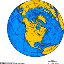
Global view centered on North America

North America is the third largest continent, and is also a portion of the third largest supercontinent if North and South America are combined into the Americas and Africa, Europe, and Asia are considered to be part of one supercontinent called Afro-Eurasia. With an estimated population of 580 million and an area of 24,709,000 km2 (9,540,000 mi2), the northernmost of the two continents of the Western Hemisphere is bounded by the Pacific Ocean on the west; the Atlantic Ocean on the east; the Caribbean Sea on the south; and the Arctic Ocean on the north.

The northern half of North America is sparsely populated and covered mostly by Canada, except for the northeastern portion, which is occupied by Greenland, and the northwestern portion, which is occupied by Alaska, the largest state of the United States. The central and southern portions of the continent are occupied by the contiguous United States, Mexico, and numerous smaller states in Central America and in the Caribbean.

The continent is delimited on the southeast by most geographers at the Darién watershed along the Colombia-Panama border, placing all of Panama within North America. Alternatively, a less common view would end North America at the man-made Panama Canal. Islands generally associated with North America include Greenland, the world's largest island, and archipelagos and islands in the Caribbean. The terminology of the Americas is complex, but "Anglo-America" can describe Canada and the U.S., while "Latin America" comprises Mexico and the countries of Central America and the Caribbean, as well as the entire continent of South America.

Natural features of North America include the northern portion of the American Cordillera, represented by the geologically new Rocky Mountains in the west; and the considerably older Appalachian Mountains to the east. The north hosts an abundance of glacial lakes formed during the last glacial period, including the Great Lakes. North America's major continental divide is the Great Divide, which runs north and south down through Rocky Mountains. The major watersheds draining to the include the Mississippi/Missouri and Rio Grande draining into the Gulf of Mexico (part of the Atlantic Ocean), and the St. Lawrence draining into the Atlantic. The Colorado, Colombia, and Yukon Rivers drain west to the Pacific Ocean.

Climate is determined to a large extent by the latitude, ranging from Arctic cold in the north to tropical heat in the south. There are steppes (known as "prairies") in the central and western portions, and deserts in the Southwestern United States of Arizona, Colorado, California, Nevada, New Mexico, Utah, and Texas; along with the Mexican states of Baja California, Baja California Sur, Sonora, Chihuahua, Coahuila, Nuevo Leon and Tamaulipas.
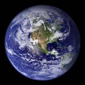
The Blue Marble, NASA; east more rain than west.

Paleogeography

The paleogeological origins of the basement rocks underlying North America.
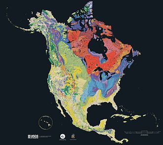
Age of the bedrock underlying North America, from red (oldest) to blue, green, yellow (newest).

Seventy percent of North America is underlain by the Laurentia craton, which is exposed as the Canadian Shield in much of central and eastern Canada around the Hudson Bay, and as far south as the U.S. states of Michigan, Wisconsin, and Minnesota. The continental crust started to form 4 billion years ago (Ga), and six of the microcontinents collided to form the craton about 2 Ga. This core has been enlarged by plate tectonics, most notably between 1.8 and 1.65 Ga when a piece currently stretching from Arizona to Missouri fused with the south and west portion of the craton. The craton started to rift about 1.1 Ga, and the fissure (now the Midcontinent Rift System) ran between Kansas and Lake Superior before stopping, perhaps due to the Grenville collision in the east. Otherwise the craton has remained relatively stable, with some rocks dating from 2.5 to 4 Ga, including what may be the world's oldest known rock: Specimens from the Nuvvuagittuq greenstone belt on the coast of the Hudson Bay have been dated to 4.38 Ga, though the dating methods are disputed. Periodic flooding by inland seas, most recently the Western Interior Seaway during the Cretaceous, caused the layer of sedimentary rock over the remainder of the craton. The Laurentia craton is the center of the Proterozoic supercontinent Rodinia in most models, and was also part of the later Laurussia, Pangea, and Laurasia supercontinents.

Roughly 3 million years ago (Ma), the volcanic Isthmus of Panama formed between the North and South American continents creating a bridge over what was the Central American Seaway and allowing the migration of flora and fauna between the two landmasses in the Great American Interchange. Starting 2.58 Ma, the Quaternary glaciation covered much of the continent with ice, centered west of Hudson Bay, the floor of which is slowly rebounding after being depressed by the great weight of the ice. Glaciers descended the slopes of the Rocky Mountains and those of the Pacific Margin. Extensive glacial lakes, such as Glacial Lake Missoula, Bonneville, Lahontan, Agassiz, and Algonquin, formed by glacial melt water. "Remnants of them are still visible in the Great Basin and along the edge of the Canadian Shield in the form of the Great Salt Lake, the Great Lakes, and the large lakes of west central Canada." The last glacial period of the current ice age caused a lowering of the sea level, exposing the Bering Land Bridge between Alaska and Siberia, which resulted in human migration from Asia to the Americas between 40,000 and 15,000 years ago.

North America can also be divided into four great regions:

  • Great Plains: stretching from the Gulf of Mexico to the Canadian Arctic;
  • the geologically young, mountainous west: including the Rocky Mountains, the Great Basin, California and Alaska;
  • the raised but relatively flat plateau of the Canadian Shield in the northeast;
  • the varied eastern region: including the Appalachian Mountains, the coastal plain of the Atlantic Seaboard, and the Florida peninsula.

Mexico and its long plateaus and cordilleras fall largely in the western region, although the eastern coastal plain does extend south along the Gulf.

  North American Plate (center top)
  Caribbean Plate (center)

Physiography

North America may be divided into at least five major physiographic regions:

Canadian Shield
This is a geologically stable area of rock dating between 2.5 and 4 Gya that occupies most of the northeastern quadrant, including Greenland.
Appalachian Mountains
The Appalachians are an old and eroded system that formed about 300 Ma and extends from the Gaspé Peninsula to Alabama.
Atlantic Coastal Plain
The plain is a belt of lowlands widening to the south that extends from south New England to Mexico.
Interior Lowlands
The lowlands extend down the middle of the continent from the Mackenzie Valley to the Atlantic Coastal Plain, and include the Great Plains on the west and the agriculturally productive Interior Plains on the east.
North American Cordillera
The cordillera is a complex belt of mountains and associated plateaus and basins some of which were formed as recently as 100–65 Ma, during the Cretaceous. The cordillera extend from Alaska into Mexico and includes two orogenic belts — the Pacific Margin on the west and the Rocky Mountains on the east — separated by a system of intermontane plateaus and basins.

The Coastal Plain and the main belts of the North American Cordillera continue in the south in Mexico (where the Mexican Plateau, bordered by the Sierra Madre Oriental and the Sierra Madre Occidental, is considered a continuation of the intermontane system) to connect the Transverse Volcanic Range, a zone of high and active volcanic peaks south of Mexico City.

The vast majority of North America is located on the North American Plate, centered on the Laurentia craton. Parts of California and western Mexico form the partial edge of the Pacific Plate; the two plates meet along the San Andreas Fault. The southern portion of the Caribbean and parts of Central America compose the much smaller Caribbean Plate.

The western mountains have split in the middle, into the main range of the Rockies and the Coast Ranges in California, Oregon, Washington, and British Columbia with the Great Basin (a lower area containing smaller ranges and low-lying deserts) in between. The highest peak is Mount McKinley/Denali in Alaska.

Three countries (Canada, the United States, and Mexico) make up most of North America's land mass; they share the continent with 34 other island countries in the Caribbean and south of Mexico.

Geographic center of North America

The geographic center of North America is near Center, North Dakota, according to Peter Rogerson, geography professor at the University at Buffalo, who published a new method of calculating geographical centers.

Earlier placements in 1931 involved geographers balancing a cardboard cutout of a region on a needlelike point to find its center to establish a spot "6 miles west of Balta, Pierce County, North Dakota", at 48⁰ 10′north, 100⁰ 10′west. In 1932, a field stone cairn recognizing this was erected in nearby Rugby, North Dakota at the intersections of U.S. Route 2 and ND State Highway 3.

Surface and climate

Landforms and land cover of North America
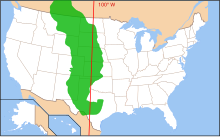
The Great Plains

The Great Plains is the broad expanse of prairie and steppe which lies east of the Rocky Mountains in the United States and Canada. The narrow plains in the Mexican coast and the savannas of the Mississippi are analogous to, respectively, the Patagonian Steppes and the pampas of the Piranha, Paraguay, and Rio de la Plata. Thus the Appalachians and the mountain chains of Brazil are regarded as creating similar interruptions to the plains community.

North America extends to within 10° of latitude of both the equator and the North Pole. It embraces every climatic zone, from tropical rain forest and savanna on the lowlands of Central America to areas of permanent ice cap in central Greenland. Subarctic and tundra climates prevail in north Canada and north Alaska, and desert and semiarid conditions are found in interior regions cut off by high mountains from rain-bearing westerly winds. However, most of the continent has temperate climates very favorable to settlement and agriculture. Prairies, or vast grasslands cover a huge amount in mountain ranges.

North America's greatest snowfalls

Greatest Snowfalls

Places Date Inches Centimeters
24 hours Silver Lake, Colorado April 14–15, 1921 76 195.6
1 month Tamarack, California January 1911 390 991
One storm Mt. Shasta Ski Bowl, Calif. February 13–19, 1959 189 480
One season Mount Baker, WA 1998–1999 1, 140 2, 895.6

Hydrography and deserts

The average rainfall in North America is 76 cm/year, which produces some 18 petaliters of water.

River systems

North American Watersheds (Atlantic, Arctic, Great Basin, & Pacific)
Saint Lawrence River on the New York–Ontario border
The Upper Rio Grande by Creede, Colorado
The Columbia River from Canada to the Pacific

Listed below by watershed are some of the more notable rivers in North America. Rivers flow entirely within the United States, unless otherwise noted.

North America map of Köppen climate classification.

Climate and vegetation

There are various plant life distributions in North America. Plant life in the Arctic includes grasses, mosses, and Arctic willows. Coniferous trees, including spruces, pines, hemlocks, and firs, are indigenous to the Canadian and Western U.S. mountain ranges as far south as San Francisco. Among these are giant sequoias, redwoods, great firs, and sugar pines. Sugar pines are generally confined to the northwestern area of the United States. The central region of the country has hardwoods. Southern states grow extensive yellow pines. In addition, mahogany, logwood, and lignumvitae - all tropical in nature - are grown. The southwest has desert plants, including yucca and cacti. The cultivated native plants of North America are tobacco, maize, vanilla, melons, cacao, gourds, indigo plant, and beans.

Deserts

The Sierra Nevada and Cascade mountain ranges run along the entire Pacific Coast, acting as a barrier to the humid winds that sweep in from the ocean. The rising topography forces this air upwards, causing moisture to condense and fall in the form of rain on the western slopes of the mountains, with some areas receiving more than 70 inches (1.8 m) of rainfall per year. As a result, the air has lost much of its moisture and becomes hot and dry when it reaches the areas east of the coastal mountain ranges. These arid conditions are, in some instances, exacerbated in regions of extremely low altitude (some near or below sea level) by higher air pressure, resulting in drier conditions and adiabatic heating effects, some of these pocket deserts exist in valleys well north of the Canada–US border in interior British Columbia. What precipitation does fall generally does not last long, lost primarily to evaporation, as well as rapid runoff and efficient water uptake and storage by native vegetation.

Major habitat types of the United States and Canada Ecoregions map of Canada, United States and Mexico

Zoology

North America is home to many native mammal species. Several species of deer, including elk, caribou, moose, mule deer, and the abundant white-tailed deer are found throughout various regions, along with the bison in the central plains and the and musk ox in the Arctic tundra. Three species of bear, several subspecies of wolf, and various other carnivores such as raccoons, skunks, and cats including cougars and lynxes are widely distributed. The family Mustelidae is well represented, including badgers, otters, ferrets, and wolverines. Numerous species of squirrels and other rodents, such as beavers and muskrats, can be found in virtually every region of the continent. Central America has adapted sloths, anteaters, and armadillos. Other animals includes the California condor, mostly found in California, the parrots and the monkeys of Tropical forests, the humming bird, rattlesnake, alligator, and Cayman of the banks of the streams, and swarms of mosquitoes on the wide plains.

Mining and petroleum

Picture of Rocky Mountains

The mining and petroleum industries are important in Canada, the United States and Mexico. These natural resources make the region one of the richest on the earth.

Rocky Mountains

The Rocky Mountain region is known for vast resources and rich mineral deposits including copper, lead, gold, silver, tungsten or Wolfram, uranium, zinc and Coal, petroleum and natural gas are mineral fuels found. Old mine tailings are present in the Rocky Mountain landscape.

Agriculture and forestry

Agriculture and forestry are two major industries. Agriculture includes arid land and irrigated farming and livestock grazing. Livestock are often moved between high-elevation summer pastures and low-elevation and winter pastures.

Ocean color

From Wikipedia, the free encyclopedia
 
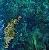
Deep blue water, blue-green water, satellite image of the Bahamas where sunlight reflects off sand and reefs in the shallows, satellite image of phytoplankton bloom in the Southern Ocean, satellite image of the Pribilof Islands showing shades of color from different phytoplankton, and satellite image of the Baltic Sea with phytoplankton blooms.

Ocean color is the branch of ocean optics that specifically studies the color of the water and information that can be gained from looking at variations in color. The color of the ocean, while mainly blue, actually varies from blue to green or even yellow, brown or red in some cases. This field of study developed alongside water remote sensing, so it is focused mainly on how color is measured by instruments (like the sensors on satellites and airplanes).

Most of the ocean is blue in color, but in some places the ocean is blue-green, green, or even yellow to brown. Blue ocean color is a result of several factors. First, water preferentially absorbs red light, which means that blue light remains and is reflected back out of the water. Red light is most easily absorbed and thus does not reach great depths, usually to less than 50 meters (164 ft). Blue light, in comparison, can penetrate up to 200 meters (656 ft). Second, water molecules and very tiny particles in ocean water preferentially scatter blue light more than light of other colors. Blue light scattering by water and tiny particles happens even in the very clearest ocean water, and is similar to blue light scattering in the sky.

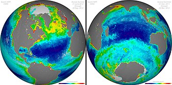
The main substances that affect the color of the ocean include dissolved organic matter, living phytoplankton with chlorophyll pigments, and non-living particles like marine snow and mineral sediments. Chlorophyll can be measured by satellite observations and serves as a proxy for ocean productivity (marine primary productivity) in surface waters. In long term composite satellite images, regions with high ocean productivity show up in yellow and green colors because they contain more (green) phytoplankton, whereas areas of low productivity show up in blue.

Overview

Ocean color depends on how light interacts with the materials in the water. When light enters water, it can either be absorbed (light gets used up, the water gets "darker"), scattered (light gets bounced around in different directions, the water remains "bright"), or a combination of both. How underwater absorption and scattering vary spectrally, or across the spectrum of visible to infrared light energy (about 400 nm to 2000 nm wavelengths) determines what "color" the water will appear to a sensor.

Water types by color

Most of the world’s oceans appear blue because the light leaving water is brightest (has the highest reflectance value) in the blue part of the visible light spectrum. Nearer to land, coastal waters often appear green. Green waters appear this way because algae and dissolved substances are absorbing light in the blue and red portions of the spectrum.

Blue oceans

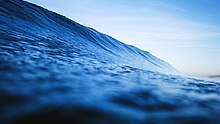
A deep blue colored wave viewed from the water surface near Encinitas, California, United States. The Pacific Ocean contains some of the most deep blue colored waters in the world.

The reason that open-ocean waters appear blue is that they are very clear, somewhat similar to pure water, and have few materials present or very tiny particles only. Pure water absorbs red light with depth. As red light is absorbed, blue light remains. Large quantities of pure water appear blue (even in a white-bottom swimming pool or white-painted bucket). The substances that are present in blue-colored open ocean waters are often very tiny particles which scatter light, scattering light especially strongly in the blue wavelengths. Light scattering in blue water is similar to the scattering in the atmosphere which makes the sky appear blue (called Rayleigh scattering). Some blue-colored clear water lakes appear blue for these same reasons, like Lake Tahoe in the United States.

Green oceans

Microscopic marine algae, called phytoplankton, absorb light in the blue and red wavelengths, due to their specific pigments like chlorophyll-a. Accordingly, with more and more phytoplankton in the water, the color of the water shifts toward the green part of the spectrum.

The most widespread light-absorbing substance in the oceans is chlorophyll pigment, which phytoplankton use to produce carbon by photosynthesis. Chlorophyll, a green pigment, makes phytoplankton preferentially absorb the red and blue portions of the light spectrum . As blue and red light are absorbed, green light remains. Ocean regions with high concentrations of phytoplankton have shades of blue-to-green water depending on the amount and type of the phytoplankton.

Green waters can also have a combination of phytoplankton, dissolved substances, and sediments, while still appearing green. This often happens in estuaries, coastal waters, and inland waters, which are called "optically complex" waters because multiple different substances are creating the green color seen by the sensor.


A surfer cuts through a green colored wave of ocean water at Strandhill, Ireland.

Yellow to brown oceans

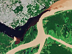
Sentinel-2 satellite image of the confluence of the Rio Negro and the Solimões River, Brazil. The Rio Negro in the upper left part of the image is dark due to high concentrations of colored dissolved organic matter (CDOM). The Solimões River in the lower and right part of the image is brighter because of large amounts of sediments.

Ocean water appears yellow or brown when large amounts of dissolved substances, sediments, or both types of material are present.

Water can appear yellow or brown due to large amounts of dissolved substances. Dissolved matter or gelbstoff (meaning yellow substance) appears dark yet relatively transparent, much like tea. Dissolved substances absorb blue light more strongly than light of other colors. Colored dissolved organic matter (CDOM) often comes from decaying plant matter on land or in marshes, or in the open ocean from marine phytoplankton exuding dissolved substances from their cells.

In coastal areas, runoff from rivers and resuspension of sand and silt from the bottom add sediments to surface waters. More sediments can make the waters appear more green, yellow, or brown because sediment particles scatter light energy at all colors. In large amounts, mineral particles like sediment cause the water to turn brownish if there is a massive sediment loading event, appearing bright and opaque (not transparent), much like chocolate milk.

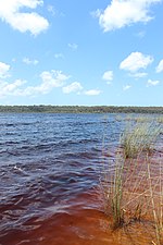
In Lake Boomanjin, Australia, the waters are strongly colored due to tannins from nearby trees.
MODIS satellite image of the Mississippi River sediment plume in the Gulf of Mexico following a series of rainstorms in February 2018 (image from March 4, 2018).

Red oceans

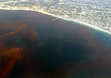
Red tide off the Scripps Institution of Oceanography Pier, La Jolla, California, United States.

Ocean water can appear red if there is a bloom of a specific kind of phytoplankton causing a discoloration of the sea surface. These events are called "Red tides." However, not all red tides are harmful, and they are only considered harmful algal blooms if the type of plankton involved contains hazardous toxins. The red color comes from the pigments in the specific kinds of phytoplankton causing the bloom. Some examples are Karenia brevis in the Gulf of Mexico, Alexandrium fundyense in the Gulf of Maine, Margalefadinium polykroides and Alexandrium monilatum in the Chesapeake Bay, and Mesodinium rubrum in Long Island Sound.

Ocean color remote sensing

Ocean color remote sensing is also referred to as ocean color radiometry. Remote sensors on satellites, airplanes, and drones measure the spectrum of light energy coming from the water surface. The sensors used to measure light energy coming from the water are called radiometers (or spectrometers or spectroradiometers). Some radiometers are used in the field at earth’s surface on ships or directly in the water. Other radiometers are designed specifically for airplanes or earth-orbiting satellite missions. Using radiometers, scientists measure the amount of light energy coming from the water at all colors of the electromagnetic spectrum from ultraviolet to near-infrared. From this reflected spectrum of light energy, or the apparent "color," researchers derive other variables to understand the physics and biology of the oceans.

Ocean color measurements can be used to infer important information such as phytoplankton biomass or concentrations of other living and non-living material. The patterns of algal blooms from satellite over time, over large regions up to the scale of the global ocean, has been instrumental in characterizing variability of marine ecosystems. Ocean color data is a key tool for research into how marine ecosystems respond to climate change and anthropogenic perturbations.

One of the biggest challenges for ocean color remote sensing is atmospheric correction, or removing the color signal of the atmospheric haze and clouds to focus on the color signal of the ocean water. The signal from the water itself is less than 10% of the total signal of light leaving earth’s surface.

History

Scientists including biologist Ellen Weaver helped to develop the first sensors to measure ocean productivity from above, beginning with airplane-mounted sensors.

People have written about the color of the ocean over many centuries, including ancient Greek poet Homer’s famous "wine-dark sea." Scientific measurements of the color of the ocean date back to the invention of the Secchi disk in Italy in the mid-1800s to study the transparency and clarity of the sea.

Major accomplishments were made in the 1960s and 1970s leading up to modern ocean color remote sensing campaigns. Nils Gunnar Jerlov’s book Optical Oceanography, published in 1968, was a starting point for many researchers in the next decades. In 1970, George Clarke published the first evidence that chlorophyll concentration could be estimated based on green versus blue light coming from the water, as measured from an airplane over George's Bank. In the 1970s, scientist Howard Gordon and his graduate student George Maul related imagery from the first Landsat mission to ocean color. Around the same time, a group of researchers, including John Arvesen, Dr. Ellen Weaver, and explorer Jacques Cousteau, began developing sensors to measure ocean productivity beginning with an airborne sensor.

Remote sensing of ocean color from space began in 1978 with the successful launch of NASA's Coastal Zone Color Scanner (CZCS) on the Nimbus-7 satellite. Despite the fact that CZCS was an experimental mission intended to last only one year as a proof of concept, the sensor continued to generate a valuable time-series of data over selected test sites until early 1986. Ten years passed before other sources of ocean color data became available with the launch of other sensors, and in particular the Sea-viewing Wide Field-of-view sensor (SeaWiFS) in 1997 on board the NASA SeaStar satellite. Subsequent sensors have included NASA's Moderate-resolution Imaging Spectroradiometer (MODIS) on board the Aqua and Terra satellites, ESA's MEdium Resolution Imaging Spectrometer (MERIS) onboard its environmental satellite Envisat. Several new ocean-colour sensors have recently been launched, including the Indian Ocean Colour Monitor (OCM-2) on-board ISRO's Oceansat-2 satellite and the Korean Geostationary Ocean Color Imager (GOCI), which is the first ocean colour sensor to be launched on a geostationary satellite, and Visible Infrared Imager Radiometer Suite (VIIRS) aboard NASA's Suomi NPP . More ocean colour sensors are planned over the next decade by various space agencies, including hyperspectral imaging.

Applications

Ocean Color Radiometry and its derived products are also seen as fundamental Essential Climate Variables as defined by the Global Climate Observing System. Ocean color datasets provide the only global synoptic perspective of primary production in the oceans, giving insight into the role of the world's oceans in the global carbon cycle. Ocean color data helps researchers map information relevant to society, such as water quality, hazards to human health like harmful algal blooms, bathymetry, and primary production and habitat types affecting commercially-important fisheries.

Chlorophyll as a proxy for phytoplankton

Season-long composites of ocean chlorophyll concentrations. The purple and blue colors represent lower chlorophyll concentrations. The oranges and reds represent higher chlorophyll concentrations. These differences indicate areas with lesser or greater phytoplankton biomass.

The most widely used piece of information from ocean color remote sensing is satellite-derived chlorophyll-a concentration. Researchers calculate satellite-derived chlorophyll-a concentration from space based on the central premise that the more phytoplankton is in the water, the greener it is.

Phytoplankton are microscopic algae, marine primary producers that turn sunlight into chemical energy that supports the ocean food web. Like plants on land, phytoplankton create oxygen for other life on earth. Ocean color remote sensing ever since the launch of SeaWiFS in 1997 has allowed scientists to map phytoplankton – and thus model primary production - throughout the world’s oceans over many decades, marking a major advance in our knowledge of the earth system.

Other applications

Suspended sediments can be seen in satellite imagery following events when high winds cause waves to stir up the seafloor, like in this image of the western side of the Yucatan Peninsula. Darker brown colored water shows where sediments come from land via rivers, while lighter colored water shows where sediments come from the chalky calcium carbonate sands on the seafloor.

Beyond chlorophyll, a few examples of some of the ways that ocean color data are used include:

Harmful algal blooms

Researchers use ocean color data in conjunction with meteorological data and field sampling to forecast the development and movement of harmful algal blooms (commonly referred to as "red tides," although the two terms are not exactly the same). For example, MODIS data has been used to map Karenia brevis blooms in the Gulf of Mexico.

Suspended sediments

Researchers use ocean color data to map the extent of river plumes and document wind-driven resuspension of sediments from the seafloor. For example, after hurricanes Katrina and Rita in the Gulf of Mexico, ocean color remote sensing was used to map the effects offshore.

Sensors

Sensors used to measure ocean color are instruments that measure light at multiple wavelengths (multispectral) or a continuous spectrum of colors (hyperspectral), usually spectroradiometers or optical radiometers. Ocean color sensors can either be mounted on satellites or airplanes, or used at earth’s surface.

Satellite sensors

The sensors below are earth-orbiting satellite sensors. The same sensor can be mounted on multiple satellites to give more coverage over time (aka higher temporal resolution). For example, the MODIS sensor is mounted on both Aqua and Terra satellites. Additionally, the VIIRS sensor is mounted on both Suomi National Polar-Orbiting Partnership (Suomi-NPP or SNPP) and Joint Polar Satellite System (JPSS-1, now known as NOAA-20) satellites.

  • Coastal Zone Color Scanner (CZCS)
  • Sea-viewing Wide Field-of-view Sensor (SeaWiFS) on OrbView-2 (aka SeaStar)
  • Moderate-resolution Imaging Spectroradiometer (MODIS) on Aqua and Terra satellites
  • Medium Resolution Imaging Spectrometer (MERIS)
  • Polarization and Directionality of the Earth's Reflectances (POLDER)
  • Geostationary Ocean Color Imager(GOCI) on the Communication, Ocean, and Meteorological (COMS) satellite
  • Ocean Color Monitor (OCM) on Oceansat-2
  • Ocean Color and Temperature Scanner (OCTS) on the Advanced Earth Observing Satellite (ADEOS)
  • Multi Spectral Instrument (MSI) on Sentinel-2A and Sentinel-2B
  • Ocean and Land Colour Instrument (OLCI) on Sentinel-3A and Sentinel-3B
  • Visible Infrared Imaging Radiometer Suite (VIIRS) on Suomi-NPP (SNPP) and NOAA-20 (JPSS1) satellites
  • Operational Land Imager (OLI) on Landsat-8
  • Hyperspectral Imager for the Coastal Ocean (HICO) on the International Space Station
  • Precursore IperSpettrale della Missione Applicative (PRISMA)
  • Hawkeye on the SeaHawk Cubesat
  • Ocean color instrument (OCI) and 2 polarimeters on the planned Plankton, Aerosol, Cloud, ocean Ecosystem satellite

Airborne sensors

The following sensors were designed to measure ocean color from airplanes for airborne remote sensing:

  • Airborne Visible/Infrared Imaging Spectrometer (AVIRIS)
  • Airborne Ocean Color Imager (AOCI)
  • Portable Remote Imaging Spectrometer (PRISM) flown for the CORALS project on the Tempus Applied Solutions Gulfstream-IV (G-IV) aircraft
  • Headwall Hyperspectral Imaging System (HIS)
  • Coastal Airborne In situ Radiometers (C-AIR) bio-optical radiometer package 
  • Compact Airborne Spectrographic Imager (CASI)

In situ sensors

A researcher uses a spectroradiometer to measure the light energy radiating from an ice melt pond in the Chukchi Sea in summer 2011.

At earth’s surface, such as on research vessels, in the water using buoys, or on piers and towers, ocean color sensors take measurements that are then used to calibrate and validate satellite sensor data. Calibration and validation are two types of "ground-truthing" that are done independently. Calibration is the tuning of raw data from the sensor to match known values, such as the brightness of the moon or a known reflection value at earth’s surface. Calibration, done throughout the lifetime of any sensor, is especially critical to the early part of any satellite mission when the sensor is developed, launched, and beginning its first raw data collection. Validation is the independent comparison of measurements made in situ with measurements made from a satellite or airborne sensor. Satellite calibration and validation maintain the quality of ocean color satellite data. There are many kinds of in situ sensors, and the different types are often compared on dedicated field campaigns or lab experiments called "round robins." In situ data are archived in data libraries such as the SeaBASS data archive. Some examples of in situ sensors (or networks of many sensors) used to calibrate or validate satellite data are:

  • Marine Optical Buoy (MOBY)
  • Aerosol Robotic Network (AERONET)
  • PANTHYR instrument
  • Trios-RAMSES
  • Compact Optical Profiling System (C-OPS)
  • HyperSAS and HyperPro instruments

Lunar theory

From Wikipedia, the free encyclopedia

Lunar theory attempts to account for the motions of the Moon. There are many small variations (or perturbations) in the Moon's motion, and many attempts have been made to account for them. After centuries of being problematic, lunar motion can now be modeled to a very high degree of accuracy (see section Modern developments).

Lunar theory includes:

  • the background of general theory; including mathematical techniques used to analyze the Moon's motion and to generate formulae and algorithms for predicting its movements; and also
  • quantitative formulae, algorithms, and geometrical diagrams that may be used to compute the Moon's position for a given time; often by the help of tables based on the algorithms.

Lunar theory has a history of over 2000 years of investigation. Its more modern developments have been used over the last three centuries for fundamental scientific and technological purposes, and are still being used in that way.

Applications

Applications of lunar theory have included the following:

History

The Moon has been observed for millennia. Over these ages, various levels of care and precision have been possible, according to the techniques of observation available at any time. There is a correspondingly long history of lunar theories: it stretches from the times of the Babylonian and Greek astronomers, down to modern lunar laser ranging.

Among notable astronomers and mathematicians down the ages, whose names are associated with lunar theories, are:

Babylonian/Chaldean

Greek/Hellenistic

Arab

European, 16th to early 20th centuries

North American, 19th to early 20th centuries

Other notable mathematicians and mathematical astronomers also made significant contributions.

The history can be considered to fall into three parts: from ancient times to Newton; the period of classical (Newtonian) physics; and modern developments.

Ancient times to Newton

Babylon

Of Babylonian astronomy, practically nothing was known to historians of science before the 1880s. Surviving ancient writings of Pliny had made bare mention of three astronomical schools in Mesopotamia – at Babylon, Uruk, and 'Hipparenum' (possibly 'Sippar'). But definite modern knowledge of any details only began when Joseph Epping deciphered cuneiform texts on clay tablets from a Babylonian archive: In these texts he identified an ephemeris of positions of the Moon. Since then, knowledge of the subject, still fragmentary, has had to be built up by painstaking analysis of deciphered texts, mainly in numerical form, on tablets from Babylon and Uruk (no trace has yet been found of anything from the third school mentioned by Pliny).

To the Babylonian astronomer Kidinnu (in Greek or Latin, Kidenas or Cidenas) has been attributed the invention (5th or 4th century BC) of what is now called "System  B" for predicting the position of the moon, taking account that the moon continually changes its speed along its path relative to the background of fixed stars. This system involved calculating daily stepwise changes of lunar speed, up or down, with a minimum and a maximum approximately each month. The basis of these systems appears to have been arithmetical rather than geometrical, but they did approximately account for the main lunar inequality now known as the equation of the center.

The Babylonians kept very accurate records for hundreds of years of new moons and eclipses. Some time between the years 500 BC and 400 BC they identified and began to use the 19 year cyclic relation between lunar months and solar years now known as the Metonic cycle.

This helped them build a numerical theory of the main irregularities in the Moon's motion, reaching remarkably good estimates for the (different) periods of the three most prominent features of the Moon's motion:

  • The synodic month, i.e. the mean period for the phases of the Moon. Now called "System B", it reckons the synodic month as 29 days and (sexagesimally) 3,11;0,50 "time degrees", where each time degree is one degree of the apparent motion of the stars, or 4 minutes of time, and the sexagesimal values after the semicolon are fractions of a time degree. This converts to 29.530594 days = 29d 12h 44m 3.33s, to compare with a modern value (as at 1900 Jan 0) of 29.530589 days, or 29d 12h 44m 2.9s. This same value was used by Hipparchos and Ptolemy, was used throughout the Middle Ages, and still forms the basis of the Hebrew calendar.
  • The mean lunar velocity relative to the stars they estimated at 13° 10′ 35″ per day, giving a corresponding month of 27.321598 days, to compare with modern values of 13° 10′ 35.0275″ and 27.321582 days.
  • The anomalistic month, i.e. the mean period for the Moon's approximately monthly accelerations and decelerations in its rate of movement against the stars, had a Babylonian estimate of 27.5545833 days, to compare with a modern value 27.554551 days.
  • The draconitic month, i.e. the mean period with which the path of the Moon against the stars deviates first north and then south in ecliptic latitude by comparison with the ecliptic path of the Sun, was indicated by a number of different parameters leading to various estimates, e.g. of 27.212204 days, to compare with a modern value of 27.212221, but the Babylonians also had a numerical relationship that 5458 synodic months were equal to 5923 draconitic months, which when compared with their accurate value for the synodic month leads to practically exactly the modern figure for the draconitic month.

The Babylonian estimate for the synodic month was adopted for the greater part of two millennia by Hipparchus, Ptolemy, and medieval writers (and it is still in use as part of the basis for the calculated Hebrew (Jewish) calendar).

Greece and Hellenistic Egypt

Thereafter, from Hipparchus and Ptolemy in the Bithynian and Ptolemaic epochs down to the time of Newton's work in the seventeenth century, lunar theories were composed mainly with the help of geometrical ideas, inspired more or less directly by long series of positional observations of the moon. Prominent in these geometrical lunar theories were combinations of circular motions – applications of the theory of epicycles.

Hipparchus

Hipparchus, whose works are mostly lost and known mainly from quotations by other authors, assumed that the Moon moved in a circle inclined at 5° to the ecliptic, rotating in a retrograde direction (i.e. opposite to the direction of annual and monthly apparent movements of the Sun and Moon relative to the fixed stars) once in 1823 years. The circle acted as a deferent, carrying an epicycle along which the Moon was assumed to move in a retrograde direction. The center of the epicycle moved at a rate corresponding to the mean change in Moon's longitude, while the period of the Moon around the epicycle was an anomalistic month. This epicycle approximately provided for what was later recognized as the elliptical inequality, the equation of the center, and its size approximated to an equation of the center of about 5° 1'. This figure is much smaller than the modern value: but it is close to the difference between the modern coefficients of the equation of the center (1st term) and that of the evection: the difference is accounted for by the fact that the ancient measurements were taken at times of eclipses, and the effect of the evection (which subtracts under those conditions from the equation of the center) was at that time unknown and overlooked. For further information see also separate article Evection.

Ptolemy

Ptolemy's work the Almagest had wide and long-lasting acceptance and influence for over a millennium. He gave a geometrical lunar theory that improved on that of Hipparchus by providing for a second inequality of the Moon's motion, using a device that made the apparent apogee oscillate a little – prosneusis of the epicycle. This second inequality or second anomaly accounted rather approximately, not only for the equation of the center, but also for what became known (much later) as the evection. But this theory, applied to its logical conclusion, would make the distance (and apparent diameter) of the Moon appear to vary by a factor of about 2, which is clearly not seen in reality. (The apparent angular diameter of the Moon does vary monthly, but only over a much narrower range of about 0.49°–0.55°.) This defect of the Ptolemaic theory led to proposed replacements by Ibn al-Shatir in the 14th century and by Copernicus in the 16th century.

Ibn al-Shatir and Copernicus

Significant advances in lunar theory were made by the Arab astronomer, Ibn al-Shatir (1304–1375). Drawing on the observation that the distance to the Moon did not change as drastically as required by Ptolemy's lunar model, he produced a new lunar model that replaced Ptolemy's crank mechanism with a double epicycle model that reduced the computed range of distances of the Moon from the Earth. A similar lunar theory, developed some 150 years later by the Renaissance astronomer Nicolaus Copernicus, had the same advantage concerning the lunar distances.

Tycho Brahe, Johannes Kepler, and Jeremiah Horrocks

Tycho Brahe and Johannes Kepler refined the Ptolemaic lunar theory, but did not overcome its central defect of giving a poor account of the (mainly monthly) variations in the Moon's distance, apparent diameter and parallax. Their work added to the lunar theory three substantial further discoveries.

  1. The nodes and the inclination of the lunar orbital plane both appear to librate, with a monthly (according to Tycho) or semi-annual period (according to Kepler).
  2. The lunar longitude has a twice-monthly Variation, by which the Moon moves faster than expected at new and full moon, and slower than expected at the quarters.
  3. There is also an annual effect, by which the lunar motion slows down a little in January and speeds up a little in July: the annual equation.

The refinements of Brahe and Kepler were recognized by their immediate successors as improvements, but their seventeenth-century successors tried numerous alternative geometrical configurations for the lunar motions to improve matters further. A notable success was achieved by Jeremiah Horrocks, who proposed a scheme involving an approximate 6 monthly libration in the position of the lunar apogee and also in the size of the elliptical eccentricity. This scheme had the great merit of giving a more realistic description of the changes in distance, diameter and parallax of the Moon.

Newton

A first gravitational period for lunar theory started with the work of Newton. He was the first to define the problem of the perturbed motion of the Moon in recognisably modern terms. His groundbreaking work is shown for example in the Principia in all versions including the first edition published in 1687.

Newton's biographer, David Brewster, reported that the complexity of Lunar Theory impacted Newton's health: "[H]e was deprived of his appetite and sleep" during his work on the problem in 1692-3, and told the astronomer John Machin that "his head never ached but when he was studying the subject". According to Brewster, Edmund Halley also told John Conduitt that when pressed to complete his analysis Newton "always replied that it made his head ache, and kept him awake so often, that he would think of it no more" [Emphasis in original].

Solar perturbation of lunar motion

Newton identified how to evaluate the perturbing effect on the relative motion of the Earth and Moon, arising from their gravity towards the Sun, in Book 1, Proposition 66, and in Book 3, Proposition 25. The starting-point for this approach is Corollary VI to the laws of motion. This shows that if the external accelerative forces from some massive body happens to act equally and in parallel on some different other bodies considered, then those bodies would be affected equally, and in that case their motions (relative to each other) would continue as if there were no such external accelerative forces at all. It is only in the case that the external forces (e.g. in Book 1, Prop. 66, and Book 3, Prop. 25, the gravitational attractions towards the Sun) are different in size or in direction in their accelerative effects on the different bodies considered (e.g. on the Earth and Moon), that consequent effects are appreciable on the relative motions of the latter bodies. (Newton referred to accelerative forces or accelerative gravity due to some external massive attractor such as the Sun. The measure he used was the acceleration that the force tends to produce (in modern terms, force per unit mass), rather than what we would now call the force itself.)

Thus Newton concluded that it is only the difference between the Sun's accelerative attraction on the Moon and the Sun's attraction on the Earth that perturbs the motion of the Moon relative to the Earth.

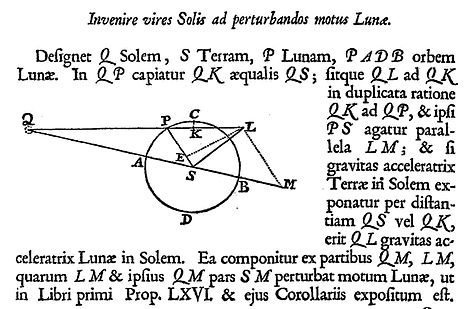
Newton then in effect used vector decomposition of forces, to carry out this analysis. In Book 1, Proposition 66 and in Book 3, Proposition 25, he showed by a geometrical construction, starting from the total gravitational attraction of the Sun on the Earth, and of the Sun on the Moon, the difference that represents the perturbing effect on the motion of the Moon relative to the Earth. In summary, line LS in Newton's diagram as shown below represents the size and direction of the perturbing acceleration acting on the Moon in the Moon's current position P (line LS does not pass through point P, but the text shows that this is not intended to be significant, it is a result of the scale factors and the way the diagram has been built up).

Newton's diagram 'to find the force of the Sun to perturb the Moon' accompanying Book 3, Proposition 25 of the Principia

Shown here is Newton's diagram from the first (1687) Latin edition of the Principia (Book 3, Proposition 25, p. 434). Here he introduced his analysis of perturbing accelerations on the Moon in the Sun-Earth-Moon system. Q represents the Sun, S the Earth, and P the Moon.

Parts of this diagram represent distances, other parts gravitational accelerations (attractive forces per unit mass). In a dual significance, SQ represents the Earth-Sun distance, and then it also represents the size and direction of the Earth-Sun gravitational acceleration. Other distances in the diagram are then in proportion to distance SQ. Other attractions are in proportion to attraction SQ.

The Sun's attractions are SQ (on the Earth) and LQ (on the Moon). The size of LQ is drawn so that the ratio of attractions LQ:SQ is the inverse square of the ratio of distances PQ:SQ. (Newton constructs KQ=SQ, giving an easier view of the proportions.) The Earth's attraction on the Moon acts along direction PS. (But line PS signifies only distance and direction so far, nothing has been defined about the scale factor between solar and terrestrial attractions).

After showing solar attractions LQ on the Moon and SQ on the Earth, on the same scale, Newton then makes a vector decomposition of LQ into components LM and MQ. Then he identifies the perturbing acceleration on the Moon as the difference of this from SQ. SQ and MQ are parallel to each other, so SQ can be directly subtracted from MQ, leaving MS. The resulting difference, after subtracting SQ from LQ, is therefore the vector sum of LM and MS: these add up to a perturbing acceleration LS.

Later Newton identified another resolution of the perturbing acceleration LM+MS = LS, into orthogonal components: a transverse component parallel to LE, and a radial component, effectively ES.

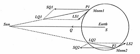
Alternative depiction of solar perturbations, vectors LS1 and LS2, like LS in Newton's diagram above, for 2 positions of the Moon P in its orbit around the Earth S

Newton's diagrammatic scheme, since his time, has been re-presented in other and perhaps visually clearer ways. Shown here is a vector presentation indicating, for two different positions, P1 and P2, of the Moon in its orbit around the Earth, the respective vectors LS1 and LS2 for the perturbing acceleration due to the Sun. The Moon's position at P1 is fairly close to what it was at P in Newton's diagram; corresponding perturbation LS1 is like Newton's LS in size and direction. At another position P2, the Moon is farther away from the Sun than the Earth is, the Sun's attraction LQ2 on the Moon is weaker than the Sun's attraction SQ=SQ2 on the Earth, and then the resulting perturbation LS2 points obliquely away from the Sun.

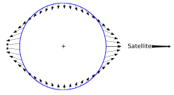
Solar perturbation vectors (arrows) analogous to LS at many positions of the Moon in its orbit around the Earth

Constructions like those in Newton's diagram can be repeated for many different positions of the Moon in its orbit. For each position, the result is a perturbation vector like LS1 or LS2 in the second diagram. Shown here is an often-presented form of the diagram that summarises sizes and directions of the perturbation vectors for many different positions of the Moon in its orbit. Each small arrow is a perturbation vector like LS, applicable to the Moon in the particular position around the orbit from which the arrow begins. The perturbations on the Moon when it is nearly in line along the Earth-Sun axis, i.e. near new or full moon, point outwards, away from the Earth. When the Moon-Earth line is 90° from the Earth-Sun axis they point inwards, towards the Earth, with a size that is only half the maximum size of the axial (outwards) perturbations. (Newton gave a rather good quantitative estimate for the size of the solar perturbing force: at quadrature where it adds to the Earth's attraction he put it at 1178.725 of the mean terrestrial attraction, and twice as much as that at the new and full moons where it opposes and diminishes the Earth's attraction.)

Newton also showed that the same pattern of perturbation applies, not only to the Moon, in its relation to the Earth as disturbed by the Sun, but also to other particles more generally in their relation to the solid Earth as disturbed by the Sun (or by the Moon); for example different portions of the tidal waters at the Earth's surface.[a] The study of the common pattern of these perturbing accelerations grew out of Newton's initial study of the perturbations of the Moon, which he also applied to the forces moving tidal waters. Nowadays this common pattern itself has become often known as a tidal force whether it is being applied to the disturbances of the motions of the Moon, or of the Earth's tidal waters – or of the motions of any other object that suffers perturbations of analogous pattern.

After introducing his diagram 'to find the force of the Sun to perturb the Moon' in Book 3, Proposition 25, Newton developed a first approximation to the solar perturbing force, showing in further detail how its components vary as the Moon follows its monthly path around the Earth. He also took the first steps in investigating how the perturbing force shows its effects by producing irregularities in the lunar motions.

For a selected few of the lunar inequalities, Newton showed in some quantitative detail how they arise from the solar perturbing force.

Much of this lunar work of Newton's was done in the 1680s, and the extent and accuracy of his first steps in the gravitational analysis was limited by several factors, including his own choice to develop and present the work in what was, on the whole, a difficult geometrical way, and by the limited accuracy and uncertainty of many astronomical measurements in his time.

Classical gravitational period after Newton

The main aim of Newton's successors, from Leonhard Euler, Alexis Clairaut and Jean d'Alembert in the mid-eighteenth century, down to Ernest William Brown in the late nineteenth and early twentieth century, was to account completely and much more precisely for the moon's motions on the basis of Newton's laws, i.e. the laws of motion and of universal gravitation by attractions inversely proportional to the squares of the distances between the attracting bodies. They also wished to put the inverse-square law of gravitation to the test, and for a time in the 1740s it was seriously doubted, on account of what was then thought to be a large discrepancy between the Newton-theoretical and the observed rates in the motion of the lunar apogee. However Clairaut showed shortly afterwards (1749–50) that at least the major cause of the discrepancy lay not in the lunar theory based on Newton's laws, but in excessive approximations that he and others had relied on to evaluate it.

Most of the improvements in theory after Newton were made in algebraic form: they involved voluminous and highly laborious amounts of infinitesimal calculus and trigonometry. It also remained necessary, for completing the theories of this period, to refer to observational measurements.

Results of the theories

The lunar theorists used (and invented) many different mathematical approaches to analyse the gravitational problem. Not surprisingly, their results tended to converge. From the time of the earliest gravitational analysts among Newton's successors, Euler, Clairaut and d'Alembert, it was recognized that nearly all of the main lunar perturbations could be expressed in terms of just a few angular arguments and coefficients. These can be represented by:

  • the mean motions or positions of the Moon and the Sun, together with three coefficients and three angular positions, which together define the shape and location of their apparent orbits:
  • the two eccentricities (, about 0.0549, and , about 0.01675) of the ellipses that approximate to the apparent orbits of the Moon and the Sun;
  • the angular direction of the perigees ( and ) (or their opposite points the apogees) of the two orbits; and
  • the angle of inclination (, mean value about 18523") between the planes of the two orbits, together with the direction () of the line of nodes in which those two planes intersect. The ascending node () is the node passed by the Moon when it is tending northwards relative to the ecliptic.

From these basic parameters, just four basic differential angular arguments are enough to express, in their different combinations, nearly all of the most significant perturbations of the lunar motions. They are given here with their conventional symbols due to Delaunay; they are sometimes known as the Delaunay arguments:

  • the Moon's mean anomaly (angular distance of the mean longitude of the Moon from the mean longitude of its perigee );
  • the Sun's mean anomaly (angular distance of the mean longitude of the Sun from the mean longitude of its perigee );
  • the Moon's mean argument of latitude (angular distance of the mean longitude of the Moon from the mean longitude of its ascending (northward-bound) node );
  • the Moon's mean (solar) elongation (angular distance of the mean longitude of the Moon from the mean longitude of the Sun).

This work culminated into Brown's lunar theory (1897–1908) and Tables of the Motion of the Moon (1919). These were used in the American Ephemeris and Nautical Almanac until 1968, and in a modified form until 1984.

Largest or named lunar inequalities

Several of the largest lunar perturbations in longitude (contributions to the difference in its true ecliptic longitude relative to its mean longitude) have been named. In terms of the differential arguments, they can be expressed in the following way, with coefficients rounded to the nearest second of arc ("):

Equation of the center

  • The Moon's equation of the center, or elliptic inequality, was known at least in approximation, to the ancients from the Babylonians and Hipparchus onwards. Knowledge of more recent date is that it corresponds to the approximate application of Kepler's law of equal areas in an elliptical orbit, and represents the speeding-up of the Moon as its distance from the Earth decreases while it moves towards its perigee, and then its slowing down as its distance from the Earth increases while it moves towards its apogee. The effect on the Moon's longitude can be approximated by a series of terms, of which the first three are .

Evection

  • The evection (or its approximation) was known to Ptolemy, but its name and knowledge of its cause dates from the 17th century. Its effect on the Moon's longitude has an odd-appearing period of about 31.8 days. This can be represented in a number of ways, for example as the result of an approximate 6-monthly libration in the position of perigee, with an accompanying 6-monthly pulsation in the size of the Moon's orbital eccentricity. Its principal term is .

Variation

  • The Variation, discovered by Tycho Brahe, is a speeding-up of the Moon as it approaches new-moon and full-moon, and a slowing-down as it approaches first and last quarter. Its gravitational explanation with a quantitative estimate was first given by Newton. Its principal term is .

Annual equation

  • The annual equation, also discovered by Brahe, was qualitatively explained by Newton in terms that the Moon's orbit becomes slightly expanded in size, and longer in period, when the Earth is at perihelion closest to the Sun at the beginning of January, and the Sun's perturbing effect is strongest, and then slightly contracted in size and shorter in period when the Sun is most distant in early July, so that its perturbing effect is weaker: the modern value for the principal term due to this effect is .

Parallactic inequality

  • The parallactic inequality, first found by Newton, makes Brahe's Variation a little asymmetric as a result of the finite distance and non-zero parallax of the Sun. Its effect is that the Moon is a little behind at first quarter, and a little ahead at last quarter. Its principal term is .

Reduction to the ecliptic

  • The reduction to the ecliptic represents the geometric effect of expressing the Moon's motion in terms of a longitude in the plane of the ecliptic, although its motion is really taking place in a plane that is inclined by about 5 degrees. Its principal term is .

The analysts of the mid-18th century expressed the perturbations of the Moon's position in longitude using about 25-30 trigonometrical terms. However, work in the nineteenth and twentieth century led to very different formulations of the theory so these terms are no longer current. The number of terms needed to express the Moon's position with the accuracy sought at the beginning of the twentieth century was over 1400; and the number of terms needed to emulate the accuracy of modern numerical integrations based on laser-ranging observations is in the tens of thousands: there is no limit to the increase in number of terms needed as requirements of accuracy increase.

Modern developments

Digital computers and lunar laser ranging

The Laser Ranging Facility at Goddard Spaceflight Center

Since the Second World War and especially since the 1960s, lunar theory has been further developed in a somewhat different way. This has been stimulated in two ways: on the one hand, by the use of automatic digital computation, and on the other hand, by modern observational data-types, with greatly increased accuracy and precision.

Wallace John Eckert, a student of Ernest William Brown and employee at IBM, used the experimental digital computers developed there after the Second World War for computation of astronomical ephemerides. One of the projects was to put Brown's lunar theory into the machine and evaluate the expressions directly. Another project was something entirely new: a numerical integration of the equations of motion for the Sun and the four major planets. This became feasible only after electronic digital computers became available. Eventually this led to the Jet Propulsion Laboratory Development Ephemeris series.

In the meantime, Brown's theory was improved with better constants and the introduction of Ephemeris Time and the removal of some empirical corrections associated with this. This led to the Improved Lunar Ephemeris (ILE), which, with some minor successive improvements, was used in the astronomical almanacs from 1960 through 1983 and enabled lunar landing missions.

The most significant improvement of position observations of the Moon have been the Lunar Laser Ranging measurements, obtained using Earth-bound lasers and special retroreflectors placed on the surface of the Moon. The time-of-flight of a pulse of laser light to one of the retroreflectors and back gives a measure of the Moon's distance at that time. The first of five retroreflectors that are operational today was taken to the Moon in the Apollo 11 spacecraft in July 1969 and placed in a suitable position on the Moon's surface by Buzz Aldrin. Range precision has been extended further by the Apache Point Observatory Lunar Laser-ranging Operation, established in 2005.

Numerical integrations, relativity, tides, librations

The lunar theory, as developed numerically to fine precision using these modern measures, is based on a larger range of considerations than the classical theories: It takes account not only of gravitational forces (with relativistic corrections) but also of many tidal and geophysical effects and a greatly extended theory of lunar libration. Like many other scientific fields this one has now developed so as to be based on the work of large teams and institutions. An institution notably taking one of the leading parts in these developments has been the Jet Propulsion Laboratory (JPL) at California Institute of Technology; and names particularly associated with the transition, from the early 1970s onwards, from classical lunar theories and ephemerides towards the modern state of the science include those of J. Derral Mulholland and J.G. Williams, and for the linked development of solar system (planetary) ephemerides E. Myles Standish.

Since the 1970s, JPL has produced a series of numerically integrated Development Ephemerides (numbered DExxx), incorporating Lunar Ephemerides (LExxx). Planetary and lunar ephemerides DE200/LE200 were used in the official Astronomical Almanac ephemerides for 1984–2002, and ephemerides DE405/LE405, of further improved accuracy and precision, have been in use as from the issue for 2003. The current ephemeris is DE440.

Analytical developments

In parallel with these developments, a new class of analytical lunar theory has also been developed in recent years, notably the Ephemeride Lunaire Parisienne by Jean Chapront and Michelle Chapront-Touzé from the Bureau des Longitudes. Using computer-assisted algebra, the analytical developments have been taken further than previously could be done by the classical analysts working manually. Also, some of these new analytical theories (like ELP) have been fitted to the numerical ephemerides previously developed at JPL as mentioned above. The main aims of these recent analytical theories, in contrast to the aims of the classical theories of past centuries, have not been to generate improved positional data for current dates; rather, their aims have included the study of further aspects of the motion, such as long-term properties, which may not so easily be apparent from the modern numerical theories themselves.

Politics of Europe

From Wikipedia, the free encyclopedia ...