Search This Blog

Friday, October 25, 2019

Tipping points in the climate system

From Wikipedia, the free encyclopedia
 
Possible tipping elements in the climate system.
 
A tipping point in the climate system is a threshold that, when exceeded, can lead to large changes in the state of the system. Potential tipping points have been identified in the physical climate system, in impacted ecosystems, and sometimes in both. For instance, feedback from the global carbon cycle is a driver for the transition between glacial and interglacial periods, with orbital forcing providing the initial trigger. Earth's geologic temperature record includes many more examples of geologically rapid transitions between different climate states.

Climate tipping points are of particular interest in reference to concerns about climate change in the modern era. Possible tipping point behaviour has been identified for the global mean surface temperature by studying self-reinforcing feedbacks and the past behavior of Earth's climate system. Self-reinforcing feedbacks in the carbon cycle and planetary reflectivity could trigger a cascading set of tipping points that lead the world into a hothouse climate state.

Large-scale components of the Earth system that may pass a tipping point have been referred to as tipping elements. Tipping elements are found in the Greenland and Antarctic ice sheets, possibly causing tens of meters of sea level rise. These tipping points are not always abrupt. For example, at some level of temperature rise the melt of a large part of the Greenland ice sheet and/or West Antarctic Ice Sheet will become inevitable; but the ice sheet itself may persist for many centuries. Some tipping elements, like the collapse of ecosystems, are irreversible.

Definition

The IPCC AR5 defines a tipping point as an irreversible change in the climate system. It states that the precise levels of climate change sufficient to trigger a tipping point remain uncertain, but that the risk associated with crossing multiple tipping points increases with rising temperature. A more broad definition of tipping points is sometimes used as well, which includes abrupt but reversible tipping points.

In mathematics tipping points have been characterised into three types dependent on the underlying mechanisms:
  • Bifurcation-induced tipping: System changes abruptly or qualitatively following a slow passage through a bifurcation (eg. Atlantic Meridional Overturning Circulation (AMOC) collapse)
  • Noise-induced tipping: Transitions due to random fluctuations/internal variability of the system (eg. Dansgaard-Oeschger events)
  • Rate-induced tipping: Failure to track a continuously (slowly) changing steady state (eg. Compost bomb instability)
In the context of climate change, an "adaptation tipping point" has been defined as "the threshold value or specific boundary condition where ecological, technical, economic, spatial or socially acceptable limits are exceeded."

Tipping points for global temperature

There are many positive and negative feedbacks to global temperatures and the carbon cycle that have been identified. The IPCC reports that feedbacks to increased temperatures are net positive for the remainder of this century, with the impact of cloud cover the largest uncertainty. IPCC carbon cycle models show higher ocean uptake of carbon corresponding to higher concentration pathways, but land carbon uptake is uncertain due to the combined effect of climate change and land use changes.

The geologic record of temperature and greenhouse gas concentration allows climate scientists to gather information on climate feedbacks that lead to different climate states, such as the Late Quaternary (past 1.2 million years), the Pliocene period five million years ago and the Cretaceous period, 100 million years ago. Combining this information with the understanding of current climate change resulted in the finding that "A 2 °C warming could activate important tipping elements, raising the temperature further to activate other tipping elements in a domino-like cascade that could take the Earth System to even higher temperatures".

The speed of tipping point feedbacks is a critical concern and the geologic record often fails to provide clarity as to whether past temperature changes have taken only a few decades or many millennia of time. For instance, a tipping point that was once feared to be abrupt and overwhelming is the release of clathrate compounds buried in seabeds and seabed permafrost, but that feedback is now thought to be chronic and long term.

Some individual feedbacks may be strong enough to trigger tipping points on their own. A 2019 study predicts that if greenhouse gases reach three times the current level of atmospheric carbon dioxide that stratocumulus clouds could abruptly disperse, contributing an additional 8 degrees Celsius of warming.

Runaway greenhouse effect

The runaway greenhouse effect is used in astronomical circles to refer to a greenhouse effect that is so extreme that oceans boil away and render a planet uninhabitable, an irreversible climate state that happened on Venus. The IPCC Fifth Assessment Report states that "a 'runaway greenhouse effect'—analogous to Venus—appears to have virtually no chance of being induced by anthropogenic activities." Venus-like conditions on the Earth require a large long-term forcing that is unlikely to occur until the sun brightens by a few tens of percents, which will take a few billion years.

While a runaway greenhouse effect on Earth is virtually impossible, there are indications that Earth could enter a moist greenhouse state that renders large parts of Earth uninhabitable if the climate forcing is large enough to make water vapour (H2O) a major atmospheric constituent. Conceivable levels of human-made climate forcing would increase water vapour to about 1% of the atmosphere's mass, thus increasing the rate of hydrogen escape to space. If such a forcing were entirely due to CO2, the weathering process would remove the excess atmospheric CO2 well before the ocean was significantly depleted.

Tipping elements

Large scale tipping elements

A smooth or abrupt change in temperature can trigger global-scale tipping points. In the cryosphere these include the irreversible melting of Greenland and Antarctic ice sheets. In Greenland, a positive feedback cycle exists between melting and surface elevation. At lower elevations, temperatures are higher, leading to additional melting. This feedback loop can become so strong that irreversible melting occurs. Marine ice sheet instability could trigger a tipping point in West Antarctica. Crossing either of these tipping points leads to accelerated global sea level rise.

When fresh water gets released as a consequence of Greenland melting, a threshold may be crossed which leads to disruption of the thermohaline circulation. The thermohaline circulation transports heat northward which is important for temperature regulation in the Atlantic region. Risks for a complete shutdown are low to moderate under the Paris agreement levels of warming.

Other examples of possible large scale tipping elements are a shift in El Niño–Southern Oscillation. After crossing a tipping point, the warm phase (El Niño) would start to occur more often. Lastly, the southern ocean, which now absorbs a lot of carbon, might switch to a state where it does not do this anymore.

Regional tipping elements

Climate change can trigger regional tipping points as well. Examples are the disappearance of Arctic sea ice, the establishment of woody species in tundra, permafrost loss, the collapse of the monsoon of South Asia and a strengthening of the West African monsoon which would lead to greening of the Sahara and Sahel. Deforestation may trigger a tipping point in rainforests (i.e. Savannization in the Amazon rainforest, ...). As rain forests recycle a large part of their rainfall, when a portion of the forest is destroyed local droughts may threaten the remainder. Finally, boreal forests are considered a tipping element as well. Local warming causes trees to die at a higher rate than before, in proportion to the rise in temperature. As more trees die, the woodland becomes more open, leading to further warming and making forests more susceptible to fire. The tipping point is difficult to predict, but is estimated to be between 3–4 °C of global temperature rise.

Cascading tipping points

Crossing a threshold in one part of the climate system may trigger another tipping element to tip into a new state. These are so-called cascading tipping points. Ice loss in West Antarctica and Greenland will significantly alter ocean circulation. Sustained warming of the northern high latitudes as a result of this process could activate tipping elements in that region, such as permafrost degradation, loss of Arctic sea ice, and Boreal forest dieback. This illustrates that even at relatively low levels of global warming, relatively stable tipping elements may be activated.

Early warning signals

For some of the tipping points described above, it may be possible to detect whether that part of the climate system is getting closer to a tipping point. All parts of the climate system are sometimes disturbed by weather events. After the disruption, the system moves back to its equilibrium. A storm may damage sea ice, which grows back after the storm has passed. If a system is getting closer to tipping, this restoration to its normal state might take increasingly longer, which can be used as a warning sign of tipping.

Changes in the Arctic

A 2019 UNEP study indicates that now at least for the Arctic and the Greenland ice sheet a tipping point has already been reached. Because of dewing of permafrost soil, more methane (in addition to other short-lived climate pollutant) could enter the atmosphere earlier than previously predicted and the loss of reflecting ice shields has started a powerful positive feedback loop leading to ever higher temperatures. The resulting accelerating climate instability in the polar region has potential to affect the global climate, outdating previous predictions about the point in the future when global tipping will occur. 

In June 2019, satellite images from around the Arctic showed burning fires that are farther north and of greater magnitude than at any time in the 16-year satellite record, and some of the fires appear to have ignited peat soils. Peat is an accumulation of partially decayed vegetation and is an efficient carbon sink. Scientists are concerned because the long-lasting peat fires release their stored carbon back to the atmosphere, contributing to further warming. The fires in June 2019, for example, released as much carbon dioxide as Sweden's annual greenhouse gas emissions.

Tipping point effects

If the climate tips into a hothouse Earth scenario, some scientists warn of food and water shortages, hundreds of millions of people being displaced by rising sea levels, unhealthy and unlivable conditions, and coastal storms having larger impacts. Runaway climate change of 4–5 °C can make swathes of the planet around the equator uninhabitable, with sea levels up to 60 metres (197 ft) higher than they are today. Humans cannot survive if the air is too moist and hot, which would happen for the majority of human populations if global temperatures rise by 11–12 °C, as land masses warm faster than the global average. Effects like these have been popularized in books like The Uninhabitable Earth and The End of Nature.

Central Atlantic magmatic province

From Wikipedia, the free encyclopedia
 
The Central Atlantic magmatic province (CAMP) is the Earth's largest continental large igneous province, covering an area of roughly 11 million km2. It is composed mainly of basalt that formed before Pangaea broke up in the Mesozoic Era, near the end of the Triassic and the beginning of the Jurassic periods. The subsequent breakup of Pangaea created the Atlantic Ocean, but the massive igneous upwelling provided a legacy of basaltic dikes, sills, and lavas now spread over a vast area around the present central North Atlantic Ocean, including large deposits in northwest Africa, southwest Europe, as well as northeast South and southeast North America (found as continental tholeiitic basalts in subaerial flows and intrusive bodies). The name and CAMP acronym were proposed by Andrea Marzoli (Marzoli et al. 1999) and adopted at a symposium held at the 1999 Spring Meeting of the American Geophysical Union.

The CAMP volcanic eruptions occurred about 201 million years ago and split into four pulses lasting for over ~600,000 years. The resulting large igneous province is, in area covered, the most extensive on earth. The volume of magma flow of ~2–3 × 10⁶ km3 makes it one of the most voluminous as well.

This geologic event is associated with the Triassic–Jurassic extinction event.

Connected magma flows

Location of large residual elements of the Central Atlantic magmatic province
 
Although some connections among these basalts had long been recognized, in 1988 they were linked as constituting a single major flood basalt province (Rampino & Stothers 1988). The basaltic sills of similar age (near 200 Ma, or earliest Jurassic) and composition (intermediate-Ti quartz tholeiite) which occur across the vast Amazon River basin of Brazil were linked to the province in 1999 (Marzoli et al. 1999). Remnants of CAMP have been identified on four continents (Africa, Europe, North America and South America) and consist of thoeliitic basalts formed during the opening of the Atlantic Ocean basin during the breakup of the Pangean supercontinent (Blackburn et al. 2013).

Geographical extent

The province has been described as extending within Pangaea from present-day central Brazil northeastward about 5000 km across western Africa, Iberia, and northwestern France, and from the interior of western Africa westward for 2500 km through eastern and southern North America (McHone 2000). If not the largest province by volume, the CAMP certainly encompasses the greatest area known, roughly 11 million km², of any continental large igneous province

Nearly all CAMP rocks are tholeiitic in composition, with widely separated areas where basalt flows are preserved, as well as large groups of diabase (dolerite) sills or sheets, small lopoliths, and dikes throughout the province. Dikes occur in very large individual swarms with particular compositions and orientations. CAMP activity is apparently related to the rifting and breakup of Pangaea during the Late Triassic through Early Jurassic periods, and the enormous province size, varieties of basalt, and brief time span of CAMP magmatism invite speculation about mantle processes that could produce such a magmatic event as well as rift a supercontinent (Wilson 1997), (McHone 2000).

Connection with the Triassic-Jurassic boundary and the associated mass extinction event

In 2013 the CAMP's connection to the end-Triassic extinction, with major extinctions that enabled dinosaur domination of land, became more firmly established. Until 2013, the uncertainties in the geochronologic dates had been too coarse to confirm that the volcanic eruptions were correlated with major climate changes. The work by Blackburn et al. demonstrated a tight synchroneity between the earliest volcanism and extinction of large populations using zircon uranium-lead (U-Pb) dating. They further demonstrated that the magmatic eruptions as well as the accompanying atmospheric changes were split into four pulses lasting for over ~600,000 years (Blackburn et al. 2013).

Before that integration, two hypotheses were in debate. One hypothesis was based especially on studies on Triassic-Jurassic basins from Morocco where CAMP lava flows are outcropping (e.g., Marzoli et al. 2004), whereas the other was based on end-Triassic extinction data from eastern North American basins and lava flows showing an extremely large turnover in fossil pollen, spores (sporomorphs), and vertebrates (Whiteside et al. 2007), respectively.

Morocco

A basaltic lava flow section from the Middle Atlas, Morocco
 
The thickest lava flow sequences of the African CAMP are in Morocco, where there are basaltic lava piles more than 300 metres thick. The most-studied area is Central High Atlas, where the best preserved and most complete basaltic lava piles are exposed. According to geochemical, petrographic and isotopic data four distinct tholeiitic basaltic units were recognized and can be placed throughout the Central High Atlas: Lower, Intermediate, Upper and Recurrent basalts. 

The Lower and Intermediate units are constituted by basaltic andesites, whereas the Upper and Recurrent units have basaltic composition. From Lower to Recurrent unit, we observe:
  • a progressive decrease of eruption rate (the Lower and the Intermediate units represent over 80% of preserved lava volume);
  • a trend going from intersertal to porphyritic texture;
  • a progressive depletion of incompatible element contents in the basalts, possibly linked to a progressive depletion of their mantle source.

Isotopic analyses

Ages were determined by 40Ar/39Ar analysis on plagioclase (Knight et al. 2004), (Verati et al. 2007), (Marzoli et al. 2004). These data show indistinguishable ages (199.5±0.5 Ma) from Lower to Upper lava flows, from central to northern Morocco. Therefore, CAMP is an intense, short magmatic event. Basalts of the Recurrent unit are slightly younger (mean age: 197±1 Ma) and represent a late event. Consistently, the Upper and Recurrent basalts are separated by a sedimentary layer that locally reaches a thickness of circa 80 m.

Magnetostratigraphy

According to magnetostratigraphic data, the Moroccan CAMP events were divided into five groups, differing in paleomagnetic orientations (declination and inclination) (Knight et al. 2004). Each group is composed by a smaller number of lava flows (i.e., a lower volume) than the preceding one. These data suggest that they were created by five short magma pulses and eruption events, each one possibly <400 a="" all="" are="" brief="" by="" characterized="" except="" flow="" for="" href="https://en.wikipedia.org/wiki/Paleomagnetism" lava="" long.="" normal="" polarity="" sequences="" title="Paleomagnetism" years="">paleomagnetic
reversal yielded by one lava flow and by a localized interlayered limestone in two distinct section of the High Atlas CAMP.

Palynological analyses

Palynological data from sedimentary layers samples at the base of four lava flow sequences constrain the onset of the CAMP, since there is no evidence of depositional hiatus or tectonic deformation at the bottom of the lava flow piles (Marzoli et al. 2004). The palynological assemblage observed in these basal layers is typical of Late Triassic age, similar to that of the uppermost Triassic sedimentary rocks of eastern North America . Samples from interlayered limestone in lava flows provided unreliable palynological data. One limestone bed from the top to the central High Atlas upper basalts yielded a Late Triassic palynological assemblage. However, the observed sporomorphs in this sample are rare and poorly preserved.

Conclusions

All of these data indicate that the basaltic lava flows of the Central Atlantic magmatic province in Morocco were erupted at c. 200 Ma and spanned the Tr-J boundary. Thus, it is very possible that there is a connection between this magmatic event and the Tr-J boundary climatic and biotic crisis that led to the mass-extinction.

Eastern North America

Basal contact of the North Mountain section of Fundy basin, Nova Scotia, Canada
 
The North American portion of the CAMP lava flows crop out in various sections in the basins of Newark, Culpeper, Hartford, Deerfield, i.e. the Newark Supergroup in New England (USA), and in the Fundy Basin in Nova Scotia (Canada). The CAMP is here constituted by rare olivine- and common quartz-normative basalts showing a great lateral extension and a maximum thickness up to 1 km. The basaltic flows occur on top of continental fluvial and lacustrine sedimentary units of Triassic age. 40Ar/39Ar data (on plagioclase) indicate for these basaltic units an absolute age of 198-200 Ma (Hames et al. 2003) bringing this magmatic event undoubtedly close to the Triassic-Jurassic (Tr-J) boundary. Thus it is necessary to determine whether it straddles the boundary or not: if not, then the CAMP could not be a cause of the Late Triassic extinction event. For example, according to Whiteside et al. 2007 there are palynological, geochemical, and magnetostratigraphic evidences that the CAMP postdates the Tr-J boundary.

Magnetostratigraphy

In the Newark basin a magnetic reversal (E23r) is observed just below the oldest basalts and more or less in the same position as a palynologic turnover, interpreted as the Tr-J boundary. In Morocco, two reversal have been detected in two lava flow sequences. Two distinct correlations between the Moroccan and the Newark magnetostratigraphy have been proposed. Marzoli et al. 2004 suggest that the Tr-J boundary is located above the lower reverse polarity level which is positioned more or less at the base of the Intermediate basalt unit of Morocco. These two levels can be correlated with chron E23r of the Newark Basin, therefore the North American CAMP Basalts postdate the Tr–J boundary whereas part of the Moroccan CAMP was erupted within the Triassic. Contrarily, Whiteside et al. 2007 propose that these two levels could be earliest Jurassic intervals of reverse polarity not sampled in the Newark Basin Sequence (many more lava flows are present in the Moroccan Succession than in the Newark Basin), but observed in Early Jurassic sedimentary sequences of the Paris Basin of France. Reverse polarity intervals in America could be present within North Mountain (Fundy basin, Nova Scotia) which are poorly sampled even if previous magnetostratigraphy analysis in this sequence showed only normal polarity, or in the Scots Bay Member of the Fundy basin which have never been sampled. There is only one outcrop in the CAMP of America where reverse polarity is observable: a CAMP–related (about 200 Ma) dike in North Carolina. Whiteside et al. 2007 suggest that reverse polarity intervals in this dike could be of post Triassic age and correlated with the same events in Morocco.

Palynological analyses

The Tr-J boundary is not officially defined, but most workers recognise it in continental strata by the last appearance of index taxa such as Ovalipollis ovalis, Vallasporites ignatii and Patinasporites densus or, in marine sections, by the first appearance of the ammonite Psiloceras planorbis. In the Newark basin the palynological turnover event (hence the Tr-J boundary mass extinction) occurs below the oldest CAMP lava flows. The same can be said for the Fundy, Hartford and Deerfield Basins. In the investigated Moroccan CAMP sections (Central High Atlas Basin), sedimentary layers sampled immediately below the oldest basaltic lava flows, apparently contain Triassic taxa (e.g., P. densus), and were thus defined as Triassic in age as at least the lowest lava flows (Marzoli et al. 2004). Still, a different interpretation is suggested by Whiteside et al. 2007: the sampled sedimentary strata are quite deformed and this can mean that some sedimentary units could be lacking (eroded or structurally omitted). With respect to the Triassic pollens found in some sedimentary units above the Upper Unit basalts, they could have been reworked, so they don’t represent a completely reliable constraint.

Geochemical analyses

CAMP lava flows of North America can be geochemically separated in three units: the older ones are classified as high titanium quartz normative (HTQ) basalts (TiO2 = 1.0-1.3 wt%); these are followed by lava flows classified as low titanium quartz normative (LTQ) basalts (TiO2 = ca. 0.8-1.3 wt%); and then by the youngest lava flow unit classified as high titanium iron quartz normative (HTIQ) basalts (TiO2 = 1.4-1.6 wt%). According to Whiteside et al. 2007, geochemical analyses based upon titanium, magnesium and silicon contents show a certain correlation between the lower North American lava flows and the Lower Unit of the Moroccan CAMP, thus reinforcing the conclusion that the Moroccan basalts postdate the Tr-J boundary. 

Therefore, according to these data, CAMP basalts shouldn’t be included among the direct causes of the Tr-J mass extinction.

Triassic–Jurassic extinction event

From Wikipedia, the free encyclopedia
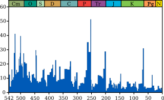
Millions of years ago
The blue graph shows the apparent percentage (not the absolute number) of marine animal genera becoming extinct during any given time interval. It does not represent all marine species, just those that are readily fossilized. The labels of the traditional "Big Five" extinction events and the more recently recognised End-Capitanian extinction event are clickable hyperlinks; see Extinction event for more details.

The Triassic–Jurassic extinction event marks the boundary between the Triassic and Jurassic periods, 201.3 million years ago, and is one of the major extinction events of the Phanerozoic eon, profoundly affecting life on land and in the oceans. In the seas, a whole class (conodonts) and 23–34% of marine genera disappeared. On land, all archosaurs other than crocodylomorphs (Sphenosuchia and Crocodyliformes) and Avemetatarsalia (pterosaurs and dinosaurs), some remaining therapsids, and many of the large amphibians became extinct.

Effects

This event vacated terrestrial ecological niches, allowing the dinosaurs to assume the dominant roles in the Jurassic period. This event happened in less than 10,000 years and occurred just before Pangaea started to break apart. In the area of Tübingen (Germany), a Triassic–Jurassic bonebed can be found, which is characteristic for this boundary.

The extinction event marks a floral turnover as well. About 60% of the diverse monosaccate and bisaccate pollen assemblages disappear at the Tr–J boundary, indicating a major extinction of plant genera. Early Jurassic pollen assemblages are dominated by Corollina, a new genus that took advantage of the empty niches left by the extinction.

Statistical analysis of marine losses at this time suggests that the decrease in diversity was caused more by a decrease in speciation than by an increase in extinctions.

Marine vertebrates

Fish did not suffer a mass extinction at the end of the Triassic. The late Triassic in general did experience a gradual drop in actinopterygiian diversity after an evolutionary explosion in the middle Triassic. Though this may have been due to falling sea levels or the Carnian pluvial event, it may instead be a result of sampling bias considering that middle Triassic fish have been more extensively studied than late Triassic fish. Despite the apparent drop in diversity, neopterygiians (which include most modern bony fish) suffered less than more "primitive" actinopterygiians, indicating a biological turnover where modern groups of fish started to supplant earlier groups.

Like fish, marine reptiles experienced a substantial drop in diversity between the middle Triassic and the Jurassic. However, their extinction rate at the Triassic–Jurassic boundary was not elevated. The highest extinction rates experienced by Mesozoic marine reptiles actually occurred at the end of the Ladinian stage, which corresponds to the end of the middle Triassic. The only marine reptile families which went extinct at or slightly before the Triassic–Jurassic boundary were the placochelyids (the last family of placodonts), and giant ichthyosaurs such as shastasaurids and shonisaurids. Nevertheless, some authors have argued that the end of the Triassic acted as a genetic "bottleneck" for ichthyosaurs, which never regained the level of anatomical diversity and disparity which they possessed during the Triassic.

Terrestrial vertebrates

One of the earliest pieces of evidence for a late Triassic extinction was a major turnover in terrestrial tetrapods such as amphibians, reptiles, and synapsids. Edwin H. Colbert drew parallels between the system of extinction and adaptation between the Triassic–Jurassic and Cretaceous-Paleogene boundaries. He recognized how dinosaurs, lepidosaurs (lizards and their relatives), and crocodyliforms (crocodilians and their relatives) filled the niches of more ancient groups of amphibians and reptiles which were extinct by the start of the Jurassic. Olson (1987) estimated that 42% of all terrestrial tetrapods went extinct at the end of the Triassic, based on his studies of faunal changes in the Newark Supergroup of eastern North America. More modern studies have debated whether the turnover in Triassic tetrapods was abrupt at the end of the Triassic, or instead more gradual.

During the Triassic, amphibians were mainly represented by large, crocodile-like members of the order Temnospondyli. Although the earliest lissamphibians (modern amphibians like frogs and salamanders) did appear during the Triassic, they would become more common in the Jurassic while the temnospondyls diminished in diversity past the Triassic–Jurassic boundary. Although the decline of temnospondyls did send shockwaves through freshwater ecosystems, it was probably not as abrupt as some authors have suggested. Brachyopoids, for example, survived until the Cretaceous according to new discoveries in the 1990s. Several temnospondyl groups did go extinct near the end of the Triassic despite earlier abundance, but it is uncertain how close their extinctions were to the end of the Triassic. The last known metoposaurids ("Apachesaurus") were from the Redonda Formation, which may have been early Rhaetian or late Norian. Gerrothorax, the last known plagiosaurid, has been found in rocks which are probably (but not certainly) Rhaetian, while a capitosaur humerus was found in Rhaetian-age deposits in 2018. Therefore, plagiosaurids and capitosaurs were likely victims of an extinction at the very end of the Triassic, while most other temnospondyls were already extinct.

Terrestrial reptile faunas were dominated by archosauromorphs during the Triassic, particularly phytosaurs and members of Pseudosuchia (the reptile lineage which leads to modern crocodilians). In the early Jurassic and onwards, dinosaurs and pterosaurs became the most common land reptiles, while small reptiles were mostly represented by lepidosauromorphs (such as lizards and tuatara relatives). Among pseudosuchians, only small crocodylomorphs did not go extinct by the end of the Triassic, with both dominant herbivorous subgroups (such as aetosaurs) and carnivorous ones (rauisuchids) having died out. Phytosaurs, drepanosaurs, trilophosaurids, tanystropheids, and procolophonids, which were other common reptiles in the late Triassic, had also become extinct by the start of the Jurassic. However, pinpointing the extinction of these different land reptile groups is difficult, as the last period of the Triassic (the Rhaetian) and the first period of the Jurassic (the Hettangian) each have few records of large land animals. Out of the different groups known to have gone extinct in the late Triassic, only phytosaurs, procolophonids, and possibly some basal paracrocodylomorphs are known from fossils considered to be near the Triassic-Jurassic boundary, and other groups may have died out earlier.

Current theories

Several explanations for this event have been suggested, but all have unanswered challenges.

Gradual processes

Gradual climate change, sea-level fluctuations, or a pulse of oceanic acidification during the late Triassic may have reached a tipping point. However, the effect of such processes on Triassic animal and plant groups is not well understood. 

The extinctions at the end of the Triassic were initially attributed to gradually changing environments. Within his 1958 study recognizing biological turnover between the Triassic and Jurassic, Edwin H. Colbert's 1958 proposal was that this extinction was a result of geological processes decreasing the diversity of land biomes. He considered the Triassic period to be an era of the world experiencing a variety of environments, from towering highlands to arid deserts to tropical marshes. On the other hand, the Jurassic period was much more uniform both in climate and elevation due to excursions by shallow seas.

Later studies noted a clear trend towards increased aridification towards the end of the Triassic. Although high-latitude areas like Greenland and Australia actually became wetter, most of the world experienced more drastic changes in climate as indicated by geological evidence. This evidence includes an increase in carbonate and evaporite deposits (which are most abundant in dry climates) and a decrease in coal deposits (which primarily form in humid environments such as coal forests). In addition, the climate may have become much more seasonal, with long droughts interrupted by severe monsoons.

Geological formations in Europe seem to indicate a drop in sea levels in the late Triassic, and then a rise in the early Jurassic. Although falling sea levels have sometimes been considered a culprit for marine extinctions, evidence is inconclusive since many sea level drops in geological history are not correlated with increased extinctions. However, there is still some evidence that marine life was affected by secondary processes related to falling sea levels, such as decreased oxygenation (caused by sluggish circulation), or increased acidification. These processes do not seem to have been worldwide, but they may explain local extinctions in European marine fauna.

Extraterrestrial impact

The Manicouagan reservoir in Quebec, a massive crater formed by a Late Triassic impact. Radiometric dating has determined that it is about 13 million years older than the Triassic–Jurassic boundary, and thus an unlikely candidate for a mass extinction.
 
Some have theorized that an impact from an asteroid or comet may have caused the Triassic–Jurassic extinction, similar to the extraterrestrial object which was the main factor in the Cretaceous–Paleogene extinction about 66 million years ago, as evidenced by the Chicxulub crater in Mexico. However, so far no impact crater of sufficient size has been dated to precisely coincide with the Triassic–Jurassic boundary. 

Nevertheless, the late Triassic did experience several impacts, including the second-largest confirmed impact in the Mesozoic. The Manicouagan Reservoir in Quebec is one of the most visible large impact craters on Earth, and at 100 km (62 mi) in diameter it is tied with the Eocene Popigai crater in Siberia as the fourth-largest impact crater on Earth. Olsen et al. (1987) were the first scientists to link the Manicouagan crater to the Triassic–Jurassic extinction, citing its age which at the time was roughly considered to be late Triassic. More precise radiometric dating by Hodych & Dunning (1992) has shown that the Manicouagan impact occurred about 214 million years ago, about 13 million years before the Triassic–Jurassic boundary. Therefore, it could not have been responsible for an extinction precisely at the Triassic–Jurassic boundary. Nevertheless, the Manicougan impact did have a widespread effect on the planet; a 214-million-year-old ejecta blanket of shocked quartz has been found in rock layers as far away as England and Japan. There is still a possibility that the Manicouagan impact was responsible for a small extinction midway through the late Triassic at the Carnian–Norian boundary, although the disputed age of this boundary (and whether an extinction actually occurred in the first place) makes it difficult to correlate the impact with extinction. Onoue et al. (2016) alternatively proposed that the Manicouagan impact was responsible for a marine extinction in the middle of the Norian which impacted radiolarians, sponges, conodonts, and Triassic ammonoids. Thus, the Manicouagan impact may have been partially responsible for the gradual decline in the latter two groups which culminated in their extinction at the Triassic–Jurassic boundary. The boundary between the Adamanian and Revueltian land vertebrate faunal zones, which involved extinctions and faunal changes in tetrapods and plants, was possibly also caused by the Manicouagan impact, although discrepancies between magnetochronological and isotopic dating lead to some uncertainty.

Other Triassic craters are closer to the Triassic–Jurassic boundary but also much smaller than the Manicouagan reservoir. The eroded Rochechouart crater in France has most recently been dated to 201±2 million years ago, but at 25 km (16 mi) across (possibly up to 50 km (30 mi) across originally), it appears to be too small to have affected the ecosystem. Other putative or confirmed Triassic craters include the 80 km (50 mi) wide Puchezh-Katunki crater in Eastern Russia (though it may be Jurassic in age), the 40 km (25 mi) wide Saint Martin crater in Manitoba, the 15 km (9 mi) wide Obolon' crater in Ukraine, and the 9 km (6 mi) wide Red Wing Creek structure in North Dakota. Spray et al. (1998) noted an interesting phenomenon, that being how the Manicoagan, Rochechoart, and Saint Martin craters all seem to be at the same latitude, and that the Obolon' and Red Wing craters form parallel arcs with the Rochechoart and Saint Martin craters, respectively. Spray and his colleagues hypothesized that the Triassic experienced a "multiple impact event", a large fragmented asteroid or comet which broke up and impacted the earth in several places at the same time. Such an impact has been observed in the present day, when Comet Shoemaker-Levy 9 broke up and hit Jupiter in 1992. However, the "multiple impact event" hypothesis for Triassic impact craters has not been well-supported; Kent (1998) noted that the Manicouagan and Rochechoart craters were formed in eras of different magnetic polarity, and radiometric dating of the individual craters has shown that the impacts occurred millions of years apart.

Volcanic eruptions

Massive volcanic eruptions, specifically the flood basalts of the Central Atlantic Magmatic Province (CAMP), would release carbon dioxide or sulfur dioxide and aerosols, which would cause either intense global warming (from the former) or cooling (from the latter). The record of CAMP degassing shows several distinct pulses of carbon dioxide immediately following each major pulse of magmatism, at least two of which amount to a doubling of atmospheric CO2.

The isotopic composition of fossil soils of the Late Triassic and Early Jurassic has been tied to a large negative carbon isotope excursion (Whiteside et al. 2010). Carbon isotopes of lipids (n-alkanes) derived from leaf wax and lignin, and total organic carbon from two sections of lake sediments interbedded with the CAMP in eastern North America have shown carbon isotope excursions similar to those found in the mostly marine St. Audrie’s Bay section, Somerset, England; the correlation suggests that the end-Triassic extinction event began at the same time in marine and terrestrial environments, slightly before the oldest basalts in eastern North America but simultaneous with the eruption of the oldest flows in Morocco (Also suggested by Deenen et al., 2010), with both a critical CO
2
greenhouse and a marine biocalcification crisis.

Contemporaneous CAMP eruptions, mass extinction, and the carbon isotopic excursions are shown in the same places, making the case for a volcanic cause of a mass extinction. The catastrophic dissociation of gas hydrates (suggested as one possible cause of the largest mass extinction of all time, the so-called "Great Dying" at the end of the Permian Period) may have exacerbated greenhouse conditions.

Some scientists reject the volcanic eruption theory, because the Newark Supergroup, a section of rock that records the Triassic–Jurassic boundary, contains no ash-fall horizons and the first basalt flows lie around 10 m above the transition zone. However, updated dating protocol and wider sampling has generally confirmed that most (but not all) volcanic activity occurred before the boundary.

Alvarez hypothesis

From Wikipedia, the free encyclopedia
 
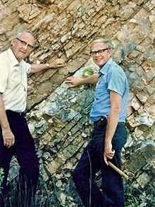
Luis, left, and his son Walter Alvarez, right, at the K-T Boundary in Gubbio, Italy, 1981
 
The Alvarez hypothesis posits that the mass extinction of the dinosaurs and many other living things during the Cretaceous–Paleogene extinction event was caused by the impact of a large asteroid on the Earth. Prior to 2013, it was commonly cited as having happened about 65 million years ago, but Renne and colleagues (2013) gave an updated value of 66 million years. Evidence indicates that the asteroid fell in the Yucatán Peninsula, at Chicxulub, Mexico. The hypothesis is named after the father-and-son team of scientists Luis and Walter Alvarez, who first suggested it in 1980. Shortly afterwards, and independently, the same was suggested by Dutch paleontologist Jan Smit.

In March 2010, an international panel of scientists endorsed the asteroid hypothesis, specifically the Chicxulub impact, as being the cause of the extinction. A team of 41 scientists reviewed 20 years of scientific literature and in so doing also ruled out other theories such as massive volcanism. They had determined that a 10–15 km (6–9 mi) space rock hurtled into earth at Chicxulub. For comparison, the Martian moon Phobos is 11 km (7 mi) and Mount Everest is just under 9 km (5.6 mi). The collision would have released the same energy as 100,000,000 megatonnes of TNT (4.2×10²³ J), over a billion times the energy of the atomic bombs dropped on Hiroshima and Nagasaki.

A 2016 drilling project into the peak ring of the crater strongly supported the hypothesis, and confirmed various matters that had been unclear until that point. These included the fact that the peak ring comprised granite (a rock found deep within the earth) rather than typical sea floor rock, which had been shocked, melted, and ejected to the surface in minutes, and evidence of colossal seawater movement directly afterwards from sand deposits. Crucially the cores also showed a near complete absence of gypsum, a sulfate-containing rock, which would have been vaporized and dispersed as an aerosol into the atmosphere, confirming the presence of a probable link between the impact and global longer-term effects on the climate and food chain.

History

In 1980, a team of researchers led by Nobel prize-winning physicist Luis Alvarez, his son, geologist Walter Alvarez, and chemists Frank Asaro and Helen Vaughn Michel discovered that sedimentary layers found all over the world at the Cretaceous–Paleogene boundary (K–Pg boundary, formerly called Cretaceous–Tertiary or K–T boundary) contain a concentration of iridium hundreds of times greater than normal. Iridium is extremely rare in the Earth's crust because it is very dense and has the affinity for iron that characterizes the siderophile elements (see Goldschmidt classification), and therefore most of it sank into the Earth's core while the earth was still molten. The Alvarez team suggested that an asteroid struck the earth at the time of the Cretaceous–Paleogene boundary.

Previously, in a 1953 publication, geologists Allan O. Kelly and Frank Dachille analyzed global geological evidence suggesting that one or more giant asteroids impacted the Earth, causing an angular shift in its axis, global floods, fire, atmospheric occlusion, and the extinction of the dinosaurs. There were other earlier speculations on the possibility of an impact event, but without strong confirming evidence.

Evidence

The evidence for the Alvarez impact hypothesis is supported by chondritic meteorites and asteroids which contain a much higher iridium concentration than the Earth's crust. The isotopic ratio of iridium in meteorites is similar to that of the Cretaceous–Paleogene boundary layer but significantly different from the ratio in the Earth's crust. Chromium isotopic anomalies found in Cretaceous–Paleogene boundary sediments are similar to that of an asteroid or a comet composed of carbonaceous chondrites. Shocked quartz granules, glass spherules and tektites, indicative of an impact event, are common in the Cretaceous–Paleogene boundary, especially in deposits from around the Caribbean. All of these constituents are embedded in a layer of clay, which the Alvarez team interpreted as the debris spread all over the world by the impact. The location of the impact was unknown when the Alvarez team developed their hypothesis, but later scientists discovered the Chicxulub Crater in the Yucatán Peninsula, now considered the likely impact site.

Badlands near Drumheller, Alberta where erosion has exposed the K–Pg boundary.
 
Using estimates of the total amount of iridium in the K–Pg layer, and assuming that the asteroid contained the normal percentage of iridium found in chondrites, the Alvarez team went on to calculate the size of the asteroid. The answer was about 10 kilometers (6 mi) in diameter, about the size of Manhattan. Such a large impact would have had approximately the energy of 100 million megatons, i.e. about 2 million times as great as the most powerful thermonuclear bomb ever tested.

Paul Renne of the Berkeley Geochronology Center has reported that the date of the asteroid event is 66,038,000 years ago, plus or minus 11,000 years, based on the radioactive decay of argon. He further posits that the mass extinction of dinosaurs occurred within 33,000 years of this date.

In April 2019 a paper was published in PNAS which describes evidence from a fossil site in North Dakota that the authors say provides a "postimpact snapshot" of events after the asteroid collision "including ejecta accretion and faunal mass death". The team found that the tektites that had peppered the area were present in amber found on the site and were also embedded in the gills of about 50 percent of the fossil fish. They were also able to find traces of iridium. The authors – who include Walter Alvarez – postulate that shock of the impact, equivalent to an earthquake of magnitude 10 or 11, may have led to seiches, oscillating movements of water in lakes, bays, or gulfs, that would have reached the site in North Dakota within minutes or hours of the impact. This would have led to the rapid burial of organisms under a thick layer of sediment. Coauthor David Burnham of the University of Kansas was quoted as saying “They’re not crushed, it’s like an avalanche that collapses almost like a liquid, then sets like concrete. They were killed pretty suddenly because of the violence of that water. We have one fish that hit a tree and was broken in half.”

Impact

The most easily observable consequence of such an impact would be a vast dust cloud which would block sunlight and prevent photosynthesis for a few years, an event called an impact winter. This would account for the extinction of plants and phytoplankton and of all organisms dependent on them (including predatory animals as well as herbivores). But small creatures whose food chains were based on detritus would have a reasonable chance of survival. It is estimated that sulfuric acid aerosols were injected into the stratosphere, leading to a 10–20% reduction of solar transmission normal for that period. It would have taken at least ten years for those aerosols to dissipate.

Global firestorms may have resulted as incendiary fragments from the blast fell back to Earth. Analyses of fluid inclusions in ancient amber suggest that the oxygen content of the atmosphere was very high (30–35%) during the late Cretaceous. This high O2 level would have supported intense combustion. The level of atmospheric O2 plummeted in the early Paleogene Period. If widespread fires occurred, they would have increased the CO2 content of the atmosphere and caused a temporary greenhouse effect once the dust cloud settled, and this would have exterminated the most vulnerable survivors of the "long winter". 

The impact may also have produced acid rain, depending on what type of rock the asteroid struck. However, recent research suggests this effect was relatively minor. Chemical buffers would have limited the changes, and the survival of animals vulnerable to acid rain effects (such as frogs) indicate this was not a major contributor to extinction.

Impact hypotheses can only explain very rapid extinctions, since the dust clouds and possible sulphuric aerosols would wash out of the atmosphere in a fairly short time – possibly under ten years.
Although further studies of the K–Pg layer consistently show the excess of iridium, the idea that the dinosaurs were exterminated by an asteroid remained a matter of controversy among geologists and paleontologists for more than a decade.

Criticism

Amongst others, Charles B. Officer and Gerta Keller have been critical of the theory.

Officer and Jake Page describe in their The Great Dinosaur Extinction Controversy how
  • A dust cloud from an asteroid impact could not have existed because many marine plants that require uninterrupted sunlight were unaffected
  • The iridium deposits appear to be the work of volcanoes
  • The extinctions occurred gradually, not instantaneously "Even if a meteoric impact occurred at K-T time, it simply could not explain the extinction record."
  • The Chicxulub structure is a volcanic sequence of late Cretaceous age; it is not an impact meltsheet of Cretaceous-Tertiary age
  • Papers disputing the Alvarez hypothesis were summarily rejected by journals without review
Keller has focussed on Deccan Traps volcanism as a likely cause of a more gradual extinction.

2016 Chicxulub crater drilling project

In 2016, a scientific drilling project drilled deep into the peak ring of the Chicxulub impact crater, to obtain rock core samples from the impact itself. The discoveries were widely seen as confirming current theories related to both the crater impact, and its effects. They confirmed that the rock composing the peak ring had been subjected to immense pressures and forces and had been melted by immense heat and shocked by immense pressure from its usual state into its present form in just minutes; the fact that the peak ring was made of granite was also significant, since granite is not a rock found in sea-floor deposits, it originates much deeper in the earth and had been ejected to the surface by the immense pressures of impact; that gypsum, a sulfate-containing rock that is usually present in the shallow seabed of the region, had been almost entirely removed and must therefore have been almost entirely vaporized and entered the atmosphere, and that the event was immediately followed by a huge megatsunami (a massive movement of sea waters) sufficient to lay down the largest known layer of sand separated by grain size directly above the peak ring. 

These strongly support the hypothesis that the impactor was large enough to create a 120-mile peak ring, to melt, shock and eject basement granite from the midcrust deep within the earth, to create colossal water movements, and to eject an immense quantity of vaporized rock and sulfates into the atmosphere, where they would have persisted for a long time. This global dispersal of dust and sulfates would have led to a sudden and catastrophic effect on the climate worldwide, large temperature drops, and devastated the food chain.

Education reform

From Wikipedia, the free encyclopedia https://en.wikipedia.org/wiki/Education_reform ...