Search This Blog

Wednesday, July 17, 2019

United States Geological Survey

From Wikipedia, the free encyclopedia

United States Geological Survey (USGS)
Seal of the United States Geological Survey.svg
Seal of the United States Geological Survey
USGS logo green.svg
Official identifier of the U.S. Geological Survey
Flag of the United States Geological Survey.png
Flag of the United States Geological Survey
Agency overview
FormedMarch 3, 1879; 140 years ago (as Geological Survey)
JurisdictionUnited States
HeadquartersJohn W. Powell National Center
Reston, Virginia, U.S.
38.9470°N 77.3675°WCoordinates: 38.9470°N 77.3675°W
Employees8,670 (2009)
Annual budget$1.16 billion (FY2019) H.J.Res. 31
Agency executive
Parent agencyUnited States Department of the Interior
WebsiteUSGS.gov

The United States Geological Survey (USGS, formerly simply Geological Survey) is a scientific agency of the United States government. The scientists of the USGS study the landscape of the United States, its natural resources, and the natural hazards that threaten it. The organization has four major science disciplines, concerning biology, geography, geology, and hydrology. The USGS is a fact-finding research organization with no regulatory responsibility.

The USGS is a bureau of the United States Department of the Interior; it is that department's sole scientific agency. The USGS employs approximately 8,670 people[1] and is headquartered in Reston, Virginia. The USGS also has major offices near Lakewood, Colorado, at the Denver Federal Center, and Menlo Park, California.

The current motto of the USGS, in use since August 1997, is "science for a changing world". The agency's previous slogan, adopted on the occasion of its hundredth anniversary, was "Earth Science in the Public Service".

Programs

The USGS headquarters in Reston, Virginia
 
USGS gauging station 03221000 on the Scioto River below O'Shaughnessy Dam near Dublin, Ohio
 
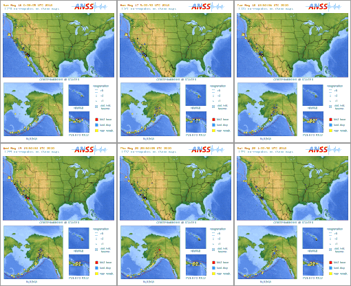
Earthquake animations from 16 May 2010 to 22 May 2010
 
Recent earthquakes around the world, from 23 April 2010 to 23 May 2010
 
Since 2012, the USGS science focus is directed at six topical "Mission Areas", namely (1) Climate and Land Use Change, (2) Core Science Systems, (3) Ecosystems, (4) Energy and Minerals and Environmental Health, (5) Natural Hazards, and (6) Water. In December 2012, the USGS split the Energy and Minerals and Environmental Health Mission Area resulting in seven topical Mission Areas, with the two new areas being: Energy and Minerals and Environmental Health. Administratively, it is divided into a Headquarters unit and six Regional Units. Other specific programs include:
  • Earthquake Hazards Program monitors earthquake activity worldwide. The National Earthquake Information Center (NEIC) in Golden, Colorado on the campus of the Colorado School of Mines detects the location and magnitude of global earthquakes. The USGS also runs or supports several regional monitoring networks in the United States under the umbrella of the Advanced National Seismic System (ANSS). The USGS informs authorities, emergency responders, the media, and the public, both domestic and worldwide, about significant earthquakes. It also maintains long-term archives of earthquake data for scientific and engineering research. It also conducts and supports research on long-term seismic hazards. USGS has released the UCERF California earthquake forecast.
  • As of 2005, the agency is working to create a National Volcano Early Warning System by improving the instrumentation monitoring the 169 volcanoes in U.S. territory and by establishing methods for measuring the relative threats posed at each site.
  • The USGS National Geomagnetism Program monitors the magnetic field at magnetic observatories and distributes magnetometer data in real time.
  • The USGS collaborates with Canadian and Mexican government scientists, along with the Commission for Environmental Cooperation, to produce the North American Environmental Atlas, which is used to depict and track environmental issues for a continental perspective.
  • The USGS operates the streamgaging network for the United States, with over 7400 streamgages. Real-time streamflow data are available online.
  • National Climate Change and Wildlife Science Center (NCCWSC) implements partner-driven science to improve understanding of past and present land use change, develops relevant climate and land use forecasts, and identifies lands, resources, and communities that are most vulnerable to adverse impacts of change from the local to global scale.
  • Since 1962, the Astrogeology Research Program has been involved in global, lunar, and planetary exploration and mapping.
  • In collaboration with Stanford University, the USGS also operates the USGS-Stanford Ion Microprobe Laboratory, a world-class analytical facility for U-(Th)-Pb geochronology and trace element analyses of minerals and other earth materials.
  • USGS operates a number of water related programs, notably the National Streamflow Information Program and National Water-Quality Assessment Program. USGS Water data is publicly available from their National Water Information System database.
  • The USGS also operates the National Wildlife Health Center, whose mission is "to serve the nation and its natural resources by providing sound science and technical support, and to disseminate information to promote science-based decisions affecting wildlife and ecosystem health. The NWHC provides information, technical assistance, research, education, and leadership on national and international wildlife health issues." It is the agency primarily responsible for surveillance of H5N1 avian influenza outbreaks in the United States. The USGS also runs 17 biological research centers in the United States, including the Patuxent Wildlife Research Center.
  • The USGS is investigating collaboration with the social networking site Twitter to allow for more rapid construction of ShakeMaps.

Topographic mapping

1892 15-minute map (or topographic sheet) of the Mount Marcy area of the Adirondacks in New York State from the first decades of the USGS
 
The USGS produces several national series of topographic maps which vary in scale and extent, with some wide gaps in coverage, notably the complete absence of 1:50,000 scale topographic maps or their equivalent. The largest (both in terms of scale and quantity) and best-known topographic series is the 7.5-minute, 1:24,000 scale, quadrangle, a non-metric scale virtually unique to the United States. Each of these maps covers an area bounded by two lines of latitude and two lines of longitude spaced 7.5 minutes apart. Nearly 57,000 individual maps in this series cover the 48 contiguous states, Hawaii, U.S. territories, and areas of Alaska near Anchorage, Fairbanks, and Prudhoe Bay. The area covered by each map varies with the latitude of its represented location due to convergence of the meridians. At lower latitudes, near 30° north, a 7.5-minute quadrangle contains an area of about 64 square miles (166 km2). At 49° north latitude, 49 square miles (127 km2) are contained within a quadrangle of that size. As a unique non-metric map scale, the 1:24,000 scale naturally requires a separate and specialized romer scale for plotting map positions. In recent years, budget constraints have forced the USGS to rely on donations of time by civilian volunteers in an attempt to update its 7.5-minute topographic map series, and USGS stated outright in 2000 that the program was to be phased out in favor of The National Map (not to be confused with the National Atlas of the United States produced by the Department of the Interior, one of whose bureaus is USGS). 

An older series of maps, the 15-minute series, was once used to map the contiguous 48 states at a scale of 1:62,500, but was discontinued some time ago for maps covering the continental United States. Each map was bounded by two parallels and two meridians spaced 15 minutes apart—the same area covered by four maps in the 7.5-minute series. The 15-minute series, at a scale of 1:63,360 (one inch representing one mile), remains the primary topographic quadrangle for the state of Alaska (and only for that particular state). Nearly 3,000 maps cover 97% of the state. The United States remains virtually the only developed country in the world without a standardized civilian topographic map series in the standard 1:25,000 or 1:50,000 metric scales, making coordination difficult in border regions (the U.S. military does issue 1:50,000 scale topo maps of the continental United States, though only for use by members of its defense forces). 

The next-smallest topographic series, in terms of scale, is the 1:100,000 series. These maps are bounded by two lines of longitude and two lines of latitude. However, in this series, the lines of latitude are spaced 30 minutes apart and the lines of longitude are spaced 60 minutes, which is the source of another name for these maps; the 30 x 60-minute quadrangle series. Each of these quadrangles covers the area contained within 32 maps in the 7.5-minute series. The 1:100,000 scale series is unusual in that it employs the Metric system primarily. One centimeter on the map represents one kilometer of distance on the ground. Contour intervals, spot elevations, and horizontal distances are also specified in meters. 

The final regular quadrangle series produced by the USGS is the 1:250,000 scale topographic series. Each of these quadrangles in the conterminous United States measures 1 degree of latitude by 2 degrees of longitude. This series was produced by the U.S. Army Map Service in the 1950s, prior to the maps in the larger-scale series, and consists of 489 sheets, each covering an area ranging from 8,218 square miles (21,285 km2) at 30° north to 6,222 square miles (16,115 km2) at 49° north. Hawaii is mapped at this scale in quadrangles measuring 1° by 1°. 

USGS topographic quadrangle maps are marked with grid lines and tics around the map collar which make it possible to identify locations on the map by several methods, including the graticule measurements of longitude and latitude, the township and section method within the Public Land Survey System, and cartesian coordinates in both the State Plane Coordinate System and the Universal Transverse Mercator coordinate system

Other specialty maps have been produced by the USGS at a variety of scales. These include county maps, maps of special interest areas, such as the national parks, and areas of scientific interest. 

A number of Internet sites have made these maps available on the web for affordable commercial and professional use. Because works of the U.S. government are in the public domain, it is also possible to find many of these maps for free at various locations on the Internet. Georeferenced map images are available from the USGS as digital raster graphics (DRGs) in addition to digital data sets based on USGS maps, notably digital line graphs (DLGs) and digital elevation models (DEMs). 

In 2015, the USGS unveiled the topoView website, a new way to view their entire digitized collection of over 178,000 maps from 1884–2006. The site is an interactive map of the United States that allows users to search or move around the map to find the USGS collection of maps for a specific area. Users may then view the maps in great detail and download them if desired.

The National Map and U.S. Topo

In 2008 the USGS abandoned traditional methods of surveying, revising, and updating topographic maps based on aerial photography and field checks. Today's U.S. Topo quadrangle (1:24,000) maps are mass-produced, using automated and semiautomated processes, with cartographic content supplied from the National GIS Database. In the two years from June 2009 to May 2011, the USGS produced nearly 40,000 maps, more than 80 maps per work day. Only about two hours of interactive work are spent on each map, mostly on text placement and final inspection; there are essentially no field checks or field inspections to confirm map details.

While much less expensive to compile and produce, the revised digital U.S. topo maps have been criticized for a lack of accuracy and detail in comparison to older generation maps based on aerial photo survey and field checks. As the digital databases were not designed for producing general purpose maps, data integration can be a problem when retrieved from sources with different resolutions and collection dates. Man-made features once recorded by direct field observation are not in any public domain national database, and are frequently omitted from the newest generation digital topo maps, including windmills, mines and mineshafts, water tanks, fence lines, survey marks, parks, recreational trails, buildings, boundaries, pipelines, telephone lines, power transmission lines, and even railroads. Additionally, the digital map's use of existing software may not properly integrate different feature classes or prioritize and organize text in areas of crowded features, obscuring important geographic details. As a result, some have noted that the U.S. Topo maps currently fall short of traditional topographic map presentation standards achieved in maps drawn from 1945 to 1992.

USGS Hydrologic Instrumentation Facility

The Hydrologic Instrumentation Facility (HIF) has four sections within its organizational structure; the Field Services Section which includes the warehouse, repair shop, and Engineering Unit; the Testing Section which includes the Hydraulic Laboratory, testing chambers, and Water Quality Laboratory; the Information Technology Section which includes computer support and the Drafting Unit; and the Administrative Section.

The HIF was given national responsibility for the design, testing, evaluation, repair, calibration, warehousing, and distribution of hydrologic instrumentation. Distribution is accomplished by direct sales and through a rental program. The HIF supports data collection activities through centralized warehouse and laboratory facilities. The HIF warehouse provides hydrologic instruments, equipment, and supplies for USGS as well as Other Federal Agencies (OFA) and USGS Cooperators. The HIF also tests, evaluates, repairs, calibrates, and develops hydrologic equipment and instruments. The HIF Hydraulic Laboratory facilities include a towing tank, jet tank, pipe flow facility, and tilting flume. In addition, the HIF provides training and technical support for the equipment it stocks.

The Engineering Group seeks out new technology and designs for instrumentation that can work more efficiently, be more accurate, and or be produced at a lower cost than existing instrumentation. HIF works directly with vendors to help them produce products that will meet the mission needs of the USGS. For instrument needs not currently met by a vendor, the Engineering Group designs, tests, and issues contracts to have HIF designed equipment made. Sometimes HIF will patent a new design in the hope that instrument vendors will buy the rights and mass-produce the instrument at a lower cost to everyone.

USGS publications

USGS researchers publish the results of their science in a variety of ways. Many researchers publish their science in peer-reviewed scientific journals as well as in one of a variety of series that includes series for preliminary results, maps data, and final results. These series include:
  • Biological Science Report (BSR): Record significant scientific interpretations and findings, usually of lasting scientific interest, addressing a wide variety of topics relevant to Biological Resources Discipline (BRD) investigations and research. May include extensive data or theoretical analyses. Reports published by the U.S. Biological Survey and later by the U.S. Geological Survey. The report series began in 1995 and continued through 2003.
  • Bulletin (B): Significant data and interpretations of lasting scientific interest but generally narrower in scope than professional papers. Results of resource studies, geologic or topographic studies, and collections of short papers on related topics.
  • Circular (CIR/C): A wide variety of topics covered concisely and clearly to provide a synthesis of understanding about processes, geographic areas, issues, or USGS programs. The Circular should be aimed at enhancing knowledge and understanding among general audiences, decision makers, university students, and scientists in related fields.
  • Circum-Pacific Map (CP): Multicolor equal-area maps at scales of 1:10,000,000 for the Northwest, Northeast, Southwest, Southeast quadrants of the Pacific and the Arctic and Antarctic regions, and of 1:17,000,000 for the whole Pacific Basin. The series consists of base, geographic, geodynamic, plate-tectonic, geologic, tectonic, mineral-resources, and energy-resources maps, as well as other miscellaneous maps.
  • Coal Investigations (COAL/C-) Map: Origin, character, and resource potential of coal deposits shown by geologic maps, structure contours, cross sections, columnar sections, and measured coal sections, where appropriate. Text on same sheet or in an accompanying pamphlet.
  • Data Series (DS): The Data Series is intended for release of basic data sets, databases, and multimedia or motion graphics. This series can be used for videos, computer programs, and collections of digital photographs.
  • General Interest Publication (GIP): A wide variety of topics covered concisely and clearly in a variety of formats. Focus is on USGS programs, projects, and services and general scientific information of public interest. The series covers a broad range of topics in a variety of media, including pamphlets, postcards, posters, videos, teacher kits, CD/DVDs, bookmarks, and interactive and motion graphics. Previously called "General Interest Publications".
  • Geologic Quadrangle (GQ) Map: Detailed geologic maps depicting areas of special importance to the solution of geologic problems. May portray bedrock or surficial units, or both. May include brief texts, structure sections, and columnar sections. 71/2- or 15-minute quadrangles printed in multicolor on topographic bases that meet National Map Accuracy standards.
  • Geophysical Investigations (GP) Map: Chiefly the results of aeromagnetic and (or) gravity surveys shown by contours. Area depicted may range in size from a few square miles to an entire country. Single or multiple sheets.
  • Land Use and Land Cover (L) Map: Various categories of land use and cover, both artificial and natural, for use by geographers, land-use planners, and others. Planimetric maps at scales of 1:250,000 or 1:100,000 on a single sheet.
  • Mineral Investigations Resource (MR) Map: Information on mineral occurrences, mineral resources, mines and prospects, commodities, and target areas of possible resources other than coal, petroleum, or natural gas. Small scale (1:250,000 or smaller).
  • Miscellaneous Field Studies (MF) Map: Rapidly prepared, low-budget maps in a broad range of presentations in terms of portrayal, completeness, interpretations, draftsmanship, scale, and area coverage. Single or multiple sheets.
  • Miscellaneous Investigations/ Geologic Investigations (I) Series: High-quality maps and charts of varied subject matter such as bathymetry, geology, hydrogeology, landforms, land-use classification, vegetation, and others including maps of planets, the Moon, and other satellites. Various scales. Topographic or planimetric bases; regular or irregular areas. May include a text printed as an accompanying pamphlet.
  • Oil and Gas Investigations (OC) Chart: Information about known or possible petroleum resources, presented as logs, correlation diagrams, graphs, and tables, but ordinarily not as maps. Single or multiple sheets. Text printed on same sheet or in an accompanying pamphlet.
  • Oil and Gas Investigations (OM) Map: Apply particularly to areas of known or possible petroleum resources. Typically include cross sections, columnar sections, structure contours, correlation diagrams, and information on wells drilled for oil and gas. Single or multiple sheets. Text usually on map sheet but sometimes printed as an accompanying pamphlet.
  • Open-File Report (OFR/OF): Interpretive information that needs to be released immediately; maps and reports (and their supporting data) that need to be released as supporting documentation because they are referenced, discussed, or interpreted in another information product; preliminary findings (pending a final map or report); interim computer programs and user guides; bibliographies.
  • Professional Paper (PP): Premier series of the USGS. Comprehensive reports of wide and lasting interest and scientific importance, characterized by thoroughness of study and breadth of scientific or geographic coverage. The series may include collections of related papers addressing different aspects of a single scientific topic, either issued together under one cover or separately as chapters.
  • Water-Resources Investigations Report (WRIR/WRI): Hydrologic information, mainly of local interest, intended for quick release. Book or map format. Varied scales.
  • Water-Supply Paper (WSP): Reports on all aspects of hydrology, including quality, recoverability, and use of water resources; statistical reports on streamflow, floods, groundwater levels, and water quality; and collections of short papers on related topics.
A complete listing of descriptions of USGS Series is available at the Alaska Division of Geological & Geophysical Surveys (ADGGS) website.

Locating USGS publications

The United States Geological Survey Library holds copies of current and historical USGS publications, and is the largest earth sciences library in the world. Most publications are available for inter-library loan within the United States. Under the Organic Act, which provided for the formation of the USGS, the library was given extra copies of all USGS publications when published to be used in exchange with other domestic and foreign geological agencies, making the acquisition of the USGS Library collection one of the most cost efficient libraries in the U.S. government.

USGS publications are available for purchase at USGS Store. Many USGS published reports are available to view and access on-line from the USGS Publications Warehouse, while many USGS publications are now available online (see Publications below).

Many older USGS publications have been scanned and digitized by such services as Google Books and the Hathi Trust and Internet Archive. An online search will quickly reveal if a digital version is available. All USGS publications are public domain.

History

Prompted by a report from the National Academy of Sciences, the USGS was created, by a last-minute amendment, to an act of Congress on March 3, 1879. It was charged with the "classification of the public lands, and examination of the geological structure, mineral resources, and products of the national domain". This task was driven by the need to inventory the vast lands added to the United States by the Louisiana Purchase in 1803 and the Mexican–American War in 1848.

The legislation also provided that the Hayden, Powell, and Wheeler surveys be discontinued as of June 30, 1879.

Clarence King, the first director of USGS, assembled the new organization from disparate regional survey agencies. After a short tenure, King was succeeded in the director's chair by John Wesley Powell.

Environmental impact of pesticides

From Wikipedia, the free encyclopedia
 
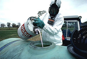
Preparing to spray a hazardous pesticide
 
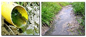
Drainage of fertilizers and pesticides into a stream
 
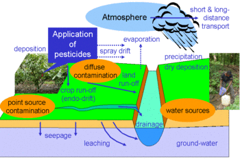
how pesticides are used
 
The impact of pesticides consists of the effects of pesticides on non-target species. Pesticides are chemical preparations used to kill fungal or animal pests. Over 98% of sprayed insecticides and 95% of herbicides reach a destination other than their target species, because they are sprayed or spread across entire agricultural fields. Runoff can carry pesticides into aquatic environments while wind can carry them to other fields, grazing areas, human settlements and undeveloped areas, potentially affecting other species. Other problems emerge from poor production, transport and storage practices. Over time, repeated application increases pest resistance, while its effects on other species can facilitate the pest's resurgence.

Each pesticide or pesticide class comes with a specific set of environmental concerns. Such undesirable effects have led many pesticides to be banned, while regulations have limited and/or reduced the use of others. Over time, pesticides have generally become less persistent and more species-specific, reducing their environmental footprint. In addition the amounts of pesticides applied per hectare have declined, in some cases by 99%. The global spread of pesticide use, including the use of older/obsolete pesticides that have been banned in some jurisdictions, has increased overall.

Agriculture and the environment

The arrival of humans in an area, to live or to conduct agriculture, necessarily has environmental impacts. These range from simple crowding out of wild plants in favor of more desirable cultivars to larger scale impacts such as reducing biodiversity by reducing food availability of native species, which can propagate across food chains. The use of agricultural chemicals such as fertilizer and des magnify those impacts. While advances in agrochemistry have reduced those impacts, for example by the replacement of long-lived chemicals with those that reliably degrade, even in the best case they remain substantial. These effects are magnified by the use of older chemistries and poor management practices.

History

While concern for ecotoxicology began with acute poisoning events in the late 19th century; public concern over the undesirable environmental effects of chemicals arose in the early 1960s with the publication of Rachel Carson′s book, Silent Spring. Shortly thereafter, DDT, originally used to combat malaria, and its metabolites were shown to cause population-level effects in raptorial birds. Initial studies in industrialized countries focused on acute mortality effects mostly involving birds or fish.

Data on pesticide usage remain scattered and/or not publicly available (3). The common practice of incident registration is inadequate for understanding the entirety of effects.

Since 1990, research interest has shifted from documenting incidents and quantifying chemical exposure to studies aimed at linking laboratory, mesocosm and field experiments. The proportion of effect-related publications has increased. Animal studies mostly focus on fish, insects, birds, amphibians and arachnids.

Since 1993, the United States and the European Union have updated pesticide risk assessments, ending the use of acutely toxic organophosphate and carbamate insecticides. Newer pesticides aim at efficiency in target and minimum side effects in nontarget organisms. The phylogenetic proximity of beneficial and pest species complicates the project.

One of the major challenges is to link the results from cellular studies through many levels of increasing complexity to ecosystems.

The concept (borrowed from nuclear physics) of a half-life has been utilized for pesticides in plants, and certain authors maintain that pesticide risk and impact assessment models rely on and are sensitive to information describing dissipation from plants. Half-life for pesticides is explained in two NPIC fact sheets. Known degradation pathways are through: photolysis, chemical dissociation, sorption, bioaccumulation and plant or animal metabolism. A USDA fact sheet published in 1994 lists the soil adsorption coefficient and soil half-life for then-commonly used pesticides.

Specific pesticide effects

Pesticide environmental effects
Pesticide/class Effect(s)
Organochlorine DDT/DDE Egg shell thinning in raptorial birds

Endocrine disruptor

Thyroid disruption properties in rodents, birds, amphibians and fish

Acute mortality attributed to inhibition of acetylcholine esterase activity
DDT Carcinogen

Endocrine disruptor
DDT/Diclofol, Dieldrin and Toxaphene Juvenile population decline and adult mortality in wildlife reptiles
DDT/Toxaphene/Parathion Susceptibility to fungal infection
Triazine Earthworms became infected with monocystid gregarines
Chlordane Interact with vertebrate immune systems
Carbamates, the phenoxy herbicide 2,4-D, and atrazine Interact with vertebrate immune systems
Anticholinesterase Bird poisoning

Animal infections, disease outbreaks and higher mortality.
Organophosphate Thyroid disruption properties in rodents, birds, amphibians and fish

Acute mortality attributed to inhibition of acetylcholine esterase activity

Immunotoxicity, primarily caused by the inhibition of serine hydrolases or esterases

Oxidative damage

Modulation of signal transduction pathways

Impaired metabolic functions such as thermoregulation, water and/or food intake and behavior, impaired development, reduced reproduction and hatching success in vertebrates.
Carbamate Thyroid disruption properties in rodents, birds, amphibians and fish

Impaired metabolic functions such as thermoregulation, water and/or food intake and behavior, impaired development, reduced reproduction and hatching success in vertebrates.

Interact with vertebrate immune systems

Acute mortality attributed to inhibition of acetylcholine esterase activity
Phenoxy herbicide 2,4-D Interact with vertebrate immune systems
Atrazine Interact with vertebrate immune systems

Reduced northern leopard frog (Rana pipiens) populations because atrazine killed phytoplankton, thus allowing light to penetrate the water column and periphyton to assimilate nutrients released from the plankton. Periphyton growth provided more food to grazers, increasing snail populations, which provide intermediate hosts for trematode.
Pyrethroid Thyroid disruption properties in rodents, birds, amphibians and fish
Thiocarbamate Thyroid disruption properties in rodents, birds, amphibians and fish
Triazine Thyroid disruption properties in rodents, birds, amphibians and fish
Triazole Thyroid disruption properties in rodents, birds, amphibians and fish

Impaired metabolic functions such as thermoregulation, water and/or food intake and behavior, impaired development, reduced reproduction and hatching success in vertebrates.
Neonicotinoic/Nicotinoid respiratory, cardiovascular, neurological, and immunological toxicity in rats and humans

Disrupt biogenic amine signaling and cause subsequent olfactory dysfunction, as well as affecting foraging behavior, learning and memory.
Imidacloprid, Imidacloprid/pyrethroid λ-cyhalothrin Impaired foraging, brood development, and colony success in terms of growth rate and new queen production.
Thiamethoxam High honey bee worker mortality due to homing failure (risks for colony collapse remain controversial)
Spinosyns Affect various physiological and behavioral traits of beneficial arthropods, particularly hymenopterans
Bt corn/Cry Reduced abundance of some insect taxa, predominantly susceptible Lepidopteran herbivores as well as their predators and parasitoids.
Herbicide Reduced food availability and adverse secondary effects on soil invertebrates and butterflies

Decreased species abundance and diversity in small mammals.
Benomyl Altered the patch-level floral display and later a two-thirds reduction of the total number of bee visits and in a shift in the visitors from large-bodied bees to small-bodied bees and flies
Herbicide and planting cycles Reduced survival and reproductive rates in seed-eating or carnivorous birds 

Air

Spraying a mosquito pesticide over a city

Pesticides can contribute to air pollution. Pesticide drift occurs when pesticides suspended in the air as particles are carried by wind to other areas, potentially contaminating them. Pesticides that are applied to crops can volatilize and may be blown by winds into nearby areas, potentially posing a threat to wildlife. Weather conditions at the time of application as well as temperature and relative humidity change the spread of the pesticide in the air. As wind velocity increases so does the spray drift and exposure. Low relative humidity and high temperature result in more spray evaporating. The amount of inhalable pesticides in the outdoor environment is therefore often dependent on the season. Also, droplets of sprayed pesticides or particles from pesticides applied as dusts may travel on the wind to other areas, or pesticides may adhere to particles that blow in the wind, such as dust particles. Ground spraying produces less pesticide drift than aerial spraying does. Farmers can employ a buffer zone around their crop, consisting of empty land or non-crop plants such as evergreen trees to serve as windbreaks and absorb the pesticides, preventing drift into other areas. Such windbreaks are legally required in the Netherlands.

Pesticides that are sprayed on to fields and used to fumigate soil can give off chemicals called volatile organic compounds, which can react with other chemicals and form a pollutant called tropospheric ozone. Pesticide use accounts for about 6 percent of total tropospheric ozone levels.

Water

Pesticide pathways
 
In the United States, pesticides were found to pollute every stream and over 90% of wells sampled in a study by the US Geological Survey. Pesticide residues have also been found in rain and groundwater. Studies by the UK government showed that pesticide concentrations exceeded those allowable for drinking water in some samples of river water and groundwater.

Pesticide impacts on aquatic systems are often studied using a hydrology transport model to study movement and fate of chemicals in rivers and streams. As early as the 1970s quantitative analysis of pesticide runoff was conducted in order to predict amounts of pesticide that would reach surface waters.

There are four major routes through which pesticides reach the water: it may drift outside of the intended area when it is sprayed, it may percolate, or leach, through the soil, it may be carried to the water as runoff, or it may be spilled, for example accidentally or through neglect. They may also be carried to water by eroding soil. Factors that affect a pesticide's ability to contaminate water include its water solubility, the distance from an application site to a body of water, weather, soil type, presence of a growing crop, and the method used to apply the chemical.

United States regulations

In the US, maximum limits of allowable concentrations for individual pesticides in drinking water are set by the Environmental Protection Agency (EPA) for public water systems. (There are no federal standards for private wells.) Ambient water quality standards for pesticide concentrations in water bodies are principally developed by state environmental agencies, with EPA oversight. These standards may be issued for individual water bodies, or may apply statewide.

United Kingdom regulations

The United Kingdom sets Environmental Quality Standards (EQS), or maximum allowable concentrations of some pesticides in bodies of water above which toxicity may occur.

European Union regulations

The European Union also regulates maximum concentrations of pesticides in water.

Soil

The extensive use of pesticides in agricultural production can degrade and damage the community of microorganisms living in the soil, particularly when these chemicals are overused or misused. The full impact of pesticides on soil microorganisms is still not entirely understood; many studies have found deleterious effects of pesticides on soil microorganisms and biochemical processes, while others have found that the residue of some pesticides can be degraded and assimilated by microorganisms. The effect of pesticides on soil microorganisms is impacted by the persistence, concentration, and toxicity of the applied pesticide, in addition to various environmental factors. This complex interaction of factors makes it difficult to draw definitive conclusions about the interaction of pesticides with the soil ecosystem. In general, long-term pesticide application can disturb the biochemical processes of nutrient cycling.

Many of the chemicals used in pesticides are persistent soil contaminants, whose impact may endure for decades and adversely affect soil conservation.

The use of pesticides decreases the general biodiversity in the soil. Not using the chemicals results in higher soil quality, with the additional effect that more organic matter in the soil allows for higher water retention. This helps increase yields for farms in drought years, when organic farms have had yields 20-40% higher than their conventional counterparts. A smaller content of organic matter in the soil increases the amount of pesticide that will leave the area of application, because organic matter binds to and helps break down pesticides.

Degradation and sorption are both factors which influence the persistence of pesticides in soil. Depending on the chemical nature of the pesticide, such processes control directly the transportation from soil to water, and in turn to air and our food. Breaking down organic substances, degradation, involves interactions among microorganisms in the soil. Sorption affects bioaccumulation of pesticides which are dependent on organic matter in the soil. Weak organic acids have been shown to be weakly sorbed by soil, because of pH and mostly acidic structure. Sorbed chemicals have been shown to be less accessible to microorganisms. Aging mechanisms are poorly understood but as residence times in soil increase, pesticide residues become more resistant to degradation and extraction as they lose biological activity.

Effect on plants

Crop spraying
 
Nitrogen fixation, which is required for the growth of higher plants, is hindered by pesticides in soil. The insecticides DDT, methyl parathion, and especially pentachlorophenol have been shown to interfere with legume-rhizobium chemical signaling. Reduction of this symbiotic chemical signaling results in reduced nitrogen fixation and thus reduced crop yields. Root nodule formation in these plants saves the world economy $10 billion in synthetic nitrogen fertilizer every year.

Pesticides can kill bees and are strongly implicated in pollinator decline, the loss of species that pollinate plants, including through the mechanism of Colony Collapse Disorder, in which worker bees from a beehive or western honey bee colony abruptly disappear. Application of pesticides to crops that are in bloom can kill honeybees, which act as pollinators. The USDA and USFWS estimate that US farmers lose at least $200 million a year from reduced crop pollination because pesticides applied to fields eliminate about a fifth of honeybee colonies in the US and harm an additional 15%.

On the other side, pesticides have some direct harmful effect on plant including poor root hair development, shoot yellowing and reduced plant growth.

Effect on animals

In England, the use of pesticides in gardens and farmland has seen a reduction in the number of common chaffinches
 
Many kinds of animals are harmed by pesticides, leading many countries to regulate pesticide usage through Biodiversity Action Plans.

Animals including humans may be poisoned by pesticide residues that remain on food, for example when wild animals enter sprayed fields or nearby areas shortly after spraying.

Pesticides can eliminate some animals' essential food sources, causing the animals to relocate, change their diet or starve. Residues can travel up the food chain; for example, birds can be harmed when they eat insects and worms that have consumed pesticides. Earthworms digest organic matter and increase nutrient content in the top layer of soil. They protect human health by ingesting decomposing litter and serving as bioindicators of soil activity. Pesticides have had harmful effects on growth and reproduction on earthworms. Some pesticides can bioaccumulate, or build up to toxic levels in the bodies of organisms that consume them over time, a phenomenon that impacts species high on the food chain especially hard.

Birds

Index of number of common farmland birds in the European Union and selected European countries, base equal to 100 in 1990

  Sweden
  Netherlands
  France
  United Kingdom
  European Union
  Germany
  Switzerland

The US Fish and Wildlife Service estimates that 72 million birds are killed by pesticides in the United States each year. Bald eagles are common examples of nontarget organisms that are impacted by pesticide use. Rachel Carson's book Silent Spring dealt with damage to bird species due to pesticide bioaccumulation. There is evidence that birds are continuing to be harmed by pesticide use. In the farmland of the United Kingdom, populations of ten different bird species declined by 10 million breeding individuals between 1979 and 1999, allegedly from loss of plant and invertebrate species on which the birds feed. Throughout Europe, 116 species of birds were threatened as of 1999. Reductions in bird populations have been found to be associated with times and areas in which pesticides are used. DDE-induced egg shell thinning has especially affected European and North American bird populations. From 1990 to 2014 the number of common farmland birds has declined in the European Union as a whole and in France, Belgium and Sweden; in Germany, which relies more on organic farming and less on pesticides the decline has been slower; in Switzerland, which does not rely much on intensive agriculture, after a decline in the early 2000s the level has returned to the one of 1990. In another example, some types of fungicides used in peanut farming are only slightly toxic to birds and mammals, but may kill earthworms, which can in turn reduce populations of the birds and mammals that feed on them.

Some pesticides come in granular form. Wildlife may eat the granules, mistaking them for grains of food. A few granules of a pesticide may be enough to kill a small bird.

The herbicide paraquat, when sprayed onto bird eggs, causes growth abnormalities in embryos and reduces the number of chicks that hatch successfully, but most herbicides do not directly cause much harm to birds. Herbicides may endanger bird populations by reducing their habitat.

Aquatic life

Using an aquatic herbicide
 
Wide field margins can reduce fertilizer and pesticide pollution in streams and rivers
 
Fish and other aquatic biota may be harmed by pesticide-contaminated water. Pesticide surface runoff into rivers and streams can be highly lethal to aquatic life, sometimes killing all the fish in a particular stream.

Application of herbicides to bodies of water can cause fish kills when the dead plants decay and consume the water's oxygen, suffocating the fish. Herbicides such as copper sulfite that are applied to water to kill plants are toxic to fish and other water animals at concentrations similar to those used to kill the plants. Repeated exposure to sublethal doses of some pesticides can cause physiological and behavioral changes that reduce fish populations, such as abandonment of nests and broods, decreased immunity to disease and decreased predator avoidance.

Application of herbicides to bodies of water can kill plants on which fish depend for their habitat.

Pesticides can accumulate in bodies of water to levels that kill off zooplankton, the main source of food for young fish. Pesticides can also kill off insects on which some fish feed, causing the fish to travel farther in search of food and exposing them to greater risk from predators.

The faster a given pesticide breaks down in the environment, the less threat it poses to aquatic life. Insecticides are typically more toxic to aquatic life than herbicides and fungicides.

Amphibians

In the past several decades, amphibian populations have declined across the world, for unexplained reasons which are thought to be varied but of which pesticides may be a part.

Pesticide mixtures appear to have a cumulative toxic effect on frogs. Tadpoles from ponds containing multiple pesticides take longer to metamorphose and are smaller when they do, decreasing their ability to catch prey and avoid predators. Exposing tadpoles to the organochloride endosulfan at levels likely to be found in habitats near fields sprayed with the chemical kills the tadpoles and causes behavioral and growth abnormalities.

The herbicide atrazine can turn male frogs into hermaphrodites, decreasing their ability to reproduce. Both reproductive and nonreproductive effects in aquatic reptiles and amphibians have been reported. Crocodiles, many turtle species and some lizards lack sex-distinct chromosomes until after fertilization during organogenesis, depending on temperature. Embryonic exposure in turtles to various PCBs causes a sex reversal. Across the United States and Canada disorders such as decreased hatching success, feminization, skin lesions, and other developmental abnormalities have been reported.

Pesticides are implicated in a range of impacts on human health due to pollution

Humans

Pesticides can enter the body through inhalation of aerosols, dust and vapor that contain pesticides; through oral exposure by consuming food/water; and through skin exposure by direct contact. Pesticides secrete into soils and groundwater which can end up in drinking water, and pesticide spray can drift and pollute the air. 

The effects of pesticides on human health depend on the toxicity of the chemical and the length and magnitude of exposure. Farm workers and their families experience the greatest exposure to agricultural pesticides through direct contact. Every human contains pesticides in their fat cells.

Children are more susceptible and sensitive to pesticides, because they are still developing and have a weaker immune system than adults. Children may be more exposed due to their closer proximity to the ground and tendency to put unfamiliar objects in their mouth. Hand to mouth contact depends on the child's age, much like lead exposure. Children under the age of six months are more apt to experience exposure from breast milk and inhalation of small particles. Pesticides tracked into the home from family members increase the risk of exposure. Toxic residue in food may contribute to a child’s exposure. The chemicals can bioaccumulate in the body over time. 

Exposure effects can range from mild skin irritation to birth defects, tumors, genetic changes, blood and nerve disorders, endocrine disruption, coma or death. Developmental effects have been associated with pesticides. Recent increases in childhood cancers in throughout North America, such as leukemia, may be a result of somatic cell mutations. Insecticides targeted to disrupt insects can have harmful effects on mammalian nervous systems. Both chronic and acute alterations have been observed in exposees. DDT and its breakdown product DDE disturb estrogenic activity and possibly lead to breast cancer. Fetal DDT exposure reduces male penis size in animals and can produce undescended testicles. Pesticide can affect fetuses in early stages of development, in utero and even if a parent was exposed before conception. Reproductive disruption has the potential to occur by chemical reactivity and through structural changes.

Persistent organic pollutants

Persistent organic pollutants (POPs) are compounds that resist degradation and thus remain in the environment for years. Some pesticides, including aldrin, chlordane, DDT, dieldrin, endrin, heptachlor, hexachlorobenzene, mirex and toxaphene, are considered POPs. Some POPs have the ability to volatilize and travel great distances through the atmosphere to become deposited in remote regions. Such chemicals may have the ability to bioaccumulate and biomagnify and can bioconcentrate (i.e. become more concentrated) up to 70,000 times their original concentrations. POPs can affect non-target organisms in the environment and increase risk to humans by disruption in the endocrine, reproductive, and respiratory systems.

Pest resistance

Pests may evolve to become resistant to pesticides. Many pests will initially be very susceptible to pesticides, but following mutations in their genetic makeup become resistant and survive to reproduce. 

Resistance is commonly managed through pesticide rotation, which involves alternating among pesticide classes with different modes of action to delay the onset of or mitigate existing pest resistance.

Pest rebound and secondary pest outbreaks

Non-target organisms can also be impacted by pesticides. In some cases, a pest insect that is controlled by a beneficial predator or parasite can flourish should an insecticide application kill both pest and beneficial populations. A study comparing biological pest control and pyrethroid insecticide for diamondback moths, a major cabbage family insect pest, showed that the pest population rebounded due to loss of insect predators, whereas the biocontrol did not show the same effect. Likewise, pesticides sprayed to control mosquitoes may temporarily depress mosquito populations, they may result in a larger population in the long run by damaging natural controls. This phenomenon, wherein the population of a pest species rebounds to equal or greater numbers than it had before pesticide use, is called pest resurgence and can be linked to elimination of its predators and other natural enemies.

Loss of predator species can also lead to a related phenomenon called secondary pest outbreaks, an increase in problems from species that were not originally a problem due to loss of their predators or parasites. An estimated third of the 300 most damaging insects in the US were originally secondary pests and only became a major problem after the use of pesticides. In both pest resurgence and secondary outbreaks, their natural enemies were more susceptible to the pesticides than the pests themselves, in some cases causing the pest population to be higher than it was before the use of pesticide.

Eliminating pesticides

Many alternatives are available to reduce the effects pesticides have on the environment. Alternatives include manual removal, applying heat, covering weeds with plastic, placing traps and lures, removing pest breeding sites, maintaining healthy soils that breed healthy, more resistant plants, cropping native species that are naturally more resistant to native pests and supporting biocontrol agents such as birds and other pest predators. In the United States, conventional pesticide use peaked in 1979, and by 2007, had been reduced by 25 percent from the 1979 peak level, while US agricultural output increased by 43 percent over the same period.

Biological controls such as resistant plant varieties and the use of pheromones, have been successful and at times permanently resolve a pest problem. Integrated Pest Management (IPM) employs chemical use only when other alternatives are ineffective. IPM causes less harm to humans and the environment. The focus is broader than on a specific pest, considering a range of pest control alternatives. Biotechnology can also be an innovative way to control pests. Strains can be genetically modified (GM) to increase their resistance to pests. The same techniques can be used to increase pesticide resistance and was employed by Monsanto to create glyphosate-resistant strains of major crops. In the United States in 2010, 70% of all the corn that was planted was resistant to glyphosate; 78% of cotton, and 93% of all soybeans.

Cooperative

From Wikipedia, the free encyclopedia ...