Global desertification vulnerability map
Lake Chad in a 2001 satellite image, with the actual lake in blue. The lake has shrunk by 94% since the 1960s.
Desertification is a type of land degradation in which a relatively dry area of land becomes a desert, typically losing its bodies of water as well as vegetation and wildlife. It is caused by a variety of factors, such as through climate change (particularly the current global warming) and through the overexploitation of soil through human activity.
When deserts appear automatically over the natural course of a planet's
life cycle, then it can be called a natural phenomenon; however, when
deserts emerge due to the rampant and unchecked depletion of nutrients
in soil that are essential for it to remain arable, then a virtual "soil
death" can be spoken of, which traces its cause back to human overexploitation. Desertification is a significant global ecological and environmental problem with far reaching consequences on socio-economic and political conditions.
Definitions of words
Considerable
controversy exists over the proper definition of the term
"desertification" for which Helmut Geist (2005) has identified more than
100 formal definitions. The most widely accepted of these is that of the Princeton University Dictionary which defines it as "the process of fertile land transforming into desert typically as a result of deforestation, drought or improper/inappropriate agriculture".
Desertification has been neatly defined in the text of the United Nations Convention to Combat Desertification (UNCCD) as "land degradation in arid, semi-arid and dry sub-humid regions resulting from various factors, including climatic variations and human activities."
Another major contribution to the controversy comes from the
sub-grouping of types of desertification. Spanning from the very vague
yet shortsighted view as the "man-made-desert" to the broader yet less
focused type as the "Non-pattern-Desert".
The earliest known discussion of the topic arose soon after the French colonization of West Africa, when the Comité d'Etudes commissioned a study on desséchement progressif to explore the prehistoric expansion of the Sahara Desert.
History
The world's most noted deserts
have been formed by natural processes interacting over long intervals
of time. During most of these times, deserts have grown and shrunk
independent of human activities. Paleodeserts are large sand seas now inactive because they are stabilized by vegetation, some extending beyond the present margins of core deserts, such as the Sahara, the largest hot desert.
Desertification has played a significant role in human history,
contributing to the collapse of several large empires, such as Carthage,
Greece, and the Roman Empire, as well as causing displacement of local
populations.
Historical evidence shows that the serious and extensive land
deterioration occurring several centuries ago in arid regions had three
epicenters: the Mediterranean, the Mesopotamian Valley, and the Loess Plateau of China, where population was dense.
Areas affected
Sun, moon, and large telescopes above Chile’s Atacama Desert
Drylands occupy approximately 40–41% of Earth’s land area and are home to more than 2 billion people.
It has been estimated that some 10–20% of drylands are already
degraded, the total area affected by desertification being between 6 and
12 million square kilometres, that about 1–6% of the inhabitants of
drylands live in desertified areas, and that a billion people are under
threat from further desertification.
As of 1998, the then-current degree of southward expansion of the Sahara was not well known, due to a lack of recent, measurable expansion of the desert into the Sahel at the time.
The impact of global warming and human activities are presented
in the Sahel. In this area, the level of desertification is very high
compared to other areas in the world. All areas situated in the eastern
part of Africa (i.e. in the Sahel region) are characterized by a dry
climate, hot temperatures, and low rainfall (300–750 mm rainfall per
year). So, droughts are the rule in the Sahel region.
Some studies have shown that Africa has lost approximately 650,000 km²
of its productive agricultural land over the past 50 years. The
propagation of desertification in this area is considerable.
Sahel region of Mali
Some statistics have shown that since 1900 the Sahara has expanded by
250 km to the south over a stretch of land from west to east 6,000 km
long.
The survey, done by the research institute for development, had
demonstrated that this means dryness is spreading fast in the Sahelian
countries. 70% of the arid area has deteriorated and water resources
have disappeared, leading to soil degradation. The loss of topsoil means
that plants cannot take root firmly and can be uprooted by torrential
water or strong winds.
The United Nations Convention (UNC) says that about six million
Sahelian citizens would have to give up the desertified zones of
sub-Saharan Africa for North Africa and Europe between 1997 and 2020.
Another major area that is being impacted by desertification is the Gobi Desert.
Currently, the Gobi desert is the fastest moving desert on Earth;
according to some researchers, the Gobi Desert swallows up over 1,300
square miles (3,370 km²) of land annually. This has destroyed many
villages in its path. Currently, photos show that the Gobi Desert has
expanded to the point the entire nation of Croatia could fit inside its
area.
This is causing a major problem for the people of China. They will soon
have to deal with the desert as it creeps closer. Although the Gobi
Desert itself is still a distance away from Beijing, reports from field
studies state there are large sand dunes forming only 70 km (43.5 mi)
outside the city.
Vegetation patterning
As
the desertification takes place, the landscape may progress through
different stages and continuously transform in appearance. On gradually
sloped terrain, desertification can create increasingly larger empty
spaces over a large strip of land, a phenomenon known as "Brousse tigrée".
A mathematical model of this phenomenon proposed by C. Klausmeier
attributes this patterning to dynamics in plant-water interaction. One outcome of this observation suggests an optimal planting strategy for agriculture in arid environments.
Causes by lose
Goats inside of a pen in Norte Chico, Chile. Overgrazing of drylands by poorly managed traditional herding is one of the primary causes of desertification.
The immediate cause is the loss of most vegetation. This is driven by
a number of factors, alone or in combination, such as drought, climatic
shifts, tillage for agriculture, overgrazing and deforestation for fuel
or construction materials. Vegetation plays a major role in determining
the biological composition of the soil. Studies have shown that, in
many environments, the rate of erosion and runoff decreases
exponentially with increased vegetation cover.
Unprotected, dry soil surfaces blow away with the wind or are washed
away by flash floods, leaving infertile lower soil layers that bake in
the sun and become an unproductive hardpan.
Many scientists think that one of the most common causes is overgrazing, too much consumption of vegetation by cattle. Controversially, Allan Savory
has claimed that the controlled movement of herds of livestock,
mimicking herds of grazing wildlife, can reverse desertification.
Scientists agree that the existence of a desert in the place where the Sahara desert
is now located is due to a natural climate cycle; this cycle often
causes a lack of water in the area from time to time. There is a
suggestion that the last time that the Sahara was converted from savanna
to desert it was partially due to overgrazing by the cattle of the
local population.
One of the major causes of desertification in the 20th-21st centuries is probably climate change.
Poverty
At least 90% of the inhabitants of drylands live in developing countries, where they also suffer from poor economic and social conditions.
This situation is exacerbated by land degradation because of the
reduction in productivity, the precariousness of living conditions and
the difficulty of access to resources and opportunities.
A downward spiral is created in many underdeveloped countries by overgrazing, land exhaustion and overdrafting of groundwater in many of the marginally productive world regions due to overpopulation
pressures to exploit marginal drylands for farming. Decision-makers are
understandably averse to invest in arid zones with low potential. This
absence of investment contributes to the marginalisation of these zones.
When unfavourable agro-climatic conditions are combined with an absence
of infrastructure and access to markets, as well as poorly adapted
production techniques and an underfed and undereducated population, most
such zones are excluded from development.
Desertification often causes rural lands to become unable to
support the same sized populations that previously lived there. This
results in mass migrations
out of rural areas and into urban areas, particularly in Africa. These
migrations into the cities often cause large numbers of unemployed
people, who end up living in slums.
Agriculture is a main source of income for many desert
communities. The increase in desertification in theses regions has
degraded the land enough where people can no longer productively farm
and make a profit. This has negatively impacted the economy and
increased poverty rates.
Countermeasures
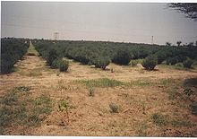
Jojoba plantations, such as those shown, have played a role in combating edge effects of desertification in the Thar Desert, India.
Techniques and countermeasures exist for mitigating or reversing the
effects of desertification, and some possess varying levels of
difficulty. For some, there are numerous barriers to their
implementation. Yet for others, the solution simply requires the
exercise of human reason.
One proposed barrier is that the costs of adopting sustainable
agricultural practices sometimes exceed the benefits for individual
farmers, even while they are socially and environmentally beneficial. Another issue is a lack of political will, and lack of funding to support land reclamation and anti-desertification programs.
Desertification is recognized as a major threat to biodiversity. Some countries have developed Biodiversity Action Plans to counter its effects, particularly in relation to the protection of endangered flora and fauna.
Reforestation gets at one of the root causes of desertification and is not just a treatment of the symptoms. Environmental organizations work in places where deforestation and desertification are contributing to extreme poverty.
There they focus primarily on educating the local population about the
dangers of deforestation and sometimes employ them to grow seedlings,
which they transfer to severely deforested areas during the rainy
season. The Food and Agriculture Organization of the United Nations launched the FAO Drylands Restoration Initiative in 2012 to draw together knowledge and experience on dryland restoration.
In 2015, FAO published global guidelines for the restoration of
degraded forests and landscapes in drylands, in collaboration with the
Turkish Ministry of Forestry and Water Affairs and the Turkish
Cooperation and Coordination Agency.
The Green Wall of China is a high-profile example of one method that has been finding success in this battle with desertification..
This wall is a much larger-scale version of what American farmers did
in the 1930s to stop the great Midwest dust bowl. This plan was proposed
in the late 1970s, and has become a major ecological engineering
project that is not predicted to end until the year 2055. According to
Chinese reports, there have been nearly 66 billion trees planted in
China's great green wall.
Due to the success that China has been finding in stopping the spread of
desertification, plans are currently be made in Africa to start a
"wall" along the borders of the Sahara desert as well to be financed by
the United Nations Global Environment Facility trust.
Techniques focus on two aspects: provisioning of water, and
fixation and hyper-fertilizing soil. Fixating the soil is often done
through the use of shelter belts, woodlots and windbreaks. Windbreaks are made from trees and bushes and are used to reduce soil erosion and evapotranspiration. They were widely encouraged by development agencies from the middle of the 1980s in the Sahel area of Africa.
Some soils (for example, clay), due to lack of water can become consolidated rather than porous (as in the case of sandy soils). Some techniques as zaï or tillage are then used to still allow the planting of crops.
Waffle gardens can also help as they can provide protection of the
plants against wind/sandblasting, and increase the hours of shade
falling on the plant.
Another technique that is useful is contour trenching.
This involves the digging of 150 m long, 1 m deep trenches in the soil.
The trenches are made parallel to the height lines of the landscape,
preventing the water from flowing within the trenches and causing
erosion. Stone walls are placed around the trenches to prevent the
trenches from closing up again. The method was invented by Peter
Westerveld.
Enriching of the soil and restoration of its fertility is often done by plants. Of these, leguminous plants which extract nitrogen from the air and fix it in the soil, and food crops/trees as grains, barley, beans and dates are the most important. Sand fences can also be used to control drifting of soil and sand erosion.
Some research centra (such as Bel-Air Research Center
IRD/ISRA/UCAD) are also experimenting with the inoculation of tree
species with mycorrhiza
in arid zones. The mycorrhiza are basically fungi attaching themselves
to the roots of the plants. They hereby create a symbiotic relation with
the trees, increasing the surface area of the tree's roots greatly
(allowing the tree to gather much more nutrients from the soil).
As there are many different types of deserts, there are also
different types of desert reclamation methodologies. An example for this
is the salt flats in the Rub' al Khali desert in Saudi Arabia.
These salt flats are one of the most promising desert areas for
seawater agriculture and could be revitalized without the use of
freshwater or much energy.
Farmer-managed natural regeneration
(FMNR) is another technique that has produced successful results for
desert reclamation. Since 1980, this method to reforest degraded
landscape has been applied with some success in Niger. This simple and
low-cost method has enabled farmers to regenerate some 30,000 square
kilometers in Niger. The process involves enabling native sprouting tree
growth through selective pruning of shrub shoots. The residue from
pruned trees can be used to provide mulching for fields thus increasing
soil water retention and reducing evaporation. Additionally, properly
spaced and pruned trees can increase crop yields. The Humbo Assisted
Regeneration Project which uses FMNR techniques in Ethiopia has received
money from The World Bank’s BioCarbon Fund, which supports projects
that sequester or conserve carbon in forests or agricultural ecosystems.
Managed grazing
Restoring grasslands store CO2
from the air as plant material. Grazing livestock, usually not left to
wander, would eat the grass and would minimize any grass growth while
grass left alone would eventually grow to cover its own growing buds,
preventing them from photosynthesizing and killing the plant.
A method proposed to restore grasslands uses fences with many small
paddocks and moving herds from one paddock to another after a day or two
in order to mimic natural grazers and allowing the grass to grow
optimally.
It is estimated that increasing the carbon content of the soils in the
world’s 3.5 billion hectares of agricultural grassland would offset
nearly 12 years of CO2 emissions. Allan Savory, as part of holistic management,
claims that while large herds are often blamed for desertification,
prehistoric lands used to support large or larger herds and areas where
herds were removed in the United States are still desertifying; range scientists have however not been able to experimentally confirm his claims.


