Search This Blog

Tuesday, April 28, 2020

Chesapeake Bay

From Wikipedia, the free encyclopedia
 
Chesapeake Bay
Chesapeakelandsat.jpeg
The Chesapeake Bay – Landsat photo
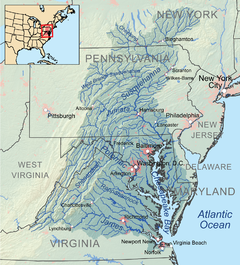
Chesapeakewatershedmap.png
Chesapeake Bay Watershed
LocationMaryland, Virginia
Coordinates37.8°N 76.1°WCoordinates: 37.8°N 76.1°W
TypeEstuary
EtymologyChesepiooc, Algonquian for village "at a big river"
Primary inflowsSusquehanna River mouth
east of Havre de Grace, MD
River sourcesPatapsco River, Patuxent River, Potomac River, Rappahannock River, York River, James River, Chester River, Choptank River, Nanticoke River, Pocomoke River
Primary outflowsAtlantic Ocean
north of Virginia Beach, VA
36°59′45″N 75°57′34″W
Catchment area64,299 sq mi (166,530 km2)

Max. length200 mi (320 km)
Max. width30 mi (48 km)
Surface area4,479 sq mi (11,600 km2)
Average depth21 ft (6.4 m)

References
Official nameChesapeake Bay Estuarine Complex
Designated4 June 1987
Reference no.375

The Chesapeake Bay (/ˈɛsəpk/ CHESS-ə-peek) is an estuary in the U.S. states of Maryland and Virginia. The Bay is located in the Mid-Atlantic region and is primarily separated from the Atlantic Ocean by the Delmarva Peninsula with its mouth located between Cape Henry and Cape Charles. With its northern portion in Maryland and the southern part in Virginia, the Chesapeake Bay is a very important feature for the ecology and economy of those two states, as well as others. More than 150 major rivers and streams flow into the Bay's 64,299-square-mile (166,534 km2) drainage basin, which covers parts of six states (New York, Pennsylvania, Delaware, Maryland, Virginia and West Virginia) and all of Washington, D.C.
 
The Bay is approximately 200 miles (320 km) long from its northern headwaters in the Susquehanna River to its outlet in the Atlantic Ocean. It is 2.8 miles (4.5 km) wide at its narrowest (between Kent County's Plum Point near Newtown and the Harford County shore near Romney Creek) and 30 miles (48 km) at its widest (just south of the mouth of the Potomac River). Total shoreline including tributaries is 11,684 miles (18,804 km), circumnavigating a surface area of 4,479 square miles (11,601 km2). Average depth is 21 feet (6.4 m), reaching a maximum of 174 feet (53 m). The Bay is spanned twice, in Maryland by the Chesapeake Bay Bridge from Sandy Point (near Annapolis) to Kent Island and in Virginia by the Chesapeake Bay Bridge-Tunnel connecting Virginia Beach to Cape Charles. Known for both its beauty and bounty, the Bay has become "emptier", with fewer crabs, oysters and watermen in past years. Recent restoration efforts begun in the 1990s have been ongoing and show potential for growth of the native oyster population. The health of the Chesapeake Bay improved in 2015, marking three years of gains over the past four years, according to a new report by the University of Maryland.

Etymology

The word Chesepiooc is an Algonquian word referring to a village 'at a big river'. It is the seventh oldest surviving English place-name in the United States, first applied as Chesepiook by explorers heading north from the Roanoke Colony into a Chesapeake tributary in 1585 or 1586. The name may also refer to the Chesapeake people or the Chesepian, a Native American tribe who inhabited the area now known as South Hampton Roads in the U.S. state of Virginia. They occupied an area that is now the Norfolk, Portsmouth, Chesapeake, and Virginia Beach areas. In 2005, Algonquian linguist Blair Rudes "helped to dispel one of the area's most widely held beliefs: that 'Chesapeake' means something like 'great shellfish bay'. It does not, Rudes said. The name might actually have meant something like 'great water', or it might have just referred to a village location at the Bay's mouth." In addition, the name is almost always prefixed by the in usage by local residents: The Chesapeake, The Chesapeake Bay and The Bay.

Physical geography

Geology and formation

The Chesapeake Bay is an estuary to the North Atlantic, lying between the Delmarva Peninsula to the east and the North American mainland to the west. It is the ria, or drowned valley, of the Susquehanna River, meaning that it was the alluvial plain where the river flowed when the sea level was lower. It is not a fjord, because the Laurentide Ice Sheet never reached as far south as the northernmost point on the Bay. North of Baltimore, the western shore borders the hilly Piedmont region of Maryland; south of the city the Bay lies within the state's low-lying coastal plain, with sedimentary cliffs to the west, and flat islands, winding creeks and marshes to the east. The large rivers entering the Bay from the west have broad mouths and are extensions of the main ria for miles up the course of each river.

The Bay's geology, its present form, and its very location were created by a bolide impact event at the end of the Eocene (about 35.5 million years ago), forming the Chesapeake Bay impact crater and much later the Susquehanna River valley. The Bay was formed starting about 10,000 years ago when rising sea levels at the end of the last ice age flooded the Susquehanna River valley. Parts of the Bay, especially the Calvert County, Maryland, coastline, are lined by cliffs composed of deposits from receding waters millions of years ago. These cliffs, generally known as Calvert Cliffs, are famous for their fossils, especially fossilized shark teeth, which are commonly found washed up on the beaches next to the cliffs. Scientists' Cliffs is a beach community in Calvert County named for the desire to create a retreat for scientists when the community was founded in 1935.

Hydrology

View of the Eastern Bay in Maryland at sunset
 
The Chesapeake Bay Bridge, near Annapolis, Maryland
 
Much of the Bay is shallow. At the point where the Susquehanna River flows into the Bay, the average depth is 30 feet (9 m), although this soon diminishes to an average of 10 feet (3 m) southeast of the city of Havre de Grace, Maryland, to about 35 feet (11 m) just north of Annapolis. On average, the depth of the Bay is 21 feet (6.4 m), including tributaries; over 24 percent of the Bay is less than 6 ft (2 m) deep.

Because the Bay is an estuary, it has fresh water, salt water and brackish water. Brackish water has three salinity zones: oligohaline, mesohaline, and polyhaline. The freshwater zone runs from the mouth of the Susquehanna River to north Baltimore. The oligohaline zone has very little salt. Salinity varies from 0.5 ppt (parts per thousand) to 10 ppt, and freshwater species can survive there. The north end of the oligohaline zone is north Baltimore and the south end is the Chesapeake Bay Bridge. The mesohaline zone has a medium amount of salt and runs from the Bay Bridge to the mouth of the Rappahannock River. Salinity there ranges from 10.7 ppt to 18 ppt. The polyhaline zone is the saltiest zone, and some of the water can be as salty as sea water. It runs from the mouth of the Rappahannock River to the mouth of the Bay. The salinity ranges from 18.7 ppt to 36 ppt. (36 ppt is as salty as the ocean.)

The climate of the area surrounding the Bay is primarily humid subtropical, with hot, very humid summers and cold to mild winters. Only the area around the mouth of the Susquehanna River is continental in nature, and the mouth of the Susquehanna River and the Susquehanna flats often freeze in winter. It is rare for the surface of the Bay to freeze in winter, something that happened most recently in the winter of 1976–77.

The largest rivers flowing directly into the Bay, from north to south, are:
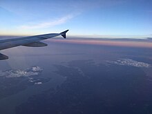
The Bay viewed from a plane

Flora and fauna

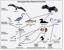
Food chain diagram for waterbirds of the Chesapeake Bay
 
The Chesapeake Bay is home to numerous fauna that either migrate to the Bay at some point during the year or live there year-round. There are over 300 species of fish and numerous shellfish and crab species. Some of these include the Atlantic menhaden, striped bass, American eel, eastern oyster, and the blue crab.

Birds include ospreys, great blue herons, bald eagles, and peregrine falcons, the last two of which were threatened by DDT; their numbers plummeted but have risen in recent years. The piping plover is a near threatened species that inhabits the wetlands.

Larger fish such as Atlantic sturgeon, varieties of sharks, and stingrays visit the Chesapeake Bay. The waters of the Chesapeake Bay have been regarded one of the most important nursery areas for sharks along the east coast. Megafaunas such as bull sharks, tiger sharks, scalloped hammerhead sharks, and basking sharks and manta rays are also known to visit.

Bottlenose dolphins are known to live seasonally/yearly in the Bay. There have been unconfirmed sightings of humpback whales in recent years. Endangered North Atlantic right whale and fin, and minke and sei whales have also been sighted within and in the vicinity of the Bay.

Although the Bay is farther north than its typical habitat range, a male manatee visited the Bay several times between 1994 and 2011. The manatee, recognizable due to distinct markings on its body, was nicknamed "Chessie" after a legendary sea monster that was allegedly sighted in the Bay during the 20th century. The same manatee has been spotted as far north as Rhode Island, and was the first manatee known to travel so far north. Other manatees are occasionally seen in the Bay and its tributaries, which contain sea grasses that are part of the manatee's diet.

Loggerhead turtles are known to visit the Bay.

The Chesapeake Bay is also home to a diverse flora, both land and aquatic. Common submerged aquatic vegetation includes eelgrass and widgeon grass. A report in 2011 suggested that information on underwater grasses would be released, because "submerged grasses provide food and habitat for a number of species, adding oxygen to the water and improving water clarity." Other vegetation that makes its home in other parts of the Bay are wild rice, various trees like the red maple, loblolly pine and bald cypress, and spartina grass and phragmites. Invasive plants have taken a significant foothold in the Bay; plants such as Brazilian waterweed, native to South America, have spread to most continents with the help of aquarium owners, who often dump the contents of their aquariums into nearby lakes and streams. It is highly invasive, and has the potential to flourish in the low-salinity tidal waters of the Chesapeake Bay. Dense stands of Brazilian waterweed can restrict water movement, trap sediment and affect water quality. Various local K-12 schools in the Maryland and Virginia region often have programs that cultivate native bay grasses and plant them in the Bay.

History

European exploration and settlement

Revised map of John White's original by Theodore DeBry. In this 1590 version, the Chesapeake Bay appears named for the first time.
 
Later (1630) version of the 1612 map by Captain John Smith during his exploration of the Chesapeake. The map is oriented with west at top.
 
In 1524, Italian explorer Giovanni da Verrazzano, (1485–1528), in service of the French crown, (famous for sailing through and thereafter naming the entrance to New York Bay as the "Verrazzano Narrows", including now in the 20th century, a suspension bridge also named for him) sailed past the Chesapeake, but did not enter the Bay. Spanish explorer Lucas Vásquez de Ayllón sent an expedition out from Hispaniola in 1525 that reached the mouths of the Chesapeake and Delaware Bays. It may have been the first European expedition to explore parts of the Chesapeake Bay, which the Spaniards called "Bahía de Santa María" ("Bay of St. Mary") or "Bahía de Madre de Dios."("Bay of the Mother of God") De Ayllón established a short-lived Spanish mission settlement, San Miguel de Gualdape, in 1526 along the Atlantic coast. Many scholars doubt the assertion that it was as far north as the Chesapeake; most place it in present-day Georgia's Sapelo Island. In 1573, Pedro Menéndez de Márquez, the governor of Spanish Florida, conducted further exploration of the Chesapeake. In 1570, Spanish Jesuits established the short-lived Ajacan Mission on one of the Chesapeake tributaries in present-day Virginia.

The arrival of English colonists under Sir Walter Raleigh and Humphrey Gilbert in the late 16th century to found a colony, later settled at Roanoke Island (off the present-day coast of North Carolina) for the Virginia Company, marked the first time that the English approached the gates to the Chesapeake Bay between the capes of Cape Charles and Cape Henry. Three decades later, in 1607, Europeans again entered the Bay. Captain John Smith of England explored and mapped the Bay between 1607 and 1609, resulting in the publication in 1612 back in the British Isles of "A Map of Virginia". Smith wrote in his journal: "Heaven and earth have never agreed better to frame a place for man's habitation." The new laying out of the "Captain John Smith Chesapeake National Historic Trail", the United States' first designated "all-water" National Historic Trail, was created in July 2006, by the National Park Service of the U.S. Department of the Interior following the route of Smith's historic 17th-century voyage. Because of economic hardships and civil strife in the "Mother Land", there was a mass migration of southern English Cavaliers and their servants to the Chesapeake Bay region between 1640 and 1675, to both of the new colonies of the Province of Virginia and the Province of Maryland.

American Revolution to the present

The Chesapeake Bay was the site of the Battle of the Chesapeake (also known as the "Battle of the Capes", Cape Charles and Cape Henry) in 1781, during which the French fleet defeated the Royal Navy in the decisive naval battle of the American Revolutionary War. The British defeat enabled General George Washington and his French allied armies under Comte de Rochambeau to march down from New York and bottle up the rampaging southern British Army of Lord Cornwallis from the North and South Carolinas at the siege of Battle of Yorktown in Yorktown, Virginia. Their marching route from Newport, Rhode Island through Connecticut, New York State, Pennsylvania, New Jersey and Delaware to the "Head of Elk" by the Susquehanna River along the shores and also partially sailing down the Bay to Virginia. It is also the subject of a designated National Historic Trail under the National Park Service as the Washington-Rochambeau Revolutionary Route.

The Bay would again see conflict during War of 1812. During the year of 1813, from their base on Tangier Island, British naval forces under the command of Admiral George Cockburn raided and plundered several towns on the shores of the Chesapeake, treating the Bay as if it were a "British Lake". The Chesapeake Bay Flotilla, a fleet of shallow-draft armed barges under the command of U.S. Navy Commodore Joshua Barney, was assembled to stall British shore raids and attacks. After months of harassment by Barney, the British landed on the west side of the Patuxent at Benedict, Maryland, the Chesapeake Flotilla was scuttled, and the British trekked overland to burn the U.S. Capitol in August 1814. A few days later in a "pincer attack", they also sailed up the Potomac River to attack Fort Washington below the National Capital and demanded a ransom from the nearby port town of Alexandria, Virginia.

There were so-called "Oyster Wars" in the late 19th and early 20th centuries. Until the mid-20th century, oyster harvesting rivaled the crab industry among Chesapeake watermen, a dwindling breed whose skipjacks and other workboats were supplanted by recreational craft in the latter part of the century.

In the 1960s, the Calvert Cliffs Nuclear Power Plant on the historic Calvert Cliffs in Calvert County on the Western Shore of Maryland began using water from the Bay to cool its reactor.

Navigation

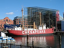
Lighthouses and lightships such as Chesapeake have helped guide ships into the Bay.
 
The Chesapeake Bay forms a link in the Intracoastal Waterway, of the bays, sounds and inlets between the off-shore barrier islands and the coastal mainland along the Atlantic coast connecting the Chesapeake and Delaware Canal (linking the Bay to the north and the Delaware River) with the Albemarle and Chesapeake Canal (linking the Bay, to the south, via the Elizabeth River, by the cities of Norfolk and Portsmouth to the Albemarle Sound and Pamlico Sound in North Carolina and further to the Sea Islands of Georgia). A busy shipping channel (dredged by the U.S. Army Corps of Engineers since the 1850s) runs the length of the Bay, is an important transit route for large vessels entering or leaving the Port of Baltimore, and further north through the Chesapeake and Delaware Canal to the ports of Wilmington and Philadelphia on the Delaware River

During the later half of the 19th century and first half of the 20th century, the Bay was plied by passenger steamships and packet boat lines connecting the various cities on it, notably the Baltimore Steam Packet Company ("Old Bay Line"). 

In the later 20th century, a series of road crossings were built. One, the Chesapeake Bay Bridge (also known as the Governor William Preston Lane, Jr. Memorial Bridge) between the state capital of Annapolis, Maryland and Matapeake on the Eastern Shore, crossing Kent Island, was constructed 1949–1952. A second, parallel, span was added in 1973. The Chesapeake Bay Bridge-Tunnel, connecting Virginia's Eastern Shore with its mainland (at the metropolitan areas of Virginia Beach, Norfolk, Portsmouth, and Chesapeake), is approximately 20 miles (32 km) long; it has trestle bridges as well as two stretches of two-mile-long (3.2 km) tunnels that allow unimpeded shipping; the bridge is supported by four 5.25-acre (21,200 m2) man-made islands. The Chesapeake Bay Bridge-Tunnel was opened for two lanes in 1964 and four lanes in 1999.

Tides

Example Chesapeake Bay tides from Baltimore and the Chesapeake Bay Bridge Tunnel for quarter and full moons during June 2013
 
Tides in the Chesapeake Bay exhibit an interesting and unique behavior due to the nature of the topography (both horizontal and vertical shape), wind driven circulation, and how the Bay interacts with oceanic tides. Research into the peculiar behavior of tides both at the northern and southern extents of the Bay began in the late 1970s. One study noted sea level fluctuations at periods of 5 days, driven by sea level changes at the Bay's mouth on the Atlantic coast and local lateral winds, and 2.5 days, caused by resonant oscillations driven by local longitudinal winds, while another study later found that the geometry of the Bay permits for a resonant period of 1.46 days.

A good example of how the different Chesapeake Bay sites experience different tides can be seen in the tidal predictions published by the National Oceanographic and Atmospheric Administration (NOAA) (see figure at right). 

At the Chesapeake Bay Bridge Tunnel (CBBT) site, which lies at the southernmost point of the Bay where it meets the Atlantic Ocean near Norfolk, Virginia, and the capes of Charles and Henry, there is a distinct semi-diurnal tide throughout the lunar month, with small amplitude modulations during spring (new/full moon) vs. neap (one/three quarter moon) tidal periods. The main forcing of the CBBT tides are typical, semi-diurnal ocean tides that the East Coast of the United States experiences.
Baltimore, in the northern portion of the Bay, experiences a noticeable modulation to form its mixed tidal nature during spring vs. neap tides. Spring tides, when the sun-earth-moon system forms a line, cause the largest tidal amplitudes during lunar monthly tidal variations. In contrast, neap tides, when the sun-earth-moon system forms a right angle, are muted, and in a semi-diurnal tidal system (such as that seen at the CBBT site) this can be seen as a lowest intertidal range. 

Two interesting points that arise from comparing these two sites at opposite ends of the Bay are their tidal characteristics - semi-diurnal tide for CBBT and mixed tide for Baltimore (due to resonance in the Bay) - and the differences in amplitude (due to dissipation in the Bay).

Economy

Fishing industry


The Bay is mostly known for its seafood production, especially blue crabs, clams and oysters. In the middle of the 20th century, the Bay supported 9,000 full-time watermen, according to one account. Today, the body of water is less productive than it used to be because of runoff from urban areas (mostly on the Western Shore) and farms (especially on the Eastern Shore and in the Susquehanna River watershed), over-harvesting, and invasion of foreign species.

The plentiful oyster harvests led to the development of the skipjack, the state boat of Maryland, which is the only remaining working boat type in the United States still under sail power. Other characteristic bay-area workboats include sail-powered boats such as the log canoe, the pungy, the bugeye, and the motorized Chesapeake Bay deadrise, the state boat of Virginia.

In contrast to harvesting wild oysters, oyster farming is a growing industry for the Bay to help maintain the estuary's productivity as well as a natural effort for filtering impurities such as excess nutrients from the water in an effort to reduce the effects of man-made pollution. The Chesapeake Bay Program is using oysters to reduce the amount of nitrogen compounds entering the Chesapeake Bay.

Oysters are hermaphroditic and will change gender at least once during their lifetime, often starting as male and ending as female; there are numerous ways to cook and eat them, as well as recipes and sauces to accompany oyster dishes. One account:
The Chesapeake oyster – sometimes called Chesapeake white gold – has a flavor and texture that begs connoisseurs to come back and shuck just a few more.
— Kendra Bailey Morris, NPR, 2007
The Bay is famous for its rockfish, a regional name for striped bass. Once on the verge of extinction, rockfish have made a significant comeback because of legislative action that put a moratorium on rockfishing, which allowed the species to re-populate. Rockfish can now be fished in strictly controlled and limited quantities.

Tourism and recreation

The Thomas Point Shoal Light in Maryland
 
The Chesapeake Bay is a main feature for tourists who visit Maryland and Virginia each year. Fishing, crabbing, swimming, boating, kayaking, and sailing are extremely popular activities enjoyed on the waters of the Chesapeake Bay. As a result, tourism has a notable impact on Maryland's economy. One report suggested that Annapolis was an appealing spot for families, water sports and boating. Commentator Terry Smith spoke about the Bay's beauty:
The water is glassy, smooth and gorgeous, his wake white against the deep blue. That's the problem with the Chesapeake. It's so damned beautiful.
One account suggested how the Chesapeake attracts people:
You see them everywhere on Maryland's Eastern Shore, the weekend sailors. They are unmistakable with their deep tans, their baggy shorts, their frayed polo shirts, their Top-Siders worn without socks. Some may not even own their own boats, much less win regattas, but they are inexorably drawn to the Chesapeake Bay ... I planned to spend my days boating, eating as many Chesapeake Bay blue crabs as possible and making a little study of Eastern Shore locals. For city folk like me, they're interesting, even exotic –the weather-beaten crabbers and oystermen called "watermen," gentlemen-farmers and sharecroppers, boat builders, antiques dealers – all of whom sound like Southerners with mouthfuls of marbles when they talk. — Susan Spano, Los Angeles Times, 2008

Cuisine

In colonial times simple cooking techniques were used to create one pot meals like ham and potato casserole, clam chowder, or stews with common ingredients like oysters, chicken or venison. When John Smith landed in Chesapeake in 1608 he wrote: "The fish were so thick, we attempted to catch them with frying pans". Common regional ingredients in the local cuisine of Chesapeake included terrapins, smoked hams, blue crab, shellfish, local fish, game meats and various species of waterfowl. Blue crab continues to be an especially popular regional specialty. 

Environmental problems

Pollution and runoff

Tidal wetlands of the Chesapeake Bay
 
Dissolved oxygen levels required by various species
 
Sediment sources in the Chesapeake Bay
 
Environmental Protection Agency photo of dead menhaden floating in the bay in June 1973
 
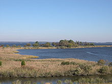
Reeds along the bay
 
In the 1970s, the Chesapeake Bay was found to contain one of the planet's first identified marine dead zones, where waters were so depleted of oxygen that they were unable to support life, resulting in massive fish kills. Today the Bay's dead zones are estimated to kill 75,000 tons of bottom-dwelling clams and worms each year, weakening the base of the estuary's food chain and robbing the blue crab in particular of a primary food source. Crabs are sometimes observed to amass on shore to escape pockets of oxygen-poor water, a behavior known as a "crab jubilee". Hypoxia results in part from large algal blooms, which are nourished by the runoff of residential, farm and industrial waste throughout the watershed. One report in 2010 criticized Amish farmers for having cows that "generate heaps of manure that easily washes into streams and flows onward into the Chesapeake Bay".

U.S. Navy sailors looking for trash during "Clean The Bay Day" in 2008
 
The runoff and pollution have many components that help contribute to the algal bloom, which is mainly fed by phosphorus and nitrogen. This algae prevents sunlight from reaching the bottom of the Bay while alive and deoxygenates the Bay's water when it dies and rots. The erosion and runoff of sediment into the Bay, exacerbated by devegetation, construction and the prevalence of pavement in urban and suburban areas, also blocks vital sunlight. The resulting loss of aquatic vegetation has depleted the habitat for much of the Bay's animal life. Beds of eelgrass, the dominant variety in the southern Chesapeake Bay, have shrunk by more than half there since the early 1970s. Overharvesting, pollution, sedimentation and disease have turned much of the Bay's bottom into a muddy wasteland.

One particularly harmful source of toxicity is Pfiesteria piscicida, which can affect both fish and humans. Pfiesteria caused a small regional panic in the late 1990s when a series of large blooms started killing large numbers of fish while giving swimmers mysterious rashes; nutrient runoff from chicken farms was blamed for the growth.

The Bay has improved slightly in terms of the overall health of its ecosystem, earning a rating of 31 out of 100 in 2010, up from 28 in 2008. An estimate in 2006 from a "blue ribbon panel" said cleanup costs would be $15 billion. Compounding the problem is that 100,000 new residents move to the area each year. A report in 2008 in the Washington Post suggested that government administrators had overstated progress on cleanup efforts as a way to "preserve the flow of federal and state money to the project." In January 2011, there were reports that millions of fish had died, but officials suggested it was probably the result of extremely cold weather.

Depletion of oysters

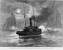
Oyster boats at war off the Maryland shore (1886 wood engraving). Regulation of the oyster beds in Virginia and Maryland has existed since the 19th century.
 
While the Bay's salinity is ideal for oysters and the oyster fishery was at one time the Bay's most commercially viable, the population has in the last fifty years been devastated. Maryland once had roughly 200,000 acres (810 km2) of oyster reefs. Today it has about 36,000. It has been estimated that in pre-colonial times, oysters could filter the entirety of the Bay in about 3.3 days; by 1988 this time had increased to 325 days. The harvest's gross value decreased 88% from 1982 to 2007. One report suggested the Bay had fewer oysters in 2008 than 25 years earlier.

A cluster of oysters grown in a sanctuary
 
The primary problem is overharvesting. Lax government regulations allow anyone with a license to remove oysters from state-owned beds, and although limits are set, they are not strongly enforced. The overharvesting of oysters has made it difficult for them to reproduce, which requires close proximity to one another. A second cause for the oyster depletion is that the drastic increase in human population caused a sharp increase in pollution flowing into the Bay. The Bay's oyster industry has also suffered from two diseases: MSX and Dermo.

The depletion of oysters has had a particularly harmful effect on the quality of the Bay. Oysters serve as natural water filters, and their decline has further reduced the water quality of the Bay. Water that was once clear for meters is now so turbid that a wader may lose sight of his feet while his knees are still dry. 

Efforts of federal, state and local governments, working in partnership through the Chesapeake Bay Program, and the Chesapeake Bay Foundation and other nonprofit environmental groups, to restore or at least maintain the current water quality have had mixed results. One particular obstacle to cleaning up the Bay is that much of the polluting substances arise far upstream in tributaries lying within states far removed from the Bay. Despite the state of Maryland spending over $100 million to restore the Bay, conditions have continued to grow worse. Twenty years ago, the Bay supported over 6,000 oystermen. There are now fewer than 500.

Efforts to repopulate the Bay via hatcheries have been carried out by a group called the Oyster Recovery Partnership, with some success. They recently placed 6 million oysters on eight acres (32,000 m2) of the Trent Hall sanctuary. Scientists from the Virginia Institute of Marine Science at the College of William & Mary claim that experimental reefs created in 2004 now house 180 million native oysters, Crassostrea virginica, which is far fewer than the billions that once existed.

Publications

There are several magazines and publications that cover topics directly related to the Chesapeake Bay and life and tourism within the Bay region. 

The Capital, a newspaper based in Annapolis, reports about news pertaining to the Western Shore of Maryland and the Annapolis area. Chesapeake Bay Magazine and PropTalk focus on powerboating, while SpinSheet focuses on sailing.

Cultural depictions

In literature

In film

  • The Bay, a 2012 found footage-style eco-horror movie about a pandemic due to deadly pollution from chicken factory farm run-off and mutant isopods and aquatic parasites able to infect humans.

Other media

Singer and songwriter Tom Wisner recorded several albums, often about the Chesapeake Bay. The Boston Globe wrote that Wisner "always tried to capture the voice of the water and the sky, of the rocks and the trees, of the fish and the birds, of the gods of nature he believed still watched over it all." He was known as the Bard of the Chesapeake Bay. 

The 1976 hit "Moonlight Feels Right" by Starbuck refers to Chesapeake Bay: "I'll take you on a trip beside the ocean / And drop the top at Chesapeake Bay."

Caribou Inuit

From Wikipedia, the free encyclopedia
 
Caribou Inuit
Total population
3,000
Regions with significant populations
Nunavut
Languages
Inuktitut
Religion
Christianity, Inuit religion
Related ethnic groups
Copper Inuit

Caribou Inuit (Inuit: Kivallirmiut ), barren-ground caribou hunters, are bands of inland Inuit who lived west of Hudson Bay in Keewatin Region, Northwest Territories, now the Kivalliq Region of present-day Nunavut between 61° and 65° N and 90° and 102° W in Northern Canada. They were originally named "Caribou Eskimo" by the Danish Fifth Thule Expedition of 1921-4 led by Knud Rasmussen. Caribou Inuit are the southernmost subgroup of the Central Inuit.

Approximate location of Caribou Inuit bands at the end of the 19th century

Bands

Ahialmiut
Ahialmiut relied on caribou year-round. They spent summers on the Qamanirjuaq calving grounds at Qamanirjuaq Lake ("huge lake adjoining a river at both ends") and spent winters following the herd to the north.
Akilinirmiut
Akilinirmiut were located in the Thelon River area by the Akiliniq Hills (A-ki, meaning "the other side") to the north of Beverly Lake and also visible above Aberdeen Lake. Some lived northwest of Baker Lake (Qamani'tuuaq), along with Qairnirmiut and Hauniqturmiut. Many relocated to Aberdeen Lake because of starvation or education opportunities.
Hanningajurmiut
Hanningajurmiut, or Hanningaruqmiut, or Hanningajulinmiut {"the people of the place that lies across"} lived at Garry Lake, south of the Utkuhiksalingmiut. Many Hanningajurmiut starved in 1958 when the caribou bypassed their traditional hunting grounds, but the 31 who survived were relocated to Baker. Most never returned permanently to Garry Lake.
Harvaqtuurmiut
Harvaqtuurmiut were a northern group located in the region of Kazan River, Yathkyed Lake, Kunwak River, Beverly Lake, and Dubawnt River. By the early 1980s, most lived at Baker Lake.
Hauniqtuurmiut
Hauneqtormiut, or Hauniqtuurmiut, or Kangiqliniqmiut, ("dwellers where bones abound") were a smaller band who lived near the coast, south of Qairnirmiuts, around the Wilson River and Ferguson River. By the 1980s, they were absorbed into subgroups at Whale Cove and Rankin Inlet.
Ihalmiut
Ihalmiut ("people from beyond"), or Ahiarmiut ("the out-of-the-way dwellers") were located at the banks of the Kazan River, Ennadai Lake, Little Dubawnt Lake (Kamilikuak), and north of Thlewiaza (Kugjuaq; "Big River"). Relocations in the 1950s included to Henik Lake, Whale Cove, and by the 1980s, most were in Eskimo Point.
Paallirmiut
Paallirmiut ("people of the willow"), or Padlermiut ("people from the Padlei River region"), or Padleimiut were the most populous band. They were located south of the Hauniqtuurmiut and Harvaqtuurmiut bands. Paallirmiut were split into a coast-visiting (Arviat) subgroup who spent the hunting season on the lower Maguse River, and an interior subgroup who stayed year-round in the Yathkyed Lake to Dubawnt Lake area. After Hudson's Bay Company ships discontinued trading the Keewatin coast in 1790, Paallirmiut traveled to Fort Prince of Wales for trade. The Arvia'juaq and Qikiqtaarjuk National Historic Site is the band's historic summer camping site. By the 1980s, most lived in Eskimo Point (Arviat).
Qaernermiut
Qaernermiut ("dwellers of the flat land"), or Qairnirmiut ("bedrock people"), or Kinipetu (Franz Boas, 1901), or Kenepetu, a northern group, were located from the sea coast between Chesterfield Inlet to Rankin Inlet across to their main area around Baker Lake and some even to Beverly Lake. By the early 1980s, most lived at Baker Lake.
Utkuhiksalingmiut
Utkuhiksalingmiut ("people who have cooking pots"), were located in the Chantrey Inlet area around the Back River, near Baker Lake. They made their pots (utkusik) from soapstone of the area, therefore their name. Their dialect is a variant of Natsilingmiutut, spoken by the Netsilik.

Origin

Lacking an early written language, Caribou Inuit pre-history is unclear. There are three main theories:
  1. Caribou Inuit are the descendants of an interior Eskimo culture that spread in Arctic North America and Greenland. (Birket-Smith, 1930; Rasmussen, 1930; Czonka, 1995)
  2. Caribou Inuit are the descendants of Thule people who had migrated from Alaska. (Mathiassen, 1927)
  3. Caribou Inuit were the 17th century descendants of a migratory subgroup of Copper Inuit from the arctic coast. (Taylor, 1972; Burch, 1978) While this is the most current hypothesis, it is still unproven. (Czonka, 1998)

History

Caribou Inuit ancestors originally went back and forth between the Barrenlands to hunt the Beverly and the Qamanirjuaq ("Kaminuriak") caribou herds during seasonal migrations; and the Hudson Bay (Tariurjuaq) for whaling and to fish during the winters. The Chipewyan Sayisi Dene were caribou hunters also, but they stayed inland year-round. Because of waning caribou populations during extended periods, including the 18th century, the Dene moved away from the area, and the Caribou Inuit began to live inland year-round harvesting enough caribou to get through winters without reliance on coastal life.

Regular contact began around 1717 after the establishment of a permanent settlement in Churchill, Manitoba. The contact included access to guns, along with an introduction to trapping and whaling. Christian missionary, Father Alphonse Gasté, made diary notes about peaceful relations between settled Caribou Inuit and migratory Dene that he met along the Kazan River in the late 19th century. Explorer Joseph Tyrrell estimated the "Caribou Eskimo" numbered nearly 2,000 when he led the Geological Survey of Canada's Barren Lands expeditions of 1893 and 1894. Eugene Arima classifies the Hauniqtuurmiut, Ha'vaqtuurmiut, Paallirmiut, and Qairnirmiut as Caribou Inuit "southern, latter" bands: through the end of the 19th century, they were primarily coastal saltwater hunters, but with firearm ammunition from commercial whalers, they were able to live inland year-round hunting caribou without augmenting their diet on sea life. (Arima 1975)

Regular trade dates to the early 20th century and missionaries arrived soon thereafter, developing a written language, challenged by a variety of pronunciations and naming rules. In the Arctic spring of 1922, explorer/anthropologist Kaj Birket-Smith and Rasmussen encountered and reported on the lives of Harvaqtuurmiut and Paallirmiut. Some hunting years were better than others as resident caribou and migratory herds grew or declined, but Caribou Inuit populations dwindled through the decades. Starvation was not uncommon. During a bleak period in the 1920s, some of the Caribou Inuit made their way to Hudson's Bay Company outposts and small, scattered villages on their own. In the early 1950s the Canadian media reported the starvation deaths of 60 Caribou Inuit. The government was slow to act but in 1959 moved the surviving 60, of around the 120 that were alive in 1950, to settlements such as Baker Lake and Eskimo Point. This set off an Arctic settlement push by the Canadian government where those First Nations living in the North were encouraged to abandon their traditional way of life and settle in villages and outposts of the Canadian North. Author/explorer Farley Mowat visited the Ihalmiut in the 1940s and 1950s, writing extensively about the Ihalmiut.

Ethnography

Early 20th Century Inuit parka
 
Caribou Inuit were nomadic and summers were time of relocation to reach different game and to trade. In addition to hunting, they fished in local lakes and rivers (kuuk). Caribou Inuit northern bands from as far away as Dubawnt River travelled on trading trips to Churchill via Thlewiaza River for extra supplies. The nomadic nature made the people and their dogs into strong walkers and sledders who carried loads of implements, bedding, and tents. Kayaks portaged people and baggage in rivers and lakes.

Kayaks were also used for hunting at water crossings during annual migration. Wounded animals were tied together, brought ashore, and killed there to avoid the struggle of dragging dead animals. Every part of the caribou was important. The antlers were used for tools, such as the ulu ("knife") and goggles to prevent snow blindness. The hides were used for footwear and clothing, including the anorak and amauti, using caribou sinew to piece the articles together, and worn in many layers. Mittens were lined with fur, down, and moss. While spring-gathered caribou skins were thin, sleek, and handsome, summer-gathered caribou skins were stronger and warmer. Hides were used also for tents, tools, and containers.

Caribou Inuit lived within a patrilocal social unit. The male elder, the ihumataq ("group leader"), was the centralized authority. There was no other form of authority within subgroups or within the Caribou Inuit in general. Like other Inuit, Caribou Inuit practiced an animist religion, including beliefs that everything had a soul or energy with a disposition or personality. The protector was Pinga, a female figure, the object of taboos, who brings the dead to Adlivun. The supreme force was Hila ("air"), a male figure and the source of misfortune. Christian missionaries established posts in the Barren Lands between 1910 and 1930, converting (siqqitiq) most Inuit from animists to Christians, though some, nonetheless, maintain remnants of their traditional shamanistic beliefs.

Caribou Inuit are Inuktitut speakers. Inuktitut has six dialects, of which Caribou Inuit speak the Kivalliq dialect, and that is further divided into the subdialects, Ahiarmiut, Hauniqturmiut, Paallirmiut, and Qairnirmiut. The Utkuhiksalingmiut's dialect, Utkuhiksalingmiutut, is similar to but distinct from their neighbors' Nattilingmiutut. Like other central Canadian Arctic people, Caribou Inuit participated in nipaquhiit ("games done with sounds or with noises"). The Caribou Inuit genre lacked typical katajjaq ("throat sounds") but added narration missing amongst other Inuit groups.

Modern-day adaptation

Re-settlement
There are several books written on the hardships and the 1950s federal government re-settlement of Caribou Inuit. With re-settlement to coastal communities, the nomadic nuunamiut ("people of the land") ways ended and Caribou Inuit joined tareumiut ("people of the sea"), the maritime Inuit being a more stable group. Even with federal assistance, adapting to displacement in fewer and larger towns proved difficult, resulting in high unemployment, domestic violence, sexual abuse, substance addiction, suicide, and parental neglect.
Language
With the acquisition of English, native language loss is the primary threat to their cultural survival, while neither language is being mastered.
Art
On a positive note, artisan skills evolved and Caribou Inuit, such as Jessie Oonark, are notable for their figurines of animal life. Another Inuit art medium, also considered a game, and also associated with their religious beliefs, involves string figures (ajaraaq/ajaqaat [plural]).
Population
About 3,000 Caribou Inuit exist today, located in Chesterfield Inlet, Rankin Inlet, Whale Cove, Arviat, and Baker Lake.

Trans-cultural diffusion

From Wikipedia, the free encyclopedia
 
In cultural anthropology and cultural geography, cultural diffusion, as conceptualized by Leo Frobenius in his 1897/98 publication Der westafrikanische Kulturkreis, is the spread of cultural items—such as ideas, styles, religions, technologies, languages—between individuals, whether within a single culture or from one culture to another. It is distinct from the diffusion of innovations within a specific culture. Examples of diffusion include the spread of the war chariot and iron smelting in ancient times, and the use of automobiles and Western business suits in the 20th century.

Types

Five major types of cultural diffusion have been defined:
  • Expansion diffusion: an innovation or idea that develops in a source area and remains strong there, while also spreading outward to other areas. This can include hierarchical, stimulus, and contagious diffusion.
  • Relocation diffusion: an idea or innovation that migrates into new areas, leaving behind its origin or source of the cultural trait.
  • Hierarchical diffusion: an idea or innovation that spreads by moving from larger to smaller places, often with little regard to the distance between places, and often influenced by social elites.
  • Contagious diffusion: an idea or innovation that spreads based on person-to-person contact within a given population.
  • Stimulus diffusion: an idea or innovation that spreads based on its attachment to another concept.

Mechanisms

Inter-cultural diffusion can happen in many ways. Migrating populations will carry their culture with them. Ideas can be carried by trans-cultural visitors, such as merchants, explorers, soldiers, diplomats, slaves, and hired artisans. Technology diffusion has often occurred by one society luring skilled scientists or workers by payments or other inducement. Trans-cultural marriages between two neighboring or interspersed cultures have also contributed. Among literate societies, diffusion can occur through letters, books, and, in modern times, through electronic media.
There are three categories of diffusion mechanisms:
  • Direct diffusion occurs when two cultures are very close to each other, resulting in intermarriage, trade, and even warfare. An example of direct diffusion is between the United States and Canada, where the people living on the border of these two countries engage in hockey, which started in Canada, and baseball, which is popular in American culture.
  • Forced diffusion occurs when one culture subjugates (conquers or enslaves) another culture and forces its own customs on the conquered people. An example would be the forced Christianization of the indigenous peoples of the Americas by the Spanish, French, English and Portuguese, or the forced Islamization of West African peoples by the Fula or of the Nuristanis by the Afghans.
  • Indirect diffusion happens when traits are passed from one culture through a middleman to another culture, without the first and final cultures being in direct contact. An example could be the presence of Mexican food in Canada, since a large territory (the United States) lies between.
Direct diffusion was common in ancient times, when small groups of humans lived in adjoining settlements. Indirect diffusion is common in today's world because of the mass media and invention of the Internet. Also of interest is the work of American historian and critic Daniel J. Boorstin in his book The Discoverers, in which he provides an historical perspective on the role of explorers in the diffusion of innovations between civilizations.

Theories

The many models that have been proposed for inter-cultural diffusion are:
  • Migrationism, the spread of cultural ideas by either gradual or sudden population movements
  • Culture circles diffusionism (Kulturkreise)—the theory that cultures originated from a small number of cultures
  • "Kulturkugel" (a German compound meaning "culture bullet", coined by J. P. Mallory), a mechanism suggested by Mallory to model the scale of invasion vs. gradual migration vs. diffusion. According to this model, local continuity of material culture and social organization is stronger than linguistic continuity, so that cultural contact or limited migration regularly leads to linguistic changes without affecting material culture or social organization.
  • Hyperdiffusionism—the theory that all cultures originated from one culture
A concept that has often been mentioned in this regard, which may be framed in the evolutionary diffusionism model, is that of "an idea whose time has come" — whereby a new cultural item appears almost simultaneously and independently in several widely separated places, after certain prerequisite items have diffused across the respective communities. This concept was invoked with regard to the independent development of calculus by Newton and Leibnitz, and the inventions of the airplane and of the electronic computer.

Hyperdiffusionism

Hyperdiffusionists deny that parallel evolution or independent invention took place to any great extent throughout history; they claim that all major inventions and all cultures can be traced back to a single culture.

Early theories of hyperdiffusionism can be traced to ideas about South America being the origin of mankind. Antonio de León Pinelo, a Spaniard who settled in Bolivia, claimed in his book Paraíso en el Nuevo Mundo that the Garden of Eden and the creation of man had occurred in present-day Bolivia and that the rest of the world was populated by migrations from there. Similar ideas were also held by Emeterio Villamil de Rada; in his book La Lengua de Adán he attempted to prove that Aymara was the original language of mankind and that humanity had originated in Sorata in the Bolivian Andes. The first scientific defence of humanity originating in South America came from the Argentine paleontologist Florentino Ameghino in 1880, who published his research in La antigüedad del hombre en el Plata.

The work of Grafton Elliot Smith fomented a revival of hyperdiffusionism in 1911; he asserted that copper–producing knowledge spread from Egypt to the rest of the world along with megalithic culture. Smith claimed that all major inventions had been made by the ancient Egyptians and were carried to the rest of the world by migrants and voyagers. His views became known as "Egyptocentric-Hyperdiffusionism". William James Perry elaborated on Smith's hypothesis by using ethnographic data. Another hyperdiffusionist was Lord Raglan; in his book How Came Civilization (1939) he wrote that instead of Egypt all culture and civilization had come from Mesopotamia. Hyperdiffusionism after this did not entirely disappear, but it was generally abandoned by mainstream academia.

Medieval Europe

Diffusion theory has been advanced as an explanation for the "European miracle", the adoption of technological innovation in medieval Europe which by the 17th century culminated in European technological achievement surpassing the Islamic world and China. Such technological import to medieval Europe include gunpowder, clock mechanisms, shipbuilding, paper and the windmill, however, in each of these cases Europeans not only adopted the technologies, but improved the manufacturing scale, inherent technology, and applications to a point clearly surpassing the evolution of the original invention in its country of origin.

Historians have questioned recently whether Europe really owes the development of such inventions as gunpowder, the compass, the windmill or printing to the Chinese or other cultures.

However historian Peter Frankopan argues that influences, particularly trade, through the middle east & central Asia to China through the silk roads have been overlooked in traditional histories of the "rise of the west". He argues that the renaissance was funded with trade with the east (due to the demise of Byzantium at the hands of Venice and the 4th Crusade), and that the trade allowed ideas and technology to be shared with Europe. But the constant warfare and rivalry in Europe meant there was extreme evolutionary pressure for developing these ideas for military and economic advantage, and a desperate need to use them in expansion.

Disputes

While the concept of diffusion is well accepted in general, conjectures about the existence or the extent of diffusion in some specific contexts have been hotly disputed. An example of such disputes is the proposal by Thor Heyerdahl that similarities between the culture of Polynesia and the pre-Columbian civilizations of the Andes are due to diffusion from the latter to the former—a theory that currently has few supporters among professional anthropologists. Heyerdahl's theory of Polynesian origins has not gained acceptance among anthropologists.

Contributors

Major contributors to inter-cultural diffusion research and theory include:

Pre-modern human migration

From Wikipedia, the free encyclopedia
Paleolithic migration prior to end of the Last Glacial Maximum spread anatomically modern humans throughout Afro-Eurasia and to the Americas. During the Holocene climatic optimum, formerly isolated populations began to move and merge, giving rise to the pre-modern distribution of the world's major language families.

In the wake of the population movements of the Mesolithic came the Neolithic revolution, followed by the Indo-European expansion in Eurasia and the Bantu expansion in Africa.

Population movements of the proto-historical or early historical period include the Migration period, followed by (or connected to) the Slavic, Magyar Norse, Turkic and Mongol expansions of the medieval period.

The last world regions to be permanently settled were the Pacific Islands and the Arctic, reached during the 1st millennium AD.

Since the beginning of the Age of Exploration and the beginning of the Early Modern period and its emerging colonial empires, an accelerated pace of migration on the intercontinental scale became possible.

Prehistory

Neolithic expansions from the 7th to the 5th millennium BC

Neolithic to Chalcolithic

Agriculture is believed to have first been practised around 10,000 BC in the Fertile Crescent (see Jericho). From there, it propagated as a "wave" across Europe, a view supported by Archaeogenetics, reaching northern Europe some 5 millennia ago. 

Some evidence (including a 2016 study by Busby et al.) suggests admixture from an ancient migration from Eurasia into parts of Sub-Saharan Africa. Another study (Ramsay et al. 2018) also shows evidence that ancient Eurasians migrated into Africa and that Eurasian admixture in modern Sub-Saharan Africans ranges from 0% to 50%, varying by region and generally highest (after North Africa) in the Horn of Africa and parts of the Sahel zone.

Bronze Age

Scheme of Indo-European migrations from c. 4000 to 1000 BC according to the Kurgan hypothesis. The purple area corresponds to the assumed Urheimat (Samara culture, Sredny Stog culture). The red area corresponds to the area which may have been settled by Indo-European-speaking peoples up to c. 2500 BC; the orange area to 1000 BC.
 
The proposed Indo-European migration has variously been dated to the end of the Neolithic (Marija Gimbutas: Corded Ware culture, Yamna culture, Kurgan culture), the early Neolithic (Colin Renfrew: Starčevo-Körös, Linearbandkeramic) and the late Palaeolithic (Marcel Otte, Paleolithic Continuity Theory).

The speakers of the Proto-Indo-European language are usually believed to have originated to the North of the Black Sea (today Eastern Ukraine and Southern Russia), and from there they gradually migrated into, and spread their language by cultural diffusion to, Anatolia, Europe, and Central Asia Iran and South Asia starting from around the end of the Neolithic period. Other theories, such as that of Colin Renfrew, posit their development much earlier, in Anatolia, and claim that Indo-European languages and culture spread as a result of the agricultural revolution in the early Neolithic.

Relatively little is known about the inhabitants of pre-Indo-European "Old Europe". The Basque language remains from that era, as do the indigenous languages of the Caucasus. The Sami are genetically distinct among the peoples of Europe, but the Sami languages, as part of the Uralic languages, spread into Europe about the same time as the Indo-European languages. However, since that period speakers of other Uralic languages such as the Finns and the Estonians have had more contact with other Europeans, thus today sharing more genes with them than the Sami.

The earliest migrations we can reconstruct from historical sources are those of the 2nd millennium BC. The Proto-Indo-Iranians began their expansion from c. 2000 BC, the Rigveda documenting the presence of early Indo-Aryans in the Punjab from the late 2nd millennium BC, and Iranian tribes being attested in Assyrian sources as in the Iranian plateau from the 9th century BC. In the Late Bronze Age, the Aegean and Anatolia were overrun by moving populations, summarized as the "Sea Peoples", leading to the collapse of the Hittite Empire and ushering in the Iron Age.

Austronesian expansion

Austronesians expansion map

The islands of the Pacific were populated during c. 1600 BC and AD 1000. The Lapita people, who got their name from the archaeological site in Lapita, New Caledonia, where their characteristic pottery was first discovered, came from Austronesia, probably New Guinea, reaching the Solomon Islands, around 1600 BC, and later to Fiji, Samoa and Tonga. By the beginning of the 1st millennium BC, most of Polynesia was a loose web of thriving cultures who settled on the islands' coasts and lived off the sea. By 500 BC Micronesia was completely colonized; the last region of Polynesia to be reached was New Zealand in around 1000.

Celtic expansion in Europe, 6th–3rd century BC

Bantu expansion

The Bantu expansion is the major prehistoric migratory pattern that shaped the ethno-linguistic composition of Sub-Saharan Africa.

The Bantu, a branch of the Niger-Congo phylum, originated in West Africa around the Benue-Cross rivers area in southeastern Nigeria. Beginning in the 2nd millennium BC, they spread to Central Africa, and later, during the 1st millennium BC onward southeastern, spreading pastoralism and agriculture. During the 1st millennium AD, they populated Southern African. In the process, the Bantu languages displaced the Khoisan languages indigenous to Central and Southern Africa.

Arctic peoples

The final region to be permanently settled by humans was the Arctic, reached by the Dorset culture during about 500 BC to AD 1500. The Inuit are the descendants of the Thule culture, which emerged from western Alaska around AD 1000 and gradually displaced the Dorset culture.

Proto-historical and early historical migration

Map of Phoenician (in yellow) and Greek colonies (in red) around 8th to 6th century BC
 
Map showing the southward migration of the Han Chinese (in blue)
 
The German term Landnahme ("land-taking") is sometimes used in historiography for a migration event associated with a founding legend, e.g. of the conquest of Canaan in the Hebrew Bible, the Indo-Aryan migration and expansion within India alluded to in the Rigveda, the invasion traditions in the Irish Mythological Cycle, accounting for how the Gaels came to Ireland the arrival of the Franks in Austrasia during the Migration period, the Anglo-Saxon invasion of Britain, the settlement of Iceland in the Viking Age, the Slavic migrations, the Hungarian conquest , etc.

Iron Age

The Dorian invasion of Greece led to the Greek Dark Ages. The Urartians were displaced by Armenians, and the Cimmerians and the Mushki migrated from the Caucasus into Anatolia. A Thraco-Cimmerian connection links these movements to the Proto-Celtic world of central Europe, leading to the introduction of Iron to Europe and the Celtic expansion to western Europe and the British Isles around 500 BC.

Migration period

2nd to 5th century migrations. See also map of the world in 820.
 
Migration of Slavic peoples in the 5th to 10th centuries.
 
Western historians refer to the period of migrations that separated Antiquity from the Middle Ages in Europe as the Great Migrations or as the Migrations Period. This period is further divided into two phases.

The first phase, from 300 to 500, saw the movement of Germanic, Sarmatian and Hunnic tribes and ended with the settlement of these peoples in the areas of the former Western Roman Empire. (See also: Ostrogoths, Visigoths, Burgundians, Suebi, Alamanni, Marcomanni).

The second phase, between 500 and 900, saw Slavic, Turkic and other tribes on the move, re-settling in Eastern Europe and gradually making it predominantly Slavic. Moreover, more Germanic tribes migrated within Europe during this period, including the Lombards (to Italy), and the Angles, Saxons, and Jutes (to the British Isles). See also: Avars, Bulgars, Huns, Arabs, Vikings, Varangians. The last phase of the migrations saw the coming of the Hungarians to the Pannonian plain.

German historians of the 19th century referred to these Germanic migrations as the Völkerwanderung, the migrations of the peoples.

The European migration period is connected with the simultaneous Turkic expansion which at first displaced other peoples towards the west, and by High Medieval times, the Seljuk Turks themselves reached the Mediterranean.

Early medieval period

The medieval period, although often presented as a time of limited human mobility and slow social change in the history of Europe, in fact saw widespread movement of peoples. The Vikings from Scandinavia raided all over Europe from the 8th century and settled in many places, including Normandy, the north of England, Scotland and Ireland (most of whose urban centres were founded by the Vikings). The Normans later conquered the Saxon Kingdom of England, most of Ireland, southern Italy and Sicily

Iberia was invaded by Muslim Arabs, Berbers and Moors in the 8th century, founding new Kingdoms such as al Andalus and bringing with them a wave of settlers from North Africa. The invasion of North Africa by the Banu Hilal, a warlike Arab Bedouin tribe, was a major factor in the linguistic, cultural Arabization of the Maghreb.

Late Middle Ages

Massive migrations of Germans took place into East Central and Eastern Europe, reaching its peak in the 12th to 14th centuries. These Ostsiedlung settlements in part followed territorial gains of the Holy Roman Empire, but areas beyond were settled, too.

At the end of the Middle Ages, the Romani (gypsies) arrived in Europe from the Middle East. They originate in India, probably an offshoot of the Domba people of Northern India who had left for Sassanid Persia around the 5th century.

Early Modern period

Map of Vietnam showing the conquest of the south (the Nam tiến, 1069–1757).

Early Modern Europe

Internal European migration stepped up in the Early Modern Period. In this period, major migration within Europe included the recruiting by monarchs of landless laborers to settle depopulated or uncultivated regions and a series of forced migration caused by religious persecution. Notable examples of this phenomenon include the expulsion of the Jews from Spain in 1492, mass migration of Protestants from the Spanish Netherlands to the Dutch Republic after the 1580s, the expulsion of the Moriscos (descendants of former Muslims) from Spain in 1609, and the expulsion of the Huguenots from France in the 1680s. Since the 14th century, the Serbs started leaving the areas of their medieval Kingdom and Empire that was overrun by the Ottoman Turks and migrated to the north, to the lands of today's Vojvodina (northern Serbia), which was ruled by the Kingdom of Hungary at that time. The Habsburg monarchs of Austria encouraged them to settle on their frontier with the Turks and provide military service by granting them free land and religious toleration. The two greatest migrations took place in 1690 and 1737. Other instances of labour recruitments include the Plantations of Ireland - the settling of Ireland with Protestant colonists from England, Scotland and Wales in the period 1560–1690 and the recruitment of Germans by Catherine the Great of Russia to settle the Volga region in the 18th century.

Colonial empires

European Colonialism from the 16th to the early 20th centuries led to an imposition of a European colonies in many regions of the world, particularly in the Americas, South Asia, Sub-Saharan Africa and Australia, where European languages remain either prevalent or in frequent use as administrative languages. Major human migration before the 18th century was largely state directed. For instance, Spanish emigration to the New World was limited to settlers from Castile who were intended to act as soldiers or administrators. Mass immigration was not encouraged due to a labour shortage in Europe (of which Spain was the worst affected by a depopulation of its core territories in the 17th century).

Europeans also tended to die of tropical diseases in the New World in this period and for this reason England, France and Spain preferred using slaves as free labor in their American possessions. Many historians attribute a change in this pattern in the 18th century to population increases in Europe.

However, in the less tropical regions of North America's east coast, large numbers of religious dissidents, mostly English Puritans, settled during the early 17th century. Spanish restrictions on emigration to Latin America were revoked and the English colonies in North America also saw a major influx of settlers attracted by cheap or free land, economic opportunity and the continued lure of religious toleration.

A period in which various early English colonies had a significant amount of self-rule prevailed from the time of the Plymouth colony's founding in 1620 through 1676, as the mother country was wracked by revolution and general instability. However, King William III decisively intervened in colonial affairs after 1688 and the English colonies gradually came more directly under royal governance, with a marked effect on the type of emigration. During the early 18th century, significant numbers of non-English seekers of greater religious and political freedom were allowed to settle within the British colonies, including Protestant Palatine Germans displaced by French conquest, French Huguenots disenfranchised by an end of religious tolerance, Scotch-Irish Presbyterians, Quakers who were often Welsh, as well as Presbyterian and Catholic Scottish Highlanders seeking a new start after a series of unsuccessful revolts.

Map of colonial empires throughout the world in 1754, prior to the Seven Years' War
 
The English colonists who came during this period were increasingly moved by economic necessity. Some colonies, including Georgia, were settled heavily by petty criminals and indentured servants who hoped to pay off their debts. By 1800, European emigration had transformed the demographic character of the American continent. This was also due in part to the devastating effect of European diseases and warfare on Native American populations.

The European settlers' influence elsewhere was less pronounced as in South Asia and Africa. European settlement in this period was limited to a thin layer of administrators, traders and soldiers.

Ford Model T

From Wikipedia, the free encyclopedia https://en.wikipedia.org/wiki/Ford_Model_T The Ford Model ...