Search This Blog

Saturday, May 26, 2018

Geological history of Earth

From Wikipedia, the free encyclopedia

Geologic time represented in a diagram called a geological clock, showing the relative lengths of the eons of Earth's history and noting major events

The geological history of Earth follows the major events in Earth's past based on the geologic time scale, a system of chronological measurement based on the study of the planet's rock layers (stratigraphy). Earth formed about 4.54 billion years ago by accretion from the solar nebula, a disk-shaped mass of dust and gas left over from the formation of the Sun, which also created the rest of the Solar System.

Earth was initially molten due to extreme volcanism and frequent collisions with other bodies. Eventually, the outer layer of the planet cooled to form a solid crust when water began accumulating in the atmosphere. The Moon formed soon afterwards, possibly as a result of the impact of a planetoid with the Earth. Outgassing and volcanic activity produced the primordial atmosphere. Condensing water vapor, augmented by ice delivered from comets, produced the oceans.

As the surface continually reshaped itself over hundreds of millions of years, continents formed and broke apart. They migrated across the surface, occasionally combining to form a supercontinent. Roughly 750 million years ago, the earliest-known supercontinent Rodinia, began to break apart. The continents later recombined to form Pannotia, 600 to 540 million years ago, then finally Pangaea, which broke apart 200 million years ago.

The present pattern of ice ages began about 40 million years ago, then intensified at the end of the Pliocene. The polar regions have since undergone repeated cycles of glaciation and thaw, repeating every 40,000–100,000 years. The last glacial period of the current ice age ended about 10,000 years ago.

Precambrian

The Precambrian includes approximately 90% of geologic time. It extends from 4.6 billion years ago to the beginning of the Cambrian Period (about 541 Ma). It includes three eons, the Hadean, Archean, and Proterozoic.

Major volcanic events altering the Earth's environment and causing extinctions may have occurred 10 times in the past 3 billion years.[1]

Hadean Eon


Artist's conception of a protoplanetary disc

During Hadean time (4.6–4 Ga), the Solar System was forming, probably within a large cloud of gas and dust around the sun, called an accretion disc from which Earth formed 4,500 million years ago.[2] The Hadean Eon is not formally recognized, but it essentially marks the era before we have adequate record of significant solid rocks. The oldest dated zircons date from about 4,400 million years ago.[3][4]

Earth was initially molten due to extreme volcanism and frequent collisions with other bodies. Eventually, the outer layer of the planet cooled to form a solid crust when water began accumulating in the atmosphere. The Moon formed soon afterwards, possibly as a result of the impact of a large planetoid with the Earth.[5][6] Some of this object's mass merged with the Earth, significantly altering its internal composition, and a portion was ejected into space. Some of the material survived to form an orbiting moon. More recent potassium isotopic studies suggest that the Moon was formed by a smaller, high-energy, high-angular-momentum giant impact cleaving off a significant portion of the Earth.[7] Outgassing and volcanic activity produced the primordial atmosphere. Condensing water vapor, augmented by ice delivered from comets, produced the oceans.[8]

During the Hadean the Late Heavy Bombardment occurred (approximately 4,100 to 3,800 million years ago) during which a large number of impact craters are believed to have formed on the Moon, and by inference on Earth, Mercury, Venus and Mars as well.

Archean Eon

The Earth of the early Archean (4,000 to 2,500 million years ago) may have had a different tectonic style. During this time, the Earth's crust cooled enough that rocks and continental plates began to form. Some scientists think because the Earth was hotter, that plate tectonic activity was more vigorous than it is today, resulting in a much greater rate of recycling of crustal material. This may have prevented cratonisation and continent formation until the mantle cooled and convection slowed down. Others argue that the subcontinental lithospheric mantle is too buoyant to subduct and that the lack of Archean rocks is a function of erosion and subsequent tectonic events.

In contrast to the Proterozoic, Archean rocks are often heavily metamorphized deep-water sediments, such as graywackes, mudstones, volcanic sediments and banded iron formations. Greenstone belts are typical Archean formations, consisting of alternating high- and low-grade metamorphic rocks. The high-grade rocks were derived from volcanic island arcs, while the low-grade metamorphic rocks represent deep-sea sediments eroded from the neighboring island rocks and deposited in a forearc basin. In short, greenstone belts represent sutured protocontinents.[9]

The Earth's magnetic field was established 3.5 billion years ago. The solar wind flux was about 100 times the value of the modern Sun, so the presence of the magnetic field helped prevent the planet's atmosphere from being stripped away, which is what probably happened to the atmosphere of Mars. However, the field strength was lower than at present and the magnetosphere was about half the modern radius.[10]

Proterozoic Eon

The geologic record of the Proterozoic (2,500 to 541 million years ago) is more complete than that for the preceding Archean. In contrast to the deep-water deposits of the Archean, the Proterozoic features many strata that were laid down in extensive shallow epicontinental seas; furthermore, many of these rocks are less metamorphosed than Archean-age ones, and plenty are unaltered.[11] Study of these rocks show that the eon featured massive, rapid continental accretion (unique to the Proterozoic), supercontinent cycles, and wholly modern orogenic activity.[12] Roughly 750 million years ago,[13] the earliest-known supercontinent Rodinia, began to break apart. The continents later recombined to form Pannotia, 600–540 Ma.[3][14]

The first-known glaciations occurred during the Proterozoic, one began shortly after the beginning of the eon, while there were at least four during the Neoproterozoic, climaxing with the Snowball Earth of the Varangian glaciation.[15]

Phanerozoic Eon

The Phanerozoic Eon is the current eon in the geologic timescale. It covers roughly 541 million years. During this period continents drifted about, eventually collected into a single landmass known as Pangea and then split up into the current continental landmasses.

The Phanerozoic is divided into three eras – the Paleozoic, the Mesozoic and the Cenozoic.

Most of biological evolution occurred during this time period.

Paleozoic Era

The Paleozoic spanned from roughly 541 to 252 million years ago (Ma)[3] and is subdivided into six geologic periods; from oldest to youngest they are the Cambrian, Ordovician, Silurian, Devonian, Carboniferous and Permian. Geologically, the Paleozoic starts shortly after the breakup of a supercontinent called Pannotia and at the end of a global ice age. Throughout the early Paleozoic, the Earth's landmass was broken up into a substantial number of relatively small continents. Toward the end of the era the continents gathered together into a supercontinent called Pangaea, which included most of the Earth's land area.

Cambrian Period

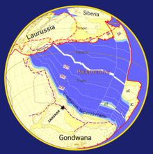
The Cambrian is a major division of the geologic timescale that begins about 541.0 ± 1.0 Ma.[3] Cambrian continents are thought to have resulted from the breakup of a Neoproterozoic supercontinent called Pannotia. The waters of the Cambrian period appear to have been widespread and shallow. Continental drift rates may have been anomalously high. Laurentia, Baltica and Siberia remained independent continents following the break-up of the supercontinent of Pannotia.  Gondwana started to drift toward the South Pole. Panthalassa covered most of the southern hemisphere, and minor oceans included the Proto-Tethys Ocean, Iapetus Ocean and Khanty Ocean.

Ordovician period

The Ordovician period started at a major extinction event called the Cambrian–Ordovician extinction event some time about 485.4 ± 1.9 Ma.[3] During the Ordovician the southern continents were collected into a single continent called Gondwana. Gondwana started the period in the equatorial latitudes and, as the period progressed, drifted toward the South Pole. Early in the Ordovician the continents Laurentia, Siberia and Baltica were still independent continents (since the break-up of the supercontinent Pannotia earlier), but Baltica began to move toward Laurentia later in the period, causing the Iapetus Ocean to shrink between them. Also, Avalonia broke free from Gondwana and began to head north toward Laurentia. The Rheic Ocean was formed as a result of this. By the end of the period, Gondwana had neared or approached the pole and was largely glaciated.

The Ordovician came to a close in a series of extinction events that, taken together, comprise the second-largest of the five major extinction events in Earth's history in terms of percentage of genera that became extinct. The only larger one was the Permian-Triassic extinction event. The extinctions occurred approximately 447 to 444 million years ago [3] and mark the boundary between the Ordovician and the following Silurian Period.

The most-commonly accepted theory is that these events were triggered by the onset of an ice age, in the Hirnantian faunal stage that ended the long, stable greenhouse conditions typical of the Ordovician. The ice age was probably not as long-lasting as once thought; study of oxygen isotopes in fossil brachiopods shows that it was probably no longer than 0.5 to 1.5 million years.[16] The event was preceded by a fall in atmospheric carbon dioxide (from 7000ppm to 4400ppm) which selectively affected the shallow seas where most organisms lived. As the southern supercontinent Gondwana drifted over the South Pole, ice caps formed on it. Evidence of these ice caps have been detected in Upper Ordovician rock strata of North Africa and then-adjacent northeastern South America, which were south-polar locations at the time.

Silurian Period

The Silurian is a major division of the geologic timescale that started about 443.8 ± 1.5 Ma.[3] During the Silurian, Gondwana continued a slow southward drift to high southern latitudes, but there is evidence that the Silurian ice caps were less extensive than those of the late Ordovician glaciation. The melting of ice caps and glaciers contributed to a rise in sea levels, recognizable from the fact that Silurian sediments overlie eroded Ordovician sediments, forming an unconformity. Other cratons and continent fragments drifted together near the equator, starting the formation of a second supercontinent known as Euramerica. The vast ocean of Panthalassa covered most of the northern hemisphere. Other minor oceans include Proto-Tethys, Paleo-Tethys, Rheic Ocean, a seaway of Iapetus Ocean (now in between Avalonia and Laurentia), and newly formed Ural Ocean.

Devonian Period

The Devonian spanned roughly from 419 to 359 Ma.[3] The period was a time of great tectonic activity, as Laurasia and Gondwana drew closer together. The continent Euramerica (or Laurussia) was created in the early Devonian by the collision of Laurentia and Baltica, which rotated into the natural dry zone along the Tropic of Capricorn. In these near-deserts, the Old Red Sandstone sedimentary beds formed, made red by the oxidized iron (hematite) characteristic of drought conditions. Near the equator Pangaea began to consolidate from the plates containing North America and Europe, further raising the northern Appalachian Mountains and forming the Caledonian Mountains in Great Britain and Scandinavia. The southern continents remained tied together in the supercontinent of Gondwana. The remainder of modern Eurasia lay in the Northern Hemisphere. Sea levels were high worldwide, and much of the land lay submerged under shallow seas. The deep, enormous Panthalassa (the "universal ocean") covered the rest of the planet. Other minor oceans were Paleo-Tethys, Proto-Tethys, Rheic Ocean and Ural Ocean (which was closed during the collision with Siberia and Baltica).

Carboniferous Period

The Carboniferous extends from about 358.9 ± 0.4 to about 298.9 ± 0.15 Ma.[3]

A global drop in sea level at the end of the Devonian reversed early in the Carboniferous; this created the widespread epicontinental seas and carbonate deposition of the Mississippian. There was also a drop in south polar temperatures; southern Gondwana was glaciated throughout the period, though it is uncertain if the ice sheets were a holdover from the Devonian or not. These conditions apparently had little effect in the deep tropics, where lush coal swamps flourished within 30 degrees of the northernmost glaciers. A mid-Carboniferous drop in sea-level precipitated a major marine extinction, one that hit crinoids and ammonites especially hard. This sea-level drop and the associated unconformity in North America separate the Mississippian Period from the Pennsylvanian period.[17]

The Carboniferous was a time of active mountain building, as the supercontinent Pangea came together. The southern continents remained tied together in the supercontinent Gondwana, which collided with North America-Europe (Laurussia) along the present line of eastern North America. This continental collision resulted in the Hercynian orogeny in Europe, and the Alleghenian orogeny in North America; it also extended the newly uplifted Appalachians southwestward as the Ouachita Mountains.[18] In the same time frame, much of present eastern Eurasian plate welded itself to Europe along the line of the Ural mountains. There were two major oceans in the Carboniferous the Panthalassa and Paleo-Tethys. Other minor oceans were shrinking and eventually closed the Rheic Ocean (closed by the assembly of South and North America), the small, shallow Ural Ocean (which was closed by the collision of Baltica, and Siberia continents, creating the Ural Mountains) and Proto-Tethys Ocean.


Pangaea separation animation

Permian Period

The Permian extends from about 298.9 ± 0.15 to 252.17 ± 0.06 Ma.[3]
During the Permian all the Earth's major land masses, except portions of East Asia, were collected into a single supercontinent known as Pangaea. Pangaea straddled the equator and extended toward the poles, with a corresponding effect on ocean currents in the single great ocean (Panthalassa, the universal sea), and the Paleo-Tethys Ocean, a large ocean that was between Asia and Gondwana. The Cimmeria continent rifted away from Gondwana and drifted north to Laurasia, causing the Paleo-Tethys to shrink. A new ocean was growing on its southern end, the Tethys Ocean, an ocean that would dominate much of the Mesozoic Era. Large continental landmasses create climates with extreme variations of heat and cold ("continental climate") and monsoon conditions with highly seasonal rainfall patterns. Deserts seem to have been widespread on Pangaea.

Mesozoic Era


Plate tectonics- 249 million years ago

Plate tectonics- 290 million years ago

The Mesozoic extended roughly from 252 to 66 million years ago.[3]

After the vigorous convergent plate mountain-building of the late Paleozoic, Mesozoic tectonic deformation was comparatively mild. Nevertheless, the era featured the dramatic rifting of the supercontinent Pangaea. Pangaea gradually split into a northern continent, Laurasia, and a southern continent, Gondwana. This created the passive continental margin that characterizes most of the Atlantic coastline (such as along the U.S. East Coast) today.

Triassic Period

The Triassic Period extends from about 252.17 ± 0.06 to 201.3 ± 0.2 Ma.[3] During the Triassic, almost all the Earth's land mass was concentrated into a single supercontinent centered more or less on the equator, called Pangaea ("all the land"). This took the form of a giant "Pac-Man" with an east-facing "mouth" constituting the Tethys sea, a vast gulf that opened farther westward in the mid-Triassic, at the expense of the shrinking Paleo-Tethys Ocean, an ocean that existed during the Paleozoic.

The remainder was the world-ocean known as Panthalassa ("all the sea"). All the deep-ocean sediments laid down during the Triassic have disappeared through subduction of oceanic plates; thus, very little is known of the Triassic open ocean. The supercontinent Pangaea was rifting during the Triassic—especially late in the period—but had not yet separated. The first nonmarine sediments in the rift that marks the initial break-up of Pangea—which separated New Jersey from Morocco—are of Late Triassic age; in the U.S., these thick sediments comprise the Newark Supergroup.[19] Because of the limited shoreline of one super-continental mass, Triassic marine deposits are globally relatively rare; despite their prominence in Western Europe, where the Triassic was first studied. In North America, for example, marine deposits are limited to a few exposures in the west. Thus Triassic stratigraphy is mostly based on organisms living in lagoons and hypersaline environments, such as Estheria crustaceans and terrestrial vertebrates.[20]

Jurassic Period

The Jurassic Period extends from about 201.3 ± 0.2 to 145.0 Ma.[3] During the early Jurassic, the supercontinent Pangaea broke up into the northern supercontinent Laurasia and the southern supercontinent Gondwana; the Gulf of Mexico opened in the new rift between North America and what is now Mexico's Yucatan Peninsula. The Jurassic North Atlantic Ocean was relatively narrow, while the South Atlantic did not open until the following Cretaceous Period, when Gondwana itself rifted apart.[21] The Tethys Sea closed, and the Neotethys basin appeared. Climates were warm, with no evidence of glaciation. As in the Triassic, there was apparently no land near either pole, and no extensive ice caps existed. The Jurassic geological record is good in western Europe, where extensive marine sequences indicate a time when much of the continent was submerged under shallow tropical seas; famous locales include the Jurassic Coast World Heritage Site and the renowned late Jurassic lagerstätten of Holzmaden and Solnhofen.[22] In contrast, the North American Jurassic record is the poorest of the Mesozoic, with few outcrops at the surface.[23] Though the epicontinental Sundance Sea left marine deposits in parts of the northern plains of the United States and Canada during the late Jurassic, most exposed sediments from this period are continental, such as the alluvial deposits of the Morrison Formation. The first of several massive batholiths were emplaced in the northern Cordillera beginning in the mid-Jurassic, marking the Nevadan orogeny.[24] Important Jurassic exposures are also found in Russia, India, South America, Japan, Australasia and the United Kingdom.

Cretaceous Period


Plate tectonics- 100 Ma,[3] Cretaceous period

The Cretaceous Period extends from circa 145 million years ago to 66 million years ago.[3]

During the Cretaceous, the late Paleozoic-early Mesozoic supercontinent of Pangaea completed its breakup into present day continents, although their positions were substantially different at the time. As the Atlantic Ocean widened, the convergent-margin orogenies that had begun during the Jurassic continued in the North American Cordillera, as the Nevadan orogeny was followed by the Sevier and Laramide orogenies. Though Gondwana was still intact in the beginning of the Cretaceous,  Gondwana itself broke up as South America, Antarctica and Australia rifted away from Africa (though India and Madagascar remained attached to each other); thus, the South Atlantic and Indian Oceans were newly formed. Such active rifting lifted great undersea mountain chains along the welts, raising eustatic sea levels worldwide.

To the north of Africa the Tethys Sea continued to narrow. Broad shallow seas advanced across central North America (the Western Interior Seaway) and Europe, then receded late in the period, leaving thick marine deposits sandwiched between coal beds. At the peak of the Cretaceous transgression, one-third of Earth's present land area was submerged.[25] The Cretaceous is justly famous for its chalk; indeed, more chalk formed in the Cretaceous than in any other period in the Phanerozoic.[26] Mid-ocean ridge activity—or rather, the circulation of seawater through the enlarged ridges—enriched the oceans in calcium; this made the oceans more saturated, as well as increased the bioavailability of the element for calcareous nanoplankton.[27] These widespread carbonates and other sedimentary deposits make the Cretaceous rock record especially fine. Famous formations from North America include the rich marine fossils of Kansas's Smoky Hill Chalk Member and the terrestrial fauna of the late Cretaceous Hell Creek Formation. Other important Cretaceous exposures occur in Europe and China. In the area that is now India, massive lava beds called the Deccan Traps were laid down in the very late Cretaceous and early Paleocene.

Cenozoic Era

The Cenozoic Era covers the 66 million years since the Cretaceous–Paleogene extinction event up to and including the present day. By the end of the Mesozoic era, the continents had rifted into nearly their present form. Laurasia became North America and Eurasia, while Gondwana split into South America, Africa, Australia, Antarctica and the Indian subcontinent, which collided with the Asian plate. This impact gave rise to the Himalayas. The Tethys Sea, which had separated the northern continents from Africa and India, began to close up, forming the Mediterranean sea.

Paleogene Period

The Paleogene (alternatively Palaeogene) Period is a unit of geologic time that began 66 and ended 23.03 Ma[3] and comprises the first part of the Cenozoic Era. This period consists of the Paleocene, Eocene and Oligocene Epochs.
Paleocene Epoch
The Paleocene, lasted from 66 million years ago to 56 million years ago.[3]

In many ways, the Paleocene continued processes that had begun during the late Cretaceous Period. During the Paleocene, the continents continued to drift toward their present positions. Supercontinent Laurasia had not yet separated into three continents. Europe and Greenland were still connected. North America and Asia were still intermittently joined by a land bridge, while Greenland and North America were beginning to separate.[28] The Laramide orogeny of the late Cretaceous continued to uplift the Rocky Mountains in the American west, which ended in the succeeding epoch. South and North America remained separated by equatorial seas (they joined during the Neogene); the components of the former southern supercontinent Gondwana continued to split apart, with Africa, South America, Antarctica and Australia pulling away from each other. Africa was heading north toward Europe, slowly closing the Tethys Ocean, and India began its migration to Asia that would lead to a tectonic collision and the formation of the Himalayas.
Eocene Epoch
During the Eocene (56 million years ago - 33.9 million years ago),[3] the continents continued to drift toward their present positions. At the beginning of the period, Australia and Antarctica remained connected, and warm equatorial currents mixed with colder Antarctic waters, distributing the heat around the world and keeping global temperatures high. But when Australia split from the southern continent around 45 Ma, the warm equatorial currents were deflected away from Antarctica, and an isolated cold water channel developed between the two continents. The Antarctic region cooled down, and the ocean surrounding Antarctica began to freeze, sending cold water and ice floes north, reinforcing the cooling. The present pattern of ice ages began about 40 million years ago.

The northern supercontinent of Laurasia began to break up, as Europe, Greenland and North America drifted apart. In western North America, mountain building started in the Eocene, and huge lakes formed in the high flat basins among uplifts. In Europe, the Tethys Sea finally vanished, while the uplift of the Alps isolated its final remnant, the Mediterranean, and created another shallow sea with island archipelagos to the north. Though the North Atlantic was opening, a land connection appears to have remained between North America and Europe since the faunas of the two regions are very similar. India continued its journey away from Africa and began its collision with Asia, creating the Himalayan orogeny.
Oligocene Epoch
The Oligocene Epoch extends from about 34 million years ago to 23 million years ago.[3] During the Oligocene the continents continued to drift toward their present positions.

Antarctica continued to become more isolated and finally developed a permanent ice cap. Mountain building in western North America continued, and the Alps started to rise in Europe as the African plate continued to push north into the Eurasian plate, isolating the remnants of Tethys Sea. A brief marine incursion marks the early Oligocene in Europe. There appears to have been a land bridge in the early Oligocene between North America and Europe since the faunas of the two regions are very similar. During the Oligocene, South America was finally detached from Antarctica and drifted north toward North America. It also allowed the Antarctic Circumpolar Current to flow, rapidly cooling the continent.

Neogene Period

The Neogene Period is a unit of geologic time starting 23.03 Ma.[3] and ends at 2.588 Mya. The Neogene Period follows the Paleogene Period. The Neogene consists of the Miocene and Pliocene and is followed by the Quaternary Period.
Miocene Epoch
The Miocene extends from about 23.03 to 5.333 Ma.[3]

During the Miocene continents continued to drift toward their present positions. Of the modern geologic features, only the land bridge between South America and North America was absent, the subduction zone along the Pacific Ocean margin of South America caused the rise of the Andes and the southward extension of the Meso-American peninsula. India continued to collide with Asia. The Tethys Seaway continued to shrink and then disappeared as Africa collided with Eurasia in the Turkish-Arabian region between 19 and 12 Ma (ICS 2004). Subsequent uplift of mountains in the western Mediterranean region and a global fall in sea levels combined to cause a temporary drying up of the Mediterranean Sea resulting in the Messinian salinity crisis near the end of the Miocene.
Pliocene Epoch
The Pliocene extends from 5.333 million years ago to 2.588 million years ago.[3] During the Pliocene continents continued to drift toward their present positions, moving from positions possibly as far as 250 kilometres (155 mi) from their present locations to positions only 70 km from their current locations.

South America became linked to North America through the Isthmus of Panama during the Pliocene, bringing a nearly complete end to South America's distinctive marsupial faunas. The formation of the Isthmus had major consequences on global temperatures, since warm equatorial ocean currents were cut off and an Atlantic cooling cycle began, with cold Arctic and Antarctic waters dropping temperatures in the now-isolated Atlantic Ocean. Africa's collision with Europe formed the Mediterranean Sea, cutting off the remnants of the Tethys Ocean. Sea level changes exposed the land-bridge between Alaska and Asia. Near the end of the Pliocene, about 2.58 million years ago (the start of the Quaternary Period), the current ice age began. The polar regions have since undergone repeated cycles of glaciation and thaw, repeating every 40,000–100,000 years.

Quaternary Period

Pleistocene Epoch
The Pleistocene extends from 2.588 million years ago to 11,700 years before present.[3] The modern continents were essentially at their present positions during the Pleistocene, the plates upon which they sit probably having moved no more than 100 kilometres (62 mi) relative to each other since the beginning of the period.
Holocene Epoch
3D
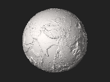
Current Earth - without water (click/enlarge to "spin" 3D-globe).

The Holocene Epoch began approximately 11,700 calendar years before present[3] and continues to the present. During the Holocene, continental motions have been less than a kilometer.

The last glacial period of the current ice age ended about 10,000 years ago.[29] Ice melt caused world sea levels to rise about 35 metres (115 ft) in the early part of the Holocene. In addition, many areas above about 40 degrees north latitude had been depressed by the weight of the Pleistocene glaciers and rose as much as 180 metres (591 ft) over the late Pleistocene and Holocene, and are still rising today. The sea level rise and temporary land depression allowed temporary marine incursions into areas that are now far from the sea. Holocene marine fossils are known from Vermont, Quebec, Ontario and Michigan. Other than higher latitude temporary marine incursions associated with glacial depression, Holocene fossils are found primarily in lakebed, floodplain and cave deposits. Holocene marine deposits along low-latitude coastlines are rare because the rise in sea levels during the period exceeds any likely upthrusting of non-glacial origin. Post-glacial rebound in Scandinavia resulted in the emergence of coastal areas around the Baltic Sea, including much of Finland. The region continues to rise, still causing weak earthquakes across Northern Europe. The equivalent event in North America was the rebound of Hudson Bay, as it shrank from its larger, immediate post-glacial Tyrrell Sea phase, to near its present boundaries.

Structure of the Earth

From Wikipedia, the free encyclopedia

Structure of the Earth

The interior structure of the Earth is layered in spherical shells: an outer silicate solid crust, a highly viscous asthenosphere and mantle, a liquid outer core that is much less viscous than the mantle, and a solid inner core. Scientific understanding of the internal structure of the Earth is based on observations of topography and bathymetry, observations of rock in outcrop, samples brought to the surface from greater depths by volcanoes or volcanic activity, analysis of the seismic waves that pass through the Earth, measurements of the gravitational and magnetic fields of the Earth, and experiments with crystalline solids at pressures and temperatures characteristic of the Earth's deep interior.

Mass

The force exerted by Earth's gravity can be used to calculate its mass. Astronomers can also calculate Earth's mass by observing the motion of orbiting satellites. Earth’s average density can be determined through gravimetric experiments, which have historically involved pendulums.

The mass of Earth is about 6×1024 kg.[1]

Structure

Earth's radial density distribution according to the preliminary reference earth model (PREM).[2]
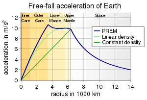
Earth's gravity according to the preliminary reference earth model (PREM).[2] Comparison to approximations using constant and linear density for Earth's interior.
Mapping the interior of Earth with earthquake waves.
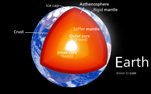
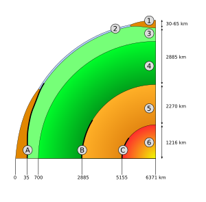
Schematic view of the interior of Earth. 1. continental crust – 2. oceanic crust – 3. upper mantle – 4. lower mantle – 5. outer core – 6. inner core – A: Mohorovičić discontinuity – B: Gutenberg Discontinuity – C: Lehmann–Bullen discontinuity.

The structure of Earth can be defined in two ways: by mechanical properties such as rheology, or chemically. Mechanically, it can be divided into lithosphere, asthenosphere, mesospheric mantle, outer core, and the inner core. Chemically, Earth can be divided into the crust, upper mantle, lower mantle, outer core, and inner core. The geologic component layers of Earth[3][not in citation given] are at the following depths below the surface:

Depth Layer
Kilometres Miles
0–60 0–37 Lithosphere (locally varies between 5 and 200 km)
0–35 0–22 … Crust (locally varies between 5 and 70 km)
35–60 22–37 … Uppermost part of mantle
35–2,890 22–1,790 Mantle
210-270 130-168 … Upper mesosphere (upper mantle)
660–2,890 410–1,790 … Lower mesosphere (lower mantle)
2,890–5,150 1,790–3,160 Outer core
5,150–6,360 3,160–3,954 Inner core

The layering of Earth has been inferred indirectly using the time of travel of refracted and reflected seismic waves created by earthquakes. The core does not allow shear waves to pass through it, while the speed of travel (seismic velocity) is different in other layers. The changes in seismic velocity between different layers causes refraction owing to Snell's law, like light bending as it passes through a prism. Likewise, reflections are caused by a large increase in seismic velocity and are similar to light reflecting from a mirror.

Crust

The crust ranges from 5–70 kilometres (3.1–43.5 mi) in depth and is the outermost layer. The thin parts are the oceanic crust, which underlie the ocean basins (5–10 km) and are composed of dense (mafic) iron magnesium silicate igneous rocks, like basalt. The thicker crust is continental crust, which is less dense and composed of (felsic) sodium potassium aluminium silicate rocks, like granite. The rocks of the crust fall into two major categories – sial and sima (Suess,1831–1914). It is estimated that sima starts about 11 km below the Conrad discontinuity (a second order discontinuity). The uppermost mantle together with the crust constitutes the lithosphere. The crust-mantle boundary occurs as two physically different events. First, there is a discontinuity in the seismic velocity, which is most commonly known as the Mohorovičić discontinuity or Moho. The cause of the Moho is thought to be a change in rock composition from rocks containing plagioclase feldspar (above) to rocks that contain no feldspars (below). Second, in oceanic crust, there is a chemical discontinuity between ultramafic cumulates and tectonized harzburgites, which has been observed from deep parts of the oceanic crust that have been obducted onto the continental crust and preserved as ophiolite sequences.

Many rocks now making up Earth's crust formed less than 100 million (1×10⁸) years ago; however, the oldest known mineral grains are about 4.4 billion (4.4×10⁹) years old, indicating that Earth has had a solid crust for at least 4.4 billion years.[4]

Mantle


World map showing the position of the Moho.

Earth's mantle extends to a depth of 2,890 km, making it the thickest layer of Earth. The mantle is divided into upper and lower mantle. The upper and lower mantle are separated by the transition zone. The lowest part of the mantle next to the core-mantle boundary is known as the D″ (pronounced dee-double-prime[5]) layer. The pressure at the bottom of the mantle is ≈140 GPa (1.4 Matm). The mantle is composed of silicate rocks that are rich in iron and magnesium relative to the overlying crust. Although solid, the high temperatures within the mantle cause the silicate material to be sufficiently ductile that it can flow on very long timescales. Convection of the mantle is expressed at the surface through the motions of tectonic plates. As there is intense and increasing pressure as one travels deeper into the mantle, the lower part of the mantle flows less easily than does the upper mantle (chemical changes within the mantle may also be important). The viscosity of the mantle ranges between 1021 and 1024 Pa·s, depending on depth.[6] In comparison, the viscosity of water is approximately 10−3 Pa·s and that of pitch is 107 Pa·s. The source of heat that drives plate tectonics is the primordial heat left over from the planet’s formation as well as the radioactive decay of uranium, thorium, and potassium in Earth’s crust and mantle.[7]

Core

The average density of Earth is 5,515 kg/m3. Because the average density of surface material is only around 3,000 kg/m3, we must conclude that denser materials exist within Earth's core. Seismic measurements show that the core is divided into two parts, a "solid" inner core with a radius of ≈1,220 km[8] and a liquid outer core extending beyond it to a radius of ≈3,400 km. The densities are between 9,900 and 12,200 kg/m3 in the outer core and 12,600–13,000 kg/m3 in the inner core.[9]

The inner core was discovered in 1936 by Inge Lehmann and is generally believed to be composed primarily of iron and some nickel. Since this layer is able to transmit shear waves (transverse seismic waves), it must be solid. Experimental evidence has at times been critical of crystal models of the core.[10] Other experimental studies show a discrepancy under high pressure: diamond anvil (static) studies at core pressures yield melting temperatures that are approximately 2000 K below those from shock laser (dynamic) studies.[11][12] The laser studies create plasma,[13] and the results are suggestive that constraining inner core conditions will depend on whether the inner core is a solid or is a plasma with the density of a solid. This is an area of active research.

In early stages of Earth's formation about four and a half billion (4.5×10⁹) years ago, melting would have caused denser substances to sink toward the center in a process called planetary differentiation, while less-dense materials would have migrated to the crust. The core is thus believed to largely be composed of iron (80%), along with nickel and one or more light elements, whereas other dense elements, such as lead and uranium, either are too rare to be significant or tend to bind to lighter elements and thus remain in the crust (see felsic materials). Some have argued that the inner core may be in the form of a single iron crystal.[14][15]

Under laboratory conditions a sample of iron–nickel alloy was subjected to the corelike pressures by gripping it in a vise between 2 diamond tips (diamond anvil cell), and then heating to approximately 4000 K. The sample was observed with x-rays, and strongly supported the theory that Earth's inner core was made of giant crystals running north to south.[16][17]

The liquid outer core surrounds the inner core and is believed to be composed of iron mixed with nickel and trace amounts of lighter elements.

Recent speculation suggests that the innermost part of the core is enriched in gold, platinum and other siderophile elements.[18]

The matter that comprises Earth is connected in fundamental ways to matter of certain chondrite meteorites, and to matter of outer portion of the Sun.[19][20] There is good reason to believe that Earth is, in the main, like a chondrite meteorite. Beginning as early as 1940, scientists, including Francis Birch, built geophysics upon the premise that Earth is like ordinary chondrites, the most common type of meteorite observed impacting Earth, while totally ignoring another, albeit less abundant type, called enstatite chondrites. The principal difference between the two meteorite types is that enstatite chondrites formed under circumstances of extremely limited available oxygen, leading to certain normally oxyphile elements existing either partially or wholly in the alloy portion that corresponds to the core of Earth.

Dynamo theory suggests that convection in the outer core, combined with the Coriolis effect, gives rise to Earth's magnetic field. The solid inner core is too hot to hold a permanent magnetic field (see Curie temperature) but probably acts to stabilize the magnetic field generated by the liquid outer core. The average magnetic field strength in Earth's outer core is estimated to be 25 Gauss (2.5 mT), 50 times stronger than the magnetic field at the surface.[21][22]

Recent evidence has suggested that the inner core of Earth may rotate slightly faster than the rest of the planet;[23] however, more recent studies in 2011[which?] found this hypothesis to be inconclusive. Options remain for the core which may be oscillatory in nature or a chaotic system.[citation needed] In August 2005 a team of geophysicists announced in the journal Science that, according to their estimates, Earth's inner core rotates approximately 0.3 to 0.5 degrees per year faster relative to the rotation of the surface.[24][25]

The current scientific explanation for Earth's temperature gradient is a combination of heat left over from the planet's initial formation, decay of radioactive elements, and freezing of the inner core.

Geology of the Pacific Northwest

From Wikipedia, the free encyclopedia

The Pacific Northwest from space

The geology of the Pacific Northwest includes the composition (including rock, minerals, and soils), structure, physical properties and the processes that shape the Pacific Northwest region of the United States and Canada. The geology of the region is responsible for some of area's scenic beauty as well as some of its hazards, such as volcanoes and earthquakes.

There are at least five geologic provinces in the area: the Cascade Volcanoes, the Columbia Plateau, the North Cascades, the Coast Mountains, and the Insular Mountains. The Cascade Volcanoes are an active volcanic region along the western side of the Pacific Northwest. The Columbia Plateau is a region of subdued geography that is inland of the Cascade Volcanoes, and the North Cascades are a mountainous region in the northwest corner of the United States, extending into British Columbia. The Coast Mountains and Insular Mountains are a strip of mountains along the coast of British Columbia, each with its own geological history.

The geology of the Pacific Northwest is vast and complex. Most of the region was formed about 200 million years ago as the North American Plate started to drift westward during the rifting of Pangaea. Since that date, the western edge of North America has grown westward as a succession of island arcs and assorted ocean-floor rocks have been added along the continental margin.

Volcanoes

The Cascade Volcanoes

The Cascades Province forms an arc-shaped band extending from southwestern British Columbia to Northern California, roughly parallel to the Pacific coastline. Within this region, nearly 20 major volcanic centers lie in sequence like a string of explosive pearls.[1]


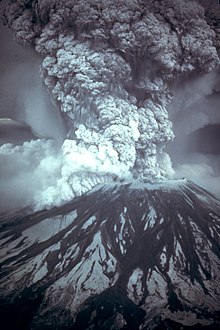
Mount St. Helens erupts on May 18, 1980

Although the largest volcanoes like Mount St. Helens get the most attention, the Cascade Volcanic Arc includes a band of thousands of very small, short-lived volcanoes that have built a platform of lava and volcanic debris. Rising above this volcanic platform are a few strikingly large volcanoes that dominate the landscape.[1]

The Cascade volcanoes define the Pacific Northwest section of the Ring of Fire, an array of volcanoes that rim the Pacific Ocean. The Ring of Fire is also known for its frequent earthquakes. The volcanoes and earthquakes arise from a common source: subduction.[2]

Beneath the Cascade Volcanic Arc, a dense oceanic plate plunges beneath the North American Plate; a process known as subduction. As the oceanic slab sinks deep into the Earth's interior beneath the continental plate, high temperatures and pressures allow water molecules locked in the minerals of solid rock to escape. The water vapor rises into the pliable mantle above the subducting plate, causing some of the mantle to melt. This newly formed magma rises toward the Earth's surface to erupt, forming a chain of volcanoes (the Cascade Volcanic Arc) above the subduction zone.[2]

A close-up look at the Cascades reveals a more complicated picture than a simple subduction zone.[2]

Not far off the coast of the North Pacific lies a spreading ridge; a divergent plate boundary made up of a series of breaks in the oceanic crust where new ocean crust is created. On one side of the spreading ridge new Pacific Plate crust is made, then moves away from the ridge. On the other side of the spreading ridge the Juan de Fuca and Gorda Plates move eastward.[2]


Image of the Juan de Fuca Plate that produced the magnitude 8.7–9.2 Cascadia earthquake in 1700.

There are some unusual features at the Cascade subduction zone. Where the Juan de Fuca Plate sinks beneath the North American Plate there is no deep trench, seismicity (earthquakes) is less than expected, and there is evidence of a decline in volcanic activity over the past few million years. The probable explanation lies in the rate of convergence between the Juan de Fuca and North American Plates. These two plates converge at 3–4 centimeters per year at present. This is only about half the rate of convergence of 7 million years ago.[2]

The small Juan de Fuca Plate and two platelets, the Explorer Plate and Gorda Plate are the meager remnants of the much larger Farallon oceanic plate. The Explorer Plate broke away from the Juan de Fuca about 4 million years ago and shows no evidence that it is still being subducted. The Gorda platelet split away between 18 and 5 million years ago and continues to sink beneath North America.[2]

The Cascade Volcanic Arc made its first appearance 36 million years ago, but the major peaks that rise up from today's volcanic centers were born within the last 1.6 million years. More than 3,000 vents erupted during the most recent volcanic episode that began 5 million years ago. As long as subduction continues, new Cascade volcanoes will continue to rise.[2]

Volcanism outside the Cascades


Map of the Garibaldi Volcanic Belt centers.

The Garibaldi Volcanic Belt in southwestern British Columbia is the northern extension of the Cascade Volcanic Arc in the United States and contains the most explosive young volcanoes in Canada. Like the rest of the arc, it has its origins in the Cascadia subduction zone. Volcanoes of the Garibaldi Volcanic Belt have been sporadically active over a time span of several millions of years. The northernmost member, the Mount Meager massif, was responsible for a major catastrophic eruption that occurred about 2,350 years ago. This eruption may have been close in size to that of the 1980 eruption of Mount St. Helens. Ash from this eruption can be traced eastward to western Alberta. It is also the most unstable volcanic massive in Canada, which has dumped clay and rock several meters deep into the Pemberton Valley at least three times during the past 7,300 years. Hot springs near the Mount Cayley and Mount Meager massifs suggest that magmatic heat is still present. The long history of volcanism in the region, coupled with continued subduction off the coast, suggests that volcanism has not yet ended in the Garibaldi Volcanic Belt. A few isolated volcanic centers northwest of the Mount Meager massif such as the Franklin Glacier Complex and the Silverthrone Caldera, which lie in the Pemberton Volcanic Belt, may also be the product of Cascadia subduction, but geologic investigations have been very limited in this remote region. About 5–7 million years ago, the northern end of the Juan de Fuca Plate broke off along the Nootka Fault to form the Explorer Plate, and there is no definitive consensus among geologists on the relation of the volcanoes north of that fault to the rest of the Cascade Arc. However, the Pemberton Volcanic Belt is usually merged with the Garibaldi Volcanic Belt, making Mount Silverthrone the northernmost, but an uncertain Cascadia subduction-related volcano.


Mount Edziza, a large shield volcano in northwestern British Columbia

The most active volcanic region of the northern Pacific Northwest is called the Northern Cordilleran Volcanic Province (sometimes called the Stikine Volcanic Belt). It contains more than 100 young volcanoes and several eruptions known to have occurred within the last 400 years. The last eruptions within the volcanic belt was about 150 years ago at The Volcano in the Iskut-Unuk River Cones volcanic field. The most voluminous and most persistent eruptive center within the belt and in Canada is Level Mountain. It is a large shield volcano that covers an area of 1,800 km2 (690 sq mi) southwest of Dease Lake and north of Telegraph Creek. The broad dissected summit region consists of trachytic and rhyolitic lava domes and was considered to be dotted with several minor basaltic vents of postglacial age, although considered Holocene activity to be uncertain. The Mount Edziza volcanic complex is perhaps the most spectacular volcanic edifice in British Columbia. It is the second largest persistent eruptive center within the Northern Cordilleran Volcanic Province and is flanked with numerous young satellite cones, including the young, well-preserved Eve Cone. There are some indications that Level Mountain and Mount Edziza volcanic complex may be between 11 and 9 million years old.


Map of the Anahim Volcanic Belt centers.

The Anahim Volcanic Belt is a volcanic belt that stretches from just north of Vancouver Island to near Quesnel. It is thought to have formed as a result of the North American Plate moving over a stationary hotspot, similar to the hotspot feeding the Hawaiian Islands, called the Anahim hotspot. The youngest volcano within the volcanic belt is Nazko Cone. It last erupted about 7,000 years ago, producing two small lava flows that traveled 1 km (0.6 mi) to the west, along with a blanket of volcanic ash that extends several km to the north and east of the cone. The volcanic belt also contains three large shield volcanoes that were formed between 8 and 1 million years ago, called the Ilgachuz Range, Rainbow Range and the Itcha Range.

The Chilcotin Group in southern British Columbia is a north-south range of volcanoes, thought to have formed as a result of back-arc extension behind the Cascadia subduction zone. The majority of the eruptions in this belt happened either 6 to 10 million years ago (Miocene) or 2–3 million years ago (Pliocene). However, there have been few eruptions in the Pleistocene.[3]

The Wells Gray-Clearwater volcanic field in south-eastern British Columbia consists of several small basaltic volcanoes and extensive lava flows that have been active for the past 3 million years.[4] It is within the Wells Gray Provincial Park, which also includes the 142 m (465 ft)-high Helmcken Falls. The origin of the volcanism is unknown, but is probably related to crustal thinning. Some of the lava flows in the field are similar to those that erupted at Volcano Mountain in the Yukon, where olivine nephelinite occurs. The last eruption in the field was about 400 years ago at Kostal Cone.

Numerous seamounts lie off British Columbia's coast and are related to hotspot volcanism. The Bowie Seamount located 180 km (110 mi) west of the Queen Charlotte Islands, is perhaps the shallowest seamount in Canada's Pacific waters. Because of its shallow depth, scientists believe it was an active volcanic island throughout the last ice age. The Bowie Seamount is also the youngest seamount in the Kodiak-Bowie Seamount chain.

Volcanic disasters

The last eruption of the Tseax Cone around the years 1750 or 1775 is Canada's worst known geophysical disaster. The eruption produced a 22.5 km (14.0 mi) long lava flow, destroying the Nisga'a villages and the death of at least 2000 Nisga'a people by volcanic gases and poisonous smoke. The Nass River valley was inundated by the lava flows and contain abundant tree molds and lava tubes. The event coincided with the arrival of the first European explorers to penetrate the uncharted coastal waters of northern British Columbia. Today, the basaltic lava deposits are a draw to tourists and are part of the Nisga'a Memorial Lava Beds Provincial Park.

Recent volcanic activity


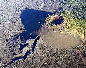
Lava Butte, Oregon, erupted roughly 5000 years BCE

The Pacific Northwest volcanoes continue to be a geologically active area. The most geologically recent volcanic eruptions include:

Seismic activity


State Route 302 after the Nisqually earthquake

The Pacific Northwest is seismically active. The Juan de Fuca Plate is capable of producing megathrust earthquakes of moment magnitude 9: the last such earthquake was the 1700 Cascadia earthquake, which produced a tsunami in Japan,[5] and may have temporarily blocked the Columbia River with the Bonneville Slide.[6] More recently, in 2001, the Nisqually earthquake (magnitude 6.8) struck 16 km (10 mi) northeast of Olympia, Washington, causing some structural damage and panic.

In addition, eleven volcanoes in Canada have had seismic activity since 1975, including: the Silverthrone Caldera, Mount Meager massif, Wells Gray-Clearwater volcanic field, Mount Garibaldi, Mount Cayley massif, Castle Rock, The Volcano, Mount Edziza volcanic complex, Hoodoo Mountain, Crow Lagoon and Nazko Cone.[7]

Columbia Plateau


The Columbia River basalts cover portions of three states

The Columbia Plateau province is enveloped by one of the world's largest accumulations of lava. Over 500,000 km2 (190,000 sq mi) of the Earth's surface is covered by it. The topography here is dominated by geologically young lava flows that inundated the countryside with amazing speed, all within the last 17 million years.[8]

Over 170,000 km3 (41,000 cu mi) of basaltic lava, known as the Columbia River basalts, covers the western part of the province. These tremendous flows erupted between 17–6 million years ago. Most of the lava flooded out in the first 1.5 million years: an extraordinarily short time for such an outpouring of molten rock.[8]

The Snake River Plain stretches across Oregon, through northern Nevada, southern Idaho, and ends at the Yellowstone Plateau in Wyoming. Looking like a great spoon scooped out the Earth surface, the smooth topography of this province forms a striking contrast with the strong mountainous fabric around it.[8]

The Snake River Plain lies in a distinct depression. At the western end, the base has dropped down along normal faults, forming a graben structure. Although there is extensive faulting at the eastern end, the structure is not as clear.[8]


A map of the Snake River Plain, showing its smooth topography

Like the Columbia River region, volcanic eruptions dominate the story of the Snake River Plain in the eastern part of the Columbia Plateau Province. The earliest Snake River Plain eruptions began about 15 million years ago, just as the tremendous early eruptions of Columbia River Basalt were ending. But most of the Snake River Plain volcanic rock is less than a few million years old, Pliocene age (5-1.6 million years ago) and younger.[8]

In the west, the Columbia River Basalts are just that: almost exclusively black basalt. Not so in the Snake River Plain, where relatively quiet eruptions of soupy black basalt lava flows alternated with tremendous explosive eruptions of rhyolite, a light-colored volcanic rock.[8]

Cinder cones dot the landscape of the Snake River Plain. Some are aligned along vents, the fissures that fed flows and cone-building eruptions. Calderas, great pits formed by explosive volcanism, and low shield volcanoes, and rhyolite hills are also part of the landscape here, but many are obscured by later lava flows.[8]

Evidence suggests that some concentrated heat source is melting rock beneath the Columbia Plateau Province. At the base of the lithosphere (the layer of crust and upper mantle that forms Earth's moving tectonic plates). In an effort to figure out why this area, far from a plate boundary, had such an enormous outpouring of lava, scientists established hardening dates for many of the individual lava flows. They found that the youngest volcanic rocks were clustered near the Yellowstone Plateau, and that the farther west they went, the older the lavas.[8]

Although scientists are still gathering evidence, a probable explanation is that a hot spot, an extremely hot plume of deep mantle material, is rising to the surface beneath the Columbia Plateau Province. Geologists know that beneath Hawaii and Iceland, a temperature instability develops (for reasons not yet well understood) at the boundary between the core and mantle. The concentrated heat triggers a plume hundreds of kilometers in diameter that ascends directly through to the surface of the Earth.[8]

When the hot plume arrives at the base of the lithosphere, some of the lighter rock of the lithosphere rapidly melts. It is this molten lithosphere that becomes the basalt lavas that gush onto the surface to form the Columbia River and Snake River Plain basalts.[8]

The track of this hot spot starts in the west and sweeps up to Yellowstone National Park. The steaming fumaroles and explosive geysers are ample evidence of a concentration of heat beneath the surface. The hotspot is probably quite stationary, but the North American plate is moving over it, creating a superb record of the rate and direction of plate motion.[8]

The Ice Age floods

With the beginning of the Pleistocene time (about one million years ago), cooling temperatures provided conditions favorable for the creation of continental glaciers. Over the centuries, as snowfall exceeded melting and evaporation, a great accumulation of snow covered part of the continent, forming extensive ice fields. This vast continental ice sheet reached a thickness of about 1,200 m (4,000 ft) in some areas. Sufficient pressure on the ice caused it to flow outward as a glacier. The glacier moved south out of Canada, damming rivers and creating lakes in Washington, Idaho and Montana.[9]
The ice blocked the Clark Fork River, forming the huge Glacial Lake Missoula. The lake measured about 7,700 km2 (3,000 sq mi) and contained about 2,100 km3 (500 cu mi), half the volume of Lake Michigan.[10]


The immense floods created channels that are presently dry, such as the Drumheller Channels

Glacial Lake Missoula eventually broke through the ice dam, allowing a tremendous volume of water to rush across northern Idaho and into eastern Washington. Such catastrophic floods raced across the southward-dipping plateau a number of times, etching the coulees which characterize this region, now known as the channeled scablands.[9]

As the floods in this vicinity raced southward, two major cascades formed along their course. The larger cataract was that of the upper Grand Coulee, where the river roared over an 240 m (800 ft) waterfall. The eroding power of the water plucked pieces of basalt from the precipice, causing the falls to retreat 32 km (20 mi) and self-destruct by cutting through to the Columbia River valley near what is now the Grand Coulee Dam.[9]

The other major cataract is now known as Dry Falls. It started near Soap Lake in Washington State, where less resistant basalt layers gave way before the great erosive power of this tremendous torrent and waterfalls developed. As in the upper Grand Coulee, the raging river yanked chunks of rock from the face of the falls and the falls eventually retreated to their present location. Dry Falls is three and one-half miles wide, with a drop of more than 120 m (400 ft). By way of comparison, Niagara Falls, 1.6 km (1 mi) wide with a drop of only 50 m (165 ft), would be dwarfed by Dry Falls.[9]

The North Cascades

The North Cascade Range in Washington is part of the American cordillera, a mountain chain stretching more than 19,000 km (12,000 mi) from Tierra del Fuego to the Alaska Peninsula, and second only to the Alpine-Himalayan chain in height. Although only a small part of the Cordillera, mile for mile, the North Cascade Range is steeper and wetter than most other ranges in the conterminous United States.[11]
In geology, the range has more in common with the Coast Ranges of British Columbia and Alaska than it does with its Cordilleran cousins in the Rocky Mountains or Sierra Nevada. Although the peaks of the North Cascades do not reach great elevations (high peaks are generally in the 2,100 to 2,400 m (7,000 to 8,000 ft) range, their overall relief, the relatively uninterrupted vertical distance from valley bottom to mountain top, is commonly 1,200 to 1,800 m (4,000 to 6,000 ft).[11]

Rocks of the North Cascades record at least 400 million years of history: time enough to have collected a jumble of different rocks. The range is a geologic mosaic made up of volcanic island arcs, deep ocean sediments, basaltic ocean floor, parts of old continents, submarine fans, and even pieces of the deep subcrustal mantle of the earth. The disparate pieces of the North Cascade mosaic were born far from one another but subsequently drifted together, carried along by the tectonic plates that make up the Earth's outer shell. Over time, the moving plates eventually accreted the various pieces of the mosaic onto the western side of North America.[11]

As if this mosaic of unrelated pieces were not complex enough, some of the assembled pieces were uplifted, eroded by streams, and then locally buried in their own eroded debris; other pieces were forced deep into the Earth to be heated and squeezed, almost beyond recognition, and then raised again to view.[11]

About 35 million years ago, a volcanic arc grew across this complex mosaic of old terranes. Volcanoes erupted to cover the older rocks with lava and ash. Large masses of molten rock invaded the older rocks from below. The volcanic arc is still active today, decorating the skyline with the cones of Mount Baker and Glacier Peak.[11]


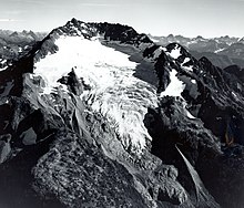
The North Cascades are heavily eroded by glaciers

The deep canyons and sharp peaks of today's North Cascades scene are products of profound erosion. Running water has etched out the grain of the range, landslides have softened the abrupt edges, homegrown glaciers have scoured the peaks and high valleys and, during the Ice Age, the Cordilleran Ice Sheet overrode almost all the range and rearranged courses of streams. Erosion has written and still writes its own history in the mountains, but it has also revealed the complex mosaic of the bedrock.[11]

Coast Mountains

The Coast Mountains are the western range of the North American mainland cordillera, covering the Alaska Panhandle and most of coastal British Columbia. The range is approximately 1,600 km (1,000 mi) long and 200 km (120 mi) wide.

Most of the Coast Mountains are composed of granite, which is part of the Coast Plutonic Complex. This is the single largest contiguous granite outcropping in the world, which extends approximately 1,800 km (1,100 mi) in length. It is a large batholith complex. Its formation is related to subduction of the Kula and Farallon tectonic plates along the continental margin during the Jurassic-to-Eocene periods. The plutonic complex is built on unusual island arc fragments, oceanic plateaus and continental margin assemblages accreted between the Triassic and the Cretaceous periods.[12] In addition, the Garibaldi, Meager, Cayley and Silverthrone areas are of recent volcanic origin.


The Coast Mountains are heavily eroded by glaciers, including Mount Waddington (far background, center).

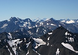
The Coast Mountains consist of a single uplifted mass. During the Pliocene period the Coast Mountains did not exist and a level peneplain extended to the sea. This mass was uplifted during the Miocene period. Rivers such as the Klinaklini River and Homathko River predate this uplift and due to erosion occurring faster than uplift, have continued to flow right up to the present day, directly across the axis of the range. The mountains flanking the Homathko River are the highest in the Coast Mountains, and include Mount Waddington west of the river in the Waddington Range and Mount Queen Bess east of the river, adjacent to the Homathko Icefield.

The Pacific Ranges in southwestern British Columbia are the southernmost subdivision of the Coast Mountains. It has been characterized by rapid rates of uplift over the past 4 million years unlike the North Cascades and has led to relatively high rates of erosion.

Insular Mountains

The Insular Mountains on the coast of British Columbia have not yet fully emerged above sea level, and Vancouver Island and Haida Gwaii are just the higher elevations of the range, which was in fact fully exposed during the last ice age when the continental shelf in this area was a broad coastal plain. Although the Coast Mountains are commonly considered to be the westernmost range of the American cordillera, the Insular Mountains are the true westernmost range.[13] Through the most recent ice age about 18,000 years ago, ice enclosed nearly all of the mountains. Glaciers that ran down to the Pacific Ocean sharpened the valley faces and eroded their bottoms.


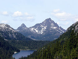
The Golden Hinde on Vancouver Island was formed by erosion carving into basalt.

The Insular Mountains were formed when a large island arc, called the Insular Islands, collided against North America during the Mid-Cretaceous period. The mountains are made of turbidite and pillow lavas unlike the plutons of the Coast Plutonic Complex that make the Coast Mountains. The Insular Mountains have much seismic activity, with the Juan de Fuca Plate subducting at the Cascadia subduction zone and the Pacific Plate sliding along the Queen Charlotte Fault. Large earthquakes have led to collapsing mountains, landslides, and the development of fissures.[14] Flood basalts on Vancouver Island form a geologic formation called the Karmutsen Formation, which is perhaps the thickest accreted section of an oceanic plateau worldwide, exposing up to 6,000 m (20,000 ft) of basal sediment-sill complexes, basaltic to picritic pillow lavas, pillow breccia, and thick, massive basalt flows.

Inequality (mathematics)

From Wikipedia, the free encyclopedia https://en.wikipedia.org/wiki/Inequality...