The possibility of life on Mars is a subject of significant interest to astrobiology due to its proximity and similarities to Earth. To date, no proof has been found of past or present life on Mars. Cumulative evidence shows that during the ancient Noachian time period, the surface environment of Mars had liquid water and may have been habitable for microorganisms. The existence of habitable conditions does not necessarily indicate the presence of life.
Scientific searches for evidence of life began in the 19th century, and they continue today via telescopic investigations and deployed probes. While early work focused on phenomenology and bordered on fantasy, the modern scientific inquiry has emphasized the search for water, chemical biosignatures in the soil and rocks at the planet's surface, and biomarker gases in the atmosphere.[1][2]
Mars is of particular interest for the study of the origins of life because of its similarity to the early Earth. This is especially so since Mars has a cold climate and lacks plate tectonics or continental drift, so it has remained almost unchanged since the end of the Hesperian period. At least two-thirds of Mars's surface is more than 3.5 billion years old, and Mars may thus hold the best record of the prebiotic conditions leading to abiogenesis, even if life does not or has never existed there.[3][4]
Following the confirmation of the past existence of surface liquid water, the Curiosity and Opportunity rovers started searching for evidence of past life, including a past biosphere based on autotrophic, chemotrophic, or chemolithoautotrophic microorganisms, as well as ancient water, including fluvio-lacustrine environments (plains related to ancient rivers or lakes) that may have been habitable.[5][6][7][8] The search for evidence of habitability, taphonomy (related to fossils), and organic compounds on Mars is now a primary NASA and ESA objective.
The findings of organic compounds inside sedimentary rocks and of boron on Mars are of interest as they are precursors for prebiotic chemistry. Such findings, along with previous discoveries that liquid water was clearly present on ancient Mars, further supports the possible early habitability of Gale Crater on Mars.[9][10] Currently, the surface of Mars is bathed with radiation, and when reacting with the perchlorates on the surface, it may be more toxic to microorganisms than thought earlier.[11][12] Therefore, the consensus is that if life exists —or existed— on Mars, it could be found or is best preserved in the subsurface, away from present-day harsh surface processes.
In June 2018 NASA announced the detection of seasonal variation of methane levels on Mars. Methane could be produced by microorganisms or by geological means.[13] The European ExoMars Trace Gas Orbiter started mapping the atmospheric methane in April 2018, and the 2020 ExoMars rover will drill and analyze subsurface samples, while the NASA Mars 2020 rover will cache dozens of drill samples for their potential transport to Earth laboratories in the late 2020s or 2030s.
Early speculation
Historical map of Mars from Giovanni Schiaparelli
Mars canals illustrated by astronomer Percival Lowell, 1898
Mars' polar ice caps were discovered in the mid-17th century. In the late 18th century, William Herschel proved they grow and shrink alternately, in the summer and winter of each hemisphere. By the mid-19th century, astronomers knew that Mars had certain other similarities to Earth, for example that the length of a day on Mars was almost the same as a day on Earth. They also knew that its axial tilt was similar to Earth's, which meant it experienced seasons just as Earth does — but of nearly double the length owing to its much longer year. These observations led to increase in speculation that the darker albedo features were water and the brighter ones were land, whence followed speculation on whether Mars may be inhabited by some form of life.
In 1854, William Whewell, a fellow of Trinity College, Cambridge, who popularized the word scientist, theorized that Mars had seas, land and possibly life forms.[14] Speculation about life on Mars exploded in the late 19th century, following telescopic observation by some observers of apparent Martian canals — which were later found to be optical illusions. Despite this, in 1895, American astronomer Percival Lowell published his book Mars, followed by Mars and its Canals in 1906,[15] proposing that the canals were the work of a long-gone civilization.[16] This idea led British writer H. G. Wells to write The War of the Worlds in 1897, telling of an invasion by aliens from Mars who were fleeing the planet's desiccation.
Spectroscopic analysis of Mars' atmosphere began in earnest in 1894, when U.S. astronomer William Wallace Campbell showed that neither water nor oxygen were present in the Martian atmosphere.[17] By 1909, better telescopes and the best perihelic opposition of Mars since 1877 conclusively put an end to the canal hypothesis.
Habitability
Chemical, physical, geological, and geographic attributes shape the environments on Mars. Isolated measurements of these factors may be insufficient to deem an environment habitable, but the sum of measurements can help predict locations with greater or lesser habitability potential.[18] The two current ecological approaches for predicting the potential habitability of the Martian surface use 19 or 20 environmental factors, with an emphasis on water availability, temperature, the presence of nutrients, an energy source, and protection from solar ultraviolet and galactic cosmic radiation.[19][20]Scientists do not know the minimum number of parameters for determination of habitability potential, but they are certain it is greater than one or two of the factors in the table below.[18] Similarly, for each group of parameters, the habitability threshold for each is to be determined.[18] Laboratory simulations show that whenever multiple lethal factors are combined, the survival rates plummet quickly.[21] There are no full-Mars simulations published yet that include all of the biocidal factors combined.[21]
| Habitability factors[20] | |
|---|---|
| Water | · liquid water activity (aw) · Past/future liquid (ice) inventories · Salinity, pH, and Eh of available water |
| Chemical environment | Nutrients: · C, H, N, O, P, S, essential metals, essential micronutrients · Fixed nitrogen · Availability/mineralogy Toxin abundances and lethality: · Heavy metals (e.g., Zn, Ni, Cu, Cr, As, Cd, etc., some essential, but toxic at high levels) · Globally distributed oxidizing soils |
| Energy for metabolism | Solar (surface and near-surface only) Geochemical (subsurface) · Oxidants · Reductants · Redox gradients |
| Conducive physical conditions |
· Temperature · Extreme diurnal temperature fluctuations · Low pressure (Is there a low-pressure threshold for terrestrial anaerobes?) · Strong ultraviolet germicidal irradiation · Galactic cosmic radiation and solar particle events (long-term accumulated effects) · Solar UV-induced volatile oxidants, e.g., O2−, O−, H2O2, O3 · Climate/variability (geography, seasons, diurnal, and eventually, obliquity variations) · Substrate (soil processes, rock microenvironments, dust composition, shielding) · High CO2 concentrations in the global atmosphere · Transport (aeolian, groundwater flow, surface water, glacial) |
Past
Recent models have shown that, even with a dense CO2 atmosphere, early Mars was colder than Earth has ever been.[22] Transiently warm conditions related to impacts or volcanism could have produced conditions favoring the formation of the late Noachian valley networks, even though the mid-late Noachian global conditions were probably icy. Local warming of the environment by volcanism and impacts would have been sporadic, but there should have been many events of water flowing at the surface of Mars.[22] Both the mineralogical and the morphological evidence indicates a degradation of habitability from the mid Hesperian onward. The exact causes are not well understood but may be related to a combination of processes including loss of early atmosphere, or impact erosion, or both.[22]
Alga crater is thought to have deposits of impact glass that may have preserved ancient biosignatures, if present during the impact.[23]
The loss of the Martian magnetic field strongly affected surface environments through atmospheric loss and increased radiation; this change significantly degraded surface habitability.[24] When there was a magnetic field, the atmosphere would have been protected from erosion by the solar wind, which would ensure the maintenance of a dense atmosphere, necessary for liquid water to exist on the surface of Mars.[25] The loss of the atmosphere was accompanied by decreasing temperatures. Part of the liquid water inventory sublimed and was transported to the poles, while the rest became trapped in permafrost, a subsurface ice layer.[22]
Observations on Earth and numerical modeling have shown that a crater-forming impact can result in the creation of a long-lasting hydrothermal system when ice is present in the crust. For example, a 130 km large crater could sustain an active hydrothermal system for up to 2 million years, that is, long enough for microscopic life to emerge,[22] but unlikely to have progressed any further down the evolutionary path.[26]
Soil and rock samples studied in 2013 by NASA's Curiosity rover's onboard instruments brought about additional information on several habitability factors.[27] The rover team identified some of the key chemical ingredients for life in this soil, including sulfur, nitrogen, hydrogen, oxygen, phosphorus and possibly carbon, as well as clay minerals, suggesting a long-ago aqueous environment — perhaps a lake or an ancient streambed — that had neutral acidity and not too salty.[27] On December 9, 2013, NASA reported that, based on evidence from Curiosity studying Aeolis Palus, Gale Crater contained an ancient freshwater lake which could have been a hospitable environment for microbial life.[28][29] The confirmation that liquid water once flowed on Mars, the existence of nutrients, and the previous discovery of a past magnetic field that protected the planet from cosmic and solar radiation,[30][31] together strongly suggest that Mars could have had the environmental factors to support life.[32][33] The assessment of past habitability is not in itself evidence that Martian life has ever actually existed. If it did, it was probably microbial, existing communally in fluids or on sediments, either free-living or as biofilms, respectively.[24]
Impactite, shown to preserve signs of life on Earth, was discovered on Mars and could contain signs of ancient life, if life ever existed on the planet.[34]
On June 7, 2018, NASA announced that the Curiosity rover had discovered organic molecules in sedimentary rocks dating to three billion years old.[35] [36] The detection of organic molecules in rocks indicate that some of the building blocks for life were present.[37][38]
Present
Conceivably, if life exists (or existed) on Mars, evidence of that life could be found, or is best preserved, in the subsurface, away from present-day harsh surface conditions.[39] Present-day life on Mars, or its biosignatures, could occur kilometers below the surface, or in subsurface geothermal hot spots, or it could occur a few meters below the surface. The permafrost layer on Mars is only a couple of centimeters below the surface, and salty brines can be liquid a few centimeters below that but not far down. Water is close to its boiling point even at the deepest points in the Hellas basin, and so cannot remain liquid for long on the surface of Mars in its present state, except when covered in ice or after a sudden release of underground water.So far, NASA has pursued a "follow the water" strategy on Mars and has not searched for biosignatures for life there directly since the Viking mission. As of 2017, the consensus by astrobiologists at NASA is that it may be necessary to access the Martian subsurface to find currently habitable environments.[39]
Dormant subsurface life
Curiosity measured ionizing radiation levels of 76 mGy a year.[40] This level of ionizing radiation is sterilizing for dormant life on the surface of Mars. It varies considerably in habitability depending on its orbital eccentricity and the tilt of its axis. If the surface life has been reanimated as recently as 450,000 years ago, then rovers on Mars could find dormant but still viable life at a depth of one meter below the surface, according to an estimate.[41]Cosmic radiation
In 1965, the Mariner 4 probe discovered that Mars had no global magnetic field that would protect the planet from potentially life-threatening cosmic radiation and solar radiation; observations made in the late 1990s by the Mars Global Surveyor confirmed this discovery.[42] Scientists speculate that the lack of magnetic shielding helped the solar wind blow away much of Mars's atmosphere over the course of several billion years.[43] As a result, the planet has been vulnerable to radiation from space for about 4 billion years.[44]Recent in-situ data from Curiosity rover indicates that ionizing radiation from galactic cosmic rays (GCR) and solar particle events (SPE) may not be a limiting factor in habitability assessments for present-day surface life on Mars. The level of 76 mGy per year measured by Curiosity is similar to levels inside the ISS.[45] In the 2014 Findings of the Second MEPAG Special Regions Science Analysis Group, their conclusion was:[46]
- "From MSL RAD measurements, ionizing radiation from galactic cosmic rays (GCR) at Mars is so low as to be negligible. Intermittent Solar particle events (SPE) can increase the atmospheric ionization down to ground level and increase the total dose, but these events are sporadic and last at most a few (2–5) days. These facts are not used to distinguish Special Regions on Mars." A Special Region is defined as a region on the Mars surface where Earth life could potentially survive.
Cumulative effects
Even the hardiest cells known could not possibly survive the cosmic radiation near the surface of Mars since Mars lost its protective magnetosphere and atmosphere.[47][48] After mapping cosmic radiation levels at various depths on Mars, researchers have concluded that over time, any life within the first several meters of the planet's surface would be killed by lethal doses of cosmic radiation.[47][49][50] The team calculated that the cumulative damage to DNA and RNA by cosmic radiation would limit retrieving viable dormant cells on Mars to depths greater than 7.5 meters below the planet's surface.[49] Even the most radiation-tolerant Earthly bacteria would survive in dormant spore state only 18,000 years at the surface; at 2 meters —the greatest depth at which the ExoMars rover will be capable of reaching— survival time would be 90,000 to half a million years, depending on the type of rock.[51]Data collected by the Radiation assessment detector (RAD) instrument on board the Curiosity rover revealed that the absorbed dose measured is 76 mGy/year at the surface,[52] and that "ionizing radiation strongly influences chemical compositions and structures, especially for water, salts, and redox-sensitive components such as organic molecules."[52] Regardless of the source of Martian organic compounds (meteoric, geological, or biological), its carbon bonds are susceptible to breaking and reconfiguring with surrounding elements by ionizing charged particle radiation.[52] These improved subsurface radiation estimates give insight into the potential for the preservation of possible organic biosignatures as a function of depth as well as survival times of possible microbial or bacterial life forms left dormant beneath the surface.[52] The report concludes that the in situ "surface measurements —and subsurface estimates— constrain the preservation window for Martian organic matter following exhumation and exposure to ionizing radiation in the top few meters of the Martian surface."[52]
In September 2017, NASA reported radiation levels on the surface of the planet Mars were temporarily doubled and were associated with an aurora 25 times brighter than any observed earlier, due to a major, and unexpected, solar storm in the middle of the month.[53]
UV radiation
On UV radiation, a 2014 report concludes [46] that "[T]he Martian UV radiation environment is rapidly lethal to unshielded microbes but can be attenuated by global dust storms and shielded completely by < 1 mm of regolith or by other organisms." In addition, laboratory research published in July 2017 demonstrated that when irradiated with a simulated Martian UV flux, perchlorates become bacteriocidal.[54]The penetration depth of UV radiation into soils is in the sub-millimeter to millimeter range and depends on the properties of the soil.[55]
Perchlorates
The Martian regolith is known to contain a maximum of 0.5% (w/v) perchlorate (ClO4−) that is toxic for most living organisms,[56] but since they drastically lower the freezing point of water and few extremophiles can use it as an energy source, it has prompted speculation of what their influence would be on habitability.[54][57][58]In July 2017 it was shown that when irradiated with a simulated Martian UV flux, perchlorates become bacteriocidal. Even dormant spores lost viability within minutes.[54] In addition, two other compounds of the Martian surface, iron oxides and hydrogen peroxide, act in synergy with irradiated perchlorates to cause a 10.8-fold increase in cell death when compared to cells exposed to UV radiation after 60 seconds of exposure.[54][55] It was also found that abraded silicates (quartz and basalt) lead to the formation of toxic reactive oxygen species.[59] The researchers concluded that "the surface of Mars is lethal to vegetative cells and renders much of the surface and near-surface regions uninhabitable."[60] This research demonstrates that the present-day surface is more uninhabitable than previously thought,[54][61] and reinforces the notion to inspect at least a few meters into the ground to ensure the levels of radiation would be relatively low.[61][62]
Recurrent slope lineae
Recurrent slope lineae (RSL) features form on Sun-facing slopes at times of the year when the local temperatures reach above the melting point for ice. The streaks grow in spring, widen in late summer and then fade away in autumn. This is hard to model in any other way except as involving liquid water in some form, though the streaks themselves are thought to be a secondary effect and not a direct indication of the dampness of the regolith. Although these features are now confirmed to involve liquid water in some form, the water could be either too cold or too salty for life. At present they are treated as potentially habitable, as "Uncertain Regions, to be treated as Special Regions".The 'Special Regions assessment' says of them:[46] "Although no single model currently proposed for the origin of RSL adequately explains all observations, they are currently best interpreted as being due to the seepage of water at > 250 K, with
 (water activity)
unknown and perhaps variable. As such they meet the criteria for
Uncertain Regions, to be treated as Special Regions. There are other
features on Mars with characteristics similar to RSL, but their
relationship to possible liquid water is much less likely." They were
first reported in 2011.[63]
They were already suspected as involving flowing brines back then, as
all the other models available involved liquid water in some form.[64][65][66][67]
(water activity)
unknown and perhaps variable. As such they meet the criteria for
Uncertain Regions, to be treated as Special Regions. There are other
features on Mars with characteristics similar to RSL, but their
relationship to possible liquid water is much less likely." They were
first reported in 2011.[63]
They were already suspected as involving flowing brines back then, as
all the other models available involved liquid water in some form.[64][65][66][67]The thermodynamic availability of water (water activity) strictly limits microbial propagation on Earth, particularly in hypersaline environments, and there are indications that the brine ionic strength is a barrier to the habitability of Mars. Experiments show that high ionic strength, driven to extremes on Mars by the ubiquitous occurrence of divalent ions, "renders these environments uninhabitable despite the presence of biologically available water."[68]
Nitrogen fixation
After carbon, nitrogen is arguably the most important element needed for life. Thus, measurements of nitrate over the range of 0.1% to 5% are required to address the question of its occurrence and distribution. There is nitrogen (as N2) in the atmosphere at low levels, but this is not adequate to support nitrogen fixation for biological incorporation.[69] Nitrogen in the form of nitrate could be a resource for human exploration both as a nutrient for plant growth and for use in chemical processes. On Earth, nitrates correlate with perchlorates in desert environments, and this may also be true on Mars. Nitrate is expected to be stable on Mars and to have formed by thermal shock from impact or volcanic plume lightning on ancient Mars.[70]On 24 March 2015, NASA reported that the SAM instrument on the Curiosity rover detected nitrates by heating surface sediments. The nitrogen in nitrate is in a "fixed" state, meaning that it is in an oxidized form that can be used by living organisms. The discovery supports the notion that ancient Mars may have been hospitable for life.[70][71][72] It is suspected that all nitrate on Mars is a relic, with no modern contribution.[73] Nitrate abundance ranges from non-detection to 681 ± 304 mg/kg in the samples examined until late 2017.[73] Modeling indicates that the transient condensed water films on the surface should be transported to lower depths (≈10 m) potentially transporting nitrates, where subsurface microorganisms could thrive.[74]
In contrast, phosphate, one of the chemical nutrients thought to be essential for life, is readily available on Mars.[75]
Low pressure
Further complicating estimates of the habitability of the Martian surface is the fact that very little is known about the growth of microorganisms at pressures close to those on the surface of Mars. Some teams determined that some bacteria may be capable of cellular replication down to 25 mbar, but that is still above the atmospheric pressures found on Mars (range 1–14 mbar).[76] In another study, twenty-six strains of bacteria were chosen based on their recovery from spacecraft assembly facilities, and only Serratia liquefaciens strain ATCC 27592 exhibited growth at 7 mbar, 0 °C, and CO2-enriched anoxic atmospheres.[76]Liquid water
Liquid water is a necessary but not sufficient condition for life as we know it, as habitability is a function of a multitude of environmental parameters.[77] Liquid water cannot exist on the surface of Mars except at the lowest elevations for minutes or hours.[78][79] Liquid water does not appear at the surface itself,[80] but it could form in minuscule amounts around dust particles in snow heated by the Sun.[81][82] Also, the ancient equatorial ice sheets beneath the ground may slowly sublimate or melt, accessible from the surface via caves.[83][84][85][86]
A series of artist's conceptions of past water coverage on Mars
It has been estimated that the primordial oceans on Mars would have covered between 36%[103] and 75% of the planet.[104] On November 22, 2016, NASA reported finding a large amount of underground ice in the Utopia Planitia region of Mars. The volume of water detected has been estimated to be equivalent to the volume of water in Lake Superior.[87][88][89]
Analysis of Martian sandstones, using data obtained from orbital spectrometry, suggests that the waters that previously existed on the surface of Mars would have had too high a salinity to support most Earth-like life. Tosca et al. found that the Martian water in the locations they studied all had water activity, aw ≤ 0.78 to 0.86—a level fatal to most Terrestrial life.[105] Haloarchaea, however, are able to live in hypersaline solutions, up to the saturation point.[106]
In June 2000, possible evidence for current liquid water flowing at the surface of Mars was discovered in the form of flood-like gullies.[107][108] Additional similar images were published in 2006, taken by the Mars Global Surveyor, that suggested that water occasionally flows on the surface of Mars. The images showed changes in steep crater walls and sediment deposits, providing the strongest evidence yet that water coursed through them as recently as several years ago.
There is disagreement in the scientific community as to whether or not the recent gully streaks were formed by liquid water. Some suggest the flows were merely dry sand flows.[109][110][111][112] Others suggest it may be liquid brine near the surface,[113][114][115] but the exact source of the water and the mechanism behind its motion are not understood.[116]
Silica
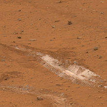
The silica-rich patch discovered by Spirit rover
In May 2007, the Spirit rover disturbed a patch of ground with its inoperative wheel, uncovering an area 90% rich in silica.[117] The feature is reminiscent of the effect of hot spring water or steam coming into contact with volcanic rocks. Scientists consider this as evidence of a past environment that may have been favorable for microbial life and theorize that one possible origin for the silica may have been produced by the interaction of soil with acid vapors produced by volcanic activity in the presence of water.[118]
Based on Earth analogs, hydrothermal systems on Mars would be highly attractive for their potential for preserving organic and inorganic biosignatures.[119][120][121] For this reason, hydrothermal deposits are regarded as important targets in the exploration for fossil evidence of ancient Martian life.[122][123][124]
Possible biosignatures
In May 2017, evidence of the earliest known life on land on Earth may have been found in 3.48-billion-year-old geyserite and other related mineral deposits (often found around hot springs and geysers) uncovered in the Pilbara Craton of Western Australia.[125][126] These findings may be helpful in deciding where best to search for early signs of life on the planet Mars.[125][126]Methane
Possible trace amounts of methane in the atmosphere of Mars were first discovered in 2003 with Earth-based telescopes and fully verified in 2004 by the ESA Mars Express spacecraft in orbit around Mars.[127][128][129][130][131][132] As methane is an unstable gas, its presence indicates that there must be an active source on the planet in order to keep such levels in the atmosphere. It is estimated that Mars must produce 270 ton/year of methane,[133][134] but asteroid impacts account for only 0.8% of the total methane production. Although geologic sources of methane such as serpentinization are possible, the lack of current volcanism, hydrothermal activity or hotspots[135] are not favorable for geologic methane. It has been suggested that the methane was produced by chemical reactions in meteorites, driven by the intense heat during entry through the atmosphere. Although research published in December 2009 ruled out this possibility,[136] research published in 2012 suggest that a source may be organic compounds on meteorites that are converted to methane by ultraviolet radiation.[137]The existence of life in the form of microorganisms such as methanogens is among possible but as yet unproven sources. Methanogens do not require oxygen or organic nutrients, are non-photosynthetic, use hydrogen as their energy source and carbon dioxide (CO2) as their carbon source, so they could exist in subsurface environments on Mars.[138] If microscopic Martian life is producing the methane, it probably resides far below the surface, where it is still warm enough for liquid water to exist.[139]
Since the 2003 discovery of methane in the atmosphere, some scientists have been designing models and in vitro experiments testing the growth of methanogenic bacteria on simulated Martian soil, where all four methanogen strains tested produced substantial levels of methane, even in the presence of 1.0wt% perchlorate salt.[140] The results reported indicate that the perchlorates discovered by the Phoenix Lander would not rule out the possible presence of methanogens on Mars.[140][141]
A team led by Levin suggested that both phenomena—methane production and degradation—could be accounted for by an ecology of methane-producing and methane-consuming microorganisms.[141][142]
Research at the University of Arkansas presented in June 2015 suggested that some methanogens could survive on Mars's low pressure. Rebecca Mickol found that in her laboratory, four species of methanogens survived low-pressure conditions that were similar to a subsurface liquid aquifer on Mars. The four species that she tested were Methanothermobacter wolfeii, Methanosarcina barkeri, Methanobacterium formicicum, and Methanococcus maripaludis.[138] In June 2012, scientists reported that measuring the ratio of hydrogen and methane levels on Mars may help determine the likelihood of life on Mars.[143][144] According to the scientists, "...low H2/CH4 ratios (less than approximately 40) indicate that life is likely present and active."[143] Other scientists have recently reported methods of detecting hydrogen and methane in extraterrestrial atmospheres.[145][146]
The Curiosity rover, which landed on Mars in August 2012, is able to make measurements that distinguish between different isotopologues of methane, and in 2014, Curiosity detected a "tenfold spike" in the level of methane in the Martian atmosphere compared to the usual background readings.[147][148][149] Even if the mission is to determine that microscopic Martian life is the seasonal source of the methane, the life forms probably reside far below the surface, outside of the rover's reach.[150] The first measurements with the Tunable Laser Spectrometer (TLS) in the Curiosity rover indicated that there is less than 5 ppb of methane at the landing site at the point of the measurement.[151][152][153][154] On July 19, 2013, NASA scientists published the results of a new analysis of the atmosphere of Mars, reporting a lack of methane around the landing site of the Curiosity rover.[155][156][157] On September 19, 2013, NASA again reported no detection of atmospheric methane with a measured value of 0.18±0.67 ppbv corresponding to an upper limit of only 1.3 ppbv (95% confidence limit) and, as a result, concluded that the probability of current methanogenic microbial activity on Mars is reduced.[158][159][160] On 16 December 2014, NASA reported that Curiosity had detected a tenfold increase ('spike') in methane in the atmosphere around it in late 2013 and early 2014. Four measurements taken over two months in this period averaged 7 ppb, suggesting that methane is released at intervals.[147][148][161]
On June 7, 2018, NASA announced it has detected a seasonal variation of methane levels on Mars.[13] Chris Webster, a senior researcher at Jet Propulsion Laboratory says, "Not only have we got this wonderful repeatability, but the seasonal cycle changes by a factor of three. That's a huge change, completely unexpected. And what it does, it gives us a key to unlocking the mysteries associated with Mars methane because now we have something to test our models and our understanding against." Methane lasts only a few centuries before it is broken down. He also says "...so if we see methane in the martian atmosphere, that means something is happening today, it's being released or it's being created."[162][37][38][163][164][165][36]
The ExoMars Trace Gas Orbiter, launched in March 2016, began on 21 April 2018 to map the concentration and sources of methane in the atmosphere,[166][167] as well as its decomposition products such as formaldehyde and methanol.
Formaldehyde
In February 2005, it was announced that the Planetary Fourier Spectrometer (PFS) on the European Space Agency's Mars Express Orbiter had detected traces of formaldehyde in the atmosphere of Mars. Vittorio Formisano, the director of the PFS, has speculated that the formaldehyde could be the byproduct of the oxidation of methane and, according to him, would provide evidence that Mars is either extremely geologically active or harboring colonies of microbial life.[168][169] NASA scientists consider the preliminary findings well worth a follow-up but have also rejected the claims of life.[170][171]Viking lander biological experiments
The 1970s Viking program placed two identical landers on the surface of Mars tasked to look for biosignatures of microbial life on the surface. Of the four experiments performed by each Viking lander, only the 'Labeled Release' (LR) experiment gave a positive result for metabolism, while the other three did not detect organic compounds. The LR was a specific experiment designed to test only a narrowly defined critical aspect of the theory concerning the possibility of life on Mars; therefore, the overall results were declared inconclusive.[17] No Mars lander mission has found meaningful traces of biomolecules or biosignatures. The claim of extant microbial life on Mars is based on old data collected by the Viking landers, currently reinterpreted as sufficient evidence of life, mainly by Gilbert Levin,[172] Joseph D. Miller,[173] Navarro,[174] Giorgio Bianciardi and Patricia Ann Straat,[175] that the Viking LR experiments detected extant microbial life on Mars.Assessments published in December 2010 by Rafael Navarro–Gonzáles[176][177][178][179] indicate that organic compounds "could have been present" in the soil analyzed by both Viking 1 and 2. The study determined that perchlorate —discovered in 2008 by Phoenix lander[180][181]— can destroy organic compounds when heated, and produce chloromethane and dichloromethane as a byproduct, the identical chlorine compounds discovered by both Viking landers when they performed the same tests on Mars. Because perchlorate would have broken down any Martian organics, the question of whether or not Viking found organic compounds is still wide open.[182][183]
The Labeled Release evidence was not generally accepted initially, and, to this day lacks the consensus of the scientific community.[184]
Curiosity rover sediment sampling
In June 2018, NASA reported that the Curiosity rover had found evidence of complex organic compounds from mudstone rocks aged approximately 3.5 billion years old, sampled from two distinct sites in a dry lake in the Pahrump Hills of the Gale crater. The rock samples, when pyrolyzed via the Curiosity's Sample Analysis at Mars instrument, released an array of organic molecules; these include sulfur-containing thiophenes, aromatic compounds such as benzene and toluene, and aliphatic compounds such as propane and butene. The concentration of organic compounds is 100-fold higher than earlier measurements. The authors speculate that the presence of sulfur may have helped preserve them. The products resemble those obtained from the breakdown of kerogen, a precursor to oil and natural gas on Earth. NASA stated that these findings are not evidence that life existed on the planet, but that the organic compounds needed to sustain microscopic life were present and there may be deeper sources of organic compounds on the planet.[185][38][163][164][165][36][13]Meteorites
There are 34 known Martian meteorites (some of which were found in several fragments).[186] These are valuable because they are the only physical samples of Mars available to Earth-bound laboratories. Some researchers have argued that microscopic morphological features found in ALH84001 are biomorphs, however this interpretation has been highly controversial and is not supported by the majority of researchers in the field.[187]Seven criteria have been established for the recognition of past life within terrestrial geologic samples. Those criteria are:[187]
- Is the geologic context of the sample compatible with past life?
- Is the age of the sample and its stratigraphic location compatible with possible life?
- Does the sample contain evidence of cellular morphology and colonies?
- Is there any evidence of biominerals showing chemical or mineral disequilibria?
- Is there any evidence of stable isotope patterns unique to biology?
- Are there any organic biomarkers present?
- Are the features indigenous to the sample?
ALH84001
An electron microscope reveals bacteria-like structures in meteorite fragment ALH84001
In 1996, the Martian meteorite ALH84001, a specimen that is much older than the majority of Martian meteorites that have been recovered so far, received considerable attention when a group of NASA scientists led by David S. McKay reported microscopic features and geochemical anomalies that they considered to be best explained by the rock having hosted Martian bacteria in the distant past. Some of these features resembled terrestrial bacteria, aside from their being much smaller than any known form of life. Much controversy arose over this claim, and ultimately all of the evidence McKay's team cited as evidence of life was found to be explainable by non-biological processes. Although the scientific community has largely rejected the claim ALH 84001 contains evidence of ancient Martian life, the controversy associated with it is now seen as a historically significant moment in the development of exobiology.[188][189]
Nakhla meteorite
Nakhla
The Nakhla meteorite fell on Earth on June 28, 1911, on the locality of Nakhla, Alexandria, Egypt.[190][191]In 1998, a team from NASA's Johnson Space Center obtained a small sample for analysis. Researchers found preterrestrial aqueous alteration phases and objects[192] of the size and shape consistent with Earthly fossilized nanobacteria. Analysis with gas chromatography and mass spectrometry (GC-MS) studied its high molecular weight polycyclic aromatic hydrocarbons in 2000, and NASA scientists concluded that as much as 75% of the organic compounds in Nakhla "may not be recent terrestrial contamination".[187][193]
This caused additional interest in this meteorite, so in 2006, NASA managed to obtain an additional and larger sample from the London Natural History Museum. On this second sample, a large dendritic carbon content was observed. When the results and evidence were published in 2006, some independent researchers claimed that the carbon deposits are of biologic origin. It was remarked that since carbon is the fourth most abundant element in the Universe, finding it in curious patterns is not indicative or suggestive of biological origin.[194][195]
Shergotty
The Shergotty meteorite, a 4 kg Martian meteorite, fell on Earth on Shergotty, India on August 25, 1865, and was retrieved by witnesses almost immediately.[196] It is composed mostly of pyroxene and thought to have undergone preterrestrial aqueous alteration for several centuries. Certain features in its interior suggest remnants of a biofilm and its associated microbial communities.[187] Work is in progress on searching for magnetites within alteration phases.Yamato 000593
Yamato 000593 is the second largest meteorite from Mars found on Earth. Studies suggest the Martian meteorite was formed about 1.3 billion years ago from a lava flow on Mars. An impact occurred on Mars about 12 million years ago and ejected the meteorite from the Martian surface into space. The meteorite landed on Earth in Antarctica about 50,000 years ago. The mass of the meteorite is 13.7 kg (30 lb) and it has been found to contain evidence of past water movement.[197][198][199] At a microscopic level, spheres are found in the meteorite that are rich in carbon compared to surrounding areas that lack such spheres. The carbon-rich spheres may have been formed by biotic activity according to NASA scientists.[197][198][199]Geysers on Mars
The seasonal frosting and defrosting of the southern ice cap results in the formation of spider-like radial channels carved on 1-meter thick ice by sunlight. Then, sublimed CO2 – and probably water – increase pressure in their interior producing geyser-like eruptions of cold fluids often mixed with dark basaltic sand or mud.[200][201][202][203] This process is rapid, observed happening in the space of a few days, weeks or months, a growth rate rather unusual in geology – especially for Mars.
A team of Hungarian scientists proposes that the geysers' most visible features, dark dune spots and spider channels, may be colonies of photosynthetic Martian microorganisms, which over-winter beneath the ice cap, and as the sunlight returns to the pole during early spring, light penetrates the ice, the microorganisms photosynthesize and heat their immediate surroundings. A pocket of liquid water, which would normally evaporate instantly in the thin Martian atmosphere, is trapped around them by the overlying ice. As this ice layer thins, the microorganisms show through grey. When the layer has completely melted, the microorganisms rapidly desiccate and turn black, surrounded by a grey aureole.[204][205][206] The Hungarian scientists believe that even a complex sublimation process is insufficient to explain the formation and evolution of the dark dune spots in space and time.[207][208] Since their discovery, fiction writer Arthur C. Clarke promoted these formations as deserving of study from an astrobiological perspective.[209]
A multinational European team suggests that if liquid water is present in the spiders' channels during their annual defrost cycle, they might provide a niche where certain microscopic life forms could have retreated and adapted while sheltered from solar radiation.[210] A British team also considers the possibility that organic matter, microbes, or even simple plants might co-exist with these inorganic formations, especially if the mechanism includes liquid water and a geothermal energy source.[211] They also remark that the majority of geological structures may be accounted for without invoking any organic "life on Mars" hypothesis.[211] It has been proposed to develop the Mars Geyser Hopper lander to study the geysers up close.[212]
Forward contamination
Planetary protection of Mars aims to prevent biological contamination of the planet.[213] A major goal is to preserve the planetary record of natural processes by preventing human-caused microbial introductions, also called forward contamination. There is abundant evidence as to what can happen when organisms from regions on Earth that have been isolated from one another for significant periods of time are introduced into each other's environment. Species that are constrained in one environment can thrive – often out of control – in another environment much to the detriment of the original species that were present. In some ways, this problem could be compounded if life forms from one planet were introduced into the totally alien ecology of another world.[214]The prime concern of hardware contaminating Mars derives from incomplete spacecraft sterilization of some hardy terrestrial bacteria (extremophiles) despite best efforts.[20][215] Hardware includes landers, crashed probes, end-of-mission disposal of hardware, and the hard landing of entry, descent, and landing systems. This has prompted research on survival rates of radiation-resistant microorganisms including the species Deinococcus radiodurans and genera Brevundimonas, Rhodococcus, and Pseudomonas under simulated Martian conditions.[216] Results from one of these experimental irradiation experiments, combined with previous radiation modeling, indicate that Brevundimonas sp. MV.7 emplaced only 30 cm deep in Martian dust could survive the cosmic radiation for up to 100,000 years before suffering 10⁶ population reduction.[216] The diurnal Mars-like cycles in temperature and relative humidity affected the viability of Deinococcus radiodurans cells quite severely.[217] In other simulations, Deinococcus radiodurans also failed to grow under low atmospheric pressure, under 0 °C, or in the absence of oxygen.[218]
Survival under simulated Martian conditions
On 26 April 2012, scientists reported that an extremophile lichen survived and showed remarkable results on the adaptation capacity of photosynthetic activity within the simulation time of 34 days under Martian conditions in the Mars Simulation Laboratory (MSL) maintained by the German Aerospace Center (DLR).[219][220][221][222][223][224] The ability to survive in an environment is not the same as the ability to thrive, reproduce, and evolve in that same environment, necessitating further study.Although numerous studies point to resistance to some of Mars conditions, they do so separately, and none has considered the full range of Martian surface conditions, including temperature, pressure, atmospheric composition, radiation, humidity, oxidizing regolith, and others, all at the same time and in combination.[225] Laboratory simulations show that whenever multiple lethal factors are combined, the survival rates plummet quickly.[21]
Missions
Mars-2
Mars-1 was the first spacecraft launched to Mars in 1962,[226] but communication was lost while en route to Mars. With Mars-2 and Mars-3 in 1971-1972, information was obtained on the nature of the surface rocks and altitude profiles of the surface density of the soil, its thermal conductivity, and thermal anomalies detected on the surface of Mars. The program found that its northern polar cap has a temperature below -110 °C and that the water vapor content in the atmosphere of Mars is five thousand times less than on Earth. No signs of life were found.[227]Mariner 4
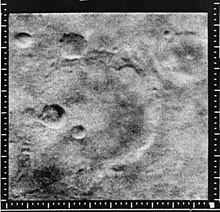
Mariner Crater, as seen by Mariner 4 in 1965. Pictures like this suggested that Mars is too dry for any kind of life.
Streamlined Islands seen by Viking orbiter showed that large floods occurred on Mars. The image is located in Lunae Palus quadrangle.
Mariner 4 probe performed the first successful flyby of the planet Mars, returning the first pictures of the Martian surface in 1965. The photographs showed an arid Mars without rivers, oceans, or any signs of life. Further, it revealed that the surface (at least the parts that it photographed) was covered in craters, indicating a lack of plate tectonics and weathering of any kind for the last 4 billion years. The probe also found that Mars has no global magnetic field that would protect the planet from potentially life-threatening cosmic rays. The probe was able to calculate the atmospheric pressure on the planet to be about 0.6 kPa (compared to Earth's 101.3 kPa), meaning that liquid water could not exist on the planet's surface.[17] After Mariner 4, the search for life on Mars changed to a search for bacteria-like living organisms rather than for multicellular organisms, as the environment was clearly too harsh for these.
Viking orbiters
Liquid water is necessary for known life and metabolism, so if water was present on Mars, the chances of it having supported life may have been determinant. The Viking orbiters found evidence of possible river valleys in many areas, erosion and, in the southern hemisphere, branched streams.[228][229][230]Viking experiments

Carl Sagan poses next to a replica of the Viking landers.
The primary mission of the Viking probes of the mid-1970s was to carry out experiments designed to detect microorganisms in Martian soil because the favorable conditions for the evolution of multicellular organisms ceased some four billion years ago on Mars.[231] The tests were formulated to look for microbial life similar to that found on Earth. Of the four experiments, only the Labeled Release (LR) experiment returned a positive result,[dubious ] showing increased 14CO2 production on first exposure of soil to water and nutrients. All scientists agree on two points from the Viking missions: that radiolabeled 14CO2 was evolved in the Labeled Release experiment, and that the GCMS detected no organic molecules. There are vastly different interpretations of what those results imply.
A 2011 astrobiology textbook notes that the GCMS was the decisive factor due to which "For most of the Viking scientists, the final conclusion was that the Viking missions failed to detect life in the Martian soil."[232]
One of the designers of the Labeled Release experiment, Gilbert Levin, believes his results are a definitive diagnostic for life on Mars.[17] Levin's interpretation is disputed by many scientists.[233] A 2006 astrobiology textbook noted that "With unsterilized Terrestrial samples, though, the addition of more nutrients after the initial incubation would then produce still more radioactive gas as the dormant bacteria sprang into action to consume the new dose of food. This was not true of the Martian soil; on Mars, the second and third nutrient injections did not produce any further release of labeled gas."[234] Other scientists argue that superoxides in the soil could have produced this effect without life being present.[235] An almost general consensus discarded the Labeled Release data as evidence of life, because the gas chromatograph and mass spectrometer, designed to identify natural organic matter, did not detect organic molecules.[172] More recently, high levels of organic chemicals, particularly chlorobenzene, were detected in powder drilled from one of the rocks, named "Cumberland", analyzed by the Curiosity rover.[147][148] The results of the Viking mission concerning life are considered by the general expert community as inconclusive.[17][235][236]
In 2007, during a Seminar of the Geophysical Laboratory of the Carnegie Institution (Washington, D.C., US), Gilbert Levin's investigation was assessed once more.[172] Levin still maintains that his original data were correct, as the positive and negative control experiments were in order.[175] Moreover, Levin's team, on 12 April 2012, reported a statistical speculation, based on old data —reinterpreted mathematically through cluster analysis— of the Labeled Release experiments, that may suggest evidence of "extant microbial life on Mars."[175][237] Critics counter that the method has not yet been proven effective for differentiating between biological and non-biological processes on Earth so it is premature to draw any conclusions.[238]
A research team from the National Autonomous University of Mexico headed by Rafael Navarro-González concluded that the GCMS equipment (TV-GC-MS) used by the Viking program to search for organic molecules, may not be sensitive enough to detect low levels of organics.[179] Klaus Biemann, the principal investigator of the GCMS experiment on Viking wrote a rebuttal.[239] Because of the simplicity of sample handling, TV–GC–MS is still considered the standard method for organic detection on future Mars missions, so Navarro-González suggests that the design of future organic instruments for Mars should include other methods of detection.
After the discovery of perchlorates on Mars by the Phoenix lander, practically the same team of Navarro-González published a paper arguing that the Viking GCMS results were compromised by the presence of perchlorates.[240] A 2011 astrobiology textbook notes that "while perchlorate is too poor an oxidizer to reproduce the LR results (under the conditions of that experiment perchlorate does not oxidize organics), it does oxidize, and thus destroy, organics at the higher temperatures used in the Viking GCMS experiment."[241] Biemann has written a commentary critical of this Navarro-González paper as well,[242] to which the latter have replied;[243] the exchange was published in December 2011.
Phoenix lander, 2008

An artist's concept of the Phoenix spacecraft
The Phoenix mission landed a robotic spacecraft in the polar region of Mars on May 25, 2008 and it operated until November 10, 2008. One of the mission's two primary objectives was to search for a "habitable zone" in the Martian regolith where microbial life could exist, the other main goal being to study the geological history of water on Mars. The lander has a 2.5 meter robotic arm that was capable of digging shallow trenches in the regolith. There was an electrochemistry experiment which analysed the ions in the regolith and the amount and type of antioxidants on Mars. The Viking program data indicate that oxidants on Mars may vary with latitude, noting that Viking 2 saw fewer oxidants than Viking 1 in its more northerly position. Phoenix landed further north still.[244] Phoenix's preliminary data revealed that Mars soil contains perchlorate, and thus may not be as life-friendly as thought earlier.[245][246][247] The pH and salinity level were viewed as benign from the standpoint of biology. The analysers also indicated the presence of bound water and CO2.[248] A recent analysis of Martian meteorite EETA79001 found 0.6 ppm ClO4−, 1.4 ppm ClO3−, and 16 ppm NO3−, most likely of Martian origin. The ClO3− suggests presence of other highly oxidizing oxychlorines such as ClO2− or ClO, produced both by UV oxidation of Cl and X-ray radiolysis of ClO4−. Thus only highly refractory and/or well-protected (sub-surface) organics are likely to survive.[249] In addition, recent analysis of the Phoenix WCL showed that the Ca(ClO4)2 in the Phoenix soil has not interacted with liquid water of any form, perhaps for as long as 600 Myr. If it had, the highly soluble Ca(ClO4)2 in contact with liquid water would have formed only CaSO4. This suggests a severely arid environment, with minimal or no liquid water interaction.[250]
Curiosity rover self-portrait.
Mars Science Laboratory
The Mars Science Laboratory mission is a NASA project that launched on November 26, 2011, the Curiosity rover, a nuclear-powered robotic vehicle, bearing instruments designed to assess past and present habitability conditions on Mars.[251][252] The Curiosity rover landed on Mars on Aeolis Palus in Gale Crater, near Aeolis Mons (a.k.a. Mount Sharp),[253][254][255][256] on August 6, 2012.[257][258][259]On 16 December 2014, NASA reported the Curiosity rover detected a "tenfold spike", likely localized, in the amount of methane in the Martian atmosphere. Sample measurements taken "a dozen times over 20 months" showed increases in late 2013 and early 2014, averaging "7 parts of methane per billion in the atmosphere." Before and after that, readings averaged around one-tenth that level.[147][148] In addition, low levels of chlorobenzene (C
6H
5Cl), were detected in powder drilled from one of the rocks, named "Cumberland", analyzed by the Curiosity rover.[147][148]
Future astrobiology missions
- ExoMars is a European-led multi-spacecraft programme currently under development by the European Space Agency (ESA) and the Russian Federal Space Agency for launch in 2016 and 2020.[261] Its primary scientific mission will be to search for possible biosignatures on Mars, past or present. A rover with a 2 m (6.6 ft) core drill will be used to sample various depths beneath the surface where liquid water may be found and where microorganisms (or organic biosignatures[citation needed]) might survive cosmic radiation.[32]
- Mars 2020 – The Mars 2020 rover is a Mars planetary rover mission by NASA with a planned launch in 2020. It is intended to investigate an astrobiologically relevant ancient environment on Mars, investigate its surface geological processes and history, including the assessment of its past habitability and potential for preservation of biosignatures within accessible geological materials.[262]
- Mars Sample Return Mission — The best life detection experiment proposed is the examination on Earth of a soil sample from Mars. However, the difficulty of providing and maintaining life support over the months of transit from Mars to Earth remains to be solved. Providing for still unknown environmental and nutritional requirements is daunting. Should dead organisms be found in a sample, it would be difficult to conclude that those organisms were alive when obtained.







 NASA
NASA
 NASA, ESA and G. Bacon (STScI)
 Contemporary Physics Education Project / DOE / NSF / LBNL
 PoorLeno / Wikimedia Commons
 APS/Alan Stonebraker
 CXC/M. Weiss
 ESO/Luís Calçada
 Brookhaven National Laboratory
 The quark-confinement-induced pressure distribution in the proton by V.D. Burkert, L. Elouadrhiri, and F.X. Girod
 LIGO-Virgo/Frank Elavsky/Northwestern
