Search This Blog

Wednesday, September 29, 2021

Impact winter

From Wikipedia, the free encyclopedia

An impact winter is a hypothesized period of prolonged cold weather due to the impact of a large asteroid or comet on the Earth's surface. If an asteroid were to strike land or a shallow body of water, it would eject an enormous amount of dust, ash, and other material into the atmosphere, blocking the radiation from the Sun. This would cause the global temperature to decrease drastically. If an asteroid or comet with the diameter of about 5 km (3.1 mi) or more were to hit in a large deep body of water or explode before hitting the surface, there would still be an enormous amount of debris ejected into the atmosphere. It has been proposed that an impact winter could lead to mass extinction, wiping out many of the world's existing species. The Cretaceous–Paleogene extinction event probably involved an impact winter, and led to mass extinction of most tetrapods weighing more than 25 kilograms (55 pounds).

Possibility of impact

Each year, the Earth is hit by 5 m (16 ft) diameter meteoroids that deliver an explosion 50 km (31 mi) above the surface with the power equivalent of one kiloton TNT. The Earth is hit every day by a meteor less than 5 m (16 ft) in diameter, that disintegrates before reaching the surface. The meteors that do make it to the surface tend to strike unpopulated areas, and cause no harm. A human is more likely to die in a fire, flood, or other natural disaster than to die because of an asteroid or comet impact. Another study in 1994 found a 1 in 10,000 chance that the Earth will be hit by a large asteroid or comet with a diameter of about 2 km (1.2 mi) during the next century. This object would be capable of disrupting the ecosphere and would kill a large fraction of the world's population. One such object, Asteroid 1950 DA, currently has a 0.005% chance of colliding with Earth in the year 2880, though when first discovered the probability was 0.3%. The probability goes down as orbits are refined with additional measurements.

In addition there are over 300 short period comets which pass near larger planets, such as Saturn and Jupiter, which can change the trajectory and could potentially put them into an Earth-crossing orbit. This could happen for long period comets also but the chance is highest for short period comets. The chance of these directly impacting Earth is far lower than a near-Earth object (NEO) impact. Victor Clube and Bill Napier support a controversial theory that a short period comet in an Earth crossing orbit doesn't need to impact to be hazardous, as it could disintegrate and cause a dust veil with possibilities of a "nuclear winter" scenario with long term global cooling lasting for thousands of years (which they consider to be similar in probability to a 1 km impact).

Necessary impact factors

The Earth experiences a never ending barrage of cosmic debris. Small particles burn up as they enter the atmosphere and are visible as meteors. Many of them go unnoticed by the average person even though not all of them burn up before they hit the Earth's surface. Those that strike the surface are known as meteorites. Thus, not every object that hits the Earth will cause an extinction level event or even cause any real harm. Objects release most of their kinetic energy in the atmosphere and will explode if they experience a column of atmosphere greater than or equal to their mass. Extinction sized impacts on the Earth occur about every 100 million years. Although extinction events happen very rarely, large projectiles can do severe damage. This section will discuss the nature of the hazards posed by projectiles as a function of their size and composition.

Size

A large asteroid or comet could collide with the Earth's surface with the force of hundreds to thousands of times the force of all the nuclear bombs on the Earth. For example, the K/T boundary impact has been proposed to have caused extinction of all non-avian dinosaurs 66 million years ago. Early estimates of this asteroid's size put it at about 10 km (6.2 mi) in diameter. This means it hit with nearly a force of 100,000,000 MT (418 ZJ). That is over six billion times larger than the atomic bomb yield (16 kilotons, 67 TJ) that was dropped on Hiroshima during WW2. This impactor excavated the Chicxulub crater that is 180 km (110 mi) in diameter. With an object this size, dust and debris would still be ejected into the atmosphere even if it hit the ocean, which is only 4 km (2.5 mi) deep. An asteroid, meteor, or comet would remain intact through the atmosphere by virtue of its sheer mass. However, an object smaller than 3 km (1.9 mi) would have to have a strong iron composition to breach the lower atmosphere - the troposphere or the lower levels of the stratosphere.

Composition

There are three different composition types for an asteroid or comet: metallic, stony and icy. The composition of the object determines whether or not it will make it to the Earth's surface in one piece, disintegrate before breaching the atmosphere, or break up and explode just before reaching the surface. A metallic object tends to be made up of iron and nickel alloys. These metallic objects are the most likely to impact the surface because they stand up better to the stresses of ram pressure induced flattening and fragmentation during deceleration in the atmosphere. The stony objects, like chondritic meteorites, tend to burn, break up, or explode before leaving the upper atmosphere. Those that do make it to the surface need a minimum energy of about 10 MT or about 50 m (160 ft) diameter to breach the lower atmosphere (this is for a stony object hitting at 20 km/s). The porous comet-like objects are made up of low-density silicates, organics, ice, volatile and often burn up in the upper atmosphere because of their low bulk density (≤1 g/cm3).

Possible mechanisms

Although the asteroids and comets that impact the Earth hit with many times the explosive force of a volcano, the mechanisms of an impact winter are similar to those that occur after a mega-volcanic eruption induced volcanic winter. In this scenario massive amounts of debris injected into the atmosphere would block some of the sun's radiation for an extended period of time and lower the mean global temperature by as much as 20° C after a year. The two main mechanisms that could lead to an impact winter are mass ejection of regolith and multiple firestorms.

Mass ejection of regolith

This diagram shows the size distribution in micrometres of various types of atmospheric particulate matter.

In a study conducted by Curt Covey et al., it was found that an asteroid about 10 km (6.2 mi) in diameter with the explosive force of about 108 MT could send upward of about 2.5x10¹⁵ kg of 1 µm sized aerosol particles into the atmosphere. Anything larger would fall quickly back to the surface. These particles would then be spread throughout the atmosphere and absorb or refract the sunlight before it is able to reach the surface, cooling the planet in a similar fashion as the sulfurous aerosol rising from a megavolcano, producing deep global dimming. This is controversially purported to have occurred following the Toba eruption.

These pulverized rock particles would remain in the atmosphere until dry deposition and due to their size, they would also act as cloud condensation nuclei and would be washed out by wet deposition/precipitation, but even then, about 15% of the sun's radiation might not reach the surface. After the first 20 days, the land temperature might drop quickly, by about 13° C. After about a year, the temperature could rebound by about 6° C, but by this time about one-third of the Northern Hemisphere might be covered in ice.

However, this effect could be largely mitigated, even reversed, by a release of enormous quantities of water vapor and carbon dioxide caused by the initial global heat pulse after the impact. If the asteroid hit an ocean (which would be the case with the majority of impact events), water vapor would form the majority of any ejected matter, and would likely result in a major greenhouse effect and a net increase in temperature.

If the impact event is sufficiently energetic it can cause mantle plume (volcanism) at the antipodal point (the opposite side of the world). This volcanism could alone therefore create a volcanic winter, irrespective of the other impact effects.

Multiple firestorms

In combination with the initial debris ejected into the atmosphere, if the impactor is extremely large (3 km (1.9 mi) or more), like the K/T boundary impactor (estimated 10 km (6.2 mi)), there might be the ignition of multiple fire storms, possibly with a global reach into every dense and therefore firestorm prone forest. These wood fires might release enough amounts of water vapor, ash, soot, tar and carbon dioxide into the atmosphere to perturb the climate on their own and cause the pulverized rock dust cloud blocking the sun to last longer. Alternatively it could cause it to last much shorter, as there would be more water vapor for the rocky aerosol particles to form cloud condensation nuclei. If it causes the dust cloud to last longer, it would prolong the Earth's cooling time, possibly causing thicker ice sheets to form.

Past events

In 2016, a scientific drilling project drilled deep into the peak ring of the Chicxulub impact crater to obtain rock core samples from the impact itself. This crater is one of the best known impact craters and was the impact responsible for the extinction of the dinosaurs.

The discoveries were widely seen as confirming current theories related to both the crater impact and its effects. They confirmed that the rock comprising the peak ring had been subjected to immense pressures and forces, and had been melted by immense heat and shocked by immense pressure from its usual state into its present form in just minutes. The fact that the peak ring was made of granite was also significant, since granite is not a rock found in sea-floor deposits – it originates much deeper in the earth and had been ejected to the surface by the immense pressures of impact. Gypsum, a sulfate-containing rock that is usually present in the shallow seabed of the region, had been almost entirely removed and must therefore have been almost entirely vaporized and entered the atmosphere, and that the event was immediately followed by a huge megatsunami (a massive movement of sea waters) sufficient to lay down the largest known layer of sand separated by grain size directly above the peak ring.

These strongly support the hypothesis that the impactor was large enough to create a 120-mile peak ring, eject molten granite from deep within the earth, create colossal water movements, and eject an immense quantity of vaporized rock and sulfates into the atmosphere, where they would have persisted for a long time. This global dispersion of dust and sulfates would have led to a sudden and catastrophic effect on the climate worldwide by causing large temperature drops, devastating the food chain.

Impact on humans

An impact winter would have a devastating effect on humans, as well as the other species on Earth. With the sun's radiation being severely diminished, the first species to die would be plants and animals who survive through the process of photosynthesis. This lack of food would ultimately lead to other mass extinctions of other animals that are higher up on the food chain and possibly cause up to 25% of the human population to perish. Depending on location and size of the initial impact, the cost of clean-up efforts could be so high as to cause an economic crisis for the survivors. These factors would make life on Earth, for humans, extremely difficult.

Agriculture

With the Earth's atmosphere full of dust and other material, radiation from the sun would be refracted and scattered back into space and absorbed by this debris. The first effect on the Earth, after the blast wave and potential multiple fire storms, would be the death of most, if not all, of the photosynthetic life forms on Earth. Those in the ocean that survive would possibly become dormant until the sun came out again. Those on land could possibly be kept alive in underground microclimates, with one such example being the Zbrašov aragonite caves. Greenhouses in underground complexes with fossil or nuclear energy power stations could conceivably keep artificial sunlight growing lamps on until the atmosphere began to clear. Meanwhile, those outside that were not killed by the lack of sunlight would most likely be killed or kept dormant by the extreme cold of the impact winter. This death of plants might lead to a long period of famine if enough people survived the initial blast wave and would result in increased food costs in undeveloped countries only a few months after the first crop failures. Developed countries wouldn't encounter famine unless the cooling event was to last longer than a year, due to larger canned food and grain stockpiles in these countries. However, if the impactor was similar in size to the K/T boundary impactor, agricultural losses might not be compensated with imports to the northern hemisphere from the southern hemisphere or vice versa. The only way to keep from starving would be for each country to amass at least a year's worth of food for their people. Not many countries have this; the world's average cereal stock levels are only about 30% of the yearly production.

Economics

The cost to clean up after an asteroid or comet impact would cost billions to trillions of dollars, depending on the location impacted. An impact in New York City (the 16th most populated city in the world) could cost billions of dollars in financial losses and it could take years for the financial sector (i.e. stock market) to recover. However, the probability of such a naturally specifically aimed impact would be exceedingly low.

Survivability

As of February 20, 2018, there are 17,841 near-Earth objects known. 8,059 potentially hazardous objects are known; they are larger than 140 m (460 ft) and may approach the Earth closer than 20 times the distance to the Moon. 888 NEAs larger than 1 km have been discovered, or 96.5% of an estimated total of about 920.


Intertropical Convergence Zone

From Wikipedia, the free encyclopedia

The ITCZ is visible as a band of clouds encircling Earth near the Equator.

The Intertropical Convergence Zone (ITCZ, pronounced "itch"), known by sailors as the doldrums or the calms because of its monotonous windless weather, is the area where the northeast and the southeast trade winds converge. It encircles Earth near the thermal equator though its specific position varies seasonally. When it lies near the geographic Equator, it is called the near-equatorial trough. Where the ITCZ is drawn into and merges with a monsoonial circulation, it is sometimes referred to as a monsoon trough, a usage that is more common in Australia and parts of Asia.

Meteorology

The ITCZ was originally identified from the 1920s to the 1940s as the Intertropical Front (ITF), but after the recognition in the 1940s and the 1950s of the significance of wind field convergence in tropical weather production, the term Intertropical Convergence Zone (ITCZ) was then applied.

The ITCZ appears as a band of clouds, usually thunderstorms, that encircle the globe near the Equator. In the Northern Hemisphere, the trade winds move in a southwestward direction from the northeast, while in the Southern Hemisphere, they move northwestward from the southeast. When the ITCZ is positioned north or south of the Equator, these directions change according to the Coriolis effect imparted by Earth's rotation. For instance, when the ITCZ is situated north of the Equator, the southeast trade wind changes to a southwest wind as it crosses the Equator. The ITCZ is formed by vertical motion largely appearing as convective activity of thunderstorms driven by solar heating, which effectively draw air in; these are the trade winds. The ITCZ is effectively a tracer of the ascending branch of the Hadley cell and is wet. The dry descending branch is the horse latitudes.

The location of the ITCZ gradually varies with the seasons, roughly corresponding with the location of the thermal equator. As the heat capacity of the oceans is greater than air over land, migration is more prominent over land. Over the oceans, where the convergence zone is better defined, the seasonal cycle is more subtle, as the convection is constrained by the distribution of ocean temperatures. Sometimes, a double ITCZ forms, with one located north and another south of the Equator, one of which is usually stronger than the other. When this occurs, a narrow ridge of high pressure forms between the two convergence zones.

ITCZ over oceans vs. land

Seasonal variability of the Intertropical Convergence Zone (ITCZ), Congo air boundary (CAB), tropical rainbelt, and surface winds over Africa (adapted from Dezfuli 2017 with modification). This schematic shows that the ITCZ and the region of maximum rainfall can be decoupled over the continents.

The ITCZ is commonly defined as an equatorial zone where the trade winds converge. Rainfall seasonality is traditionally attributed to the north–south migration of the ITCZ, which follows the sun. Although this is largely valid over the equatorial oceans, the ITCZ and the region of maximum rainfall can be decoupled over the continents. The equatorial precipitation over land is not simply a response to just the surface convergence. Rather, it is modulated by a number of regional features such as local atmospheric jets and waves, proximity to the oceans, terrain-induced convective systems, moisture recycling, and spatiotemporal variability of land cover and albedo.

South Pacific convergence zone

Vertical air velocity at 500 hPa, July average. Ascent (negative values) is concentrated close to the solar equator; descent (positive values) is more diffuse

The South Pacific convergence zone (SPCZ) is a reverse-oriented, or west-northwest to east-southeast aligned, trough extending from the west Pacific warm pool southeastwards towards French Polynesia. It lies just south of the equator during the Southern Hemisphere warm season, but can be more extratropical in nature, especially east of the International Date Line. It is considered the largest and most important piece of the ITCZ, and has the least dependence upon heating from a nearby land mass during the summer than any other portion of the monsoon trough. The southern ITCZ in the southeast Pacific and southern Atlantic, known as the SITCZ, occurs during the Southern Hemisphere fall between and 10° south of the equator east of the 140th meridian west longitude during cool or neutral El Niño–Southern Oscillation (ENSO) patterns. When ENSO reaches its warm phase, otherwise known as El Niño, the tongue of lowered sea surface temperatures due to upwelling off the South American continent disappears, which causes this convergence zone to vanish as well.

Effects on weather

The ITCZ moves further away from the equator during the Northern summer than the Southern one due to the North-heavy arrangement of the continents.

Variation in the location of the intertropical convergence zone drastically affects rainfall in many equatorial nations, resulting in the wet and dry seasons of the tropics rather than the cold and warm seasons of higher latitudes. Longer term changes in the intertropical convergence zone can result in severe droughts or flooding in nearby areas.

In some cases, the ITCZ may become narrow, especially when it moves away from the equator; the ITCZ can then be interpreted as a front along the leading edge of the equatorial air. There appears to be a 15 to 25-day cycle in thunderstorm activity along the ITCZ, which is roughly half the wavelength of the Madden–Julian oscillation (MJO).

Within the ITCZ the average winds are slight, unlike the zones north and south of the equator where the trade winds feed. As trans-equator sea voyages became more common, sailors in the eighteenth century named this belt of calm the doldrums because of the calm, stagnant, or inactive winds.

Role in tropical cyclone formation

Hurricanes Celia and Darby in the eastern Pacific and the precursor to Hurricane Alex in the Intertropical Convergence Zone. (2010)

Tropical cyclogenesis depends upon low-level vorticity as one of its six requirements, and the ITCZ fills this role as it is a zone of wind change and speed, otherwise known as horizontal wind shear. As the ITCZ migrates to tropical and subtropical latitudes and even beyond during the respective hemisphere's summer season, increasing Coriolis force makes the formation of tropical cyclones within this zone more possible. Surges of higher pressure from high latitudes can enhance tropical disturbances along its axis. In the north Atlantic and the northeastern Pacific oceans, tropical waves move along the axis of the ITCZ causing an increase in thunderstorm activity, and clusters of thunderstorms can develop under weak vertical wind shear.

Hazards

Thunderstorms along the Intertropical Convergence Zone played a role in the loss of Air France Flight 447, which left Rio de Janeiro–Galeão International Airport on Sunday, 31 May 2009, at about 7:00 p.m. local time (6:00 p.m. EDT or 10:00 p.m. UTC) and had been expected to land at Charles de Gaulle Airport near Paris on Monday, 1 June 2009, at 11:15 a.m. (5:15 a.m. EDT or 9:15 a.m. UTC). The aircraft crashed with no survivors while flying through a series of large ITCZ thunderstorms, and ice forming rapidly on airspeed sensors was the precipitating cause for a cascade of human errors which ultimately doomed the flight. Most aircraft flying these routes are able to avoid the larger convective cells without incident.

In the Age of Sail, to find oneself becalmed in this region in a hot and muggy climate could mean death when wind was the only effective way to propel ships across the ocean. Calm periods within the doldrums could strand ships for days or weeks. Even today, leisure and competitive sailors attempt to cross the zone as quickly as possible as the erratic weather and wind patterns may cause unexpected delays.

In literature

The doldrums are notably described in Samuel Taylor Coleridge's poem The Rime of the Ancient Mariner (1798) and also provide a metaphor for the initial state of boredom and indifference of Milo, the child hero of Norton Juster's classic children's novel The Phantom Tollbooth. It is also cited in the book Wind, Sand and Stars.

Quaternary glaciation

From Wikipedia, the free encyclopedia

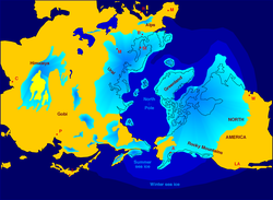
Northern Hemisphere glaciation during the Last Glacial Maximum. The creation of 3 to 4 km (1.9 to 2.5 mi) thick ice sheets equate to a global sea level drop of about 120 m (390 ft)

The Quaternary glaciation, also known as the Pleistocene glaciation, is an alternating series of glacial and interglacial periods during the Quaternary period that began 2.58 Ma (million years ago) and is ongoing. Although geologists describe the entire time period up to the present as an "ice age", in popular culture the term "ice age" is usually associated with just the most recent glacial period during the Pleistocene or the Pleistocene epoch in general. Since planet Earth still has ice sheets, geologists consider the Quaternary glaciation to be ongoing, with the Earth now experiencing an interglacial period.

During the Quaternary glaciation, ice sheets appeared. During glacial periods they expanded, and during interglacial periods they contracted. Since the end of the last glacial period, the only surviving ice sheets are the Antarctic and Greenland ice sheets. Other ice sheets, such as the Laurentide Ice Sheet, formed during glacial periods, had completely melted and disappeared during interglacials. The major effects of the Quaternary glaciation have been the erosion of land and the deposition of material, both over large parts of the continents; the modification of river systems; the creation of millions of lakes, including the development of pluvial lakes far from the ice margins; changes in sea level; the isostatic adjustment of the Earth's crust; flooding; and abnormal winds. The ice sheets themselves, by raising the albedo (the extent to which the radiant energy of the Sun is reflected from Earth) created significant feedback to further cool the climate. These effects have shaped entire environments on land and in the oceans, and in their associated biological communities.

Before the Quaternary glaciation, land-based ice appeared, and then disappeared, during at least four other ice ages.

Discovery

Evidence for the quaternary glaciation was first understood in the 18th and 19th centuries as part of the scientific revolution.

Over the last century, extensive field observations have provided evidence that continental glaciers covered large parts of Europe, North America, and Siberia. Maps of glacial features were compiled after many years of fieldwork by hundreds of geologists who mapped the location and orientation of drumlins, eskers, moraines, striations, and glacial stream channels in order to reveal the extent of the ice sheets, the direction of their flow, and the locations of systems of meltwater channels. They also allowed scientists to decipher a history of multiple advances and retreats of the ice. Even before the theory of worldwide glaciation was generally accepted, many observers recognized that more than a single advance and retreat of the ice had occurred.

Description

Graph of reconstructed temperature (blue), CO2 (green), and dust (red) from the Vostok Station ice core for the past 420,000 years

To geologists, an ice age is marked by the presence of large amounts of land-based ice. Prior to the Quaternary glaciation, land-based ice formed during at least four earlier geologic periods: the Karoo (360–260 Ma), Andean-Saharan (450–420 Ma), Cryogenian (720–635 Ma) and Huronian (2,400–2,100 Ma).

Within the Quaternary Period, or ice age, there were also periodic fluctuations of the total volume of land ice, the sea level, and global temperatures. During the colder episodes (referred to as glacial periods, or simply glacials) large ice sheets at least 4 km (2.5 mi) thick at their maximum existed in Europe, North America, and Siberia. The shorter and warmer intervals between glacials, when continental glaciers retreated, are referred to as interglacials. These are evidenced by buried soil profiles, peat beds, and lake and stream deposits separating the unsorted, unstratified deposits of glacial debris.

Initially the fluctuation period was about 41,000 years, but following the Mid-Pleistocene Transition it has slowed to about 100,000 years, as evidenced most clearly by ice cores for the past 800,000 years and marine sediment cores for the earlier period. Over the past 740,000 years there have been eight glacial cycles.

The entire Quaternary Period, starting 2.58 Ma, is referred to as an ice age because at least one permanent large ice sheet—the Antarctic ice sheet—has existed continuously. There is uncertainty over how much of Greenland was covered by ice during each interglacial.

Currently, Earth is in an interglacial period, which marked the beginning of the Holocene epoch. The current interglacial began between 15,000 and 10,000 years ago; this caused the ice sheets from the last glacial period to begin to disappear. Remnants of these last glaciers, now occupying about 10% of the world's land surface, still exist in Greenland, Antarctica and some mountainous regions.

During the glacial periods, the present (i.e. interglacial) hydrologic system was completely interrupted throughout large areas of the world and was considerably modified in others. Due to the volume of ice on land, sea level was about 120 metres (394 ft) lower than present.

Causes

Earth's history of glaciation is a product of the internal variability of Earth's climate system (e.g., ocean currents, carbon cycle), interacting with external forcing by phenomena outside the climate system (e.g., changes in earth's orbit, volcanism, and changes in solar output).

Astronomical cycles

The role of Earth's orbital changes in controlling climate was first advanced by James Croll in the late 19th century. Later, Milutin Milanković, a Serbian geophysicist, elaborated on the theory and calculated that these irregularities in Earth's orbit could cause the climatic cycles now known as Milankovitch cycles. They are the result of the additive behavior of several types of cyclical changes in Earth's orbital properties.

Relationship of Earth's orbit to periods of glaciation

Changes in the orbital eccentricity of Earth occur on a cycle of about 100,000 years. The inclination, or tilt, of Earth's axis varies periodically between 22° and 24.5° in a cycle 41,000 years long. The tilt of Earth's axis is responsible for the seasons; the greater the tilt, the greater the contrast between summer and winter temperatures. Precession of the equinoxes, or wobbles of Earth's rotation axis, have a periodicity of 26,000 years. According to the Milankovitch theory, these factors cause a periodic cooling of Earth, with the coldest part in the cycle occurring about every 40,000 years. The main effect of the Milankovitch cycles is to change the contrast between the seasons, not the overall amount of solar heat Earth receives. The result is less ice melting than accumulating, and glaciers build up.

Milankovitch worked out the ideas of climatic cycles in the 1920s and 1930s, but it was not until the 1970s that a sufficiently long and detailed chronology of the Quaternary temperature changes was worked out to test the theory adequately. Studies of deep-sea cores, and the fossils contained in them, indicate that the fluctuation of climate during the last few hundred thousand years is remarkably close to that predicted by Milankovitch.

A problem with the theory is that these astronomical cycles have been in existence for many millions of years, but glaciation is a rare occurrence. Astronomical cycles correlate with glacial and interglacial periods, and their transitions, within a long-term ice age but do not initiate these long-term ice ages.

Atmospheric composition

One theory holds that decreases in atmospheric CO
2
, an important greenhouse gas, started the long-term cooling trend that eventually led to glaciation. Geological evidence indicates a decrease of more than 90% in atmospheric CO
2
since the middle of the Mesozoic Era. An analysis of CO
2
reconstructions from alkenone records shows that CO
2
in the atmosphere declined before and during Antarctic glaciation, and supports a substantial CO
2
decrease as the primary cause of Antarctic glaciation.

CO
2
levels also play an important role in the transitions between interglacials and glacials. High CO
2
contents correspond to warm interglacial periods, and low CO
2
to glacial periods. However, studies indicate that CO
2
may not be the primary cause of the interglacial-glacial transitions, but instead acts as a feedback. The explanation for this observed CO
2
variation "remains a difficult attribution problem".

Plate tectonics and ocean currents

An important component in the development of long-term ice ages is the positions of the continents. These can control the circulation of the oceans and the atmosphere, affecting how ocean currents carry heat to high latitudes. Throughout most of geologic time, the North Pole appears to have been in a broad, open ocean that allowed major ocean currents to move unabated. Equatorial waters flowed into the polar regions, warming them. This produced mild, uniform climates that persisted throughout most of geologic time.

But during the Cenozoic Era, the large North American and South American continental plates drifted westward from the Eurasian plate. This interlocked with the development of the Atlantic Ocean, running north–south, with the North Pole in the small, nearly landlocked basin of the Arctic Ocean. The Drake passage opened 33.9 million years ago (the Eocene-Oligocene transition), severing Antarctica from South America. The Antarctic Circumpolar Current could then flow through it, isolating Antarctica from warm waters and triggering the formation of its huge ice sheets. The Isthmus of Panama developed at a convergent plate margin about 2.6 million years ago, and further separated oceanic circulation, closing the last strait, outside the polar regions, that had connected the Pacific and Atlantic Oceans. This increased poleward salt and heat transport, strengthening the North Atlantic thermohaline circulation, which supplied enough moisture to arctic latitudes to create the northern glaciation.

Rise of mountains

The elevation of continents surface, often in the form of mountain formation, is thought to have contributed to cause the Quaternary glaciation. Modern glaciers correlate often to mountainous areas. The gradual movement of the bulk of Earth's landmasses away from the Tropics in conjection with increased mountain formation in the Late Cenozoic meant more surfaces at high altitude and latitudes favouring the formation of glaciers. For example, the Greenland Ice Sheet formed in connection to the uplift of the West Greenland and East Greenland uplands. The Western and Eastern Greenland mountains constitute passive continental margins that were uplifted in two phases, 10 and 5 million years ago, in the Miocene epoch. Computer modelling shows that the uplift would have enabled glaciation by producing increased orographic precipitation and cooling the surface temperatures. For the Andes it is known that the Principal Cordillera had risen to heights that allowed for the development of valley glaciers about 1 million years ago.

Effects

The presence of so much ice upon the continents had a profound effect upon almost every aspect of Earth's hydrologic system. The most obvious effects are the spectacular mountain scenery and other continental landscapes fashioned both by glacial erosion and deposition instead of running water. Entirely new landscapes covering millions of square kilometers were formed in a relatively short period of geologic time. In addition, the vast bodies of glacial ice affected Earth well beyond the glacier margins. Directly or indirectly, the effects of glaciation were felt in every part of the world.

Lakes

The Quaternary glaciation created more lakes than all other geologic processes combined. The reason is that a continental glacier completely disrupts the preglacial drainage system. The surface over which the glacier moved was scoured and eroded by the ice, leaving many closed, undrained depressions in the bedrock. These depressions filled with water and became lakes.

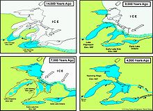
A diagram of the formation of the Great Lakes

Very large lakes were created along the glacial margins. The ice on both North America and Europe was about 3,000 m (10,000 ft) thick near the centers of maximum accumulation, but it tapered toward the glacier margins. Ice weight caused crustal subsidence, which was greatest beneath the thickest accumulation of ice. As the ice melted, rebound of the crust lagged behind, producing a regional slope toward the ice. This slope formed basins that have lasted for thousands of years. These basins became lakes or were invaded by the ocean. The Baltic Sea and the Great Lakes of North America were formed primarily in this way.

The numerous lakes of the Canadian Shield, Sweden, and Finland are thought to have originated at least partly from glaciers' selective erosion of weathered bedrock.

Pluvial lakes

The climatic conditions that cause glaciation had an indirect effect on arid and semiarid regions far removed from the large ice sheets. The increased precipitation that fed the glaciers also increased the runoff of major rivers and intermittent streams, resulting in the growth and development of large pluvial lakes. Most pluvial lakes developed in relatively arid regions where there typically was insufficient rain to establish a drainage system leading to the sea. Instead, stream runoff flowed into closed basins and formed playa lakes. With increased rainfall, the playa lakes enlarged and overflowed. Pluvial lakes were most extensive during glacial periods. During interglacial stages, with less rain, the pluvial lakes shrank to form small salt flats.

Isostatic adjustment

Major isostatic adjustments of the lithosphere during the Quaternary glaciation were caused by the weight of the ice, which depressed the continents. In Canada, a large area around Hudson Bay was depressed below (modern) sea level, as was the area in Europe around the Baltic Sea. The land has been rebounding from these depressions since the ice melted. Some of these isostatic movements triggered large earthquakes in Scandinavia about 9,000 years ago. These earthquakes are unique in that they are not associated with plate tectonics.

Studies have shown that the uplift has taken place in two distinct stages. The initial uplift following deglaciation was rapid (called "elastic"), and took place as the ice was being unloaded. After this "elastic" phase, uplift proceed by "slow viscous flow" so the rate decreased exponentially after that. Today, typical uplift rates are of the order of 1 cm per year or less. In northern Europe, this is clearly shown by the GPS data obtained by the BIFROST GPS network. Studies suggest that rebound will continue for about at least another 10,000 years. The total uplift from the end of deglaciation depends on the local ice load and could be several hundred meters near the center of rebound.

Winds

The presence of ice over so much of the continents greatly modified patterns of atmospheric circulation. Winds near the glacial margins were strong and persistent because of the abundance of dense, cold air coming off the glacier fields. These winds picked up and transported large quantities of loose, fine-grained sediment brought down by the glaciers. This dust accumulated as loess (wind-blown silt), forming irregular blankets over much of the Missouri River valley, central Europe, and northern China.

Sand dunes were much more widespread and active in many areas during the early Quaternary period. A good example is the Sand Hills region in Nebraska, USA, which covers an area of about 60,000 km2 (23,166 sq mi). This region was a large, active dune field during the Pleistocene epoch, but today is largely stabilized by grass cover.

Ocean currents

Thick glaciers were heavy enough to reach the sea bottom in several important areas, thus blocking the passage of ocean water and thereby affecting ocean currents. In addition to direct effects, this caused feedback effects as ocean currents contribute to global heat transfer.

Gold deposits

Moraines and till deposited by Quaternary glaciers have contributed to the formation of valuable placer deposits of gold. This is the case of southernmost Chile where reworking of Quaternary moraines have concentrated gold offshore.

Records of prior glaciation

500 million years of climate change.

Glaciation has been a rare event in Earth's history, but there is evidence of widespread glaciation during the late Paleozoic Era (300 to 200 Ma) and the late Precambrian (i.e. the Neoproterozoic Era, 800 to 600 Ma). Before the current ice age, which began 2 to 3 Ma, Earth's climate was typically mild and uniform for long periods of time. This climatic history is implied by the types of fossil plants and animals and by the characteristics of sediments preserved in the stratigraphic record. There are, however, widespread glacial deposits, recording several major periods of ancient glaciation in various parts of the geologic record. Such evidence suggests major periods of glaciation prior to the current Quaternary glaciation.

One of the best documented records of pre-Quaternary glaciation, called the Karoo Ice Age, is found in the late Paleozoic rocks in South Africa, India, South America, Antarctica, and Australia. Exposures of ancient glacial deposits are numerous in these areas. Deposits of even older glacial sediment exist on every continent except South America. These indicate that two other periods of widespread glaciation occurred during the late Precambrian, producing the Snowball Earth during the Cryogenian Period.

Next glacial period

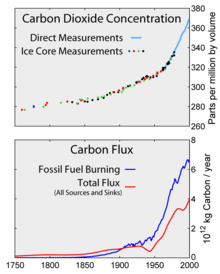
Increase in atmospheric CO
2
since the Industrial Revolution.

The warming trend following the Last Glacial Maximum, since about 20,000 years ago, has resulted in a sea level rise by about 130 metres (427 ft). This warming trend subsided about 6,000 years ago, and sea level has been comparatively stable since the Neolithic. The present interglacial period (the Holocene climatic optimum) has been fairly stable and warm, but the previous one was interrupted by numerous cold spells lasting hundreds of years. If the previous period was more typical than the present one, the period of stable climate, which allowed the Neolithic Revolution and by extension human civilization, may have been possible only because of a highly unusual period of stable temperature.

Based on orbital models, the cooling trend initiated about 6,000 years ago will continue for another 23,000 years. Slight changes in the Earth's orbital parameters may, however, indicate that, even without any human contribution, there will not be another glacial period for the next 50,000 years. It is possible that the current cooling trend may be interrupted by an interstadial phase (a warmer period) in about 60,000 years, with the next glacial maximum reached only in about 100,000 years.

Based on past estimates for interglacial durations of about 10,000 years, in the 1970s there was some concern that the next glacial period would be imminent. However, slight changes in the eccentricity of Earth's orbit around the Sun suggest a lengthy interglacial period lasting about another 50,000 years. Additionally, human impact is now seen as possibly extending what would already be an unusually long warm period. Projection of the timeline for the next glacial maximum depend crucially on the amount of CO
2
in the atmosphere
. Models assuming increased CO
2
levels at 750 parts per million (ppm; current levels are at 407 ppm) have estimated the persistence of the current interglacial period for another 50,000 years. However, more recent studies concluded that the amount of heat trapping gases emitted into Earth's oceans and atmosphere will prevent the next glacial (ice age), which otherwise would begin in around 50,000 years, and likely more glacial cycles.

Holocene climatic optimum

From Wikipedia, the free encyclopedia

The Holocene Climate Optimum (HCO) was a warm period that occurred in roughly the interval roughly 9,000 to 5,000 years BP, with a thermal maximum around 8000 years BP. It has also been known by many other names as well, such as Altithermal, Climatic Optimum, Holocene Megathermal, Holocene Optimum, Holocene Thermal Maximum, Hypsithermal, and Mid-Holocene Warm Period.

The warm period was followed by a gradual decline until about two millennia ago.

Global effects

Temperature variations during the Holocene from a collection of different reconstructions and their average. The most recent period is on the right, but the recent warming is seen only in the inset.

The Holocene Climate Optimum warm event consisted of increases of up to 4 °C near the North Pole (in one study, winter warming of 3 to 9 °C and summer of 2 to 6 °C in northern central Siberia). Northwestern Europe experienced warming, but there was cooling in Southern Europe.[2] The average temperature change appears to have declined rapidly with latitude and so essentially no change in mean temperature is reported at low and middle latitudes. Tropical reefs tend to show temperature increases of less than 1 °C. The tropical ocean surface at the Great Barrier Reef about 5350 years ago was 1 °C warmer and enriched in 18O by 0.5 per mil relative to modern seawater. In terms of the global average, temperatures were probably warmer than now, depending on estimates of latitude dependence and seasonality in response patterns. Temperatures in the Northern Hemisphere were warmer than average during the summers, but the tropics and parts of the Southern Hemisphere were colder than average.

Of 140 sites across the western Arctic, there is clear evidence for conditions that were warmer than now at 120 sites. At 16 sites for which quantitative estimates have been obtained, local temperatures were on average 1.6±0.8 °C higher during the optimum than now. Northwestern North America reached peak warmth first, from 11,000 to 9,000 years ago, but the Laurentide Ice Sheet still chilled eastern Canada. Northeastern North America experienced peak warming 4,000 years later. Along the Arctic Coastal Plain in Alaska, there are indications of summer temperatures 2–3 °C warmer than now. Research indicates that the Arctic had less sea ice than now.

Current desert regions of Central Asia were extensively forested because of higher rainfall, and the warm temperate forest belts in China and Japan were extended northwards.

West African sediments additionally record the African humid period, an interval between 16,000 and 6,000 years ago during which Africa was much wetter than now. That was caused by a strengthening of the African monsoon by changes in summer radiation, which resulted from long-term variations in the Earth's orbit around the Sun. The "Green Sahara" was dotted with numerous lakes, containing typical African lake crocodile and hippopotamus fauna. A curious discovery from the marine sediments is that the transitions into and out of the wet period occurred within decades, not the previously-thought extended periods. It is hypothesized that humans played a role in altering the vegetation structure of North Africa at some point after 8,000 years ago by introducing domesticated animals, which contributed to the rapid transition to the arid conditions that are now found in many locations in the Sahara.

In the far Southern Hemisphere (New Zealand and Antarctica), the warmest period during the Holocene appears to have been roughly 10,500 to 8,000 years ago, immediately after the end of the last ice age. By 6,000 years ago, which is normally associated with the Holocene Climatic Optimum in the Northern Hemisphere, those regions had reached temperatures similar to today, and they did not participate in the temperature changes of the north. However, some authors have used the term "Holocene Climatic Optimum" to describe the earlier southern warm period as well.

Comparison of ice cores

A comparison of the delta profiles at Byrd Station, West Antarctica (2164 m ice core recovered, 1968), and Camp Century, Northwest Greenland, shows the post-glacial climatic optimum. Points of correlation indicate that in both locations, the Holocene climatic optimum (post-glacial climatic optimum) probably occurred at the same time. A similar comparison is evident between the Dye 3 1979 and the Camp Century 1963 cores regarding this period.

The Hans Tausen Ice Cap, in Peary Land (northern Greenland), was drilled in 1977, with a new deep drill to 325 m. The ice core contained distinct melt layers all the way to the bedrock. That indicates that Hans Tausen Iskappe contains no ice from the last glaciation and so the world's northernmost ice cap melted away during the post-glacial climatic optimum and was rebuilt when the climate cooled some 4000 years ago.

From the delta-profile, the Renland ice cap in the Scoresby Sound has always been separated from the inland ice, but all of the delta-leaps revealed in the Camp Century 1963 core recurred in the Renland 1985 ice core. The Renland ice core from East Greenland apparently covers a full glacial cycle from the Holocene into the previous Eemian interglacial. The Renland ice core is 325 m long.

Although the depths are different, the GRIP and NGRIP cores also contain the climatic optimum at very similar times.

Milankovitch cycles

Milankovitch cycles.

The climatic event was probably a result of predictable changes in the Earth's orbit (Milankovitch cycles) and a continuation of changes that caused the end of the last glacial period.

The effect would have had the maximum heating of the Northern Hemisphere 9,000 years ago, when the axial tilt was 24° and the nearest approach to the Sun (perihelion) was during the Northern Hemisphere's summer. The calculated Milankovitch Forcing would have provided 0.2% more solar radiation (+40 W/m2) to the Northern Hemisphere in summer, which tended to cause more heating. There seems to have been the predicted southward shift in the global band of thunderstorms, the Intertropical Convergence Zone.

However, orbital forcing would predict maximum climate response several thousand years earlier than those observed in the Northern Hemisphere. The delay may be a result of the continuing changes in climate, as the Earth emerged from the last glacial period and related to ice–albedo feedback. Different sites often show climate changes at somewhat different times and lasting for different durations. At some locations, climate changes may have begun as early as 11,000 years ago or have persisted until 4,000 years ago. As noted above, the warmest interval in the far south significantly preceded warming in the north.

Other changes

Significant temperature changes do not appear to have occurred at most low-latitude sites, but other climate changes have been reported, such as significantly wetter conditions in Africa, Australia and Japan and desert-like conditions in the Midwestern United States. Areas around the Amazon show temperature increases and drier conditions.

Abrupt climate change

From Wikipedia, the free encyclopedia
 
Clathrate hydrates have been identified as a possible agent for abrupt changes.

An abrupt climate change occurs when the climate system is forced to transition at a rate that is determined by the climate system energy-balance, and which is more rapid than the rate of change of the external forcing, though it may include sudden forcing events such as meteorite impacts. Abrupt climate change therefore is a variation beyond the variability of a climate. Past events include the end of the Carboniferous Rainforest Collapse, Younger Dryas, Dansgaard-Oeschger events, Heinrich events and possibly also the Paleocene–Eocene Thermal Maximum. The term is also used within the context of global warming to describe sudden climate change that is detectable over the time-scale of a human lifetime, possibly as the result of feedback loops within the climate system or tipping points.

Timescales of events described as 'abrupt' may vary dramatically. Changes recorded in the climate of Greenland at the end of the Younger Dryas, as measured by ice-cores, imply a sudden warming of +10 °C (+18 °F) within a timescale of a few years. Other abrupt changes are the +4 °C (+7.2 °F) on Greenland 11,270 years ago or the abrupt +6 °C (11 °F) warming 22,000 years ago on Antarctica. By contrast, the Paleocene-Eocene thermal maximum may have initiated anywhere between a few decades and several thousand years. Finally, Earth System's models project that under ongoing greenhouse gas emissions as early as 2047, the Earth's near surface temperature could depart from the range of variability in the last 150 years, affecting over 3 billion people and most places of great species diversity on Earth.

Definitions

According to the Committee on Abrupt Climate Change of the National Research Council:

There are essentially two definitions of abrupt climate change:

  • In terms of physics, it is a transition of the climate system into a different mode on a time scale that is faster than the responsible forcing.
  • In terms of impacts, "an abrupt change is one that takes place so rapidly and unexpectedly that human or natural systems have difficulty adapting to it".

These definitions are complementary: the former gives some insight into how abrupt climate change comes about; the latter explains why there is so much research devoted to it.

General

Possible tipping elements in the climate system include regional effects of global warming, some of which had abrupt onset and may therefore be regarded as abrupt climate change. Scientists have stated, "Our synthesis of present knowledge suggests that a variety of tipping elements could reach their critical point within this century under anthropogenic climate change".

It has been postulated that teleconnections, oceanic and atmospheric processes, on different timescales, connect both hemispheres during abrupt climate change.

The IPCC states that global warming "could lead to some effects that are abrupt or irreversible".

A 2013 report from the U.S. National Research Council called for attention to the abrupt impacts of climate change, stating that even steady, gradual change in the physical climate system can have abrupt impacts elsewhere, such as in human infrastructure and ecosystems if critical thresholds are crossed. The report emphasizes the need for an early warning system that could help society better anticipate sudden changes and emerging impacts.

Scientific understanding of abrupt climate change is generally poor. The probability of abrupt change for some climate related feedbacks may be low. Factors that may increase the probability of abrupt climate change include higher magnitudes of global warming, warming that occurs more rapidly and warming that is sustained over longer time periods.

Climate models

Climate models are currently unable to predict abrupt climate change events, or most of the past abrupt climate shifts. A potential abrupt feedback due to thermokarst lake formations in the Arctic, in response to thawing permafrost soils, releasing additional greenhouse gas methane, is currently not accounted for in climate models.

Possible precursor

Most abrupt climate shifts are likely due to sudden circulation shifts, analogous to a flood cutting a new river channel. The best-known examples are the several dozen shutdowns of the North Atlantic Ocean's Meridional Overturning Circulation during the last ice age, affecting climate worldwide.

  • The current warming of the Arctic, the duration of the summer season, is considered abrupt and massive.
  • Antarctic ozone depletion caused significant atmospheric circulation changes.
  • There have also been two occasions when the Atlantic's Meridional Overturning Circulation lost a crucial safety factor. The Greenland Sea flushing at 75 °N shut down in 1978, recovering over the next decade. Then the second-largest flushing site, the Labrador Sea, shut down in 1997 for ten years. While shutdowns overlapping in time have not been seen during the 50 years of observation, previous total shutdowns had severe worldwide climate consequences.

Effects

A summary of the path of the thermohaline circulation. Blue paths represent deep-water currents, and red paths represent surface currents.
 
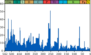
The Permian–Triassic extinction event, labelled "P-Tr" here, is the most significant extinction event in this plot for marine genera.

Abrupt climate change has likely been the cause of wide-ranging and severe effects:

Climate feedback effects

The dark ocean surface reflects only 6 percent of incoming solar radiation; sea ice reflects 50 to 70 percent.
 

One source of abrupt climate change effects is a feedback process, in which a warming event causes a change that adds to further warming. The same can apply to cooling. Examples of such feedback processes are:

Volcanism

Isostatic rebound in response to glacier retreat (unloading) and increased local salinity have been attributed to increased volcanic activity at the onset of the abrupt Bølling-Allerød warming. They are associated with the interval of intense volcanic activity, hinting at an interaction between climate and volcanism: enhanced short-term melting of glaciers, possibly via albedo changes from particle fallout on glacier surfaces.

Past events

The Younger Dryas period of abrupt climate change is named after the Alpine flower, Dryas.

Several periods of abrupt climate change have been identified in the paleoclimatic record. Notable examples include:

  • About 25 climate shifts, called Dansgaard-Oeschger cycles, which have been identified in the ice core record during the glacial period over the past 100,000 years.
  • The Younger Dryas event, notably its sudden end. It is the most recent of the Dansgaard-Oeschger cycles and began 12,900 years ago and moved back into a warm-and-wet climate regime about 11,600 years ago. It has been suggested that "the extreme rapidity of these changes in a variable that directly represents regional climate implies that the events at the end of the last glaciation may have been responses to some kind of threshold or trigger in the North Atlantic climate system." A model for this event based on disruption to the thermohaline circulation has been supported by other studies.
  • The Paleocene-Eocene Thermal Maximum, timed at 55 million years ago, which may have been caused by the release of methane clathrates, although potential alternative mechanisms have been identified. This was associated with rapid ocean acidification
  • The Permian–Triassic Extinction Event, in which up to 95% of all species became extinct, has been hypothesized to be related to a rapid change in global climate. Life on land took 30 million years to recover.
  • The Carboniferous Rainforest Collapse occurred 300 million years ago, at which time tropical rainforests were devastated by climate change. The cooler, drier climate had a severe effect on the biodiversity of amphibians, the primary form of vertebrate life on land.

There are also abrupt climate changes associated with the catastrophic draining of glacial lakes. One example of this is the 8.2-kiloyear event, which is associated with the draining of Glacial Lake Agassiz. Another example is the Antarctic Cold Reversal, c. 14,500 years before present (BP), which is believed to have been caused by a meltwater pulse probably from either the Antarctic ice sheet or the Laurentide Ice Sheet. These rapid meltwater release events have been hypothesized as a cause for Dansgaard-Oeschger cycles,

A 2017 study concluded that similar conditions to today's Antarctic ozone hole (atmospheric circulation and hydroclimate changes), ∼17,700 years ago, when stratospheric ozone depletion contributed to abrupt accelerated Southern Hemisphere deglaciation. The event coincidentally happened with an estimated 192-year series of massive volcanic eruptions, attributed to Mount Takahe in West Antarctica.

Entropy (information theory)

From Wikipedia, the free encyclopedia https://en.wikipedia.org/wiki/Entropy_(information_theory) In info...