Search This Blog

Saturday, September 30, 2023

Effects of climate change on small island countries

From Wikipedia, the free encyclopedia
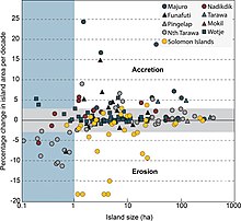
Surface area change of islands in the Central Pacific and Solomon Islands

The effect of climate change on small island countries can be extreme because of low-lying coasts, relatively small land masses, and exposure to extreme weather. The effects of climate change, particularly sea level rise and increasingly intense tropical cyclones, threaten the existence of many island countries, island peoples and their cultures, and will alter their ecosystems and natural environments. Several Small Island Developing States (SIDS) are among the most vulnerable nations to climate change.

Some small and low population islands are without adequate resources to protect their islands, inhabitants, and natural resources. In addition to the risks to human health, livelihoods, and inhabitable space, the pressure to leave islands is often barred by the inability to access the resources needed to relocate. The nations of the Caribbean, Pacific Islands and Maldives are already experiencing considerable impacts of climate change, making efforts to implement climate change adaptation a critical issue for them.

Efforts to combat these environmental changes are ongoing and multinational. Due to their vulnerability and limited contribution to greenhouse gas emissions, some island countries have made advocacy for global cooperation on climate change mitigation a key aspect of their foreign policy. Governments face a complex task when combining gray infrastructure with green infrastructure and nature-based solutions to help with disaster risk management in areas such as flood control, early warning systems, nature-based solutions, and integrated water resource management. As of March 2022, the Asian Development Bank has committed $3.62 billion to help small island developing states with climate change, transport, energy, and health projects.

Greenhouse gas emissions

Small Island Developing States make minimal contribution to global greenhouse gas emissions, with a combined total of less than 1%. However, that does not indicate that greenhouse emissions are not produced at all, and it is recorded that the annual total greenhouse gas emissions from islands could range from 292.1 to 29,096.2 [metric] tonne CO2-equivalent.

Impacts on the natural environment

Expected impacts on small islands include:

  • extreme weather events
  • changes in sea level
  • increased sensitivity and exposure to the effects of climate change.
  • deterioration in coastal conditions, such as beach erosion and coral bleaching, which will likely affect local resources such as fisheries, as well as the value of tourism destinations.
  • increased inundation, storm surge, erosion, and other coastal hazards caused by sea-level rise, threatening vital infrastructure, settlements, and facilities that support the livelihood of island communities.
  • reduction of already limited water resources to the point that they become insufficient to meet demand during low-rainfall periods by mid-century, especially on small islands (such as in the Caribbean and the Pacific Ocean)
  • invasion by non-native species increasing with higher temperatures, particularly in mid- and high-latitude islands.

There are many secondary effects of climate change and sea-level rise particular to island nations. According to the US Fish and Wildlife Service, climate change in the Pacific Islands will cause "continued increases in air and ocean surface temperatures in the Pacific, increased frequency of extreme weather events, and increased rainfall during the summer months and a decrease in rainfall during the winter months". This would entail distinct changes to the small, diverse, and isolated island ecosystems and biospheres present within many of these island nations.

Sea level rise

One of the dominant manifestations of climate change is sea level rise. NOAA estimates that "since 1992, new methods of satellite altimetry (the measurement of elevation or altitude) indicate a rate of rise of 0.12 inches per year". Similarly NASA calculates that the average sea level rise is 3.41 mm per year and that sea-level rise is directly caused by the expansion of water as it warms and the melting of polar ice caps. Both of these changes are dependent on global warming as a result of climate change. Sea level rise is especially threatening to low-lying island nations because seas are encroaching upon limited habitable land and threatening existing cultures. Stefan Rahmstorf, a professor of Ocean Physics at Potsdam University in Germany notes "even limiting warming to 2 degrees, in my view, will still commit some island nations and coastal cities to drown."

Research published in 2015 contradicts the claim that rising sea levels will necessarily submerge island nations. Studies by Paul Kench, a geomorphologist at the University of Auckland, have shown that "reef islands change shape and move around in response to shifting sediments, and that many of them are growing in size, not shrinking, as sea level inches upward". At the same time Kench says that "for the areas that have been transformed by human development, such as the capitals of Kiribati, Tuvalu, and the Maldives, the future is considerably gloomier" because these islands cannot adapt to rising sea levels and are therefore greatly threatened.

Impacts on people

September 2019 climate strikes in Dili, East Timor.

The Intergovernmental Panel on Climate Change warned in 2001 that small island countries will experience considerable economic and social consequences due to climate change.

A study that engaged the experiences of residents in atoll communities found that the cultural identities of these populations are strongly tied to these lands. Human rights activists argue that the potential loss of entire atoll countries, and consequently the loss of national sovereignty, self-determination, cultures, and indigenous lifestyles cannot be compensated for financially. Some researchers suggest that the focus of international dialogues on these issues should shift from ways to relocate entire communities to strategies that instead allow for these communities to remain on their lands.

Agriculture and fisheries

Climate change poses a risk to food security in many Pacific Islands, impacting fisheries and agriculture. As sea level rises, island nations are at increased risk of losing coastal arable land to degradation as well as salination. Once the limited available soil on these islands becomes salinated, it becomes very difficult to produce subsistence crops such as breadfruit. This would severely impact the agricultural and commercial sector in nations such as the Marshall Islands and Kiribati.

In addition, local fisheries would also be affected by higher ocean temperatures and increased ocean acidification. As ocean temperatures rise and the pH of oceans decreases, many fish and other marine species would die out or change their habits and range. As well as this, water supplies and local ecosystems such as mangroves, are threatened by global warming.

Economic impacts

SIDS may also have reduced financial and human capital to mitigate climate change risk, as many rely on international aid to cope with disasters like severe storms. Worldwide, climate change is projected to have an average annual loss of 0.5% GDP by 2030; in Pacific SIDS, it will be 0.75–6.5% GDP by 2030. Caribbean SIDS will have average annual losses of 5% by 2025, escalating to 20% by 2100 in projections without regional mitigation strategies. The tourism sector of many island countries is particularly threatened by increased occurrences of extreme weather events such as hurricanes and droughts.

Public health

Climate change impacts small island ecosystems in ways that have a detrimental effect on public health. In island nations, changes in sea levels, temperature, and humidity may increase the prevalence of mosquitoes and diseases carried by them such as malaria and Zika virus. Rising sea levels and severe weather such as flooding and droughts may render agricultural land unusable and contaminate freshwater drinking supplies. Flooding and rising sea levels also directly threaten populations, and in some cases may be a threat to the entire existence of the island.

Mitigation and adaptation

Relocation and migration

Climate migration has been discussed in popular media as a potential adaptation approach for the populations of islands threatened by sea level rise. A 2015 review in Climatic Change found that these depictions are often sensationalist or problematic, although migration may likely form a part of adaptation. Mobility has long been a part of life in islands, but could be used in combination with local adaptation measures.

Climate resilient economies

Many SIDS now understand the need to move towards low-carbon, climate resilient economies, as set out in the Caribbean Community (CARICOM) implementation plan for climate change-resilient development. SIDS often rely heavily on imported fossil fuels, spending an ever-larger proportion of their GDP on energy imports. Renewable technologies have the advantage of providing energy at a lower cost than fossil fuels and making SIDS more sustainable. Barbados has been successful in adopting the use of solar water heaters (SWHs). A 2012 report published by the Climate & Development Knowledge Network showed that its SWH industry now boasts over 50,000 installations. These have saved consumers as much as US$137 million since the early 1970s. The report suggested that Barbados' experience could be easily replicated in other SIDS with high fossil fuel imports and abundant sunshine.

International cooperation

International meeting of Small Island Developing States in 2014.
Maldives President Mohamed Nasheed speaks at the launch of the Climate Vulnerability Monitor in 2010.

The governments of several island nations have made political advocacy for greater international ambition on climate change mitigation and climate change adaptation a component of their foreign policy and international alliances. The Alliance of Small Island States (ASIS) have had some sway in the United Nations Framework Convention on Climate Change. The 43 members of the alliance have held the position of limiting global warming to 1.5°C, and advocated for this at the 2015 United Nations Climate Change Conference, influencing the goals of the Paris Agreement. Marshall Islands Prime Minister Tony deBrum was central in forming the High Ambition Coalition at the conference. Meetings of the Pacific Islands Forum have also discussed the issue.

The Maldives and Tuvalu particularly have played a prominent role on the international stage. In 2002, Tuvalu threatened to sue the United States and Australia in the International Court of Justice for their contribution to climate change and for not ratifying the Kyoto Protocol. The governments of both of these countries have cooperated with environmental advocacy networks, non-governmental organisations and the media to draw attention to the threat of climate change to their countries. At the 2009 United Nations Climate Change Conference, Tuvalu delegate Ian Fry spearheaded an effort to halt negotiations and demand a comprehensive, legally binding agreement.

By country and region

Caribbean

Graph showing historic temperature change globally and in the Caribbean region.
Climate change in the Caribbean poses major risks to the islands in the Caribbean. The main environmental changes expected to affect the Caribbean are a rise in sea level, stronger hurricanes, longer dry seasons and shorter wet seasons. As a result, climate change is expected to lead to changes in the economy, environment and population of the Caribbean. Temperature rise of 2 °C above preindustrial levels can increase the likelihood of extreme hurricane rainfall by four to five times in the Bahamas and three times in Cuba and Dominican Republic. Rise in sea level could impact coastal communities of the Caribbean if they are less than 3 metres (10 ft) above the sea. In Latin America and the Caribbean, it is expected that 29–32 million people may be affected by the sea level rise because they live below this threshold. The Bahamas is expected to be the most affected because at least 80% of the total land is below 10 meters elevation.

East Timor

East Timor's agriculture and food security is threatened by climate change. Sea level rise also threatens its coastal areas, including capital city Dili.

Maldives

The Maldives government have adapted infrastructure in capital city Malé to the threats of climate change, including beginning to build a wall around the city.
Climate change in the Maldives is a major issue for the country. As an archipelago of low-lying islands and atolls, many parts of the Maldives are threatened by sea level rise, with some predictions suggesting most of the nation will become uninhabitable during the 21st century. The country is striving to adapt to climate change, and Maldivian authorities have been prominent in international political advocacy to implement climate change mitigation.

Pacific islands

Fiji

Temperature change in Fiji, 1901 to 2020.

Climate change in Fiji is an exceptionally pressing issue for the country - as an island nation, Fiji is particularly vulnerable to rising sea levels, coastal erosion and extreme weather. These changes, along with temperature rise, will displace Fijian communities and will prove disruptive to the national economy - tourism, agriculture and fisheries, the largest contributors to the nation's GDP, will be severely impacted by climate change causing increases in poverty and food insecurity. As a party to both the Kyoto Protocol and the Paris Climate Agreement, Fiji hopes to achieve net-zero emissions by 2050 which, along with national policies, will help to mitigate the impacts of climate change.

The Human Rights Measurement Initiative finds that the climate crisis has worsened human rights conditions moderately (4.6 out of 6) in Fiji.

Kiribati

A sign on South Tarawa, Kiribati discussing the threat of sea level rise to the island, with its highest point being 3 metres above sea level.

The existence of the nation of Kiribati is imperilled by rising sea levels, with the country losing land every year. Many of its islands are currently or becoming inhabitable due to their shrinking size. Thus, the majority of the country's population resides in only a handful of islands, with more than half of its residents living on one island alone, Tarawa. This leads to other issues such as severe overcrowding in such a small area. In 1999, the uninhabited islands of Tebua Tarawa and Abanuea both disappeared underwater. The government's Kiribati Adaptation Program was launched in 2003 to mitigate the country's vulnerability to the issue. In 2008, fresh water supplies began being encroached by seawater, prompting President Anote Tong to request international assistance to begin relocating the country's population elsewhere.

Marshall Islands

Image of Majuro, Marshall Islands
Climate change in the Marshall Islands is a major issue for the country. As with many countries made up of low-lying islands, the Marshall Islands is highly vulnerable to sea level rise and other impacts of climate change. The atoll and capital city of Majuro are particularly vulnerable, and the issue poses significant implications for the country's population. These threats have prompted Marshallese political leaders to make climate change a key diplomatic issue, who have responded with initiatives such as the Majuro Declaration. The Human Rights Measurement Initiative finds that the climate crisis has worsened human rights conditions in the Marshall Islands greatly (5.0 out of 6). Human rights experts reported that the climate crisis has negatively impacted the economy, increased rates of unemployment, and lead to relocations to higher areas or migrations to other countries. 

Palau

The Palau government are concerned about the effects of climate change on the island nation. In 2008 Palau requested that the UN Security Council consider protection against rising sea levels due to climate change.

Tommy Remengesau, the president of Palau, has said:

Palau has lost at least one third of its coral reefs due to climate change related weather patterns. We also lost most of our agricultural production due to drought and extreme high tides. These are not theoretical, scientific losses -- they are the losses of our resources and our livelihoods.... For island states, time is not running out. It has run out. And our path may very well be the window to your own future and the future of our planet.

Solomon Islands

Between 1947 and 2014, six islands of the Solomon Islands disappeared due to sea level rise, while another six shrunk by between 20 and 62 per cent. Nuatambu Island was the most populated of these with 25 families living on it; 11 houses washed into the sea by 2011.

The Human Rights Measurement Initiative finds that the climate crisis has worsened human rights conditions in the Solomon Islands greatly (5.0 out of 6).  Human rights experts provided that the climate crisis has contributed to conflict in communities, negative future socio-economic outlook, and food instability. 

Tuvalu

Temperature change in Tuvalu, 1901 to 2020.
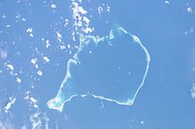
Satellite Image of Funafuti Atoll, Tuvalu

Tuvalu is a small Polynesian island nation located in the Pacific Ocean. It can be found about halfway between Hawaii and Australia. It is made up of nine tiny islands, five of which are coral atolls while the other four consists of land rising from the sea bed. All are low-lying islands with no point on Tuvalu being higher than 4.5m above sea level. Beside Funafuti, the capital of Tuvalu, sea-level rise is estimated at 1.2 ± 0.8 mm/year. As well as this, the dangerous peak high tides in Tuvalu are becoming higher causing greater danger. In response to sea level rise, Tuvalu is considering resettlement plans in addition to pushing for increased action in confronting climate change at the UN.

São Tomé and Príncipe

Annual temperature anomaly in São Tomé and Príncipe, 1901 to 2020.
Between 1950 and 2010, São Tomé and Príncipe experienced an increase of 1.5 °C in average annual temperature due to climate change. The country is considered highly vulnerable to its impacts. Climate change is projected to lead to an increased number of warm days and nights, hotter temperatures and increased precipitation. Sea level rise and saltwater intrusion will be major issues for the islands and climate change will have major impacts on agriculture in the country. The government began developing a National Adaptation Plan in 2022 to implement climate adaptation efforts, with support from the United Nations Environment Programme.

Seychelles

In the Seychelles, the impacts of climate change were observable in precipitation, air temperature and sea surface temperature by the early 2000s. Climate change poses a threat to its coral reef ecosystems, with drought conditions in 1999 and a mass bleaching event in 1998. Water management will be critically impacted.

Singapore

Singapore recognises that climate change in the decades ahead will have major implications for the island-nation. It has taken a three-prong approach to the issue - researching how the nation will be affected in specific details, implementing mitigation measures and adapting to the coming changes. For the research, a Centre for Climate Research Singapore (CCRS) has been established.

Wind shear

From Wikipedia, the free encyclopedia
Cirrus uncinus ice crystal plumes showing high-level wind shear, with changes in wind speed and direction

Wind shear (or windshear), sometimes referred to as wind gradient, is a difference in wind speed and/or direction over a relatively short distance in the atmosphere. Atmospheric wind shear is normally described as either vertical or horizontal wind shear. Vertical wind shear is a change in wind speed or direction with a change in altitude. Horizontal wind shear is a change in wind speed with a change in lateral position for a given altitude.

Wind shear is a microscale meteorological phenomenon occurring over a very small distance, but it can be associated with mesoscale or synoptic scale weather features such as squall lines and cold fronts. It is commonly observed near microbursts and downbursts caused by thunderstorms, fronts, areas of locally higher low-level winds referred to as low-level jets, near mountains, radiation inversions that occur due to clear skies and calm winds, buildings, wind turbines, and sailboats. Wind shear has significant effects on the control of an aircraft, and it has been the sole or a contributing cause of many aircraft accidents.

Sound movement through the atmosphere is affected by wind shear, which can bend the wave front, causing sounds to be heard where they normally would not. Strong vertical wind shear within the troposphere also inhibits tropical cyclone development but helps to organize individual thunderstorms into longer life cycles which can then produce severe weather. The thermal wind concept explains how differences in wind speed at different heights are dependent on horizontal temperature differences and explains the existence of the jet stream.

Down draft winds with associated virga allow these clouds in the eastern sky at civil twilight to mimic aurora borealis in the Mojave desert.

Definition

Wind shear refers to the variation of wind velocity over either horizontal or vertical distances. Airplane pilots generally regard significant wind shear to be a horizontal change in airspeed of 30 knots (15 m/s) for light aircraft, and near 45 knots (23 m/s) for airliners at flight altitude. Vertical speed changes greater than 4.9 knots (2.5 m/s) also qualify as significant wind shear for aircraft. Low-level wind shear can affect aircraft airspeed during takeoff and landing in disastrous ways, and airliner pilots are trained to avoid all microburst wind shear (headwind loss in excess of 30 knots [15 m/s]). The rationale for this additional caution includes:

  • microburst intensity can double in a minute or less,
  • the winds can shift to excessive crosswinds,
  • 40–50 knots (21–26 m/s) is the threshold for survivability at some stages of low-altitude operations, and
  • several of the historical wind shear accidents involved 35–45 knots (18–23 m/s) microbursts.

Wind shear is also a key factor in the formation of severe thunderstorms. The additional hazard of turbulence is often associated with wind shear.

Occurrence

Microburst schematic from NASA. The direction of travel is downward until the air current hits ground level, at which point it spreads outward in all directions. The wind regime in a microburst is completely opposite to a tornado.

Weather situations where shear is observed include:

  • Weather fronts. Significant shear is observed when the temperature difference across the front is 5 °C (9 °F) or more, and the front moves at 30 knots (15 m/s) or faster. Because fronts are three-dimensional phenomena, frontal shear can be observed at any altitude between surface and tropopause, and can therefore be seen both horizontally and vertically. Vertical wind shear above warm fronts is more of an aviation concern than near and behind cold fronts due to their greater duration.
  • Upper-level jet streams. Associated with upper-level jet streams is a phenomenon known as clear air turbulence (CAT), caused by vertical and horizontal wind shear connected to the wind gradient at the edge of the jet streams. The CAT is strongest on the anticyclonic shear side of the jet, usually next to or just below the axis of the jet.
  • Low-level jet streams. When a nocturnal low-level jet forms overnight above Earth's surface ahead of a cold front, significant low-level vertical wind shear can develop near the lower portion of the low-level jet. This is also known as non-convective wind shear as it is not due to nearby thunderstorms.
  • Mountains.
  • Inversions. When on a clear and calm night, a radiation inversion is formed near the ground, the friction does not affect wind above the top of the inversion layer. The change in wind can be 90 degrees in direction and 40 knots (21 m/s) in speed. Even a nocturnal (overnight) low-level jet can sometimes be observed. It tends to be strongest towards sunrise. Density differences cause additional problems to aviation.
  • Downbursts. When an outflow boundary forms due to a shallow layer of rain-cooled air spreading out near ground level from the parent thunderstorm, both speed and directional wind shear can result at the leading edge of the three-dimensional boundary. The stronger the outflow boundary is, the stronger the resultant vertical wind shear will become.

Horizontal component

Weather fronts

Weather fronts are boundaries between two masses of air of different densities, or different temperature and moisture properties, which normally are convergence zones in the wind field and are the principal cause of significant weather. Within surface weather analyses, they are depicted using various colored lines and symbols. The air masses usually differ in temperature and may also differ in humidity. Wind shear in the horizontal occurs near these boundaries. Cold fronts feature narrow bands of thunderstorms and severe weather and may be preceded by squall lines and dry lines. Cold fronts are sharper surface boundaries with more significant horizontal wind shear than warm fronts. When a front becomes stationary, it can degenerate into a line that separates regions of differing wind speed, known as a shear line, though the wind direction across the front normally remains constant. In the tropics, tropical waves move from east to west across the Atlantic and eastern Pacific basins. Directional and speed shear can occur across the axis of stronger tropical waves, as northerly winds precede the wave axis and southeast winds are seen behind the wave axis. Horizontal wind shear can also occur along the local land breeze and sea breeze boundaries.

Near coastlines

The magnitude of winds offshore is nearly double the wind speed observed onshore. This is attributed to the differences in friction between landmasses and offshore waters. Sometimes, there are even directional differences, particularly if local sea breezes change the wind on shore during daylight hours.

Vertical component

Thermal wind

Thermal wind is a meteorological term not referring to an actual wind, but a difference in the geostrophic wind between two pressure levels p1 and p0, with p1 < p0; in essence, wind shear. It is only present in an atmosphere with horizontal changes in temperature (or in an ocean with horizontal gradients of density), i.e., baroclinicity. In a barotropic atmosphere, where temperature is uniform, the geostrophic wind is independent of height. The name stems from the fact that this wind flows around areas of low (and high) temperature in the same manner as the geostrophic wind flows around areas of low (and high) pressure.

The thermal wind equation is

where the φ are geopotential height fields with φ1 > φ0, f is the Coriolis parameter, and k is the upward-pointing unit vector in the vertical direction. The thermal wind equation does not determine the wind in the tropics. Since f is small or zero, such as near the equator, the equation reduces to stating that ∇(φ1φ0) is small.

This equation basically describes the existence of the jet stream, a westerly current of air with maximum wind speeds close to the tropopause which is (even though other factors are also important) the result of the temperature contrast between equator and pole.

Effects on tropical cyclones

Strong wind shear in the high troposphere forms the anvil-shaped top of this mature cumulonimbus cloud, or thunderstorm.

Tropical cyclones are, in essence, heat engines that are fueled by the temperature gradient between the warm tropical ocean surface and the colder upper atmosphere. Tropical cyclone development requires relatively low values of vertical wind shear so that their warm core can remain above their surface circulation center, thereby promoting intensification. Vertical wind shear tears up the "machinery" of the heat engine causing it to break down. Strongly sheared tropical cyclones weaken as the upper circulation is blown away from the low-level center.

Effects on thunderstorms and severe weather

Severe thunderstorms, which can spawn tornadoes and hailstorms, require wind shear to organize the storm in such a way as to maintain the thunderstorm for a longer period. This occurs as the storm's inflow becomes separated from its rain-cooled outflow. An increasing nocturnal, or overnight, low-level jet can increase the severe weather potential by increasing the vertical wind shear through the troposphere. Thunderstorms in an atmosphere with virtually no vertical wind shear weaken as soon as they send out an outflow boundary in all directions, which then quickly cuts off its inflow of relatively warm, moist air and causes the thunderstorm to dissipate.

Planetary boundary layer

Depiction of where the planetary boundary layer lies on a sunny day

The atmospheric effect of surface friction with winds aloft forces surface winds to slow and back counterclockwise near the surface of Earth blowing inward across isobars (lines of equal pressure) when compared to the winds in frictionless flow well above Earth's surface. This layer where friction slows and changes the wind is known as the planetary boundary layer, sometimes the Ekman layer, and it is thickest during the day and thinnest at night. Daytime heating thickens the boundary layer as winds at the surface become increasingly mixed with winds aloft due to insolation, or solar heating. Radiative cooling overnight further enhances wind decoupling between the winds at the surface and the winds above the boundary layer by calming the surface wind which increases wind shear. These wind changes force wind shear between the boundary layer and the wind aloft and are most emphasized at night.

Effects on flight

Gliding
Glider ground launch affected by wind shear

In gliding, wind gradients just above the surface affect the takeoff and landing phases of the flight of a glider. Wind gradient can have a noticeable effect on ground launches, also known as winch launches or wire launches. If the wind gradient is significant or sudden, or both, and the pilot maintains the same pitch attitude, the indicated airspeed will increase, possibly exceeding the maximum ground launch tow speed. The pilot must adjust the airspeed to deal with the effect of the gradient.

When landing, wind shear is also a hazard, particularly when the winds are strong. As the glider descends through the wind gradient on final approach to landing, airspeed decreases while sink rate increases, and there is insufficient time to accelerate prior to ground contact. The pilot must anticipate the wind gradient and use a higher approach speed to compensate for it.

Wind shear is also a hazard for aircraft making steep turns near the ground. It is a particular problem for gliders which have a relatively long wingspan, which exposes them to a greater wind speed difference for a given bank angle. The different airspeed experienced by each wing tip can result in an aerodynamic stall on one wing, causing a loss of control accident.

Parachuting

Wind shear or wind gradients are a threat to parachutists, particularly to BASE jumping and wingsuit flying. Skydivers have been pushed off of their course by sudden shifts in wind direction and speed, and have collided with bridges, cliffsides, trees, other skydivers, the ground, and other obstacles. Skydivers routinely make adjustments to the position of their open canopies to compensate for changes in direction while making landings to prevent accidents such as canopy collisions and canopy inversion.

Soaring

Soaring related to wind shear, also called dynamic soaring, is a technique used by soaring birds like albatrosses, who can maintain flight without wing flapping. If the wind shear is of sufficient magnitude, a bird can climb into the wind gradient, trading ground speed for height, while maintaining airspeed. By then turning downwind, and diving through the wind gradient, they can also gain energy. It has also been used by glider pilots on rare occasions.

Wind shear can also produce wave. This occurs when an atmospheric inversion separates two layers with a marked difference in wind direction. If the wind encounters distortions in the inversion layer caused by thermals coming up from below, it will produce significant shear waves that can be used for soaring.

Impact on passenger aircraft
Effect of wind shear on aircraft trajectory. Note how merely correcting for the initial gust front can have dire consequences.
Wreckage of Delta Air Lines Flight 191 tail section after a microburst slammed the aircraft into the ground. Another aircraft can be seen flying in the background past the crash scene.

Windshear can be extremely dangerous for aircraft, especially during takeoff and landing. Sudden changes in wind velocity can cause rapid decreases in airspeed, leading to the aircraft being unable to maintain altitude. Windshear has been responsible for several deadly accidents, including Eastern Air Lines Flight 66, Pan Am Flight 759, Delta Air Lines Flight 191, and USAir Flight 1016.

Windshear can be detected using Doppler radar. Airports can be fitted with low-level windshear alert systems or Terminal Doppler Weather Radar, and aircraft can be fitted with airborne wind shear detection and alert systems. Following the 1985 crash of Delta Air Lines Flight 191, in 1988 the U.S. Federal Aviation Administration mandated that all commercial aircraft have airborne wind shear detection and alert systems by 1993. The installation of high-resolution Terminal Doppler Weather Radar stations at many U.S. airports that are commonly affected by windshear has further aided the ability of pilots and ground controllers to avoid wind shear conditions.

Sailing

Wind shear affects sailboats in motion by presenting a different wind speed and direction at different heights along the mast. The effect of low-level wind shear can be factored into the selection of sail twist in the sail design, but this can be difficult to predict since wind shear may vary widely in different weather conditions. Sailors may also adjust the trim of the sail to account for low-level wind shear, for example using a boom vang.

Sound propagation

Wind shear can have a pronounced effect upon sound propagation in the lower atmosphere, where waves can be "bent" by refraction phenomenon. The audibility of sounds from distant sources, such as thunder or gunshots, is very dependent on the amount of shear. The result of these differing sound levels is key in noise pollution considerations, for example from roadway noise and aircraft noise, and must be considered in the design of noise barriers. This phenomenon was first applied to the field of noise pollution study in the 1960s, contributing to the design of urban highways as well as noise barriers.

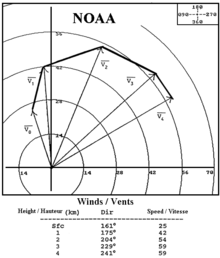
Hodograph plot of wind vectors at various heights in the troposphere. Meteorologists can use this plot to evaluate vertical wind shear in weather forecasting. (Source: NOAA)

The speed of sound varies with temperature. Since temperature and sound velocity normally decrease with increasing altitude, sound is refracted upward, away from listeners on the ground, producing an acoustic shadow at some distance from the source. In 1862, during the American Civil War Battle of Iuka, an acoustic shadow, believed to have been enhanced by a northeast wind, kept two divisions of Union soldiers out of the battle, because they could not hear the sounds of battle only six miles downwind.

Effects on architecture

Wind engineering is a field of engineering devoted to the analysis of wind effects on the natural and built environment. It includes strong winds which may cause discomfort as well as extreme winds such as tornadoes, hurricanes, and storms which may cause widespread destruction. Wind engineering draws upon meteorology, aerodynamics, and several specialist engineering disciplines. The tools used include climate models, atmospheric boundary layer wind tunnels, and numerical models. It involves, among other topics, how wind impacting buildings must be accounted for in engineering.

Wind turbines are affected by wind shear. Vertical wind-speed profiles result in different wind speeds at the blades nearest to the ground level compared to those at the top of blade travel, and this, in turn, affects the turbine operation. This low-level wind shear can cause a large bending moment in the shaft of a two-bladed turbine when the blades are vertical. The reduced wind shear over water means shorter and less expensive wind turbine towers can be used in shallow seas.

Earth's outer core

From Wikipedia, the free encyclopedia
https://en.wikipedia.org/wiki/Earth%27s_outer_core

Earth and atmosphere structure

Earth's outer core is a fluid layer about 2,260 km (1,400 mi) thick, composed of mostly iron and nickel that lies above Earth's solid inner core and below its mantle. The outer core begins approximately 2,889 km (1,795 mi) beneath Earth's surface at the core-mantle boundary and ends 5,150 km (3,200 mi) beneath Earth's surface at the inner core boundary.

Properties

Unlike Earth's solid, inner core, its outer core is liquid. Evidence for a fluid outer core includes seismology which shows that seismic shear-waves are not transmitted through the outer core. Although having a composition similar to Earth's solid inner core, the outer core remains liquid as there is not enough pressure to keep it in a solid state.

Seismic inversions of body waves and normal modes constrain the radius of the outer core to be 3483 km with an uncertainty of 5 km, while that of the inner core is 1220±10 km.

Estimates for the temperature of the outer core are about 3,000–4,500 K (2,700–4,200 °C; 4,900–7,600 °F) in its outer region and 4,000–8,000 K (3,700–7,700 °C; 6,700–14,000 °F) near the inner core. Modeling has shown that the outer core, because of its high temperature, is a low-viscosity fluid that convects turbulently. The dynamo theory sees eddy currents in the nickel-iron fluid of the outer core as the principal source of Earth's magnetic field. The average magnetic field strength in Earth's outer core is estimated to be 2.5 millitesla, 50 times stronger than the magnetic field at the surface.

As Earth's core cools, the liquid at the inner core boundary freezes, causing the solid inner core to grow at the expense of the outer core, at an estimated rate of 1 mm per year. This is approximately 80,000 tonnes of iron per second.

Light elements of Earth's outer core

Composition

Earth's outer core cannot be entirely constituted of iron or iron-nickel alloy because their densities are higher than geophysical measurements of the density of Earth's outer core. In fact, Earth's outer core is approximately 5 to 10 percent lower density than iron at Earth's core temperatures and pressures. Hence it has been proposed that light elements with low atomic numbers comprise part of Earth's outer core, as the only feasible way to lower its density. Although Earth's outer core is inaccessible to direct sampling, the composition of light elements can be meaningfully constrained by high-pressure experiments, calculations based on seismic measurements, models of Earth's accretion, and carbonaceous chondrite meteorite comparisons with bulk silicate Earth (BSE). Recent estimates are that Earth's outer core is composed of iron along with 0 to 0.26 percent hydrogen, 0.2 percent carbon, 0.8 to 5.3 percent oxygen, 0 to 4.0 percent silicon, 1.7 percent sulfur, and 5 percent nickel by weight, and the temperature of the core-mantle boundary and the inner core boundary ranges from 4,137 to 4,300 K and from 5,400 to 6,300 K respectively.

Constraints

Accretion
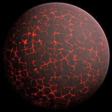
An artist's illustration of what Earth might have looked like early in its formation. In this image, the Earth looks molten, with red gaps of lava separating with jagged and seemingly-cooled plates of material.
An artist's illustration of what Earth might have looked like early in its formation.

The variety of light elements present in Earth's outer core is constrained in part by Earth's accretion. Namely, the light elements contained must have been abundant during Earth's formation, must be able to partition into liquid iron at low pressures, and must not volatilize and escape during Earth's accretionary process.

CI chondrites

CI chondritic meteorites are believed to contain the same planet-forming elements in the same proportions as in the early Solar System, so differences between CI meteorites and BSE can provide insights into the light element composition of Earth's outer core. For instance, the depletion of silicon in BSE compared to CI meteorites may indicate that silicon was absorbed into Earth's core; however, a wide range of silicon concentrations in Earth's outer and inner core is still possible.

Implications for Earth's accretion and core formation history

Tighter constraints on the concentrations of light elements in Earth's outer core would provide a better understanding of Earth's accretion and core formation history.

Consequences for Earth's accretion

Models of Earth's accretion could be better tested if we had better constraints on light element concentrations in Earth's outer core. For example, accretionary models based on core-mantle element partitioning tend to support proto-Earths constructed from reduced, condensed, and volatile-free material, despite the possibility that oxidized material from the outer Solar System was accreted towards the conclusion of Earth's accretion. If we could better constrain the concentrations of hydrogen, oxygen, and silicon in Earth's outer core, models of Earth's accretion that match these concentrations would presumably better constrain Earth’s formation.

Consequences for Earth's core formation

A diagram of Earth's differentiation. The diagram displays Earth's different layers and how dense materials move towards Earth's core.
A diagram of Earth's differentiation. The light elements sulfur, silicon, oxygen, carbon, and hydrogen may constitute part of the outer core due to their abundance and ability to partition into liquid iron under certain conditions.

The depletion of siderophile elements in Earth's mantle compared to chondritic meteorites is attributed to metal-silicate reactions during formation of Earth's core. These reactions are dependent on oxygen, silicon, and sulfur, so better constraints on concentrations of these elements in Earth's outer core will help elucidate the conditions of formation of Earth's core.

In another example, the possible presence of hydrogen in Earth's outer core suggests that the accretion of Earth’s water was not limited to the final stages of Earth's accretion and that water may have been absorbed into core-forming metals through a hydrous magma ocean.

Implications for Earth's magnetic field

A diagram of Earth's geodynamo and magnetic field, which could have been driven in Earth's early history by the crystallization of magnesium oxide, silicon dioxide, and iron(II) oxide. Convection of Earth's outer core is displayed alongside magnetic field lines.
A diagram of Earth's geodynamo and magnetic field, which could have been driven in Earth's early history by the crystallization of magnesium oxide, silicon dioxide, and iron(II) oxide.

Earth's magnetic field is driven by thermal convection and also by chemical convection, the exclusion of light elements from the inner core, which float upward within the fluid outer core while denser elements sink. This chemical convection releases gravitational energy that is then available to power the geodynamo that produces Earth's magnetic field. Carnot efficiencies with large uncertainties suggest that compositional and thermal convection contribute about 80 percent and 20 percent respectively to the power of Earth's geodynamo. Traditionally it was thought that prior to the formation of Earth's inner core, Earth's geodynamo was mainly driven by thermal convection. However, recent claims that the thermal conductivity of iron at core temperatures and pressures is much higher than previously thought imply that core cooling was largely by conduction not convection, limiting the ability of thermal convection to drive the geodynamo. This conundrum is known as the new "core paradox." An alternative process that could have sustained Earth's geodynamo requires Earth's core to have initially been hot enough to dissolve oxygen, magnesium, silicon, and other light elements. As the Earth's core began to cool, it would become supersaturated in these light elements that would then precipitate into the lower mantle forming oxides leading to a different variant of chemical convection.

Internal structure of Earth

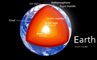
Geological cross section of Earth, showing its internal structure, the atmosphere and hydrosphere.

The internal structure of Earth is the solid portion of the Earth, excluding its atmosphere and hydrosphere. The structure consists of an outer silicate solid crust, a highly viscous asthenosphere and solid mantle, a liquid outer core whose flow generates the Earth's magnetic field, and a solid inner core.

Scientific understanding of the internal structure of Earth is based on observations of topography and bathymetry, observations of rock in outcrop, samples brought to the surface from greater depths by volcanoes or volcanic activity, analysis of the seismic waves that pass through Earth, measurements of the gravitational and magnetic fields of Earth, and experiments with crystalline solids at pressures and temperatures characteristic of Earth's deep interior.

Global properties

see caption
A photograph of Earth taken by the crew of Apollo 17 in 1972. A processed version became widely known as The Blue Marble.

Measurements of the force exerted by Earth's gravity can be used to calculate its mass. Astronomers can also calculate Earth's mass by observing the motion of orbiting satellites. Earth's average density can be determined through gravimetric experiments, which have historically involved pendulums. The mass of Earth is about 6×1024 kg. The average density of the Earth is 5.515 g/cm3.

Layers

The structure of Earth can be defined in two ways: by mechanical properties such as rheology, or chemically. Mechanically, it can be divided into lithosphere, asthenosphere, mesospheric mantle, outer core, and the inner core. Chemically, Earth can be divided into the crust, upper mantle, lower mantle, outer core, and inner core. The geologic component layers of Earth are at increasing depths below the surface.

Crust and lithosphere

Map of Earth's tectonic plates
Earth's major plates, which are:

The Earth's crust ranges from 5–70 kilometres (3.1–43.5 mi) in depth and is the outermost layer. The thin parts are the oceanic crust, which underlie the ocean basins (5–10 km) and is mafic-rich (dense iron-magnesium silicate mineral or igneous rock). The thicker crust is the continental crust, which is less dense and is felsic-rich (igneous rocks rich in elements that form feldspar and quartz). The rocks of the crust fall into two major categories – sial (aluminium silicate) and sima (magnesium silicate). It is estimated that sima starts about 11 km below the Conrad discontinuity, though the discontinuity is not distinct and can be absent in some continental regions.

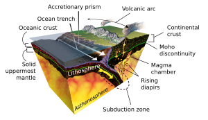
The Earth's lithosphere consists of the crust and the uppermost mantle. The crust-mantle boundary occurs as two physically different phenomena. The Mohorovičić discontinuity is a distinct change of seismic wave velocity. This is caused by a change in the rock's density – Immediately above the Moho, the velocities of primary seismic waves (P wave) are consistent with those through basalt (6.7–7.2 km/s), and below they are similar to those through peridotite or dunite (7.6–8.6 km/s). Second, in oceanic crust, there is a chemical discontinuity between ultramafic cumulates and tectonized harzburgites, which has been observed from deep parts of the oceanic crust that have been obducted onto the continental crust and preserved as ophiolite sequences.

Many rocks making up Earth's crust formed less than 100 million years ago; however, the oldest known mineral grains are about 4.4 billion years old, indicating that Earth has had a solid crust for at least 4.4 billion years.

Mantle

Earth's crust and mantle, Mohorovičić discontinuity between bottom of crust and solid uppermost mantle

Earth's mantle extends to a depth of 2,890 km (1,800 mi), making it the planet's thickest layer. [This is 45% of the 6,371 km (3,959 mi) radius, and 83.7% of the volume - 0.6% of the volume is the crust]. The mantle is divided into upper and lower mantle separated by a transition zone. The lowest part of the mantle next to the core-mantle boundary is known as the D″ (D-double-prime) layer. The pressure at the bottom of the mantle is ≈140 GPa (1.4 Matm). The mantle is composed of silicate rocks richer in iron and magnesium than the overlying crust. Although solid, the mantle's extremely hot silicate material can flow over very long timescales. Convection of the mantle propels the motion of the tectonic plates in the crust. The source of heat that drives this motion is the decay of radioactive isotopes in the Earth's crust and mantle combined with the initial heat from the planet's formation.

Due to increasing pressure deeper in the mantle, the lower part flows less easily, though chemical changes within the mantle may also be important. The viscosity of the mantle ranges between 1021 and 1024 pascal-second, increasing with depth. In comparison, the viscosity of water at 300 K (27 °C; 80 °F) is 0.89 pascal-second and pitch is (2.3 ± 0.5)8 pascal-second.

Core

A diagram of Earth's geodynamo and magnetic field, which could have been driven in Earth's early history by the crystallization of magnesium oxide, silicon dioxide, and iron(II) oxide. Convection of Earth's outer core is displayed alongside magnetic field lines.
A diagram of Earth's geodynamo and magnetic field, which could have been driven in Earth's early history by the crystallization of magnesium oxide, silicon dioxide, and iron(II) oxide.

Earth's outer core is a fluid layer about 2,400 km (1,500 mi) in diameter [19% of the Earth's diameter, 15.6% of the volume] and composed of mostly iron and nickel that lies above Earth's solid inner core and below its mantle. Its outer boundary lies 2,890 km (1,800 mi) beneath Earth's surface. The transition between the inner core and outer core is located approximately 5,150 km (3,200 mi) beneath the Earth's surface. Earth's inner core is the innermost geologic layer of the planet Earth. It is primarily a solid ball with a radius of about 1,220 km (760 mi), which is about 19% of Earth's radius [0.7% of volume] or 70% of the Moon's radius.

The inner core was discovered in 1936 by Inge Lehmann and is generally composed primarily of iron and some nickel. Since this layer is able to transmit shear waves (transverse seismic waves), it must be solid. Experimental evidence has at times been inconsistent with current crystal models of the core. Other experimental studies show a discrepancy under high pressure: diamond anvil (static) studies at core pressures yield melting temperatures that are approximately 2000 K below those from shock laser (dynamic) studies. The laser studies create plasma, and the results are suggestive that constraining inner core conditions will depend on whether the inner core is a solid or is a plasma with the density of a solid. This is an area of active research.

In early stages of Earth's formation about 4.6 billion years ago, melting would have caused denser substances to sink toward the center in a process called planetary differentiation (see also the iron catastrophe), while less-dense materials would have migrated to the crust. The core is thus believed to largely be composed of iron (80%), along with nickel and one or more light elements, whereas other dense elements, such as lead and uranium, either are too rare to be significant or tend to bind to lighter elements and thus remain in the crust (see felsic materials). Some have argued that the inner core may be in the form of a single iron crystal.

Under laboratory conditions a sample of iron–nickel alloy was subjected to the corelike pressures by gripping it in a vise between 2 diamond tips (diamond anvil cell), and then heating to approximately 4000 K. The sample was observed with x-rays, and strongly supported the theory that Earth's inner core was made of giant crystals running north to south.

The composition of the Earth bears strong similarities to that of certain chondrite meteorites, and even to some elements in the outer portion of the Sun. Beginning as early as 1940, scientists, including Francis Birch, built geophysics upon the premise that Earth is like ordinary chondrites, the most common type of meteorite observed impacting Earth. This ignores the less abundant enstatite chondrites, which formed under extremely limited available oxygen, leading to certain normally oxyphile elements existing either partially or wholly in the alloy portion that corresponds to the core of Earth.

Dynamo theory suggests that convection in the outer core, combined with the Coriolis effect, gives rise to Earth's magnetic field. The solid inner core is too hot to hold a permanent magnetic field (see Curie temperature) but probably acts to stabilize the magnetic field generated by the liquid outer core. The average magnetic field in Earth's outer core is estimated to measure 2.5 mT (25 G), 50 times stronger than the magnetic field at the surface.

Seismology

The layering of Earth has been inferred indirectly using the time of travel of refracted and reflected seismic waves created by earthquakes. The core does not allow shear waves to pass through it, while the speed of travel (seismic velocity) is different in other layers. The changes in seismic velocity between different layers causes refraction owing to Snell's law, like light bending as it passes through a prism. Likewise, reflections are caused by a large increase in seismic velocity and are similar to light reflecting from a mirror.

Introduction to entropy

From Wikipedia, the free encyclopedia https://en.wikipedia.org/wiki/Introduct...