Search This Blog

Wednesday, February 12, 2020

Lymphatic system

From Wikipedia, the free encyclopedia
https://en.wikipedia.org/wiki/Lymphatic_system
 
Lymphatic system
Blausen 0623 LymphaticSystem Female.png
Human lymphatic system
Details
Identifiers
Latinsystema lymphoideum
MeSHD008208
TAA13.0.00.000
FMA74594

The lymphatic system, or lymphoid system, is an organ system in vertebrates that is part of the circulatory system and the immune system. It is made up of a large network of lymphatic vessels, lymphatic or lymphoid organs, and lymphoid tissues. The vessels carry a clear fluid called lymph (the Latin word lympha refers to the deity of fresh water, "Lympha") towards the heart.

Unlike the circulatory system, the lymphatic system is not a closed system. The human circulatory system processes an average of 20 litres of blood per day through capillary filtration, which removes plasma from the blood. Roughly 17 litres of the filtered plasma is reabsorbed directly into the blood vessels, while the remaining three litres remain in the interstitial fluid. One of the main functions of the lymphatic system is to provide an accessory return route to the blood for the surplus three litres.

The other main function is that of immune defense. Lymph is very similar to blood plasma, in that it contains waste products and cellular debris, together with bacteria and proteins. The cells of the lymph are mostly lymphocytes. Associated lymphoid organs are composed of lymphoid tissue, and are the sites either of lymphocyte production or of lymphocyte activation. These include the lymph nodes (where the highest lymphocyte concentration is found), the spleen, the thymus, and the tonsils. Lymphocytes are initially generated in the bone marrow. The lymphoid organs also contain other types of cells such as stromal cells for support. Lymphoid tissue is also associated with mucosas such as mucosa-associated lymphoid tissue (MALT).

Fluid from circulating blood leaks into the tissues of the body by capillary action, carrying nutrients to the cells. The fluid bathes the tissues as interstitial fluid, collecting waste products, bacteria, and damaged cells, and then drains as lymph into the lymphatic capillaries and lymphatic vessels. These vessels carry the lymph throughout the body, passing through numerous lymph nodes which filter out unwanted materials such as bacteria and damaged cells. Lymph then passes into much larger lymph vessels known as lymph ducts. The right lymphatic duct drains the right side of the region and the much larger left lymphatic duct, known as the thoracic duct, drains the left side of the body. The ducts empty into the subclavian veins to return to the blood circulation. Lymph is moved through the system by muscle contractions. In some vertebrates, a lymph heart is present that pumps the lymph to the veins.

The lymphatic system was first described in the 17th century independently by Olaus Rudbeck and Thomas Bartholin.

Structure

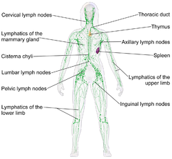
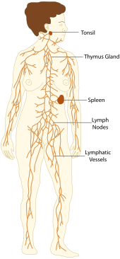
Diagram of vessels and organs in the lymphatic system

The lymphatic system consists of a conducting network of lymphatic vessels, lymphoid organs, lymphoid tissues, and the circulating lymph

Primary lymphoid organs

The primary (or central) lymphoid organs generate lymphocytes from immature progenitor cells. The thymus and the bone marrow constitute the primary lymphoid organs involved in the production and early clonal selection of lymphocyte tissues. 

Bone marrow

Bone marrow is responsible for both the creation of T cells and the production and maturation of B cells, which are important cell types of the immune system. From the bone marrow, B cells immediately join the circulatory system and travel to secondary lymphoid organs in search of pathogens. T cells, on the other hand, travel from the bone marrow to the thymus, where they develop further and mature. Mature T cells then join B cells in search of pathogens. The other 95% of T cells begin a process of apoptosis, a form of programmed cell death

Thymus

The thymus increases in size from birth in response to postnatal antigen stimulation. It is most active during the neonatal and pre-adolescent periods. At puberty, by the early teens, the thymus begins to atrophy and regress, with adipose tissue mostly replacing the thymic stroma. However, residual T lymphopoiesis continues throughout adult life. The loss or lack of the thymus results in severe immunodeficiency and subsequent high susceptibility to infection. In most species, the thymus consists of lobules divided by septa which are made up of epithelium; it is therefore often considered an epithelial organ. T cells mature from thymocytes, proliferate, and undergo a selection process in the thymic cortex before entering the medulla to interact with epithelial cells. 

The thymus provides an inductive environment for the development of T cells from hematopoietic progenitor cells. In addition, thymic stromal cells allow for the selection of a functional and self-tolerant T cell repertoire. Therefore, one of the most important roles of the thymus is the induction of central tolerance. 

Secondary lymphoid organs

The secondary (or peripheral) lymphoid organs (SLO), which include lymph nodes and the spleen, maintain mature naive lymphocytes and initiate an adaptive immune response. The peripheral lymphoid organs are the sites of lymphocyte activation by antigens. Activation leads to clonal expansion and affinity maturation. Mature lymphocytes recirculate between the blood and the peripheral lymphoid organs until they encounter their specific antigen.

Spleen

The main functions of the spleen are:
  1. to produce immune cells to fight antigens
  2. to remove particulate matter and aged blood cells, mainly red blood cells
  3. to produce blood cells during fetal life.
The spleen synthesizes antibodies in its white pulp and removes antibody-coated bacteria and antibody-coated blood cells by way of blood and lymph node circulation. A study published in 2009 using mice found that the spleen contains, in its reserve, half of the body's monocytes within the red pulp. These monocytes, upon moving to injured tissue (such as the heart), turn into dendritic cells and macrophages while promoting tissue healing. The spleen is a center of activity of the mononuclear phagocyte system and can be considered analogous to a large lymph node, as its absence causes a predisposition to certain infections.

Like the thymus, the spleen has only efferent lymphatic vessels. Both the short gastric arteries and the splenic artery supply it with blood. The germinal centers are supplied by arterioles called penicilliary radicles.

Until the fifth month of prenatal development, the spleen creates red blood cells; after birth, the bone marrow is solely responsible for hematopoiesis. As a major lymphoid organ and a central player in the reticuloendothelial system, the spleen retains the ability to produce lymphocytes. The spleen stores red blood cells and lymphocytes. It can store enough blood cells to help in an emergency. Up to 25% of lymphocytes can be stored at any one time.

Lymph nodes

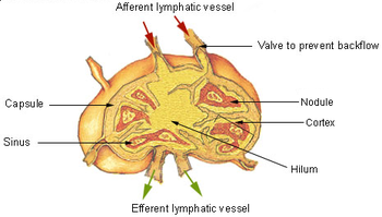
A lymph node showing afferent and efferent lymphatic vessels
 
Regional lymph nodes

A lymph node is an organized collection of lymphoid tissue, through which the lymph passes on its way back to the blood. Lymph nodes are located at intervals along the lymphatic system. Several afferent lymph vessels bring in lymph, which percolates through the substance of the lymph node, and is then drained out by an efferent lymph vessel. Of the nearly 800 lymph nodes in the human body, about 300 are located in the head and neck. Many are grouped in clusters in different regions, as in the underarm and abdominal areas. Lymph node clusters are commonly found at the proximal ends of limbs (groin, armpits) and in the neck, where lymph is collected from regions of the body likely to sustain pathogen contamination from injuries. Lymph nodes are particularly numerous in the mediastinum in the chest, neck, pelvis, axilla, inguinal region, and in association with the blood vessels of the intestines.

The substance of a lymph node consists of lymphoid follicles in an outer portion called the cortex. The inner portion of the node is called the medulla, which is surrounded by the cortex on all sides except for a portion known as the hilum. The hilum presents as a depression on the surface of the lymph node, causing the otherwise spherical lymph node to be bean-shaped or ovoid. The efferent lymph vessel directly emerges from the lymph node at the hilum. The arteries and veins supplying the lymph node with blood enter and exit through the hilum. The region of the lymph node called the paracortex immediately surrounds the medulla. Unlike the cortex, which has mostly immature T cells, or thymocytes, the paracortex has a mixture of immature and mature T cells. Lymphocytes enter the lymph nodes through specialised high endothelial venules found in the paracortex. 

A lymph follicle is a dense collection of lymphocytes, the number, size, and configuration of which change in accordance with the functional state of the lymph node. For example, the follicles expand significantly when encountering a foreign antigen. The selection of B cells, or B lymphocytes, occurs in the germinal centre of the lymph nodes. 

Secondary lymphoid tissue provides the environment for the foreign or altered native molecules (antigens) to interact with the lymphocytes. It is exemplified by the lymph nodes, and the lymphoid follicles in tonsils, Peyer's patches, spleen, adenoids, skin, etc. that are associated with the mucosa-associated lymphoid tissue (MALT).

In the gastrointestinal wall, the appendix has mucosa resembling that of the colon, but here it is heavily infiltrated with lymphocytes. 

Tertiary lymphoid organs

Tertiary lymphoid organs (TLOs) are abnormal lymph node-like structures that form in peripheral tissues at sites of chronic inflammation, such as chronic infection, transplanted organs undergoing graft rejection, some cancers, and autoimmune and autoimmune-related diseases. TLOs are regulated differently from the normal process whereby lymphoid tissues are formed during ontogeny, being dependent on cytokines and hematopoietic cells, but still drain interstitial fluid and transport lymphocytes in response to the same chemical messengers and gradients. TLOs typically contain far fewer lymphocytes, and assume an immune role only when challenged with antigens that result in inflammation. They achieve this by importing the lymphocytes from blood and lymph.

Other lymphoid tissue

Lymphoid tissue associated with the lymphatic system is concerned with immune functions in defending the body against infections and the spread of tumours. It consists of connective tissue formed of reticular fibers, with various types of leukocytes (white blood cells), mostly lymphocytes enmeshed in it, through which the lymph passes. Regions of the lymphoid tissue that are densely packed with lymphocytes are known as lymphoid follicles. Lymphoid tissue can either be structurally well organized as lymph nodes or may consist of loosely organized lymphoid follicles known as the mucosa-associated lymphoid tissue.

The central nervous system also has lymphatic vessels. The search for T cell gateways into and out of the meninges uncovered functional meningeal lymphatic vessels lining the dural sinuses, anatomically integrated into the membrane surrounding the brain.

Lymphatic vessels

Lymph capillaries in the tissue spaces

The lymphatic vessels, also called lymph vessels, are thin-walled vessels that conduct lymph between different parts of the body. They include the tubular vessels of the lymph capillaries, and the larger collecting vessels–the right lymphatic duct and the thoracic duct (the left lymphatic duct). The lymph capillaries are mainly responsible for the absorption of interstitial fluid from the tissues, while lymph vessels propel the absorbed fluid forward into the larger collecting ducts, where it ultimately returns to the bloodstream via one of the subclavian veins

The tissues of the lymphatic system are responsible for maintaining the balance of the body fluids. Its network of capillaries and collecting lymphatic vessels work to efficiently drain and transport extravasated fluid, along with proteins and antigens, back to the circulatory system. Numerous intraluminal valves in the vessels ensure a unidirectional flow of lymph without reflux. Two valve systems, a primary and a secondary valve system, are used to achieve this unidirectional flow. The capillaries are blind-ended, and the valves at the ends of capillaries use specialised junctions together with anchoring filaments to allow a unidirectional flow to the primary vessels. The collecting lymphatics, however, act to propel the lymph by the combined actions of the intraluminal valves and lymphatic muscle cells.

Development

Lymphatic tissues begin to develop by the end of the fifth week of embryonic development. Lymphatic vessels develop from lymph sacs that arise from developing veins, which are derived from mesoderm

The first lymph sacs to appear are the paired jugular lymph sacs at the junction of the internal jugular and subclavian veins. From the jugular lymph sacs, lymphatic capillary plexuses spread to the thorax, upper limbs, neck and head. Some of the plexuses enlarge and form lymphatic vessels in their respective regions. Each jugular lymph sac retains at least one connection with its jugular vein, the left one developing into the superior portion of the thoracic duct.

The next lymph sac to appear is the unpaired retroperitoneal lymph sac at the root of the mesentery of the intestine. It develops from the primitive vena cava and mesonephric veins. Capillary plexuses and lymphatic vessels spread from the retroperitoneal lymph sac to the abdominal viscera and diaphragm. The sac establishes connections with the cisterna chyli but loses its connections with neighbouring veins. 

The last of the lymph sacs, the paired posterior lymph sacs, develop from the iliac veins. The posterior lymph sacs produce capillary plexuses and lymphatic vessels of the abdominal wall, pelvic region, and lower limbs. The posterior lymph sacs join the cisterna chyli and lose their connections with adjacent veins.

With the exception of the anterior part of the sac from which the cisterna chyli develops, all lymph sacs become invaded by mesenchymal cells and are converted into groups of lymph nodes. 

The spleen develops from mesenchymal cells between layers of the dorsal mesentery of the stomach. The thymus arises as an outgrowth of the third pharyngeal pouch. 

Function

The lymphatic system has multiple interrelated functions:

Fat absorption

Nutrients in food are absorbed via intestinal vili (greatly enlarged in the picture) to blood and lymph. Long-chain fatty acids (and other lipids with similar fat solubility like some medicines) are absorbed to the lymph and move in it enveloped inside chylomicrons. They move via the thoracic duct of the lymphatic system and finally enter the blood via the left subclavian vein, thus bypassing the liver's first-pass metabolism completely.
 
Lymph vessels called lacteals are at the beginning of the gastrointestinal tract, predominantly in the small intestine. While most other nutrients absorbed by the small intestine are passed on to the portal venous system to drain via the portal vein into the liver for processing, fats (lipids) are passed on to the lymphatic system to be transported to the blood circulation via the thoracic duct. (There are exceptions, for example medium-chain triglycerides are fatty acid esters of glycerol that passively diffuse from the GI tract to the portal system.) The enriched lymph originating in the lymphatics of the small intestine is called chyle. The nutrients that are released into the circulatory system are processed by the liver, having passed through the systemic circulation. 

Immune function

The lymphatic system plays a major role in the body's immune system, as the primary site for cells relating to adaptive immune system including T-cells and B-cells. Cells in the lymphatic system react to antigens presented or found by the cells directly or by other dendritic cells. When an antigen is recognized, an immunological cascade begins involving the activation and recruitment of more and more cells, the production of antibodies and cytokines and the recruitment of other immunological cells such as macrophages

Clinical significance

The study of lymphatic drainage of various organs is important in the diagnosis, prognosis, and treatment of cancer. The lymphatic system, because of its closeness to many tissues of the body, is responsible for carrying cancerous cells between the various parts of the body in a process called metastasis. The intervening lymph nodes can trap the cancer cells. If they are not successful in destroying the cancer cells the nodes may become sites of secondary tumours. 

Enlarged lymph nodes

Lymphadenopathy refers to one or more enlarged lymph nodes. Small groups or individually enlarged lymph nodes are generally reactive in response to infection or inflammation. This is called local lymphadenopathy. When many lymph nodes in different areas of the body are involved, this is called generalised lymphadenopathy. Generalised lymphadenopathy may be caused by infections such as infectious mononucleosis, tuberculosis and HIV, connective tissue diseases such as SLE and rheumatoid arthritis, and cancers, including both cancers of tissue within lymph nodes, discussed below, and metastasis of cancerous cells from other parts of the body, that have arrived via the lymphatic system.

Lymphedema

Lymphedema is the swelling caused by the accumulation of lymph, which may occur if the lymphatic system is damaged or has malformations. It usually affects limbs, though the face, neck and abdomen may also be affected. In an extreme state, called elephantiasis, the edema progresses to the extent that the skin becomes thick with an appearance similar to the skin on elephant limbs.

Causes are unknown in most cases, but sometimes there is a previous history of severe infection, usually caused by a parasitic disease, such as lymphatic filariasis.

Lymphangiomatosis is a disease involving multiple cysts or lesions formed from lymphatic vessels.

Lymphedema can also occur after surgical removal of lymph nodes in the armpit (causing the arm to swell due to poor lymphatic drainage) or groin (causing swelling of the leg). Conventional treatment is by manual lymphatic drainage and compression garments. Two drugs for the treatment of lymphedema are in clinical trials: Lymfactin and Ubenimex/Bestatin

There is no evidence to suggest that the effects of manual lymphatic drainage are permanent.

Cancer

Cancer of the lymphatic system can be primary or secondary. Lymphoma refers to cancer that arises from lymphatic tissue. Lymphoid leukaemias and lymphomas are now considered to be tumours of the same type of cell lineage. They are called "leukaemia" when in the blood or marrow and "lymphoma" when in lymphatic tissue. They are grouped together under the name "lymphoid malignancy".

Lymphoma is generally considered as either Hodgkin lymphoma or non-Hodgkin lymphoma. Hodgkin lymphoma is characterised by a particular type of cell, called a Reed–Sternberg cell, visible under microscope. It is associated with past infection with the Epstein–Barr virus, and generally causes a painless "rubbery" lymphadenopathy. It is staged, using Ann Arbor staging. Chemotherapy generally involves the ABVD and may also involve radiotherapy. Non-Hodgkin lymphoma is a cancer characterised by increased proliferation of B-cells or T-cells, generally occurs in an older age group than Hodgkin lymphoma. It is treated according to whether it is high-grade or low-grade, and carries a poorer prognosis than Hodgkin lymphoma.

Lymphangiosarcoma is a malignant soft tissue tumour, whereas lymphangioma is a benign tumour occurring frequently in association with Turner syndrome. Lymphangioleiomyomatosis is a benign tumour of the smooth muscles of the lymphatics that occurs in the lungs.

Lymphoid leukaemia is another form of cancer where the host is devoid of different lymphatic cells. 

Other


History

Hippocrates, in the 5th century BC, was one of the first people to mention the lymphatic system. In his work On Joints, he briefly mentioned the lymph nodes in one sentence. Rufus of Ephesus, a Roman physician, identified the axillary, inguinal and mesenteric lymph nodes as well as the thymus during the 1st to 2nd century AD. The first mention of lymphatic vessels was in the 3rd century BC by Herophilos, a Greek anatomist living in Alexandria, who incorrectly concluded that the "absorptive veins of the lymphatics," by which he meant the lacteals (lymph vessels of the intestines), drained into the hepatic portal veins, and thus into the liver. The findings of Ruphus and Herophilos were further propagated by the Greek physician Galen, who described the lacteals and mesenteric lymph nodes which he observed in his dissection of apes and pigs in the 2nd century AD.

In the mid 16th century, Gabriele Falloppio (discoverer of the fallopian tubes), described what is now known as the lacteals as "coursing over the intestines full of yellow matter." In about 1563 Bartolomeo Eustachi, a professor of anatomy, described the thoracic duct in horses as vena alba thoracis. The next breakthrough came when in 1622 a physician, Gaspare Aselli, identified lymphatic vessels of the intestines in dogs and termed them venue alba et lacteal, which is now known as simply the lacteals. The lacteals were termed the fourth kind of vessels (the other three being the artery, vein and nerve, which was then believed to be a type of vessel), and disproved Galen's assertion that chyle was carried by the veins. But, he still believed that the lacteals carried the chyle to the liver (as taught by Galen). He also identified the thoracic duct but failed to notice its connection with the lacteals. This connection was established by Jean Pecquet in 1651, who found a white fluid mixing with blood in a dog's heart. He suspected that fluid to be chyle as its flow increased when abdominal pressure was applied. He traced this fluid to the thoracic duct, which he then followed to a chyle-filled sac he called the chyli receptaculum, which is now known as the cisternae chyli; further investigations led him to find that lacteals' contents enter the venous system via the thoracic duct. Thus, it was proven convincingly that the lacteals did not terminate in the liver, thus disproving Galen's second idea: that the chyle flowed to the liver. Johann Veslingius drew the earliest sketches of the lacteals in humans in 1647.

The idea that blood recirculates through the body rather than being produced anew by the liver and the heart was first accepted as a result of works of William Harvey—a work he published in 1628. In 1652, Olaus Rudbeck (1630–1702), a Swede, discovered certain transparent vessels in the liver that contained clear fluid (and not white), and thus named them hepatico-aqueous vessels. He also learned that they emptied into the thoracic duct and that they had valves. He announced his findings in the court of Queen Christina of Sweden, but did not publish his findings for a year, and in the interim similar findings were published by Thomas Bartholin, who additionally published that such vessels are present everywhere in the body, not just in the liver. He is also the one to have named them "lymphatic vessels." This had resulted in a bitter dispute between one of Bartholin's pupils, Martin Bogdan, and Rudbeck, whom he accused of plagiarism.

Galen's ideas prevailed in medicine until the 17th century. It was thought that blood was produced by the liver from chyle contaminated with ailments by the intestine and stomach, to which various spirits were added by other organs, and that this blood was consumed by all the organs of the body. This theory required that the blood be consumed and produced many times over. Even in the 17th century, his ideas were defended by some physicians.

Alexander Monro, of the University of Edinburgh Medical School, was the first to describe the function of the lymphatic system in detail.
Missoula floods

From Wikipedia, the free encyclopedia
 
Missoula floods
Wpdms nasa topo missoula floods.jpg
Glacial Lake Columbia (west) and Glacial Lake Missoula (east) are shown south of Cordilleran ice sheet. The areas inundated in the Columbia and Missoula floods are shown in red.
DateBetween 15,000 and 13,000 years ago
LocationThe current states of: Idaho, Washington, and Oregon
CauseIce dam ruptures

The Missoula floods (also known as the Spokane floods or the Bretz floods or Bretz's floods) refer to the cataclysmic floods that swept periodically across eastern Washington and down the Columbia River Gorge at the end of the last ice age. The glacial flood events have been researched since the 1920s. These glacial lake outburst floods were the result of periodic sudden ruptures of the ice dam on the Clark Fork River that created Glacial Lake Missoula. After each ice dam rupture, the waters of the lake would rush down the Clark Fork and the Columbia River, flooding much of eastern Washington and the Willamette Valley in western Oregon. After the rupture, the ice would reform, creating Glacial Lake Missoula again.

During the last deglaciation that followed the end of the Last Glacial Maximum, geologists estimate that a cycle of flooding and reformation of the lake lasted an average of 55 years and that the floods occurred several times over the 2,000-year period between 15,000 and 13,000 years ago. U.S. Geological Survey hydrologist Jim O'Connor and Spanish Center of Environmental Studies scientist Gerard Benito have found evidence of at least twenty-five massive floods, the largest discharging about 10 cubic kilometers per hour (2.7 million m³/s, 13 times the Amazon River). Alternate estimates for the peak flow rate of the largest flood include 17 cubic kilometers per hour and range up to 60 cubic kilometers per hour. The maximum flow speed approached 36 meters/second (130 km/h or 80 mph).

Within the Columbia River drainage basin, detailed investigation of the Missoula floods' glaciofluvial deposits, informally known as the Hanford formation, has documented the presence of Middle and Early Pleistocene Missoula flood deposits within the Othello Channels, Columbia River Gorge, Channeled Scabland, Quincy Basin, Pasco Basin, and the Walla Walla Valley. Based on the presence of multiple interglacial calcretes interbedded with flood deposits, magnetostratigraphy, optically stimulated luminescence dating, and unconformity truncated clastic dikes, it has been estimated that the oldest of the Pleistocene Missoula floods happened before 1.5 million years ago. Because of the fragmentary nature of older glaciofluvial deposits, which have been largely removed by subsequent Missoula floods, within the Hanford formation, the exact number of older Missoula floods, which are known as ancient cataclysmic floods, that occurred during the Pleistocene cannot be estimated with any confidence.

Flood hypothesis proposed

The Channeled Scablands of eastern Washington

Geologist J Harlen Bretz first recognized evidence of the catastrophic floods, which he called the Spokane floods, in the 1920s. He was researching the Channeled Scablands in Eastern Washington, the Columbia Gorge, and the Willamette Valley of Oregon. In the summer of 1922, and for the next seven years, Bretz conducted field research of the Columbia River Plateau. He had been interested in unusual erosion features in the area since 1910 after seeing a newly published topographic map of the Potholes Cataract. Bretz coined the term Channeled Scablands in 1923 to refer to the area near the Grand Coulee, where massive erosion had cut through basalt deposits. Bretz published a paper in 1923, arguing that the Channeled Scablands in Eastern Washington were caused by massive flooding in the distant past.

Bretz's view, which was seen as arguing for a catastrophic explanation of the geology, ran against the prevailing view of uniformitarianism, and Bretz's views were initially disregarded. The Geological Society of Washington, D.C, invited the young Bretz to present his previously published research at a January 12, 1927 meeting where several other geologists presented competing theories. Another geologist at the meeting, J.T. Pardee, had worked with Bretz and had evidence of an ancient glacial lake that lent credence to Bretz's theories. Bretz defended his theories, and this kicked off an acrimonious 40-year debate over the origin of the Scablands. Both Pardee and Bretz continued their research over the next 30 years, collecting and analyzing evidence that led them to identify Lake Missoula as the source of the Spokane flood and creator of the channeled scablands.

After Pardee studied the canyon of the Flathead River, he estimated that flood waters in excess of 45 miles per hour (72 km/h) would be required to roll the largest of the boulders moved by the flood. He estimated the water flow was 9 cubic miles per hour (38 km3/h), more than the combined flow of every river in the world. Estimates place the flow rate at ten times the flow of all current rivers combined.

The Missoula floods have also been referred to as the Bretz floods in honor of Bretz.

Flood initiation

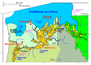
  Cordilleran ice sheet
  maximum extent of Glacial Lake Missoula (eastern) and Glacial Lake Columbia (western)
  areas swept by Missoula and Columbia floods

As the depth of the water in Lake Missoula increased, the pressure at the bottom of the ice dam increased enough to lower the freezing point of water below the temperature of the ice forming the dam. This allowed liquid water to seep into minuscule cracks present in the ice dam. Over a period of time, the friction from water flowing through these cracks generated enough heat to melt the ice walls and enlarge the cracks. This allowed more water to flow through the cracks, generating more heat, allowing even more water to flow through the cracks. This feedback cycle eventually weakened the ice dam so much that it could no longer support the pressure of the water behind it, and it failed catastrophically. This process is known as a glacial lake outburst flood, and many such events have occurred in recorded history.

Flood events

As the water emerged from the Columbia River gorge, it backed up again at the 1 mile (1.6 km) wide narrows near Kalama, Washington. Some temporary lakes rose to an elevation of more than 400 ft (120 m), flooding the Willamette Valley to Eugene, Oregon and beyond. Iceberg rafted glacial erratics and erosion features are evidence of these events. Lake-bottom sediments deposited by the floods have contributed to the agricultural richness of the Willamette and Columbia Valleys. Glacial deposits overlaid with centuries of windblown sediments (loess) have scattered steep, southerly-sloping dunes throughout the Columbia Valley, ideal conditions for orchard and vineyard development at higher latitudes.

After analysis and controversy, geologists now believe that there were 40 or more separate floods, although the exact source of the water is still being debated. The peak flow of the floods is estimated to be 40 to 60 cubic kilometers per hour (9.5 to 15 cubic miles per hour). The maximum flow speed approached 36 meters/second (130 km/h or 80 mph). Up to 1.9×10¹⁹ joules of potential energy were released by each flood (the equivalent of 4,500 megatons of TNT). The cumulative effect of the floods was to excavate 210 cubic kilometres (50 cu mi) of loess, sediment and basalt from the Channeled Scablands of eastern Washington and to transport it downstream.

Multiple flood hypothesis

During the ice age floods, Dry Falls was under 300 feet (91 m) of water approaching at a speed of 65 miles per hour (105 km/h).
 
The multiple flood hypothesis was first proposed by R.B. Waitt, Jr. in 1980. Waitt argued for a sequence of multiple floods — 40 or more. Waitt's proposal was based mainly on analysis from glacial lake bottom deposits in Ninemile Creek and the flood deposits in Burlingame Canyon. His most compelling argument for separate floods was that the Touchet bed deposits from two successive floods were found to be separated by two layers of volcanic ash (tephra) with the ash separated by a fine layer of windblown dust deposits, located in a thin layer between sediment layers ten rhythmites below the top of the Touchet beds. The two layers of volcanic ash are separated by 1–10 centimetres (0.4–3.9 in) of airborne nonvolcanic silt. The tephra is Mount St. Helens ash that fell in Eastern Washington. By analogy, since there were 40 layers with comparable characteristics at Burlingame Canyon, Waitt argued they all could be considered to have similar separation in deposition time.

Controversy over number and source of floods

The controversy whether the Channeled Scabland landforms were formed mainly by multiple periodic floods, or by a single grand-scale cataclysmic flood from late Pleistocene Glacial Lake Missoula or from an unidentified Canadian source, continued through 1999. Shaw's team of geologists reviewed the sedimentary sequences of the Touchet beds and concluded that the sequences do not automatically imply multiple floods separated by decades or centuries. Rather, they proposed that sedimentation in the Glacial Lake Missoula basin was the result of jökulhlaups draining into Lake Missoula from British Columbia to the north. Further, Shaw's team proposed the scabland flooding might have partially originated from an enormous subglacial reservoir that extended over much of central British Columbia, particularly including the Rocky Mountain Trench, which may have discharged by several paths, including one through Lake Missoula. This discharge, if occurring concurrently with the breach of the Lake Missoula ice dam, would have provided significantly larger volumes of water. Further, Shaw and team proposed that the rhythmic Touchet beds are the result of multiple pulses, or surges, within a single larger flood.

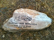
Glacial Lake Missoula high-water mark, 4,200 feet (1,280 m), near Missoula, MT
 
In 2000, a team led by Komatsu simulated the floods numerically with a 3-dimensional hydraulic model. They based the Glacial Lake Missoula discharge rate on the rate predicted for the Spokane ValleyRathdrum Prairie immediately downstream of Glacial Lake Missoula, for which a number of previous estimates had placed the maximum discharge of 17 × 106m3/s and total amount of water discharged equal to the maximum estimated volume of Lake Missoula (2184 km3). Neglecting erosion effects, their simulated water flow was based on modern-day topography. Their major findings were that the calculated depth of water in each flooded location except for the Spokane Valley–Rathdrum Prairie was shallower than the field evidence showed. For example, their calculated water depth at the Pasco Basin–Wallula Gap transition zone is about 190 m, significantly less than the 280–300 m flood depth indicated by high-water marks. They concluded that a flood of ~106m3/s could not have made the observed high-water marks.

In comment on the Komatsu analysis, Atwater's team observed that there is substantial evidence for multiple large floods, including evidence of mud cracks and animal burrows in lower layers which were filled by sediment from later floods. Further, evidence for multiple flood flows up side arms of Glacial Lake Columbia spread over many centuries have been found. They also pointed out that the discharge point from Lake Columbia varied with time, originally flowing across the Waterville Plateau into Moses Coulee but later, when the Okanagon lobe blocked that route, eroding the Grand Coulee to discharge there as a substantially lower outlet. The Komatsu analysis does not evaluate the impact of the considerable erosion observed in this basin during the flood (or floods) – hence the assumption that the flood hydraulics can be modeled using modern-day topography is an area which warrants further consideration – earlier narrower constrictions at places such as Wallula Gap and through the Columbia Gorge could be expected to produce higher flow resistance and correspondingly higher floods.

The current understanding

The dating for Waitt's proposed separation of layers into sequential floods has been supported by subsequent paleomagnetism studies, which supports a 30–40 year interval between depositions of Mount St. Helens’ ash, and hence flood events, but do not preclude an up to 60 year interval. Offshore deposits on the bed of the Pacific at the mouth of the Columbia River include 120 meters of material deposited over a several thousand-year period that corresponds to the period of multiple scabland floods seen in the Touchet Beds. Based on Waitt's identification of 40 floods, this would give an average separation between floods of 50 years.

Columbia Basin Project

From Wikipedia, the free encyclopedia
https://en.wikipedia.org/wiki/Columbia_Basin_Project
 
The Columbia Basin Irrigation Project
The Columbia Basin Project (or CBP) in Central Washington, United States, is the irrigation network that the Grand Coulee Dam makes possible. It is the largest water reclamation project in the United States, supplying irrigation water to over 670,000 acres (2,700 km2) of the 1,100,000 acres (4,500 km2) large project area, all of which was originally intended to be supplied and is still classified as irrigable and open for the possible enlargement of the system. Water pumped from the Columbia River is carried over 331 miles (533 km) of main canals, stored in a number of reservoirs, then fed into 1,339 miles (2,155 km) of lateral irrigation canals, and out into 3,500 miles (5,600 km) of drains and wasteways. The Grand Coulee Dam, powerplant, and various other parts of the CBP are operated by the Bureau of Reclamation. There are three irrigation districts (the Quincy-Columbia Basin Irrigation District, the East Columbia Basin Irrigation District, and the South Columbia Basin Irrigation District) in the project area, which operate additional local facilities.

History

The U.S. Bureau of Reclamation was created in 1902 to aid development of dry western states. Central Washington's Columbia Plateau was a prime candidate—a desert with fertile loess soil and the Columbia River passing through. 

Competing groups lobbied for different irrigation projects; a Spokane group wanted a 134 miles (216 km) gravity flow canal from Lake Pend Oreille while a Wenatchee group (further south) wanted a large dam on the Columbia River, which would pump water up to fill the nearby Grand Coulee, a formerly-dry canyon-like coulee

After thirteen years of debate, President Franklin D. Roosevelt authorized the dam project with National Industrial Recovery Act money. (It was later specifically authorized by the Rivers and Harbors Act of 1935, and then reauthorized by the Columbia Basin Project Act of 1943 which put it under the Reclamation Project Act of 1939.) Construction of Grand Coulee Dam began in 1933 and was completed in 1942. Its main purpose of pumping water for irrigation was postponed during World War II in favor of electrical power generation that was used for the war effort. Additional hydroelectric generating capacity was added into the 1970s. The Columbia River reservoir behind the dam was named Franklin Delano Roosevelt Lake in honor of the president. The irrigation holding reservoir in Grand Coulee was named Banks Lake.

After World War II the project suffered a number of setbacks. Irrigation water began to arrive between 1948 and 1952, but the costs escalated, resulting in the original plan, in which the people receiving irrigation water would pay back the costs of the project over time, being repeatedly revised and becoming a permanent water subsidy. In addition, the original vision of a social engineering project intended to help farmers settle on small landholdings failed. Farm plots, at first restricted in size, became larger and soon became corporate agribusiness operations.

The original plan was that a federal agency similar to the Tennessee Valley Authority would manage the entire system. Instead, conflicts between the Bureau of Reclamation and the Department of Agriculture thwarted the goal of both agencies of settling the project area with small family farms; larger corporate farms arose instead.

The determination to finish the project's plan to irrigate the full 1,100,000 acres (4,500 km2) waned during the 1960s. The estimated total cost for completing the project had more than doubled between 1940 and 1964, it had become clear that the government's financial investment would not be recovered, and that the benefits of the project were unevenly distributed and increasingly going to larger businesses and corporations. These issues and others dampened enthusiasm for the project, although the exact motives behind the decision to stop construction with the project about half finished are not known.

Geology

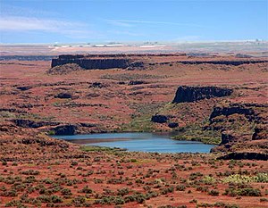
Drumheller Channels, 10 miles (16 km) south of Potholes Reservoir, are examples of channeled scablands

The Columbia Basin in Central Washington is fertile due to its loess soils, but large portions are a near desert, receiving less than ten inches (254 mm) of rain per year. The area is characterized by huge deposits of flood basalt, thousands of feet thick in places, laid down over a period of approximately 11 million years, during the Miocene epoch. These flood basalts are exposed in some places, while in others they are covered with thick layers of loess. 

During the last ice age glaciers shaped the landscape of the Columbia River Plateau. Ice blocked the Columbia River near the north end of Grand Coulee, creating glacial lakes Columbia and Spokane. Ice age glaciers also created Glacial Lake Missoula, in what is now Montana. Erosion allowed glacial Lake Columbia to begin to drain into what became Grand Coulee, which was fully created when glacial Lake Missoula along with glacial Lake Columbia catastrophically emptied. This flood event was one of several known as the Missoula Floods. Unique erosion features, called channeled scablands, are attributed to these amazing floods.

Component Units of the Project


Grand Coulee Dam Complex and Lake Roosevelt

  • Grand Coulee Dam (1950)
    • Right (north) Powerhouse
    • Left (south) Powerhouse
    • Third Powerhouse (1974) was added as a north wing of the dam from the original Right powerhouse. This addition expanded power generation by 300%.
  • Lake Roosevelt
  • Grand Coulee Pumping-Generating Plant (1953) consist of 12 pump-turbine units and two reversible pump-turbine units.) The reversible pump-turbines are used to move water from Lake Roosevelt into Banks Lake, from which it can be either sent south into the Columbia Basin Irrigation system or returned to Lake Roosevelt by the generating pumps to create additional electricity for the grid.

Feeder Canal, North and Dry Falls Dams, Banks Lake

Banks Lake (1951) is an artificial impoundment in the Upper Grand Coulee. It is 27 miles (43 km) long and 1 to 3 miles (1.6 to 4.8 km) wide. The coulee has nearly vertical rock walls up to 600 feet (180 m) high.

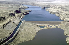
North Dam on Banks Lake with Feeder Canal
  • North Dam, near the town of Grand Coulee, has a maximum height of 145 feet (44 m) and a crest length of 1,400 feet (430 m).
  • Dry Falls, or South Dam, near Coulee City, has a maximum height of 123 feet (37 m) and a crest length of 8,880 feet (2,710 m). The crest elevation of both dams is 1,580 feet (480 m). Project water enters Banks Lake through the Feeder Canal from the Pump-generating plant. The outlet for Banks Lake is the Main Canal near Coulee City. It is near the east abutment of Dry Falls Dam. Banks Lake serves as an equalizing reservoir for storage of water for irrigation and can be used to for power generation.

Feeder Canal (1951) links North Dam at northern end of Banks Lake with the siphon outlets for the Grand Coulee Pumping—Generating plants discharge lines. It is 1.6 miles (2.6 km) long running in an open concrete-lined canal, and a twin-barrel concrete cut—and-cover conduit.[6] Main Canal (1951) is 8.3 miles (13.4 km), including 2.4 miles (3.9 km) of lake sections.[6] Bacon Tunnel and Siphon (1950) is a 1,037.5 feet (316.2 m) long sealed Siphon under the eastern extension of the Dry Falls draw.


  • Aerial view of Pinto Dam, Washington, USA.
  • Billy Clapp Lake (Pinto Dam – zoned earth & rockfill) (1951) aka (Long Lake Dam) is at the south end of Long Lake Coulee. The reservoir is 6 miles (9.7 km) long and 0.5 miles (0.80 km) wide.
  • Potholes Reservoir
 

Irrigation of the Columbia Basin

When it was built, Grand Coulee Dam was the largest dam in the world, but it was only part of the irrigation project. Additional dams were built at the north and south ends of Grand Coulee, the dry canyon south of Grand Coulee Dam, allowing the coulee to be filled with water pumped up from the Columbia River. The resulting reservoir, called Banks Lake, is about 30 miles (48 km) long. Banks Lake serves as the CBP's initial storage reservoir. Additional canals, siphons, and reservoirs were built south of Bank Lake, reaching over 100 miles (160 km). Water is lifted 280 feet (85 m) from Lake Roosevelt to feed the massive network.

The total amount of the Columbia flow that is diverted into the CBP at Grand Coulee varies a little from year to year, and is currently about 3.0 million acre-feet. This is about 3.8 percent of the Columbia's average flow as measured at the Grand Coulee dam. This amount is larger than the combined annual flows of the nearby Yakima, Wenatchee, and Okanagan rivers. There were plans to double the area of irrigated land, according to tour guides at the dam, over the next several decades. However, the Bureau of Reclamation website states that no further development is anticipated, with 671,000 acres (2,720 km2) irrigated out of the original 1,100,000 acres (4,500 km2) planned.

Interest in completing the Columbia Basin Project's 1,100,000 acres (4,500 km2) has grown in the late 20th and early 21st centuries. One reason for the renewed interest is the substantial depletion of the Odessa aquifer. Agricultural operations within the CBP's boundaries but outside the developed portion have for decades used groundwater pumped from the Odessa aquifer to irrigate crops.

Unintended consequences

Hydroelectricity was not the primary goal of the project, but during World War II the demand for electricity in the region boomed. The Hanford nuclear reservation was built just south of the project and aluminum smelting plants flocked to the Columbia Basin. A new power house was built at the Grand Coulee Dam, starting in the late sixties, that tripled the generating capacity. Part of the dam had to be blown up and re-built to make way for the new generators. Electricity is now transmitted to Canada and as far south as San Diego.

There are a number of issues regarding the runoff of irrigation water. The project region receives about 6 to 10 inches (250 mm) of annual rainfall, while the application of irrigation water amounts to an equivalent 40 to 50 inches (1,300 mm). The original plans did not sufficiently address the inevitable seepage and runoff. In some cases the results are beneficial. For example, numerous new lakes provide recreation opportunities and habitat for fish and game. In other cases agricultural chemicals in the runoff cause pollution.

Environmental impact

One environmental impact has been the reduction in native fish stocks above the dams. The majority of fish in the Columbia basin are migratory fish like salmon, sturgeon and steelhead. These migratory fish are often harmed or unable to pass through the narrow passages and turbines at dams. In addition to the physical barriers the dams pose, the slowing speed and altered course of the river raises temperatures, alters oxygen content, and changes river bed conditions. These altered conditions can stress and potentially kill both migratory and local non-migratory organisms in the river. The decimation of these migratory fish stocks above Grand Coulee Dam would not allow the former fishing lifestyle of Native Americans of the area, who once depended on the salmon for a way of life.

The environmental impacts of the Columbia Basin Project have made it a contentious and often politicized issue. A common argument for not implementing environmental safeguards at dam sites is that post-construction modifications would likely have to be significant. Tour guides at the Grand Coulee dam site, for example, indicate that a "fish ladder might have to be 5 miles (8.0 km) long to get the fish up the 550 feet (170 m) needed, and many fish would die before reaching the upper end" thus no fish ladders were built. Advocates of remedial measures point out that such steps would still be better than the status quo, which has led to marked die-offs and the likely extinction of several types of salmon.

The irrigation water provided by this project greatly benefits the agricultural production of the area. North Central Washington is one of the largest and most productive tree fruit producing areas on the planet. Without Coulee Dam and the greater Columbia Basin Project, much of North Central Washington State would be too arid for cultivation.

Economic benefits and costs

According to the federal Bureau of Reclamation the yearly value of the Columbia Basin Project is $630 million in irrigated crops, $950 million in power production, $20 million in flood damage prevention, and $50 million in recreation. The project itself involves costs that are difficult to determine. The farms that receive irrigation water must pay for it, but due to insufficient data from the Bureau of Reclamation it is not possible to compare the total cost paid by the Bureau to the payments received. Nevertheless, the farm payments account for only a small fraction of the total cost to the government, resulting in the project's agricultural corporations receiving a large water subsidy from the government. Critics describe the CBP as a classical example of federal money being used to subsidize a relatively small group of farmers in the American West in places where it would never be economically viable under other circumstances.

Tuesday, February 11, 2020

Grand Coulee

From Wikipedia, the free encyclopedia
https://en.wikipedia.org/wiki/Grand_Coulee
 
Grand Coulee
Grand coulee below dry falls.JPG
Grand Coulee, below Dry Falls. The layering effect of periodic basalt lava flows is visible.
Map showing the location of Grand Coulee
Map of Washington state
LocationWashington state
Coordinates47.62°N 119.3075°WCoordinates: 47.62°N 119.3075°W

Designated1965
Looking northward in the Grand Coulee.
 
Steamboat Rock in the Grand Coulee.
 
Part of the Grand Coulee has been dammed and filled with water as part of the Columbia Basin Project.
 
The Grand Coulee is an ancient river bed in the U.S. state of Washington. This National Natural Landmark stretches for about 60 miles (100 km) southwest from Grand Coulee Dam to Soap Lake, being bisected by Dry Falls into the Upper and Lower Grand Coulee.

Geological history

The Grand Coulee is part of the Columbia River Plateau. This area has underlying granite bedrock, formed deep in the Earth's crust 40 to 60 million years ago. The land periodically uplifted and subsided over millions of years giving rise to some small mountains and, eventually, an inland sea.

From about 10 to 18 million years ago, a series of volcanic eruptions from the Grand Ronde Rift near the Idaho/Oregon/Washington/Montana border began to fill the inland sea with lava. In some places the volcanic basalt is 6,600 feet (2.0 km) thick. In other areas granite from the earlier mountains is still exposed. 

Starting about two million years ago, during the Pleistocene epoch, glaciation took place in the area. Large parts of northern North America were repeatedly covered with glacial ice sheets, at times reaching over 10,000 feet (3,000 m) in thickness. Periodic climate changes resulted in corresponding advances and retreats of ice. 

About 18,000 years ago a large finger of ice advanced into present-day Idaho, forming an ice dam at what is now Lake Pend Oreille. It blocked the Clark Fork River drainage, thus creating an enormous lake reaching far back into mountain valleys of western Montana. As the lake deepened, the ice began to float. Leaks likely developed and enlarged, causing the dam to fail. The 500 cubic miles (2,100 km3) of water in Lake Missoula, were released in just 48 hours—a torrential flood equivalent to ten times the combined flow of all the rivers in the world.

This mass of water and ice, towering 2,000 feet (610 m) thick near the ice dam before release, flowed across the Columbia Basin, moving at speeds of up to 65 miles per hour (105 km/h). The deluge stripped away soil, cut deep canyons and carved out 50 cubic miles (210 km3) of earth, leaving behind areas of stark scabland. 

Over nearly 2500 years the cycle was repeated many times. Most of the displaced soil created new landforms, but some was carried far out into the Pacific Ocean. In Oregon's Willamette Valley, as far south as Eugene, the cataclysmic flood waters deposited fertile soil and icebergs left numerous boulders from as far away as Montana and Canada. At present day Portland, the water measured 400 feet (120 m) deep. A canyon 200 feet (61 m) deep is carved into the far edge of the continental shelf. The web-like formation can be seen from space. Mountains of gravel as tall as 40-story buildings were left behind; boulders the size of small houses and weighing many tons were strewn about the landscape. 

Grooves in the exposed granite bedrock are still visible in the area from the movement of glaciers, and numerous erratics are found in the elevated areas to the northwest of the coulee.

Early theories suggested that glaciers diverted the Columbia River into what became the Grand Coulee and that normal flows caused the erosion observed. In 1910 Joseph T. Pardee described a great Ice Age lake, "Glacial Lake Missoula", a glacier dammed lake with water up to 1,970 feet (600 m) deep, in northwest Montana and in 1940 he reported his discovery that giant dunes 50 feet (15 m) high and 200–500 feet (61–152 m) feet apart had formed the lake bed. In the 1920s J Harlen Bretz looked deeper into the landscape and put forth his theory of the dam breaches and massive glacial floods from Lake Missoula.

Of the Channeled Scablands, Dry Falls, one of the largest waterfalls ever known, is an excellent example (south of Banks Lake).

It is probable that humans were witnesses, and victims, of the immense power of the Ice Age Floods. Archeological records date human presence back to nearly the end of the Ice Age, but the raging torrents erased the land of clear evidence, leaving us to question who, if anyone, may have survived. With the end of the last glacial advance, the Columbia settled into its present course. The river bed is about 660 feet (200 m) below the Grand Coulee. Walls of the coulee reach 1,300 feet (400 m) in height. 

Upper Coulee

Grand Coulee is the longest and deepest of eastern Washington canyons. Its unique characteristics include a lower floor at the head of the channel than at its outlet and the widest and highest dry falls cliff in the middle. It was created through the process of cataract recession, which included a cataract twice as high as its existing Dry Falls.

Grand Coulee is two canyons, with an open basin in the middle. The Upper Coulee, filled by Banks Lake, is 25 miles (40 km) long with walls 800 to 900 feet (240 to 270 m) tall. It links to the Columbia River at Grand Coulee Dam and leads southward, through the surrounding highlands. The entry to the coulee is 650 feet (200 m) above the Columbia. It began as the course of a Glacial Columbia River. The Wisconsin ice sheets Okanogan lobe extended southward across the Columbia Rivers pathway and onto the southern plateau creating an ice dam. This dam backed up the waters of the Columbia into Glacial Lake Columbia and later during the Missoula Floods forced those waters into eastern Washington, creating the Scablands.

The river at Grand Coulee found no existing valley and thus forged its own pathway across the divide, creating the Upper Coulee. The plateau is not level, but is marked with wrinkles and upfolds of the basalt. The diverted waters of the Columbia, encountered the monoclinal flexure, a steep warping up of 1,000 feet (300 m) toward the northwest. Lake Columbia topped the ridge at the higher side of the flexure. Encountering the steep slope of the monocline, the new river would have cascaded off the rim, 800 feet (240 m) down onto a broad plain where Coulee City and Dry Falls State Park now stand.

Waterfall Erosion

Formation of Grand Coulee
 
Upper Grand Coulee began as an 800 feet (240 m) cascade just north of Coulee City. As the rush of water eroded the surface, it steepened into a waterfall. The falls continued to erode backward (northward) creating the canyon. When the falls reached the divide into Lake Columbia, i.e., preglacial Columbia Valley, it disappeared, leaving the elongated notch. Today, the waters of the Lake Roosevelt are pumped 280 feet (85 m) from the Grand Coulee Dam, into Banks Lake to act as an Equalizing Reservoir and irrigation water source.

Evidence of the waterfalls includes a plunge basin where the falls began, immediately south of Coulee City. It contains at least 300 feet (91 m) of gravel lower than the open flooring of the land. The river above the falls was shallow and much wider than the gorge. Thus, it wrapped around the lip of the main falls creating lateral falls. These flowed until the recession of the main falls denied them water. Northrup Canyon in Steamboat Rock State Park, contains a dry cataract as wide as Niagara Falls and three times as high.[7] Steamboat Rock 880 feet (270 m) high and a 1 square mile (2.6 km2) in area, now stands as an isolated rise, but for a time it created two cataracts. When the falls passed north of Steamboat Rock, it found a granite base beneath the basal flows. Granite lacks the close vertical joints of basalt, was resisted the erosion from the cataract's plunge. It remains as hills on the broad floor of the Coulee. Some gravel-bar deposits are visible along the Route 155. They provide evidence of eddies in the lee of rock shoulders. 

Lower Coulee

Dry Falls is at the head of Lower Grand Coulee. The Great Cataract forms the divide from the upper to lower coulees. The Lower Coulee tends along the monoclinal flexure to Soap Lake where the canyons end and the water flowed out into Quincy Basin. Quincy Basin is filled with the eroded gravels and silts from the Coulee. The Lower Coulee, also created its own path across the plains. Evidence of this is found in the tilted flows visible at Hogback islands in Lake Lenore and tilted flows along Washington 17 from Dry Falls to Park Lake. Numerous canyons acted as a distribution system for the volume of water flowing out of the upper coulee. The distribution begins in the uncanyoned basin below Dry Falls and expanded to over a 15 miles (24 km) before reaching Quincy Basin. One cataract (Unnamed Coulee) is 150 feet (46 m) high and had three alcoves over more than a 1 mile (1.6 km). There is no channel as the water arrived in a broad sheet. The gravel deposits of Quincy Basin represent only a third or a fourth of the estimated 11 cubic miles of rock excavated from the Grand Coulee and its smaller other related coulees (Dry, Long Lake, Jasper, Lenore, and Unnamed). Most of the debris was carried on through and beyond Quincy Basin

The Ephrata Fan is a gravel fan formed when floodwaters from the lower Grand Coulee entered the Quincy Basin during the formation of the Scablands.

Modern uses

The area surrounding the Grand Coulee is shrub-steppe habitat, with an average annual rainfall of less than twelve inches (300 mm). The Lower Grand Coulee contains Park, Blue, Alkali, Lenore, and Soap lakes. Until recently, the Upper Coulee was dry.

The Columbia Basin Project changed this in 1952, using the ancient river bed as an irrigation distribution network. The Upper Grand Coulee was dammed and turned into Banks Lake. The lake is filled by pumps from the Grand Coulee Dam and forms the first leg of a one-hundred-mile (160 km) irrigation system. Canals, siphons, and more dams are used throughout the Columbia Basin, supplying over 600,000 acres (240,000 ha) of farm land.

Water has turned the Upper Coulee and surrounding region into a haven for wildlife, including bald eagles. Recreation is a side benefit and includes several lakes, mineral springs, hunting and fishing, and water sports of all kinds. Sun Lakes and Steamboat Rock state parks are both found in the Grand Coulee. However, the lake has also flooded a large area of natural habitat and native hunting grounds, displacing local Native Americans.

Channeled Scablands

From Wikipedia, the free encyclopedia
 
  Cordilleran Ice Sheet
  maximum extent of Glacial Lake Missoula (eastern) and Glacial Lake Columbia (western)
  areas swept by Missoula and Columbia floods
 
Map of the Channeled Scablands
 
Loess island remnant in the Scablands

The Channeled Scablands at one time were a relatively barren and soil-free region of interconnected relict and dry flood channels, coulees and cataracts eroded into Palouse loess and the typically flat-lying basalt flows that remain after cataclysmic floods within the southeastern part of the U.S. state of Washington. The channeled scablands were scoured by more than 40 cataclysmic floods during the Last Glacial Maximum and innumerable older cataclysmic floods over the last two million years. These cataclysmic floods were repeatedly unleashed when a large glacial lake repeatedly drained and swept across eastern Washington and down the Columbia River Plateau during the Pleistocene epoch. The last of the cataclysmic floods occurred between 18,200 and 14,000 years ago.

Geologist J Harlen Bretz defined "scablands" in a series of papers written in the 1920s as lowlands diversified by a multiplicity of irregular channels and rock basins eroded into basalt. Flood waters eroded the loess cover, creating large anastomizing channels that exposed bare basalt and creating butte-and-basin topography. The buttes range in height from 30 to 100 m, while the rock basins range from 10 m in width up to the 11 km long and 30 m deep Rock Lake. Bretz further stated, "The channels run uphill and downhill, they unite and they divide, they head on the back-slopes and cut through the summit; they could not be more erratically and impossibly designed."

The debate on the origin of the Scablands that ensued for four decades became one of the great controversies in the history of earth science. The Scablands are also important to planetary scientists as perhaps the best terrestrial analog of the Martian outflow channels.

History

Bretz conducted research and published many papers during the 1920s describing the Channeled Scablands. His theories of how they were formed required short but immense floods – 500 cubic miles (2,100 km3) – for which Bretz had no explanation. Bretz's theories met with vehement opposition from geologists of the day, who tried to explain the features with uniformitarian theories.

J.T. Pardee first suggested in 1925 to Bretz that the draining of a glacial lake could account for flows of the magnitude needed. Pardee continued his research over the next 30 years, collecting and analyzing evidence that eventually identified Lake Missoula as the source of the Missoula Floods and creator of the Channeled Scablands.

Pardee's and Bretz's theories were accepted only after decades of painstaking work and fierce scientific debate. Research on open-channel hydraulics in the 1970s put Bretz's theories on solid scientific ground. In 1979 Bretz received the highest medal of the Geological Society of America, the Penrose Medal, to recognize that he had developed one of the great ideas in the earth sciences. 

Geology

Distinct geomorphological features include coulees, dry falls, streamlined hills and islands of remnant loess, gravel fans and bars, and giant current ripples.

The term scabland refers to an area that has experienced fluvial erosion resulting in the loss of loess and other soils, leaving the land barren. River valleys formed by erosional downcutting of rivers create V-shaped valleys, while glaciers carve out U-shaped valleys. The Channeled Scablands have a rectangular cross section, with flat plateaus and steep canyon sides, and are spread over immense areas of eastern Washington. The morphology of the scablands is butte-and-basin. The area that encompasses the Scablands has been estimated between 1,500 and 2,000 square miles (3,900 and 5,200 km2), though those estimates still may be too conservative.

They exhibit a unique drainage pattern that appears to have an entrance in the northeast and an exit in the southwest. The Cordilleran Ice Sheet dammed up Glacial Lake Missoula at the Purcell Trench Lobe. A series of floods occurring over the period of 18,000 to 13,000 years ago swept over the landscape when the ice dam broke. The eroded channels also show an anastomosing, or braided, appearance.

The presence of Middle and Early Pleistocene Missoula flood deposits have been documented within the Channeled Scabland as other parts of the Columbia Basin, e.g. the Othello Channels, Columbia River Gorge, Quincy Basin, Pasco Basin, and the Walla Walla Valley. Based on the presence of multiple interglacial calcretes interbedded with glaciofluvial flood deposits, magnetostratigraphy, optically stimulated luminescence dating, and unconformity truncated clastic dikes, it has been estimated that the oldest of these megafloods flowed through the Channel Scablands sometime before 1.5 million years ago. Because of the fragmentary nature of older glaciofluvial deposits, which have been largely removed by subsequent Missoula floods, the exact number of older Missoula floods, which are known as Ancient Cataclysmic Floods, that occurred during the Pleistocene cannot be estimated with any confidence. As many as 100 separate, cataclysmic Ice Age floods may have occurred during the last glaciation. There have been at least 17 complete interglacial-glacial cycles since about 1.77 million years ago, and perhaps as many as 44 interglacial-glacial cycles since the beginning of the Pleistocene about 2.58 million years ago. Presuming a dozen (or more) floods were associated with each glaciation, the total number of cataclysmic Ice Age Missoula floods that flowed through the Channeled Scablands for the entire Pleistocene Epoch could possibly number in the hundreds, perhaps exceeding a thousand Ancient Cataclysmic Floods.

There are also immense potholes and ripple marks, much larger than those found on ordinary rivers. When these features were first studied, no known theories could explain their origin. The giant current ripples are between 3 and 49 feet (1 and 15 m) high and are regularly spaced, relatively uniform hills. Vast volumes of flowing water would be required to produce ripple marks of this magnitude, as they are larger-scale versions of the ripple marks found on streambeds that are typically only centimeters high. Large potholes were formed by swirling vortexes of water called kolks scouring and plucking out the bedrock.

The Scablands are littered with large boulders called glacial erratics that rafted on glaciers and were deposited by the glacial outburst flooding. The lithology of erratics usually does not match the rock type that surrounds it, as they are often carried very far from their origin.

Inequality (mathematics)

From Wikipedia, the free encyclopedia https://en.wikipedia.org/wiki/Inequality...