Search This Blog

Sunday, October 17, 2021

Earth's magnetic field

From Wikipedia, the free encyclopedia
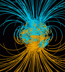
Computer simulation of the Earth's field in a period of normal polarity between reversals. The lines represent magnetic field lines, blue when the field points towards the center and yellow when away. The rotation axis of the Earth is centered and vertical. The dense clusters of lines are within the Earth's core.

Earth's magnetic field, also known as the geomagnetic field, is the magnetic field that extends from the Earth's interior out into space, where it interacts with the solar wind, a stream of charged particles emanating from the Sun. The magnetic field is generated by electric currents due to the motion of convection currents of a mixture of molten iron and nickel in the Earth's outer core: these convection currents are caused by heat escaping from the core, a natural process called a geodynamo. The magnitude of the Earth's magnetic field at its surface ranges from 25 to 65 μT (0.25 to 0.65 gauss). As an approximation, it is represented by a field of a magnetic dipole currently tilted at an angle of about 11 degrees with respect to Earth's rotational axis, as if there were an enormous bar magnet placed at that angle through the center of the Earth. The North geomagnetic pole actually represents the South pole of the Earth's magnetic field, and conversely the South geomagnetic pole corresponds to the north pole of Earth's magnetic field (because opposite magnetic poles attract and the north end of a magnet, like a compass needle, points toward the Earth's South magnetic field, i.e., the North geomagnetic pole near the Geographic North Pole). As of 2015, the North geomagnetic pole was located on Ellesmere Island, Nunavut, Canada.

While the North and South magnetic poles are usually located near the geographic poles, they slowly and continuously move over geological time scales, but sufficiently slowly for ordinary compasses to remain useful for navigation. However, at irregular intervals averaging several hundred thousand years, the Earth's field reverses and the North and South Magnetic Poles respectively, abruptly switch places. These reversals of the geomagnetic poles leave a record in rocks that are of value to paleomagnetists in calculating geomagnetic fields in the past. Such information in turn is helpful in studying the motions of continents and ocean floors in the process of plate tectonics.

The magnetosphere is the region above the ionosphere that is defined by the extent of the Earth's magnetic field in space. It extends several tens of thousands of kilometres into space, protecting the Earth from the charged particles of the solar wind and cosmic rays that would otherwise strip away the upper atmosphere, including the ozone layer that protects the Earth from the harmful ultraviolet radiation.

Significance

Earth's magnetic field deflects most of the solar wind, whose charged particles would otherwise strip away the ozone layer that protects the Earth from harmful ultraviolet radiation. One stripping mechanism is for gas to be caught in bubbles of magnetic field, which are ripped off by solar winds. Calculations of the loss of carbon dioxide from the atmosphere of Mars, resulting from scavenging of ions by the solar wind, indicate that the dissipation of the magnetic field of Mars caused a near total loss of its atmosphere.

The study of the past magnetic field of the Earth is known as paleomagnetism. The polarity of the Earth's magnetic field is recorded in igneous rocks, and reversals of the field are thus detectable as "stripes" centered on mid-ocean ridges where the sea floor is spreading, while the stability of the geomagnetic poles between reversals has allowed paleomagnetism to track the past motion of continents. Reversals also provide the basis for magnetostratigraphy, a way of dating rocks and sediments. The field also magnetizes the crust, and magnetic anomalies can be used to search for deposits of metal ores.

Humans have used compasses for direction finding since the 11th century A.D. and for navigation since the 12th century. Although the magnetic declination does shift with time, this wandering is slow enough that a simple compass can remain useful for navigation. Using magnetoreception, various other organisms, ranging from some types of bacteria to pigeons, use the Earth's magnetic field for orientation and navigation.

Characteristics

At any location, the Earth's magnetic field can be represented by a three-dimensional vector. A typical procedure for measuring its direction is to use a compass to determine the direction of magnetic North. Its angle relative to true North is the declination (D) or variation. Facing magnetic North, the angle the field makes with the horizontal is the inclination (I) or magnetic dip. The intensity (F) of the field is proportional to the force it exerts on a magnet. Another common representation is in X (North), Y (East) and Z (Down) coordinates.


Common coordinate systems used for representing the Earth's magnetic field.

Intensity

The intensity of the field is often measured in gauss (G), but is generally reported in nanoteslas (nT), with 1 G = 100,000 nT. A nanotesla is also referred to as a gamma (γ). The Earth's field ranges between approximately 25,000 and 65,000 nT (0.25–0.65 G). By comparison, a strong refrigerator magnet has a field of about 10,000,000 nanoteslas (100 G).

A map of intensity contours is called an isodynamic chart. As the World Magnetic Model shows, the intensity tends to decrease from the poles to the equator. A minimum intensity occurs in the South Atlantic Anomaly over South America while there are maxima over northern Canada, Siberia, and the coast of Antarctica south of Australia.

The intensity of the magnetic field is subject to change over time. A 2021 paleomagnetic study from the University of Liverpool contributed to a growing body of evidence that the Earth's magnetic field cycles with intensity every 200 million years. The lead author stated that “Our findings, when considered alongside the existing datasets, support the existence of an approximately 200-million-year-long cycle in the strength of the Earth’s magnetic field related to deep Earth processes.”

Inclination

The inclination is given by an angle that can assume values between -90° (up) to 90° (down). In the northern hemisphere, the field points downwards. It is straight down at the North Magnetic Pole and rotates upwards as the latitude decreases until it is horizontal (0°) at the magnetic equator. It continues to rotate upwards until it is straight up at the South Magnetic Pole. Inclination can be measured with a dip circle.

An isoclinic chart (map of inclination contours) for the Earth's magnetic field is shown below.

Declination

Declination is positive for an eastward deviation of the field relative to true north. It can be estimated by comparing the magnetic north–south heading on a compass with the direction of a celestial pole. Maps typically include information on the declination as an angle or a small diagram showing the relationship between magnetic north and true north. Information on declination for a region can be represented by a chart with isogonic lines (contour lines with each line representing a fixed declination).

Geographical variation

Components of the Earth's magnetic field at the surface from the World Magnetic Model for 2015.

Dipolar approximation

Relationship between Earth's poles. A1 and A2 are the geographic poles; B1 and B2 are the geomagnetic poles; C1 (south) and C2 (north) are the magnetic poles.
 

Near the surface of the Earth, its magnetic field can be closely approximated by the field of a magnetic dipole positioned at the center of the Earth and tilted at an angle of about 11° with respect to the rotational axis of the Earth. The dipole is roughly equivalent to a powerful bar magnet, with its south pole pointing towards the geomagnetic North Pole. This may seem surprising, but the north pole of a magnet is so defined because, if allowed to rotate freely, it points roughly northward (in the geographic sense). Since the north pole of a magnet attracts the south poles of other magnets and repels the north poles, it must be attracted to the south pole of Earth's magnet. The dipolar field accounts for 80–90% of the field in most locations.

Magnetic poles

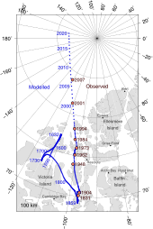
The movement of Earth's North Magnetic Pole across the Canadian arctic.

Historically, the north and south poles of a magnet were first defined by the Earth's magnetic field, not vice versa, since one of the first uses for a magnet was as a compass needle. A magnet's North pole is defined as the pole that is attracted by the Earth's North Magnetic Pole when the magnet is suspended so it can turn freely. Since opposite poles attract, the North Magnetic Pole of the Earth is really the south pole of its magnetic field (the place where the field is directed downward into the Earth).

The positions of the magnetic poles can be defined in at least two ways: locally or globally. The local definition is the point where the magnetic field is vertical. This can be determined by measuring the inclination. The inclination of the Earth's field is 90° (downwards) at the North Magnetic Pole and -90° (upwards) at the South Magnetic Pole. The two poles wander independently of each other and are not directly opposite each other on the globe. Movements of up to 40 kilometres (25 mi) per year have been observed for the North Magnetic Pole. Over the last 180 years, the North Magnetic Pole has been migrating northwestward, from Cape Adelaide in the Boothia Peninsula in 1831 to 600 kilometres (370 mi) from Resolute Bay in 2001. The magnetic equator is the line where the inclination is zero (the magnetic field is horizontal).

The global definition of the Earth's field is based on a mathematical model. If a line is drawn through the center of the Earth, parallel to the moment of the best-fitting magnetic dipole, the two positions where it intersects the Earth's surface are called the North and South geomagnetic poles. If the Earth's magnetic field were perfectly dipolar, the geomagnetic poles and magnetic dip poles would coincide and compasses would point towards them. However, the Earth's field has a significant non-dipolar contribution, so the poles do not coincide and compasses do not generally point at either.

Magnetosphere

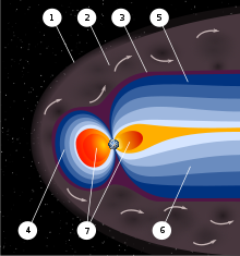
An artist's rendering of the structure of a magnetosphere. 1) Bow shock. 2) Magnetosheath. 3) Magnetopause. 4) Magnetosphere. 5) Northern tail lobe. 6) Southern tail lobe. 7) Plasmasphere.

Earth's magnetic field, predominantly dipolar at its surface, is distorted further out by the solar wind. This is a stream of charged particles leaving the Sun's corona and accelerating to a speed of 200 to 1000 kilometres per second. They carry with them a magnetic field, the interplanetary magnetic field (IMF).

The solar wind exerts a pressure, and if it could reach Earth's atmosphere it would erode it. However, it is kept away by the pressure of the Earth's magnetic field. The magnetopause, the area where the pressures balance, is the boundary of the magnetosphere. Despite its name, the magnetosphere is asymmetric, with the sunward side being about 10 Earth radii out but the other side stretching out in a magnetotail that extends beyond 200 Earth radii. Sunward of the magnetopause is the bow shock, the area where the solar wind slows abruptly.

Inside the magnetosphere is the plasmasphere, a donut-shaped region containing low-energy charged particles, or plasma. This region begins at a height of 60 km, extends up to 3 or 4 Earth radii, and includes the ionosphere. This region rotates with the Earth. There are also two concentric tire-shaped regions, called the Van Allen radiation belts, with high-energy ions (energies from 0.1 to 10 million electron volts (MeV)). The inner belt is 1–2 Earth radii out while the outer belt is at 4–7 Earth radii. The plasmasphere and Van Allen belts have partial overlap, with the extent of overlap varying greatly with solar activity.

As well as deflecting the solar wind, the Earth's magnetic field deflects cosmic rays, high-energy charged particles that are mostly from outside the Solar System. Many cosmic rays are kept out of the Solar System by the Sun's magnetosphere, or heliosphere. By contrast, astronauts on the Moon risk exposure to radiation. Anyone who had been on the Moon's surface during a particularly violent solar eruption in 2005 would have received a lethal dose.

Some of the charged particles do get into the magnetosphere. These spiral around field lines, bouncing back and forth between the poles several times per second. In addition, positive ions slowly drift westward and negative ions drift eastward, giving rise to a ring current. This current reduces the magnetic field at the Earth's surface. Particles that penetrate the ionosphere and collide with the atoms there give rise to the lights of the aurorae and also emit X-rays.

The varying conditions in the magnetosphere, known as space weather, are largely driven by solar activity. If the solar wind is weak, the magnetosphere expands; while if it is strong, it compresses the magnetosphere and more of it gets in. Periods of particularly intense activity, called geomagnetic storms, can occur when a coronal mass ejection erupts above the Sun and sends a shock wave through the Solar System. Such a wave can take just two days to reach the Earth. Geomagnetic storms can cause a lot of disruption; the "Halloween" storm of 2003 damaged more than a third of NASA's satellites. The largest documented storm occurred in 1859. It induced currents strong enough to short out telegraph lines, and aurorae were reported as far south as Hawaii.

Time dependence

Short-term variations

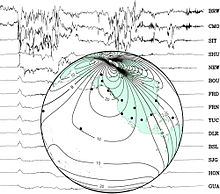
Background: a set of traces from magnetic observatories showing a magnetic storm in 2000.
Globe: map showing locations of observatories and contour lines giving horizontal magnetic intensity in μ T.

The geomagnetic field changes on time scales from milliseconds to millions of years. Shorter time scales mostly arise from currents in the ionosphere (ionospheric dynamo region) and magnetosphere, and some changes can be traced to geomagnetic storms or daily variations in currents. Changes over time scales of a year or more mostly reflect changes in the Earth's interior, particularly the iron-rich core.

Frequently, the Earth's magnetosphere is hit by solar flares causing geomagnetic storms, provoking displays of aurorae. The short-term instability of the magnetic field is measured with the K-index.

Data from THEMIS show that the magnetic field, which interacts with the solar wind, is reduced when the magnetic orientation is aligned between Sun and Earth – opposite to the previous hypothesis. During forthcoming solar storms, this could result in blackouts and disruptions in artificial satellites.

Secular variation

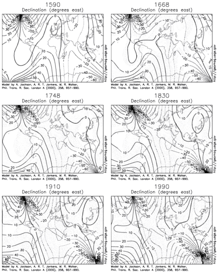
Estimated declination contours by year, 1590 to 1990 (click to see variation).
 
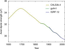
Strength of the axial dipole component of Earth's magnetic field from 1600 to 2020.

Changes in Earth's magnetic field on a time scale of a year or more are referred to as secular variation. Over hundreds of years, magnetic declination is observed to vary over tens of degrees. The animation shows how global declinations have changed over the last few centuries.

The direction and intensity of the dipole change over time. Over the last two centuries the dipole strength has been decreasing at a rate of about 6.3% per century. At this rate of decrease, the field would be negligible in about 1600 years. However, this strength is about average for the last 7 thousand years, and the current rate of change is not unusual.

A prominent feature in the non-dipolar part of the secular variation is a westward drift at a rate of about 0.2 degrees per year. This drift is not the same everywhere and has varied over time. The globally averaged drift has been westward since about 1400 AD but eastward between about 1000 AD and 1400 AD.

Changes that predate magnetic observatories are recorded in archaeological and geological materials. Such changes are referred to as paleomagnetic secular variation or paleosecular variation (PSV). The records typically include long periods of small change with occasional large changes reflecting geomagnetic excursions and reversals.

In July 2020 scientists report that analysis of simulations and a recent observational field model show that maximum rates of directional change of Earth's magnetic field reached ~10° per year – almost 100 times faster than current changes and 10 times faster than previously thought.

Studies of lava flows on Steens Mountain, Oregon, indicate that the magnetic field could have shifted at a rate of up to 6 degrees per day at some time in Earth's history, which significantly challenges the popular understanding of how the Earth's magnetic field works. This finding was later attributed to unusual rock magnetic properties of the lava flow under study, not rapid field change, by one of the original authors of the 1995 study.

Magnetic field reversals

Geomagnetic polarity during the late Cenozoic Era. Dark areas denote periods where the polarity matches today's polarity, light areas denote periods where that polarity is reversed.
 

Although generally Earth's field is approximately dipolar, with an axis that is nearly aligned with the rotational axis, occasionally the North and South geomagnetic poles trade places. Evidence for these geomagnetic reversals can be found in basalts, sediment cores taken from the ocean floors, and seafloor magnetic anomalies. Reversals occur nearly randomly in time, with intervals between reversals ranging from less than 0.1 million years to as much as 50 million years. The most recent geomagnetic reversal, called the Brunhes–Matuyama reversal, occurred about 780,000 years ago. A related phenomenon, a geomagnetic excursion, takes the dipole axis across the equator and then back to the original polarity. The Laschamp event is an example of an excursion, occurring during the last ice age (41,000 years ago).

The past magnetic field is recorded mostly by strongly magnetic minerals, particularly iron oxides such as magnetite, that can carry a permanent magnetic moment. This remanent magnetization, or remanence, can be acquired in more than one way. In lava flows, the direction of the field is "frozen" in small minerals as they cool, giving rise to a thermoremanent magnetization. In sediments, the orientation of magnetic particles acquires a slight bias towards the magnetic field as they are deposited on an ocean floor or lake bottom. This is called detrital remanent magnetization.

Thermoremanent magnetization is the main source of the magnetic anomalies around mid-ocean ridges. As the seafloor spreads, magma wells up from the mantle, cools to form new basaltic crust on both sides of the ridge, and is carried away from it by seafloor spreading. As it cools, it records the direction of the Earth's field. When the Earth's field reverses, new basalt records the reversed direction. The result is a series of stripes that are symmetric about the ridge. A ship towing a magnetometer on the surface of the ocean can detect these stripes and infer the age of the ocean floor below. This provides information on the rate at which seafloor has spread in the past.

Radiometric dating of lava flows has been used to establish a geomagnetic polarity time scale, part of which is shown in the image. This forms the basis of magnetostratigraphy, a geophysical correlation technique that can be used to date both sedimentary and volcanic sequences as well as the seafloor magnetic anomalies.

Earliest appearance

Paleomagnetic studies of Paleoarchean lava in Australia and conglomerate in South Africa have concluded that the magnetic field has been present since at least about 3,450 million years ago.

Future

Variations in virtual axial dipole moment since the last reversal.

At present, the overall geomagnetic field is becoming weaker; the present strong deterioration corresponds to a 10–15% decline over the last 150 years and has accelerated in the past several years; geomagnetic intensity has declined almost continuously from a maximum 35% above the modern value achieved approximately 2,000 years ago. The rate of decrease and the current strength are within the normal range of variation, as shown by the record of past magnetic fields recorded in rocks.

The nature of Earth's magnetic field is one of heteroscedastic fluctuation. An instantaneous measurement of it, or several measurements of it across the span of decades or centuries, are not sufficient to extrapolate an overall trend in the field strength. It has gone up and down in the past for unknown reasons. Also, noting the local intensity of the dipole field (or its fluctuation) is insufficient to characterize Earth's magnetic field as a whole, as it is not strictly a dipole field. The dipole component of Earth's field can diminish even while the total magnetic field remains the same or increases.

The Earth's magnetic north pole is drifting from northern Canada towards Siberia with a presently accelerating rate—10 kilometres (6.2 mi) per year at the beginning of the 20th century, up to 40 kilometres (25 mi) per year in 2003, and since then has only accelerated.

Physical origin

Earth's core and the geodynamo

The Earth's magnetic field is believed to be generated by electric currents in the conductive iron alloys of its core, created by convection currents due to heat escaping from the core. However the process is complex, and computer models that reproduce some of its features have only been developed in the last few decades.

A schematic illustrating the relationship between motion of conducting fluid, organized into rolls by the Coriolis force, and the magnetic field the motion generates.

The Earth and most of the planets in the Solar System, as well as the Sun and other stars, all generate magnetic fields through the motion of electrically conducting fluids. The Earth's field originates in its core. This is a region of iron alloys extending to about 3400 km (the radius of the Earth is 6370 km). It is divided into a solid inner core, with a radius of 1220 km, and a liquid outer core. The motion of the liquid in the outer core is driven by heat flow from the inner core, which is about 6,000 K (5,730 °C; 10,340 °F), to the core-mantle boundary, which is about 3,800 K (3,530 °C; 6,380 °F). The heat is generated by potential energy released by heavier materials sinking toward the core (planetary differentiation, the iron catastrophe) as well as decay of radioactive elements in the interior. The pattern of flow is organized by the rotation of the Earth and the presence of the solid inner core.

The mechanism by which the Earth generates a magnetic field is known as a dynamo. The magnetic field is generated by a feedback loop: current loops generate magnetic fields (Ampère's circuital law); a changing magnetic field generates an electric field (Faraday's law); and the electric and magnetic fields exert a force on the charges that are flowing in currents (the Lorentz force). These effects can be combined in a partial differential equation for the magnetic field called the magnetic induction equation,

where u is the velocity of the fluid; B is the magnetic B-field; and η=1/σμ is the magnetic diffusivity, which is inversely proportional to the product of the electrical conductivity σ and the permeability μ . The term B/∂t is the time derivative of the field; 2 is the Laplace operator and ∇× is the curl operator.

The first term on the right hand side of the induction equation is a diffusion term. In a stationary fluid, the magnetic field declines and any concentrations of field spread out. If the Earth's dynamo shut off, the dipole part would disappear in a few tens of thousands of years.

In a perfect conductor (), there would be no diffusion. By Lenz's law, any change in the magnetic field would be immediately opposed by currents, so the flux through a given volume of fluid could not change. As the fluid moved, the magnetic field would go with it. The theorem describing this effect is called the frozen-in-field theorem. Even in a fluid with a finite conductivity, new field is generated by stretching field lines as the fluid moves in ways that deform it. This process could go on generating new field indefinitely, were it not that as the magnetic field increases in strength, it resists fluid motion.

The motion of the fluid is sustained by convection, motion driven by buoyancy. The temperature increases towards the center of the Earth, and the higher temperature of the fluid lower down makes it buoyant. This buoyancy is enhanced by chemical separation: As the core cools, some of the molten iron solidifies and is plated to the inner core. In the process, lighter elements are left behind in the fluid, making it lighter. This is called compositional convection. A Coriolis effect, caused by the overall planetary rotation, tends to organize the flow into rolls aligned along the north–south polar axis.

A dynamo can amplify a magnetic field, but it needs a "seed" field to get it started. For the Earth, this could have been an external magnetic field. Early in its history the Sun went through a T-Tauri phase in which the solar wind would have had a magnetic field orders of magnitude larger than the present solar wind. However, much of the field may have been screened out by the Earth's mantle. An alternative source is currents in the core-mantle boundary driven by chemical reactions or variations in thermal or electric conductivity. Such effects may still provide a small bias that are part of the boundary conditions for the geodynamo.

The average magnetic field in the Earth's outer core was calculated to be 25 gauss, 50 times stronger than the field at the surface.

Numerical models

Simulating the geodynamo by computer requires numerically solving a set of nonlinear partial differential equations for the magnetohydrodynamics (MHD) of the Earth's interior. Simulation of the MHD equations is performed on a 3D grid of points and the fineness of the grid, which in part determines the realism of the solutions, is limited mainly by computer power. For decades, theorists were confined to creating kinematic dynamo computer models in which the fluid motion is chosen in advance and the effect on the magnetic field calculated. Kinematic dynamo theory was mainly a matter of trying different flow geometries and testing whether such geometries could sustain a dynamo.

The first self-consistent dynamo models, ones that determine both the fluid motions and the magnetic field, were developed by two groups in 1995, one in Japan and one in the United States. The latter received attention because it successfully reproduced some of the characteristics of the Earth's field, including geomagnetic reversals.

Currents in the ionosphere and magnetosphere

Electric currents induced in the ionosphere generate magnetic fields (ionospheric dynamo region). Such a field is always generated near where the atmosphere is closest to the Sun, causing daily alterations that can deflect surface magnetic fields by as much as one degree. Typical daily variations of field strength are about 25 nanoteslas (nT) (one part in 2000), with variations over a few seconds of typically around 1 nT (one part in 50,000).

Measurement and analysis

Detection

The Earth's magnetic field strength was measured by Carl Friedrich Gauss in 1832 and has been repeatedly measured since then, showing a relative decay of about 10% over the last 150 years. The Magsat satellite and later satellites have used 3-axis vector magnetometers to probe the 3-D structure of the Earth's magnetic field. The later Ørsted satellite allowed a comparison indicating a dynamic geodynamo in action that appears to be giving rise to an alternate pole under the Atlantic Ocean west of South Africa.

Governments sometimes operate units that specialize in measurement of the Earth's magnetic field. These are geomagnetic observatories, typically part of a national Geological survey, for example, the British Geological Survey's Eskdalemuir Observatory. Such observatories can measure and forecast magnetic conditions such as magnetic storms that sometimes affect communications, electric power, and other human activities.

The International Real-time Magnetic Observatory Network, with over 100 interlinked geomagnetic observatories around the world, has been recording the Earth's magnetic field since 1991.

The military determines local geomagnetic field characteristics, in order to detect anomalies in the natural background that might be caused by a significant metallic object such as a submerged submarine. Typically, these magnetic anomaly detectors are flown in aircraft like the UK's Nimrod or towed as an instrument or an array of instruments from surface ships.

Commercially, geophysical prospecting companies also use magnetic detectors to identify naturally occurring anomalies from ore bodies, such as the Kursk Magnetic Anomaly.

Crustal magnetic anomalies

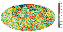
A model of short-wavelength features of Earth's magnetic field, attributed to lithospheric anomalies

Magnetometers detect minute deviations in the Earth's magnetic field caused by iron artifacts, kilns, some types of stone structures, and even ditches and middens in archaeological geophysics. Using magnetic instruments adapted from airborne magnetic anomaly detectors developed during World War II to detect submarines, the magnetic variations across the ocean floor have been mapped. Basalt — the iron-rich, volcanic rock making up the ocean floor — contains a strongly magnetic mineral (magnetite) and can locally distort compass readings. The distortion was recognized by Icelandic mariners as early as the late 18th century. More important, because the presence of magnetite gives the basalt measurable magnetic properties, these magnetic variations have provided another means to study the deep ocean floor. When newly formed rock cools, such magnetic materials record the Earth's magnetic field.

Statistical models

Each measurement of the magnetic field is at a particular place and time. If an accurate estimate of the field at some other place and time is needed, the measurements must be converted to a model and the model used to make predictions.

Spherical harmonics

Schematic representation of spherical harmonics on a sphere and their nodal lines. Pm is equal to 0 along m great circles passing through the poles, and along ℓ-m circles of equal latitude. The function changes sign each ℓtime it crosses one of these lines.
 
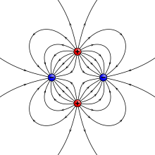
Example of a quadrupole field. This can also be constructed by moving two dipoles together.

The most common way of analyzing the global variations in the Earth's magnetic field is to fit the measurements to a set of spherical harmonics. This was first done by Carl Friedrich Gauss. Spherical harmonics are functions that oscillate over the surface of a sphere. They are the product of two functions, one that depends on latitude and one on longitude. The function of longitude is zero along zero or more great circles passing through the North and South Poles; the number of such nodal lines is the absolute value of the order m. The function of latitude is zero along zero or more latitude circles; this plus the order is equal to the degree ℓ. Each harmonic is equivalent to a particular arrangement of magnetic charges at the center of the Earth. A monopole is an isolated magnetic charge, which has never been observed. A dipole is equivalent to two opposing charges brought close together and a quadrupole to two dipoles brought together. A quadrupole field is shown in the lower figure on the right.

Spherical harmonics can represent any scalar field (function of position) that satisfies certain properties. A magnetic field is a vector field, but if it is expressed in Cartesian components X, Y, Z, each component is the derivative of the same scalar function called the magnetic potential. Analyses of the Earth's magnetic field use a modified version of the usual spherical harmonics that differ by a multiplicative factor. A least-squares fit to the magnetic field measurements gives the Earth's field as the sum of spherical harmonics, each multiplied by the best-fitting Gauss coefficient gm or hm.

The lowest-degree Gauss coefficient, g00, gives the contribution of an isolated magnetic charge, so it is zero. The next three coefficients – g10, g11, and h11 – determine the direction and magnitude of the dipole contribution. The best fitting dipole is tilted at an angle of about 10° with respect to the rotational axis, as described earlier.

Radial dependence

Spherical harmonic analysis can be used to distinguish internal from external sources if measurements are available at more than one height (for example, ground observatories and satellites). In that case, each term with coefficient gm or hm can be split into two terms: one that decreases with radius as 1/rℓ+1 and one that increases with radius as r. The increasing terms fit the external sources (currents in the ionosphere and magnetosphere). However, averaged over a few years the external contributions average to zero.

The remaining terms predict that the potential of a dipole source (ℓ=1) drops off as 1/r2. The magnetic field, being a derivative of the potential, drops off as 1/r3. Quadrupole terms drop off as 1/r4, and higher order terms drop off increasingly rapidly with the radius. The radius of the outer core is about half of the radius of the Earth. If the field at the core-mantle boundary is fit to spherical harmonics, the dipole part is smaller by a factor of about 8 at the surface, the quadrupole part by a factor of 16, and so on. Thus, only the components with large wavelengths can be noticeable at the surface. From a variety of arguments, it is usually assumed that only terms up to degree 14 or less have their origin in the core. These have wavelengths of about 2,000 kilometres (1,200 mi) or less. Smaller features are attributed to crustal anomalies.

Global models

The International Association of Geomagnetism and Aeronomy maintains a standard global field model called the International Geomagnetic Reference Field. It is updated every five years. The 11th-generation model, IGRF11, was developed using data from satellites (Ørsted, CHAMP and SAC-C) and a world network of geomagnetic observatories. The spherical harmonic expansion was truncated at degree 10, with 120 coefficients, until 2000. Subsequent models are truncated at degree 13 (195 coefficients).

Another global field model, called the World Magnetic Model, is produced jointly by the United States National Centers for Environmental Information (formerly the National Geophysical Data Center) and the British Geological Survey. This model truncates at degree 12 (168 coefficients) with an approximate spatial resolution of 3,000 kilometers. It is the model used by the United States Department of Defense, the Ministry of Defence (United Kingdom), the United States Federal Aviation Administration (FAA), the North Atlantic Treaty Organization (NATO), and the International Hydrographic Organization as well as in many civilian navigation systems.

A third model, produced by the Goddard Space Flight Center (NASA and GSFC) and the Danish Space Research Institute, uses a "comprehensive modeling" approach that attempts to reconcile data with greatly varying temporal and spatial resolution from ground and satellite sources.

For users with higher accuracy needs, the United States National Centers for Environmental Information developed the Enhanced Magnetic Model (EMM), which extends to degree and order 790 and resolves magnetic anomalies down to a wavelength of 56 kilometers. It was compiled from satellite, marine, aeromagnetic and ground magnetic surveys. As of 2018, the latest version, EMM2017, includes data from The European Space Agency's Swarm satellite mission.

Effect of ocean tides

The oceans contribute to Earth's magnetic field. Seawater is an electrical conductor, and therefore interacts with the magnetic field. As the tides cycle around the ocean basins, the ocean water essentially tries to pull the geomagnetic field lines along. Because the salty water is slightly conductive, the interaction is relatively weak: the strongest component is from the regular lunar tide that happens about twice per day. Other contributions come from ocean swell, eddies, and even tsunamis.

Sea level magnetic fields observed by satellites (NASA) 

The strength of the interaction depends also on the temperature of the ocean water. The entire heat stored in the ocean can now be inferred from observations of the Earth's magnetic field.

Biomagnetism

Animals, including birds and turtles, can detect the Earth's magnetic field, and use the field to navigate during migration. Some researchers have found that cows and wild deer tend to align their bodies north–south while relaxing, but not when the animals are under high-voltage power lines, suggesting that magnetism is responsible. Other researchers reported in 2011 that they could not replicate those findings using different Google Earth images.

Very weak electromagnetic fields disrupt the magnetic compass used by European robins and other songbirds, which use the Earth's magnetic field to navigate. Neither power lines nor cellphone signals are to blame for the electromagnetic field effect on the birds; instead, the culprits have frequencies between 2 kHz and 5 MHz. These include AM radio signals and ordinary electronic equipment that might be found in businesses or private homes.
Atmospheric electricity

From Wikipedia, the free encyclopedia
 
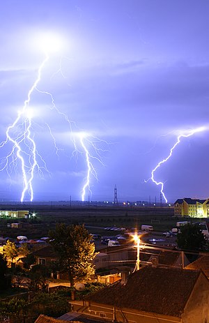
Cloud to ground lightning. Typically, lightning discharges 30,000 amperes, at up to 100 million volts, and emits light, radio waves, x-rays and even gamma rays. Plasma temperatures in lightning can approach 28,000 kelvins.

Atmospheric electricity is the study of electrical charges in the Earth's atmosphere (or that of another planet). The movement of charge between the Earth's surface, the atmosphere, and the ionosphere is known as the global atmospheric electrical circuit. Atmospheric electricity is an interdisciplinary topic with a long history, involving concepts from electrostatics, atmospheric physics, meteorology and Earth science.

Thunderstorms act as a giant battery in the atmosphere, charging up the electrosphere to about 400,000 volts with respect to the surface. This sets up an electric field throughout the atmosphere, which decreases with increase in altitude. Atmospheric ions created by cosmic rays and natural radioactivity move in the electric field, so a very small current flows through the atmosphere, even away from thunderstorms. Near the surface of the earth, the magnitude of the field is on average around 100 V/m.

Atmospheric electricity involves both thunderstorms, which create lightning bolts to rapidly discharge huge amounts of atmospheric charge stored in storm clouds, and the continual electrification of the air due to ionization from cosmic rays and natural radioactivity, which ensure that the atmosphere is never quite neutral.

History

Sparks drawn from electrical machines and from Leyden jars suggested to the early experimenters, Hauksbee, Newton, Wall, Nollet, and Gray, that lightning was caused by electric discharges. In 1708, Dr. William Wall was one of the first to observe that spark discharges resembled miniature lightning, after observing the sparks from a charged piece of amber.

Benjamin Franklin's experiments showed that electrical phenomena of the atmosphere were not fundamentally different from those produced in the laboratory, by listing many similarities between electricity and lightning. By 1749, Franklin observed lightning to possess almost all the properties observable in electrical machines.

In July 1750, Franklin hypothesized that electricity could be taken from clouds via a tall metal aerial with a sharp point. Before Franklin could carry out his experiment, in 1752 Thomas-François Dalibard erected a 40-foot (12 m) iron rod at Marly-la-Ville, near Paris, drawing sparks from a passing cloud. With ground-insulated aerials, an experimenter could bring a grounded lead with an insulated wax handle close to the aerial, and observe a spark discharge from the aerial to the grounding wire. In May 1752, Dalibard affirmed that Franklin's theory was correct.

Around June 1752, Franklin reportedly performed his famous kite experiment. The kite experiment was repeated by Romas, who drew from a metallic string sparks 9 feet (2.7 m) long, and by Cavallo, who made many important observations on atmospheric electricity. Lemonnier (1752) also reproduced Franklin's experiment with an aerial, but substituted the ground wire with some dust particles (testing attraction). He went on to document the fair weather condition, the clear-day electrification of the atmosphere, and its diurnal variation. Beccaria (1775) confirmed Lemonnier's diurnal variation data and determined that the atmosphere's charge polarity was positive in fair weather. Saussure (1779) recorded data relating to a conductor's induced charge in the atmosphere. Saussure's instrument (which contained two small spheres suspended in parallel with two thin wires) was a precursor to the electrometer. Saussure found that the atmospheric electrification under clear weather conditions had an annual variation, and that it also varied with height. In 1785, Coulomb discovered the electrical conductivity of air. His discovery was contrary to the prevailing thought at the time, that the atmospheric gases were insulators (which they are to some extent, or at least not very good conductors when not ionized). Erman (1804) theorized that the Earth was negatively charged, and Peltier (1842) tested and confirmed Erman's idea.

Several researchers contributed to the growing body of knowledge about atmospheric electrical phenomena. Francis Ronalds began observing the potential gradient and air-earth currents around 1810, including making continuous automated recordings. He resumed his research in the 1840s as the inaugural Honorary Director of the Kew Observatory, where the first extended and comprehensive dataset of electrical and associated meteorological parameters was created. He also supplied his equipment to other facilities around the world with the goal of delineating atmospheric electricity on a global scale. Kelvin's new water dropper collector and divided-ring electrometer were introduced at Kew Observatory in the 1860s, and atmospheric electricity remained a speciality of the observatory until its closure. For high-altitude measurements, kites were once used, and weather balloons or aerostats are still used, to lift experimental equipment into the air. Early experimenters even went aloft themselves in hot-air balloons.

Hoffert (1888) identified individual lightning downward strokes using early cameras. Elster and Geitel, who also worked on thermionic emission, proposed a theory to explain thunderstorms' electrical structure (1885) and, later, discovered atmospheric radioactivity (1899) from the existence of positive and negative ions in the atmosphere. Pockels (1897) estimated lightning current intensity by analyzing lightning flashes in basalt (c. 1900) and studying the left-over magnetic fields caused by lightning. Discoveries about the electrification of the atmosphere via sensitive electrical instruments and ideas on how the Earth's negative charge is maintained were developed mainly in the 20th century, with CTR Wilson playing an important part. Current research on atmospheric electricity focuses mainly on lightning, particularly high-energy particles and transient luminous events, and the role of non-thunderstorm electrical processes in weather and climate.

Description

Atmospheric electricity is always present, and during fine weather away from thunderstorms, the air above the surface of Earth is positively charged, while the Earth's surface charge is negative. This can be understood in terms of a difference of potential between a point of the Earth's surface, and a point somewhere in the air above it. Because the atmospheric electric field is negatively directed in fair weather, the convention is to refer to the potential gradient, which has the opposite sign and is about 100 V/m at the surface, away from thunderstorms. There is a weak conduction current of atmospheric ions moving in the atmospheric electric field, about 2 picoAmperes per square metre, and the air is weakly conductive due to the presence of these atmospheric ions.

Variations

Global daily cycles in the atmospheric electric field, with a minimum around 03 UT and peaking roughly 16 hours later, were researched by the Carnegie Institution of Washington in the 20th century. This Carnegie curve variation has been described as "the fundamental electrical heartbeat of the planet".

Even away from thunderstorms, atmospheric electricity can be highly variable, but, generally, the electric field is enhanced in fogs and dust whereas the atmospheric electrical conductivity is diminished.

Links with biology

The atmospheric potential gradient leads to an ion flow from the positively charged atmosphere to the negatively charged earth surface. Over a flat field on a day with clear skies, the atmospheric potential gradient is approximately 120 V/m. Objects protruding these fields, e.g. flowers and trees, can increase the electric field strength to several kilovolts per meter. These near-surface electrostatic forces are detected by organisms such as the bumblebee to navigate to flowers and the spider to initiate dispersal by ballooning. The atmospheric potential gradient is also thought to affect sub-surface electro-chemistry and microbial processes.

Near space

The electrosphere layer (from tens of kilometers above the surface of the earth to the ionosphere) has a high electrical conductivity and is essentially at a constant electric potential. The ionosphere is the inner edge of the magnetosphere and is the part of the atmosphere that is ionized by solar radiation. (Photoionization is a physical process in which a photon is incident on an atom, ion or molecule, resulting in the ejection of one or more electrons.)

Cosmic radiation

The Earth, and almost all living things on it, are constantly bombarded by radiation from outer space. This radiation primarily consists of positively charged ions from protons to iron and larger nuclei derived sources outside our solar system. This radiation interacts with atoms in the atmosphere to create an air shower of secondary ionising radiation, including X-rays, muons, protons, alpha particles, pions, and electrons. Ionization from this secondary radiation ensures that the atmosphere is weakly conductive, and the slight current flow from these ions over the Earth's surface balances the current flow from thunderstorms. Ions have characteristic parameters such as mobility, lifetime, and generation rate that vary with altitude.

Thunderstorms and lightning

The potential difference between the ionosphere and the Earth is maintained by thunderstorms, with lightning strikes delivering negative charges from the atmosphere to the ground.

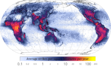
World map showing frequency of lightning strikes, in flashes per km² per year (equal-area projection). Lightning strikes most frequently in the Democratic Republic of the Congo. Combined 1995–2003 data from the Optical Transient Detector and 1998–2003 data from the Lightning Imaging Sensor.

Collisions between ice and soft hail (graupel) inside cumulonimbus clouds causes separation of positive and negative charges within the cloud, essential for the generation of lightning. How lightning initially forms is still a matter of debate: Scientists have studied root causes ranging from atmospheric perturbations (wind, humidity, and atmospheric pressure) to the impact of solar wind and energetic particles.

An average bolt of lightning carries a negative electric current of 40 kiloamperes (kA) (although some bolts can be up to 120 kA), and transfers a charge of five coulombs and energy of 500 MJ, or enough energy to power a 100-watt lightbulb for just under two months. The voltage depends on the length of the bolt, with the dielectric breakdown of air being three million volts per meter, and lightning bolts often being several hundred meters long. However, lightning leader development is not a simple matter of dielectric breakdown, and the ambient electric fields required for lightning leader propagation can be a few orders of magnitude less than dielectric breakdown strength. Further, the potential gradient inside a well-developed return-stroke channel is on the order of hundreds of volts per meter or less due to intense channel ionization, resulting in a true power output on the order of megawatts per meter for a vigorous return-stroke current of 100 kA .

If the quantity of water that is condensed in and subsequently precipitated from a cloud is known, then the total energy of a thunderstorm can be calculated. In an average thunderstorm, the energy released amounts to about 10,000,000 kilowatt-hours (3.6×10¹³ joule), which is equivalent to a 20-kiloton nuclear warhead. A large, severe thunderstorm might be 10 to 100 times more energetic.

Lightning sequence (Duration: 0.32 seconds)

Corona discharges

A depiction of atmospheric electricity in a Martian dust storm, which has been suggested as a possible explanation for enigmatic chemistry results from Mars

St. Elmo's Fire is an electrical phenomenon in which luminous plasma is created by a coronal discharge originating from a grounded object. Ball lightning is often erroneously identified as St. Elmo's Fire, whereas they are separate and distinct phenomena. Although referred to as "fire", St. Elmo's Fire is, in fact, plasma, and is observed, usually during a thunderstorm, at the tops of trees, spires or other tall objects, or on the heads of animals, as a brush or star of light.

Corona is caused by the electric field around the object in question ionizing the air molecules, producing a faint glow easily visible in low-light conditions. Approximately 1,000 – 30,000 volts per centimetre is required to induce St. Elmo's Fire; however, this is dependent on the geometry of the object in question. Sharp points tend to require lower voltage levels to produce the same result because electric fields are more concentrated in areas of high curvature, thus discharges are more intense at the end of pointed objects. St. Elmo's Fire and normal sparks both can appear when high electrical voltage affects a gas. St. Elmo's fire is seen during thunderstorms when the ground below the storm is electrically charged, and there is high voltage in the air between the cloud and the ground. The voltage tears apart the air molecules and the gas begins to glow. The nitrogen and oxygen in the Earth's atmosphere causes St. Elmo's Fire to fluoresce with blue or violet light; this is similar to the mechanism that causes neon signs to glow.

Earth-Ionosphere cavity

The Schumann resonances are a set of spectrum peaks in the extremely low frequency (ELF) portion of the Earth's electromagnetic field spectrum. Schumann resonance is due to the space between the surface of the Earth and the conductive ionosphere acting as a waveguide. The limited dimensions of the earth cause this waveguide to act as a resonant cavity for electromagnetic waves. The cavity is naturally excited by energy from lightning strikes.

Electrical system grounding

Atmospheric charges can cause undesirable, dangerous, and potentially lethal charge potential buildup in suspended electric wire power distribution systems. Bare wires suspended in the air spanning many kilometers and isolated from the ground can collect very large stored charges at high voltage, even when there is no thunderstorm or lightning occurring. This charge will seek to discharge itself through the path of least insulation, which can occur when a person reaches out to activate a power switch or to use an electric device.

To dissipate atmospheric charge buildup, one side of the electrical distribution system is connected to the earth at many points throughout the distribution system, as often as on every support pole. The one earth-connected wire is commonly referred to as the "protective earth", and provides path for the charge potential to dissipate without causing damage, and provides redundancy in case any one of the ground paths is poor due to corrosion or poor ground conductivity. The additional electric grounding wire that carries no power serves a secondary role, providing a high-current short-circuit path to rapidly blow fuses and render a damaged device safe, rather than have an ungrounded device with damaged insulation become "electrically live" via the grid power supply, and hazardous to touch.

Each transformer in an alternating current distribution grid segments the grounding system into a new separate circuit loop. These separate grids must also be grounded on one side to prevent charge buildup within them relative to the rest of the system, and which could cause damage from charge potentials discharging across the transformer coils to the other grounded side of the distribution network.

Saturday, October 16, 2021

Primordial soup

From Wikipedia, the free encyclopedia

Primordial soup, or prebiotic soup (also sometimes referred as prebiotic broth), is the hypothetical set of conditions present on the Earth around 4.0 to 3.7 billion years ago. It is a fundamental aspect to the heterotrophic theory of the origin of life, first proposed by Alexander Oparin in 1924, and John Burdon Sanderson Haldane in 1929.

Historical background

The notion that living beings originated from inanimate materials comes from the Ancient Greeks—the theory known as spontaneous generation. Aristotle in the 4th century BCE gave a proper explanation, writing:

So with animals, some spring from parent animals according to their kind, whilst others grow spontaneously and not from kindred stock; and of these instances of spontaneous generation some come from putrefying earth or vegetable matter, as is the case with a number of insects, while others are spontaneously generated in the inside of animals out of the secretions of their several organs.

— Aristotle, On the History of Animals, Book V, Part 1

Aristotle also states that it is not only that animals originate from other similar animals, but also that living things do arise and always have arisen from lifeless matter. His theory remained the dominant idea on origin of life (outside that of deity as a causal agent) from the ancient philosophers to the Renaissance thinkers in various forms. With the birth of modern science, experimental refutations emerged. Italian physician Francesco Redi demonstrated in 1668 that maggots developed from rotten meat only in a jar where flies could enter, but not in a closed-lid jar. He concluded that: omne vivum ex vivo (All life comes from life).

The experiment of French chemist Louis Pasteur in 1859 is regarded as the death blow to spontaneous generation. He experimentally showed that organisms (microbes) can not grow in sterilised water, unless it is exposed to air. The experiment won him the Alhumbert Prize in 1862 from the French Academy of Sciences, and he concluded: "Never will the doctrine of spontaneous generation recover from the mortal blow of this simple experiment."

Evolutionary biologists believed that a kind of spontaneous generation, but different from the simple Aristotelian doctrine, must have worked for the emergence of life. French biologist Jean-Baptiste de Lamarck had speculated that the first life form started from non-living materials. "Nature, by means of heat, light, electricity and moisture", he wrote in 1809 in Philosophie Zoologique (The Philosophy of Zoology), "forms direct or spontaneous generation at that extremity of each kingdom of living bodies, where the simplest of these bodies are found."

When English naturalist Charles Darwin introduced the theory of natural selection in his book On the Origin of Species in 1859, his supporters, such as a German zoologist Ernst Haeckel, criticised him for not using his theory to explain the origin of life. Haeckel wrote in 1862: "The chief defect of the Darwinian theory is that it throws no light on the origin of the primitive organism—probably a simple cell—from which all the others have descended. When Darwin assumes a special creative act for this first species, he is not consistent, and, I think, not quite sincere."

Although Darwin did not speak explicitly about the origin of life in On the Origin of Species, he did mention a "warm little pond" in a letter to Joseph Dalton Hooker dated February 1, 1871:

It is often said that all the conditions for the first production of a living being are now present, which could ever have been present. But if (and oh what a big if) we could conceive in some warm little pond with all sort of ammonia and phosphoric salts,—light, heat, electricity present, that a protein compound was chemically formed, ready to undergo still more complex changes, at the present such matter would be instantly devoured, or absorbed, which would not have been the case before living creatures were formed [...].

— Charles Darwin, Letter to Joseph Dalton Hooker on February 1, 1871

Heterotrophic theory

A coherent scientific argument was introduced by Soviet biochemist Alexander Oparin in 1924. According to Oparin, in the primitive Earth's surface, carbon, hydrogen, water vapour, and ammonia reacted to form the first organic compounds. Unbeknownst to Oparin, whose writing was circulated only in Russian, an English scientist John Burdon Sanderson Haldane independently arrived at a similar conclusion in 1929. It was Haldane who first used the term "soup" to describe the accumulation of organic material and water in the primitive Earth 

When ultra-violet light acts on a mixture of water, carbon dioxide, and ammonia, a vast variety of organic substances are made, including sugars and apparently some of the materials from which proteins are built up. [...] before the origin of life they must have accumulated till the primitive oceans reached the consistency of hot dilute soup.

— J. B. S. Haldane, The Origin of Life

Today the theory is variously known as the Heterotrophic theory, Heterotrophic origin of life theory or the Oparin-Haldane hypothesis. Biochemist Robert Shapiro has summarized the basic points of the theory in its "mature form" as follows: According to the heterotrophic theory, organic compounds were synthesized in the primitive Earth under prebiotic conditions. The mixture of such compounds with water under the atmosphere of the primitive Earth is referred as the prebiotic soup. There, life originated and the first forms of life were able use the organic molecules to survive and reproduce.

  1. Early Earth had a chemically reducing atmosphere.
  2. This atmosphere, exposed to energy in various forms, produced simple organic compounds ("monomers").
  3. These compounds accumulated in a "soup", which may have been concentrated at various locations (shorelines, oceanic vents etc.).
  4. By further transformation, more complex organic polymers – and ultimately life – developed in the soup.

Definitions

It is important to make the distinction between prebiotic and abiotic processes. While an abiotic process refers to anything that occurs without the presence of life, a prebiotic process refers to something that happens in the atmospheric and chemical conditions that the primitive Earth had about 4.2 billion years ago, and that preceded to the origin of life on the planet.

Oparin's theory

Alexander Oparin first postulated his theory in Russian in 1924 in a small pamphlet titled Proiskhozhdenie Zhizny (The Origin of Life). According to Oparin, the primitive Earth's surface had a thick red-hot liquid, composed of heavy elements such as carbon (in the form of iron carbide). This nucleus was surrounded by the lightest elements, i.e. gases, such as hydrogen. In the presence of water vapour, carbides reacted with hydrogen to form hydrocarbons. Such hydrocarbons were the first organic molecules. These further combined with oxygen and ammonia to produce hydroxy- and amino-derivatives, such as carbohydrates and proteins. These molecules accumulated on the ocean's surface, becoming gel-like substances and growing in size. They gave rise to primitive organisms (cells), which he called coacervates. In his original theory, Oparin considered oxygen as one of the primordial gases; thus the primordial atmosphere was an oxidising one. However, when he elaborated his theory in 1936 (in a book by the same title, and translated into English in 1938), he modified the chemical composition of the primordial environment as strictly reducing, consisting of methane, ammonia, free hydrogen and water vapour—excluding oxygen.

In his 1936 work, impregnated by a Darwinian thought that involved a slow and gradual evolution from the simple to the complex, Oparin proposed a heterotrophic origin, result of a long process of chemical and pre-biological evolution, where the first forms of life should have been microorganisms dependent on the molecules and organic substances present in their external environment. That external environment was the primordial soup.

The idea of a heterotrophic origin was based, in part, on the universality of fermentative reactions, which, according to Oparin, should have first appeared in evolution due to its simplicity. This was opposed to the idea, widely accepted at that time, that the first organisms emerged endowed with an autotrophic metabolism, which included photosynthetic pigments, enzymes and the ability to synthesize organic compounds from CO2 and H2O; for Oparin it was impossible to reconcile the original photosynthetic organisms with the ideas of Darwinian evolution.

From the detailed analysis of the geochemical and astronomical data known at that date, Oparin also proposed a primitive atmosphere devoid of O2 and composed of CH4, NH3 and H2O; under these conditions it was pointed out that the origin of life had been preceded by a period of abiotic synthesis and subsequent accumulation of various organic compounds in the seas of primitive Earth. This accumulation resulted in the formation of a primordial broth containing a wide variety of molecules.

There, according to Oparin, a particular type of colloid, the coacervates, were formed due to the conglomeration of organic molecules and other polymers with positive and negative charges. Oparin suggested that the first living beings had been preceded by pre-cellular structures similar to those coacervates, whose gradual evolution gave rise to the appearance of the first organisms.

Like the coacervates, several of Oparin's original ideas have been reformulated and replaced; this includes, for example, the reducing character of the atmosphere on primitive Earth, the coacervates as a pre-cellular model and the primitive nature of glycolysis. In the same way, we now understand that the gradual processes are not necessarily slow, and we even know, thanks to the fossil record, that the origin and early evolution of life occurred in short geologic time lapses.

However, the general approach of Oparin's theory had great implications for biology, since his work achieved the transformation of the study of the origin of life from a purely speculative field to a structured and broad research program. Thus, since the second half of the twentieth century, Oparin's theory of the origin and early evolution of life has undergone a restructuring that accommodates the experimental findings of molecular biology, as well as the theoretical contributions of evolutionary biology.

A point of convergence between these two branches of biology and that has been perfectly incorporated into the heterotrophic origin theory is found in the RNA world hypothesis.

Haldane's theory

J.B.S. Haldane independently postulated his primordial soup theory in 1929 in an eight-page article "The origin of life" in The Rationalist Annual. According to Haldane the primitive Earth's atmosphere was essentially reducing, with little or no oxygen. Ultraviolet rays from the Sun induced reactions on a mixture of water, carbon dioxide, and ammonia. Organic substances such as sugars and protein components (amino acids) were synthesised. These molecules "accumulated till the primitive oceans reached the consistency of hot dilute soup." The first reproducing things were created from this soup.

As to the priority over the theory, Haldane accepted that Oparin came first, saying, "I have very little doubt that Professor Oparin has the priority over me."

Monomer formation

One of the most important pieces of experimental support for the "soup" theory came in 1953. A graduate student, Stanley Miller, and his professor, Harold Urey, performed an experiment that demonstrated how organic molecules could have spontaneously formed from inorganic precursors, under conditions like those posited by the Oparin-Haldane Hypothesis. The now-famous "Miller–Urey experiment" used a highly reduced mixture of gases—methane, ammonia and hydrogen—to form basic organic monomers, such as amino acids. This provided direct experimental support for the second point of the "soup" theory, and it is one of the remaining two points of the theory that much of the debate now centers.

Apart from the Miller–Urey experiment, the next most important step in research on prebiotic organic synthesis was the demonstration by Joan Oró that the nucleic acid purine base, adenine, was formed by heating aqueous ammonium cyanide solutions. In support of abiogenesis in eutectic ice, more recent work demonstrated the formation of s-triazines (alternative nucleobases), pyrimidines (including cytosine and uracil), and adenine from urea solutions subjected to freeze-thaw cycles under a reductive atmosphere (with spark discharges as an energy source).

Further transformation

The spontaneous formation of complex polymers from abiotically generated monomers under the conditions posited by the "soup" theory is not at all a straightforward process. Besides the necessary basic organic monomers, compounds that would have prohibited the formation of polymers were formed in high concentration during the Miller–Urey and Oró experiments. The Miller experiment, for example, produces many substances that would undergo cross-reactions with the amino acids or terminate the peptide chain.

Friday, October 15, 2021

Geography of Tibet

From Wikipedia, the free encyclopedia
Jump to navigation Jump to search

The geography of Tibet consists of the high mountains, lakes and rivers lying between Central, East and South Asia. Traditionally, Western (European and American) sources have regarded Tibet as being in Central Asia, though today's maps show a trend toward considering all of modern China, including Tibet, to be part of East Asia. Tibet is often called "the roof of the world," comprising tablelands averaging over 4,950 metres above the sea with peaks at 6,000 to 7,500 m, including Mount Everest, on the border with Nepal.

Description

It is bounded on the north and east by the Central China Plain, on the west by the Kashmir Region of India and on the south by Nepal, India and Bhutan. Most of Tibet sits atop a geological structure known as the Tibetan Plateau, which includes the Himalaya and many of the highest mountain peaks in the world.

High mountain peaks include Changtse, Lhotse, Makalu, Gauri Sankar, Gurla Mandhata, Cho Oyu, Jomolhari, Gyachung Kang, Gyala Peri, Mount Kailash, Kawagebo, Khumbutse, Melungtse, Mount Nyainqentanglha, Namcha Barwa, Shishapangma and Yangra. Mountain passes include Cherko la and North Col. Smaller mountains include Mount Gephel and Gurla Mandhata.

Regions

Physically, Tibet may be divided into two parts, the "lake region" in the west and north-west, and the "river region", which spreads out on three sides of the former on the east, south, and west. The region names are useful in contrasting their hydrological structures, and also in contrasting their different cultural uses which is nomadic in the "lake region" and agricultural in the "river region". Despite its large size and mountainous nature, variation of climate across the Tibetan Plateau is more steady than abrupt. The "river region" has a subtropical highland climate with moderate summer rainfall averaging around 500 millimetres (20 in) per year, and daytime temperatures ranging from around 7 °C (45 °F) in winter to 24 °C (75 °F) in summer  though nights are as much as 15 °C (27 °F) cooler. Rainfall decreases steadily to the west, reaching only 110 millimetres (4.3 in) at Leh on the edge of this region, whilst temperatures in winter become steadily colder. On the south the "river region" is bounded by the Himalayas, on the north by a broad mountain system. The system at no point narrows to a single range; generally there are three or four across its breadth. As a whole the system forms the watershed between rivers flowing to the Indian Ocean – the Indus, Brahmaputra and Salween and its tributaries – and the streams flowing into the undrained salt lakes to the north.

The "river region" is characterized by fertile mountain valleys and includes the Yarlung Tsangpo River (the upper courses of the Brahmaputra) and its major tributary, the Nyang River, the Salween, the Yangtze, the Mekong, and the Yellow River. The Yarlung Tsangpo Canyon, formed by a horseshoe bend in the river where it flows around Namcha Barwa, is the deepest, and possibly longest canyon in the world. Among the mountains there are many narrow valleys. The valleys of Lhasa, Shigatse, Gyantse and the Brahmaputra are free from permafrost, covered with good soil and groves of trees, well irrigated, and richly cultivated.

The South Tibet Valley is formed by the Yarlung Zangbo River during its middle reaches, where it travels from west to east. The valley is approximately 1200 kilometers long and 300 kilometers wide. The valley descends from 4500 meters above sea level to 2800 meters. The mountains on either side of the valley are usually around 5000 meters high. Lakes here include Lake Paiku and Lake Puma Yumco.

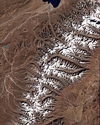
The "lake region" extends from the Pangong Tso Lake in Ladakh, Lake Rakshastal, Yamdrok Lake and Lake Manasarovar near the source of the Indus River, to the sources of the Salween, the Mekong and the Yangtze. Other lakes include Dagze Co, Nam Co, and Pagsum Co. The lake region is an arid and wind-swept desert. This region is called the Chang Tang (Byang thang) or 'Northern Plateau' by the people of Tibet. It is some 1100 km (700 mi) broad, and covers an area about equal to that of France. Due to the extremely high mountain barriers it has a very arid alpine climate with annual precipitation around 100 millimetres (4 in) and possesses no river outlet. The mountain ranges are spread out, rounded, disconnected, separated by flat valleys. The country is dotted over with large and small lakes, generally salt or alkaline, and intersected by streams. Due to the presence of discontinuous permafrost over the Chang Tang, the soil is boggy and covered with tussocks of grass, thus resembling the Siberian tundra. Salt and fresh-water lakes are intermingled. The lakes are generally without outlet, or have only a small effluent. The deposits consist of soda, potash, borax and common salt. The lake region is noted for a vast number of hot springs, which are widely distributed between the Himalaya and 34° N., but are most numerous to the west of Tengri Nor (north-west of Lhasa). So intense is the cold in this part of Tibet that these springs are sometimes represented by columns of ice, the nearly boiling water having frozen in the act of ejection.

The effects of climate change

The Tibetan Plateau contains the world's third-largest store of ice. Qin Dahe, the former head of the China Meteorological Administration, said that the recent fast pace of melting and warmer temperatures will be good for agriculture and tourism in the short term; but issued a strong warning:

"Temperatures are rising four times faster than elsewhere in China, and the Tibetan glaciers are retreating at a higher speed than in any other part of the world." "In the short term, this will cause lakes to expand and bring floods and mudflows." "In the long run, the glaciers are vital lifelines for Asian rivers, including the Indus and the Ganges. Once they vanish, water supplies in those regions will be in peril."

Tibet during the last glacial period

Today Tibet is the most essential heating surface of the atmosphere. During the Last glacial period a c. 2,400,000 square kilometres (930,000 sq mi) ice sheet covered the plateau. This glaciation took place in correspondence to a lowering of the snowline by 1,200 metres (3,900 ft). For the Last Glacial Maximum this means a depression of the average annual temperature by 7 to 8 °C (13 to 14 °F) at a minor precipitation compared with that one of today.

Owing to this drop in temperature a supposed drier climate has partly been compensated with regard to the glacier feeding by a minor evaporation and an increased relative humidity. Due to its great extension this glaciation in the subtropics was the most important climatically foreign element on earth. With an albedo about 80-90% this ice area of Tibet has reflected an at least 4 times greater global radiation energy per surface into space than the further inland ices at a higher geographical latitude. At that time the most essential heating surface of the atmosphere  which at present, i.e. interglacially, is the Tibetan plateau  was the most important cooling surface.

The annual low-pressure area induced by heat above Tibet as a motor of the summer monsoon was lacking. The glaciation thus caused a breaking-off of the summer monsoon with all the global-climatic consequences, e.g. the pluvials in the Sahara, the expansion of the Thar desert, the heavier dust influx into the Arabian Sea etc., and also the downward shifting of the timber line and all forest-belts from the alpine-boreal forests as far down as to the semi-humid mediterranean forest which has replaced the Holocene monsoon-tropical forests on the Indian subcontinent. But also the movements of animals including the Javan Rusa far into South Asia are a consequence of this glaciation.

Despite heavy ablation caused by heavy insolation, the discharge of the glaciers into the Inner-Asian basins was sufficient for the creation of meltwater lakes in the Qaidam Basin, the Tarim Basin and the Gobi Desert. The drop in temperature (see above) was in favour of their development. Thus, the clay fraction produced by the ground scouring of the important glaciation was ready to be blown-out. The blow-out of the limnites and the Aeolian long-distance transport were connected to the katabatic winds. Accordingly, the Tibetan glaciation was the actual cause of the enormous loess production and the transport of the material into the Chinese middle- and lowlands continuing to the east. During the Ice Age the katabatic air current  the name 'winter monsoon' is not quite correct  blew all year round.

The enormous uplift of Tibet by around 10 mm/year measured by triangulations since the 19th century and confirmed by glaciogemorphological findings as well as by seismological investigations equals the uplift of the Himalaya. However, these amounts of uplift are far too important as to a primarily tectonic uplift of the high plateau which only takes place epirogenetically. Actually they can be understood the better by a superimposed glacioisostatic compensation movement of Tibet about 650 m.

An alternative view held by some scientists is that the glaciers on the Tibetan Plateau have remained restricted over the entire data published since 1974 in the literature referred to in Kuhle (2004), which are relevant as to the maximum ice extent.

Operator (computer programming)

From Wikipedia, the free encyclopedia https://en.wikipedia.org/wiki/Operator_(computer_programmin...