Search This Blog

Thursday, April 23, 2020

Gates of the Arctic National Park and Preserve

From Wikipedia, the free encyclopedia
 
Gates of the Arctic National Park and Preserve
IUCN category V (protected landscape/seascape)
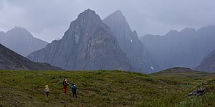
Oolah Valley (16089307144).jpg
Oolah Valley in the Itkillik Preserve
Map showing the location of Gates of the Arctic National Park and Preserve
Location in northern Alaska
LocationBettles, Alaska
Coordinates67°47′N 153°18′WCoordinates: 67°47′N 153°18′W
Area8,472,506 acres (34,287.02 km2)
EstablishedDecember 2, 1980
Visitors9,591 (in 2018)
Governing bodyNational Park Service
WebsiteOfficial website

Gates of the Arctic National Park and Preserve is an American national park that protects portions of the Brooks Range in northern Alaska. The park is the northernmost national park in the United States, situated entirely north of the Arctic Circle. The park is the second largest in the US at 8,472,506 acres (13,238 sq mi; 34,287 km2), slightly larger in area than Belgium. Gates of the Arctic was initially designated as a national monument on December 1, 1978, before being redesignated as a national park and preserve upon passage of the Alaska National Interest Lands Conservation Act in 1980. A large part of the park has additional protection as the Gates of the Arctic Wilderness which covers 7,167,192 acres (2,900,460 ha). The wilderness area adjoins the Noatak Wilderness and together they form the largest contiguous wilderness in the United States.

Activities

Hiking in the Brooks Range
Hikers in the Itkillik River drainage, a group of tilted sedimentary peaks in the central Brooks Range
 
There are no roads in Gates of the Arctic National Park and Preserve. Owing to its remoteness and lack of supportive infrastructure, the park is the least visited national park in the U.S., and one of the least visited areas in the entire U.S. National Park System, which also includes national monuments, recreation areas, preserves, and historic sites. In 2016, the park received just 10,047 visitors, while Grand Canyon National Park received nearly 6 million visitors (about 600 times as many) in the same year.

Camping is permitted throughout the park, but may be restricted by easements when crossing Native Corporation lands within the park.

The park headquarters is in Fairbanks. Park Service operations in the park are managed from the Bettles Ranger Station, to the south of the park.

Geography

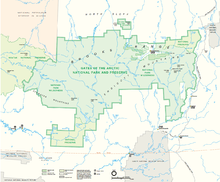
Park map
 
Gates of the Arctic National Park and Preserve lies to the west of the Dalton Highway, centered on the Brooks Range and covering the north and south slopes of the mountains. The park includes the Endicott Mountains and part of the Schwatka Mountains. The majority of Gates of the Arctic is designated as national park, in which only subsistence hunting by local rural residents is permitted. Sport hunting is only permitted in the national preserve. To hunt and trap in the preserve, a person must have all required licenses and permits and follow all other state regulations.

The eastern boundary of the park generally follows the Dalton Highway at a distance of a few miles, with the westernmost part of the Arctic National Wildlife Refuge 10 miles (16 km) farther east. Kanuti National Wildlife Refuge is near the park's southeast boundary. Noatak National Preserve adjoins the western boundary, and the National Petroleum Reserve–Alaska adjoins the northwest corner of the park. Almost all of the park is designated as wilderness, with the exception of areas around Anaktuvuk Pass. A detached portion of the park surrounds the outlying Fortress Mountain and Castle Mountain to the north of the park.

Ten small communities outside the park's boundaries are classified as "resident zone communities" and depend on park resources for food and livelihood. They are Alatna, Allakaket, Ambler, Anaktuvuk Pass, Bettles, Evansville, Hughes, Kobuk, Nuiqsut, Shungnak, and Wiseman. There are no established roads, trails, visitor facilities, or campgrounds in the park. The Dalton Highway (Alaska State Highway 11) comes within five miles (8 km) of the park's eastern boundary, but requires a river crossing to reach the park from the road. The Arctic Interagency Visitor Center in nearby Coldfoot is open from late May to early September, providing information on the parks, preserves and refuges of the Brooks Range, Yukon Valley and the North Slope. About 259,000 acres (105,000 ha) of the park and preserve are owned by native corporations or the State of Alaska. 7,263,000 acres (2,939,000 ha) are protected in the Gates of the Arctic Wilderness.

The park contains mountains such as the Arrigetch Peaks and Mount Igikpak. The park also features six Wild and Scenic Rivers:

Climate

According to the Köppen climate classification system, Gates of the Arctic National Park and Preserve has a Subarctic with Cool Summers and Year Around Rainfall Climate (Dfc). The plant hardiness zone at Anaktuvuk Pass Ranger Station is 2b with an average annual extreme minimum temperature of -42.6 °F (-41.4 °C).

Geology

Aerial view of mountains in summer
 
The park includes much of the central and eastern Brooks Range. It extends to the east as far as the Middle Fork of the Koyukuk River, which is paralleled by the Dalton Highway and the Trans-Alaska Pipeline. The park straddles the continental divide, separating the drainages of the Pacific and Arctic Oceans. The northernmost section of the park includes small portions of the Arctic foothills tundra. The Brooks Range occupies the central section of the park, running on an east-west line. To the south of the Brooks Range the Ambler-Chandalar Ridge, with associated valleys and lakes, runs east-west. The southernmost portion of the park includes the Kobuk-Selawik Lowlands, with the headwaters of the Kobuk River. The Brooks Range has seen repeated glaciation, with the most recent called the Itkillik glaciation from about 24,000 years ago to roughly 1500 to 1200 years before the present.

Ecology

Wolverine on the bank of the Noatak River

The boreal forest extends to about 68 degrees north latitude, characterized by black and white spruce mixed with poplar. To the north of that line, which coincides with the spine of the Brooks Range, lies cold-arid land that has been described as "Arctic desert." During the long winters temperatures can reach −75 °F (−59 °C), but can reach 90 °F (32 °C) for a short time in summer. The park lies above the Arctic circle.

Fauna include brown bears, black bears, muskoxen, moose, Dall sheep, timber wolves, wolverines, coyotes, Arctic and red foxes, lynxes, marmots, porcupines, river otters, beavers, snowshoe hares, muskrats, bald eagles, golden eagles, peregrine falcons, ospreys, great horned and northern hawk-owls. More than half a million caribou, including the Central Arctic, Western Arctic, Teshekpuk, and Porcupine herds, migrate through the central Brooks Range twice yearly, traveling north in summer, and south in winter. Caribou are important as a food source to native peoples. The park is the northernmost range limit for the Dall sheep. About 132 brown bears reside in the park and preserve, based on a density of about one bear per 100 square miles (260 km2).

History

Ancient seabed formations have weathered into cliffs, fins, pinnacles, and arches.
 
Nomadic peoples have inhabited the Brooks Range for as many as 12,500 years, living mainly on caribou and other wildlife. The Mesa site at Iteriak Creek has yielded evidence of occupation between 11,500 and 10,300 years before the present. Later sites from around 6,000 years before present have yielded projectile points, stone knives and net sinkers. The Arctic small tool tradition (ASTt) of about 4,500 BP has also been documented. A late phase of the ASTt from between 2500 and 950 BP, the Ipuitak phase, has been documented in the park at the Bateman Site at Itkillik Lake.

The earliest Inupiat people appeared about 1200 AD at the coast and spread to the Brooks Range, becoming the Nunamiut. The Nunamiut people, who had left much of their traditional homelands following a crash in the caribou populations in the early 1900s, resumed a relatively isolated subsistence way of life after returning to the mountains in the late 1930s. In 1949 the last two semi-nomadic bands came together in the valley of the Anaktuvuk River, and over the next decade established the community of Anaktuvuk Pass. The Gwich'in people, a Northern Athabaskan group also lived in the area in the last 1000 years, moving south of the park in historic times.

The Alaskan interior was not explored until the late 19th century, shortly before discovery of gold in the Klondike brought prospectors to Alaska. Some encampments of explorers and survey parties have been identified in the park. A few small mining operations were established in the early 20th century, never amounting to much.

The park's name dates to 1929, when wilderness activist Bob Marshall, exploring the North Fork of the Koyukuk River, encountered a pair of mountains (Frigid Crags and Boreal Mountain), one on each side of the river. He christened this portal the "Gates of the Arctic." Marshall spent time in Wiseman during the early 1930s, publishing an account of the place in his 1933 book Arctic Village. In the 1940s writer and researcher Olaus Murie proposed that Alaskan lands be preserved.

Proposals for a national park in the Brooks Range first emerged in the 1960s, and in 1968 a National Park Service survey team recommended the establishment of a 4,100,000-acre (1,700,000 ha) park in the area. That year, Secretary of the Interior Stewart Udall recommended to President Lyndon B. Johnson that Johnson use the Antiquities Act to proclaim a national monument in the Brooks Range and other Alaskan locations, but Johnson declined. During the 1970s the Alaska Native Claims Settlement Act (ANCSA) prompted serious examination of the disposition of lands held by the federal government. A series of bills were considered to deal with conservation land proposals authorized under ANCSA, but the legislation that would become the Alaska National Interest Lands Conservation Act (ANILCA) was held up in Congress in the late 1970s. Consequently, on December 1, 1978 President Jimmy Carter used the Antiquities Act to proclaim much of the proposed new Alaskan parklands as national monuments, including Gates of the Arctic National Monument. In 1980 Congress passed ANILCA, and the monument became Gates of the Arctic National Park and Preserve on December 2, 1980.

Looking southwest across Galbraith Lake into the northern section of the preserve, from the Dalton Highway

Bryce Canyon National Park

From Wikipedia, the free encyclopedia
https://en.wikipedia.org/wiki/Bryce_Canyon_National_Park

Bryce Canyon National Park
IUCN category II (national park)
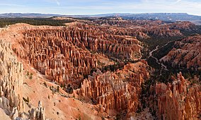
Inspiration Point Bryce Canyon November 2018 panorama.jpg
Map showing the location of Bryce Canyon National Park
LocationGarfield County and Kane County, Utah, United States
Nearest cityTropic, Panguitch
Coordinates37°37′42″N 112°10′04″WCoordinates: 37°37′42″N 112°10′04″W
Area35,835 acres (145.02 km2)
EstablishedFebruary 25, 1928
Visitors2,679,478 (in 2018)
Governing bodyNational Park Service
WebsiteOfficial website 

Bryce Canyon National Park (/brs/) is an American national park located in southwestern Utah. The major feature of the park is Bryce Canyon, which despite its name, is not a canyon, but a collection of giant natural amphitheaters along the eastern side of the Paunsaugunt Plateau. Bryce is distinctive due to geological structures called hoodoos, formed by frost weathering and stream erosion of the river and lake bed sedimentary rocks. The red, orange, and white colors of the rocks provide spectacular views for park visitors. Bryce Canyon National Park is much smaller, and sits at a much higher elevation than nearby Zion National Park. The rim at Bryce varies from 8,000 to 9,000 feet (2,400 to 2,700 m).

The Bryce Canyon area was settled by Mormon pioneers in the 1850s and was named after Ebenezer Bryce, who homesteaded in the area in 1874. The area around Bryce Canyon was originally designated as a national monument by President Warren G. Harding in 1923 and was redesignated as a national park by Congress in 1928. The park covers 35,835 acres (55.992 sq mi; 14,502 ha; 145.02 km2) and receives substantially fewer visitors than Zion National Park (nearly 4.3 million in 2016) or Grand Canyon National Park (nearly 6 million in 2016), largely due to Bryce's more remote location. In 2018, Bryce Canyon received 2,679,478 recreational visitors, which was an increase of 107,794 visitors from the prior year.

Geography

Bryce Canyon National Park lies within the Colorado Plateau geographic province of North America and straddles the southeastern edge of the Paunsaugunt Plateau west of the Paunsaugunt Fault (Paunsaugunt is Paiute for "home of the beaver"). Park visitors arrive from the plateau part of the park and look over the plateau's edge toward a valley containing the fault and the Paria River just beyond it (Paria is Paiute for "muddy or elk water"). The edge of the Kaiparowits Plateau bounds the opposite side of the valley. 

Bryce Canyon was not formed from erosion initiated from a central stream, meaning it technically is not a canyon. Instead headward erosion has excavated large amphitheater-shaped features in the Cenozoic-aged rocks of the Paunsaugunt Plateau. This erosion exposed delicate and colorful pinnacles called hoodoos that are up to 200 feet (60 m) high. A series of amphitheaters extends more than 20 miles (30 km) north-to-south within the park. The largest is Bryce Amphitheater, which is 12 miles (19 km) long, 3 miles (5 km) wide and 800 feet (240 m) deep. A nearby example of amphitheaters with hoodoos in the same formation but at a higher elevation, is in Cedar Breaks National Monument, which is 25 miles (40 km) to the west on the Markagunt Plateau.

Rainbow Point, the highest part of the park at 9,105 feet (2,775 m), is at the end of the 18-mile (29 km) scenic drive. From there, Aquarius Plateau, Bryce Amphitheater, the Henry Mountains, the Vermilion Cliffs and the White Cliffs can be seen. Yellow Creek, where it exits the park in the north-east section, is the lowest part of the park at 6,620 feet (2,020 m).

Bryce Amphitheater from Sunrise Point

Climate

According to the Köppen climate classification system, Bryce Canyon National Park has a Warm Summer humid continental climate (Dfb). Dfb climates are defined by their coldest month having an average mean temperature below −0 °C (32 °F), all months with an average mean temperature below 22 °C (71.6 °F), at least four months with an average mean temperature above 10 °C (50 °F), and no significant precipitation difference between seasons. The plant hardiness zone at the visitor center is 5b with an average annual extreme minimum air temperature of -10.0 °F (-23.3 °C) 
.
The national park is located in southwestern Utah about 50 miles (80 km) northeast of and 1,000 feet (300 m) higher than Zion National Park. The weather in Bryce Canyon is therefore cooler, and the park receives more precipitation: a total of 15 to 18 inches (380 to 460 mm) per year. Yearly temperatures vary from an average minimum of 9 °F (−13 °C) in January to an average maximum of 83 °F (28 °C) in July, but extreme temperatures can range from −30 to 97 °F (−34 to 36 °C). The record high temperature in the park was 98 °F (37 °C) on July 14, 2002. The record low temperature was −28 °F (−33 °C) on December 10, 1972.

Climate data for Bryce Canyon National Park headquarters (1981–2010)
Month Jan Feb Mar Apr May Jun Jul Aug Sep Oct Nov Dec Year
Record high °F (°C) 59
(15)
64
(18)
67
(19)
75
(24)
85
(29)
92
(33)
98
(37)
90
(32)
88
(31)
79
(26)
68
(20)
60
(16)
98
(37)
Average high °F (°C) 36.8
(2.7)
38.4
(3.6)
45.1
(7.3)
53.5
(11.9)
64.0
(17.8)
74.5
(23.6)
80.2
(26.8)
77.4
(25.2)
69.8
(21.0)
58.2
(14.6)
44.8
(7.1)
36.4
(2.4)
56.6
(13.7)
Daily mean °F (°C) 26.1
(−3.3)
27.6
(−2.4)
33.9
(1.1)
41.1
(5.1)
50.4
(10.2)
59.7
(15.4)
66.4
(19.1)
63.9
(17.7)
55.8
(13.2)
45.1
(7.3)
33.7
(0.9)
25.9
(−3.4)
44.1
(6.7)
Average low °F (°C) 15.4
(−9.2)
16.7
(−8.5)
22.7
(−5.2)
28.7
(−1.8)
36.9
(2.7)
44.8
(7.1)
52.6
(11.4)
50.3
(10.2)
41.8
(5.4)
32.0
(0.0)
22.6
(−5.2)
15.4
(−9.2)
31.7
(−0.2)
Record low °F (°C) −26
(−32)
−26
(−32)
−11
(−24)
−3
(−19)
13
(−11)
21
(−6)
28
(−2)
23
(−5)
16
(−9)
0
(−18)
−12
(−24)
−23
(−31)
−26
(−32)
Average precipitation inches (mm) 1.83
(46)
1.35
(34)
1.51
(38)
0.82
(21)
0.83
(21)
0.58
(15)
1.56
(40)
1.99
(51)
1.72
(44)
1.97
(50)
1.30
(33)
1.22
(31)
16.68
(424)
Average snowfall inches (cm) 19.7
(50)
18.0
(46)
16.0
(41)
6.1
(15)
0.8
(2.0)
0.2
(0.51)
0.0
(0.0)
0.0
(0.0)
0.1
(0.25)
2.9
(7.4)
11.1
(28)
14.7
(37)
89.6
(227.16)
Average precipitation days (≥ 0.01 in) 5.9 6.7 6.9 5.6 5.4 4.1 7.7 9.9 7.0 6.1 4.7 5.6 75.5
Average snowy days (≥ 0.1 in) 5.5 6.2 5.8 3.3 0.9 0.1 0.0 0.0 0.1 1.2 3.5 5.4 32.0
Mean daily sunshine hours 7.0 8.0 8.0 10.0 11.0 12.0 11.0 10.0 10.0 9.0 7.0 6.0 9.1
Percent possible sunshine 70 73 67 77 79 80 79 71 83 82 70 60 74
Average ultraviolet index 2 4 6 8 10 11 11 10 8 5 3 2 6.7

History

Native American habitation

Little is known about early human habitation in the Bryce Canyon area. Archaeological surveys of Bryce Canyon National Park and the Paunsaugunt Plateau show that people have been in the area for at least 10,000 years. Basketmaker Anasazi artifacts several thousand years old have been found south of the park. Other artifacts from the Pueblo-period Anasazi and the Fremont culture (up to the mid-12th century) have also been found.

The Paiute Indians moved into the surrounding valleys and plateaus in the area around the same time that the other cultures left. These Native Americans hunted and gathered for most of their food, but also supplemented their diet with some cultivated products. The Paiute in the area developed a mythology surrounding the hoodoos (pinnacles) in Bryce Canyon. They believed that hoodoos were the Legend People whom the trickster Coyote turned to stone. At least one older Paiute said his culture called the hoodoos Anka-ku-was-a-wits, which is Paiute for "red painted faces".

EuroAmerican exploration and settlement

Ebenezer Bryce and his family lived in this cabin below Bryce Amphitheater (c. 1881).
 
It was not until the late 18th and the early 19th century that the first European Americans explored the remote and hard-to-reach area. Mormon scouts visited the area in the 1850s to gauge its potential for agricultural development, use for grazing, and settlement.

The first major scientific expedition to the area was led by U.S. Army Major John Wesley Powell in 1872. Powell, along with a team of mapmakers and geologists, surveyed the Sevier and Virgin River area as part of a larger survey of the Colorado Plateaus. His mapmakers kept many of the Paiute place names.

Small groups of Mormon pioneers followed and attempted to settle east of Bryce Canyon along the Paria River. In 1873, the Kanarra Cattle Company started to use the area for cattle grazing.

The Church of Jesus Christ of Latter-day Saints sent Scottish immigrant Ebenezer Bryce and his wife Mary to settle land in the Paria Valley because they thought his carpentry skills would be useful in the area. The Bryce family chose to live right below Bryce Amphitheater—the main collection of hoodoos in the park. Bryce grazed his cattle inside what are now park borders, and reputedly thought that the amphitheaters were a "helluva place to lose a cow." He also built a road to the plateau to retrieve firewood and timber, and a canal to irrigate his crops and water his animals. Other settlers soon started to call the unusual place "Bryce's canyon", which was later formalized into Bryce Canyon. 

A combination of drought, overgrazing and flooding eventually drove the remaining Paiutes from the area and prompted the settlers to attempt construction of a water diversion channel from the Sevier River drainage. When that effort failed, most of the settlers, including the Bryce family, left the area. Bryce moved his family to Arizona in 1880. The remaining settlers dug a 10-mile (16 km) ditch from the Sevier's east fork into Tropic Valley.

Creation of the park

Bryce Canyon Lodge was built between 1924 and 1925 from local materials.
 
These scenic areas were first described for the public in magazine articles published by Union Pacific and Santa Fe railroads in 1916. People like Forest Supervisor J. W. Humphrey promoted the scenic wonders of Bryce Canyon's amphitheaters, and by 1918 nationally distributed articles also helped to spark interest. However, poor access to the remote area and the lack of accommodations kept visitation to a bare minimum.

Ruby Syrett, Harold Bowman and the Perry brothers later built modest lodging, and set up "touring services" in the area. Syrett later served as the first postmaster of Bryce Canyon. Visitation steadily increased, and by the early 1920s the Union Pacific Railroad became interested in expanding rail service into southwestern Utah to accommodate more tourists.

Two story wood building next to flag pole with U.S. flag waving in the wind. Snow on ground.
Visitor center in winter

At the same time, conservationists became alarmed by the damage overgrazing, logging, and unregulated visitation were having on the fragile features of Bryce Canyon. A movement to have the area protected was soon started, and National Park Service Director Stephen Mather responded by proposing that Bryce Canyon be made into a state park. The governor of Utah and the Utah State Legislature, however, lobbied for national protection of the area. Mather relented and sent his recommendation to President Warren G. Harding, who on June 8, 1923 declared Bryce Canyon a national monument.

A road was built the same year on the plateau to provide easy access to outlooks over the amphitheaters. From 1924 to 1925, Bryce Canyon Lodge was built from local timber and stone.

Members of the United States Congress started work in 1924 on upgrading Bryce Canyon's protection status from a national monument to a national park in order to establish Utah National Park. A process led by the Utah Parks Company for transferring ownership of private and state-held land in the monument to the federal government started in 1923. The last of the land in the proposed park's borders was sold to the federal government four years later, and on February 25, 1928, the renamed Bryce Canyon National Park was established.

In 1931, President Herbert Hoover annexed an adjoining area south of the park, and in 1942 an additional 635 acres (257 ha) was added. This brought the park's total area to the current figure of 35,835 acres (14,502 ha). Rim Road, the scenic drive that is still used today, was completed in 1934 by the Civilian Conservation Corps. Administration of the park was conducted from neighboring Zion National Park until 1956, when Bryce Canyon's first superintendent started work.

More recent history

The USS Bryce Canyon, which was named for the park, served as a supply and repair ship in the U.S. Pacific Fleet from September 15, 1950, to June 30, 1981.

Bryce Canyon Natural History Association (BCNHA) was established in 1961. It runs the bookstore inside the park visitor center and is a non-profit organization created to aid the interpretive, educational and scientific activities of the National Park Service at Bryce Canyon National Park. A portion of the profits from all bookstore sales are donated to public land units. 

Responding to increased visitation and traffic congestion, the National Park Service implemented a voluntary, summer-only, in-park shuttle system in June 2000. In 2004, reconstruction began on the aging and inadequate road system in the park. 

On April 7, 2020, Bryce Canyon National Park was closed to help prevent the spread of COVID-19.

Geology

A large opening in red rock with snow on top
Erosion of sedimentary rocks has created natural arches.

The Bryce Canyon area shows a record of deposition that spans from the last part of the Cretaceous period and the first half of the Cenozoic era. The ancient depositional environment of the region around what is now the park varied. The Dakota Sandstone and the Tropic Shale were deposited in the warm, shallow waters of the advancing and retreating Cretaceous Seaway (outcrops of these rocks are found just outside park borders). The colorful Claron Formation, from which the park's delicate hoodoos are carved, was laid down as sediments in a system of cool streams and lakes that existed from 63 to about 40 million years ago (from the Paleocene to the Eocene epochs). Different sediment types were laid down as the lakes deepened and became shallow and as the shoreline and river deltas migrated. 

Several other formations were also created but were mostly eroded away following two major periods of uplift. The Laramide orogeny affected the entire western part of what would become North America starting about 70 million to 50 million years ago. This event helped to build the Rocky Mountains and in the process closed the Cretaceous Seaway. The Straight Cliffs, Wahweap, and Kaiparowits formations were victims of this uplift. The Colorado Plateaus were uplifted 16 million years ago and were segmented into different plateaus, each separated from its neighbors by faults and each having its own uplift rate. The Boat Mesa Conglomerate and the Sevier River Formation were removed by erosion following this uplift.

Thor's Hammer
Thor's Hammer

This uplift created vertical joints, which over time were preferentially eroded. The soft Pink Cliffs of the Claron Formation were eroded to form freestanding pinnacles in badlands called hoodoos, while the more resistant White Cliffs formed monoliths. The brown, pink and red colors are from hematite (iron oxide; Fe
2
O
3
); the yellows from limonite (FeO(OH)·nH
2
O)
; and the purples are from pyrolusite (MnO
2
). Also created were arches, natural bridges, walls, and windows. Hoodoos are composed of soft sedimentary rock and are topped by a piece of harder, less easily eroded stone that protects the column from the elements. Bryce Canyon has one of the highest concentrations of hoodoos of any place on Earth.

The formations exposed in the area of the park are part of the Grand Staircase. The oldest members of this supersequence of rock units are exposed in the Grand Canyon, the intermediate ones in Zion National Park, and its youngest parts are laid bare in Bryce Canyon area. A small amount of overlap occurs in and around each park.

Ecology

Trees with snow on them
Bryce Canyon has extensive fir forests.
 
More than 400 native plant species live in the park. There are three life zones in the park based on elevation: the lowest areas of the park are dominated by dwarf forests of pinyon pine and juniper with manzanita, serviceberry, and antelope bitterbrush in between. Aspen, cottonwood, water birch, and willow grow along streams. Ponderosa pine forests cover the mid-elevations with blue spruce and Douglas fir in water-rich areas and manzanita and bitterbrush as underbrush. Douglas fir and white fir, along with aspen and Engelmann spruce, make up the forests on the Paunsaugunt Plateau. The harshest areas have limber pine and ancient Great Basin bristlecone pine, some more than 1,600 years old, holding on.

The forests and meadows of Bryce Canyon provide the habitat to support diverse animal life including foxes, badgers, porcupines, elk, black bears, bobcats, and woodpeckers. Mule deer are the most common large mammals in the park. Elk and pronghorn, which have been reintroduced nearby, sometimes venture into the park.

A mule deer fawn

Bryce Canyon National Park forms part of the habitat of three wildlife species that are listed under the Endangered Species Act: the Utah prairie dog, the California condor, and the southwestern willow flycatcher. The Utah prairie dog is a threatened species that was reintroduced to the park for conservation, and the largest protected population is found within the park's boundaries.

About 170 species of birds visit the park each year, including swifts and swallows. Most species migrate to warmer regions in winter, although jays, ravens, nuthatches, eagles, and owls stay. In winter, the mule deer, cougars, and coyotes migrate to lower elevations. Ground squirrels and marmots pass the winter in hibernation.

Eleven species of reptiles and four species of amphibians have been found in the park. Reptiles include the Great Basin rattlesnake, short-horned lizard, side-blotched lizard, striped whipsnake, and amphibians include the tiger salamander.

Also in the park are the black, lumpy, very slow-growing colonies of cryptobiotic soil, which are a mix of lichens, algae, fungi, and cyanobacteria. Together these organisms slow erosion, add nitrogen to soil, and help it to retain moisture.

Activities

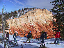
A line of snowshoers with colorful rock cliff in background.
Snowshoes are required for winter hiking.

Most park visitors sightsee using the scenic drive, which provides access to 13 viewpoints over the amphitheaters. Bryce Canyon has eight marked and maintained hiking trails that can be hiked in less than a day (round trip time, trailhead). Mossy Cave (one hour, State Route 12 northwest of Tropic), Rim Trail (5–6 hours, anywhere on rim), Bristlecone Loop (one hour, Rainbow Point), and Queens Garden (1–2 hours, Sunrise Point) are easy to moderate hikes. Navajo Loop (1–2 hours, Sunset Point) and Tower Bridge (2–3 hours, north of Sunrise Point) are moderate hikes. Fairyland Loop (4–5 hours, Fairyland Point) and Peekaboo Loop (3–4 hours, Bryce Point) are strenuous hikes. Several of these trails intersect, allowing hikers to combine routes for more challenging hikes. 

The park also has two trails designated for overnight hiking: the 9-mile (14 km) Riggs Spring Loop Trail and the 23-mile (37 km) Under-the-Rim Trail. Both require a backcountry camping permit. In total there are 50 miles (80 km) of trails in the park. 

Horseriders on a dirt trail going toward pillars of pink rock
Horseback riders in the park
 
More than 10 miles (16 km) of marked but ungroomed skiing trails are available off of Fairyland, Paria, and Rim trails in the park. Twenty miles (32 km) of connecting groomed ski trails are in nearby Dixie National Forest and Ruby's Inn.

The air in the area is so clear that on most days from Yovimpa and Rainbow points, Navajo Mountain and the Kaibab Plateau can be seen 90 miles (140 km) away in Arizona. On extremely clear days, the Black Mesas of eastern Arizona and western New Mexico can be seen some 160 miles (260 km) away.

The park also has a 7.4 magnitude night sky, making it one of the darkest in North America. Stargazers can, therefore, see 7,500 stars with the naked eye, while in most places fewer than 2,000 can be seen due to light pollution, and in many large cities only a few dozen can be seen. Park rangers host public stargazing events and evening programs on astronomy, nocturnal animals, and night sky protection. The Bryce Canyon Astronomy Festival, typically held in June, attracts thousands of visitors. In honor of this astronomy festival, Asteroid 49272 was named after the national park.

There are two campgrounds in the park, North Campground and Sunset Campground. Loop A in North Campground is open year-round. Additional loops and Sunset Campground are open from late spring to early autumn. The 114-room Bryce Canyon Lodge is another way to stay overnight in the park.

Korean philosophy

From Wikipedia, the free encyclopedia
 
Korean philosophy focused on a totality of world view. Some aspects of Shamanism, Buddhism, and Neo-Confucianism were integrated into Korean philosophy. Traditional Korean thought has been influenced by a number of religious and philosophical thought-systems over the years. As the main influences on life in Korea, often Korean Shamanism, Taoism, Buddhism, Confucianism and Silhak movements have shaped Korean life and thought.

Buddhism

Haeinsa is a Buddhist temple in South Gyeongsang.

Korean Buddhist thinkers refined ideas originally introduced from China into a distinct form. The Three Kingdoms of Korea introduced Buddhism to Japan, from where it was popularized in the West. Korean Buddhism consists mostly of the Seon lineage, which is derivative of the Chen (Zen) Buddhism of China and precursor to Zen Buddhism known in the West through Japan. 

Buddhist temples can be found in most parts of Korea and many are considered national treasures.

Confucianism

One of the most substantial influences in Korean intellectual history was the introduction of Confucian thought as part of the cultural exchange from China. Today the legacy of Confucianism remains a fundamental part of Korean society, shaping the moral system, the way of life, social relations between old and young, and high culture, and even survived the modernization of the legal system.

Schools of thought in the Joseon period

This dynasty arose out of the military dictatorships and chaos of the preceding era. Transition in this era was from Buddhism to a soldierly approach to Neo-Confucianism. Much work was done, especially on commentaries, and the Chu Hsi school represented indeed the golden age of Korean religious philosophy. Metaphysical research at this time investigated the theological relations between principle (i) and material/vital force (ki), and between as well the four beginnings (sadan), and the seven feelings (ch'ilchong); with the division of the Joseon Confucianists into two leading schools: one on "force" and one on "principles". The philosopher Hwadam ( Suh Kyungduk, 1489–1546 ) moved to integrate i and ki and spoke of Great Harmony (taehwa).

In the Four–Seven Debate with Ki Daesung, Toegye ( Yi Hwang, 1501 – 70 ), while being still dualistic, broke away from Chu Hsi by espousing the reciprocal emanation (hobal) of i and ki: with the Four, ki follows i when i becomes emanant; with the Seven, when ki becomes emanant, i ‘rides’ ki. Though he was critical of Toegye's idea that ki follows i as being dualistic, Yulgok (Yi I, 1536 – 84 ) nevertheless embraced his notion that i ‘rides’ ki: only ki is emanant and i moves its emanation; i and ki are ‘neither two things nor one thing’, as evidenced by ‘wondrous fusion’ (myohap). For Yulgok, original nature (i) and physical nature (ki) coalesce into one human nature. Toegye and Yulgok, whose thoughts culminated in an irenic fusionism, constituted the crowning phase of East Asian neo-Confucianism by exhibiting dialectical dexterity in articulating the concepts of i and ki, left unclarified by the Chinese. 

Toegye also developed the neo-Confucianist concept of single-mindedness (kyung), which was a manifestation of his unequivocal humanism, as shown by his total rejection of the Mandate of Heaven (chunmyung), which still had a hold on the Chinese, including Chu Hsi. Toegye's kyung synthesized the primeval Korean sense of supreme-efforts-come-earnest-devotion (chisung) with the Confucianist notion of holding fast to mind (jik-yung); he advocated self-efforts for creating a meaningful life. In particular, his concept of single-mindedness had a lasting influence on the Japanese neo-Confucianists of the Tokugawa period. 

Every major Korean neo-Confucianist shared Toegye's preoccupation with single-mindedness, which signalled new stress on praxis in the development of Korean neo-Confucianism: the fusion of the metaphysical and the physical is better brought about through action than speculation, important as theory might be. That was the point of Yulgok's integration of sincerity (sung) with single-mindedness. In this respect Korean neo-Confucianism made a break with the Cheng-Chu school of Chinese neo-Confucianism, which was overly speculative. 

During the later Joseon period, Silhak, a form of Neo-Confucianism, emerged. One of the most prominent Silhak philosophers was Jeong Yakyong.

Western philosophy in Korea, 1890–1945

Those who were sent to be educated in Japan, returned with limited knowledge of Western philosophy as a whole, although the German educational influence in Japan led to the beginning of interest in German idealists in Korea through indirect knowledge, with the exception of Marx, Hegel, and the dialecticians

The strong influence of low church Christianity, through missionary schools, led to practical American YMCA-style philosophy entering into Korea from the 1890s onwards. The discussion of Korean Christianity and Korean Christian philosophy is complicated with many divisions, and discussed in articles elsewhere. 

Philosophy in Korea was divided, by Western school, according to a kind of pragmatic mix of varied progressive libertarian beliefs in the south with highly variable changes from rigid authoritianism to softer and easier more pragmatic approaches from the 1990s onwards.

North Korean post-1945 philosophy

In the republican period, post-1945, Marxism–Leninism in the north was built on the Confucian yangban scholar-warriors of earlier times, if perhaps taken to absolutist extremes. 

The main influence in North Korea has been since 1996, the notion of "The Red Banner Spirit". This system of belief encourages the North Korean people to build a "kangsong taeguk", a fortress state, based on self-reliance and absolute loyalty to the leader (suryong). This philosophy was created by the "three generals of Mt. Paektu," referring to former North Korean leader Kim Jong-il, his father Kim Il-sung and his natural mother Kim Jong-suk. Again little is known of philosophical publications on this subject; but it appears to have replaced Marxism with a home-grown nationalistic ideology.

List of philosophers

Buddhist philosophers

Neo-Confucian philosophers

Taoist philosophers

Joseon period

These are listed by their most commonly used pen name, followed by their birth name.

Equality (mathematics)

From Wikipedia, the free encyclopedia https://en.wikipedia.org/wiki/Equality_...