Search This Blog

Monday, June 5, 2017

Future of Earth

From Wikipedia, the free encyclopedia

A dark gray and red sphere representing the scorched Earth lies against a black background to the right of an orange circular object representing the Sun
Conjectured illustration of the scorched Earth after the Sun has entered the red giant phase, about 7 billion years from now.[1]

The biological and geological future of Earth can be extrapolated based upon the estimated effects of several long-term influences. These include the chemistry at Earth's surface, the rate of cooling of the planet's interior, the gravitational interactions with other objects in the Solar System, and a steady increase in the Sun's luminosity. An uncertain factor in this extrapolation is the ongoing influence of technology introduced by humans, such as climate engineering,[2] which could cause significant changes to the planet.[3][4] The current Holocene extinction[5] is being caused by technology[6] and the effects may last for up to five million years.[7] In turn, technology may result in the extinction of humanity, leaving the planet to gradually return to a slower evolutionary pace resulting solely from long-term natural processes.[8][9]

Over time intervals of hundreds of millions of years, random celestial events pose a global risk to the biosphere, which can result in mass extinctions. These include impacts by comets or asteroids with diameters of 5–10 km (3.1–6.2 mi) or more, and the possibility of a massive stellar explosion, called a supernova, within a 100-light-year radius of the Sun, called a Near-Earth supernova. Other large-scale geological events are more predictable. If the long-term effects of global warming are disregarded, Milankovitch theory predicts that the planet will continue to undergo glacial periods at least until the Quaternary glaciation comes to an end. These periods are caused by variations in eccentricity, axial tilt, and precession of the Earth's orbit.[10] As part of the ongoing supercontinent cycle, plate tectonics will probably result in a supercontinent in 250–350 million years. Some time in the next 1.5–4.5 billion years, the axial tilt of the Earth may begin to undergo chaotic variations, with changes in the axial tilt of up to 90°.

During the next four billion years, the luminosity of the Sun will steadily increase, resulting in a rise in the solar radiation reaching the Earth. This will result in a higher rate of weathering of silicate minerals, which will cause a decrease in the level of carbon dioxide in the atmosphere. In about 600 million years from now, the level of CO2 will fall below the level needed to sustain C3 carbon fixation photosynthesis used by trees. Some plants use the C4 carbon fixation method, allowing them to persist at CO
2
concentrations as low as 10 parts per million. However, the long-term trend is for plant life to die off altogether. The extinction of plants will be the demise of almost all animal life, since plants are the base of the food chain on Earth.[11]

In about one billion years, the solar luminosity will be 10% higher than at present. This will cause the atmosphere to become a "moist greenhouse", resulting in a runaway evaporation of the oceans. As a likely consequence, plate tectonics will come to an end, and with them the entire carbon cycle.[12] Following this event, in about 2−3 billion years, the planet's magnetic dynamo may cease, causing the magnetosphere to decay and leading to an accelerated loss of volatiles from the outer atmosphere. Four billion years from now, the increase in the Earth's surface temperature will cause a runaway greenhouse effect, heating the surface enough to melt it. By that point, all life on the Earth will be extinct.[13][14] The most probable fate of the planet is absorption by the Sun in about 7.5 billion years, after the star has entered the red giant phase and expanded to cross the planet's current orbit.

Human influence

Humans play a key role in the biosphere, with the large human population dominating many of Earth's ecosystems.[3] This has resulted in a widespread, ongoing mass extinction of other species during the present geological epoch, now known as the Holocene extinction. The large-scale loss of species caused by human influence since the 1950s has been called a biotic crisis, with an estimated 10% of the total species lost as of 2007.[6] At current rates, about 30% of species are at risk of extinction in the next hundred years.[15] The Holocene extinction event is the result of habitat destruction, the widespread distribution of invasive species, hunting, and climate change.[16][17] In the present day, human activity has had a significant impact on the surface of the planet. More than a third of the land surface has been modified by human actions, and humans use about 20% of global primary production.[4] The concentration of carbon dioxide in the atmosphere has increased by close to 30% since the start of the Industrial Revolution.[3]
The consequences of a persistent biotic crisis have been predicted to last for at least five million years.[7] It could result in a decline in biodiversity and homogenization of biotas, accompanied by a proliferation of species that are opportunistic, such as pests and weeds. Novel species may also emerge; in particular taxa that prosper in human-dominated ecosystems may rapidly diversify into many new species. Microbes are likely to benefit from the increase in nutrient-enriched environmental niches. No new species of existing large vertebrates are likely to arise and food chains will probably be shortened.[5][18]

There are multiple scenarios for known risks that can have a global impact on the planet. From the perspective of humanity, these can be subdivided into survivable risks and terminal risks. Risks that humanity pose to itself include climate change, the misuse of nanotechnology, a nuclear holocaust, warfare with a programmed superintelligence, a genetically engineered disease, or a disaster caused by a physics experiment. Similarly, several natural events may pose a doomsday threat, including a highly virulent disease, the impact of an asteroid or comet, runaway greenhouse effect, and resource depletion. There may also be the possibility of an infestation by an extraterrestrial lifeform.[19] The actual odds of these scenarios are difficult if not impossible to deduce.[8][9]

Should the human race become extinct, then the various features assembled by humanity will begin to decay. The largest structures have an estimated decay half-life of about 1,000 years. The last surviving structures would most likely be open pit mines, large landfills, major highways, wide canal cuts, and earth-fill flank dams. A few massive stone monuments like the pyramids at the Giza Necropolis or the sculptures at Mount Rushmore may still survive in some form after a million years.[9][a]

Random events

The Barringer Meteorite Crater in Flagstaff, Arizona, showing evidence of the impact of celestial objects upon the Earth

As the Sun orbits the Milky Way, wandering stars may approach close enough to have a disruptive influence on the Solar System.[20] A close stellar encounter may cause a significant reduction in the perihelion distances of comets in the Oort cloud—a spherical region of icy bodies orbiting within half a light year of the Sun.[21] Such an encounter can trigger a 40-fold increase in the number of comets reaching the inner Solar System. Impacts from these comets can trigger a mass extinction of life on Earth. These disruptive encounters occur at an average of once every 45 million years.[22] The mean time for the Sun to collide with another star in the solar neighborhood is approximately 3 × 10¹³ years, which is much longer than the estimated age of the Milky Way galaxy, at ~1.3 × 10¹⁰ years. This can be taken as an indication of the low likelihood of such an event occurring during the lifetime of the Earth.[23]

The energy release from the impact of an asteroid or comet with a diameter of 5–10 km (3.1–6.2 mi) or larger is sufficient to create a global environmental disaster and cause a statistically significant increase in the number of species extinctions. Among the deleterious effects resulting from a major impact event is a cloud of fine dust ejecta blanketing the planet, which lowers land temperatures by about 15 °C (27 °F) within a week and halts photosynthesis for several months. The mean time between major impacts is estimated to be at least 100 million years. During the last 540 million years, simulations demonstrated that such an impact rate is sufficient to cause 5–6 mass extinctions and 20–30 lower severity events. This matches the geologic record of significant extinctions during the Phanerozoic Eon. Such events can be expected to continue into the future.[24]

A supernova is a cataclysmic explosion of a star. Within the Milky Way galaxy, supernova explosions occur on average once every 40 years.[25] During the history of the Earth, multiple such events have likely occurred within a distance of 100 light years. Explosions inside this distance can contaminate the planet with radioisotopes and possibly impact the biosphere.[26] Gamma rays emitted by a supernova react with nitrogen in the atmosphere, producing nitrous oxides. These molecules cause a depletion of the ozone layer that protects the surface from ultraviolet radiation from the Sun. An increase in UV-B radiation of only 10–30% is sufficient to cause a significant impact to life; particularly to the phytoplankton that form the base of the oceanic food chain. A supernova explosion at a distance of 26 light years will reduce the ozone column density by half. On average, a supernova explosion occurs within 32 light years once every few hundred million years, resulting in a depletion of the ozone layer lasting several centuries.[27] Over the next two billion years, there will be about 20 supernova explosions and one gamma ray burst that will have a significant impact on the planet's biosphere.[28]

The incremental effect of gravitational perturbations between the planets causes the inner Solar System as a whole to behave chaotically over long time periods. This does not significantly affect the stability of the Solar System over intervals of a few million years or less, but over billions of years the orbits of the planets become unpredictable. Computer simulations of the Solar System's evolution over the next five billion years suggest that there is a small (less than 1%) chance that a collision could occur between Earth and either Mercury, Venus, or Mars.[29][30] During the same interval, the odds that the Earth will be scattered out of the Solar System by a passing star are on the order of one part in 105. In such a scenario, the oceans would freeze solid within several million years, leaving only a few pockets of liquid water about 14 km (8.7 mi) underground. There is a remote chance that the Earth will instead be captured by a passing binary star system, allowing the planet's biosphere to remain intact. The odds of this happening are about one chance in three million.[31]

Orbit and rotation

The gravitational perturbations of the other planets in the Solar System combine to modify the orbit of the Earth and the orientation of its spin axis. These changes can influence the planetary climate.[10][32][33][34]

Glaciation

Historically, there have been cyclical ice ages in which glacial sheets periodically covered the higher latitudes of the continents. Ice ages may occur because of changes in ocean circulation and continentality induced by plate tectonics.[35] The Milankovitch theory predicts that glacial periods occur during ice ages because of astronomical factors in combination with climate feedback mechanisms. The primary astronomical drivers are a higher than normal orbital eccentricity, a low axial tilt (or obliquity), and the alignment of summer solstice with the aphelion.[10] Each of these effects occur cyclically. For example, the eccentricity changes over time cycles of about 100,000 and 400,000 years, with the value ranging from less than 0.01 up to 0.05.[36][37] This is equivalent to a change of the semiminor axis of the planet's orbit from 99.95% of the semimajor axis to 99.88%, respectively.[38]

The Earth is passing through an ice age known as the quaternary glaciation, and is presently in the Holocene interglacial period. This period would normally be expected to end in about 25,000 years.[34] However, the increased rate of carbon dioxide release into the atmosphere by humans may delay the onset of the next glacial period until at least 50,000–130,000 years from now. On the other hand, a global warming period of finite duration (based on the assumption that fossil fuel use will cease by the year 2200) will probably only impact the glacial period for about 5,000 years. Thus, a brief period of global warming induced through a few centuries worth of greenhouse gas emission would only have a limited impact in the long term.[10]

Obliquity

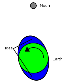
A small gray circle at the top represents the Moon. A green circle centered in a blue ellipse represents the Earth and its oceans. A curved arrow shows the counterclockwise direction of the Earth's rotation, resulting in the long axis of the ellipse being slightly out of alignment with the Moon.
The rotational offset of the tidal bulge exerts a net torque on the Moon, boosting it while slowing the Earth's rotation. This image is not to scale.

The tidal acceleration of the Moon slows the rotation rate of the Earth and increases the Earth-Moon distance. Friction effects—between the core and mantle and between the atmosphere and surface—can dissipate the Earth's rotational energy. These combined effects are expected to increase the length of the day by more than 1.5 hours over the next 250 million years, and to increase the obliquity by about a half degree. The distance to the Moon will increase by about 1.5 Earth radii during the same period.[39]

Based on computer models, the presence of the Moon appears to stabilize the obliquity of the Earth, which may help the planet to avoid dramatic climate changes.[40] This stability is achieved because the Moon increases the precession rate of the Earth's spin axis (that is, the precession motion of the ecliptic), thereby avoiding resonances between the precession of the spin and precession of the planet's orbital plane relative to that of Jupiter.[41] However, as the semimajor axis of the Moon's orbit continues to increase, this stabilizing effect will diminish. At some point, perturbation effects will probably cause chaotic variations in the obliquity of the Earth, and the axial tilt may change by angles as high as 90° from the plane of the orbit. This is expected to occur between 1.5 and 4.5 billion years from now.[42]

A high obliquity would probably result in dramatic changes in the climate and may destroy the planet's habitability.[33] When the axial tilt of the Earth exceeds 54°, the yearly insolation at the equator is less than that at the poles. The planet could remain at an obliquity of 60° to 90° for periods as long as 10 million years.[43]

Geodynamics

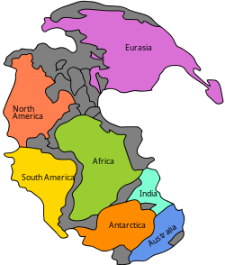
An irregular green shape against a blue background represents Pangaea.
Pangaea was the last supercontinent to form before the present.

Tectonics-based events will continue to occur well into the future and the surface will be steadily reshaped by tectonic uplift, extrusions, and erosion. Mount Vesuvius can be expected to erupt about 40 times over the next 1,000 years. During the same period, about five to seven earthquakes of magnitude 8 or greater should occur along the San Andreas Fault, while about 50 magnitude 9 events may be expected worldwide. Mauna Loa should experience about 200 eruptions over the next 1,000 years, and the Old Faithful Geyser will likely cease to operate. The Niagara Falls will continue to retreat upstream, reaching Buffalo in about 30,000–50,000 years.[9]

In 10,000 years, the post-glacial rebound of the Baltic Sea will have reduced the depth by about 90 m (300 ft). The Hudson Bay will decrease in depth by 100 m over the same period.[30] After 100,000 years, the island of Hawaii will have shifted about 9 km (5.6 mi) to the northwest. The planet may be entering another glacial period by this time.[9]

Continental drift

The theory of plate tectonics demonstrates that the continents of the Earth are moving across the surface at the rate of a few centimeters per year. This is expected to continue, causing the plates to relocate and collide. Continental drift is facilitated by two factors: the energy generation within the planet and the presence of a hydrosphere. With the loss of either of these, continental drift will come to a halt.[44] The production of heat through radiogenic processes is sufficient to maintain mantle convection and plate subduction for at least the next 1.1 billion years.[45]

At present, the continents of North and South America are moving westward from Africa and Europe. Researchers have produced several scenarios about how this will continue in the future.[46] These geodynamic models can be distinguished by the subduction flux, whereby the oceanic crust moves under a continent. In the introversion model, the younger, interior, Atlantic ocean becomes preferentially subducted and the current migration of North and South America is reversed. In the extroversion model, the older, exterior, Pacific ocean remains preferentially subducted and North and South America migrate toward eastern Asia.[47][48]

As the understanding of geodynamics improves, these models will be subject to revision. In 2008, for example, a computer simulation was used to predict that a reorganization of the mantle convection will occur over the next 100 million years, causing a supercontinent composed of Africa, Eurasia, Australia, Antarctica and South America to form around Antarctica.[49]

Regardless of the outcome of the continental migration, the continued subduction process causes water to be transported to the mantle. After a billion years from the present, a geophysical model gives an estimate that 27% of the current ocean mass will have been subducted. If this process were to continue unmodified into the future, the subduction and release would reach an equilibrium after 65% of the current ocean mass has been subducted.[50]

Introversion

A rough approximation of Pangaea Ultima, one of the three models for a future supercontinent.

Christopher Scotese and his colleagues have mapped out the predicted motions several hundred million years into the future as part of the Paleomap Project.[46] In their scenario, 50 million years from now the Mediterranean sea may vanish and the collision between Europe and Africa will create a long mountain range extending to the current location of the Persian Gulf. Australia will merge with Indonesia, and Baja California will slide northward along the coast. New subduction zones may appear off the eastern coast of North and South America, and mountain chains will form along those coastlines. To the south, the migration of Antarctica to the north will cause all of its ice sheets to melt. This, along with the melting of the Greenland ice sheets, will raise the average ocean level by 90 m (300 ft). The inland flooding of the continents will result in climate changes.[46]

As this scenario continues, by 100 million years from the present the continental spreading will have reached its maximum extent and the continents will then begin to coalesce. In 250 million years, North America will collide with Africa while South America will wrap around the southern tip of Africa. The result will be the formation of a new supercontinent (sometimes called Pangaea Ultima), with the Pacific Ocean stretching across half the planet. The continent of Antarctica will reverse direction and return to the South Pole, building up a new ice cap.[51]

Extroversion

The first scientist to extrapolate the current motions of the continents was Canadian geologist Paul F. Hoffman of Harvard University. In 1992, Hoffman predicted that the continents of North and South America would continue to advance across the Pacific Ocean, pivoting about Siberia until they begin to merge with Asia. He dubbed the resulting supercontinent, Amasia.[52][53] Later, in the 1990s, Roy Livermore calculated a similar scenario. He predicted that Antarctica would start to migrate northward, and east Africa and Madagascar would move across the Indian Ocean to collide with Asia.[54]

In an extroversion model, the closure of the Pacific Ocean would be complete in about 350 million years.[55] This marks the completion of the current supercontinent cycle, wherein the continents split apart and then rejoin each other about every 400–500 million years.[56] Once the supercontinent is built, plate tectonics may enter a period of inactivity as the rate of subduction drops by an order of magnitude. This period of stability could cause an increase in the mantle temperature at the rate of 30–100 °C (54–180 °F) every 100 million years, which is the minimum lifetime of past supercontinents. As a consequence, volcanic activity may increase.[48][55]

Supercontinent

The formation of a supercontinent can dramatically affect the environment. The collision of plates will result in mountain building, thereby shifting weather patterns. Sea levels may fall because of increased glaciation.[57] The rate of surface weathering can rise, resulting in an increase in the rate that organic material is buried. Supercontinents can cause a drop in global temperatures and an increase in atmospheric oxygen. This, in turn, can affect the climate, further lowering temperatures. All of these changes can result in more rapid biological evolution as new niches emerge.[58]

The formation of a supercontinent insulates the mantle. The flow of heat will be concentrated, resulting in volcanism and the flooding of large areas with basalt. Rifts will form and the supercontinent will split up once more.[59] The planet may then experience a warming period, as occurred during the Cretaceous period.[58]

Solidification of the outer core

The iron-rich core region of the Earth is divided into a 1,220 km (760 mi) radius solid inner core and a 3,480 km (2,160 mi) radius liquid outer core.[60] The rotation of the Earth creates convective eddies in the outer core region that cause it to function as a dynamo.[61] This generates a magnetosphere about the Earth that deflects particles from the solar wind, which prevents significant erosion of the atmosphere from sputtering. As heat from the core is transferred outward toward the mantle, the net trend is for the inner boundary of the liquid outer core region to freeze, thereby releasing thermal energy and causing the solid inner core to grow.[62] This iron crystallization process has been ongoing for about a billion years. In the modern era, the radius of the inner core is expanding at an average rate of roughly 0.5 mm (0.02 in) per year, at the expense of the outer core.[63] Nearly all of the energy needed to power the dynamo is being supplied by this process of inner core formation.[64]
The growth of the inner core may be expected to consume most of the outer core by some 3–4 billion years from now, resulting in a nearly solid core composed of iron and other heavy elements. The surviving liquid envelope will mainly consist of lighter elements that will undergo less mixing.[65] Alternatively, if at some point plate tectonics comes to an end, the interior will cool less efficiently, which may end the growth of the inner core. In either case, this can result in the loss of the magnetic dynamo. Without a functioning dynamo, the magnetic field of the Earth will decay in a geologically short time period of roughly 10,000 years.[66] The loss of the magnetosphere will cause an increase in erosion of light elements, particularly hydrogen, from the Earth's outer atmosphere into space, resulting in less favorable conditions for life.[67]

Solar evolution

The energy generation of the Sun is based upon thermonuclear fusion of hydrogen into helium. This occurs in the core region of the star using the proton–proton chain reaction process. Because there is no convection in the solar core, the helium concentration builds up in that region without being distributed throughout the star. The temperature at the core of the Sun is too low for nuclear fusion of helium atoms through the triple-alpha process, so these atoms do not contribute to the net energy generation that is needed to maintain hydrostatic equilibrium of the Sun.[68]
At present, nearly half the hydrogen at the core has been consumed, with the remainder of the atoms consisting primarily of helium. As the number of hydrogen atoms per unit mass decreases, so too does their energy output provided through nuclear fusion. This results in a decrease in pressure support, which causes the core to contract until the increased density and temperature bring the core pressure into equilibrium with the layers above. The higher temperature causes the remaining hydrogen to undergo fusion at a more rapid rate, thereby generating the energy needed to maintain the equilibrium.[68]
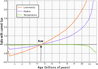
Evolution of the Sun's luminosity, radius and effective temperature compared to the present Sun. After Ribas (2010).[69]

The result of this process has been a steady increase in the energy output of the Sun. When the Sun first became a main sequence star, it radiated only 70% of the current luminosity. The luminosity has increased in a nearly linear fashion to the present, rising by 1% every 110 million years.[70] Likewise, in three billion years the Sun is expected to be 33% more luminous. The hydrogen fuel at the core will finally be exhausted in five billion years, when the Sun will be 67% more luminous than at present. Thereafter the Sun will continue to burn hydrogen in a shell surrounding its core, until the luminosity reaches 121% above the present value. This marks the end of the Sun's main sequence lifetime, and thereafter it will pass through the subgiant stage and evolve into a red giant.[1]

By this time, the collision of the Milky Way and Andromeda galaxies should be underway. Although this could result in the Solar System being ejected from the newly combined galaxy, it is considered unlikely to have any adverse effect on the Sun or planets.[71][72]

Climate impact

The rate of weathering of silicate minerals will increase as rising temperatures speed up chemical processes. This in turn will decrease the level of carbon dioxide in the atmosphere, as these weathering processes convert carbon dioxide gas into solid carbonates. Within the next 600 million years from the present, the concentration of CO
2
will fall below the critical threshold needed to sustain C3 photosynthesis: about 50 parts per million. At this point, trees and forests in their current forms will no longer be able to survive,[73] the last living trees being evergreen conifers.[74] However, C4 carbon fixation can continue at much lower concentrations, down to above 10 parts per million. Thus plants using C4 photosynthesis may be able to survive for at least 0.8 billion years and possibly as long as 1.2 billion years from now, after which rising temperatures will make the biosphere unsustainable.[75][76][77] Currently, C4 plants represent about 5% of Earth's plant biomass and 1% of its known plant species.[78] For example, about 50% of all grass species (Poaceae) use the C4 photosynthetic pathway,[79] as do many species in the herbaceous family Amaranthaceae.[80]

When the levels of carbon dioxide fall to the limit where photosynthesis is barely sustainable, the proportion of carbon dioxide in the atmosphere is expected to oscillate up and down. This will allow land vegetation to flourish each time the level of carbon dioxide rises due to tectonic activity and animal life. However, the long term trend is for the plant life on land to die off altogether as most of the remaining carbon in the atmosphere becomes sequestered in the Earth.[81] Some microbes are capable of photosynthesis at concentrations of CO
2
of a few parts per million, so these life forms would probably disappear only because of rising temperatures and the loss of the biosphere.[75]

Plants—and, by extension, animals—could survive longer by evolving other strategies such as requiring less CO
2
for photosynthetic processes, becoming carnivorous, adapting to desiccation, or associating with fungi. These adaptations are likely to appear near the beginning of the moist greenhouse (see further).[74]

The loss of plant life will also result in the eventual loss of oxygen as well as ozone due to the respiration of animals, chemical reactions in the atmosphere, and volcanic eruptions, meaning less attenuation of DNA-damaging ultraviolet radiation,[74] as well as the death of animals; the first animals to disappear would be large mammals, followed by small mammals, birds, amphibians and large fish, reptiles and small fish, and finally invertebrates. Before this happened it's expected that life would concentrate at refugia of lower temperature such as high elevations where less land surface area is available, thus restricting population sizes. Smaller animals would survive better than larger ones because of lesser oxygen requirements, while birds would fare better than mammals thanks to their ability to travel large distances looking for colder temperatures.[11]

In their work The Life and Death of Planet Earth, authors Peter D. Ward and Donald Brownlee have argued that some form of animal life may continue even after most of the Earth's plant life has disappeared. Ward and Brownlee use fossil evidence from the Burgess Shale in British Columbia, Canada, to determine the climate of the Cambrian Explosion, and use it to predict the climate of the future when rising global temperatures caused by a warming Sun and declining oxygen levels result in the final extinction of animal life. Initially, they expect that some insects, lizards, birds and small mammals may persist, along with sea life. However, without oxygen replenishment by plant life, they believe that animals would probably die off from asphyxiation within a few million years. Even if sufficient oxygen were to remain in the atmosphere through the persistence of some form of photosynthesis, the steady rise in global temperature would result in a gradual loss of biodiversity.[81]

As temperatures continue to rise, the last animal life will be driven back toward the poles, and possibly underground. They would become primarily active during the polar night, aestivating during the polar day due to the intense heat. Much of the surface would become a barren desert and life would primarily be found in the oceans.[81] However, due to a decrease of the amount or organic matter coming to the oceans from the land as well as oxygen in the water,[74] life would disappear there too following a similar path to that on Earth's surface. This process would start with the loss of freshwater species and conclude with invertebrates,[11] particularly those that do not depend on living plants such as termites or those near hydrothermal vents such as worms of the genus Riftia.[74] As a result of these processes, multi-cellular lifeforms may be extinct in about 800 million years, and eukaryotes in 1.3 billion years, leaving only the prokaryotes.[82]

Loss of oceans

Light brown clouds wrap around a planet, as seen from space.
The atmosphere of Venus is in a "supergreenhouse" state.

One billion years from now, about 27% of the modern ocean will have been subducted into the mantle. If this process were allowed to continue uninterrupted, it would reach an equilibrium state where 65% of the current surface reservoir would remain at the surface.[50] Once the solar luminosity is 10% higher than its current value, the average global surface temperature will rise to 320 K (47 °C; 116 °F). The atmosphere will become a "moist greenhouse" leading to a runaway evaporation of the oceans.[83][84] At this point, models of the Earth's future environment demonstrate that the stratosphere would contain increasing levels of water. These water molecules will be broken down through photodissociation by solar ultraviolet radiation, allowing hydrogen to escape the atmosphere. The net result would be a loss of the world's sea water by about 1.1 billion years from the present.[85][86] This will be a simple dramatic step in annihilating all life on Earth.

There will be two variations of this future warming feedback: the "moist greenhouse" where water vapor dominates the troposphere while water vapor starts to accumulate in the stratosphere (if the oceans evaporate very quickly), and the "runaway greenhouse" where water vapor becomes a dominant component of the atmosphere (if the oceans evaporate too slowly). The Earth will undergo rapid warming that could send its surface temperature to over 900 °C (1,650 °F) as the atmosphere will be totally overwhelmed by water vapor, causing its entire surface to melt and killing all life, perhaps in about three billion years. In this ocean-free era, there will continue to be surface reservoirs as water is steadily released from the deep crust and mantle,[50] where it is estimated there is an amount of water equivalent to several times that currently present in the Earth's oceans.[87] Some water may be retained at the poles and there may be occasional rainstorms, but for the most part the planet would be a dry desert with large dunefields covering its equator, and a few salt flats on what was once the ocean floor, similar to the ones in the Atacama Desert in Chile.[12]

With no water to lubricate them, plate tectonics would very likely stop and the most visible signs of geological activity would be shield volcanoes located above mantle hotspots.[74] In these arid conditions the planet may retain some microbial and possibly even multi-cellular life.[84] Most of these microbes will be halophiles and life could find too refuge in the atmosphere as has been proposed that could have happened on Venus.[74] However, the increasingly extreme conditions will likely lead to the extinction of the prokaryotes between 1.6 billion years[82] and 2.8 billion years from now, with the last of them living in residual ponds of water at high latitudes and heights or in caverns with trapped ice; underground life, however, could last longer.[11] What happens next depends on the level of tectonic activity. A steady release of carbon dioxide by volcanic eruption could cause the atmosphere to enter a "supergreenhouse" state like that of the planet Venus. But as stated above without surface water, plate tectonics would probably come to a halt and most of the carbonates would remain securely buried[12] until the Sun became a red giant and its increased luminosity heated the rock to the point of releasing the carbon dioxide.[87]

The loss of the oceans could be delayed until two billion years in the future if the total atmospheric pressure were to decline. A lower atmospheric pressure would reduce the greenhouse effect, thereby lowering the surface temperature. This could occur if natural processes were to remove the nitrogen from the atmosphere. Studies of organic sediments has shown that at least 100 kilopascals (0.99 atm) of nitrogen has been removed from the atmosphere over the past four billion years; enough to effectively double the current atmospheric pressure if it were to be released. This rate of removal would be sufficient to counter the effects of increasing solar luminosity for the next two billion years.[88]

By 2.8 billion years from now, the surface temperature of the Earth will have reached 422 K (149 °C; 300 °F), even at the poles. At this point, any remaining life will be extinguished due to the extreme conditions. If the Earth loses its surface water by this point, the planet will stay in the same conditions until the Sun becomes a red giant.[84] If this scenario doesn't happen, then in about 3–4 billion years the amount of water vapour in the lower atmosphere will rise to 40% and a moist greenhouse effect will commence[88] once the luminosity from the Sun reaches 35–40% more than its present-day value.[85] A "runaway greenhouse" effect will ensue, causing the atmosphere to heat up and raising the surface temperature to around 1,600 K (1,330 °C; 2,420 °F). This is sufficient to melt the surface of the planet.[86][84] However, most of the atmosphere will be retained until the Sun has entered the red giant stage.[89]

With the extinction of life, 2.8 billion years from now, it is also expected that Earth biosignatures will disappear, to be replaced by signatures caused by non-biological processes.[74]

Red giant stage

A large red disk represents the Sun as a red giant. An inset box shows the current Sun as a yellow dot.
The size of the current Sun (now in the main sequence) compared to its estimated size during its red giant phase

Once the Sun changes from burning hydrogen at its core to burning hydrogen around its shell, the core will start to contract and the outer envelope will expand. The total luminosity will steadily increase over the following billion years until it reaches 2,730 times the Sun's current luminosity at the age of 12.167 billion years. Most of Earth's atmosphere will be lost to space and its surface will consist of a lava ocean with floating continents of metals and metal oxides as well as icebergs of refractory materials, with its surface temperature reaching more than 2,400 K (2,130 °C; 3,860 °F).[90] The Sun will experience more rapid mass loss, with about 33% of its total mass shed with the solar wind. The loss of mass will mean that the orbits of the planets will expand. The orbital distance of the Earth will increase to at most 150% of its current value.[70]

The most rapid part of the Sun's expansion into a red giant will occur during the final stages, when the Sun will be about 12 billion years old. It is likely to expand to swallow both Mercury and Venus, reaching a maximum radius of 1.2 AU (180,000,000 km). The Earth will interact tidally with the Sun's outer atmosphere, which would serve to decrease Earth's orbital radius. Drag from the chromosphere of the Sun would also reduce the Earth's orbit. These effects will act to counterbalance the effect of mass loss by the Sun, and the Earth will probably be engulfed by the Sun.[70]

The drag from the solar atmosphere may cause the orbit of the Moon to decay. Once the orbit of the Moon closes to a distance of 18,470 km (11,480 mi), it will cross the Earth's Roche limit. This means that tidal interaction with the Earth would break apart the Moon, turning it into a ring system. Most of the orbiting ring will then begin to decay, and the debris will impact the Earth. Hence, even if the Earth is not swallowed up by the Sun, the planet may be left moonless.[91] The ablation and vaporization caused by its fall on a decaying trajectory towards the Sun may remove Earth's crust and mantle, then finally destroy it after at most 200 years.[92][93] Following this event, Earth's sole legacy will be a very slight increase (0.01%) of the solar metallicity.[94]§IIC

Alternatively, should the Earth survive being engulfed to the Sun, the ablation and vaporization mentioned before may strip both its crust and mantle leaving just its core.[93]

Post red-giant stage

The Helix nebula, a planetary nebula similar to what the Sun will produce in 8 billion years.

After fusing helium in its core to carbon, the Sun will begin to collapse again, evolving into a compact white dwarf star after ejecting its outer atmosphere as a planetary nebula. In 50 billion years, if the Earth and Moon are not engulfed by the Sun, they will become tidelocked, with each showing only one face to the other.[95][96] Thereafter, the tidal action of the Sun will extract angular momentum from the system, causing the lunar orbit to decay and the Earth's spin to accelerate.[97]

In about 65 billion years, it estimated that the Moon may end up colliding with the Earth, assuming they are not destroyed by the red giant Sun, due to the remaining energy of the Earth–Moon system being sapped by the remnant Sun, causing the Moon to slowly move inwards toward the Earth.[98]

Over time intervals of around 30 trillion years, the Sun will undergo a close encounter with another star. As a consequence, the orbits of their planets can become disrupted, potentially ejecting them from the system entirely.[99] If Earth is not destroyed by the expanding red giant Sun in 7.6 billion years and not ejected from its orbit by a stellar encounter, its ultimate fate will be that it collides with the black dwarf Sun due to the decay of its orbit via gravitational radiation, in 1020 (100 quintillion) years.[100]

Ice age

From Wikipedia, the free encyclopedia

An artist's impression of ice age Earth at glacial maximum. Based on: Crowley, T. J. (1995). "Ice age terrestrial carbon changes revisited". Global Biogeochemical Cycles. 9 (3): 377–389. Bibcode:1995GBioC...9..377C. doi:10.1029/95GB01107.

An ice age is a period of long-term reduction in the temperature of Earth's surface and atmosphere, resulting in the presence or expansion of continental and polar ice sheets and alpine glaciers. Within a long-term ice age, individual pulses of cold climate are termed "glacial periods" (or alternatively "glacials" or "glaciations" or colloquially as "ice age"), and intermittent warm periods are called "interglacials". In the terminology of glaciology, ice age implies the presence of extensive ice sheets in both northern and southern hemispheres.[1] By this definition, we are in an interglacial period—the Holocene—of the ice age. The ice age began 2.6 million years ago at the start of the Pleistocene epoch, because the Greenland, Arctic, and Antarctic ice sheets still exist.[2]

Origin of ice age theory

In 1742 Pierre Martel (1706–1767), an engineer and geographer living in Geneva, visited the valley of Chamonix in the Alps of Savoy.[3][4] Two years later he published an account of his journey. He reported that the inhabitants of that valley attributed the dispersal of erratic boulders to the glaciers, saying that they had once extended much farther.[5][6] Later similar explanations were reported from other regions of the Alps. In 1815 the carpenter and chamois hunter Jean-Pierre Perraudin (1767–1858) explained erratic boulders in the Val de Bagnes in the Swiss canton of Valais as being due to glaciers previously extending further.[7] An unknown woodcutter from Meiringen in the Bernese Oberland advocated a similar idea in a discussion with the Swiss-German geologist Jean de Charpentier (1786–1855) in 1834.[8] Comparable explanations are also known from the Val de Ferret in the Valais and the Seeland in western Switzerland[9] and in Goethe's scientific work.[10] Such explanations could also be found in other parts of the world. When the Bavarian naturalist Ernst von Bibra (1806–1878) visited the Chilean Andes in 1849–1850, the natives attributed fossil moraines to the former action of glaciers.[11]

Meanwhile, European scholars had begun to wonder what had caused the dispersal of erratic material. From the middle of the 18th century, some discussed ice as a means of transport. The Swedish mining expert Daniel Tilas (1712–1772) was, in 1742, the first person to suggest drifting sea ice in order to explain the presence of erratic boulders in the Scandinavian and Baltic regions.[12] In 1795, the Scottish philosopher and gentleman naturalist, James Hutton (1726–1797), explained erratic boulders in the Alps by the action of glaciers.[13] Two decades later, in 1818, the Swedish botanist Göran Wahlenberg (1780–1851) published his theory of a glaciation of the Scandinavian peninsula. He regarded glaciation as a regional phenomenon.[14]

The Antarctic ice sheet. Ice sheets expand during an ice age.

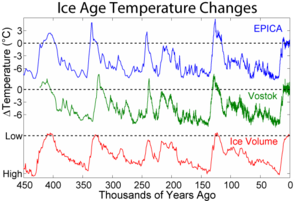
Variations in temperature, CO2, and dust from the Vostok ice core over the last 400,000 years

Only a few years later, the Danish-Norwegian geologist Jens Esmark (1762–1839) argued a sequence of worldwide ice ages. In a paper published in 1824, Esmark proposed changes in climate as the cause of those glaciations. He attempted to show that they originated from changes in Earth's orbit.[15] During the following years, Esmark's ideas were discussed and taken over in parts by Swedish, Scottish and German scientists. At the University of Edinburgh Robert Jameson (1774–1854) seemed to be relatively open to Esmark's ideas, as reviewed by Norwegian professor of glaciology Bjørn G. Andersen (1992).[16] Jameson's remarks about ancient glaciers in Scotland were most probably prompted by Esmark.[17] In Germany, Albrecht Reinhard Bernhardi (1797–1849), a geologist and professor of forestry at an academy in Dreissigacker, since incorporated in the southern Thuringian city of Meiningen, adopted Esmark's theory. In a paper published in 1832, Bernhardi speculated about former polar ice caps reaching as far as the temperate zones of the globe.[18]

In 1829, independently of these debates, the Swiss civil engineer Ignaz Venetz (1788–1859) explained the dispersal of erratic boulders in the Alps, the nearby Jura Mountains, and the North German Plain as being due to huge glaciers. When he read his paper before the Schweizerische Naturforschende Gesellschaft, most scientists remained sceptical.[19] Finally, Venetz convinced his friend Jean de Charpentier. De Charpentier transformed Venetz's idea into a theory with a glaciation limited to the Alps. His thoughts resembled Wahlenberg's theory. In fact, both men shared the same volcanistic, or in de Charpentier's case rather plutonistic assumptions, about the Earth's history. In 1834, de Charpentier presented his paper before the Schweizerische Naturforschende Gesellschaft.[20] In the meantime, the German botanist Karl Friedrich Schimper (1803–1867) was studying mosses which were growing on erratic boulders in the alpine upland of Bavaria. He began to wonder where such masses of stone had come from. During the summer of 1835 he made some excursions to the Bavarian Alps. Schimper came to the conclusion that ice must have been the means of transport for the boulders in the alpine upland. In the winter of 1835 to 1836 he held some lectures in Munich. Schimper then assumed that there must have been global times of obliteration ("Verödungszeiten") with a cold climate and frozen water.[21] Schimper spent the summer months of 1836 at Devens, near Bex, in the Swiss Alps with his former university friend Louis Agassiz (1801–1873) and Jean de Charpentier. Schimper, de Charpentier and possibly Venetz convinced Agassiz that there had been a time of glaciation. During the winter of 1836/37, Agassiz and Schimper developed the theory of a sequence of glaciations. They mainly drew upon the preceding works of Venetz, de Charpentier and on their own fieldwork. Agassiz appears to have been already familiar with Bernhardi's paper at that time.[22] At the beginning of 1837, Schimper coined the term "ice age" ("Eiszeit") for the period of the glaciers.[23] In July 1837 Agassiz presented their synthesis before the annual meeting of the Schweizerische Naturforschende Gesellschaft at Neuchâtel. The audience was very critical and some opposed to the new theory because it contradicted the established opinions on climatic history. Most contemporary scientists thought that the Earth had been gradually cooling down since its birth as a molten globe.[24]

In order to overcome this rejection, Agassiz embarked on geological fieldwork. He published his book Study on Glaciers ("Études sur les glaciers") in 1840.[25] De Charpentier was put out by this, as he had also been preparing a book about the glaciation of the Alps. De Charpentier felt that Agassiz should have given him precedence as it was he who had introduced Agassiz to in-depth glacial research.[26] Besides that, Agassiz had, as a result of personal quarrels, omitted any mention of Schimper in his book.[27]

All together, it took several decades until the ice age theory was fully accepted by scientists. This happened on an international scale in the second half of the 1870s following the work of James Croll, including the publication of Climate and Time, in Their Geological Relations in 1875, which provided a credible explanation for the causes of ice ages.[28]

Evidence for ice ages

There are three main types of evidence for ice ages: geological, chemical, and paleontological.
Geological evidence for ice ages comes in various forms, including rock scouring and scratching, glacial moraines, drumlins, valley cutting, and the deposition of till or tillites and glacial erratics. Successive glaciations tend to distort and erase the geological evidence, making it difficult to interpret. Furthermore, this evidence was difficult to date exactly; early theories assumed that the glacials were short compared to the long interglacials. The advent of sediment and ice cores revealed the true situation: glacials are long, interglacials short. It took some time for the current theory to be worked out.

The chemical evidence mainly consists of variations in the ratios of isotopes in fossils present in sediments and sedimentary rocks and ocean sediment cores. For the most recent glacial periods ice cores provide climate proxies from their ice, and atmospheric samples from included bubbles of air. Because water containing heavier isotopes has a higher heat of evaporation, its proportion decreases with colder conditions.[29] This allows a temperature record to be constructed. However, this evidence can be confounded by other factors recorded by isotope ratios.

The paleontological evidence consists of changes in the geographical distribution of fossils. During a glacial period cold-adapted organisms spread into lower latitudes, and organisms that prefer warmer conditions become extinct or are squeezed into lower latitudes. This evidence is also difficult to interpret because it requires (1) sequences of sediments covering a long period of time, over a wide range of latitudes and which are easily correlated; (2) ancient organisms which survive for several million years without change and whose temperature preferences are easily diagnosed; and (3) the finding of the relevant fossils.

Despite the difficulties, analysis of ice core and ocean sediment cores[30] has shown periods of glacials and interglacials over the past few million years. These also confirm the linkage between ice ages and continental crust phenomena such as glacial moraines, drumlins, and glacial erratics. Hence the continental crust phenomena are accepted as good evidence of earlier ice ages when they are found in layers created much earlier than the time range for which ice cores and ocean sediment cores are available.

Major ice ages


Timeline of glaciations, shown in blue.

There have been at least five major ice ages in the earth's past (the Huronian, Cryogenian, Andean-Saharan, Karoo Ice Age and the Quaternary glaciation). Outside these ages, the Earth seems to have been ice-free even in high latitudes.[31][32]

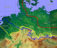
Ice age map of northern Germany and its northern neighbours. Red: maximum limit of Weichselian glacial; yellow: Saale glacial at maximum (Drenthe stage); blue: Elster glacial maximum glaciation.

Rocks from the earliest well established ice age, called the Huronian, formed around 2.4 to 2.1 Ga (billion years) ago during the early Proterozoic Eon. Several hundreds of km of the Huronian Supergroup are exposed 10–100 km north of the north shore of Lake Huron extending from near Sault Ste. Marie to Sudbury, northeast of Lake Huron, with giant layers of now-lithified till beds, dropstones, varves, outwash, and scoured basement rocks. Correlative Huronian deposits have been found near Marquette, Michigan, and correlation has been made with Paleoproterozoic glacial deposits from Western Australia.

The next well-documented ice age, and probably the most severe of the last billion years, occurred from 850 to 630 million years ago (the Cryogenian period) and may have produced a Snowball Earth in which glacial ice sheets reached the equator,[33] possibly being ended by the accumulation of greenhouse gases such as CO2 produced by volcanoes. "The presence of ice on the continents and pack ice on the oceans would inhibit both silicate weathering and photosynthesis, which are the two major sinks for CO2 at present."[34] It has been suggested that the end of this ice age was responsible for the subsequent Ediacaran and Cambrian explosion, though this model is recent and controversial.

The Andean-Saharan occurred from 460 to 420 million years ago, during the Late Ordovician and the Silurian period.

Sediment records showing the fluctuating sequences of glacials and interglacials during the last several million years.

The evolution of land plants at the onset of the Devonian period caused a long term increase in planetary oxygen levels and reduction of CO2 levels, which resulted in the Karoo Ice Age. It is named after the glacial tills found in the Karoo region of South Africa, where evidence for this ice age was first clearly identified. There were extensive polar ice caps at intervals from 360 to 260 million years ago in South Africa during the Carboniferous and early Permian Periods. Correlatives are known from Argentina, also in the center of the ancient supercontinent Gondwanaland.

The current ice age, the Pliocene-Quaternary glaciation, started about 2.58 million years ago during the late Pliocene, when the spread of ice sheets in the Northern Hemisphere began. Since then, the world has seen cycles of glaciation with ice sheets advancing and retreating on 40,000- and 100,000-year time scales called glacial periods, glacials or glacial advances, and interglacial periods, interglacials or glacial retreats. The earth is currently in an interglacial, and the last glacial period ended about 10,000 years ago. All that remains of the continental ice sheets are the Greenland and Antarctic ice sheets and smaller glaciers such as on Baffin Island.

Ice ages can be further divided by location and time; for example, the names Riss (180,000–130,000 years bp) and Würm (70,000–10,000 years bp) refer specifically to glaciation in the Alpine region. The maximum extent of the ice is not maintained for the full interval. The scouring action of each glaciation tends to remove most of the evidence of prior ice sheets almost completely, except in regions where the later sheet does not achieve full coverage.

Evidence of a recent, extreme ice age on Mars was published by the journal Science in 2016. Just 370,000 years ago, the planet would have appeared more white than red.[35]

Glacials and interglacials


Shows the pattern of temperature and ice volume changes associated with recent glacials and interglacials
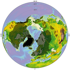
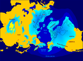
Minimum and maximum glaciation
Minimum (interglacial, black) and maximum (glacial, grey) glaciation of the northern hemisphere
Minimum (interglacial, black) and maximum (glacial, grey) glaciation of the southern hemisphere

Within the ice ages (or at least within the current one), more temperate and more severe periods occur. The colder periods are called glacial periods, the warmer periods interglacials, such as the Eemian Stage.

Glacials are characterized by cooler and drier climates over most of the earth and large land and sea ice masses extending outward from the poles. Mountain glaciers in otherwise unglaciated areas extend to lower elevations due to a lower snow line. Sea levels drop due to the removal of large volumes of water above sea level in the icecaps. There is evidence that ocean circulation patterns are disrupted by glaciations. Since the earth has significant continental glaciation in the Arctic and Antarctic, we are currently in a glacial minimum of a glaciation. Such a period between glacial maxima is known as an interglacial. The glacials and interglacials also coincided with changes in Earth's orbit called Milankovitch cycles.

The earth has been in an interglacial period known as the Holocene for more than 11,000 years. It was conventional wisdom that the typical interglacial period lasts about 12,000 years, but this has been called into question recently. For example, an article in Nature[36] argues that the current interglacial might be most analogous to a previous interglacial that lasted 28,000 years. Predicted changes in orbital forcing suggest that the next glacial period would begin at least 50,000 years from now, even in absence of human-made global warming[37] (see Milankovitch cycles). Moreover, anthropogenic forcing from increased greenhouse gases might outweigh orbital forcing for as long as intensive use of fossil fuels continues.[38]

Positive and negative feedback in glacial periods

Each glacial period is subject to positive feedback which makes it more severe, and negative feedback which mitigates and (in all cases so far) eventually ends it.

Positive feedback processes

Ice and snow increase Earth's albedo, i.e. they make it reflect more of the sun's energy and absorb less. Hence, when the air temperature decreases, ice and snow fields grow, and this continues until competition with a negative feedback mechanism forces the system to an equilibrium. Also, the reduction in forests caused by the ice's expansion increases albedo.

Another theory proposed by Ewing and Donn in 1956[39] hypothesized that an ice-free Arctic Ocean leads to increased snowfall at high latitudes. When low-temperature ice covers the Arctic Ocean there is little evaporation or sublimation and the polar regions are quite dry in terms of precipitation, comparable to the amount found in mid-latitude deserts. This low precipitation allows high-latitude snowfalls to melt during the summer. An ice-free Arctic Ocean absorbs solar radiation during the long summer days, and evaporates more water into the Arctic atmosphere. With higher precipitation, portions of this snow may not melt during the summer and so glacial ice can form at lower altitudes and more southerly latitudes, reducing the temperatures over land by increased albedo as noted above. Furthermore, under this hypothesis the lack of oceanic pack ice allows increased exchange of waters between the Arctic and the North Atlantic Oceans, warming the Arctic and cooling the North Atlantic. (Current projected consequences of global warming include a largely ice-free Arctic Ocean within 5–20 years, see Arctic shrinkage.) Additional fresh water flowing into the North Atlantic during a warming cycle may also reduce the global ocean water circulation. Such a reduction (by reducing the effects of the Gulf Stream) would have a cooling effect on northern Europe, which in turn would lead to increased low-latitude snow retention during the summer. It has also been suggested that during an extensive glacial, glaciers may move through the Gulf of Saint Lawrence, extending into the North Atlantic Ocean far enough to block the Gulf Stream.

Negative feedback processes

Ice sheets that form during glaciations cause erosion of the land beneath them. After some time, this will reduce land above sea level and thus diminish the amount of space on which ice sheets can form. This mitigates the albedo feedback, as does the lowering in sea level that accompanies the formation of ice sheets[citation needed].

Another factor is the increased aridity occurring with glacial maxima, which reduces the precipitation available to maintain glaciation. The glacial retreat induced by this or any other process can be amplified by similar inverse positive feedbacks as for glacial advances.[40]

According to research published in Nature Geoscience, human emissions of carbon dioxide (CO2) will defer the next ice age. Researchers used data on Earth's orbit to find the historical warm interglacial period that looks most like the current one and from this have predicted that the next ice age would usually begin within 1,500 years. They go on to say that emissions have been so high that it will not.[41]

Causes of ice ages

The causes of ice ages are not fully understood for either the large-scale ice age periods or the smaller ebb and flow of glacial–interglacial periods within an ice age. The consensus is that several factors are important: atmospheric composition, such as the concentrations of carbon dioxide and methane (the specific levels of the previously mentioned gases are now able to be seen with the new ice core samples from EPICA Dome C in Antarctica over the past 800,000 years) changes in the earth's orbit around the Sun known as Milankovitch cycles, the motion of tectonic plates resulting in changes in the relative location and amount of continental and oceanic crust on the earth's surface, which affect wind and ocean currents, variations in solar output, the orbital dynamics of the Earth–Moon system, the impact of relatively large meteorites and volcanism including eruptions of supervolcanoes.[42][citation needed]

Some of these factors influence each other. For example, changes in Earth's atmospheric composition (especially the concentrations of greenhouse gases) may alter the climate, while climate change itself can change the atmospheric composition (for example by changing the rate at which weathering removes CO2).

Maureen Raymo, William Ruddiman and others propose that the Tibetan and Colorado Plateaus are immense CO2 "scrubbers" with a capacity to remove enough CO2 from the global atmosphere to be a significant causal factor of the 40 million year Cenozoic Cooling trend. They further claim that approximately half of their uplift (and CO2 "scrubbing" capacity) occurred in the past 10 million years.[43][44]

Changes in Earth's atmosphere

There is evidence that greenhouse gas levels fell at the start of ice ages and rose during the retreat of the ice sheets, but it is difficult to establish cause and effect (see the notes above on the role of weathering). Greenhouse gas levels may also have been affected by other factors which have been proposed as causes of ice ages, such as the movement of continents and volcanism.

The Snowball Earth hypothesis maintains that the severe freezing in the late Proterozoic was ended by an increase in CO2 levels in the atmosphere, mainly from volcanoes, and some supporters of Snowball Earth argue that it was caused in the first place by a reduction in atmospheric CO2. The hypothesis also warns of future Snowball Earths.

In 2009, further evidence was provided that changes in solar insolation provide the initial trigger for the earth to warm after an Ice Age, with secondary factors like increases in greenhouse gases accounting for the magnitude of the change.[45]

Human-induced changes

There is considerable evidence that over the very recent period of the last 100–1000 years, the sharp increases in human activity, especially the burning of fossil fuels, has caused the parallel sharp and accelerating increase in atmospheric greenhouse gases which trap the sun's heat. The consensus theory of the scientific community is that the resulting greenhouse effect is a principal cause of the increase in global warming which has occurred over the same period, and a chief contributor to the accelerated melting of the remaining glaciers and polar ice. A 2012 investigation finds that dinosaurs released methane through digestion in a similar amount to humanity's current methane release, which "could have been a key factor" to the very warm climate 150 million years ago.[46]

William Ruddiman has proposed the early anthropocene hypothesis, according to which the anthropocene era, as some people call the most recent period in the earth's history when the activities of the human species first began to have a significant global impact on the earth's climate and ecosystems, did not begin in the 18th century with the advent of the Industrial Era, but dates back to 8,000 years ago, due to intense farming activities of our early agrarian ancestors. It was at that time that atmospheric greenhouse gas concentrations stopped following the periodic pattern of the Milankovitch cycles. In his overdue-glaciation hypothesis Ruddiman states that an incipient glacial would probably have begun several thousand years ago, but the arrival of that scheduled glacial was forestalled by the activities of early farmers.[47]

At a meeting of the American Geophysical Union (December 17, 2008), scientists detailed evidence in support of the controversial idea that the introduction of large-scale rice agriculture in Asia, coupled with extensive deforestation in Europe began to alter world climate by pumping significant amounts of greenhouse gases into the atmosphere over the last 1,000 years. In turn, a warmer atmosphere heated the oceans making them much less efficient storehouses of carbon dioxide and reinforcing global warming, possibly forestalling the onset of a new glacial age.[48]

Position of the continents

The geological record appears to show that ice ages start when the continents are in positions which block or reduce the flow of warm water from the equator to the poles and thus allow ice sheets to form. The ice sheets increase Earth's reflectivity and thus reduce the absorption of solar radiation. With less radiation absorbed the atmosphere cools; the cooling allows the ice sheets to grow, which further increases reflectivity in a positive feedback loop. The ice age continues until the reduction in weathering causes an increase in the greenhouse effect.

There are three known configurations of the continents which block or reduce the flow of warm water from the equator to the poles:[citation needed]
  • A continent sits on top of a pole, as Antarctica does today.
  • A polar sea is almost land-locked, as the Arctic Ocean is today.
  • A supercontinent covers most of the equator, as Rodinia did during the Cryogenian period.
Since today's Earth has a continent over the South Pole and an almost land-locked ocean over the North Pole, geologists believe that Earth will continue to experience glacial periods in the geologically near future.

Some scientists believe that the Himalayas are a major factor in the current ice age, because these mountains have increased Earth's total rainfall and therefore the rate at which carbon dioxide is washed out of the atmosphere, decreasing the greenhouse effect.[44] The Himalayas' formation started about 70 million years ago when the Indo-Australian Plate collided with the Eurasian Plate, and the Himalayas are still rising by about 5 mm per year because the Indo-Australian plate is still moving at 67 mm/year. The history of the Himalayas broadly fits the long-term decrease in Earth's average temperature since the mid-Eocene, 40 million years ago.

Fluctuations in ocean currents

Another important contribution to ancient climate regimes is the variation of ocean currents, which are modified by continent position, sea levels and salinity, as well as other factors. They have the ability to cool (e.g. aiding the creation of Antarctic ice) and the ability to warm (e.g. giving the British Isles a temperate as opposed to a boreal climate). The closing of the Isthmus of Panama about 3 million years ago may have ushered in the present period of strong glaciation over North America by ending the exchange of water between the tropical Atlantic and Pacific Oceans.[49]

Analyses suggest that ocean current fluctuations can adequately account for recent glacial oscillations. During the last glacial period the sea-level has fluctuated 20–30 m as water was sequestered, primarily in the Northern Hemisphere ice sheets. When ice collected and the sea level dropped sufficiently, flow through the Bering Strait (the narrow strait between Siberia and Alaska is about 50 m deep today) was reduced, resulting in increased flow from the North Atlantic. This realigned the thermohaline circulation in the Atlantic, increasing heat transport into the Arctic, which melted the polar ice accumulation and reduced other continental ice sheets. The release of water raised sea levels again, restoring the ingress of colder water from the Pacific with an accompanying shift to northern hemisphere ice accumulation.[50]

Uplift of the Tibetan plateau and surrounding mountain areas above the snowline

Matthias Kuhle's geological theory of Ice Age development was suggested by the existence of an ice sheet covering the Tibetan Plateau during the Ice Ages (Last Glacial Maximum?). According to Kuhle, the plate-tectonic uplift of Tibet past the snow-line has led to a surface of c. 2,400,000 square kilometres (930,000 sq mi) changing from bare land to ice with a 70% greater albedo. The reflection of energy into space resulted in a global cooling, triggering the Pleistocene Ice Age. Because this highland is at a subtropical latitude, with 4 to 5 times the insolation of high-latitude areas, what would be Earth's strongest heating surface has turned into a cooling surface.

Kuhle explains the interglacial periods by the 100,000-year cycle of radiation changes due to variations in Earth's orbit. This comparatively insignificant warming, when combined with the lowering of the Nordic inland ice areas and Tibet due to the weight of the superimposed ice-load, has led to the repeated complete thawing of the inland ice areas.[51][52][53][54]

Variations in Earth's orbit (Milankovitch cycles)

The Milankovitch cycles are a set of cyclic variations in characteristics of the Earth's orbit around the Sun. Each cycle has a different length, so at some times their effects reinforce each other and at other times they (partially) cancel each other.

Past and future of daily average insolation at top of the atmosphere on the day of the summer solstice, at 65 N latitude.

There is strong evidence that the Milankovitch cycles affect the occurrence of glacial and interglacial periods within an ice age. The present ice age is the most studied and best understood, particularly the last 400,000 years, since this is the period covered by ice cores that record atmospheric composition and proxies for temperature and ice volume. Within this period, the match of glacial/interglacial frequencies to the Milanković orbital forcing periods is so close that orbital forcing is generally accepted. The combined effects of the changing distance to the Sun, the precession of the Earth's axis, and the changing tilt of the Earth's axis redistribute the sunlight received by the Earth. Of particular importance are changes in the tilt of the Earth's axis, which affect the intensity of seasons. For example, the amount of solar influx in July at 65 degrees north latitude varies by as much as 22% (from 450 W/m² to 550 W/m²). It is widely believed that ice sheets advance when summers become too cool to melt all of the accumulated snowfall from the previous winter. Some believe that the strength of the orbital forcing is too small to trigger glaciations, but feedback mechanisms like CO2 may explain this mismatch.

While Milankovitch forcing predicts that cyclic changes in the Earth's orbital elements can be expressed in the glaciation record, additional explanations are necessary to explain which cycles are observed to be most important in the timing of glacial–interglacial periods. In particular, during the last 800,000 years, the dominant period of glacial–interglacial oscillation has been 100,000 years, which corresponds to changes in Earth's orbital eccentricity and orbital inclination. Yet this is by far the weakest of the three frequencies predicted by Milankovitch. During the period 3.0–0.8 million years ago, the dominant pattern of glaciation corresponded to the 41,000-year period of changes in Earth's obliquity (tilt of the axis). The reasons for dominance of one frequency versus another are poorly understood and an active area of current research, but the answer probably relates to some form of resonance in the Earth's climate system. Recent work suggests that the 100K year cycle dominates due to increased southern-pole sea-ice increasing total solar reflectivity.[55][56]

The "traditional" Milankovitch explanation struggles to explain the dominance of the 100,000-year cycle over the last 8 cycles. Richard A. Muller, Gordon J. F. MacDonald,[57][58][59] and others have pointed out that those calculations are for a two-dimensional orbit of Earth but the three-dimensional orbit also has a 100,000-year cycle of orbital inclination. They proposed that these variations in orbital inclination lead to variations in insolation, as the Earth moves in and out of known dust bands in the solar system. Although this is a different mechanism to the traditional view, the "predicted" periods over the last 400,000 years are nearly the same. The Muller and MacDonald theory, in turn, has been challenged by Jose Antonio Rial.[60]

Another worker, William Ruddiman, has suggested a model that explains the 100,000-year cycle by the modulating effect of eccentricity (weak 100,000-year cycle) on precession (26,000-year cycle) combined with greenhouse gas feedbacks in the 41,000- and 26,000-year cycles. Yet another theory has been advanced by Peter Huybers who argued that the 41,000-year cycle has always been dominant, but that the Earth has entered a mode of climate behavior where only the second or third cycle triggers an ice age. This would imply that the 100,000-year periodicity is really an illusion created by averaging together cycles lasting 80,000 and 120,000 years.[61] This theory is consistent with a simple empirical multi-state model proposed by Didier Paillard.[62] Paillard suggests that the late Pleistocene glacial cycles can be seen as jumps between three quasi-stable climate states. The jumps are induced by the orbital forcing, while in the early Pleistocene the 41,000-year glacial cycles resulted from jumps between only two climate states. A dynamical model explaining this behavior was proposed by Peter Ditlevsen.[63] This is in support of the suggestion that the late Pleistocene glacial cycles are not due to the weak 100,000-year eccentricity cycle, but a non-linear response to mainly the 41,000-year obliquity cycle.

Variations in the Sun's energy output

There are at least two types of variation in the Sun's energy output
  • In the very long term, astrophysicists believe that the Sun's output increases by about 7% every one billion (109) years.
  • Shorter-term variations such as sunspot cycles, and longer episodes such as the Maunder Minimum, which occurred during the coldest part of the Little Ice Age.
The long-term increase in the Sun's output cannot be a cause of ice ages.

Volcanism

Volcanic eruptions may have contributed to the inception and/or the end of ice age periods. At times during the paleoclimate, carbon dioxide levels were two or three times greater than today. Volcanoes and movements in continental plates contributed to high amounts of CO2 in the atmosphere. Carbon dioxide from volcanoes probably contributed to periods with highest overall temperatures.[64] One suggested explanation of the Paleocene-Eocene Thermal Maximum is that undersea volcanoes released methane from clathrates and thus caused a large and rapid increase in the greenhouse effect.[65] There appears to be no geological evidence for such eruptions at the right time, but this does not prove they did not happen.

Recent glacial and interglacial phases


Northern hemisphere glaciation during the last ice ages. The setup of 3 to 4 kilometer thick ice sheets caused a sea level lowering of about 120 m.

Glacial stages in North America

The major glacial stages of the current ice age in North America are the Illinoian, Eemian and Wisconsin glaciation. The use of the Nebraskan, Afton, Kansan, and Yarmouthian stages to subdivide the ice age in North America have been discontinued by Quaternary geologists and geomorphologists. These stages have all been merged into the Pre-Illinoian in the 1980s.[66][67][68]

During the most recent North American glaciation, during the latter part of the Last Glacial Maximum (26,000 to 13,300 years ago), ice sheets extended to about 45th parallel north. These sheets were 3 to 4 kilometres (1.9 to 2.5 mi) thick.[67]

This Wisconsin glaciation left widespread impacts on the North American landscape. The Great Lakes and the Finger Lakes were carved by ice deepening old valleys. Most of the lakes in Minnesota and Wisconsin were gouged out by glaciers and later filled with glacial meltwaters. The old Teays River drainage system was radically altered and largely reshaped into the Ohio River drainage system. Other rivers were dammed and diverted to new channels, such as Niagara Falls, which formed a dramatic waterfall and gorge, when the waterflow encountered a limestone escarpment. Another similar waterfall, at the present Clark Reservation State Park near Syracuse, New York, is now dry.

The area from Long Island to Nantucket, Massachusetts was formed from glacial till, and the plethora of lakes on the Canadian Shield in northern Canada can be almost entirely attributed to the action of the ice. As the ice retreated and the rock dust dried, winds carried the material hundreds of miles, forming beds of loess many dozens of feet thick in the Missouri Valley. Post-glacial rebound continues to reshape the Great Lakes and other areas formerly under the weight of the ice sheets.

The Driftless Area, a portion of western and southwestern Wisconsin along with parts of adjacent Minnesota, Iowa, and Illinois, was not covered by glaciers.

Last Glacial Period in the semiarid Andes around Aconcagua and Tupungato

A specially interesting climatic change during glacial times has taken place in the semi-arid Andes. Beside the expected cooling down in comparison with the current climate, a significant precipitation change happened here. So, researches in the presently semiarid subtropic Aconcagua-massif (6,962 m) have shown an unexpectedly extensive glacial glaciation of the type "ice stream network".[69][70][71][72][73] The connected valley glaciers exceeding 100 km in length, flowed down on the East-side of this section of the Andes at 32–34°S and 69–71°W as far as a height of 2,060 m and on the western luff-side still clearly deeper.[73][74] Where current glaciers scarcely reach 10 km in length, the snowline (ELA) runs at a height of 4,600 m and at that time was lowered to 3,200 m asl, i.e. about 1,400 m. From this follows that—beside of an annual depression of temperature about c. 8.4 °C— here was an increase in precipitation. Accordingly, at glacial times the humid climatic belt that today is situated several latitude degrees further to the S, was shifted much further to the N.[72][73]

Effects of glaciation


Scandinavia exhibits some of the typical effects of ice age glaciation such as fjords and lakes.
Although the last glacial period ended more than 8,000 years ago, its effects can still be felt today. For example, the moving ice carved out the landscape in Canada (See Canadian Arctic Archipelago), Greenland, northern Eurasia and Antarctica. The erratic boulders, till, drumlins, eskers, fjords, kettle lakes, moraines, cirques, horns, etc., are typical features left behind by the glaciers.

The weight of the ice sheets was so great that they deformed the Earth's crust and mantle. After the ice sheets melted, the ice-covered land rebounded. Due to the high viscosity of the Earth's mantle, the flow of mantle rocks which controls the rebound process is very slow—at a rate of about 1 cm/year near the center of rebound area today.

During glaciation, water was taken from the oceans to form the ice at high latitudes, thus global sea level dropped by about 110 meters, exposing the continental shelves and forming land-bridges between land-masses for animals to migrate. During deglaciation, the melted ice-water returned to the oceans, causing sea level to rise. This process can cause sudden shifts in coastlines and hydration systems resulting in newly submerged lands, emerging lands, collapsed ice dams resulting in salination of lakes, new ice dams creating vast areas of freshwater, and a general alteration in regional weather patterns on a large but temporary scale. It can even cause temporary reglaciation. This type of chaotic pattern of rapidly changing land, ice, saltwater and freshwater has been proposed as the likely model for the Baltic and Scandinavian regions, as well as much of central North America at the end of the last glacial maximum, with the present-day coastlines only being achieved in the last few millennia of prehistory. Also, the effect of elevation on Scandinavia submerged a vast continental plain that had existed under much of what is now the North Sea, connecting the British Isles to Continental Europe.[75]

The redistribution of ice-water on the surface of the Earth and the flow of mantle rocks causes changes in the gravitational field as well as changes to the distribution of the moment of inertia of the Earth. These changes to the moment of inertia result in a change in the angular velocity, axis, and wobble of the Earth's rotation.

The weight of the redistributed surface mass loaded the lithosphere, caused it to flex and also induced stress within the Earth. The presence of the glaciers generally suppressed the movement of faults below.[76][77][78] However, during deglaciation, the faults experience accelerated slip triggering earthquakes. Earthquakes triggered near the ice margin may in turn accelerate ice calving and may account for the Heinrich events.[79] As more ice is removed near the ice margin, more intraplate earthquakes are induced and this positive feedback may explain the fast collapse of ice sheets.In Europe, glacial erosion and isostatic sinking from weight of ice made the Baltic Sea, which before
the Ice Age was all land drained by the Eridanos River.

Operator (computer programming)

From Wikipedia, the free encyclopedia https://en.wikipedia.org/wiki/Operator_(computer_programmin...