Search This Blog

Thursday, July 23, 2020

Caving

From Wikipedia, the free encyclopedia

A man caving in muddy passage with helictite formations on the walls and ceiling
Caving in a muddy section of Black Chasm Cave in California
 
Stephens Gap, a vertical cave in Alabama

Caving – also known as spelunking in the United States and Canada and potholing in the United Kingdom and Ireland – is the recreational pastime of exploring wild cave systems (as distinguished from show caves). In contrast, speleology is the scientific study of caves and the cave environment.

The challenges involved in caving vary according to the cave being visited; in addition to the total absence of light beyond the entrance, negotiating pitches, squeezes, and water hazards can be difficult. Cave diving is a distinct, and more hazardous, sub-speciality undertaken by a small minority of technically proficient cavers. In an area of overlap between recreational pursuit and scientific study, the most devoted and serious-minded cavers become accomplished at the surveying and mapping of caves and the formal publication of their efforts. These are usually published freely and publicly, especially in the UK and other European countries, although in the US, these are generally private. 

Sometimes categorized as an "extreme sport", it is not commonly considered as such by longtime enthusiasts, who may dislike the term for its connotation of disregard for safety.

Many caving skills overlap with those involved in canyoning and mine and urban exploration.

Motivation

Caving is often undertaken for the enjoyment of the outdoor activity or for physical exercise, as well as original exploration, similar to mountaineering or diving. Physical or biological science is also an important goal for some cavers, while others are engaged in cave photography. Virgin cave systems comprise some of the last unexplored regions on Earth and much effort is put into trying to locate, enter and survey them. In well-explored regions (such as most developed nations), the most accessible caves have already been explored, and gaining access to new caves often requires cave digging or cave diving.

Caving, in certain areas, has also been utilized as a form of eco and adventure tourism, for example in New Zealand. Tour companies have established an industry leading and guiding tours into and through caves. Depending on the type of cave and the type of tour, the experience could be adventure-based or ecological-based. There are tours led through lava tubes by a guiding service (e.g. Lava River Cave, the oceanic islands of Tenerife, Iceland and Hawaii).

Caving has also been described as an "individualist's team sport" by some, as cavers can often make a trip without direct physical assistance from others but will generally go in a group for companionship or to provide emergency help if needed. Some however consider the assistance cavers give each other as a typical team sport activity.

Etymology

The base term caving comes from the Latin cavea or caverna, meaning simply, a cave.

Potholing refers to the act of exploring potholes, a word originating in the north of England for predominantly vertical caves.

Caving in the north of England, an area that is also popular for pothole exploring
 
Clay Perry, an American caver of the 1940s, wrote about a group of men and boys who explored and studied caves throughout New England. This group referred to themselves as spelunkers, a term derived from the Latin spēlunca ("cave, cavern, den"), itself from the Greek σπῆλυγξ spēlynks ("cave"). This is regarded as the first use of the word in the Americas. Throughout the 1950s, spelunking was the general term used for exploring caves in US English. It was used freely, without any positive or negative connotations, although only rarely outside the US.

In the 1960s, the terms spelunking and spelunker began to be considered déclassé among experienced enthusiasts. In 1985, Steve Knutson – editor of the National Speleological Society (NSS) publication American Caving Accidents – made the following distinction:
…Note that I use the term 'spelunker' to denote someone untrained and unknowledgeable in current exploration techniques, and 'caver' for those who are.
This sentiment is exemplified by bumper stickers and T-shirts displayed by some cavers: "Cavers rescue spelunkers". Nevertheless, outside the caving community, "spelunking" and "spelunkers" predominately remain neutral terms referring to the practice and practitioners, without any respect to skill level.

History

In the mid-nineteenth century, John Birkbeck explored potholes in England, notably Gaping Gill in 1842 and Alum Pot in 1847–8, returning there in the 1870s. In the mid-1880s, Herbert E. Balch began exploring Wookey Hole Caves and in the 1890s, Balch was introduced to the caves of the Mendip Hills. One of the oldest established caving clubs, Yorkshire Ramblers' Club, was founded in 1892.

Caving as a specialized pursuit was pioneered by Édouard-Alfred Martel (1859–1938), who first achieved the descent and exploration of the Gouffre de Padirac, in France, as early as 1889 and the first complete descent of a 110-metre wet vertical shaft at Gaping Gill in 1895. He developed his own techniques based on ropes and metallic ladders. Martel visited Kentucky and notably Mammoth Cave National Park in October 1912. In the 1920s famous US caver Floyd Collins made important explorations in the area and in the 1930s, as caving became increasingly popular, small exploration teams both in the Alps and in the karstic high plateaus of southwest France (Causses and Pyrenees) transformed cave exploration into both a scientific and recreational activity. Robert de Joly, Guy de Lavaur and Norbert Casteret were prominent figures of that time, surveying mostly caves in Southwest France. During World War II, an alpine team composed of Pierre Chevalier, Fernand Petzl, Charles Petit-Didier and others explored the Dent de Crolles cave system near Grenoble, which became the deepest explored system in the world (-658m) at that time. The lack of available equipment during the war forced Pierre Chevalier and the rest of the team to develop their own equipment, leading to technical innovation. The scaling-pole (1940), nylon ropes (1942), use of explosives in caves (1947) and mechanical rope-ascenders (Henri Brenot's "monkeys", first used by Chevalier and Brenot in a cave in 1934) can be directly associated to the exploration of the Dent de Crolles cave system.

In 1941, American cavers organized themselves into the National Speleological Society (NSS) to advance the exploration, conservation, study and understanding of caves in the United States. American caver Bill Cuddington, known as "Vertical Bill", further developed the single-rope technique (SRT) in the late 1950s. In 1958, two Swiss alpinists, Juesi and Marti teamed together, creating the first rope ascender known as the Jumar. In 1968 Bruno Dressler asked Fernand Petzl, who worked as a metals machinist, to build a rope-ascending tool, today known as the Petzl Croll, that he had developed by adapting the Jumar to vertical caving. Pursuing these developments, Petzl started in the 1970s a caving equipment manufacturing company named Petzl. The development of the rappel rack and the evolution of mechanical ascension systems extended the practice and safety of vertical exploration to a wider range of cavers.

Practice and equipment

Caver in an Alabama cave showing common caving wear: coveralls, helmet-mounted lights, heavy boots and gloves.
 
Hard hats are worn to protect the head from bumps and falling rocks. The caver's primary light source is usually mounted on the helmet in order to keep the hands free. Electric LED lights are most common. Many cavers carry two or more sources of light – one as primary and the others as backup in case the first fails. More often than not, a second light will be mounted to the helmet for quick transition if the primary fails. Carbide lamp systems are an older form of illumination, inspired by miner's equipment, and are still used by some cavers, particularly on remote expeditions where electric charging facilities are not available.

The type of clothes worn underground varies according to the environment of the cave being explored, and the local culture. In cold caves, the caver may wear a warm base layer that retains its insulating properties when wet, such as a fleece ("furry") suit or polypropylene underwear, and an oversuit of hard-wearing (e.g., cordura) or waterproof (e.g., PVC) material. Lighter clothing may be worn in warm caves, particularly if the cave is dry, and in tropical caves thin polypropylene clothing is used, to provide some abrasion protection while remaining as cool as possible. Wetsuits may be worn if the cave is particularly wet or involves stream passages. On the feet boots are worn – hiking-style boots in drier caves, or rubber boots (such as wellies) often with neoprene socks ("wetsocks") in wetter caves. Knee-pads (and sometimes elbow-pads) are popular for protecting joints during crawls. Depending on the nature of the cave, gloves are sometimes worn to protect the hands against abrasion or cold. In pristine areas and for restoration, clean oversuits and powder-free, non-latex surgical gloves are used to protect the cave itself from contaminants. Ropes are used for descending or ascending pitches (single rope technique or SRT) or for protection. Knots commonly used in caving are the figure-of-eight- (or figure-of-nine-) loop, bowline, alpine butterfly, and Italian hitch. Ropes are usually rigged using bolts, slings, and carabiners. In some cases cavers may choose to bring and use a flexible metal ladder.

In addition to the equipment already described, cavers frequently carry packs containing first-aid kits, emergency equipment, and food. Containers for securely transporting urine are also commonly carried. On longer trips, containers for securely transporting feces out of the cave are carried.

During very long trips, it may be necessary to camp in the cave – some cavers have stayed underground for many days, or in particularly extreme cases, for weeks at a time. This is particularly the case when exploring or mapping very extended cave systems, where it would be impractical to retrace the route back to the surface regularly. Such long trips necessitate the cavers carrying provisions, sleeping and cooking equipment.

Safety

A caver begins rope descent of a vertical shaft using an abseil rack.

Caves can be dangerous places; hypothermia, falling, flooding, falling rocks and physical exhaustion are the main risks. Rescuing people from underground is difficult and time-consuming, and requires special skills, training, and equipment. Full-scale cave rescues often involve the efforts of dozens of rescue workers (often other long-time cavers who have participated in specialized courses, as normal rescue staff are not sufficiently experienced in cave environments), who may themselves be put in jeopardy in effecting the rescue. This said, caving is not necessarily a high-risk sport (especially if it does not involve difficult climbs or diving). As in all physical sports, knowing one's limitations is key.

Caving in warmer climates carries the risk of contracting histoplasmosis, a fungal infection that is contracted from bird or bat droppings. It can cause pneumonia and can disseminate in the body to cause continued infections.

In many parts of the world, leptospirosis ("a type of bacterial infection spread by animals" including rats) is a distinct threat due to the presence of rat urine in rainwater or precipitation that enters the caves water system. Complications are uncommon, but can be serious. Safety risks while caving can be minimized by using a number of techniques:
  • Checking that there is no danger of flooding during the expedition. Rainwater funneled underground can flood a cave very quickly, trapping people in cut-off passages and drowning them. In the UK, drowning accounts for almost half of all caving fatalities (see List of UK caving fatalities).
  • Using teams of several cavers, preferably at least four. If an injury occurs, one caver stays with the injured person while the other two go out for help, providing assistance to each other on their way out.
  • Notifying people outside the cave as to the intended return time. After an appropriate delay without a return, these will then organize a search party (usually made up by other cavers trained in cave rescues, as even professional emergency personnel are unlikely to have the skills to effect a rescue in difficult conditions).
  • Use of helmet-mounted lights (hands-free) with extra batteries. American cavers recommend a minimum of three independent sources of light per person, but two lights is common practice among European cavers.
  • Sturdy clothing and footwear, as well as a helmet, are necessary to reduce the impact of abrasions, falls, and falling objects. Synthetic fibers and woolens, which dry quickly, shed water, and are warm when wet, are vastly preferred to cotton materials, which retain water and increase the risk of hypothermia. It is also helpful to have several layers of clothing, which can be shed (and stored in the pack) or added as needed. In watery cave passages, polypropylene thermal underwear or wetsuits may be required to avoid hypothermia.
  • Cave passages look different from different directions. In long or complex caves, even experienced cavers can become lost. To reduce the risk of becoming lost, it is necessary to memorize the appearance of key navigational points in the cave as they are passed by the exploring party. Each member of a cave party shares responsibility for being able to remember the route out of the cave. In some caves it may be acceptable to mark a small number of key junctions with small stacks or "cairns" of rocks, or to leave a non-permanent mark such as high-visibility flagging tape tied to a projection.
  • Vertical caving uses ladders or single rope technique (SRT) to avoid the need for climbing passages that are too difficult. SRT however is a complex skill and requires proper training before use underground and needs well-maintained equipment. Some drops that are abseiled down may be as deep as several hundred meters (for example Harwood Hole).

Cave conservation

Many cave environments are very fragile. Many speleothems can be damaged by even the slightest touch and some by impacts as slight as a breath. Research suggests that increased carbon dioxide levels can lead to "a higher equilibrium concentration of calcium within the drip waters feeding the speleothems, and hence causes dissolution of existing features." In 2008, researchers found evidence that respiration from cave visitors may generate elevated carbon dioxide concentrations in caves, leading to increased temperatures of up to 3 °C and a dissolution of existing features.

Pollution is also of concern. Since water that flows through a cave eventually comes out in streams and rivers, any pollution may ultimately end up in someone's drinking water, and can even seriously affect the surface environment, as well. Even minor pollution such as dropping organic material can have a dramatic effect on the cave biota.

Cave-dwelling species are also very fragile, and often, a particular species found in a cave may live within that cave alone, and be found nowhere else in the world, such as Alabama cave shrimp. Cave-dwelling species are accustomed to a near-constant climate of temperature and humidity, and any disturbance can be disruptive to the species' life cycles. Though cave wildlife may not always be immediately visible, it is typically nonetheless present in most caves.

Bats are one such fragile species of cave-dwelling animal. Bats which hibernate are most vulnerable during the winter season, when no food supply exists on the surface to replenish the bat's store of energy should it be awakened from hibernation. Bats which migrate are most sensitive during the summer months when they are raising their young. For these reasons, visiting caves inhabited by hibernating bats is discouraged during cold months; and visiting caves inhabited by migratory bats is discouraged during the warmer months when they are most sensitive and vulnerable. Due to an affliction affecting bats in the northeastern US known as white nose syndrome (WNS), the US Fish & Wildlife Service has called for a moratorium  effective March 26, 2009, on caving activity in states known to have hibernacula (MD, NY, VT, NH, MA, CT, NJ, PA, VA, and WV) affected by WNS, as well as adjoining states.

Some cave passages may be marked with flagging tape or other indicators to show biologically, aesthetically, or archaeologically sensitive areas. Marked paths may show ways around notably fragile areas such as a pristine floor of sand or silt which may be thousands of years old, dating from the last time water flowed through the cave. Such deposits may easily be spoiled forever by a single misplaced step. Active formations such as flowstone can be similarly marred with a muddy footprint or handprint, and ancient human artifacts, such as fiber products, may even crumble to dust under all but the most gentle touch.

In 1988, concerned that cave resources were becoming increasingly damaged through unregulated use, Congress enacted the Federal Cave Resources Protection Act, giving land management agencies in the United States expanded authority to manage cave conservation on public land.

Speleology

From Wikipedia, the free encyclopedia

Grotte des Faux-Monnayeurs, Mouthiers-Haute-Pierre (France)
Beam of sun inside the cavity of Rocca ill'Abissu, Fondachelli Fantina, Sicily

Speleology is the scientific study of caves and other karst features, as well as their make-up, structure, physical properties, history, life forms, and the processes by which they form (speleogenesis) and change over time (speleomorphology). The term speleology is also sometimes applied to the recreational activity of exploring caves, but this is more properly known as caving, potholing (British English), or spelunking. Speleology and caving are often connected, as the physical skills required for in situ study are the same. 

Speleology is a cross-disciplinary field that combines the knowledge of chemistry, biology, geology, physics, meteorology, and cartography to develop portraits of caves as complex, evolving systems.

History

Before modern speleology developed, John Beaumont wrote detailed descriptions of some Mendip caves in the 1680s.

Prior to the mid-nineteenth century the scientific value of caves was considered only in its contribution to other branches of science, and cave studies were considered part of the larger disciplines of geography, geology or archaeology. Very little cave-specific study was undertaken prior to the work of Édouard-Alfred Martel (1859–1938), the 'father of modern speleology', who through his extensive and well-publicised cave explorations introduced in France the concept of speleology as a distinct area of study. In 1895 Martel founded the Société de Spéléologie, the first organization devoted to cave science in the world. Other early speleologists include Herbert E. Balch.

An international speleological congress was proposed at a meeting in Valence-sur-Rhone, France in 1949 and first held in 1953 in Paris. The International Union of Speleology (UIS) was founded in 1965.

The growth of speleology is directly linked with that of the sport of caving, both because of the stimulation of public interest and awareness, and the fact that most speleological field-work has been conducted by sport cavers.

Cave geology, hydrogeology and biology

Karst is a landscape that has limestone underneath which has been eroded. Caves are formed, the majority of the time, through chemical corrosion via a process of dissolution. Corrosion has several ways of doing this, it can be on carbonate rocks through chemical reactions, in gypsum and rock salt it can happen physically, and in silicate rocks and warm climate the decomposition of the materials can happen as well.

Cave cartography

The creation of an accurate, detailed map is one of the most common technical activities undertaken within a cave. Cave maps, called surveys, can be used to compare caves to each other by length, depth and volume, may reveal clues on speleogenesis, provide a spatial reference for further scientific study, and assist visitors with route-finding.

Cave biology

Caves provide a home for many unique biota. Cave ecologies are very diverse, and not sharply distinct from surface habitats. Generally however, the deeper the cave becomes, the more rarefied the ecology.

Cave environments fall into three general categories:
  • Endogean
the parts of caves that are in communication with surface soils through cracks and rock seams, groundwater seepage, and root protrusion.
  • Parahypogean
the threshold regions near cave mouths that extend to the last penetration of sunlight.
or "true" cave environments. These can be in regular contact with the surface via wind and underground rivers, or the migration of animals, or can be almost entirely isolated. Deep hypogean environments can host autonomous ecologies whose primary source of energy is not sunlight, but chemical energy liberated from limestone and other minerals by chemoautotrophic bacteria.
Cave organisms fall into three basic classes:

Cave organisms
Latin English Definition
Troglobites cave dwellers are obligatory cavernicoles, specialized for cave life. Some can leave caves for short periods, and may complete parts of their life cycles above ground, but cannot live their entire lives outside of a cave environment. Examples include chemotrophic bacteria, some species of flatworms, glowworms, collembola, and blindfish.
Troglophiles cave lovers can live part or all of their lives in caves, but can also complete a life cycle in appropriate environments on the surface. Examples include cave crickets, bats, millipedes, pseudoscorpions and spiders.
Trogloxenes cave guests frequents caves, and may require caves for a portion of its life cycle, but must return to the surface (or a parahypogean zone) for at least some portion of its life. Hibernating reptiles and mammals are the most widely recognized examples.

There are also so-called accidental trogloxenes which are surface organisms that enter caves for no survival reason. Some may even be troglophobes (“cave haters”), which cannot survive in caves for any extended period. Examples include deer which fell through a sinkhole, frogs swept into a cave by a flash flood, etc.

The two factors that limit cave ecologies are generally energy and nutrients. To some degree moisture is always available in actively forming Karst caves. Cut off from the sunlight and steady deposition of plant detritus, caves are poor habitats in comparison with wet areas on the surface. The majority of energy in cave environments comes from the surplus of the ecosystems outside. One major source of energy and nutrients in caves is dung from trogloxenes, the majority of which is deposited by bats. Other sources are mentioned above.

Cave ecosystems are very fragile. Because of their rarity and position in the ecosystem they are threatened by a large number of human activities. Dam construction, limestone quarrying, water pollution and logging are just some of the disasters that can devastate or destroy underground biological communities.

Other areas of cave science

Speleologists also work with archaeologists in studying underground ruins, tunnels, sewers and aqueducts, such as the various inlets and outlets of the Cloaca Maxima in Rome.

Karst

From Wikipedia, the free encyclopedia

Global distribution of major outcrops of carbonate rocks (mainly limestone, except evaporites)
 

Karst is a topography formed from the dissolution of soluble rocks such as limestone, dolomite, and gypsum. It is characterized by underground drainage systems with sinkholes and caves. It has also been documented for more weathering-resistant rocks, such as quartzite, given the right conditions. Subterranean drainage may limit surface water, with few to no rivers or lakes. However, in regions where the dissolved bedrock is covered (perhaps by debris) or confined by one or more superimposed non-soluble rock strata, distinctive karst features may occur only at subsurface levels and can be totally missing above ground.

The study of karst is considered of prime importance in petroleum geology because as much as 50% of the world's hydrocarbon reserves are hosted in porous karst systems.

Etymology

The English word karst was borrowed from German Karst in the late 19th century, which entered German much earlier. According to one interpretation the term is derived from the German name for a number of geological, geomorphological, and hydrological features found within the range of the Dinaric Alps, stretching from the northeastern corner of Italy above the city of Trieste (at the time part of the Austrian Littoral), across the Balkan peninsula along the coast of the eastern Adriatic to Kosovo and North Macedonia, where the massif of the Šar Mountains begins, and more specifically the karst zone at the northwestern-most section, described in early topographical research as a plateau, between Italy and Slovenia

In the local South Slavic languages, all variations of the word are derived from a Romanized Illyrian base (yielding Latin: carsus, Dalmatian Romance carsus), later metathesized from the reconstructed form *korsъ into forms such as Slovene: kras and Serbo-Croatian: krš, kras. Languages preserving the older, non-metathesized form include Italian: Carso, German: Karst, and Albanian: karsti; the lack of metathesis precludes borrowing from any of the South Slavic languages, specifically Slovene. The Slovene common noun kras was first attested in the 18th century, and the adjective form kraški in the 16th century. As a proper noun, the Slovene form Grast was first attested in 1177.

Ultimately, the word is of Mediterranean origin. It has been suggested that the word may derive from the Proto-Indo-European root karra- 'rock'. The name may also be connected to the oronym Kar(u)sádios oros cited by Ptolemy, and perhaps also to Latin Carusardius.

Early studies

Karst limestones as statuary in Shenyang Imperial Palace, Shenyang, China
 
Johann Weikhard von Valvasor, a pioneer of the study of karst in Slovenia and a fellow of the Royal Society for Improving Natural Knowledge, London, introduced the word karst to European scholars in 1689, describing the phenomenon of underground flows of rivers in his account of Lake Cerknica.

Jovan Cvijić greatly advanced the knowledge of karst regions, so much that he became known as the "father of karst geomorphology". Primarily discussing the karstic regions of the Balkans, Cvijić's 1893 publication Das Karstphänomen describes landforms such as karren, dolines and poljes. In a 1918 publication, Cvijić proposed a cyclical model for karstic landscape development. Karst hydrology emerged as a discipline in the late 1950s and early 1960s in France. Previously, the activities of cave explorers, called speleologists, had been dismissed as more of a sport than a science, meaning that underground karstic caves and their associated watercourses were, from a scientific perspective, understudied.

Chemistry

Doline in the causse de Sauveterre, Lozère, France

The development of karst occurs whenever acidic water starts to break down the surface of bedrock near its cracks, or bedding planes. As the bedrock (typically limestone or dolomite) continues to degrade, its cracks tend to get bigger. As time goes on, these fractures will become wider, and eventually a drainage system of some sort may start to form underneath. If this underground drainage system does form, it will speed up the development of karst formations there because more water will be able to flow through the region, giving it more erosive power.

Dissolution mechanism

The carbonic acid that causes karstic features is formed as rain passes through Earth's atmosphere picking up carbon dioxide (CO2), which dissolves in the water. Once the rain reaches the ground, it may pass through soil that can provide much more CO2 to form a weak carbonic acid solution, which dissolves calcium carbonate. The primary reaction sequence in limestone dissolution is the following:
H2O + CO2 H2CO3
CaCO3 + H2CO3 Ca2+ + 2 HCO
3

In particular and very rare conditions such as encountered in the past in Lechuguilla Cave in New Mexico (and more recently in the Frasassi Caves in Italy), other mechanisms may also play a role. The oxidation of sulfides leading to the formation of sulfuric acid can also be one of the corrosion factors in karst formation. As oxygen (O2)-rich surface waters seep into deep anoxic karst systems, they bring oxygen, which reacts with sulfide present in the system (pyrite or hydrogen sulfide) to form sulfuric acid (H2SO4). Sulfuric acid then reacts with calcium carbonate, causing increased erosion within the limestone formation. This chain of reactions is:
H2S + 2 O2 H2SO4 (sulfide oxidation)
H2SO4 + 2 H2O SO2−
4
+ 2 H3O+ (sulfuric acid dissociation)
CaCO3 + 2 H3O+ Ca2+ + H2CO3 + 2 H2O (calcium carbonate dissolution)
Ca2+ + SO42- CaSO4

(formation of calcium sulfate)
CaSO4 + 2 H2O CaSO4 · 2 H2O (formation of gypsum)
This reaction chain forms gypsum.

Morphology

Rubaksa tufa plug in Ethiopia
 
The karstification of a landscape may result in a variety of large- or small-scale features both on the surface and beneath. On exposed surfaces, small features may include solution flutes (or rillenkarren), runnels, limestone pavement (clints and grikes), collectively called karren or lapiez. Medium-sized surface features may include sinkholes or cenotes (closed basins), vertical shafts, foibe (inverted funnel shaped sinkholes), disappearing streams, and reappearing springs. Large-scale features may include limestone pavements, poljes, and karst valleys. Mature karst landscapes, where more bedrock has been removed than remains, may result in karst towers, or haystack/eggbox landscapes. Beneath the surface, complex underground drainage systems (such as karst aquifers) and extensive caves and cavern systems may form.

Erosion along limestone shores, notably in the tropics, produces karst topography that includes a sharp makatea surface above the normal reach of the sea, and undercuts that are mostly the result of biological activity or bioerosion at or a little above mean sea level. Some of the most dramatic of these formations can be seen in Thailand's Phangnga Bay and at Halong Bay in Vietnam.

Calcium carbonate dissolved into water may precipitate out where the water discharges some of its dissolved carbon dioxide. Rivers which emerge from springs may produce tufa terraces, consisting of layers of calcite deposited over extended periods of time. In caves, a variety of features collectively called speleothems are formed by deposition of calcium carbonate and other dissolved minerals.

Hydrology

Cross section of karst terrain showing topographic features and water flow paths.
Features typical of well-developed karst terrain
 
A karst spring in the Jura mountains near Ouhans in eastern France at the source of the river Loue
 
Farming in karst areas must take into account the lack of surface water. The soils may be fertile enough, and rainfall may be adequate, but rainwater quickly moves through the crevices into the ground, sometimes leaving the surface soil parched between rains.

A karst fenster (karst window) occurs when an underground stream emerges onto the surface between layers of rock, cascades some distance, and then disappears back down, often into a sinkhole. Rivers in karst areas may disappear underground a number of times and spring up again in different places, usually under a different name (like Ljubljanica, the river of seven names). An example of this is the Popo Agie River in Fremont County, Wyoming. At a site simply named "The Sinks" in Sinks Canyon State Park, the river flows into a cave in a formation known as the Madison Limestone and then rises again 800 m (12 mi) down the canyon in a placid pool. A turlough is a unique type of seasonal lake found in Irish karst areas which are formed through the annual welling-up of water from the underground water system. 

Water supplies from wells in karst topography may be unsafe, as the water may have run unimpeded from a sinkhole in a cattle pasture, through a cave and to the well, bypassing the normal filtering that occurs in a porous aquifer. Karst formations are cavernous and therefore have high rates of permeability, resulting in reduced opportunity for contaminants to be filtered. Groundwater in karst areas is just as easily polluted as surface streams. Sinkholes have often been used as farmstead or community trash dumps. Overloaded or malfunctioning septic tanks in karst landscapes may dump raw sewage directly into underground channels.

The karst topography also poses difficulties for human inhabitants. Sinkholes can develop gradually as surface openings enlarge, but progressive erosion is frequently unseen until the roof of a cavern suddenly collapses. Such events have swallowed homes, cattle, cars, and farm machinery. In the United States, sudden collapse of such a cavern-sinkhole swallowed part of the collection of the National Corvette Museum in Bowling Green, Kentucky in 2014.

Interstratal karst

Interstratal karst is a karstic landscape which is developed beneath a cover of insoluble rocks. Typically this will involve a cover of sandstone overlying limestone strata undergoing solution. In the United Kingdom for example extensive doline fields have developed at Cefn yr Ystrad, Mynydd Llangatwg and Mynydd Llangynidr in South Wales across a cover of Twrch Sandstone which overlies concealed Carboniferous Limestone, the last-named having been declared a site of special scientific interest in respect of it.

Kegelkarst

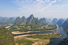
Kegelkarst is a type of tropical karst terrain with numerous cone-like hills, formed by cockpits, mogotes, and poljes and without strong fluvial erosion processes. This terrain is found in Cuba, Jamaica, Indonesia, Malaysia, the Philippines, Puerto Rico, southern China, Myanmar, Thailand, Laos and Vietnam.

Pseudokarst

Pseudokarsts are similar in form or appearance to karst features but are created by different mechanisms. Examples include lava caves and granite tors—for example, Labertouche Cave in Victoria, Australia—and paleocollapse features. Mud Caves are an example of pseudokarst.

Paleokarst

Paleokarst or palaeokarst is a development of karst observed in geological history and preserved within the rock sequence, effectively a fossil karst. There are for example palaeokarstic surfaces exposed within the Clydach Valley Subgroup of the Carboniferous Limestone sequence of South Wales which developed as sub-aerial weathering of recently formed limestones took place during periods of non-deposition within the early part of the period. Sedimentation resumed and further limestone strata were deposited on an irregular karstic surface, the cycle recurring several times in connection with fluctuating sea levels over prolonged periods.

Karst areas


The world's largest limestone karst is Australia's Nullarbor Plain. Slovenia has the world's highest risk of sinkholes, while the western Highland Rim in the eastern United States is at the second-highest risk of karst sinkholes.

Mexico hosts important karstic regions in the Yucatán Peninsula and Chiapas.
 
The South China Karst in the provinces of Guizhou, Guangxi, and Yunnan provinces is a UNESCO World Heritage Site.

The Tham Luang Nang Non karstic cave system in northern Thailand was made famous by the 2018 rescue of a junior football team.

List of terms for karst-related features

  • Abîme, a vertical shaft in karst that may be very deep and usually opens into a network of subterranean passages
  • Cenote, a deep sinkhole, characteristic of Mexico, resulting from collapse of limestone bedrock that exposes groundwater underneath
  • Doline, also sink or sinkhole, is a closed depression draining underground in karst areas. The name "doline" comes from dolina, meaning "valley", and derives from South Slavic languages.
  • Foibe, an inverted funnel-shaped sinkhole
  • Karst fenster ("karst window"), a feature where a spring emerges briefly, with the water discharge then abruptly disappearing into a nearby sinkhole
  • Karst spring, a spring emerging from karst, originating a flow of water on the surface
  • Limestone pavement, a landform consisting of a flat, incised surface of exposed limestone that resembles an artificial pavement
  • Losing stream, sinking river or ponornica in South Slavic languages.
  • Polje (karst polje, karst field), a large flat specifically karstic plain. The name "polje" derives from South Slavic languages.
  • Ponor, same as estavelle, sink or sinkhole in South Slavic languages, where surface flow enters an underground system
  • Scowle, porous irregular karstic landscape in a region of England.
  • Turlough (turlach), a type of disappearing lake characteristic of Irish karst.
  • Uvala, a collection of multiple smaller individual sinkholes that coalesce into a compound sinkhole. The term derives from South Slavic languages (many karst-related terms derive from South Slavic languages, entering scientific vocabulary through early research in the Western Balkan Dinaric Alpine karst).

Stone Forest

From Wikipedia, the free encyclopedia
 
Main entrance to the Shilin Stone Forest

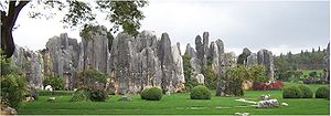
The Stone Forest or Shilin (Chinese: ; pinyin: Shílín) is a notable set of limestone formations about 500 km2 located in Shilin Yi Autonomous County, Yunnan Province, People's Republic of China, near Shilin approximately 90 km (56 mi) from the provincial capital Kunming.

The tall rocks seem to arise from the ground in a manner somewhat reminiscent of stalagmites, or with many looking like petrified trees, thereby creating the illusion of a forest made of stone. Since 2007, two parts of the site, the Naigu Stone Forest (乃古石林) and Suogeyi Village (所各邑村), have been UNESCO World Heritage Sites as part of the South China Karst. The site is classified as a AAAAA-class tourist site.

Features

Shilin
 
Shilin National Scenic Area (昆明市石林风景区) covers an area of 400 km2 (150 sq mi) and is divided into seven scenic areas as follows:
  • Greater & Lesser Stone Forests (大小石林) - also known as the Lizijing Stone Forest (李子菁石林)
  • Naigu Stone Forest (乃古石林)
  • Zhiyun Cave (芝云洞)
  • Lake Chang (长湖 literally Long Lake)
  • Lake Yue (月湖 literally Moon Lake)
  • Dadieshui Waterfall (大叠水瀑布)
  • Qifeng Cave (奇峰洞)
These formations, caused by the erosion of limestone, are believed to be over 270 million years old and are a tourist attraction for both overseas and domestic tourists, with bus tours bringing tourists from Kunming. There are also a number of hotels in the area.

Culture

According to legend, the forest is the birthplace of Ashima (阿诗玛), a beautiful girl of the Yi people. After falling in love she was forbidden to marry her chosen suitor and instead turned into a stone in the forest that still bears her name. Each year on the 24th day of the sixth lunar month, many Yi people celebrate the Torch Festival (火把节 Huǒbă Jié), which features folk dances and wrestling competitions.

Transportation

There are buses available from Kunming East Bus Station to the scenic site of Stone Forest, taking about 1.5 hours to get there. Trains are also available from Kunming Train Station to Shilin Train Station, about 2 hours' train ride or 20 minutes by high speed train.

Geology

The Stone Forest area was a shallow sea some 270 million years ago. Extensive deposits of sandstone overlain by limestone accumulated in this basin during the Permian period of geologic time. Uplift of this region occurred subsequent to deposition. Later, exposure to wind and running water shaped these limestone pillars. These formations extend as far as the eye can see, looking like a vast forest of stone, hence the name "The Stone Forest". The Major and Minor Stone Forests are developed in the nearly pure limestone of the Permian Makou Formation. The Naigu Stone Forest, 9 km northeast of the Major Stone Forest, is developed in dolomite and dolomitic limestone of the Permian Qixia Formation. Both formations are of Lower Permian age. They aggregate 505m in thickness and consist of shallow water (platform) massive limestone and dolomite, bio-clastic limestone, calcarenite and calcilutite. The Maokou Formation at Stone Forest appears to have been heavily altered diagenetically, and macroscopic fossil remains are seldom seen. Under the microscope, single whole or fractured fusulinid foraminifera are seen, commonly in biomicrite, biopelmicrite to biopelmicrosparite limestones. At least one zone of chert nodules occurs in the limestone, Unlike in the dolomitic Qixia Formation, dolomite in the Maokou Formation seldom ranges above 3%.

The strata are part of a gentle (2-6 degrees) westward dipping monocline. Conjugate shear joints (NE-SW and NE-SE) are well developed and these fractures provided the main passageways for surface water and underground water in the pre-karst development stage. The distribution, density and orientation of the fractures controlled the depth, size and orientation of the karst topography. Sandstones and shales of the Liangshan Formation that lies below the carbonate rock formations serve as a permeability barrier and force the local groundwater to flow from west to east.

Flora

The Shilin Karst area has the following types of forests and plant communities.

Other plant species

Representation of a Lie group

From Wikipedia, the free encyclopedia https://en.wikipedia.org/wiki/Representation_of_a_Lie_group...