Search This Blog

Saturday, August 8, 2020

Hawaiian Islands

From Wikipedia, the free encyclopedia

Hawaiian Islands
Native name:
Mokupuni o Hawai‘i
Hawaje-NoRedLine.jpg
The Windward Islands of Hawaii
Hawaiianislandchain USGS.png
Geography
LocationNorth Pacific Ocean
Total islands137
Highest point
Administration
United States
StateHawaii
Unincorporated territoryMidway Atoll
Largest settlementHonolulu

The Hawaiian Islands (Hawaiian: Mokupuni o Hawai‘i) are an archipelago of eight major islands, several atolls, numerous smaller islets, and seamounts in the North Pacific Ocean, extending some 1,500 miles (2,400 kilometers) from the island of Hawaiʻi in the south to northernmost Kure Atoll. Formerly the group was known to Europeans and Americans as the Sandwich Islands, a name that James Cook chose in honor of the then First Lord of the Admiralty John Montagu, 4th Earl of Sandwich. The contemporary name, dating from the 1840s, is derived from the name of the largest island, Hawaiʻi Island. The islands were first known to Europeans after the expedition of Álvaro de Saavedra Cerón in 1527.

Hawaii is the only U.S. state that is not geographically connected to North America. The state of Hawaii occupies the archipelago almost in its entirety (including the mostly uninhabited Northwestern Hawaiian Islands), with the sole exception of Midway Island, which also belongs to the United States, albeit as one of its unincorporated territories within the United States Minor Outlying Islands.

The Hawaiian Islands are the exposed peaks of a great undersea mountain range known as the Hawaiian–Emperor seamount chain, formed by volcanic activity over a hotspot in the Earth's mantle. The islands are about 1,860 miles (3,000 km) from the nearest continent.

Islands and reefs

The date of the first settlements of the Hawaiian Islands is a topic of continuing debate. Archaeological evidence seems to indicate a settlement as early as 124 AD.

Captain James Cook visited the islands on January 18, 1778, and named them the "Sandwich Islands" in honor of John Montagu, 4th Earl of Sandwich, who as the First Lord of the Admiralty was one of his sponsors. This name was in use until the 1840s, when the local name "Hawaii" gradually began to take precedence.

The Hawaiian Islands have a total land area of 6,423.4 square miles (16,636.5 km2). Except for Midway, which is an unincorporated territory of the United States, these islands and islets are administered as Hawaii—the 50th state of the United States.

Smaller islands, atolls, reefs

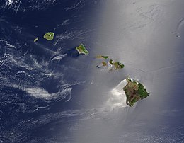
Hawaiian Islands from space.
 
Smaller islands, atolls, and reefs (all west of Niʻihau are uninhabited except Midway Atoll) form the Northwestern Hawaiian Islands, or Hawaiian Leeward Islands:

Islets

3-D perspective view of the southeastern Hawaiian Islands, with the white summits of Mauna Loa (4,170 m or 13,680 ft high) and Mauna Kea (4,206 m or 13,799 ft high). The islands are the tops of massive volcanoes, the bulk of which lie below the sea surface. Ocean depths are colored from violet (5,750 m or 18,860 ft deep northeast of Maui) and indigo to light gray (shallowest). Historical lava flows are shown in red, erupting from the summits and rift zones of Mauna Loa, Kilauea, and Hualalai volcanoes on Hawaiʻi.
 
The state of Hawaii counts 137 "islands" in the Hawaiian chain. This number includes all minor islands and islets (very small islands) offshore of the main islands (listed above) and individual islets in each atoll. These are just a few:
A composite satellite image from NASA of the Hawaiian Islands taken from outer space. Click on the image for a larger view that shows the main islands and the extended archipelago.

Geology

This chain of islands, or archipelago, developed as the Pacific Plate slowly moved northwestward over a hotspot in the Earth's mantle at a rate of approximately 32 miles (51 km) per million years. Thus, the southeast island is volcanically active, whereas the islands on the northwest end of the archipelago are older and typically smaller, due to longer exposure to erosion. The age of the archipelago has been estimated using potassium-argon dating methods. From this study and others, it is estimated that the northwesternmost island, Kure Atoll, is the oldest at approximately 28 million years (Ma); while the southeasternmost island, Hawaiʻi, is approximately 0.4 Ma (400,000 years). The only active volcanism in the last 200 years has been on the southeastern island, Hawaiʻi, and on the submerged but growing volcano to the extreme southeast, Loʻihi. The Hawaiian Volcano Observatory of the USGS documents recent volcanic activity and provides images and interpretations of the volcanism. Kīlauea had been erupting nearly continuously since 1983 when it stopped August 2018. 

Almost all of the magma of the hotspot has the composition of basalt, and so the Hawaiian volcanoes are composed almost entirely of this igneous rock. There is very little coarser-grained gabbro and diabase. Nephelinite is exposed on the islands but is extremely rare. The majority of eruptions in Hawaiʻi are Hawaiian-type eruptions because basaltic magma is relatively fluid compared with magmas typically involved in more explosive eruptions, such as the andesitic magmas that produce some of the spectacular and dangerous eruptions around the margins of the Pacific basin.

Eruptions from the Hawaii hotspot left a trail of underwater mountains across the Pacific over millions of years, called the Emperor Seamounts
 
Hawaiʻi island (the Big Island) is the biggest and youngest island in the chain, built from five volcanoes. Mauna Loa, taking up over half of the Big Island, is the largest shield volcano on the Earth. The measurement from sea level to summit is more than 2.5 miles (4 km), from sea level to sea floor about 3.1 miles (5 km).

Earthquakes

The Hawaiian Islands have many earthquakes, generally caused by volcanic activity. Most of the early earthquake monitoring took place in Hilo, by missionaries Titus Coan, Sarah J. Lyman and her family. Between 1833 and 1896, approximately 4 or 5 earthquakes were reported per year.

Hawaii accounted for 7.3% of the United States' reported earthquakes with a magnitude 3.5 or greater from 1974 to 2003, with a total 1533 earthquakes. Hawaii ranked as the state with the third most earthquakes over this time period, after Alaska and California.

On October 15, 2006, there was an earthquake with a magnitude of 6.7 off the northwest coast of the island of Hawaii, near the Kona area of the big island. The initial earthquake was followed approximately five minutes later by a magnitude 5.7 aftershock. Minor-to-moderate damage was reported on most of the Big Island. Several major roadways became impassable from rock slides, and effects were felt as far away as Honolulu, Oahu, nearly 150 miles (240 km) from the epicenter. Power outages lasted for several hours to days. Several water mains ruptured. No deaths or life-threatening injuries were reported.

On May 4, 2018 there was a 6.9 earthquake in the zone of volcanic activity from Kīlauea.

Earthquakes are monitored by the Hawaiian Volcano Observatory run by the USGS.

Tsunamis

Aftermath of the 1960 Chilean tsunami in Hilo, Hawaiʻi, where the tsunami left 61 people dead and 282 seriously injured. The waves reached 35 feet (11 m) high.
 
The Hawaiian Islands are subject to tsunamis, great waves that strike the shore. Tsunamis are most often caused by earthquakes somewhere in the Pacific. The waves produced by the earthquakes travel at speeds of 400–500 miles per hour (600–800 km/h) and can affect coastal regions thousands of miles (kilometers) away.

Tsunamis may also originate from the Hawaiian Islands. Explosive volcanic activity can cause tsunamis. The island of Molokaʻi had a catastrophic collapse or debris avalanche over a million years ago; this underwater landslide likely caused tsunamis. The Hilina Slump on the island of Hawaiʻi is another potential place for a large landslide and resulting tsunami.

The city of Hilo on the Big Island has been most affected by tsunamis, where the in-rushing water is accentuated by the shape of Hilo Bay. Coastal cities have tsunami warning sirens.

A tsunami resulting from an earthquake in Chile hit the islands on February 27, 2010. It was relatively minor, but local emergency management officials utilized the latest technology and ordered evacuations in preparation for a possible major event. The Governor declared it a "good drill" for the next major event.

A tsunami resulting from an earthquake in Japan hit the islands on March 11, 2011. It was relatively minor, but local officials ordered evacuations in preparation for a possible major event. The tsunami caused about $30.1 million in damages.

Ecology

The islands are home to a multitude of endemic species. Since human settlement, first by Polynesians, non native trees, plants, and animals were introduced. These included species such as rats and pigs, that have preyed on native birds and invertebrates that initially evolved in the absence of such predators. The growing population of humans has also led to deforestation, forest degradation, treeless grasslands, and environmental degradation. As a result, many species which depended on forest habitats and food became extinct—with many current species facing extinction. As humans cleared land for farming, monocultural crop production replaced multi-species systems.

The arrival of the Europeans had a more significant impact, with the promotion of large-scale single-species export agriculture and livestock grazing. This led to increased clearing of forests, and the development of towns, adding many more species to the list of extinct animals of the Hawaiian Islands. As of 2009, many of the remaining endemic species are considered endangered.

National Monument

On June 15, 2006, President George W. Bush issued a public proclamation creating Papahānaumokuākea Marine National Monument under the Antiquities Act of 1906. The Monument encompasses the northwestern Hawaiian Islands and surrounding waters, forming the largest marine wildlife reserve in the world. In August 2010, UNESCO's World Heritage Committee added Papahānaumokuākea to its list of World Heritage Sites. On August 26, 2016, President Barack Obama greatly expanded Papahānaumokuākea, quadrupling it from its original size.

Climate

The climate of the Hawaiian Islands is tropical but it experiences many different climates, depending on altitude and weather. The islands receive most rainfall from the trade winds on their north and east flanks (the windward side) as a result of orographic precipitation. Coastal areas in general and especially the south and west flanks or leeward sides, tend to be drier.

In general, the lowlands of Hawaiian Islands receive most of their precipitation during the winter months (October to April). Drier conditions generally prevail from May to September. The tropical storms, and occasional hurricanes, tend to occur from July through November.

During the summer months the average temperature is about 84 °F (29 °C), in the winter months it is approximately 78,8 °F (26°C). As the temperature is relatively constant over the year the probability of dangerous thunderstorms is approximately low.

Tibeto-Burman languages

From Wikipedia, the free encyclopedia
 
Tibeto-Burman
Geographic
distribution
Southeast Asia, East Asia, South Asia
Linguistic classificationSino-Tibetan
  • Tibeto-Burman
Proto-languageProto-Tibeto-Burman
Subdivisions
ISO 639-5tbq
GlottologNone
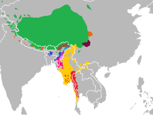
Lenguas tibeto-birmanas.png

The Tibeto-Burman languages are the non-Sinitic members of the Sino-Tibetan language family, over 400 of which are spoken throughout the highlands of Southeast Asia as well as certain parts of East Asia and South Asia. Around 60 million people speak Tibeto-Burman languages, around half of whom speak Burmese, and 13% of whom speak Tibetic languages. The name derives from the most widely spoken of these languages, namely Burmese (over 35 million speakers) and the Tibetic languages (over 8 million). These languages also have extensive literary traditions, dating from the 12th and 7th centuries respectively. Most of the other languages are spoken by much smaller communities, and many of them have not been described in detail.

Some taxonomies divide Sino-Tibetan into Sinitic and Tibeto-Burman branches (e.g. Benedict, Matisoff), but other scholars deny that Tibeto-Burman comprises a monophyletic group.

History

During the 18th century, several scholars noticed parallels between Tibetan and Burmese, both languages with extensive literary traditions. In the following century, Brian Houghton Hodgson collected a wealth of data on the non-literary languages of the Himalayas and northeast India, noting that many of these were related to Tibetan and Burmese. Others identified related languages in the highlands of Southeast Asia and south-west China. The name "Tibeto-Burman" was first applied to this group in 1856 by James Logan, who added Karen in 1858. Charles Forbes viewed the family as uniting the Gangetic and Lohitic branches of Max Müller's Turanian, a huge family consisting of all the Eurasian languages except the Semitic, "Aryan" (Indo-European) and Chinese languages. The third volume of the Linguistic Survey of India was devoted to the Tibeto-Burman languages of British India.

Julius Klaproth had noted in 1823 that Burmese, Tibetan and Chinese all shared common basic vocabulary, but that Thai, Mon and Vietnamese were quite different. Several authors, including Ernst Kuhn in 1883 and August Conrady in 1896, described an "Indo-Chinese" family consisting of two branches, Tibeto-Burman and Chinese-Siamese. The Tai languages were included on the basis of vocabulary and typological features shared with Chinese. Jean Przyluski introduced the term sino-tibétain (Sino-Tibetan) as the title of his chapter on the group in Antoine Meillet and Marcel Cohen's Les Langues du Monde in 1924.

The Tai languages have not been included in most Western accounts of Sino-Tibetan since the Second World War, though many Chinese linguists still include them. The link between Tibeto-Burman and Chinese is now accepted by most linguists, with a few exceptions such as Roy Andrew Miller and Christopher Beckwith. More recent controversy has centred on the proposed primary branching of Sino-Tibetan into Chinese and Tibeto-Burman subgroups. In spite of the popularity of this classification, first proposed by Kuhn and Conrady, and also promoted by Paul Benedict (1972) and later James Matisoff, Tibeto-Burman has not been demonstrated to be a valid family in its own right.

Overview

Most of the Tibeto-Burman languages are spoken in remote mountain areas, which has hampered their study. Many lack a written standard. It is generally easier to identify a language as Tibeto-Burman than to determine its precise relationship with other languages of the group. The subgroupings that have been established with certainty number several dozens, ranging from well-studied groups of dozens of languages with millions of speakers to several isolates, some only newly discovered but in danger of extinction. These subgroups are here surveyed on a geographical basis.

Southeast Asia and southwest China

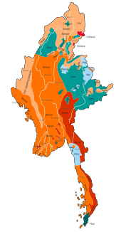
Language families of Myanmar

The southernmost group is the Karen languages, spoken by three million people on both sides of the Burma–Thailand border. They differ from all other Tibeto-Burman languages (except Bai) in having a subject–verb–object word order, attributed to contact with Tai–Kadai and Austroasiatic languages.

The most widely spoken Tibeto-Burman language is Burmese, the national language of Myanmar, with over 32 million speakers and a literary tradition dating from the early 12th century. It is one of the Lolo-Burmese languages, an intensively studied and well-defined group comprising approximately 100 languages spoken in Myanmar and the highlands of Thailand, Laos, Vietnam, and Southwest China. Major languages include the Loloish languages, with two million speakers in western Sichuan and northern Yunnan, the Akha language and Hani languages, with two million speakers in southern Yunnan, eastern Myanmar, Laos and Vietnam, and Lisu and Lahu in Yunnan, northern Myanmar and northern Thailand. All languages of the Loloish subgroup show significant Austroasiatic influence. The Pai-lang songs, transcribed in Chinese characters in the 1st century, appear to record words from a Lolo-Burmese language, but arranged in Chinese order.

Language families of China, with Tibeto-Burman in orange
 
The Tibeto-Burman languages of south-west China have been heavily influenced by Chinese over a long period, leaving their affiliations difficult to determine. The grouping of the Bai language, with one million speakers in Yunnan, is particularly controversial, with some workers suggesting that it is a sister language to Chinese. The Naxi language of northern Yunnan is usually included in Lolo-Burmese, though other scholars prefer to leave it unclassified. The hills of northwestern Sichuan are home to the small Qiangic and Rgyalrongic groups of languages, which preserve many archaic features. The most easterly Tibeto-Burman language is Tujia, spoken in the Wuling Mountains on the borders of Hunan, Hubei, Guizhou and Chongqing.

Two historical languages are believed to be Tibeto-Burman, but their precise affiliation is uncertain. The Pyu language of central Myanmar in the first centuries is known from inscriptions using a variant of the Gupta script. The Tangut language of the 12th century Western Xia of northern China is preserved in numerous texts written in the Chinese-inspired Tangut script.

Tibet and South Asia

Language families of South Asia, with Tibeto-Burman in orange

Over eight million people in the Tibetan Plateau and neighbouring areas in Baltistan, Ladakh, Nepal, Sikkim and Bhutan speak one of several related Tibetic languages. There is an extensive literature in Classical Tibetan dating from the 8th century. The Tibetic languages are usually grouped with the smaller East Bodish languages of Bhutan and Arunachal Pradesh as the Bodish group.

Many diverse Tibeto-Burman languages are spoken on the southern slopes of the Himalayas. Sizable groups that have been identified are the West Himalayish languages of Himachal Pradesh and western Nepal, the Tamangic languages of western Nepal, including Tamang with one million speakers, and the Kiranti languages of eastern Nepal. The remaining groups are small, with several isolates. The Newar language (Nepal Bhasa) of central Nepal has a million speakers and literature dating from the 12th century, and nearly a million people speak Magaric languages, but the rest have small speech communities. Other isolates and small groups in Nepal are Dura, Raji–Raute, Chepangic and Dhimalish. Lepcha is spoken in an area from eastern Nepal to western Bhutan. Most of the languages of Bhutan are Bodish, but it also has three small isolates, 'Ole ("Black Mountain Monpa"), Lhokpu and Gongduk and a larger community of speakers of Tshangla.

The Tani languages include most of the Tibeto-Burman languages of Arunachal Pradesh and adjacent areas of Tibet. The remaining languages of Arunachal Pradesh are much more diverse, belonging to the small Siangic, Kho-Bwa (or Kamengic), Hruso, Miju and Digaro languages (or Mishmic) groups. These groups have relatively little Tibeto-Burman vocabulary, and Bench and Post dispute their inclusion in Sino-Tibetan.

Northeastern states of India (most of Arunachal Pradesh and the northern part of Assam are also claimed by China)
 
The greatest variety of languages and subgroups is found in the highlands stretching from northern Myanmar to northeast India.

Northern Myanmar is home to the small Nungish group, as well as the Jingpho–Luish languages, including Jingpho with nearly a million speakers. The Brahmaputran or Sal languages include at least the Bodo–Garo and Konyak languages, spoken in an area stretching from northern Myanmar through the Indian states of Nagaland, Meghalaya, and Tripura, and are often considered to include the Jingpho–Luish group.

The border highlands of Nagaland, Manipur and western Myanmar are home to the small Ao, Angami–Pochuri, Tangkhulic, and Zeme groups of languages, as well as the Karbi language. Meithei, the main language of Manipur with 1.4 million speakers, is sometimes linked with the 50 or so Kuki-Chin languages are spoken in Mizoram and the Chin State of Myanmar.

The Mru language is spoken by a small group in the Chittagong Hill Tracts between Bangladesh and Myanmar.

Classification

There have been two milestones in the classification of Sino-Tibetan and Tibeto-Burman languages, Shafer (1955) and Benedict (1972), which were actually produced in the 1930s and 1940s respectively.

Shafer (1955)

Shafer's tentative classification took an agnostic position and did not recognize Tibeto-Burman, but placed Chinese (Sinitic) on the same level as the other branches of a Sino-Tibetan family. He retained Tai–Kadai (Daic) within the family, allegedly at the insistence of colleagues, despite his personal belief that they were not related.
Sino-Tibetan
I. Sinitic
II. ?? Daic
III. Bodic
a. Bodish (Gurung, Tshangla, Gyarong, Tibetic)
b. West Himalayish (incl. Thangmi, Baram, Raji–Raute)
c. West Central Himalayish (Magar, Chepang, Hayu [misplaced])
d. East Himalayish
e. Newarish
f. Digarish
g. Midźuish
h. Hruish
i. Dhimalish
j. Miśingish
k. Dzorgaish
IV. Burmic
a. Burmish
b. Mruish
c. Nungish
d. Katśinish (Jingpho)
e. Tśairelish
f. Luish
g. Taman
h. Kukish
V. Baric
a. Barish
b. Nagish
VI. Karenic

Benedict (1972)

A very influential, although also tentative, classification is that of Benedict (1972), which was actually written around 1941. Like Shafer's work, this drew on the data assembled by the Sino-Tibetan Philology Project, which was directed by Shafer and Benedict in turn. Benedict envisaged Chinese as the first family to branch off, followed by Karen.
Sino-Tibetan
  1. Chinese
  2. Tibeto-Karen
    • Karen
    • Tibeto-Burman
The Tibeto-Burman family is then divided into seven primary branches:
I. Tibetan–Kanauri (a.k.a. Bodish–Himalayish)
A. Bodish
(Tibetic, Gyarung, Takpa, Tsangla, Murmi & Gurung)
B. Himalayish
i. "major" Himalayish
ii. "minor" Himalayish
(Rangkas, Darmiya, Chaudangsi, Byangsi)
(perhaps also Dzorgai, Lepcha, Magari)
A. Bahing (Sunuwar, Khaling)
B. Khambu (Sampang, Rungchenbung, Yakha, and Limbu)
C. VayuChepang
(perhaps also Newar)
(perhaps also Aka, Digaro, Miju, and Dhimal)
IV. Kachin
(perhaps including Luish)
A. Burmese–Maru
B. Southern Lolo
C. Northern Lolo
D. Kanburi Lawa
E. Moso
F. Hsi-fan (Qiangic and Jiarongic languages apart from Qiang and Gyarung themselves)
G. Tangut
(perhaps also Nung)
VI. Bodo-Garo
A. Bodo
B. Garo (A·chik)
C. Borok (Tripuri (Tøipra))
D. Dimasa
E. Mech
F. Rava (Koch)
G. Tiwa (Lalung)
H. Sutiya
I. Saraniya
J. Sonowal
(Perhaps also "Naked Naga" a.k.a. Konyak)
VII. Kuki–Naga (a.k.a. Kukish)
(perhaps also Karbi, Meithei, Mru)

Matisoff (1978)

James Matisoff proposes a modification of Benedict that demoted Karen but kept the divergent position of Sinitic. Of the 7 branches within Tibeto-Burman, 2 branches (Baic and Karenic) have SVO-order languages, whereas all the other 5 branches have SOV-order languages.
Sino-Tibetan
  1. Chinese
  2. Tibeto-Burman
Tibeto-Burman is then divided into several branches, some of them geographic conveniences rather than linguistic proposals:
Matisoff makes no claim that the families in the Kamarupan or Himalayish branches have a special relationship to one another other than a geographic one. They are intended rather as categories of convenience pending more detailed comparative work.

Matisoff also notes that Jingpho–Nungish–Luish is central to the family in that it contains features of many of the other branches, and is also located around the center of the Tibeto-Burman-speaking area.

Bradley (2002)

Since Benedict (1972), many languages previously inadequately documented have received more attention with the publication of new grammars, dictionaries, and wordlists. This new research has greatly benefited comparative work, and Bradley (2002) incorporates much of the newer data.

I. Western (= Bodic)
A. Tibetan–Kanauri
i. Tibetic
ii. Gurung
iii. East Bodic (incl. Tsangla)
iv. Kanauri
B. Himalayan
i. Eastern (Kiranti)
ii. Western (Newar, Chepang, Magar, Thangmi, Baram)
II. Sal
A. Baric (Bodo–GaroNorthern Naga)
B. Jinghpaw
C. Luish (incl. Pyu)
D. Kuki-Chin (incl. Meithei and Karbi)
III. Central (perhaps a residual group, not actually related to each other. Lepcha may also fit here.)
A. Adi–Galo–Mishing–Nishi
B. Mishmi (Digarish and Keman)
C. Rawang
IV. North-Eastern
A. Qiangic
B. NaxiBai
C. Tujia
D. Tangut
V. South-Eastern
A. Burmese–Lolo (incl. Mru)
B. Karen

van Driem

George van Driem rejects the primary split of Sinitic, making Tibeto-Burman synonymous with Sino-Tibetan.

Matisoff (2015)

The internal structure of Tibeto-Burman is tentatively classified as follows by Matisoff (2015: xxxii, 1123-1127) in the final release of the Sino-Tibetan Etymological Dictionary and Thesaurus (STEDT).

Other languages

The classification of Tujia is difficult due to extensive borrowing. Other unclassified Tibeto-Burman languages include Basum and the recently described Lamo language. New Tibeto-Burman languages continue to be recognized, some not closely related to other languages. Recently recognized distinct languages include Koki Naga.

Randy LaPolla (2003) proposed a Rung branch of Tibeto-Burman, based on morphological evidence, but this is not widely accepted.

Scott DeLancey (2015) proposed a Central branch of Tibeto-Burman based on morphological evidence. 

Roger Blench and Mark Post (2011) list a number of divergent languages of Arunachal Pradesh, in northeastern India, that might have non-Tibeto-Burman substrates, or could even be non-Tibeto-Burman language isolates:
Blench and Post believe the remaining languages with these substratal characteristics are more clearly Sino-Tibetan:

Philosophy of self

From Wikipedia, the free encyclopedia https://en.wikipedia.org/wiki/Philosophy_of_self The philosophy of self ...