Search This Blog

Wednesday, January 24, 2024

Mount Vesuvius

From Wikipedia, the free encyclopedia
 
Mount Vesuvius
Mount Vesuvius
Highest point
Elevation1,281 m (4,203 ft) 
Prominence1,232 m (4,042 ft) 
Coordinates40°49′N 14°26′E
Naming
Native name
Geography
Mount Vesuvius is located in Italy
LocationCampania, Italy
Geology
Age of rock25,000 years before present to 1944; age of volcano = c. 17,000 years to present
Mountain typeSomma-stratovolcano
Volcanic arc/beltCampanian volcanic arc
Last eruption17–23 March 1944

Mount Vesuvius (/vɪˈsviəs/ viss-OO-vee-əs) is a somma-stratovolcano located on the Gulf of Naples in Campania, Italy, about 9 km (5.6 mi) east of Naples and a short distance from the shore. It is one of several volcanoes forming the Campanian volcanic arc. Vesuvius consists of a large cone partially encircled by the steep rim of a summit caldera, resulting from the collapse of an earlier, much higher structure.

The eruption of Mount Vesuvius in 79 AD destroyed the Roman cities of Pompeii, Herculaneum, Oplontis, Stabiae, and several other settlements. The eruption ejected a cloud of stones, ashes and volcanic gases to a height of 33 km (21 mi), erupting molten rock and pulverized pumice at the rate of 6×10⁵ cubic metres (7.8×10⁵ cu yd) per second. More than 1,000 people are thought to have died in the eruption, though the exact toll is unknown. The only surviving eyewitness account of the event consists of two letters by Pliny the Younger to the historian Tacitus.

Vesuvius has erupted many times since. It is the only volcano on Europe's mainland to have erupted in the last hundred years. It is regarded as one of the most dangerous volcanoes in the world because 3,000,000 people live near enough to be affected by an eruption, with at least 600,000 in the danger zone. This is the most densely populated volcanic region in the world. Eruptions tend to be violent and explosive; these are known as Plinian eruptions.

Mythology

Vesuvius has a long historic and literary tradition. It was considered a divinity of the Genius type at the time of the eruption of AD 79: it appears under the inscribed name Vesuvius as a serpent in the decorative frescos of many lararia, or household shrines, surviving from Pompeii. An inscription from Capua to IOVI VESVVIO indicates that he was worshipped as a power of Jupiter; that is, Jupiter Vesuvius.

The Romans regarded Mount Vesuvius as being devoted to Hercules. The historian Diodorus Siculus relates a tradition that Hercules, in the performance of his labors, passed through the country of nearby Cumae on his way to Sicily and found there a place called "the Phlegraean Plain" (Φλεγραῖον πεδίον, "plain of fire"), "from a hill which anciently vomited out fire ... now called Vesuvius." It was inhabited by giant bandits, "the sons of the Earth. With the gods' assistance, he pacified the region and continued. The facts behind the tradition, if any, remain unknown, as does whether Herculaneum was named after it. An epigram by the poet Martial in 88 AD suggests that both Venus, patroness of Pompeii, and Hercules were worshipped in the region devastated by the eruption of 79.

City of Naples with Mount Vesuvius

Etymology

Vesuvius was a name of the volcano in frequent use by the authors of the late Roman Republic and the early Roman Empire. Its collateral forms were Vesaevus, Vesevus, Vesbius and Vesvius. Writers in ancient Greek used Οὐεσούιον or Οὐεσούιος. Many scholars since then have offered an etymology. Given that peoples of varying ethnicity and language occupied Campania during the Roman Iron Age, the etymology depends to a large degree on the presumption of what language was spoken there at the time. Naples was settled by Greeks, as the name Nea-polis, "New City", testifies. The Oscans, an Italic people, lived in the countryside. The Latins also competed for the occupation of Campania. Etruscan settlements were in the vicinity. Other peoples of unknown provenance are said to have been there at some time by various ancient authors.

Some theories about its origin are:

  • From Greek οὔ = "not" prefixed to a root from or related to the Greek word σβέννυμι = "I quench", in the sense of "unquenchable".
  • From Greek ἕω = "I hurl" and βίη "violence", "hurling violence", *vesbia, taking advantage of the collateral form.
  • From an Indo-European root, *eus- < *ewes- < *h₁ews-, "shine", "burn", sense "the one who lightens", through Latin or Oscan.
  • From an Indo-European root *wes = "hearth" (compare e.g. Vesta)

Topography

The main cone of Vesuvius and the cliff of Monte Somma's caldera separated by the valley of Atrio di Cavallo

Vesuvius is a "humpbacked" peak, consisting of a large cone (Gran Cono) partially encircled by the steep rim of a summit caldera caused by the collapse of an earlier (and originally much higher) structure called Mount Somma. The Gran Cono was produced during the A.D. 79 eruption. For this reason, the volcano is also called Somma-Vesuvius or Somma-Vesuvio.

The caldera started forming during an eruption around 17,000–18,000 years ago and was enlarged by later paroxysmal eruptions, ending in the one of AD 79. This structure has given its name to the term "somma volcano", which describes any volcano with a summit caldera surrounding a newer cone.

The cliffs forming the northern ridge of Monte Somma's caldera rim reach a maximum height of 1,132 m (3,714 ft) at Punta Nasone. The summit of the main cone of Vesuvius is 1,281 m (4,203 ft) above sea level and more than 400 m (1,300 ft) above the 5 km (3.1 mi) long valley of Atrio di Cavallo (the northern floor of Monte Somma's caldera).

The volcano's slopes are scarred by lava flows, while the rest are heavily vegetated, with scrub and forests at higher altitudes and vineyards lower down.

Formation

Famous view of Vesuvius and the historic Pine of Naples overlooking the city of Naples in the 19th century, by Giorgio Sommer

Vesuvius is a stratovolcano and was formed as a result of the collision of two tectonic plates, the African and the Eurasian. The former was subducted at a convergent boundary beneath the latter, deeper into the earth. As the water-saturated sediments of the African oceanic plate were pushed to hotter depths inside the planet, the water boiled off and lowered the melting point of the upper mantle enough to partially melt the rocks. Because magma is less dense than the solid rock around it, it was pushed upward. Finding a weak spot at the Earth's surface, it broke through, thus forming the volcano.

The volcano is one of several forming the Campanian volcanic arc. Others include Campi Flegrei, a large caldera a few kilometers to the north-west, Ischia, a volcanic island 20 kilometres (12 mi) to the west, and several undersea volcanoes to the south. The arc forms the southern end of a larger chain of volcanoes produced by the subduction process described above, which extends northwest along the length of Italy as far as Monte Amiata in Southern Tuscany. Vesuvius is the only one to have erupted in recent history, although some of the others have erupted within the last few hundred years. Many are either extinct or have not erupted for tens of thousands of years.

Eruptions

Procession of Saint Januarius during an eruption of Vesuvius in 1822

Mount Vesuvius has erupted many times. Numerous others preceded the eruption in AD 79 in prehistory, including at least three significantly larger; an example is the Avellino eruption around 1800 BC, which engulfed several Bronze Age settlements. Since AD 79, the volcano has also erupted repeatedly, in 172, 203, 222, possibly in 303, 379, 472, 512, 536, 685, 787, around 860, around 900, 968, 991, 999, 1006, 1037, 1049, around 1073, 1139, 1150, and there may have been eruptions in 1270, 1347, and 1500. The volcano erupted again in 1631, six times in the 18th century (including 1779 and 1794), eight times in the 19th century (notably in 1872), and in 1906, 1929 and 1944. There have been no eruptions since 1944, and none of the eruptions after AD 79 were as large or destructive as the Pompeian one.

The eruptions vary greatly in severity but are characterized by explosive outbursts of the kind dubbed Plinian after Pliny the Younger, a Roman writer who published a detailed description of the AD 79 eruption, including his uncle's death. On occasion, eruptions from Vesuvius have been so large that the whole of southern Europe has been blanketed by ash; in 472 and 1631, Vesuvian ash fell on Constantinople (Istanbul), over 1,200 kilometres (750 mi) away. A few times since 1944, landslides in the crater have raised clouds of ash dust, raising false alarms of an eruption.

Since 1750, seven of the eruptions of Vesuvius have had durations of more than five years; only Mount Etna has had as many long-duration eruptions in the last 270 years. The two most recent eruptions of Vesuvius (1875–1906 and 1913–1944) each lasted more than 30 years.

Vesuvius is still regarded as an active volcano, although its current activity produces little more than sulfur-rich steam from vents at the bottom and walls of the crater.

Layers of lava, ash, scoria and pumice make up the volcanic peak. Their mineralogy is variable, but generally silica-undersaturated and rich in potassium, with phonolite produced in the more explosive eruptions (e.g. the eruption in 1631 displaying a complete stratigraphic and petrographic description: phonolite was firstly erupted, followed by a tephritic phonolite and finally a phonolitic tephrite).

Volcanic explosivity index

According to the Smithsonian Institution's Global Volcanism Program, Vesuvius has had 54 confirmed eruptions during the Holocene Epoch (the last 11,700 years). A volcanic explosivity index (VEI) has been assigned to all but one of these eruptions.

Volcanic explosivity index for Vesuvius
VEI Number of Holocene eruptions for which a VEI has been assigned (total=53)
VEI 0
2
VEI 1
2
VEI 2
7
VEI 3
29
VEI 4
8
VEI 5
5

Before AD 79

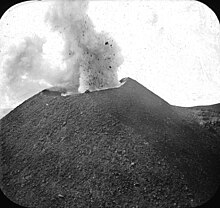
Vesuvius erupting (before 1923)

Scientific knowledge of the geologic history of Vesuvius comes from core samples taken from a 2,000 m (6,600 ft) plus borehole on the flanks of the volcano, extending into Mesozoic rock. Cores were dated by potassium–argon and argon–argon dating. The area has been subject to volcanic activity for at least 400,000 years; the lowest layer of eruption material from the Somma caldera lies on top of the 40,000-year‑old Campanian ignimbrite produced by the Campi Flegrei complex. The volcanic complex stands on a large, sedimentary plain.

  • 25,000 years ago: Vesuvius started forming in the Codola Plinian eruption.
  • Vesuvius was then built up by a series of lava flows, with some smaller explosive eruptions interspersed between them. By this time, the volcano was 2,000 meters (6,560 feet) tall, with the summit being 500 meters (1,640 feet) east of the current summit.
  • About 19,000 years ago: the style of eruption changed to a sequence of large explosive and caldera-forming Plinian eruptions, of which the AD 79 one was the most recent. The calderas are aligned in a roughly east-west direction, and all contributed to forming present-day's Somma caldera. The eruptions are named after the tephra deposits produced by them, which in turn are named after the place where the deposits were first identified:
  • 18,300 years ago: the Basal Pumice (Pomici di Base) eruption, VEI 6, the original formation of the Somma caldera. The caldera's formation was asymmetric towards the west. The eruption was followed by a period of much less violent, lava-producing eruptions.
  • 16,000 years ago: the Green Pumice (Pomici Verdoline) eruption, VEI 5.
  • Around 11,000 years ago: the Lagno Amendolare eruption, smaller than the Mercato eruption.
  • 8,000 years ago: the Mercato eruption (Pomici di Mercato) – also known as Pomici Gemelle or Pomici Ottaviano, VEI 6.
  • Around 5,000 years ago: two explosive eruptions smaller than the Avellino eruption.
  • 3,800 years ago (19th century BC): the Avellino eruption (Pomici di Avellino), VEI 6; its vent was apparently 2 km (1.2 mi) west of the current crater and the eruption destroyed several Bronze Age settlements of the Apennine culture, including ancient Afragola. Several carbon dates on wood and bones offer a range of possible dates of about 500 years in the mid-2nd millennium BC. In May 2001, near Nola, Italian archaeologists using the technique of filling every cavity with plaster or substitute compound, recovered some remarkably well-preserved forms of perishable objects, such as fence rails, a bucket and especially in the vicinity, thousands of human footprints pointing into the Apennines to the north. The settlement had huts, pots and goats. The residents had hastily abandoned the village, leaving it to be buried under pumice and ash in much the same way that Pompeii and Herculaneum were later preserved. Pyroclastic surge deposits were distributed to the northwest of the vent, travelling as far as 15 km (9.3 mi) from it, and lie up to 3 m (9.8 ft) deep in the area now occupied by Naples.
  • The volcano then entered a stage of more frequent, but less violent eruptions, until the most recent Plinian eruption, which destroyed Pompeii and Herculaneum. Evidence of these eruptions comes from badly preserved ashfall deposits that have been dubitatively assigned to Either the Somma-Vesuvius complex, or the Phlegrean fields.
  • The last of these may have been in 217 BC. There were earthquakes in Italy during that year and the sun was reported as being dimmed by gray haze or dry fog. Plutarch wrote of the sky being on fire near Naples, and Silius Italicus mentioned in his epic poem Punica that Vesuvius had thundered and produced flames worthy of Mount Etna in that year. However, both authors were writing around 250 years later. Greenland ice core samples of around that period show relatively high acidity, which is assumed to have been caused by atmospheric hydrogen sulfide.
Fresco of Bacchus and Agathodaemon with Mount Vesuvius, as seen in Pompeii's House of the Centenary
  • The volcano was then quiet (for 295 years, if the 217 BC date for the last previous eruption is true) and was described by Roman writers as having been covered with gardens and vineyards, except at the top, which was craggy. The volcano may have had only one summit at that time, judging by a wall painting, "Bacchus and Vesuvius", found in a Pompeian house, the House of the Centenary (Casa del Centenario).

Several surviving works written over the 200 years preceding the AD 79 eruption describe the mountain as having had a volcanic nature, although Pliny the Elder did not depict the mountain in this way in his Natural History:

  • The Greek historian Strabo (c. 63 BC – c. 24 AD) described the mountain in Book V, Chapter 4 of his Geographica as having a predominantly flat, barren summit covered with sooty, ash-coloured rocks, and suggested that it might once have had "craters of fire". He also perceptively suggested that the fertility of the surrounding slopes may be due to volcanic activity, as at Mount Etna.
  • In Book II of De architectura, the architect Vitruvius (c. 80–70 BC –?) reported that fires had once existed abundantly below the peak and that it had spouted fire onto the surrounding fields. He described Pompeiian pumice as having been burnt from another species of stone.
  • Diodorus Siculus (c. 90 BC – c. 30 BC), another Greek writer, wrote in Book IV of his Bibliotheca Historica that the Campanian plain was called fiery (Phlegrean) because of the peak, Vesuvius, which had spouted flames like Etna and showed signs of the fire that had burnt in ancient history.

Eruption of AD 79

In AD 79, Vesuvius erupted in one of the most catastrophic eruptions of all time. Historians have learned about the eruption from the eyewitness account of Pliny the Younger, a Roman administrator and poet. Several dates are given in the surviving copies of the letters. The latest evidence supports earlier findings and indicates that the eruption occurred after 17 October.

The volcano ejected a cloud of stones, ashes and volcanic gases to a height of 33 km (21 mi), spewing molten rock and pulverized pumice at the rate of 6×10⁵ cubic metres (7.8×10⁵ cu yd) per second, ultimately releasing 100,000 times the thermal energy released by the Hiroshima-Nagasaki bombings. The cities of Pompeii and Herculaneum were destroyed by pyroclastic surges and the ruins buried under tens of metres of tephra.

Precursors and foreshocks

The AD 79 eruption was preceded by a powerful earthquake in 62, which caused widespread destruction around the Bay of Naples, and particularly to Pompeii. Some of the damage had still not been repaired when the volcano erupted. The deaths of 600 sheep from "tainted air" in the vicinity of Pompeii indicates that the earthquake of AD 62 may have been related to new activity by Vesuvius.

The Romans grew accustomed to minor earth tremors in the region; the writer Pliny the Younger even wrote that they "were not particularly alarming because they are frequent in Campania". Small earthquakes started taking place four days before the eruption becoming more frequent over the next four days, but the warnings were not recognized.

Scientific analysis

Pompeii and Herculaneum, as well as other cities affected by the eruption of Mount Vesuvius. The black cloud represents the general distribution of ash, pumice and cinders. Modern coast lines are shown.

Reconstructions of the eruption and its effects vary considerably in the details but have the same overall features. The eruption lasted two days. The morning of the first day was perceived as normal by the only eyewitness to leave a surviving document, Pliny the Younger. In the middle of the day, an explosion threw up a high-altitude column from which ash and pumice began to fall, blanketing the area. Rescues and escapes occurred during this time. At some time in the night or early the next day, pyroclastic surges in the close vicinity of the volcano began. Lights were seen on the peak, interpreted as fires. People as far away as Misenum fled for their lives. The flows were rapid-moving, dense and very hot, knocking down, wholly or partly, all structures in their path, incinerating or suffocating all population remaining there and altering the landscape, including the coastline. Additional light tremors accompanied these and a mild tsunami in the Bay of Naples. By late afternoon of the second day, the eruption was over, leaving only haze in the atmosphere through which the sun shone weakly.

The latest scientific studies of the ash produced by Vesuvius reveal a multi-phase eruption. The initial major explosion produced a column of ash and pumice ranging between 15 and 30 kilometres (49,000 and 98,000 ft) high, which rained on Pompeii to the southeast but not on Herculaneum upwind. The chief energy supporting the column came from the escape of steam superheated by the magma, created from seawater seeping over time into the deep faults of the region, which interacted with magma.

Subsequently, the cloud collapsed as the gases expanded and lost their capability to support their solid contents, releasing it as a pyroclastic surge, which first reached Herculaneum but not Pompeii. Additional blasts reinstituted the column. The eruption alternated between Plinian and Peléan six times. Surges 3 and 4 are believed by the authors to have buried Pompeii. Surges are identified in the deposits by dune and cross-bedding formations, which are not produced by fallout.

Another study used the magnetic characteristics of over 200 samples of roof-tile and plaster fragments collected around Pompeii to estimate the equilibrium temperature of the pyroclastic flow. The magnetic study revealed that on the first day of the eruption a fall of white pumice containing clastic fragments of up to 3 centimetres (1.2 in) fell for several hours. It heated the roof tiles up to 140 °C (284 °F). This period would have been the last opportunity to escape.

The collapse of the Plinian columns on the second day caused pyroclastic density currents (PDCs) that devastated Herculaneum and Pompeii. The depositional temperature of these pyroclastic surges reached up to 300 °C (572 °F). Any population remaining in structural refuges could not have escaped, as gases of incinerating temperatures surrounded the city. The lowest temperatures were in rooms under collapsed roofs, at approximately 100 °C (212 °F).

The two Plinys

The only surviving eyewitness account of the event consists of two letters by Pliny the Younger to the historian Tacitus. Pliny the Younger describes, amongst other things, the last days in the life of his uncle, Pliny the Elder. Observing the first volcanic activity from Misenum across the Bay of Naples from the volcano, approximately 35 kilometres (22 mi), the elder Pliny launched a rescue fleet and went himself to the rescue of a personal friend. His nephew declined to join the party. One of the nephew's letters relates what he could discover from witnesses of his uncle's experiences. In a second letter, the younger Pliny details his own observations after the departure of his uncle.

The two men saw an extraordinarily dense cloud rising rapidly above the peak. This cloud and a request by a messenger for an evacuation by sea prompted the elder Pliny to order rescue operations in which he sailed away to participate. His nephew attempted to resume a normal life, but that night a tremor awoke him and his mother, prompting them to abandon the house for the courtyard. Further tremors near dawn caused the population to abandon the village and caused disastrous wave action in the Bay of Naples.

A massive black cloud glistering with lighting obscured the early-morning light, a scene Pliny describes as sheet lightning. The cloud obscured Point Misenum near at hand and the island of Capraia (Capri) across the bay. Fearing for their lives, the population began to flee the shore along the road. An ash rain fell, causing Pliny to shake it off periodically to avoid being buried. Later that same day, the pumice and ash stopped falling, and the sun shone weakly through the cloud, encouraging Pliny and his mother to return to their home and wait for news of Pliny the Elder.

Pliny's uncle, Pliny the Elder, was in command of the Roman fleet at Misenum and had meanwhile decided to investigate the phenomenon at close hand in a light vessel. As the ship was preparing to leave the area, a messenger came from his friend Rectina (wife of Tascius) living on the coast near the foot of the volcano, explaining that her party could only get away by sea and asking for rescue. Pliny ordered the immediate launching of the fleet galleys to the evacuation of the coast. He continued in his light ship to the rescue of Rectina's party.

He set off across the bay but, in the shallows on the other side, encountered thick showers of hot cinders, lumps of pumice and pieces of rock. Advised by the helmsman to turn back, he stated, "Fortune favors the brave" and ordered him to continue to Stabiae (about 4.5 km from Pompeii).

Pliny the Elder and his party saw what they believed to be flames coming from several parts of the crater. After staying overnight, the party was driven from the building by an accumulation of material, presumably tephra, which threatened to block all egress. They woke Pliny, who had been napping and emitting loud snoring. They elected to take to the fields with pillows tied to their heads to protect them from the raining debris. They approached the beach again, but the wind prevented the ships from leaving. Pliny sat down on a sail that had been spread for him and could not rise even with assistance when his friends departed. Though Pliny the Elder died, his friends ultimately escaped by land.

In the first letter to Tacitus, Pliny the Younger suggested that his uncle's death was due to the reaction of his weak lungs to a cloud of poisonous, sulphurous gas that wafted over the group. However, Stabiae was 16 km from the vent (roughly where the modern town of Castellammare di Stabia is situated), and his companions were unaffected by the volcanic gases. It is more likely that the corpulent Pliny died from another cause, such as a stroke or heart attack. His body was found with no apparent injuries on the next day, after dispersal of the plume.

Casualties

Pompeii, with Vesuvius towering above

Along with Pliny, the Elder, the only other noble casualties of the eruption to be known by name were Agrippa (a son of the Herodian Jewish princess Drusilla and the procurator Antonius Felix) and his wife.

By 2003, around 1,044 casts made from impressions of bodies in the ash deposits had been recovered in and around Pompeii, with the scattered bones of another 100. The remains of about 332 bodies have been found at Herculaneum (300 in arched vaults discovered in 1980). What percentage these numbers are of the total dead or the percentage of the dead to the total number at risk remain unknown.

Thirty-eight percent of the 1,044 were found in the ash fall deposits, the majority inside buildings. These are thought to have been killed mainly by roof collapses, with the smaller number of victims found outside of buildings probably being killed by falling roof slates or by larger rocks thrown out by the volcano. The remaining 62% of remains found at Pompeii were in the pyroclastic surge deposits, and thus were probably killed by them – probably from a combination of suffocation from inhaling ashes and blast and debris thrown around. Examination of cloth, frescoes and skeletons shows that, in contrast to the victims found at Herculaneum, it is unlikely that high temperatures were a significant cause of the destruction at Pompeii. Herculaneum, much closer to the crater, was saved from tephra falls by the wind direction but was buried under 23 metres (75 ft) of material deposited by pyroclastic surges. Likely, most of the known victims in this town were killed by the surges.

People caught on the former seashore by the first surge died of thermal shock. The rest were concentrated in arched chambers at a density of as high as three persons per square metre. As only 85 metres (279 ft) of the coast have been excavated, further casualties may be discovered.

Later eruptions from the 3rd to the 19th centuries
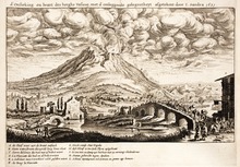
Eruption of 16 December 1631. Joachim von Sandrart and Matthias Merian in Danckerts Historis, 1642.
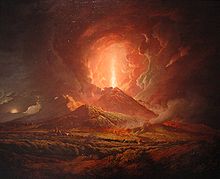
An eruption of Vesuvius seen from Portici, by Joseph Wright (c. 1774–6)

Since the eruption of AD 79, Vesuvius has erupted around three dozen times.

  • It erupted again in 203, during the lifetime of the historian Cassius Dio.
  • In 472, it ejected such a volume of ash that ashfalls were reported as far away as Constantinople (760 mi.; 1,220 km).
  • The eruptions of 512 were so severe that those inhabiting the slopes of Vesuvius were granted exemption from taxes by Theodoric the Great, the Gothic king of Italy.
  • Further eruptions were recorded in 787, 968, 991, 999, 1007 and 1036 with the first recorded lava flows.

The volcano became quiescent at the end of the 13th century, and in the following years, it again became covered with gardens and vineyards as old. Even the inside of the crater was moderately filled with shrubbery.

  • Vesuvius entered a new phase in December 1631, when a major eruption buried many villages under lava flows, killing around 3,000 people. Torrents of lahar were also created, adding to the devastation. Activity thereafter became almost continuous, with relatively severe eruptions occurring in 1660, 1682, 1694, 1698, 1707, 1737, 1760, 1767, 1779, 1794, 1822, 1834, 1839, 1850, 1855, 1861, 1868, 1872, 1906, 1926, 1929, and 1944.

Eruptions in the 20th century

  • The eruption of 5 April 1906 killed more than 100 people and ejected the most lava ever recorded from a Vesuvian eruption. Italian authorities were preparing to hold the 1908 Summer Olympics when Mount Vesuvius violently erupted, devastating the city of Naples and surrounding comunes. Funds were diverted to reconstructing Naples, and a new site for the Olympics had to be found.
  • Vesuvius was active from 1913 through 1944, with lava filling the crater and occasional outflows of small amounts of lava.
  • That eruptive period ended in the major eruption of March 1944, which destroyed the villages of San Sebastiano al Vesuvio, Massa di Somma, and Ottaviano, and part of San Giorgio a Cremano. From 13 to 18 March 1944, activity was confined within the rim. Finally, on 18 March 1944, lava overflowed the rim. Lava flows destroyed nearby villages from 19 March through 22 March. On 24 March, an explosive eruption created an ash plume and a small pyroclastic flow.

In March 1944, the United States Army Air Forces (USAAF) 340th Bombardment Group was based at Pompeii Airfield near Terzigno, Italy, just a few kilometres from the eastern base of the volcano. The tephra and hot ash from multiple days of the eruption damaged the fabric control surfaces, the engines, the Plexiglas windscreens and the gun turrets of the 340th's B-25 Mitchell medium bombers. Estimates ranged from 78 to 88 aircraft destroyed.

Ash swept off the wings of an American B-25 Mitchell medium bomber of the 340th Bombardment Group on 23 March 1944 after the eruption of Mount Vesuvius.

The eruption could be seen from Naples. Different perspectives and the damage caused to the local villages were recorded by USAAF photographers and other personnel based nearer to the volcano.

Future

Large Vesuvian eruptions which emit volcanic material in quantities of about 1 cubic kilometre (0.24 cu mi), the most recent of which overwhelmed Pompeii and Herculaneum, have happened after periods of inactivity of a few thousand years. Sub-Plinian eruptions producing about 0.1 cubic kilometres (0.024 cu mi), such as those of 472 and 1631, have been more frequent with a few hundred years between them. From the 1631 eruption until 1944, there was a comparatively small eruption every few years, emitting 0.001–0.01 km³ of magma. For Vesuvius, the amount of magma expelled in an eruption increases roughly linearly with the interval since the previous one, and at a rate of around 0.001 cubic kilometres (0.00024 cu mi) for each year. This gives an approximate figure of 0.075 cubic kilometres (0.018 cu mi) for an eruption after 75 years of inactivity.

Magma sitting in an underground chamber for many years will start to see higher melting point constituents such as olivine crystallizing out. The effect is to increase the concentration of dissolved gases (mostly sulfur dioxide and carbon dioxide) in the remaining liquid magma, making the subsequent eruption more violent. As gas-rich magma approaches the surface during an eruption, the huge drop in internal pressure caused by the reduction in weight of the overlying rock (which drops to zero at the surface) causes the gases to come out of solution, the volume of gas increasing explosively from nothing to perhaps many times that of the accompanying magma. Additionally, the removal of the higher melting point material will raise the concentration of felsic components such as silicates, potentially making the magma more viscous, adding to the explosive nature of the eruption.

The area around the volcano is now densely populated.

The government emergency plan for an eruption therefore assumes that the worst case will be an eruption of similar size and type to the 1631 VEI 4 eruption. In this scenario, the volcano's slopes, extending out to about 7 kilometres (4.3 mi) from the vent, may be exposed to pyroclastic surges sweeping down them, whilst much of the surrounding area could suffer from tephra falls. Because of prevailing winds, towns and cities south and east of the volcano are most at risk from this. It is assumed that tephra accumulation exceeding 100 kilograms per square metre (20 lb/sq ft)—at which point people are at risk from collapsing roofs—may extend out as far as Avellino to the east or Salerno to the south-east. Near Naples, this tephra fall hazard is assumed to extend barely past the volcano's slopes to the northwest. The specific areas affected by the ash cloud depend upon the circumstances surrounding the eruption.

The plan assumes between two weeks and 20 days notice of an eruption and foresees the emergency evacuation of 600,000 people, almost entirely comprising all those living in the zona rossa ("red zone"), i.e. at greatest risk from pyroclastic flows. The evacuation, by train, ferry, car, and bus, is planned to take about seven days, and the evacuees would mostly be sent to other parts of the country, rather than to safe areas in the local Campania region, and may have to stay away for several months. However, the dilemma that would face those implementing the plan is when to start this massive evacuation: If it starts too late, thousands could be killed, whereas if it is started too early, the indicators of an eruption may turn out to be a false alarm. In 1984, 40,000 people were evacuated from the Campi Flegrei area, another volcanic complex near Naples, but no eruption occurred.

The crater of Vesuvius in 2012

Ongoing efforts are being made by the government at various levels (especially of Campania) to reduce the population living in the red zone, by demolishing illegally constructed buildings, establishing a national park around the whole volcano to prevent the future construction of buildings and by offering sufficient financial incentives to people for moving away. One of the underlying goals is to reduce the time needed to evacuate the area, over the next twenty to thirty years, to two or three days.

The volcano is closely monitored by the Osservatorio Vesuvio in Naples with extensive networks of seismic and gravimetric stations, a combination of a GPS-based geodetic array and satellite-based synthetic aperture radar to measure ground movement and by local surveys and chemical analyses of gases emitted from fumaroles. All of this is intended to track magma rising underneath the volcano. As of May 2010, no magma has been detected within 10 km of the surface, so the volcano is classified by the Observatory as at a Basic or Green Level of hazard.

National park

"Etna", one of a pair of early funicular cable cars on Mount Vesuvius; the other cable car of the pair was named "Vesuvio"; about 1900

The area around Vesuvius was officially declared a national park on 5 June 1995. The summit of Vesuvius is open to visitors, and there is a small network of paths around the volcano that are maintained by the park authorities on weekends. There is access by road to within 200 metres (660 ft) of the summit (measured vertically), but after that, access is on foot only. There is a spiral walkway around the volcano from the road to the crater.

Funicular

Mount Vesuvius' first funicular — a type of vertical transport that uses two opposing, interconnected, rail-guided passenger cars always moving in concert — opened in 1880, subsequently destroyed by the March 1944 eruption.

"Funiculì, Funiculà", a Neapolitan language song, was written to commemorate the opening of the first funicular on Mount Vesuvius.

Stratovolcano

From Wikipedia, the free encyclopedia
Mount Rainier, a 4,392 m (14,411 ft) stratovolcano, the highest point in the US state of Washington
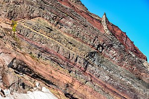
Exposed internal structure of alternating layers of lava and pyroclastic rock in the eroded Broken Top stratovolcano in Oregon

A stratovolcano, also known as a composite volcano, is a conical volcano built up by many layers (strata) of hardened lava and tephra. Unlike shield volcanoes, stratovolcanoes are characterized by a steep profile with a summit crater and periodic intervals of explosive eruptions and effusive eruptions, although some have collapsed summit craters called calderas. The lava flowing from stratovolcanoes typically cools and hardens before spreading far, due to high viscosity. The magma forming this lava is often felsic, having high to intermediate levels of silica (as in rhyolite, dacite, or andesite), with lesser amounts of less viscous mafic magma. Extensive felsic lava flows are uncommon, but have traveled as far as 15 km (9 mi).

Stratovolcanoes are sometimes called composite volcanoes because of their composite stratified structure, built up from sequential outpourings of erupted materials. They are among the most common types of volcanoes, in contrast to the less common shield volcanoes. Two examples of stratovolcanoes famous for catastrophic eruptions are Krakatoa in Indonesia, which erupted in 1883, and Vesuvius in Italy, having erupted in 79; both eruptions claimed thousands of lives. In modern times, Mount St. Helens in Washington State, US, and Mount Pinatubo in the Philippines have erupted catastrophically, but with fewer deaths.

The existence of stratovolcanoes on other bodies of the Solar System has not been conclusively demonstrated. One possible exception is the existence of some isolated massifs on Mars, for example the Zephyria Tholus.

Creation

Cross-section of subduction zone and associated stratovolcanoes

Stratovolcanoes are common at subduction zones, forming chains and clusters along plate tectonic boundaries where oceanic crust is drawn under continental crust (continental arc volcanism, e.g. Cascade Range, Andes, Campania) or another oceanic plate (island arc volcanism, e.g. Japan, Philippines, Aleutian Islands). The magma forming stratovolcanoes rises when water trapped both in hydrated minerals and in the porous basalt rock of the upper oceanic crust is released into mantle rock of the asthenosphere above the sinking oceanic slab. The release of water from hydrated minerals is termed "dewatering", and occurs at specific pressures and temperatures for each mineral, as the plate descends to greater depths. The water freed from the rock lowers the melting point of the overlying mantle rock, which then undergoes partial melting, rises (due to its lighter density relative to the surrounding mantle rock), and pools temporarily at the base of the lithosphere. The magma then rises through the crust, incorporating silica-rich crustal rock, leading to a final intermediate composition. When the magma nears the top surface, it pools in a magma chamber within the crust below the stratovolcano.

The processes that trigger the final eruption remain a question for further research. Possible mechanisms include:

  • Magma differentiation, in which the lightest, most silica-rich magma and volatiles such as water, halogens, and sulfur dioxide accumulate in the uppermost part of the magma chamber. This can dramatically increase pressures.
  • Fractional crystallization of the magma. When anhydrous minerals such as feldspar crystallize out of the magma, this concentrates volatiles in the remaining liquid, which can lead to second boiling that causes a gas phase (carbon dioxide or water) to separate from the liquid magma and raise magma chamber pressures.
  • Injection of fresh magma into the magma chamber, which mixes and heats the cooler magma already present. This could force volatiles out of solution and lower the density of the cooler magma, both of which increase pressure. There is considerable evidence for magma mixing just before many eruptions, including magnesium-rich olivine crystals in freshly erupted silicic lava that show no reaction rim. This is possible only if the lava erupted immediately after mixing since olivine rapidly reacts with silicic magma to form a rim of pyroxene.

These internal triggers may be modified by external triggers such as sector collapse, earthquakes, or interactions with groundwater. Some of these triggers operate only under limited conditions. For example, sector collapse (where part of the flank of a volcano collapses in a massive landslide) can trigger eruption only of a very shallow magma chamber. Magma differentiation and thermal expansion also are ineffective as triggers for eruptions from deep magma chambers.

Hazards

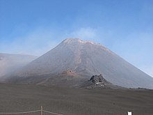
Mount Etna on the island of Sicily, in southern Italy
Mount Fuji on Honshu (top) and Mount Unzen on Kyushu (bottom), two of Japan's stratovolcanoes

In recorded history, explosive eruptions at subduction zone (convergent-boundary) volcanoes have posed the greatest hazard to civilizations. Subduction-zone stratovolcanoes, such as Mount St. Helens, Mount Etna and Mount Pinatubo, typically erupt with explosive force because the magma is too viscous to allow easy escape of volcanic gases. As a consequence, the tremendous internal pressures of the trapped volcanic gases remain and intermingle in the pasty magma. Following the breaching of the vent and the opening of the crater, the magma degasses explosively. The magma and gases blast out with high speed and full force.

Since 1600 CE, nearly 300,000 people have been killed by volcanic eruptions. Most deaths were caused by pyroclastic flows and lahars, deadly hazards that often accompany explosive eruptions of subduction-zone stratovolcanoes. Pyroclastic flows are swift, avalanche-like, ground-sweeping, incandescent mixtures of hot volcanic debris, fine ash, fragmented lava, and superheated gases that can travel at speeds over 160 km/h (100 mph). Around 30,000 people were killed by pyroclastic flows during the 1902 eruption of Mount Pelée on the island of Martinique in the Caribbean. During March and April of 1982, three explosive eruptions of El Chichón in the State of Chiapas in southeastern Mexico caused the worst volcanic disaster in that country's history. Villages within 8 km (5 mi) of the volcano were destroyed by pyroclastic flows, killing more than 2,000 people.

Two Decade Volcanoes that erupted in 1991 provide examples of stratovolcano hazards. On June 15, Mount Pinatubo spewed an ash cloud 40 km (25 mi) into the air and produced huge pyroclastic surges and lahar floods that devastated a large area around the volcano. Pinatubo, located in Central Luzon just 90 km (56 mi) west-northwest of Manila, had been dormant for six centuries before the 1991 eruption, which ranks as one of the largest eruptions in the 20th century. Also in 1991, Japan's Unzen Volcano, located on the island of Kyushu about 40 km (25 mi) east of Nagasaki, awakened from its 200-year slumber to produce a new lava dome at its summit. Beginning in June, the repeated collapse of this erupting dome generated ash flows that swept down the mountain's slopes at speeds as high as 200 km/h (120 mph). Unzen is one of more than 75 active volcanoes in Japan; an eruption in 1792 killed more than 15,000 people—the worst volcanic disaster in the nation's history.

The eruption of Mount Vesuvius in 79 completely smothered the nearby ancient cities of Pompeii and Herculaneum with thick deposits of pyroclastic surges and lava flows. Although the death toll has been estimated at between 13,000 and 26,000 people, the exact number is still unclear. Vesuvius is recognized as one of the most dangerous of the world's volcanoes, due to its capacity for powerful explosive eruptions coupled with the high population density of the surrounding Metropolitan Naples area (totaling about 3.6 million inhabitants).

Ash

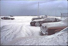
Snow-like blanket of Mount Pinatubo's ashfall deposits in a parking lot on Clark Air Base (June 15, 1991)

In addition to potentially affecting the climate, volcanic clouds from explosive eruptions pose a serious hazard to aviation. For example, during the 1982 eruption of Galunggung in Java, British Airways Flight 9 flew into the ash cloud, causing it to sustain temporary engine failure and structural damage. During the past two decades, more than 60 airplanes, mostly commercial airliners, have been damaged by in-flight encounters with volcanic ash. Some of these encounters have resulted in the loss of power in all engines, necessitating emergency landings. As of 1999, no crashes have happened because of jet aircraft flying into volcanic ash. Ashfalls are a threat to health when inhaled and ash is also a threat to property with enough accumulation. An accumulation of 30 cm (12 in) is sufficient to cause most buildings to collapse. Dense clouds of hot volcanic ash can be expelled due to the collapse of an eruptive column, or laterally due to the partial collapse of a volcanic edifice or lava dome during explosive eruptions. These clouds can generate devastating pyroclastic flows or surges, which can sweep up everything in their paths.

Lava

Mayon Volcano in Philippines extruding lava flows during its eruption on December 29, 2009

Lava flows from stratovolcanoes are generally not a significant threat to humans or animals because the highly viscous lava moves slowly enough for everyone to flee away from the path of flow. The lava flows are more of a threat to property. However, not all stratovolcanoes erupt viscous and sticky lava. Nyiragongo, near Lake Kivu in central Africa, is very dangerous because its magma has an unusually low silica content, making it quite fluid. Fluid lavas are typically associated with the formation of broad shield volcanoes such as those of Hawaii, but Nyiragongo has very steep slopes down which lava can flow at up to 100 km/h (60 mph). Lava flows could melt down ice and glaciers that accumulated on the volcano's crater and upper slopes, generating massive lahar flows. Rarely, generally fluid lava could also generate massive lava fountains, while lava of thicker viscosity can solidify within the vent, creating a volcanic plug which can result in highly explosive eruptions.

Volcanic bombs

Volcanic bombs are extrusive igneous rocks ranging from the size of books to small cars, that are explosively ejected from stratovolcanoes during their climactic eruptive phases. These "bombs" can travel over 20 km (12 mi) away from the volcano, and present a risk to buildings and living beings while shooting at very high speeds (hundreds of kilometers/miles per hour) through the air. Most bombs do not themselves explode on impact, but rather carry enough force to have destructive effects as if they exploded.

Lahar

Lahars (from a Javanese term for volcanic mudflows) are mixtures of volcanic debris and water. Lahars usually come from two sources: rainfall or the melting of snow and ice by hot volcanic elements, such as lava. Depending on the proportion and temperature of water to volcanic material, lahars can range from thick, gooey flows that have the consistency of wet concrete to fast-flowing, soupy floods. As lahars flood down the steep sides of stratovolcanoes, they have the strength and speed to flatten or drown everything in their paths. Hot ash clouds, lava flows and pyroclastic surges ejected during 1985 eruption of Nevado del Ruiz in Colombia melted snow and ice atop the 5,321 m (17,457 ft) high Andean volcano. The ensuing lahar flooded the city of Armero and nearby settlements, killing 25,000 people.

Effects on climate and atmosphere

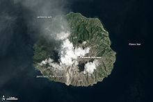
Paluweh eruption as seen from space

As per the above examples, while the Unzen eruptions have caused deaths and considerable local damage in the historic past, the impact of the June 1991 eruption of Mount Pinatubo was global. Slightly cooler-than-usual temperatures were recorded worldwide, with brilliant sunsets and intense sunrises attributed to the particulates; this eruption lofted particles high into the stratosphere. The aerosols that formed from the sulfur dioxide (SO2), carbon dioxide (CO2), and other gases dispersed around the world. The SO2 mass in this cloud—about 22 million tons—combined with water (both of volcanic and atmospheric origin) formed droplets of sulfuric acid, blocking a portion of the sunlight from reaching the troposphere and ground. The cooling in some regions is thought to have been as much as 0.5 °C (0.9 °F). An eruption the size of Mount Pinatubo tends to affect the weather for a few years; the material injected into the stratosphere gradually drops into the troposphere, where it is washed away by rain and cloud precipitation.

A similar but extraordinarily more powerful phenomenon occurred in the cataclysmic April 1815 eruption of Mount Tambora on Sumbawa island in Indonesia. The Mount Tambora eruption is recognized as the most powerful eruption in recorded history. Its eruption cloud lowered global temperatures by as much as 3.5 °C (6.3 °F). In the year following the eruption, most of the Northern Hemisphere experienced sharply cooler temperatures during the summer. In parts of Europe, Asia, Africa, and North America, 1816 was known as the "Year Without a Summer", which caused a considerable agricultural crisis and a brief but bitter famine, which generated a series of distresses across much of the affected continents.

Lake ecosystem

From Wikipedia, the free encyclopedia
The three primary zones of a lake

A lake ecosystem or lacustrine ecosystem includes biotic (living) plants, animals and micro-organisms, as well as abiotic (non-living) physical and chemical interactions. Lake ecosystems are a prime example of lentic ecosystems (lentic refers to stationary or relatively still freshwater, from the Latin lentus, which means "sluggish"), which include ponds, lakes and wetlands, and much of this article applies to lentic ecosystems in general. Lentic ecosystems can be compared with lotic ecosystems, which involve flowing terrestrial waters such as rivers and streams. Together, these two ecosystems are examples of freshwater ecosystems.

Lentic systems are diverse, ranging from a small, temporary rainwater pool a few inches deep to Lake Baikal, which has a maximum depth of 1642 m. The general distinction between pools/ponds and lakes is vague, but Brown states that ponds and pools have their entire bottom surfaces exposed to light, while lakes do not. In addition, some lakes become seasonally stratified. Ponds and pools have two regions: the pelagic open water zone, and the benthic zone, which comprises the bottom and shore regions. Since lakes have deep bottom regions not exposed to light, these systems have an additional zone, the profundal. These three areas can have very different abiotic conditions and, hence, host species that are specifically adapted to live there.

Two important subclasses of lakes are ponds, which typically are small lakes that intergrade with wetlands, and water reservoirs. Over long periods of time, lakes, or bays within them, may gradually become enriched by nutrients and slowly fill in with organic sediments, a process called succession. When humans use the watershed, the volumes of sediment entering the lake can accelerate this process. The addition of sediments and nutrients to a lake is known as eutrophication.

Zones

Lake ecosystems can be divided into zones. One common system divides lakes into three zones. The first, the littoral zone, is the shallow zone near the shore. This is where rooted wetland plants occur. The offshore is divided into two further zones, an open water zone and a deep water zone. In the open water zone (or photic zone) sunlight supports photosynthetic algae and the species that feed upon them. In the deep water zone, sunlight is not available and the food web is based on detritus entering from the littoral and photic zones. Some systems use other names. The off shore areas may be called the pelagic zone, the photic zone may be called the limnetic zone and the aphotic zone may be called the profundal zone. Inland from the littoral zone, one can also frequently identify a riparian zone which has plants still affected by the presence of the lake—this can include effects from windfalls, spring flooding, and winter ice damage. The production of the lake as a whole is the result of production from plants growing in the littoral zone, combined with production from plankton growing in the open water.

Wetlands can be part of the lentic system, as they form naturally along most lake shores, the width of the wetland and littoral zone being dependent upon the slope of the shoreline and the amount of natural change in water levels, within and among years. Often dead trees accumulate in this zone, either from windfalls on the shore or logs transported to the site during floods. This woody debris provides important habitat for fish and nesting birds, as well as protecting shorelines from erosion.

Abiotic components

Light

Light provides the solar energy required to drive the process of photosynthesis, the major energy source of lentic systems. The amount of light received depends upon a combination of several factors. Small ponds may experience shading by surrounding trees, while cloud cover may affect light availability in all systems, regardless of size. Seasonal and diurnal considerations also play a role in light availability because the shallower the angle at which light strikes water, the more light is lost by reflection. This is known as Beer's law. Once light has penetrated the surface, it may also be scattered by particles suspended in the water column. This scattering decreases the total amount of light as depth increases. Lakes are divided into photic and aphotic regions, the prior receiving sunlight and latter being below the depths of light penetration, making it void of photosynthetic capacity. In relation to lake zonation, the pelagic and benthic zones are considered to lie within the photic region, while the profundal zone is in the aphotic region.

Temperature

Temperature is an important abiotic factor in lentic ecosystems because most of the biota are poikilothermic, where internal body temperatures are defined by the surrounding system. Water can be heated or cooled through radiation at the surface and conduction to or from the air and surrounding substrate. Shallow ponds often have a continuous temperature gradient from warmer waters at the surface to cooler waters at the bottom. In addition, temperature fluctuations can vary greatly in these systems, both diurnally and seasonally.

Temperature regimes are very different in large lakes. In temperate regions, for example, as air temperatures increase, the icy layer formed on the surface of the lake breaks up, leaving the water at approximately 4 °C. This is the temperature at which water has the highest density. As the season progresses, the warmer air temperatures heat the surface waters, making them less dense. The deeper waters remain cool and dense due to reduced light penetration. As the summer begins, two distinct layers become established, with such a large temperature difference between them that they remain stratified. The lowest zone in the lake is the coldest and is called the hypolimnion. The upper warm zone is called the epilimnion. Between these zones is a band of rapid temperature change called the thermocline. During the colder fall season, heat is lost at the surface and the epilimnion cools. When the temperatures of the two zones are close enough, the waters begin to mix again to create a uniform temperature, an event termed lake turnover. In the winter, inverse stratification occurs as water near the surface cools freezes, while warmer, but denser water remains near the bottom. A thermocline is established, and the cycle repeats.

Seasonal stratification in temperate lakes

Wind

Illustration of Langmuir rotations; open circles=positively buoyant particles, closed circles=negatively buoyant particles

In exposed systems, wind can create turbulent, spiral-formed surface currents called Langmuir circulations. Exactly how these currents become established is still not well understood, but it is evident that it involves some interaction between horizontal surface currents and surface gravity waves. The visible result of these rotations, which can be seen in any lake, are the surface foamlines that run parallel to the wind direction. Positively buoyant particles and small organisms concentrate in the foamline at the surface and negatively buoyant objects are found in the upwelling current between the two rotations. Objects with neutral buoyancy tend to be evenly distributed in the water column. This turbulence circulates nutrients in the water column, making it crucial for many pelagic species, however its effect on benthic and profundal organisms is minimal to non-existent, respectively. The degree of nutrient circulation is system specific, as it depends upon such factors as wind strength and duration, as well as lake or pool depth and productivity.

Chemistry

Oxygen is essential for organismal respiration. The amount of oxygen present in standing waters depends upon: 1) the area of transparent water exposed to the air, 2) the circulation of water within the system and 3) the amount of oxygen generated and used by organisms present. In shallow, plant-rich pools there may be great fluctuations of oxygen, with extremely high concentrations occurring during the day due to photosynthesis and very low values at night when respiration is the dominant process of primary producers. Thermal stratification in larger systems can also affect the amount of oxygen present in different zones. The epilimnion is oxygen rich because it circulates quickly, gaining oxygen via contact with the air. The hypolimnion, however, circulates very slowly and has no atmospheric contact. Additionally, fewer green plants exist in the hypolimnion, so there is less oxygen released from photosynthesis. In spring and fall when the epilimnion and hypolimnion mix, oxygen becomes more evenly distributed in the system. Low oxygen levels are characteristic of the profundal zone due to the accumulation of decaying vegetation and animal matter that “rains” down from the pelagic and benthic zones and the inability to support primary producers.

Phosphorus is important for all organisms because it is a component of DNA and RNA and is involved in cell metabolism as a component of ATP and ADP. Also, phosphorus is not found in large quantities in freshwater systems, limiting photosynthesis in primary producers, making it the main determinant of lentic system production. The phosphorus cycle is complex, but the model outlined below describes the basic pathways. Phosphorus mainly enters a pond or lake through runoff from the watershed or by atmospheric deposition. Upon entering the system, a reactive form of phosphorus is usually taken up by algae and macrophytes, which release a non-reactive phosphorus compound as a byproduct of photosynthesis. This phosphorus can drift downwards and become part of the benthic or profundal sediment, or it can be remineralized to the reactive form by microbes in the water column. Similarly, non-reactive phosphorus in the sediment can be remineralized into the reactive form. Sediments are generally richer in phosphorus than lake water, however, indicating that this nutrient may have a long residency time there before it is remineralized and re-introduced to the system.

Biotic components

Co-occurrence network of a bacterial community in a lake

Bacteria

Bacteria are present in all regions of lentic waters. Free-living forms are associated with decomposing organic material, biofilm on the surfaces of rocks and plants, suspended in the water column, and in the sediments of the benthic and profundal zones. Other forms are also associated with the guts of lentic animals as parasites or in commensal relationships. Bacteria play an important role in system metabolism through nutrient recycling, which is discussed in the Trophic Relationships section.

Primary producers

Nelumbo nucifera, an aquatic plant.

Algae, including both phytoplankton and periphyton, are the principle photosynthesizers in ponds and lakes. Phytoplankton are found drifting in the water column of the pelagic zone. Many species have a higher density than water, which should cause them to sink inadvertently down into the benthos. To combat this, phytoplankton have developed density-changing mechanisms, by forming vacuoles and gas vesicles, or by changing their shapes to induce drag, thus slowing their descent. A very sophisticated adaptation utilized by a small number of species is a tail-like flagellum that can adjust vertical position, and allow movement in any direction. Phytoplankton can also maintain their presence in the water column by being circulated in Langmuir rotations. Periphytic algae, on the other hand, are attached to a substrate. In lakes and ponds, they can cover all benthic surfaces. Both types of plankton are important as food sources and as oxygen providers.

Aquatic plants live in both the benthic and pelagic zones, and can be grouped according to their manner of growth: ⑴ emergent = rooted in the substrate, but with leaves and flowers extending into the air; ⑵ floating-leaved = rooted in the substrate, but with floating leaves; ⑶ submersed = growing beneath the surface; ⑷ free-floating macrophytes = not rooted in the substrate, and floating on the surface. These various forms of macrophytes generally occur in different areas of the benthic zone, with emergent vegetation nearest the shoreline, then floating-leaved macrophytes, followed by submersed vegetation. Free-floating macrophytes can occur anywhere on the system's surface.

Aquatic plants are more buoyant than their terrestrial counterparts because freshwater has a higher density than air. This makes structural rigidity unimportant in lakes and ponds (except in the aerial stems and leaves). Thus, the leaves and stems of most aquatic plants use less energy to construct and maintain woody tissue, investing that energy into fast growth instead. In order to contend with stresses induced by the wind and waves, plants must be both flexible and tough. Light, water depth, and substrate types are the most important factors controlling the distribution of submerged aquatic plants. Macrophytes are sources of food, oxygen, and habitat structure in the benthic zone, but cannot penetrate the depths of the euphotic zone, and hence are not found there.

Invertebrates

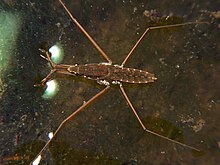
Water striders are predatory insects which rely on surface tension to walk on top of water. They live on the surface of ponds, marshes, and other quiet waters. They can move very quickly, up to 1.5 m/s.

Zooplankton are tiny animals suspended in the water column. Like phytoplankton, these species have developed mechanisms that keep them from sinking to deeper waters, including drag-inducing body forms, and the active flicking of appendages (such as antennae or spines). Remaining in the water column may have its advantages in terms of feeding, but this zone's lack of refugia leaves zooplankton vulnerable to predation. In response, some species, especially Daphnia sp., make daily vertical migrations in the water column by passively sinking to the darker lower depths during the day, and actively moving towards the surface during the night. Also, because conditions in a lentic system can be quite variable across seasons, zooplankton have the ability to switch from laying regular eggs to resting eggs when there is a lack of food, temperatures fall below 2 °C, or if predator abundance is high. These resting eggs have a diapause, or dormancy period, that should allow the zooplankton to encounter conditions that are more favorable to survival when they finally hatch. The invertebrates that inhabit the benthic zone are numerically dominated by small species, and are species-rich compared to the zooplankton of the open water. They include: Crustaceans (e.g. crabs, crayfish, and shrimp), molluscs (e.g. clams and snails), and numerous types of insects. These organisms are mostly found in the areas of macrophyte growth, where the richest resources, highly-oxygenated water, and warmest portion of the ecosystem are found. The structurally diverse macrophyte beds are important sites for the accumulation of organic matter, and provide an ideal area for colonization. The sediments and plants also offer a great deal of protection from predatory fishes.

Very few invertebrates are able to inhabit the cold, dark, and oxygen-poor profundal zone. Those that can are often red in color, due to the presence of large amounts of hemoglobin, which greatly increases the amount of oxygen carried to cells. Because the concentration of oxygen within this zone is low, most species construct tunnels or burrows in which they can hide, and utilize the minimum amount of movements necessary to circulate water through, drawing oxygen to them without expending too much energy.

Fish and other vertebrates

Fish have a range of physiological tolerances that are dependent upon which species they belong to. They have different lethal temperatures, dissolved oxygen requirements, and spawning needs that are based on their activity levels and behaviors. Because fish are highly mobile, they are able to deal with unsuitable abiotic factors in one zone by simply moving to another. A detrital feeder in the profundal zone, for example, that finds the oxygen concentration has dropped too low may feed closer to the benthic zone. A fish might also alter its residence during different parts of its life history: hatching in a sediment nest, then moving to the weedy benthic zone to develop in a protected environment with food resources, and finally into the pelagic zone as an adult.

Other vertebrate taxa inhabit lentic systems as well. These include amphibians (e.g. salamanders and frogs), reptiles (e.g. snakes, turtles, and alligators), and a large number of waterfowl species. Most of these vertebrates spend part of their time in terrestrial habitats, and thus, are not directly affected by abiotic factors in the lake or pond. Many fish species are important both as consumers and as prey species to the larger vertebrates mentioned above.

Trophic relationships

Primary producers

Lentic systems gain most of their energy from photosynthesis performed by aquatic plants and algae. This autochthonous process involves the combination of carbon dioxide, water, and solar energy to produce carbohydrates and dissolved oxygen. Within a lake or pond, the potential rate of photosynthesis generally decreases with depth due to light attenuation. Photosynthesis, however, is often low at the top few millimeters of the surface, likely due to inhibition by ultraviolet light. The exact depth and photosynthetic rate measurements of this curve are system-specific and depend upon: 1) the total biomass of photosynthesizing cells, 2) the amount of light attenuating materials, and 3) the abundance and frequency range of light absorbing pigments (i.e. chlorophylls) inside of photosynthesizing cells. The energy created by these primary producers is important for the community because it is transferred to higher trophic levels via consumption.

Bacteria

The vast majority of bacteria in lakes and ponds obtain their energy by decomposing vegetation and animal matter. In the pelagic zone, dead fish and the occasional allochthonous input of litterfall are examples of coarse particulate organic matter (CPOM>1 mm). Bacteria degrade these into fine particulate organic matter (FPOM<1 mm) and then further into usable nutrients. Small organisms such as plankton are also characterized as FPOM. Very low concentrations of nutrients are released during decomposition because the bacteria are utilizing them to build their own biomass. Bacteria, however, are consumed by protozoa, which are in turn consumed by zooplankton, and then further up the trophic levels. Elements other than carbon, particularly phosphorus and nitrogen, are regenerated when protozoa feed on bacterial prey and this way, nutrients become once more available for use in the water column. This regeneration cycle is known as the microbial loop and is a key component of lentic food webs.

The decomposition of organic materials can continue in the benthic and profundal zones if the matter falls through the water column before being completely digested by the pelagic bacteria. Bacteria are found in the greatest abundance here in sediments, where they are typically 2-1000 times more prevalent than in the water column.

Benthic invertebrates

Benthic invertebrates, due to their high level of species richness, have many methods of prey capture. Filter feeders create currents via siphons or beating cilia, to pull water and its nutritional contents, towards themselves for straining. Grazers use scraping, rasping, and shredding adaptations to feed on periphytic algae and macrophytes. Members of the collector guild browse the sediments, picking out specific particles with raptorial appendages. Deposit feeding invertebrates indiscriminately consume sediment, digesting any organic material it contains. Finally, some invertebrates belong to the predator guild, capturing and consuming living animals. The profundal zone is home to a unique group of filter feeders that use small body movements to draw a current through burrows that they have created in the sediment. This mode of feeding requires the least amount of motion, allowing these species to conserve energy. A small number of invertebrate taxa are predators in the profundal zone. These species are likely from other regions and only come to these depths to feed. The vast majority of invertebrates in this zone are deposit feeders, getting their energy from the surrounding sediments.

Fish

Fish size, mobility, and sensory capabilities allow them to exploit a broad prey base, covering multiple zonation regions. Like invertebrates, fish feeding habits can be categorized into guilds. In the pelagic zone, herbivores graze on periphyton and macrophytes or pick phytoplankton out of the water column. Carnivores include fishes that feed on zooplankton in the water column (zooplanktivores), insects at the water's surface, on benthic structures, or in the sediment (insectivores), and those that feed on other fish (piscivores). Fish that consume detritus and gain energy by processing its organic material are called detritivores. Omnivores ingest a wide variety of prey, encompassing floral, faunal, and detrital material. Finally, members of the parasitic guild acquire nutrition from a host species, usually another fish or large vertebrate. Fish taxa are flexible in their feeding roles, varying their diets with environmental conditions and prey availability. Many species also undergo a diet shift as they develop. Therefore, it is likely that any single fish occupies multiple feeding guilds within its lifetime.

Lentic food webs

As noted in the previous sections, the lentic biota are linked in complex web of trophic relationships. These organisms can be considered to loosely be associated with specific trophic groups (e.g. primary producers, herbivores, primary carnivores, secondary carnivores, etc.). Scientists have developed several theories in order to understand the mechanisms that control the abundance and diversity within these groups. Very generally, top-down processes dictate that the abundance of prey taxa is dependent upon the actions of consumers from higher trophic levels. Typically, these processes operate only between two trophic levels, with no effect on the others. In some cases, however, aquatic systems experience a trophic cascade; for example, this might occur if primary producers experience less grazing by herbivores because these herbivores are suppressed by carnivores. Bottom-up processes are functioning when the abundance or diversity of members of higher trophic levels is dependent upon the availability or quality of resources from lower levels. Finally, a combined regulating theory, bottom-up:top-down, combines the predicted influences of consumers and resource availability. It predicts that trophic levels close to the lowest trophic levels will be most influenced by bottom-up forces, while top-down effects should be strongest at top levels.

Community patterns and diversity

Local species richness

The biodiversity of a lentic system increases with the surface area of the lake or pond. This is attributable to the higher likelihood of partly terrestrial species of finding a larger system. Also, because larger systems typically have larger populations, the chance of extinction is decreased. Additional factors, including temperature regime, pH, nutrient availability, habitat complexity, speciation rates, competition, and predation, have been linked to the number of species present within systems.

Succession patterns in plankton communities – the PEG model

Phytoplankton and zooplankton communities in lake systems undergo seasonal succession in relation to nutrient availability, predation, and competition. Sommer et al. described these patterns as part of the Plankton Ecology Group (PEG) model, with 24 statements constructed from the analysis of numerous systems. The following includes a subset of these statements, as explained by Brönmark and Hansson illustrating succession through a single seasonal cycle:

Winter
1. Increased nutrient and light availability result in rapid phytoplankton growth towards the end of winter. The dominant species, such as diatoms, are small and have quick growth capabilities. 2. These plankton are consumed by zooplankton, which become the dominant plankton taxa.

Spring
3. A clear water phase occurs, as phytoplankton populations become depleted due to increased predation by growing numbers of zooplankton.

Summer
4. Zooplankton abundance declines as a result of decreased phytoplankton prey and increased predation by juvenile fishes.
5. With increased nutrient availability and decreased predation from zooplankton, a diverse phytoplankton community develops.
6. As the summer continues, nutrients become depleted in a predictable order: phosphorus, silica, and then nitrogen. The abundance of various phytoplankton species varies in relation to their biological need for these nutrients.
7. Small-sized zooplankton become the dominant type of zooplankton because they are less vulnerable to fish predation.

Fall
8. Predation by fishes is reduced due to lower temperatures and zooplankton of all sizes increase in number.

Winter
9. Cold temperatures and decreased light availability result in lower rates of primary production and decreased phytoplankton populations. 10. Reproduction in zooplankton decreases due to lower temperatures and less prey.

The PEG model presents an idealized version of this succession pattern, while natural systems are known for their variation.

Latitudinal patterns

There is a well-documented global pattern that correlates decreasing plant and animal diversity with increasing latitude, that is to say, there are fewer species as one moves towards the poles. The cause of this pattern is one of the greatest puzzles for ecologists today. Theories for its explanation include energy availability, climatic variability, disturbance, competition, etc. Despite this global diversity gradient, this pattern can be weak for freshwater systems compared to global marine and terrestrial systems. This may be related to size, as Hillebrand and Azovsky found that smaller organisms (protozoa and plankton) did not follow the expected trend strongly, while larger species (vertebrates) did. They attributed this to better dispersal ability by smaller organisms, which may result in high distributions globally.

Natural lake lifecycles

Lake creation

Lakes can be formed in a variety of ways, but the most common are discussed briefly below. The oldest and largest systems are the result of tectonic activities. The rift lakes in Africa, for example are the result of seismic activity along the site of separation of two tectonic plates. Ice-formed lakes are created when glaciers recede, leaving behind abnormalities in the landscape shape that are then filled with water. Finally, oxbow lakes are fluvial in origin, resulting when a meandering river bend is pinched off from the main channel.

Natural extinction

All lakes and ponds receive sediment inputs. Since these systems are not really expanding, it is logical to assume that they will become increasingly shallower in depth, eventually becoming wetlands or terrestrial vegetation. The length of this process should depend upon a combination of depth and sedimentation rate. Moss gives the example of Lake Tanganyika, which reaches a depth of 1500 m and has a sedimentation rate of 0.5 mm/yr. Assuming that sedimentation is not influenced by anthropogenic factors, this system should go extinct in approximately 3 million years. Shallow lentic systems might also fill in as swamps encroach inward from the edges. These processes operate on a much shorter timescale, taking hundreds to thousands of years to complete the extinction process.

Human impacts

Acidification

Sulfur dioxide and nitrogen oxides are naturally released from volcanoes, organic compounds in the soil, wetlands, and marine systems, but the majority of these compounds come from the combustion of coal, oil, gasoline, and the smelting of ores containing sulfur. These substances dissolve in atmospheric moisture and enter lentic systems as acid rain. Lakes and ponds that contain bedrock that is rich in carbonates have a natural buffer, resulting in no alteration of pH. Systems without this bedrock, however, are very sensitive to acid inputs because they have a low neutralizing capacity, resulting in pH declines even with only small inputs of acid. At a pH of 5–6 algal species diversity and biomass decrease considerably, leading to an increase in water transparency – a characteristic feature of acidified lakes. As the pH continues lower, all fauna becomes less diverse. The most significant feature is the disruption of fish reproduction. Thus, the population is eventually composed of few, old individuals that eventually die and leave the systems without fishes. Acid rain has been especially harmful to lakes in Scandinavia, western Scotland, west Wales and the north eastern United States.

Eutrophication

Eutrophic systems contain a high concentration of phosphorus (~30 µg/L), nitrogen (~1500 µg/L), or both. Phosphorus enters lentic waters from sewage treatment effluents, discharge from raw sewage, or from runoff of farmland. Nitrogen mostly comes from agricultural fertilizers from runoff or leaching and subsequent groundwater flow. This increase in nutrients required for primary producers results in a massive increase of phytoplankton growth, termed a "plankton bloom." This bloom decreases water transparency, leading to the loss of submerged plants. The resultant reduction in habitat structure has negative impacts on the species that utilize it for spawning, maturation, and general survival. Additionally, the large number of short-lived phytoplankton result in a massive amount of dead biomass settling into the sediment. Bacteria need large amounts of oxygen to decompose this material, thus reducing the oxygen concentration of the water. This is especially pronounced in stratified lakes, when the thermocline prevents oxygen-rich water from the surface to mix with lower levels. Low or anoxic conditions preclude the existence of many taxa that are not physiologically tolerant of these conditions.

Invasive species

Invasive species have been introduced to lentic systems through both purposeful events (e.g. stocking game and food species) as well as unintentional events (e.g. in ballast water). These organisms can affect natives via competition for prey or habitat, predation, habitat alteration, hybridization, or the introduction of harmful diseases and parasites. With regard to native species, invaders may cause changes in size and age structure, distribution, density, population growth, and may even drive populations to extinction. Examples of prominent invaders of lentic systems include the zebra mussel and sea lamprey in the Great Lakes.

Spatial ability

From Wikipedia, the free encyclopedia https://en.wikipedia.org/wiki/Spatial_ability Space Engineer...