Search This Blog

Friday, January 24, 2020

Environmental issues in Australia

 
A rabbit-proof fence enforces a barrier to protect agriculture areas in Western Australia. Rabbits are an invasive species in Australia.

Environmental issues in Australia describes a number of environmental issues which affect the environment of Australia. There are a range of such issues, some of the relating to conservation in Australia while others, for example the deteriorating state of Murray-Darling Basin, have a direct and serious effect on human land use and the economy.

Many human activities including the use of natural resources have a direct impact on the Australian environment.

These issues are the primary concern of the environmental movement in Australia.

Climate change


Climate change is now a major political talking point in Australia in the last two decades. Persistent drought, and resulting water restrictions during the first decade of the twenty-first century, are an example of natural events' tangible effect on economic and political realities .

Australia ranks within the top ten countries globally with respect to greenhouse gas emissions per capital.

The current federal and state governments have all publicly stated their belief that climate change is being caused by anthropogenic greenhouse gas emissions. Vocal minority groups within the population campaign against mining and coal-fired power stations in Australia, and such demonstrations are widely reported by the mainstream media. Similarly, vocal minority groups concurrently oppose wind energy schemes, despite being 'carbon neutral', on the grounds of local visual and noise impact and concern for the currently high cost and low reliability of wind energy.

Despite the publication of the Garnaut report and the Green Paper on the proposed Carbon Pollution Reduction Scheme, public belief in anthropogenic climate change has noticeably eroded following the leaking of e-mails from the University of East Anglia's Climate Research Unit.

There is claimed to be a net benefit to Australia in stabilising greenhouse gases in the atmosphere at 450ppm CO2 eq in line with the prevailing political stance. Public disagreement with this opinion is generally dismissed as expression of vested interests, for example from the coal industry.

Energy use

Australia is a major exporter and consumer of coal, the combustion of which liberates CO2. Consequently, in 2003 Australia was the eighth highest emitter of CO2 gases per capita in the world liberating 16.5 tonnes per capital. Australia is claimed to be one of the countries most at risk from climate change according to the Stern report.

Most of Australia's demand for electricity depends upon coal-fired thermal generation, owing to the plentiful indigenous coal supply, limited potential electric generation and political unwillingness to exploit indigenous uranium resources (although Australia accounted for the world's second highest production of uranium in 2005 to fuel a 'carbon neutral' domestic nuclear energy program.

Conservation

Conservation in Australia is an issue of state and federal policy. Australia is one of the most biologically diverse countries in the world, with a large portion of species endemic to Australia. Preserving this wealth of biodiversity is important for future generations.

A key conservation issue is the preservation of biodiversity, especially by protecting the remaining rainforests. The destruction of habitat by human activities, including land clearing, remains the major cause of biodiversity loss in Australia. The importance of the Australian rainforests to the conservation movement is very high. Australia is the only western country to have large areas of rainforest intact. Forests provide timber, drugs, and food and should be managed to maximize the possible uses. Currently, there are a number of environmental movements and campaigners advocating for action on saving the environment, one such campaign is the Big Switch.

Land management issues including clearance of native vegetation, reafforestation of once-cleared areas, control of exotic weeds and pests, expansion of dryland salinity, and changed fire regimes. Intensification of resource use in sectors such as forestry, fisheries, and agriculture are widely reported to contribute to biodiversity loss in Australia. Coastal and marine environments also have reduced biodiversity from reduced water quality caused by pollution and sediments arising from human settlements and agriculture. In central New South Wales where there are large plains of grassland, problems have risen from—unusual to say—lack of land clearing.

The Daintree Rainforest, a tropical rainforest near Daintree, Queensland covering around 1200 square kilometres, is threatened by logging, development, mining and the effects of the high tourist numbers.
There are some government programs in Australia which are the opposite of conservation (such as killing wildlife); an example of this is shark culling, which currently occurs in New South Wales and Queensland.

Native fauna

The Tasmanian devil, officially listed as an endangered species in 2008.

Over a hundred species of fauna are currently under serious threat of extinction. The plight of some of these species receives more attention than others and recently the focus of many conservation organisations has been the critically endangered northern hairy-nosed wombat, the endangered Tasmanian devil, northern tiger quoll, south eastern red-tailed black cockatoo, southern cassowary, Tasmanian wedge-tailed eagle, Leadbeater's possum and southern corroboree frog.

Australia has a poor record of conservation of native fauna. The extinction of Australian megafauna is attributed to the arrival of humans and since European settlement, 23 birds, 4 frogs, and 27 mammal species are also known to have become extinct.

Marine conservation

Recent climate change reports have highlighted the threat of higher water temperatures to the Great Barrier Reef
 
One of the notable issues with marine conservation in Australia is the protection of the Great Barrier Reef. The Great Barrier Reef's environmental pressures include water quality from runoff, climate change and mass coral bleaching, cyclic outbreaks of the crown-of-thorns starfish, overfishing, and shipping accidents. The government of Queensland currently kills sharks in the Great Barrier Reef using drum lines, causing damage to the marine ecosystem.

Whaling

Whaling in Australia took place from colonisation in 1788. In 1979 Australia terminated whaling and committed to whale protection. The main varieties hunted were humpback, blue, right and sperm whales.

Shark culling

Western Australia culled sharks in 2014, killing dozens of tiger sharks and causing public protest. Later that year it was abandoned, and the government of Western Australia continued to shoot and kill sharks it believed to be an "imminent threat" to humans from 2014 to 2017; this policy was criticized by senator Rachel Siewart for being environmentally damaging.

From 1962 to the present, the government of Queensland has killed sharks on drum lines and shark nets, a process that also kills other animals such as dolphins and dugongs. From 1962 to 2018, Queensland's "shark control" program killed roughly 50,000 sharks, including sharks in the Great Barrier Reef. Queensland's shark-killing program has been called "outdated, cruel and ineffective".

New South Wales has a shark net program that kills sharks as well as other marine life. Between 1950 and 2008, 352 tiger sharks and 577 great white sharks were killed in the nets in New South Wales — also during this period, a total of 15,135 marine animals were killed in the nets, including whales and turtles. There has been a very large decrease in the number of sharks in eastern Australia in recent years, and the shark-killing programs in Queensland and New South Wales are partly responsible for this decrease.

Jessica Morris of Humane Society International calls shark culling a "knee-jerk reaction" and says, "sharks are top order predators that play an important role in the functioning of marine ecosystems. We need them for healthy oceans."

Oil spills

While there have been no oil spill environmental disasters of the scale of the Exxon Valdez in the country, Australia has a large oil industry and there have been several large oil spills. Spills remain a serious threat to the marine environment and Australian coastline. The largest spill to date was the Kirki tanker in 1991 which dropped 17,280 tonnes of oil off the coast of Western Australia

In March 2009, the 2009 southeast Queensland oil spill occurred, where 200,000 litres were spilled from the MV Pacific Adventurer spilling more than 250 tonnes of oil, 30 tonnes of fuel and other toxic chemicals on Brisbane's suburban beaches. Premier Anna Bligh described the spill as "worst environmental disaster Queensland has ever seen".

Ocean dumping

A serious issue to the Australian marine environment is the dumping of rubbish from ships. There have been a number of cases, particularly involving the navy of Australian and other countries polluting Australian waters including the dumping of chemical warfare agents. Recently documented cases include the aircraft carrier USS Ronald Reagan in 2006 which was found to be dumping rubbish off the shores of Moreton Island. In Victoria, a large number of toxic drums containing 1,2-Dichlorobenzene xylenol, a substance very toxic to aquatic creatures washed up on beaches during May 2009 presumably fallen off a passing container ship.

Invasive species

Introduced cane toads threaten native species

Australia's geographical isolation has resulted in the evolution of many delicate ecological relationships that are sensitive to foreign invaders and in many instances provided no natural predators for many of the species subsequently introduced. Introduced plants that have caused widespread problems are lantana and the prickly pear bush. The introduction and spread of animals such as the cane toad or rabbit can disrupt the existing balances between populations and develop into environmental problems. The introduction of cattle into Australia and to a lesser extent the dingo, are other examples of species that have changed the landscape. In some cases the introduction of new species can lead to plagues and the extinction of endemic species.

The introduced species red fox has single-handedly caused the extinction of several species. Tasmania takes the threat of red fox introduction so seriously that it has a government sponsored taskforce to prevent fox populations from taking hold on the island.

Land degradation

According to Jared Diamond, "Australia's number-one environmental problem [is] land degradation". Land degradation results from nine types of damaging environmental impacts:

Logging and woodchopping

Clearcutting of old growth forests is continuing in parts of Australia. This often involves the destruction of natural ecosystems and the replacement with monoculture plantations.

Land clearing

In the prehistory of Australia the Indigenous Australians used fire-stick farming which was an early form of land clearing which caused long term changes to the ecology. With European colonisation land clearing continued on a larger scale for agriculture - particularly for cattle, cotton and wheat production. Since European settlement a total of 13% of native vegetation cover has been lost. The extinction of 20 different mammals, 9 bird and 97 plant species have been partially attributed to land clearing. Land clearing is a major source of Australia’s greenhouse gas emissions, and contributed to approximately 12 percent of Australia’s total emissions in 1998.

The consequences of land clearing include dryland salinity and soil erosion. These are a major concern to the landcare movement in Australia.

The clearing of native vegetation is controlled by Federal laws (indirectly), State law and local planning instruments. The precise details of regulation of vegetation clearing differ according to the location where clearing is proposed.

Soil salinity

Soil salinity affects 50,000 km² of Australia and is predominantly due to land clearance.

Waterway health

A Parks Victoria litter trap on the river catches floating rubbish on the Yarra at Birrarung Marr
 
The protection of waterways in Australia is a major concern for various reasons including habitat and biodiversity, but also due to use of the waterways by humans.

The Murray-Darling Basin is under threat due to irrigation in Australia, causing high levels of salinity which affect agriculture and biodiversity in New South Wales, Victoria and South Australia. These rivers are also affected by pesticide run-off and drought.

Australian waterways facing environmental issues

Rivers and creeks in urban areas also face environmental issues, particularly pollution.

Victoria


New South Wales

Remediation of soil and sediment from Homebush Bay on the Parramatta River by desorbtion and incineration

Queensland


South Australia


Water use

Water use is a major sustainability issue in Australia in regards to water security. Reliable and safe water sources are threatened by a number of factors. These include climate change, rainfall variability, population growth, economic development, and drought.

Australia also has naturally highly variable rainfall influenced by events such as El Niño and La Niña. An El Niño was declared in May 2015. The El Niño’s likely impact will be drier and warmer conditions across inland eastern Australia. Importantly, the strength of an El Niño does not always indicate how severely Australia may be affected.

Dryer conditions and droughts, such as the one south east Australia is currently experiencing, increase pressure on the water supply of effected regions. In particular, increased water demands and reduced stream flows have seen a decline in surface water storage volumes. 

Urbanisation

The urban sprawl of Melbourne.

Australia is one of the most urbanised countries in the world. Many Australian cities have large urban footprints and are characterised by an unsustainable low density urban sprawl. This places demand on infrastructure and services which contributes to the problems of land clearing, pollution, transport related emissions, energy consumption, invasive species, automobile dependency and urban heat islands

A Queensland beach with the skyline of the heavily developed Gold Coast in the background. Formerly swamplands, the city was urbanised on a coastal strip between waterways and the sea and now contains many high rises.
 
The urban sprawl continues to increase at a rapid rate in most Australian cities, particularly the state capital cities, all of which (with the exception of Hobart) are metropoleis. In some centres, such as Sydney and Greater Western Sydney, Greater Melbourne and South East Queensland large metropolitan conurbations threaten to extend for hundreds of kilometres and based on current population growth rates are expected to become megacities in the 21st century. Most Australian cities population growth is a result of migration in contrast to the Birth rate and fertility rate in Australia, which is contributing to the ongoing trend of urbanisation

In recent years, some cities have implemented transit-oriented development strategies to curb the urban sprawl. Notable examples include Melbourne 2030, South East Queensland Regional Plan and the Sydney Metropolitan Strategy. There are also population decentralisation programs at state and federal levels aimed at shifting populations out of the major centres and stemming the drivers to rapid urbanisation. Albury-Wodonga was part of the federal government's program of decentralisation begun in the 1970s, which has at times had relocation policies for immigration. The Victorian government has run a decentralisation program since the 1960s, having had a ministerial position appointed and ongoing promotional and investment programs for stimulating growth in Regional Victoria. However policy has swung over the decades, primarily due to local development priorities and agendas and a lack of federal co-ordination to the problem.

Issues include large quantities of e-waste and toxic waste going into landfill. Australia does not have restrictions on the dumping of toxic materials that are common in other countries, such as dumping Cathode Ray Tubes which leach heavy metals into water catchments. Due to the lack of sufficient sites for toxic waste disposal large quantities of toxic waste are trucked between states to remote dumping grounds or exported overseas in ships.

Mining issues

Australia has the largest reserves of uranium in the world and there has been a number of enquiries on uranium mining. The anti-nuclear movement in Australia is actively opposing mining as well as preventing the construction of nuclear power plants.

At least 150 leaks, spills and licence breaches have occurred at the Ranger uranium mine between 1981 and 2009.

Invasive species in Australia

 
Common invasive species in the Adelaide Hills: olive, artichoke thistle, fennel and bamboo
 
A European rabbit (Oryctolagus cuniculus) in Tasmania

Invasive species are a serious threat to the native biodiversity of Australia and are an ongoing cost to Australian agriculture. Numerous species arrived with European colonisation of Australia and steadily since then.

Management and the prevention of the introduction of new invasive species are key environmental and agricultural policy issues for the Australian federal and state governments. The management of weeds costs A$1.5 billion on weed control and a further $2.5 billion yearly in lost agricultural production.

Causes

Both geologic and climatic events helped to make Australia's fauna unique. Australia was once part of the southern supercontinent Gondwana, which also included South America, Africa, India and Antarctica. Gondwana began to break up 140 million years ago (MYA); 50 MYA Australia separated from Antarctica and was relatively isolated until the collision of the Indo-Australian Plate with Asia in the Miocene era 5.3 MYA. As Australia drifted, it was isolated from evolutionary pressures in the rest of the world. Other examples of island isolation include Madagascar, New Zealand, Socotra, the Galapagos and Mauritius.

The placental mammals made their reappearance in Australia in the Pleistocene, as Australia continued to move closer to Indonesia, both bats and rodents appearing reliably in the fossil record. The geographic isolation of Australia created a sharp division between Australian fauna and Asian fauna at the Wallace line

Brumbies at Snowy Wilderness retreat in Jindabyne, New South Wales, 2003

Humans arrived in Australia between 65,000 and 80,000 years ago, living alongside megafauna for 20,000-25,000 years before the megafaunal extinctions that were likely caused by, or partly contributed to, by late Pleistocene climate change however the full reason for the extinctions is still unclear & human hunting or habitat changes through Fire-stick farming may also have contributed to the extinctions. This left Australia with much of its keystone species extinct, leaving the ecosystems altered and far more vulnerable to invasion.

Dingoes probably arrived in Australia between 4,600 and 5,400 years ago, long after the first humans, spread rapidly across the continent and probably contributed to the extinction of even more native species. The current period of invasive species introduction began in 1788 with the arrival of the first European settlers. The population density in Australia beyond the coastline and major cities has been very low since the arrival of European settlers and there are large tracts of land where, it is very difficult for people to manage even large feral animals like camels, horses, donkeys and water buffalos. 

Invasive species


Fungi and bacteria

Invasive fungi and bacteria in Australia affect many native plants and animals and agricultural crops. Recently citrus canker was introduced into Australia, and many Queensland citrus orchards have been burned to remove the disease. The fungus Phytophthora cinnamomi, commonly known as wildflower dieback or jarrah blight, has created a massive problem in some types of native vegetation – especially jarrah forest and banksia woodland.

Animals

Australia is host to 56 introduced invasive vertebrate animal species. They can be categorised in the following ways:
  • Invasive – species has a tendency to spread their range into new areas or plague their range
  • Ferals – defined as animals for domestic purposes (i.e. pets, recreational use – such as hunting – or beasts of burden) which have gone wild.
  • Pests – animals which have a direct effect on human standard of living or the environment/ecosystems in areas where they are present, have a high rate of reproduction and are difficult to control

Control

Various programs exist to control invasive species in Australia. A cane toad control program aims at preventing the spread of the species towards Darwin and Western Australia, and involves trapping. Foxes are often baited, although the use of 1080 (sodium fluoroacetate) is also known to affect native animals such as the quoll and Tasmanian devil, though the most common and effective method is shooting. 1080 is ideal in the south-west of Australia because a native plant contains the same toxin – therefore most native animals have developed immunity to it. Other species are either open to hunting as a sport (such as the deer) or subject to government sponsored culling programs. Camels and buffalo are often shot from helicopters

Bounties
Several bounty programs have assisted in the eradication of larger sized pests in Australia.

Ironically, many early bounties were paid for the extermination of native species that were considered a pest to farmers. The Tasmanian tiger or thylacine was one such program that caused extinction, whilst the Tasmanian devil, spotted quoll, and Tasmanian wedge-tailed eagle all became seriously threatened by bounties.

At various times, bounties have been in place for invasive species such as wild-living domestic dogs (including the dingo) and fox. A beer-for-toads bounty has been publicised for cane toad control in the Northern Territory.

In 2002, a Victorian Fox Bounty Trial began to test the efficacy of fox bounties which have been in place intermittently since 1893 (only 30 years after introduction). The study showed no reduction in fox impacts, and that the project may even have been counterproductive. The evaluation also found that a sustained annual reduction of 65% is required to achieve real declines in fox populations.

Feral cat bounties in Queensland have also been considered to counter the growing problem. The dingo is subject to various controversial bounty systems in Australia. The Australian dingo was itself introduced before European settlement, yet has been considered native of the mainland in most cases and is considered a pest to livestock. 

Invasive birds

Feral rock pigeons are common pests in public spaces in cities
 
Introduced birds considered pests include the common myna, the common starling, the spotted dove and rock pigeon (common pigeon). 

Initially introduced to control locust plagues, the Indian myna breeds prolifically in urban environments in the eastern states. The myna poses a serious threat (such that it has been listed in the World Conservation Union's world's 100 worst invasive species). The bird has caused human health concerns due to the spread of mites and disease and it has also been known to force native birds and their eggs from their nests. 

The rock pigeon in particular has acidic faeces and can damage human property, including historic stone buildings. 

Control
Historically, control programs have struggled to curb the expansion and proliferation of invasive bird populations in Australia. A new program in Canberra has reversed this trend regarding mynas. Since 2006 the Canberra Indian Myna Action Group (CIMAG) has implemented an effective control scheme, based upon large-scale trapping conducted by volunteers. As of June 2013 the Action Group has recorded over 45,000 myna captures in the Canberra region since 2006. This has reduced the myna's prevalence in the Canberra region from a ranking of third most prevalent bird species in 2006, to twentieth in 2012. This has correlated with anecdotal evidence of increased nesting activity and prevalence of native species in the Canberra region. Other volunteer organisations in Australia have begun to adopt the CIMAG model with similar success.

Starlings and sparrows are currently closely monitored in south-eastern Western Australia. 

Despite the number of rock pigeons, many people continue to feed the birds bread crumbs and assist them to breed in great numbers. It is not illegal to feed pigeons in Australia, and many local proposals to cull pigeons have been rejected.

Programs promoting indigenous plantations to attract native birds are an alternative method of promoting native species rejuvenation. 

Invasive freshwater fish species

Invasive freshwater fish species in Australia include carp, brown trout, rainbow trout, redfin perch, mosquitofish (Gambusia spp), weather loach, and spotted tilapia among others. Some introduced freshwater fish species have had devastating impacts on Australia's endemic freshwater fish species and other native aquatic life. For example, in much of south eastern Australia's freshwater systems introduced carp (often incorrectly called "European" carp) dominate the lowland reaches, while introduced trout species almost completely dominate the upland reaches. While the damaging impact of carp is well recognised, little in the way of control measures have been employed to control their spread. Their ability to colonise almost any body of water, even those previously considered to be beyond their physical tolerances, is now well established.

Insects and other invertebrates

Fire ant

Problem insects include red imported fire ants (Solenopsis invicta), yellow crazy ants (Anoplolepis gracilipes), black Portuguese millipedes (Ommatoiulus moreletii), Western honey bees (Apis mellifera), and European wasps (Vespula germanica; known elsewhere by the common name "German wasps"). The elm leaf beetle (Pyrrhalta luteola), discovered in Victoria in 1989 devastates exotic elm trees, themselves imported, and a parasite wasp species as well as the beetle's natural enemy the parasitic fly (Erynniopsis antennata) were in turn introduced in 2001 in an effort to control the pest. 

Control
Both the honey bee and European wasp are well established and now impossible to eradicate in Australia. Honey bees take over potential nesting hollows for native animals and are very hard to remove once established.

The fire ant in particular, with its venomous stings, poses a direct threat to human lifestyle. Although control is extremely difficult and spread quickly, the species is currently effectively quarantined to South East Queensland.

The yellow crazy ant is currently quarantined to Christmas Island where it has had a significant environmental impact. The primary impact is the killing and displacing of crabs on the forest floor.

Invasive marine species

A number of marine pests have arrived in Australia in the ballast water of cargo ships. Marine pests include the black-striped mussel (Mytilopsis sallei), the Asian mussel, the New Zealand green-lipped mussel, and the European shore crab. The Northern Pacific seastar in Tasmania, Inverloch, and Port Phillip has caused much localised environmental damage.

Invasive plant species

Weeds invade natural landscapes, waterways, and agricultural land. Originally, plants were most likely to be considered weeds if they had a direct economic impact, especially on agricultural production. However, growing environmental consciousness since the 1970s has led to the recognition of environmental weeds; plants which have adverse effects on the natural ecosystem of an area. A list of Weeds of National Significance (WONS) was created in 1999 and updated in 2012 and now has 32 taxa.

Weed management costs the Australian economy A$4 billion yearly; weeds are considered the second greatest threat to biodiversity after land clearing. Almost half of Australia's 220 declared noxious weeds (under legislation) were introduced deliberately, one third of these as garden ornamentals. 

Management of invasive species

The management of invasive species is carried out by individuals, conservation groups, and government agencies.

The Australian Quarantine and Inspection Service is responsible for ensuring that no new species with the potential to become invasive species enter Australia. To raise public awareness, Australian Quarantine has featured Australian celebrity nature lover Steve Irwin on a series of television commercials, with the message Quarantine – Don't mess with it.

Several scientific bodies are involved in research for the control of invasive species. The CSIRO has released several successful biological pest control agents and developed chemical agents for pest and weed control. For example, the CSIRO released myxoma virus to control wild rabbits in Australia. Rabbit haemorrhagic disease escaped containment from an Australian Government research facility and spread across Australia. Rabbit hemorrhagic disease was subsequently legalised for the control of wild rabbits. The moth Cactoblastis cactorum was introduced for the control of prickly pear, and the salvinia weevil Cyrtobagous salviniae for the control of aquatic weed Salvinia. More doubtful biological controls were the cane toad, which was introduced to control the sugar cane destroying cane beetle; instead the cane toad ate anything and everything else—the beetle was not its preferred food source given choice. The cane toad in Australia has become the biological control that is most infamous for having been a complete failure as well as becoming an environmental nightmare. Walter Froggatt, an economic entomologist, warned of this likelihood at the time. It has also led to much public concern and caution when considering the introduction of new biological controls.

Another example of a poorly researched introduced biological control is the sap sucking lantana bug (Aconophora compressa) also from South America that was introduced into Australia in the 1995 to eat the lantana. Unfortunately, the lantana bug also attacks other trees including fiddlewood trees which has caused distress to some gardeners. The lantana bug had been tested for six years on 62 different plants. Aconophora compressa was the 28th insect introduced to control lantana in about 80 years.

More successfully, the Australian Dung Beetle Project (1965–1985), led by Dr. George Bornemissza of CSIRO's Division of Entomology, introduced 23 species of dung beetle to Australia in order to biologically control the pestilent population of bush flies. These flies, along with other species of fly and parasitic worm, use the dung as a breeding and feeding ground. The rolling and burying activity of the dung beetles means that the dung is removed from the pasture land, which had the effect of reducing bush fly number by 90%, as well increasing soil fertility and quality by recycling the dung back into the soil.

Cooperative Research Centres for weed management and pest animal control, have been established by the federal government. They coordinate research and funding between a number of university and government labs for research into control of invasive species.

Non government organisations have also been established to fight invasive species, for example, the Invasive Species Council (ISC). The ISC are a policy, advocacy, lobbying, research, and outreach group on matters related invasive species. 

Volunteer groups, such as SPRATS, have also made very significant contributions to fighting invasive species, in their case removing sea spurge from large areas of Tasmanian coastline.

World Trade Organisation and Australia's quarantine regulations

The World Trade Organisation specified quarantine regulations are weaker than Australia's fairly stringent regulations controlling the importing of raw produce. Following Australia's membership of the WTO, many forms of raw produce once banned have commenced import, with potentially adverse effects and controversy; for example, regarding proposals to import apples from New Zealand or bananas from the Philippines.

Australian quarantine regulations such as those limiting banana imports from developing economies have been recognised as protectionist trade barriers by economists including Kevin Fox, head of Economics at the Australian School of Business.

The weakening of restrictions on importing raw produce into Australia mandated by the World Trade Organisation Future may pose risks of introducing exotic disease organisms. Case examples include, Chytrid fungus that is threatening numerous Australian frog species with extinction and mass pilchards deaths in the Southern Ocean from 1995 onwards that are suspected to have been caused by a virus that may have been brought in with imported pilchards.

Geography of Africa

From Wikipedia, the free encyclopedia
https://en.wikipedia.org/wiki/Geography_of_Africa
 
LocationAfrica.png

Africa is a continent comprising 63 political territories, representing the largest of the great southward projections from the main mass of Earth's surface. Within its regular outline, it comprises an area of 30,368,609 km2 (11,725,385 sq mi), excluding adjacent islands. Its highest mountain is Mount Kilimanjaro, its largest lake is Lake Victoria.

Separated from Europe by the Mediterranean Sea and from much of Asia by the Red Sea, Africa is joined to Asia at its northeast extremity by the Isthmus of Suez (which is transected by the Suez Canal), 130 km (81 mi) wide. For geopolitical purposes, the Sinai Peninsula of Egypt – east on the Suez Canal – is often considered part of Africa. From the most northerly point, Ras ben Sakka in Tunisia, at 37°21′ N, to the more southerly point, Cape Agulhas in South Africa, 34°51′15″ S, is a distance approximately of 8,000 km (5,000 mi); from Cap-Vert, 17°31′13″W, the westernmost point, to Ras Hafun in the Somali Puntland region, in the Horn of Africa, 51°27′52″ E, the most easterly projection, is a distance (also approximately) of 7,400 km (4,600 mi).

The main structural lines of the continent show both the east-to-west direction characteristic, at least in the eastern hemisphere, of the more northern parts of the world, and the north-to-south direction seen in the southern peninsulas. Africa is thus mainly composed of two segments at right angles, the northern running from east to west, and the southern from north to south.

Main features

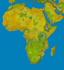
Satellite view of Africa
 
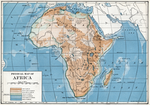
1916 physical map of Africa
 
The average elevation of the continent approximates closely to 600 m (2,000 ft) above sea level, roughly near to the mean elevation of both North and South America, but considerably less than that of Asia, 950 m (3,120 ft). In contrast with other continents, it is marked by the comparatively small area of either very high or very low ground, lands under 180 m (590 ft) occupying an unusually small part of the surface; while not only are the highest elevations inferior to those of Asia or South America, but the area of land over 3,000 m (9,800 ft) is also quite insignificant, being represented almost entirely by individual peaks and mountain ranges. Moderately elevated tablelands are thus the characteristic feature of the continent, though the surface of these is broken by higher peaks and ridges. (So prevalent are these isolated peaks and ridges that a specialised term [Inselberg-Landschaft, island mountain landscape] has been adopted in Germany to describe this kind of country, thought to be in great part the result of wind action.) 

As a general rule, the higher tablelands lie to the east and south, while a progressive diminution in altitude towards the west and north is observable. Apart from the lowlands and the Atlas mountain range, the continent may be divided into two regions of higher and lower plateaus, the dividing line (somewhat concave to the north-west) running from the middle of the Red Sea to about 6 deg. S. on the west coast. 

Africa can be divided into a number of geographic zones:
  • The coastal plains — often fringed seawards by mangrove swamps — never stretching far from the coast, apart from the lower courses of streams. Recent alluvial flats are found chiefly in the delta of the more important rivers. Elsewhere, the coastal lowlands merely form the lowest steps of the system of terraces that constitutes the ascent to the inner plateaus.
  • The Atlas range — orthographically distinct from the rest of the continent, being unconnected with and separated from the south by a depressed and desert area (the Sahara).

Plateau region

Topography of Africa

The high southern and eastern plateaus, rarely falling below 600 m (2,000 ft), have a mean elevation of about 1,000 m (3,300 ft). The South African Plateau, as far as about 12° S, is bounded east, west and south by bands of high ground which fall steeply to the coasts. On this account South Africa has a general resemblance to an inverted saucer. Due south, the plateau rim is formed by three parallel steps with level ground between them. The largest of these level areas, the Great Karoo, is a dry, barren region, and a large tract of the plateau proper is of a still more arid character and is known as the Kalahari Desert.

The South African Plateau is connected towards East African plateau, with probably a slightly greater average elevation, and marked by some distinct features. It is formed by a widening out of the eastern axis of high ground, which becomes subdivided into a number of zones running north and south and consisting in turn of ranges, tablelands and depressions. The most striking feature is the existence of two great lines of depression, due largely to the subsidence of whole segments of the Earth's crust, the lowest parts of which are occupied by vast lakes. Towards the south the two lines converge and give place to one great valley (occupied by Lake Nyasa), the southern part of which is less distinctly due to rifting and subsidence than the rest of the system.

Farther north the western hollow, known as the Albertine Rift, is occupied for more than half its length by water, forming the Great Lakes of Tanganyika, Kivu, Lake Edward and Lake Albert, the first-named over 400 miles (640 km) long and the longest freshwater lake in the world. Associated with these great valleys are a number of volcanic peaks, the greatest of which occur on a meridional line east of the eastern trough. The eastern branch of the East African Rift, contains much smaller lakes, many of them brackish and without outlet, the only one comparable to those of the western trough being Lake Turkana or Basso Norok.

A short distance east of this rift-valley is Mount Kilimanjaro — with its two peaks Kibo and Mawenzi, the latter being 5,889 m (19,321 ft), and the culminating point of the whole continent — and Mount Kenya, which is 5,184 m (17,008 ft). Hardly less important is the Ruwenzori Range, over 5,060 m (16,600 ft), which lies east of the western trough. Other volcanic peaks rise from the floor of the valleys, some of the Kirunga (Mfumbiro) group, north of Lake Kivu, being still partially active. This could cause most of the cities and states to be flooded with lava and ash. 

The third division of the higher region of Africa is formed by the Ethiopian Highlands, a rugged mass of mountains forming the largest continuous area of its altitude in the whole continent, little of its surface falling below 1,500 m (4,900 ft), while the summits reach heights of 4400 m to 4550 m. This block of country lies just west of the line of the great East African Trough, the northern continuation of which passes along its eastern escarpment as it runs up to join the Red Sea. There is, however, in the centre a circular basin occupied by Lake Tsana.

Both in the east and west of the continent the bordering highlands are continued as strips of plateau parallel to the coast, the Ethiopian mountains being continued northwards along the Red Sea coast by a series of ridges reaching in places a height of 2,000 m (6,600 ft). In the west the zone of high land is broader but somewhat lower. The most mountainous districts lie inland from the head of the Gulf of Guinea (Adamawa, etc.), where heights of 1,800 to 2,400 m (5,900 to 7,900 ft) are reached. Exactly at the head of the gulf the great peak of the Cameroon, on a line of volcanic action continued by the islands to the south-west, has a height of 4,075 m (13,369 ft), while Clarence Peak, in Fernando Po, the first of the line of islands, rises to over 2,700 m (8,900 ft). Towards the extreme west the Futa Jallon highlands form an important diverging point of rivers, but beyond this, as far as the Atlas chain, the elevated rim of the continent is almost wanting.

Plains

Much of Africa is made up of plains of the pediplain and etchplain type often occurring as steps. The etchplains are commonly associated with laterite soil and inselbergs. Inselberg-dotted plains are common in Africa including Tanzania, the Anti-Atlas of Morocco, Namibia, and the interior of Angola. One of the most wideaspread plain is the African Surface, a composite etchplain occurring across much of the continent.

The area between the east and west coast highlands, which north of 17° N is mainly desert, is divided into separate basins by other bands of high ground, one of which runs nearly centrally through North Africa in a line corresponding roughly with the curved axis of the continent as a whole. The best marked of the basins so formed (the Congo basin) occupies a circular area bisected by the equator, once probably the site of an inland sea.

Running along the south of desert is the plains region known as the Sahel.

The arid region, the Sahara — the largest hot desert in the world, covering 9,000,000 km2 (3,500,000 sq mi) — extends from the Atlantic to the Red Sea. Though generally of slight elevation, it contains mountain ranges with peaks rising to 2,400 m (7,900 ft) Bordered N.W. by the Atlas range, to the northeast a rocky plateau separates it from the Mediterranean; this plateau gives place at the extreme east to the delta of the Nile. That river (see below) pierces the desert without modifying its character. The Atlas range, the north-westerly part of the continent, between its seaward and landward heights encloses elevated steppes in places 160 km (99 mi) broad. From the inner slopes of the plateau numerous wadis take a direction towards the Sahara. The greater part of that now desert region is, indeed, furrowed by old water-channels.

Mountains

The mountains are an exception to Africa's general landscape. Geographers came up with the idea of "high Africa" and "low Africa" to help distinguish the difference in Geography; "high Africa" extending from Ethiopia down south to South Africa and the Cape of Good Hope while "low Africa" representing the plains of the rest of the continent. The following table gives the details of the chief mountains and ranges of the continent:

Mountain Range Country Height (m) Height (ft) Prominence (m) Isolation (km)
Kilimanjaro Eastern Rift volcanoes Tanzania 5895 19,340 5885 5510
Mt Kenya Eastern Rift volcanoes Kenya 5199 17,058 3825  323
Mt Stanley Rwenzori Mtns Uganda/DRC 5109 16,762 3951  830
Mt Meru Eastern Rift volcanoes Tanzania 4566 14,980 3170   70
Ras Dashen Semien Mountains Ethiopia 4533 14,872 3997 1483
Mt Karisimbi Virunga mountains Rwanda/DRC 4507 14,787 3312  207
Mt Elgon Eastern Rift volcanoes Uganda 4321 14,178 2458  339
Toubkal Atlas mountains Morocco 4167 13,671 3755 2078
Mt Cameroon Cameroon line Cameroon 4095 13,435 3901 2338
Mt Satima Aberdare range Kenya 4001 13,120 2081   77
Thabana Ntlenyana Drakensberg Lesotho 3482 11,422 2390 3003
Emi Koussi Tibesti mountains Chad 3445 11,302 2934 2001
Sapitwa Peak Mulanje Massif Malawi 3002  9,849 2319 1272

Rivers

Drainage basins of Africa

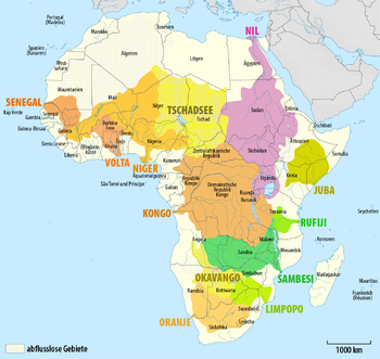
From the outer margin of the African plateaus, a large number of streams run to the sea with comparatively short courses, while the larger rivers flow for long distances on the interior highlands, before breaking through the outer ranges. The main drainage of the continent is to the north and west, or towards the basin of the Atlantic Ocean.

To the main African rivers belong: Nile (the longest river of Africa), Congo (river with the highest water discharge on the continent) and the Niger, which flows half of its length through the arid areas. The largest lakes are the following: Lake Victoria (Lake Ukerewe), Lake Chad, in the centre of the continent, Lake Tanganyika, lying between the Democratic Republic of Congo, Burundi, Tanzania and Zambia. There is also the considerably large Lake Malawi stretching along the eastern border of one of the poorest countries in the world -Malawi. There are also numerous water dams throughout the continent: Kariba on the river of Zambezi, Asuan in Egypt on the river of Nile and the biggest dam of the continent lying completely in The republic of Ghana is called Akosombo on the Volta river (Fobil 2003). The high lake plateau of the African Great Lakes region contains the headwaters of both the Nile and the Congo.

The break-up of Gondwana in Late Cretaceous and Cenozoic times led to a major reorganization of the river courses of various large African rivers including the Congo, Niger, Nile, Orange, Limpopo and Zambezi rivers.

Flowing to the Mediterranean Sea

The upper Nile receives its chief supplies from the mountainous region adjoining the Central African trough in the neighborhood of the equator. From there, streams pour eastward into Lake Victoria, the largest lake in Africa (covering over 26,000 square m.), and to the west and north into Lake Edward and Lake Albert. To the latter of these, the effluents of the other two lakes add their waters. Issuing from there, the Nile flows northward, and between the latitudes of 7 and 10 degrees north it traverses a vast marshy level, where its course is liable to being blocked by floating vegetation. After receiving the Bahr-el-Ghazal from the west and the Sobat, Blue Nile and Atbara from the Ethiopian Highlands (the chief gathering ground of the flood-water), it separates the great desert with its fertile watershed, and enters the Mediterranean at a vast delta.

Flowing to the Atlantic Ocean

The most remote head-stream of the Congo is the Chambezi, which flows southwest into the marshy Lake Bangweulu. From this lake issues the Congo, known in its upper course by various names. Flowing first south, it afterwards turns north through Lake Mweru and descends to the forest-clad basin of west equatorial Africa. Traversing this in a majestic northward curve, and receiving vast supplies of water from many great tributaries, it finally turns southwest and cuts a way to the Atlantic Ocean through the western highlands. The area of the Congo basin is greater than that of any other river except the Amazon, while the African inland drainage area is greater than that of any continent but Asia, where the corresponding area is 1,000,000 km2 (390,000 sq mi).

West of Lake Chad is the basin of the Niger, the third major river of Africa. With its principal source in the far west, it reverses the direction of flow exhibited by the Nile and Congo, and ultimately flows into the Atlantic — a fact that eluded European geographers for many centuries. An important branch, however — the Benue—flows from the southeast.

These four river basins occupy the greater part of the lower plateaus of North and West Africa — the remainder consists of arid regions watered only by intermittent streams that do not reach the sea.

Of the remaining rivers of the Atlantic basin, the Orange, in the extreme south, brings the drainage from the Drakensberg on the opposite side of the continent, while the Kunene, Kwanza, Ogowe and Sanaga drain the west coastal highlands of the southern limb; the Volta, Komoe, Bandama, Gambia and Senegal the highlands of the western limb. North of the Senegal, for over 1,500 km (930 mi) of coast, the arid region reaches to the Atlantic. Farther north are the streams, with comparatively short courses, reaching the Atlantic and Mediterranean from the Atlas mountains.

Flowing to the Indian Ocean

Of the rivers flowing to the Indian Ocean, the only one draining any large part of the interior plateaus is the Zambezi, whose western branches rise in the western coastal highlands. The main stream has its rise in 11°21′3″ S 24°22′ E, at an elevation of 1,500 m (4,900 ft). It flows to the west and south for a considerable distance before turning eastward. All the largest tributaries, including the Shire, the outflow of Lake Nyasa, flow down the southern slopes of the band of high ground stretching across the continent from 10° to 12° S. In the southwest, the Zambezi system interlaces with that of the Taukhe (or Tioghe), from which it at times receives surplus water. The rest of the water of the Taukhe, known in its middle course as the Okavango, is lost in a system of swamps and saltpans that was formerly centred in Lake Ngami, now dried up.

Farther south, the Limpopo drains a portion of the interior plateau, but breaks through the bounding highlands on the side of the continent nearest its source. The Rovuma, Rufiji and Tana principally drain the outer slopes of the African Great Lakes highlands.

In the Horn region to the north, the Jubba and the Shebelle rivers begin in the Ethiopian Highlands. These rivers mainly flow southwards, with the Jubba emptying in the Indian Ocean. The Shebelle River reaches a point to the southwest. After that, it consists of swamps and dry reaches before finally disappearing in the desert terrain near the Jubba River. Another large stream, the Hawash, rising in the Ethiopian mountains, is lost in a saline depression near the Gulf of Aden.

Inland basins

Between the basins of the Atlantic and Indian Oceans, there is an area of inland drainage along the centre of the Ethiopian plateau, directed chiefly into the lakes in the Great Rift Valley. The largest river is the Omo, which, fed by the rains of the Ethiopian highlands, carries down a large body of water into Lake Rudolf. The rivers of Africa are generally obstructed either by bars at their mouths, or by cataracts at no great distance upstream. But when these obstacles have been overcome, the rivers and lakes afford a vast network of navigable waters.

North of the Congo basin, and separated from it by a broad undulation of the surface, is the basin of Lake Chad – a flat-shored, shallow lake filled principally by the Chari coming from the southeast.

Lakes

The principal lakes of Africa are situated in the African Great Lakes plateau. The lakes found within the Great Rift Valley have steep sides and are very deep. This is the case with the two largest of the type, Tanganyika and Nyasa, the latter with depths of 800 m (2,600 ft). 

Others, however, are shallow, and hardly reach the steep sides of the valleys in the dry season. Such are Lake Rukwa, in a subsidiary depression north of Nyasa, and Eiassi and Manyara in the system of the Great Rift Valley. Lakes of the broad type are of moderate depth, the deepest sounding in Lake Victoria being under 90 m (300 ft).

Besides the African Great Lakes, the principal lakes on the continent are: Lake Chad, in the northern inland watershed; Bangweulu and Mweru, traversed by the head-stream of the Congo; and Lake Mai-Ndombe and Ntomba (Mantumba), within the great bend of that river. All, except possibly Mweru, are more or less shallow, and Lake Chad appears to be drying up.

Divergent opinions have been held as to the mode of origin of the African Great Lakes, especially Tanganyika, which some geologists have considered to represent an old arm of the sea, dating from a time when the whole central Congo basin was under water; others holding that the lake water has accumulated in a depression caused by subsidence. The former view is based on the existence in the lake of organisms of a decidedly marine type. They include jellyfish, molluscs, prawns, crabs, etc.

Lake Country Area Depth Surface elevation
m ft
Chad


259 850
Mai-Ndombe


335 1,099
Turkana


381 1,250
Malawi


501 1,644
Albert


618 2,028
Tanganyika


800 2,600
Ngami


899 2,949
Mweru


914 2,999
Edward


916 3,005
Bangweulu


1,128 3,701
Victoria


1,134 3,720
Abaya


1,280 4,200
Kivu


1,472 4,829
Tana


1,734 5,689
Naivasha


1,870 6,140

Islands

With the exception of Madagascar, the African islands are small. Madagascar, with an area of 587,041 km2 (226,658 sq mi), is, after Greenland, New Guinea and Borneo, the fourth largest island on the Earth. It lies in the Indian Ocean, off the S.E. coast of the continent, from which it is separated by the deep Mozambique channel, 400 km (250 mi) wide at its narrowest point. Madagascar in its general structure, as in flora and fauna, forms a connecting link between Africa and southern Asia. East of Madagascar are the small islands of Mauritius and Réunion. There are also islands in the Gulf of Guinea on which lies the Republic of São Tomé and Príncipe (islands of São Tomé and Príncipe). Part of the Republic of Equatorial Guinea is lying on the island of Bioko (with the capital Malabo and the town of Lubu) and the island of Annobón. Socotra lies E.N.E. of Cape Guardafui. Off the north-west coast are the Canary and Cape Verde archipelagoes. which, like some small islands in the Gulf of Guinea, are of volcanic origin. The South Atlantic Islands of Saint Helena and Ascension are classed as Africa but are situated on the Mid-Atlantic Ridge half way to South America.

Climatic conditions

Africa mean annual temperature
 
Africa mean annual precipitation
 
Africa map of Köppen climate classification.
 
Lying almost entirely within the tropics, and equally to north and south of the equator, Africa does not show excessive variations of temperature.

Great heat is experienced in the lower plains and desert regions of North Africa, removed by the great width of the continent from the influence of the ocean, and here, too, the contrast between day and night, and between summer and winter, is greatest. (The rarity of the air and the great radiation during the night cause the temperature in the Sahara to fall occasionally to freezing point.)

Farther south, the heat is to some extent modified by the moisture brought from the ocean, and by the greater elevation of a large part of the surface, especially in East Africa, where the range of temperature is wider than in the Congo basin or on the Guinea coast.

In the extreme north and south the climate is a warm temperate one, the northern countries being on the whole hotter and drier than those in the southern zone; the south of the continent being narrower than the north, the influence of the surrounding ocean is more felt.

The most important climatic differences are due to variations in the amount of rainfall. The wide heated plains of the Sahara, and in a lesser degree the corresponding zone of the Kalahari in the south, have an exceedingly scanty rainfall, the winds which blow over them from the ocean losing part of their moisture as they pass over the outer highlands, and becoming constantly drier owing to the heating effects of the burning soil of the interior; while the scarcity of mountain ranges in the more central parts likewise tends to prevent condensation. In the inter-tropical zone of summer precipitation, the rainfall is greatest when the sun is vertical or soon after. It is therefore greatest of all near the equator, where the sun is twice vertical, and less in the direction of both tropics.

Vegetation in February and August
 
The rainfall zones are, however, somewhat deflected from a due west-to-east direction, the drier northern conditions extending southwards along the east coast, and those of the south northwards along the west. Within the equatorial zone certain areas, especially on the shores of the Gulf of Guinea and in the upper Nile basin, have an intensified rainfall, but this rarely approaches that of the rainiest regions of the world. The rainiest district in all Africa is a strip of coastland west of Mount Cameroon, where there is a mean annual rainfall of about 10,000 mm (394 in) as compared with a mean of 11,600 mm (457 in) at Cherrapunji, in Meghalaya, India.

The two distinct rainy seasons of the equatorial zone, where the sun is vertical at half-yearly intervals, become gradually merged into one in the direction of the tropics, where the sun is overhead but once. Snow falls on all the higher mountain ranges, and on the highest the climate is thoroughly Alpine.

The countries bordering the Sahara are much exposed to a very dry wind, full of fine particles of sand, blowing from the desert towards the sea. Known in Egypt as the khamsin, on the Mediterranean as the sirocco, it is called on the Guinea coast the harmattan. This wind is not invariably hot; its great dryness causes so much evaporation that cold is not infrequently the result. Similar dry winds blow from the Kalahari Desert in the south. On the eastern coast the monsoons of the Indian Ocean are regularly felt, and on the southeast hurricanes are occasionally experienced.

Health

The climate of Africa lends itself to certain environmental diseases, the most serious of which are: malaria, sleeping sickness and yellow fever. Malaria is the most deadly environmental disease in Africa. It is transmitted by a genus of mosquito (anopheles mosquito) native to Africa, and can be contracted over and over again. There is not yet a vaccine for malaria, which makes it difficult to prevent the disease from spreading in Africa. Recently, the dissemination of mosquito netting has helped lower the rate of malaria. 

Yellow fever is a disease also transmitted by mosquitoes native to Africa. Unlike malaria, it cannot be contracted more than once. Like chicken pox, it is a disease that tends to be severe the later in life a person contracts the disease.

Sleeping sickness, or African trypanosomiasis, is a disease that usually affects animals, but has been known to be fatal to some humans as well. It is transmitted by the tsetse fly and is found almost exclusively in Sub-Saharan Africa. This disease has had a significant impact on African development not because of its deadly nature, like Malaria, but because it has prevented Africans from pursuing agriculture (as the sleeping sickness would kill their livestock).

Extreme points

These are the points that are farther north, south, east or west than any other location on the continent.
Africa
Africa (mainland)
Westernmost Point (mainland) — Pointe des Almadies
The highest point in Africa is Mount Kilimanjaro, 5,891.8 m (19,330 ft) in Tanzania. The lowest point is Lake Asal, 153 m (502 ft) below sea level, in Djibouti.

Operator (computer programming)

From Wikipedia, the free encyclopedia https://en.wikipedia.org/wiki/Operator_(computer_programmin...