Search This Blog

Thursday, June 30, 2022

Urban design

From Wikipedia, the free encyclopedia

Monumental Axis, Brasília designed in 1960 by Oscar Niemeyer and Lúcio Costa

While many assume urban design is about the process of designing and shaping the physical features of cities, and regional spaces, it is also about social design and other larger scale issues. Linking the fields of architecture as well as planning to better organize physical space and community environments.

Some important focuses of urban design on this page include its historical impact, paradigm shifts, its interdisciplinary nature, and issues related to urban design.

Theory

Urban design deals with the larger scale of groups of buildings, infrastructure, streets, and public spaces, entire neighbourhoods and districts, and entire cities, with the goal of making urban environments that are equitable, beautiful, performative, and sustainable.

Urban design is an interdisciplinary field that utilizes the procedures and the elements of architecture and other related professions, including landscape design, urban planning, civil engineering, and municipal engineering. It borrows substantive and procedural knowledge from public administration, sociology, law, urban geography, urban economics and other related disciplines from the social and behavioral sciences, as well as from the natural sciences. In more recent times different sub-subfields of urban design have emerged such as strategic urban design, landscape urbanism, water-sensitive urban design, and sustainable urbanism. Urban design demands an understanding of a wide range of subjects from physical geography to social science, and an appreciation for disciplines, such as real estate development, urban economics, political economy, and social theory.

Urban designers work to create inclusive cities that protect the commons, ensure equal access to and distribution of public goods, and meet the needs of all residents, particularly women, people of color, and other marginalized populations. Through design interventions, urban designers work to revolutionize the way we conceptualize our social, political, and spatial systems as strategies to produce and reproduce a more equitable and innovative future.

Urban design is about making connections between people and places, movement and urban form, nature and the built fabric. Urban design draws together the many strands of place-making, environmental stewardship, social equity, and economic viability into the creation of places with distinct beauty and identity. Urban design draws these and other strands together, creating a vision for an area and then deploying the resources and skills needed to bring the vision to life.

Urban design theory deals primarily with the design and management of public space (i.e. the 'public environment', 'public realm' or 'public domain'), and the way public places are used and experienced. Public space includes the totality of spaces used freely on a day-to-day basis by the general public, such as streets, plazas, parks, and public infrastructure. Some aspects of privately owned spaces, such as building facades or domestic gardens, also contribute to public space and are therefore also considered by urban design theory. Important writers on urban design theory include Christopher Alexander, Peter Calthorpe, Gordon Cullen, Andres Duany, Jane Jacobs, Jan Gehl, Allan B. Jacobs, Kevin Lynch, Aldo Rossi, Colin Rowe, Robert Venturi, William H. Whyte, Camillo Sitte, Bill Hillier (Space syntax), and Elizabeth Plater-Zyberk.

History

Although contemporary professional use of the term 'urban design' dates from the mid-20th century, urban design as such has been practiced throughout history. Ancient examples of carefully planned and designed cities exist in Asia, Africa, Europe, and the Americas, and are particularly well known within Classical Chinese, Roman, and Greek cultures. Specifically, Hippodamus of Miletus was a famous ancient Greek architect and urban planner, and all around academic that is often considered to be a "father of European urban planning", and the namesake of the "Hippodamian plan", also known as the grid plan of a city layout.

European Medieval cities are often, and often erroneously, regarded as exemplars of undesigned or 'organic' city development. There are many examples of considered urban design in the Middle Ages. In England, many of the towns listed in the 9th-century Burghal Hidage were designed on a grid, examples including Southampton, Wareham, Dorset and Wallingford, Oxfordshire, having been rapidly created to provide a defensive network against Danish invaders. 12th century western Europe brought renewed focus on urbanisation as a means of stimulating economic growth and generating revenue. The burgage system dating from that time and its associated burgage plots brought a form of self-organising design to medieval towns. Rectangular grids were used in the Bastides of 13th and 14th century Gascony, and the new towns of England created in the same period.

Throughout history, the design of streets and deliberate configuration of public spaces with buildings have reflected contemporaneous social norms or philosophical and religious beliefs. Yet the link between designed urban space and the human mind appears to be bidirectional. Indeed, the reverse impact of urban structure upon human behaviour and upon thought is evidenced by both observational study and historical records. There are clear indications of impact through Renaissance urban design on the thought of Johannes Kepler and Galileo Galilei. Already René Descartes in his Discourse on the Method had attested to the impact Renaissance planned new towns had upon his own thought, and much evidence exists that the Renaissance streetscape was also the perceptual stimulus that had led to the development of coordinate geometry.

Early modern era

The beginnings of modern urban design in Europe are associated with the Renaissance but, especially, with the Age of Enlightenment. Spanish colonial cities were often planned, as were some towns settled by other imperial cultures. These sometimes embodied utopian ambitions as well as aims for functionality and good governance, as with James Oglethorpe's plan for Savannah, Georgia. In the Baroque period the design approaches developed in French formal gardens such as Versailles were extended into urban development and redevelopment. In this period, when modern professional specializations did not exist, urban design was undertaken by people with skills in areas as diverse as sculpture, architecture, garden design, surveying, astronomy, and military engineering. In the 18th and 19th centuries, urban design was perhaps most closely linked with surveyors engineers and architects. The increase in urban populations brought with it problems of epidemic disease, the response to which was a focus on public health, the rise in the UK of municipal engineering and the inclusion in British legislation of provisions such as minimum widths of street in relation to heights of buildings in order to ensure adequate light and ventilation.

Much of Frederick Law Olmsted's work was concerned with urban design, and the newly formed profession of landscape architecture also began to play a significant role in the late 19th century.

Modern urban design

Ebenezer Howard's influential 1902 diagram, illustrating urban growth through garden city "off-shoots"

In the 19th century, cities were industrializing and expanding at a tremendous rate. Private businesses largely dictated the pace and style of this development. The expansion created many hardships for the working poor and concern for public health increased. However, the laissez-faire style of government, in fashion for most of the Victorian era, was starting to give way to a New Liberalism. This gave more power to the public. The public wanted the government to provide citizens, especially factory workers, with healthier environments. Around 1900, modern urban design emerged from developing theories on how to mitigate the consequences of the industrial age.

The first modern urban planning theorist was Sir Ebenezer Howard. His ideas, although utopian, were adopted around the world because they were highly practical. He initiated the garden city movement in 1898 garden city movement. His garden cities were intended to be planned, self-contained communities surrounded by parks. Howard wanted the cities to be proportional with separate areas of residences, industry, and agriculture. Inspired by the Utopian novel Looking Backward and Henry George's work Progress and Poverty, Howard published his book Garden Cities of To-morrow in 1898. His work is an important reference in the history of urban planning. He envisioned the self-sufficient garden city to house 32,000 people on a site of 6,000 acres (2,428 ha). He planned on a concentric pattern with open spaces, public parks, and six radial boulevards, 120 ft (37 m) wide, extending from the center. When it reached full population, Howard wanted another garden city to be developed nearby. He envisaged a cluster of several garden cities as satellites of a central city of 50,000 people, linked by road and rail. His model for a garden city was first created at Letchworth and Welwyn Garden City in Hertfordshire. Howard's movement was extended by Sir Frederic Osborn to regional planning.

20th century

In the early 1900s, urban planning became professionalized. With input from utopian visionaries, civil engineers, and local councilors, new approaches to city design were developed for consideration by decision-makers such as elected officials. In 1899, the Town and Country Planning Association was founded. In 1909, the first academic course on urban planning was offered by the University of Liverpool. Urban planning was first officially embodied in the Housing and Town Planning Act of 1909 Howard's 'garden city' compelled local authorities to introduce a system where all housing construction conformed to specific building standards. In the United Kingdom following this Act, surveyor, civil engineers, architects, and lawyers began working together within local authorities. In 1910, Thomas Adams became the first Town Planning Inspector at the Local Government Board and began meeting with practitioners. In 1914, The Town Planning Institute was established. The first urban planning course in America wasn't established until 1924 at Harvard University. Professionals developed schemes for the development of land, transforming town planning into a new area of expertise.

In the 20th century, urban planning was changed by the automobile industry. Car-oriented design impacted the rise of 'urban design'. City layouts now revolved around roadways and traffic patterns.

In June 1928, the International Congresses of Modern Architecture (CIAM) was founded at the Chateau de la Sarraz in Switzerland, by a group of 28 European architects organized by Le Corbusier, Hélène de Mandrot, and Sigfried Giedion. The CIAM was one of many 20th century manifestos meant to advance the cause of "architecture as a social art".

Postwar

Team X was a group of architects and other invited participants who assembled starting in July 1953 at the 9th Congress of the International Congresses of Modern Architecture (CIAM) and created a schism within CIAM by challenging its doctrinaire approach to urbanism.

In 1956, the term "Urban design" was first used at a series of conferences hosted by Harvard University. The event provided a platform for Harvard's Urban Design program. The program also utilized the writings of famous urban planning thinkers: Gordon Cullen, Jane Jacobs, Kevin Lynch, and Christopher Alexander.

In 1961, Gordon Cullen published The Concise Townscape. He examined the traditional artistic approach to city design of theorists including Camillo Sitte, Barry Parker, and Raymond Unwin. Cullen also created the concept of 'serial vision'. It defined the urban landscape as a series of related spaces.

Jane Jacobs, urban design activist and author of The Death and Life of Great American Cities.

Also in 1961, Jane Jacobs published The Death and Life of Great American Cities. She critiqued the modernism of CIAM (International Congresses of Modern Architecture). Jacobs also claimed crime rates in publicly owned spaces were rising because of the Modernist approach of 'city in the park'. She argued instead for an 'eyes on the street' approach to town planning through the resurrection of main public space precedents (e.g. streets, squares).

In the same year, Kevin Lynch published The Image of the City. He was seminal to urban design, particularly with regards to the concept of legibility. He reduced urban design theory to five basic elements: paths, districts, edges, nodes, landmarks. He also made the use of mental maps to understand the city popular, rather than the two-dimensional physical master plans of the previous 50 years.

Other notable works:

The popularity of these works resulted in terms that become everyday language in the field of urban planning. Aldo Rossi introduced 'historicism' and 'collective memory' to urban design. Rossi also proposed a 'collage metaphor' to understand the collection of new and old forms within the same urban space. Peter Calthorpe developed a manifesto for sustainable urban living via medium-density living. He also designed a manual for building new settlements in his concept of Transit Oriented Development (TOD). Bill Hillier and Julienne Hanson introduced Space Syntax to predict how movement patterns in cities would contribute to urban vitality, anti-social behaviour, and economic success. 'Sustainability', 'livability', and 'high quality of urban components' also became commonplace in the field.

Current trends

Jakriborg, in Sweden, started in the late 1990s as a new urbanist eco-friendly new town near Malmö

Today, urban design seeks to create sustainable urban environments with long-lasting structures, buildings, and overall livability. Walkable urbanism is another approach to practice that is defined within the Charter of New Urbanism. It aims to reduce environmental impacts by altering the built environment to create smart cities that support sustainable transport. Compact urban neighborhoods encourage residents to drive less. These neighborhoods have significantly lower environmental impacts when compared to sprawling suburbs. To prevent urban sprawl, Circular flow land use management was introduced in Europe to promote sustainable land use patterns.

As a result of the recent New Classical Architecture movement, sustainable construction aims to develop smart growth, walkability, architectural tradition, and classical design. It contrasts with modernist and globally uniform architecture. In the 1980s, urban design began to oppose the increasing solitary housing estates and suburban sprawl. Managed Urbanisation with the view to making the urbanising process completely culturally and economically, and environmentally sustainable, and as a possible solution to the urban sprawl, Frank Reale has submitted an interesting concept of Expanding Nodular Development (E.N.D.) that integrates many urban designs and ecological principles, to design and build smaller rural hubs with high-grade connecting freeways, rather than adding more expensive infrastructure to existing big cities and the resulting congestion.

Paradigm shifts

Throughout the young existence of the Urban Design discipline, many paradigm shifts have occurred that have affected the trajectory of the field regarding theory and practice. These paradigm shifts cover multiple subject areas outside of the traditional design disciplines.

  • Team 10 - The first major paradigm shift was the formation of Team 10 out of CIAM, or the Congres Internationaux d’Architecture Moderne. They believed that Urban Design should introduce ideas of ‘Human Association’, which pivots the design focus from the individual patron to concentrating on the collective urban population.  
  • The Brundtland Report and Silent Spring - Another paradigm shift was the publication of the Brundtland Report and the book Silent Spring by Rachel Carson. These writings introduced the idea that human settlements could have detrimental impacts on ecological processes, as well as human health, which spurred a new era of environmental awareness in the field.  
  • The Planner's Triangle - The Planner's Triangle, created by Scott Cambell, emphasized three main conflicts in the planning process. This diagram exposed the complex relationships between  Economic Development, Environmental Protection, and Equity and Social Justice. For the first time, the concept of Equity and Social Justice was considered as equally important as Economic Development and Environmental Protection within the design process.
  • Death of Modernism (Demolition of Pruitt Igoe) - Pruitt Igoe was a spatial symbol and representation of Modernist theory regarding social housing. In its failure and demolition, these theories were put into question and many within the design field considered the era of Modernism to be dead.  
  • Neoliberalism & the election of Reagan - The election of President Reagan and the rise of Neoliberalism affected the Urban Design discipline because it shifted the planning process to emphasize capitalistic gains and spatial privatization. Inspired by the trickle-down approach of Reaganomics,  it was believed that the benefits of a capitalist emphasis within design would positively impact everyone. Conversely, this led to exclusionary design practices and to what many consider as “the death of public space”.
  • Right to the City - The spatial and political battle over our citizens' rights to the city has been an ongoing one. David Harvey, along with Dan Mitchell and Edward Soja, discussed rights to the city as a matter of shifting the historical thinking of how spatial matter was determined in a critical form. This change of thinking occurred in three forms: ontologically, sociologically, and the combination of this socio-spatial dialect. Together the aim shifted to be able to measure what matters in a socio-spatial context.  
  • Black Lives Matter (Ferguson) - The Black Lives Matter movement challenged design thinking because it emphasized the injustices and inequities suffered by people of color in urban space, as well as emphasized their right to public space without discrimination and brutality. It claims that minority groups lack certain spatial privileges and that this deficiency can result in matters of life and death. In order to reach an equitable state of urbanism, there needs to be equal identification of socio-economic lives within our urbanscapes.

New approaches

There have been many different theories and approaches applied to the practice of urban design.

New Urbanism is an approach that began in the 1980s as a place-making initiative to combat suburban sprawl. Its goal is to increase density by creating compact and complete towns and neighborhoods. The 10 principles of new urbanism are walkability, connectivity, mixed-use and diversity, mixed housing, quality architecture and urban design, traditional neighborhood structure, increased density, smart transportation, sustainability, and quality of life. New urbanism and the developments that it has created are sources of debates within the discipline, primarily with the landscape urbanist approach but also due to its reproduction of idyllic architectural tropes that do not respond to the context. Andres Duany, Elizabeth Plater-Zyberk, Peter Calthorpe, and Jeff Speck are all strongly associated with New Urbanism and its evolution over the years.

Landscape Urbanism is a theory that first surfaced in the 1990s, arguing that the city is constructed of interconnected and ecologically rich horizontal field conditions, rather than the arrangement of objects and buildings. Charles Waldheim, Mohsen Mostafavi, James Corner, and Richard Weller are closely associated with this theory. Landscape urbanism theorises sites, territories, ecosystems, networks, and infrastructures through landscape practice according to Corner, while applying a dynamic concept to cities as ecosystems that grow, shrink or change phases of development according to Waldheim.

Everyday Urbanism is a concept introduced by Margaret Crawford and influenced by Henry Lefebvre that describes the everyday lived experience shared by urban residents including commuting, working, relaxing, moving through city streets and sidewalks, shopping, buying, eating food, and running errands. Everyday urbanism is not concerned with aesthetic value. Instead, it introduces the idea of eliminating the distance between experts and ordinary users and forces designers and planners to contemplate a 'shift of power' and address social life from a direct and ordinary perspective.

Tactical Urbanism (also known as DIY Urbanism, Planning-by-Doing, Urban Acupuncture, or Urban Prototyping) is a city, organizational, or citizen-led approach to neighborhood-building that uses short-term, low-cost, and scalable interventions and policies to catalyze long term change.

Top-up Urbanism is the theory and implementation of two techniques in urban design: top-down and bottom-up. Top-down urbanism is when the design is implemented from the top of the hierarchy - normally the government or planning department. Bottom-up or grassroots urbanism begins with the people or the bottom of the hierarchy. Top-up means that both methods are used together to make a more participatory design, so it is sure to be comprehensive and well regarded in order to be as successful as possible.

Infrastructural Urbanism is the study of how the major investments that go into making infrastructural systems can be leveraged to be more sustainable for communities. Instead of the systems being solely about efficiency in both cost and production, infrastructural urbanism strives to utilize these investments to be more equitable for social and environmental issues as well. Linda Samuels is a designer investigating how to accomplish this change in infrastructure in what she calls "next-generation infrastructure" which is “multifunctional; public; visible; socially productive; locally specific, flexible, and adaptable; sensitive to the eco-economy; composed of design prototypes or demonstration projects; symbiotic; technologically smart; and developed collaboratively across disciplines and agencies.”

Sustainable Urbanism is the study from the 1990s of how a community can be beneficial for the ecosystem, the people, and the economy for which it is associated. It is based on Scott Campbell's planner's triangle which tries to find the balance between economy, equity, and the environment. Its main concept is to try and make cities as self-sufficient as possible while not damaging the ecosystem around them, today with an increased focus on climate stability. A key designer working with sustainable urbanism is Douglas Farr.

Feminist Urbanism is the study and critique of how the built environment affects genders differently because of patriarchal social and political structures in society. Typically, the people at the table making design decisions are men, so their conception about public space and the built environment relates to their life perspectives and experiences, which do not reflect the same experiences of women or children. Dolores Hayden is a scholar who has researched this topic from 1980 to the present day. Hayden's writing says, “when women, men, and children of all classes and races can identify the public domain as the place where they feel most comfortable as citizens, Americans will finally have homelike urban space.”

Educational Urbanism is an emerging discipline, at the crossroads of urban planning, educational planning, and pedagogy. An approach that tackles the notion that economic activities, the need for new skills at the workplace, and the spatial configuration of the workplace rely on the spatial reorientation in the design of educational spaces and the urban dimension of educational planning.

Black Urbanism is an approach in which black communities are active creators, innovators, and authors of the process of designing and creating the neighborhoods and spaces of the metropolitan areas they have done so much to help revive over the past half-century. The goal is not to build black cities for black people but to explore and develop the creative energy that exists in so-called black areas: that has the potential to contribute to the sustainable development of the whole city.

Debates in urbanism

Underlying the practice of urban design are the many theories about how to best design the city. Each theory makes a unique claim about how to effectively design thriving, sustainable urban environments. Debates over the efficacy of these approaches fill the urban design discourse. Landscape Urbanism and New Urbanism are commonly debated as distinct approaches to addressing suburban sprawl. While Landscape Urbanism proposes landscape as the basic building block of the city and embraces horizontality, flexibility, and adaptability, New Urbanism offers the neighborhood as the basic building block of the city and argues for increased density, mixed uses, and walkability. Opponents of Landscape Urbanism point out that most of its projects are urban parks, and as such, its application is limited. Opponents of New Urbanism claim that its preoccupation with traditional neighborhood structures is nostalgic, unimaginative, and culturally problematic. Everyday Urbanism argues for grassroots neighborhood improvements rather than master-planned, top-down interventions. Each theory elevates the roles of certain professions in the urban design process, further fueling the debate. In practice, urban designers often apply principles from many urban design theories. Emerging from the conversation is a universal acknowledgement of the importance of increased interdisciplinary collaboration in designing the modern city.

Urban design as an integrative profession

L'Enfant's plan for Washington DC
 
Gehl Architects' project for Brighton New Road employing shared space

Urban designers work with architects, landscape architects, transportation engineers, urban planners, and industrial designers to reshape the city. Cooperation with public agencies, authorities and the interests of nearby property owners is necessary to manage public spaces. Users often compete over the spaces and negotiate across a variety of spheres. Input is frequently needed from a wide range of stakeholders. This can lead to different levels of participation as defined in Arnstein's Ladder of Citizen Participation.

While there are some professionals who identify themselves specifically as urban designers, a majority have backgrounds in urban planning, architecture, or landscape architecture. Many collegiate programs incorporate urban design theory and design subjects into their curricula. There is an increasing number of university programs offering degrees in urban design at the post-graduate level.

Urban design considers:

  • Pedestrian zones
  • Incorporation of nature within a city
  • Aesthetics
  • Urban structure – arrangement and relation of business and people
  • Urban typology, density, and sustainability - spatial types and morphologies related to the intensity of use, consumption of resources, production, and maintenance of viable communities
  • Accessibility – safe and easy transportation
  • Legibility and wayfinding – accessible information about travel and destinations
  • Animation – Designing places to stimulate public activity
  • Function and fit – places support their varied intended uses
  • Complimentary mixed uses – Locating activities to allow constructive interaction between them
  • Character and meaning – Recognizing differences between places
  • Order and incident – Balancing consistency and variety in the urban environment
  • Continuity and change – Locating people in time and place, respecting heritage and contemporary culture
  • Civil society – people are free to interact as civic equals, important for building social capital
  • Participation/engagement – including people in the decision-making process can be done at many different scales.

Relationships with other related disciplines

The original urban design was thought to be separated from architecture and urban planning. Urban Design has developed to a certain extent, and comes from the foundation of engineering. In Anglo-Saxon countries, it is often considered as a branch under the architecture, urban planning, and landscape architecture and limited as the construction of the urban physical environment. However Urban Design is more integrated into the social science-based, cultural, economic, political, and other aspects. Not only focus on space and architectural group, but also look at the whole city from a broader and more holistic perspective to shape a better living environment. Compared to architecture, the spatial and temporal scale of Urban Design processing is much larger. It deals with neighborhoods, communities, and even the entire city.

The urban design education

Following the 1956 Urban Design conference, Harvard University established the first graduate program with urban design in its title, The Master of Architecture in Urban Design, although as a subject taught in universities its history in Europe is far older. Urban design programs explore the built environment from diverse disciplinary backgrounds and points of view. The pedagogically innovative combination of interdisciplinary studios, lecture courses, seminars, and independent study creates an intimate and engaging educational atmosphere in which students thrive and learn. Soon after in 1961, Washington University in St. Louis founded their Master of Urban Design program. Today, twenty urban design programs exist in the United States:

  • Andrews University, Berrien Springs, MI
  • Ball State University - Indianapolis, IN
  • Clemson University - Charleston, SC
  • Columbia University - New York, NY
  • City College of New York - New York, NY
  • Georgia Tech - Atlanta, GA
  • Harvard University - Cambridge, MA
  • Iowa State University - Ames, IA
  • New York Institute of Technology - New York, NY
  • Pratt - Brooklyn, NY
  • Savannah College of Art and Design - Savannah, GA
  • University of California - Berkeley, CA
  • University of Colorado Denver - Denver, CO
  • University of Maryland - College Park, MD
  • University of Miami - Miami, FL
  • University of Michigan - Ann Arbor, MI
  • University of Notre Dame - Notre Dame, IN
  • University of Pennsylvania - Philadelphia, PA
  • University of Texas - Austin, TX
  • Washington University in St. Louis - St. Louis, MO
  • University of North Carolina at Charlotte - Charlotte, NC

Issues

Protest banner during the Climate Change Camp 2007 at Heathrow Airport in London.

The field of urban design holds enormous potential for helping us address today's biggest challenges: an expanding population, mass urbanization, rising inequality, and climate change. In its practice as well as its theories, urban design attempts to tackle these pressing issues. As climate change progresses, urban design can mitigate the results of flooding, temperature changes, and increasingly detrimental storm impacts through a mindset of sustainability and resilience. In doing so, the urban design discipline attempts to create environments that are constructed with longevity in mind. Cities today must be designed to minimize resource consumption, waste generation, and pollution while also withstanding the unknown impacts of climate change. To be truly resilient, our cities need to be able to not just bounce back from a catastrophic climate event but to bounce forward to an improved state.

Another issue in this field is that it is often assumed that there are no mothers of planning and urban design. However, this is not the case, many women have made proactive contributions to the field, including the work of Mary Kingsbury Simkhovitch, Florence Kelley, and Lillian Wald, to name a few of whom were prominent leaders in the City Social movement. The City Social was a movement that steamed between the commonly known City Practical and City Beautiful movements. It was a movement that’s main concerns lay with the economic and social equalities regarding urban issues.

Justice is and will always be a key issue in urban design. As previously mentioned, past urban strategies have caused injustices within communities incapable of being remedied via simple means. As urban designers tackle the issue of justice, they often are required to look at the injustices of the past and must be careful not to overlook the nuances of race, place, and socioeconomic status in their design efforts. This includes ensuring reasonable access to basic services, transportation, and fighting against gentrification and the commodification of space for economic gain. Organizations such as the Divided Cities Initiatives at Washington University in St. Louis and the Just City Lab at Harvard work on promoting justice in urban design.

Until the 1970s, the design of towns and cities took little account of the needs of people with disabilities. At that time, disabled people began to form movements demanding recognition of their potential contribution if social obstacles were removed. Disabled people challenged the 'medical model' of disability which saw physical and mental problems as an individual 'tragedy' and people with disabilities as 'brave' for enduring them. They proposed instead a 'social model' which said that barriers to disabled people result from the design of the built environment and attitudes of able-bodied people. 'Access Groups' were established composed of people with disabilities who audited their local areas, checked planning applications, and made representations for improvements. The new profession of 'access officer' was established around that time to produce guidelines based on the recommendations of access groups and to oversee adaptations to existing buildings as well as to check on the accessibility of new proposals. Many local authorities now employ access officers who are regulated by the Access Association. A new chapter of the Building Regulations (Part M) was introduced in 1992. Although it was beneficial to have legislation on this issue the requirements were fairly minimal but continue to be improved with ongoing amendments. The Disability Discrimination Act 1995 continues to raise awareness and enforce action on disability issues in the urban environment.

Circles of Sustainability

From Wikipedia, the free encyclopedia
 
A Circles of Sustainability representation - in this case for Melbourne in 2011.
 
Johannesburg Profile, Level 2, 2013
 
São Paulo Profile, Level 1, 2012
 
Delhi Profile, Level 1, 2012
 
Hyderabad Urban Profile, Level 1, 2012
 
Port Moresby Profile, Level 2, 2013
 
Tehran Profile, Level 1, 2012

Circles of Sustainability is a method for understanding and assessing sustainability, and for managing projects directed towards socially sustainable outcomes. It is intended to handle 'seemingly intractable problems' such as outlined in sustainable development debates. The method is mostly used for cities and urban settlements. This project was abandoned in 2019 and many of the references including the projects website no longer exists.

The style of the charts themselves could be described as a mixture of radar chart and bar chart.

Outline

Circles of Sustainability, and its treatment of the social domains of ecology, economics, politics and culture, provides the empirical dimension of an approach called 'engaged theory'. Developing Circles of Sustainability is part of larger project called 'Circles of Social Life', using the same four-domain model to analyze questions of resilience, adaptation, security, reconciliation. It is also being used in relation to thematics such as 'Circles of Child Wellbeing' (with World Vision).

As evidenced by Rio+20 and the UN Habitat World Urban Forum in Napoli (2012) and Medellin (2014), sustainability assessment is on the global agenda. However, the more complex the problems, the less useful current sustainability assessment tools seem to be for assessing across different domains: economics, ecology, politics and culture. For example, the Triple Bottom Line approach tends to take the economy as its primary point of focus with the domain of the environmental as the key externality. Secondly, the one-dimensional quantitative basis of many such methods means that they have limited purchase on complex qualitative issues. Thirdly, the size, scope and sheer number of indicators included within many such methods means that they are often unwieldy and resist effective implementation. Fourthly, the restricted focus of current indicator sets means that they do not work across different organizational and social settings—corporations and other institutions, cities, and communities. Most indicator approaches, such as the Global Reporting Initiative or ISO14031, have been limited to large corporate organizations with easily definable legal and economic boundaries. Circles of Sustainability was developed to respond to those limitations.

History

The method began with a fundamental dissatisfaction with current approaches to sustainability and sustainable development, which tended to treat economics as the core domain and ecology as an externality. Two concurrent developments provided impetus: a major project in Porto Alegre, and a United Nations’ paper called Accounting for Sustainability, Briefing Paper, No. 1, 2008. The researchers developed a method and an integrated set of tools for assessing and monitoring issues of sustainability while providing guidance for project development. The method was then further refined through projects in Melbourne and Milwaukee, and through an ARC-funded cross-disciplinary project that partnered with various organizations including Microsoft Australia, Fuji Xerox Australia, the City of Melbourne, World Vision, UN-Habitat and most crucially Metropolis. In Canada, the Green Score City Index was inspired by studying the UN circle of sustainability. However, unlike this system, the Canadian index data-sets are focused on measuring the physical footprints of human activity and greenspace footprints which are less subjectivity than cultural and economic indicators.

Use of the method

The method is used by a series of global organizations including the United Nations Global Compact Cities Programme, The World Association of Major Metropolises, and World Vision to support their engagement in cities. It is also used by a number of cities across the world in different ways to manage major projects or to provide feedback on their sustainability profiles (e.g., Hyderabad, Johannesburg, Melbourne, New Delhi, São Paulo and Tehran). It is a method for understanding urban politics and urban planning, as well as for conducting sustainability analysis and profiling sustainable development.

Global Compact Cities Programme

The methodology is made available by UN Global Compact Cities Programme for its engagement with its more than 80 Signatory Cities. In particular, some of the 14 Innovating Cities in the programme have influenced the development of the Circles of Sustainability method through their management of major projects, some with intensity and others as a background feature. They use a cross-sectoral and holistic approach for developing a response to self-defined seemingly intractable problems.

Porto Alegre, Vila Chocolatão project

The Vila Chocolatão project refers to the 2011 resettlement of approximately 1,000 residents of the inner-city Vila Chocolatão slum in Porto Alegre, Brazil. The resettlement project of Vila Chocolatão commenced in 2000 in response to an imminent eviction of the community, with community members seeking resources and support to resettle through the city of Porto Alegre's renown participatory budgeting system. The lengthy preparation to resettle was led by a local cross-sectoral network group, the Vila Chocolatão Sustainability Network. The group was initially instigated by the Regional Court, TRF4 and consisted of the Vila Chocolatão Residents Association, local government departments, federal agencies, non-government organisations and the corporate sector. The project was supported by the City of Porto Alegre through the municipality’s Local Solidarity Governance Scheme. In 2006, the Vila Chocolatao resettlement project was recognised as a pilot project for the then new Cities Programme cross-sectoral model with City Hall assembling a Critical Reference Group to identify critical issues and joint solutions to those issues involved in the resettlement.

This long-standing collaborative project has been successful in rehousing a whole community of slum dwellers, it has also effected a restructuring of how the city approaches slums. The project ensured sustainability was built into the relocation through changes such as setting up of recycling depots next to existing slums and developing a formal recycling sorting facility in the new site, Residencial Nova Chocolatão, linked to the garbage-collection process of the city (an example of linking the sub-domains of ‘emission and waste’ and ‘organization and governance’); and establishing a fully resourced early childhood centre in the new community. The Vila Chocolatão Sustainability Network group continues to meet and work with the community post the resettlement. This network-led model is now being utilized by the City of Porto Alegre with other informal settlements.

Milwaukee, water sustainability project

In 2009, Milwaukee, Wisconsin, United States of America, wanted to address the issue of water quality in the city. The Circles of Sustainability methodology became the basis for an integrated city project. In the period of the application of the method (2009–present) there has been a rediscovery of the value of water from an industry and broader community perspective.

In 2011, Milwaukee won the United States Water Prize given by the Clean Water America Alliance, as well as a prize from IBM Better Cities program worth $500,000. The community has also attracted some leading water treatment innovators and is establishing a graduate School of Freshwater Sciences at the University of Wisconsin-Milwaukee.

Metropolis (World Association of the Major Metropolises)

The methodology was first used by Metropolis for Commission 2, 2012, Managing Urban Growth. This Commission, which met across the period 2009–2011, was asked to make recommendations for use by Metropolis’s 120 member cities on the theme of managing growth. The Commission Report using the Circles of Sustainability methodology was published on the web in three languages—English, French and Spanish—and is used by member cities as a guide to practice.

In 2011, the research team were invited by Metropolis to work with the Victorian Government and the Cities Programme on one of their major initiatives. The methodology is central to the approach used by the ‘Integrated Strategic Planning and Public-Private Partnerships Initiative’ organized by Metropolis, 2012–2013 for Indian, Brazilian and Iranian cities. A workshop was held in New Delhi, 26–27 July 2012, and senior planners from New Delhi, Hyderabad and Kolkata used the two of the assessment tools in the Circles of Sustainability toolbox to map the sustainability of their cities as part of developing their urban-regional plans. Other cities to use the same tools have been Tehran (in relation to their mega-projects plan) and São Paulo (in relation to their macro-metropolitan plan).

Since 2012, the Cities Programme and Metropolis have worked together to refine the 'Circles of Sustainability' method to use with their respective member cities. A Metropolis Taskforce was charged with further developing the method.

The Economist

In 2011, The Economist invited Paul James (Director of the United Nations Global Compact Cities Programme) and Chetan Vedya (Director, National Institute of Urban Affairs, India) into a debate around the question of urban sustainability and metropolitan growth. It led to over 200 letters to the editor in direct response as well as numerous linked citations on other websites.

World Vision

In 2011, recognising how much the two processes of urbanization and globalization were changing the landscape of poverty, World Vision decided to shift its orientation towards urban settings. Previously 80 per cent of its projects had been in small rural communities. The Circles of Sustainability method now underpins that reorientation and pilot studies are being conducted in India, South Africa, Lebanon, Indonesia and elsewhere, to refine the methodology for aid delivery in complex urban settings.

Domains and subdomains

The Circles of Sustainability approach is explicitly critical of other domain models such as the triple bottom line that treat economics as if it is outside the social, or that treat the environment as an externality. It uses a four-domain model - economics, ecology, politics and culture. In each of these domains there are 7 subdomains.

Economics

The economic domain is defined as the practices and meanings associated with the production, use, and management of resources, where the concept of ‘resources’ is used in the broadest sense of that word.

  1. Production and resourcing
  2. Exchange and transfer
  3. Accounting and regulation
  4. Consumption and use
  5. Labour and welfare
  6. Technology and infrastructure
  7. Wealth and distribution

Ecology

The ecological domain is defined as the practices and meanings that occur across the intersection between the social and the natural realms, focusing on the important dimension of human engagement with and within nature, but also including the built-environment.

  1. Materials and energy
  2. Water and air
  3. Flora and fauna
  4. Habitat and settlements
  5. Built-form and transport
  6. Embodiment and sustenance
  7. Emission and waste

Politics

The political is defined as the practices and meanings associated with basic issues of social power, such as organization, authorization, legitimation and regulation. The parameters of this area extend beyond the conventional sense of politics to include not only issues of public and private governance but more broadly social relations in general.

  1. Organization and governance
  2. Law and justice
  3. Communication and critique
  4. Representation and negotiation
  5. Security and accord
  6. Dialogue and reconciliation
  7. Ethics and accountability

Culture

The cultural domain is defined as the practices, discourses, and material expressions, which, over time, express continuities and discontinuities of social meaning.

  1. Identity and engagement
  2. Creativity and recreation
  3. Memory and projection
  4. Belief and ideas
  5. Gender and generations
  6. Enquiry and learning
  7. Wellbeing and health

Effects of climate change on ecosystems

Rainforest ecosystems are rich in biodiversity. This is the Gambia River in Senegal's Niokolo-Koba National Park.

Climate change has adversely affected both terrestrial and marine ecosystems, and is expected to further affect many ecosystems, including tundra, mangroves, coral reefs, and caves. Increasing global temperature, more frequent occurrence of extreme weather, and rising sea level are among some of the effects of climate change that will have the most significant impact. Some of the possible consequences of these effects include species decline and extinction, behavior change within ecosystems, increased prevalence of invasive species, a shift from forests being carbon sinks to carbon sources, ocean acidification, disruption of the water cycle, and increased occurrence of natural disasters, among others.

General

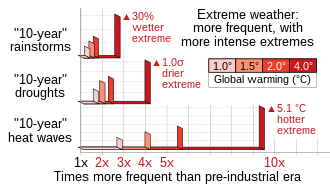
The IPCC Sixth Assessment Report (2021) projects progressively large increases in both the frequency (horizontal bars) and intensity (vertical bars) of extreme weather events, for increasing degrees of global warming.

Climate change is affecting terrestrial ecoregions. Increasing global temperature means that ecosystems are changing; some species are being forced out of their habitats (possibly to extinction) because of changing conditions, while others are flourishing. Other effects of global warming include lessened snow cover, rising sea levels, and weather changes, may influence human activities and the ecosystem.

Within the IPCC Fourth Assessment Report, experts assessed the literature on the impacts of climate change on ecosystems. Rosenzweig et al. (2007) concluded that over the last three decades, human-induced warming had likely had a discernible influence on many physical and biological systems (p. 81). Schneider et al. (2007) concluded, with very high confidence, that regional temperature trends had already affected species and ecosystems around the world (p. 792). They also concluded that climate change would result in the extinction of many species and a reduction in the diversity of ecosystems (p. 792).

  • Terrestrial ecosystems and biodiversity: With a warming of 3 °C, relative to 1990 levels, it is likely that global terrestrial vegetation would become a net source of carbon (Schneider et al., 2007:792). With high confidence, Schneider et al. (2007:788) concluded that a global mean temperature increase of around 4 °C (above the 1990-2000 level) by 2100 would lead to major extinctions around the globe.
  • Marine ecosystems and biodiversity: With very high confidence, Schneider et al. (2007:792) concluded that a warming of 2 °C above 1990 levels would result in mass mortality of coral reefs globally. In addition, several studies dealing with planktonic organisms and modelling have shown that temperature plays a transcendental role in marine microbial food webs, which may have a deep influence on the biological carbon pump of marine planktonic pelagic and mesopelagic ecosystems.
  • Freshwater ecosystems: Above about a 4 °C increase in global mean temperature by 2100 (relative to 1990–2000), Schneider et al. (2007:789) concluded, with high confidence, that many freshwater species would become extinct.

Biodiversity

Extinction

Studying the association between Earth climate and extinctions over the past 520 million years, scientists from the University of York write, "The global temperatures predicted for the coming centuries may trigger a new ‘mass extinction event’, where over 50 percent of animal and plant species would be wiped out."

Many of the species at risk are Arctic and Antarctic fauna such as polar bears and emperor penguins. In the Arctic, the waters of Hudson Bay are ice-free for three weeks longer than they were thirty years ago, affecting polar bears, which prefer to hunt on sea ice. Species that rely on cold weather conditions such as gyrfalcons, and snowy owls that prey on lemmings that use the cold winter to their advantage may be negatively affected. Marine invertebrates achieve peak growth at the temperatures they have adapted to, and cold-blooded animals found at high latitudes and altitudes generally grow faster to compensate for the short growing season. Warmer-than-ideal conditions result in higher metabolism and consequent reductions in body size despite increased foraging, which in turn elevates the risk of predation. Indeed, even a slight increase in temperature during development impairs growth efficiency and survival rate in rainbow trout.

Mechanistic studies have documented extinctions due to recent climate change: McLaughlin et al. documented two populations of Bay checkerspot butterfly being threatened by precipitation change. Parmesan states, "Few studies have been conducted at a scale that encompasses an entire species" and McLaughlin et al. agreed "few mechanistic studies have linked extinctions to recent climate change." Daniel Botkin and other authors in one study believe that projected rates of extinction are overestimated. For "recent" extinctions, see Holocene extinction.

Many species of freshwater and saltwater plants and animals are dependent on glacier-fed waters to ensure a cold water habitat that they have adapted to. Some species of freshwater fish need cold water to survive and to reproduce, and this is especially true with salmon and cutthroat trout. Reduced glacier runoff can lead to insufficient stream flow to allow these species to thrive. Ocean krill, a cornerstone species, prefer cold water and are the primary food source for aquatic mammals such as the blue whale. Alterations to the ocean currents, due to increased freshwater inputs from glacier melt, and the potential alterations to thermohaline circulation of the worlds oceans, may affect existing fisheries upon which humans depend as well.

The white lemuroid possum, only found in the Daintree mountain forests of northern Queensland, may be the first mammal species to be driven extinct by global warming in Australia. In 2008, the white possum has not been seen in over three years. The possums cannot survive extended temperatures over 30 °C (86 °F), which occurred in 2005.

A 27-year study of the largest colony of Magellanic penguins in the world, published in 2014, found that extreme weather caused by climate change is responsible for killing 7% of penguin chicks per year on average, and in some years studied climate change accounted for up to 50% of all chick deaths. Since 1987, the number of breeding pairs in the colony has reduced by 24%.

Furthermore, climate change may disrupt ecological partnerships among interacting species, via changes on behaviour and phenology, or via climate niche mismatch. The disruption of species-species associations is a potential consequence of climate-driven movements of each individual species towards opposite directions. Climate change may, thus, lead to another extinction, more silent and mostly overlooked: the extinction of species' interactions. As a consequence of the spatial decoupling of species-species associations, ecosystem services derived from biotic interactions are also at risk from climate niche mismatch.

Behaviour change

Rising temperatures are beginning to have a noticeable impact on birds, and butterflies have shifted their ranges northward by 200 km in Europe and North America. The migration range of larger animals may be constrained by human development. In Britain, spring butterflies are appearing an average of 6 days earlier than two decades ago.

A 2002 article in Nature surveyed the scientific literature to find recent changes in range or seasonal behaviour by plant and animal species. Of species showing recent change, 4 out of 5 shifted their ranges towards the poles or higher altitudes, creating "refugee species". Frogs were breeding, flowers blossoming and birds migrating an average 2.3 days earlier each decade; butterflies, birds and plants moving towards the poles by 6.1 km per decade. A 2005 study concludes human activity is the cause of the temperature rise and resultant changing species behaviour, and links these effects with the predictions of climate models to provide validation for them. Scientists have observed that Antarctic hair grass is colonizing areas of Antarctica where previously their survival range was limited.

Climate change is leading to a mismatch between the snow camouflage of arctic animals such as snowshoe hares with the increasingly snow-free landscape.

Invasive species

Buffelgrass (Cenchrus ciliaris) is an invasive species throughout the world that is pushing out native species.

Climate change and invasive species is the destabilization of the environment caused by climate change that is facilitating the spread of invasive species.

Anthropocentric climate change has been found to bring about the increase in temperature and precipitation in a range of ecosystems. The drastic change of these climate factors is predicted to progress leading to the destabilization of ecosystems. Human-caused climate change and the rise in invasive species are directly linked through changing of ecosystems. The destabilization of climate factors in these ecosystems can lead to the creation of a more hospitable habitat for invasive species- species that not historically found in the impacted regions. Thus, invasive species are able to spread beyond their original boundaries. This relationship is notable because climate change and invasive species are also considered by the USDA to be two of the top four causes of global biodiversity loss.

Forests

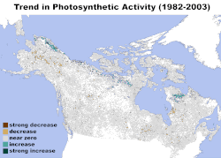
Change in Photosynthetic Activity in Northern Forests 1982–2003; NASA Earth Observatory
 

As the northern forests are a carbon sink, while dead forests are a major carbon source, the loss of such large areas of forest has a positive feedback on global warming. In the worst years, the carbon emission due to beetle infestation of forests in British Columbia alone approaches that of an average year of forest fires in all of Canada or five years worth of emissions from that country's transportation sources.

Research suggests that slow-growing trees only are stimulated in growth for a short period under higher CO2 levels, while faster growing plants like liana benefit in the long term. In general, but especially in rainforests, this means that liana become the prevalent species; and because they decompose much faster than trees their carbon content is more quickly returned to the atmosphere. Slow growing trees incorporate atmospheric carbon for decades.

Wildfires

Healthy and unhealthy forests appear to face an increased risk of forest fires because of the warming climate. The 10-year average of boreal forest burned in North America, after several decades of around 10,000 km2 (2.5 million acres), has increased steadily since 1970 to more than 28,000 km2 (7 million acres) annually. Though this change may be due in part to changes in forest management practices, in the western U.S., since 1986, longer, warmer summers have resulted in a fourfold increase of major wildfires and a sixfold increase in the area of forest burned, compared to the period from 1970 to 1986. A similar increase in wildfire activity has been reported in Canada from 1920 to 1999.

Forest fires in Indonesia have dramatically increased since 1997 as well. These fires are often actively started to clear forest for agriculture. They can set fire to the large peat bogs in the region and the CO₂ released by these peat bog fires has been estimated, in an average year, to be 15% of the quantity of CO₂ produced by fossil fuel combustion.

A 2018 study found that trees grow faster due to increased carbon dioxide levels, however, the trees are also eight to twelve percent lighter and denser since 1900. The authors note, "Even though a greater volume of wood is being produced today, it now contains less material than just a few decades ago."

The Arctic region, is particularly sensitive and warming faster than most other regions. Particles of smoke can land on snow and ice, causing them to absorb sunlight that it would otherwise reflect, accelerating the warming. Fires in the Arctic also increase the risk of permafrost thawing that releases methane - strong greenhouse gas. Improving forecasting systems is important to solve the problem. In view of the risks, WMO has created a Vegetation Fire and Smoke Pollution Warning and Advisory System for forecasting fires and related impacts and hazards across the globe. WMO's Global Atmosphere Watch Programme has released a short video about the issue.

Invasive species in forests

An invasive species is any kind of living organism that is not native to an ecosystem that adversely affects it. These negative effects can include the extinction of native plants or animals, biodiversity destruction, and permanent habitat alteration.

Pine forests in British Columbia have been devastated by a pine beetle infestation, which has expanded unhindered since 1998 at least in part due to the lack of severe winters since that time; a few days of extreme cold kill most mountain pine beetles and have kept outbreaks in the past naturally contained. The infestation, which (by November 2008) has killed about half of the province's lodgepole pines (33 million acres or 135,000 km2) is an order of magnitude larger than any previously recorded outbreak. One reason for unprecedented host tree mortality may be due to that the mountain pine beetles have higher reproductive success in lodgepole pine trees growing in areas where the trees have not experienced frequent beetle epidemics, which includes much of the current outbreak area. In 2007 the outbreak spread, via unusually strong winds, over the continental divide to Alberta. An epidemic also started, be it at a lower rate, in 1999 in Colorado, Wyoming, and Montana. The United States forest service predicts that between 2011 and 2013 virtually all 5 million acres (20,000 km2) of Colorado's lodgepole pine trees over five inches (127 mm) in diameter will be lost.

Taiga

Climate change is having a disproportionate impact on boreal forests, which are warming at a faster rate than the global average. leading to drier conditions in the Taiga, which leads to a whole host of subsequent issues. Climate change has a direct impact on the productivity of the boreal forest, as well as health and regeneration. As a result of the rapidly changing climate, trees are migrating to higher latitudes and altitudes (northward), but some species may not be migrating fast enough to follow their climatic habitat. Moreover, trees within the southern limit of their range may begin to show declines in growth. Drier conditions are also leading to a shift from conifers to aspen in more fire and drought-prone areas.

Assisted migration

Assisted migration, the act of moving plants or animals to a different habitat, has been proposed as a solution to the above problem. For species that may not be able to disperse easily, have long generation times or have small populations, this form of adaptative management and human intervention may help them survive in this rapidly changing climate.

The assisted migration of North American forests has been discussed and debated by the science community for decades. In the late 2000s and early 2010s, the Canadian provinces of Alberta and British Columbia finally acted and modified their tree reseeding guidelines to account for the northward movement of forest's optimal ranges. British Columbia even gave the green light for the relocation of a single species, the western larch, 1000 km northward.

Mountain pine beetle and forest fires

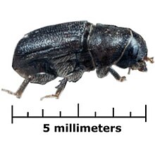
Adult mountain pine beetle

Climate change and the associated changing weather patterns occurring worldwide have a direct effect on biology, population ecology, and the population of eruptive insects, such as the mountain pine beetle (MPB). This is because temperature is a factor which determines insect development and population success. Mountain Pine Beetle are a species native to Western North America. Prior to climatic and temperature changes, the mountain pine beetle predominately lived and attacked lodgepole and ponderosa pine trees at lower elevations, as the higher elevation Rocky Mountains and Cascades were too cold for their survival. Under normal seasonal freezing weather conditions in the lower elevations, the forest ecosystems that pine beetles inhabit are kept in a balance by factors such as tree defense mechanisms, beetle defense mechanisms, and freezing temperatures. It is a simple relationship between a host (the forest), an agent (the beetle) and the environment (the weather & temperature). However, as climate change causes mountain areas to become warmer and drier, pine beetles have more power to infest and destroy the forest ecosystems, such as the whitebark pine forests of the Rockies. This is a forest so important to forest ecosystems that it is called the “rooftop of the rockies”. Climate change has led to a threatening pine beetle pandemic, causing them to spread far beyond their native habitat. This leads to ecosystem changes, forest fires, floods and hazards to human health.

The whitebark pine ecosystem in these high elevations plays many essential roles, providing support to plant and animal life. They provide food for grizzly bears and squirrels, as well as shelter and breeding grounds for elk and deer; protects watersheds by sending water to parched foothills and plains; serves as a reservoir by dispensing supplies of water from melted snowpacks that are trapped beneath the shaded areas; and creates new soil which allows for growth of other trees and plant species. Without these pines, animals do not have adequate food, water, or shelter, and the reproductive life cycle, as well as quality of life, is affected as a consequence. Normally, the pine beetle cannot survive in these frigid temperatures and high elevation of the Rocky Mountains. However, warmer temperatures means that the pine beetle can now survive and attack these forests, as it no longer is cold enough to freeze and kill the beetle at such elevations. Increased temperatures also allow the pine beetle to increase their life cycle by 100%: it only takes a single year instead of two for the pine beetle to develop. As the Rockies have not adapted to deal with pine beetle infestations, they lack the defenses to fight the beetles. Warmer weather patterns, drought, and beetle defense mechanisms together dries out sap in pine trees, which is the main mechanism of defense that trees have against the beetle, as it drowns the beetles and their eggs. This makes it easier for the beetle to infest and release chemicals into the tree, luring other beetles in an attempt to overcome the weakened defense system of the pine tree. As a consequence, the host (forest) becomes more vulnerable to the disease-causing agent (the beetle).

The whitebark forests of the Rockies are not the only forests that have been affected by the mountain pine beetle. Due to temperature changes and wind patterns, the pine beetle has now spread through the Continental Divide of the Rockies and has invaded the fragile boreal forests of Alberta, known as the “lungs of the Earth”. These forests are imperative for producing oxygen through photosynthesis and removing carbon in the atmosphere. But as the forests become infested and die, carbon dioxide is released into the environment, and contributes even more to a warming climate. Ecosystems and humans rely on the supply of oxygen in the environment, and threats to this boreal forest results in severe consequences to our planet and human health. In a forest ravaged by pine beetle, the dead logs and kindle which can easily be ignited by lightning. Forest fires present dangers to the environment, human health and the economy. They are detrimental to air quality and vegetation, releasing toxic and carcinogenic compounds as they burn. Due to human induced deforestation and climate change, along with the pine beetle pandemic, the strength of forest ecosystems decrease. The infestations and resulting diseases can indirectly, but seriously, effect human health. As droughts and temperature increases continue, so does the frequency of devastating forest fires, insect infestations, forest diebacks, acid rain, habitat loss, animal endangerment and threats to safe drinking water.

Mountain habitats

Mountains cover approximately 25 percent of earth's surface and provide a home to more than one-tenth of global human population. Changes in global climate pose a number of potential risks to mountain habitats. Researchers expect that over time, climate change will affect mountain and lowland ecosystems, the frequency and intensity of forest fires, the diversity of wildlife, and the distribution of fresh water.

Studies suggest a warmer climate would cause lower-elevation habitats to expand into the higher alpine zone. Such a shift would encroach on rare alpine meadows and other high-altitude habitats. High-elevation plants and animals have limited space available for new habitat as they move higher on the mountains in order to adapt to long-term changes in regional climate. Such uphill shifts of both ranges and abundances have been recorded for various groups of species across the world.

Changes in climate are melting glaciers and reducing the depth of the mountain snowpacks. Any changes in their seasonal melting can have powerful impacts on areas that rely on freshwater runoff from mountains. Rising temperature may cause snow to melt earlier and faster in the spring and shift the timing and distribution of runoff. These changes could affect the availability of freshwater for natural systems and human uses.

Marine ecosystems

Diagram with some effects of climate change on oceans.

The effects of climate change on oceans include the rise in sea level from ocean warming and ice sheet melting, and changes in pH value (ocean acidification), circulation, and stratification due to changing temperatures leading to changes in oxygen concentrations. There is clear evidence that the Earth is warming due to anthropogenic emissions of greenhouse gases and leading inevitably to ocean warming. The greenhouse gases taken up by the ocean (via carbon sequestration) help to mitigate climate change but lead to ocean acidification.

Physical effects of climate change on oceans include sea level rise which will in particular affect coastal areas, ocean currents, weather and the seafloor. Chemical effects include ocean acidification and reductions in oxygen levels. Furthermore, there will be effects on marine life. The consensus of many studies of coastal tide gauge records is that during the past century sea level has risen worldwide at an average rate of 1–2 mm/yr reflecting a net flux of heat into the surface of the land and oceans. The rate at which ocean acidification will occur may be influenced by the rate of surface ocean warming, because the chemical equilibria that govern seawater pH are temperature-dependent. Increase of water temperature will also have a devastating effect on different oceanic ecosystems like coral reefs. The direct effect is the coral bleaching of these reefs, which live within a narrow temperature margin, so a small increase in temperature would have a drastic effects in these environments.

Freshwater ecosystems

Salt water contamination and cool water species

Eagle River in central Alaska, home to various indigenous freshwater species.

Species of fish living in cold or cool water can see a reduction in population of up to 50% in the majority of U.S. fresh water streams, according to most climate change models. The increase in metabolic demands due to higher water temperatures, in combination with decreasing amounts of food will be the main contributors to their decline. Additionally, many fish species (such as salmon) utilize seasonal water levels of streams as a means of reproducing, typically breeding when water flow is high and migrating to the ocean after spawning. Because snowfall is expected to be reduced due to climate change, water runoff is expected to decrease which leads to lower flowing streams, effecting the spawning of millions of salmon. To add to this, rising seas will begin to flood coastal river systems, converting them from fresh water habitats to saline environments where indigenous species will likely perish. In southeast Alaska, the sea rises by 3.96 cm/year, redepositing sediment in various river channels and bringing salt water inland. This rise in sea level not only contaminates streams and rivers with saline water, but also the reservoirs they are connected to, where species such as Sockeye Salmon live. Although this species of Salmon can survive in both salt and fresh water, the loss of a body of fresh water stops them from reproducing in the spring, as the spawning process requires fresh water. Undoubtedly, the loss of fresh water systems of lakes and rivers in Alaska will result in the imminent demise of the state's once-abundant population of salmon.

Species migration

In the Arctic, the prevalent rise of CO2 and temperatures are changing the tundra plants and other xerophytic shrub composition in the ecosystem. For example, in the Siberian subarctic, species migration is contributing to another warming albedo-feedback, as needle-shedding larch trees are being replaced with dark-foliage evergreen conifers which can absorb some of the solar radiation that previously reflected off the snowpack beneath the forest canopy. It has been projected many fish species will migrate towards the North and South poles as a result of climate change, and that many species of fish near the Equator will go extinct as a result of global warming.

Migratory birds are especially at risk for endangerment due to the extreme dependability on temperature and air pressure for migration, foraging, growth, and reproduction. Much research has been done on the effects of climate change on birds, both for future predictions and for conservation. The species said to be most at risk for endangerment or extinction are populations that are not of conservation concern. It is predicted that a 3.5 degree increase in surface temperature will occur by year 2100, which could result in between 600 and 900 extinctions, which mainly will occur in the tropical environments.

Species adaptation

A young red deer in the wild in Scotland.

Climate change has affected the gene pool of the red deer population on Rùm, one of the Inner Hebrides islands, Scotland. Warmer temperatures resulted in deer giving birth on average three days earlier for each decade of the study. The gene which selects for earlier birth has increased in the population because those with the gene have more calves over their lifetime.

A study in Chicago showed that the length of birds' lower leg bones (an indicator of body sizes) shortened by an average of 2.4% and their wings lengthened by 1.3%. A study from central Amazon showed that birds have decreased in mass (an indicator of size) by up to 2% per decade, and increased in wing length by up to 1% per decade, with links to temperature and precipitation shifts. The findings of these studies suggest the morphological changes are the result of climate change, and may demonstrate an example of evolutionary change following Bergmann's rule.

The Jutfelt Fish Ecophysiology lab at the Norwegian University of Science and Technology (NTNU), under their director professor Fredrik Jutfelt, investigates how evolution can lead to physiological adaptation to the temperature environment where the fish live. They recently performed a large artificial selection experiment, published in Proceedings of the National Academy of Sciences of the United States of America (PNAS), showing that evolution of tolerance to warming can occur in fish. The rate of evolution, however, was suggested to be too slow for evolutionary rescue to protect fish from the impacts of climate change.

Impacts of species degradation due to climate change on livelihoods

The livelihoods of nature dependent communities depend on abundance and availability of certain species. Climate change conditions such as increase in atmospheric temperature and carbon dioxide concentration directly affect availability of biomass energy, food, fiber and other ecosystem services. Degradation of species supplying such products directly affect the livelihoods of people relying on them more so in Africa. The situation is likely to be exacerbated by changes in rainfall variability which is likely to give dominance to invasive species especially those that are spread across large latitudinal gradients. The effects that climate change has on both plant and animal species within certain ecosystems has the ability to directly affect the human inhabitants who rely on natural resources. Frequently, the extinction of plant and animal species create a cyclic relationship of species endangerment in ecosystems which are directly affected by climate change.

Operator (computer programming)

From Wikipedia, the free encyclopedia https://en.wikipedia.org/wiki/Operator_(computer_programmin...