Search This Blog

Wednesday, July 24, 2019

United States Forest Service

From Wikipedia, the free encyclopedia

United States Forest Service
Logo of the United States Forest Service.svg
Logo of the U.S. Forest Service
Flag of the United States Forest Service.svg
Flag of the U.S. Forest Service
Agency overview
FormedFebruary 1, 1905; 114 years ago
Preceding agency
  • Bureau of Forestry
JurisdictionFederal government of the United States
HeadquartersSidney R. Yates Building
1400 Independence Ave SW
Washington, D.C.
Employeesc. 35,000 (FY16)
28,330 Permanent
4,488 Seasonal FY08
Annual budget$5.806 billion (FY08)
Agency executives
  • Vicki Christiansen, Chief
  • Lenise Lago, Associate Chief
Parent agencyU.S. Department of Agriculture
Websitewww.fs.fed.us

The United States Forest Service (USFS) is an agency of the U.S. Department of Agriculture that administers the nation's 154 national forests and 20 national grasslands, which encompass 193 million acres (780,000 km2). Major divisions of the agency include the National Forest System, State and Private Forestry, Business Operations, and the Research and Development branch. Managing approximately 25% of federal lands, it is the only major national land agency that is outside the U.S. Department of the Interior.

History

The concept of the National Forests was born from Theodore Roosevelt’s conservation group, Boone and Crockett Club, due to concerns regarding Yellowstone National Park beginning as early as 1875. In 1876, Congress formed the office of Special Agent in the Department of Agriculture to assess the quality and conditions of forests in the United States. Franklin B. Hough was appointed the head of the office. In 1881, the office was expanded into the newly formed Division of Forestry. The Forest Reserve Act of 1891 authorized withdrawing land from the public domain as "forest reserves," managed by the Department of the Interior. In 1901, the Division of Forestry was renamed the Bureau of Forestry. The Transfer Act of 1905 transferred the management of forest reserves from the General Land Office of the Interior Department to the Bureau of Forestry, henceforth known as the United States Forest Service. Gifford Pinchot was the first United States Chief Forester in the Presidency of Theodore Roosevelt

Significant federal legislation affecting the Forest Service includes the Weeks Act of 1911, the Multiple Use – Sustained Yield Act of 1960, P.L. 86-517; the Wilderness Act, P.L. 88-577; the National Forest Management Act, P.L. 94-588; the National Environmental Policy Act, P.L. 91-190; the Cooperative Forestry Assistance Act, P.L. 95-313; and the Forest and Rangelands Renewable Resources Planning Act, P.L. 95-307.

In February 2009, the Government Accountability Office evaluated whether the Forest Service should be moved from the Department of Agriculture to the Department of the Interior, which already includes the National Park Service, the Fish and Wildlife Service, and the Bureau of Land Management, managing some 438,000,000 acres (1,770,000 km2) of public land.

Organization

Overview

As of 2009, the Forest Service has a total budget authority of $5.5 billion, of which 42% is spent fighting fires. The Forest Service employs 34,250 employees in 750 locations, including 10,050 firefighters, 737 law enforcement personnel, and 500 scientists.

The mission of the Forest Service is "To sustain the health, diversity, and productivity of the Nation's forests and grasslands to meet the needs of present and future generations." Its motto is "Caring for the land and serving people." As the lead federal agency in natural resource conservation, the US Forest Service provides leadership in the protection, management, and use of the nation's forest, rangeland, and aquatic ecosystems. The agency's ecosystem approach to management integrates ecological, economic, and social factors to maintain and enhance the quality of the environment to meet current and future needs. Through implementation of land and resource management plans, the agency ensures sustainable ecosystems by restoring and maintaining species diversity and ecological productivity that helps provide recreation, water, timber, minerals, fish, wildlife, wilderness, and aesthetic values for current and future generations of people.

The everyday work of the Forest Service balances resource extraction, resource protection, and providing recreation. The work includes managing 193,000,000 acres (780,000 km2) of national forest and grasslands, including 59,000,000 acres (240,000 km2) of roadless areas; 14,077 recreation sites; 143,346 miles (230,693 km) of trails; 374,883 miles (603,316 km) of roads; and the harvesting of 1.5 billion trees per year. Further, the Forest Service fought fires on 2,996,000 acres (12,120 km2) of land in 2007.

The Forest Service organization includes ranger districts, national forests, regions, research stations and research work units and the Northeastern Area Office for State and Private Forestry. Each level has responsibility for a variety of functions.

National Places

The Chief of the Forest Service is a career federal employee who oversees the entire agency. The Chief reports to the Under Secretary for Natural Resources and Environment in the U.S. Department of Agriculture (USDA), an appointee of the President confirmed by the Senate. The Chief's staff provides broad policy and direction for the agency, works with the Administration to develop a budget to submit to Congress, provides information to Congress on accomplishments, and monitors activities of the agency. There are five deputy chiefs for the following areas: National Forest System, State and Private Forestry, Research and Development, Business Operations, and Finance.

Research stations and research work units

The Forest Products Laboratory, in Madison, Wisconsin.
 
The Forest Service Research and Development deputy area includes five research stations, the Forest Products Laboratory, and the International Institute of Tropical Forestry, in Puerto Rico. Station directors, like regional foresters, report to the Chief. Research stations include Northern, Pacific Northwest, Pacific Southwest, Rocky Mountain, and Southern. There are 92 research work units located at 67 sites throughout the United States. there are 80 Experimental Forests and Ranges that have been established progressively since 1908; many sites are more than 50 years old. The system provides places for long-term science and management studies in major vegetation types of the 195 million acres (790,000 km2) of public land administered by the Forest Service. Individual sites range from 47 to 22,500 ha in size. 

Operations of Experimental Forests and Ranges are directed by local research teams for the individual sites, by Research Stations for the regions in which they are located, and at the level of the Forest Service. 

Major themes in research at the Experimental Forests and Ranges includes: develop of systems for managing and restoring forests, range lands, and watersheds; investigate the workings of forest and stream ecosystems; characterize plant and animal communities; observe and interpret long-term environmental change and many other themes.

Regions

Map of the nine regions
 
There are nine regions in the USDA Forest Service; numbered 1 through 10 (Region 7 was eliminated in 1965 when the current Eastern Region was created from the former Eastern and North Central regions). Each encompasses a broad geographic area and is headed by a regional forester who reports directly to the Chief. The regional forester has broad responsibility for coordinating activities among the various forests within the region, for providing overall leadership for regional natural resource and social programs, and for coordinated regional land use planning.
  • Northern Region: based in Missoula, Montana, the Northern Region (R1) covers six states (Montana, Northern Idaho, North Dakota, Northwestern South Dakota, Northeast Washington, and Northwest Wyoming), twelve National Forests and one National Grassland.
  • Rocky Mountain: based in Golden, Colorado, the Rocky Mountain Region (R2) covers five states (Colorado, Nebraska, Kansas and most of Wyoming and South Dakota), sixteen National Forests and seven National Grasslands.
  • Southwestern: based in Albuquerque, New Mexico, the Southwestern Region (R3) covers two states (New Mexico and Arizona) and eleven National Forests.
  • Intermountain: based in Ogden, Utah, the Intermountain Region (R4) covers four states (Southern Idaho, Nevada, Utah and Western Wyoming), twelve national forests.
  • Pacific Southwest: based in Vallejo, California, The Pacific Southwest Region (R5) covers two states (California and Hawaii), eighteen National Forests and one Management Unit.
  • Pacific Northwest: based in Portland, Oregon the Pacific Northwest Region (R6) covers two states (Washington and Oregon), seventeen National Forests and one National Scenic Area.
  • Southern: based in Atlanta, Georgia, the Southern Region (R8) covers thirteen states (Alabama, Arkansas, Florida, Georgia, Kentucky, Louisiana, Mississippi, North and South Carolina, Tennessee, Texas, Oklahoma and Virginia; and Puerto Rico and the US Virgin Islands), and thirty-four National Forests.
  • Eastern: based in Milwaukee, Wisconsin, the Eastern Region (R9) covers twenty states (Maine, Illinois, Ohio, Michigan, Wisconsin, Minnesota, Iowa, Missouri, Indiana, Pennsylvania, West Virginia, Maryland, New York, Connecticut, Rhode Island, Massachusetts, Vermont, New Hampshire, Delaware, and New Jersey), seventeen National Forests, one Grassland and America's Outdoors Center for Conservation, Recreation, and Resources.
  • Alaska: based in Juneau, Alaska, the Alaska Region (R10) covers one state (Alaska), and two National Forests.

National Forest or Grassland

The Forest Service oversees 155 national forests and 20 grasslands. Each administrative unit typically comprises several ranger districts, under the overall direction of a forest supervisor. Within the supervisor's office, the staff coordinates activities among districts, allocates the budget, and provides technical support to each district. Forest supervisors are line officers and report to regional foresters.

Ranger District

The Forest Service has over 600 ranger districts. Each district has a staff of 10 to 100 people under the direction of a district ranger, a line officer who reports to a forest supervisor. The districts vary in size from 50,000 acres (200 km2) to more than 1 million acres (4,000 km2). Most on-the-ground activities occur on ranger districts, including trail construction and maintenance, operation of campgrounds, and management of vegetation and wildlife habitat.

Major divisions

Law Enforcement & Investigations

Patch of the Law Enforcement & Investigations unit
 
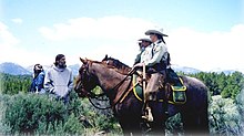
A horse patrol of the Law Enforcement & Investigations unit
 
The U.S. Forest Service Law Enforcement & Investigations unit (LEI), headquartered in Washington, D.C., is a federal law enforcement agency of the U.S. government. It is responsible for enforcement of federal laws and regulations governing national forest lands and resources. All Law Enforcement Officers and Special Agents Receive their training through Federal Law Enforcement Training Center (FLETC). 

Operations are divided into two major functional areas:
  • Law enforcement: uniformed, high-visibility enforcement of laws
  • Investigations: special agents who investigate crimes against property, visitors, and employees
Uniformed Law Enforcement Officers (LEOs) enforce federal laws and regulations governing national forest lands and resources. LEOs also enforce some or all state laws on National Forest Lands. As part of that mission, LEOs carry firearms, defensive equipment, make arrests, execute search warrants, complete reports, and testify in court. They establish a regular and recurring presence on a vast amount of public lands, roads, and recreation sites. The primary focus of their jobs is the protection of natural resources, protection of Forest Service employees and the protection of visitors. To cover the vast and varied terrain under their jurisdiction, they use Ford Crown Victoria Police Interceptors, special service SUVs, horses, K-9 units, helicopters, snowmobiles, dirt bikes, and boats. 

Special Agents are criminal investigators who plan and conduct investigations concerning possible violations of criminal and administrative provisions of the Forest Service and other statutes under the United States Code. Special agents are normally plainclothes officers who carry concealed firearms, and other defensive equipment, make arrests, carry out complex criminal investigations, present cases for prosecution to U.S. Attorneys, and prepare investigative reports. All field agents are required to travel a great deal and usually maintain a case load of ten to fifteen ongoing criminal investigations at one time. Criminal investigators occasionally conduct internal and civil claim investigations.

National Forest System

Forest Service team uses a 106 mm Recoilless Rifle for avalanche control at Mammoth Mountain in the Inyo National Forest in California. Note the Minarets in background.
 
The 193 million acres (780,000 km2) of public land that are managed as national forests and grasslands are collectively known as the National Forest System. These lands are located in 44 states, Puerto Rico, and the Virgin Islands and comprise about 9% of the total land area in the United States. The lands are organized into 155 national forests and 20 national grasslands. The mission of the National Forest System is to protect and manage the forest lands so they best demonstrate the sustainable multiple-use management concept, using an ecological approach, to meet the diverse needs of people.

State and Private Forestry

The mission of the State and Private Forestry program is to provide technical and financial assistance to private landowners, state agencies, tribes, and community resource managers to help sustain the United States' urban and rural forests and to protect communities and the environment from wildland fires, insects, disease, and invasive plants. The program employs approximately 537 staff located at 17 sites throughout the country. The delivery of the State and Private Forestry program is carried out by eight National Forest System regions and the Northeastern Area.

Research and development

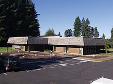
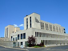
The U.S. Forest Service R&D lab in Olympia, Washington
 
The research and development (R&D) arm of the U.S. Department of Agriculture (USDA) Forest Service works to improve the health and use of the United States' forests and grasslands. Research has been part of the Forest Service mission since the agency's inception in 1905. Today, Forest Service researchers work in a range of biological, physical, and social science fields to promote sustainable management of United States' diverse forests and rangelands. Research employs about 550 scientists and several hundred technical and support staff, located at 67 sites throughout the United States and in Puerto Rico. Discovery and technology development and transfer is carried out through seven research stations. 

Research focuses on informing policy and land management decisions and includes addressing invasive insects, degraded river ecosystems, or sustainable ways to harvest forest products. The researchers work independently and with a range of partners, including other agencies, academia, nonprofit groups, and industry. The information and technology produced through basic and applied science programs is available to the public for its benefit and use. 

In addition to the Research Stations, the USFS R&D branch also leads several National Centers such as the National Genomics Center for Wildlife and Fish Conservation.

International programs

The Forest Service plays a key role in formulating policy and coordinating U.S. support for the protection and sound management of the world's forest resources. It works closely with other agencies such as USAID, the State Department, and the Environmental Protection Agency, as well as with nonprofit development organizations, wildlife organizations, universities, and international assistance organizations. The Forest Service's international work serves to link people and communities striving to protect and manage forests throughout the world. The program also promotes sustainable land management overseas and brings important technologies and innovations back to the United States. The program focuses on conserving key natural resource in cooperation with countries across the world.

Activities

More than 80% of the 193 million acres (780,000 km2) of land managed by the United States Forest Service is in the western states. This map shows USFS lands as a percentage of total land area in each state.
 
Although a large volume of timber is logged every year, not all National Forests are entirely forested. There are tidewater glaciers in the Tongass National Forest in Alaska and ski areas such as Alta, Utah in the Wasatch-Cache National Forest. In addition, the Forest Service is responsible for managing National Grasslands in the midwest. Furthermore, areas designated as wilderness by acts of Congress, prohibit logging, mining, road and building construction and land leases for purposes of farming and or livestock grazing. 

Since 1978, several Presidents have directed the USFS to administer National Monuments inside of preexisting National Forests.
The Forest Service also manages Grey Towers National Historic Site in Milford, Pennsylvania, the home and estate of its first Chief, Gifford Pinchot.

Fighting fires

Smokey Bear poster
 
In August 1944, to reduce the number of forest fires, the Forest Service and the Wartime Advertising Council began distributing fire education posters featuring a black bear. The poster campaign was a success; the black bear would later be named "Smokey Bear", and would, for decades, be the "spokesbear" for the Forest Service. Smokey Bear has appeared in innumerable TV commercials; his popular catch phrase, "Only YOU can prevent forest fires", is one of the most widely recognized slogans in the United States. A recent study found that 95% of the people surveyed could complete the phrase when given the first few words.

In September 2000, the Departments of Agriculture and the Interior developed a plan to respond to the fires of 2000, to reduce the impacts of these wildland fires on rural communities, and to ensure sufficient firefighting resources in the future. The report is entitled "Managing the Impacts of Wildfire on Communities and the Environment: A Report to the President In Response to the Wildfires of 2000"—The National Fire Plan for short. The National Fire Plan continues to be an integral part of the Forest Service today. The following are important operational features of the National Fire Plan:
  • Federal Wildland Fire Management Policy: The 1995 Federal Wildland Fire Management Policy and the subsequent 2001 Federal Wildland Fire Management Policy act as the foundation of the National Fire Plan.
  • Basic Premise of the National Fire Plan: Investing now in an optimal firefighting force, hazardous fuels reduction, and overall community protection will provide for immediate protection and future cost savings.
  • Funding: Initially (2001), the National Fire Plan provided for an additional $1,100,994,000 for the Forest Service for a total wildland fire management budget of $1,910,193,000. In 2008, the total amount for the Forest Service in wildland fire management (not including emergency fire suppression funding) is $1,974,276,000.
In August 2014, Tom Vilsack, the Secretary of Agriculture, announced that the agency will have to put $400 to $500 million in wildfire prevention projects on hold because funding for firefighting is running low as the fiscal year ends. The decision is meant to preserve resources for fighting active fires burning in California, Oregon, Washington and Idaho. Politicians of both parties have indicated that they believe the current funding structure is broken, but they have not agreed on steps to fix the funding allocation.

Popular culture

Lassie with Robert Bray as U.S. Forest Ranger Corey Stuart
 
The U.S. Forest Service achieved widespread awareness during the 1960s, as it became the setting for the long running classic TV show Lassie, with storylines focusing on Lassie's adventures with various forest rangers.

The iconic collie's association with the Forest Service led to Lassie receiving numerous awards and citations from the U.S. Senate and the Department of Agriculture, and was partly responsible for a bill regarding soil and water pollution that was signed into law in early 1968 by President Lyndon Johnson, which was dubbed by some as "The Lassie Program".

Controversies

The history of the Forest Service has been fraught with controversy, as various interests and national values have grappled with the appropriate management of the many resources within the forests. These values and resources include grazing, timber, mining, recreation, wildlife habitat, and wilderness. Because of continuing development elsewhere, the large size of National Forests have made them de facto wildlife reserves for a number of rare and common species. In recent decades, the importance of mature forest for the spotted owl and a number of other species led to great changes in timber harvest levels. 

In the 1990s, the agency was involved in scandal when it illegally provided surplus military aircraft to private contractors for use as airtankers.

Another controversial issue is the policy on road building within the National Forests. In 1999, President Clinton ordered a temporary moratorium on new road construction in the National Forests to "assess their ecological, economic, and social values and to evaluate long-term options for their management." Five and half years later, the Bush administration replaced this with a system where each state could petition the Forest Service to open forests in their territory to road building. 

Some years the agency actually loses money on its timber sales.

A 2017 draft report describing the legal basis which provides federal land managers a scope of decision making authority exceeding that of state fish and game departments has proven unexpectedly controversial.

In 2018 the Forest Service is reprimanded by the 4th U.S. Circuit Court of Appeals. The Service had issued permits for the Atlantic Coast Pipeline to build through parts of the George Washington and Monongahela National Forests and a right of way across the Appalachian Trail - in violation of both the National Forest Management Act and the National Environmental Policy Act.
Forest

From Wikipedia, the free encyclopedia

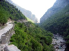
Forest on Mount Dajt, Albania
 
 
A forest is a large area dominated by trees. Hundreds of more precise definitions of forest are used throughout the world, incorporating factors such as tree density, tree height, land use, legal standing and ecological function. According to the widely used Food and Agriculture Organization definition, forests covered 4 billion hectares (9.9×10⁹ acres) (15 million square miles) or approximately 30 percent of the world's land area in 2006.

Forests are the dominant terrestrial ecosystem of Earth, and are distributed around the globe. Forests account for 75% of the gross primary production of the Earth's biosphere, and contain 80% of the Earth's plant biomass. Net primary production is estimated at 21.9 gigatonnes carbon per year for tropical forests, 8.1 for temperate forests, and 2.6 for boreal forests.

Forests at different latitudes and elevations form distinctly different ecozones: boreal forests around the poles, tropical forests around the Equator, and temperate forests at the middle latitudes. Higher elevation areas tend to support forests similar to those at higher latitudes, and amount of precipitation also affects forest composition. 

Human society and forests influence each other in both positive and negative ways. Forests provide ecosystem services to humans and serve as tourist attractions. Forests can also affect people's health. Human activities, including harvesting forest resources, can negatively affect forest ecosystems.

Definition

Forest in the Scottish Highlands
 
Although forest is a term of common parlance, there is no universally recognised precise definition, with more than 800 definitions of forest used around the world. Although a forest is usually defined by the presence of trees, under many definitions an area completely lacking trees may still be considered a forest if it grew trees in the past, will grow trees in the future, or was legally designated as a forest regardless of vegetation type.

There are three broad categories of forest definitions in use: administrative, land use, and land cover. Administrative definitions are based primarily upon the legal designations of land, and commonly bear little relationship to the vegetation growing on the land: land that is legally designated as a forest is defined as a forest even if no trees are growing on it. Land use definitions are based upon the primary purpose that the land serves. For example, a forest may be defined as any land that is used primarily for production of timber. Under such a land use definition, cleared roads or infrastructure within an area used for forestry, or areas within the region that have been cleared by harvesting, disease or fire are still considered forests even if they contain no trees. Land cover definitions define forests based upon the type and density of vegetation growing on the land. Such definitions typically define a forest as an area growing trees above some threshold. These thresholds are typically the number of trees per area (density), the area of ground under the tree canopy (canopy cover) or the section of land that is occupied by the cross-section of tree trunks (basal area). Under such land cover definitions, an area of land can only be known as forest if it is growing trees. Areas that fail to meet the land cover definition may be still included under while immature trees are establishing if they are expected to meet the definition at maturity.

Under land use definitions, there is considerable variation on where the cutoff points are between a forest, woodland, and savanna. Under some definitions, forests require very high levels of tree canopy cover, from 60% to 100%, excluding savannas and woodlands in which trees have a lower canopy cover. Other definitions consider savannas to be a type of forest, and include all areas with tree canopies over 10%.

Some areas covered with trees are legally defined as agricultural areas, e.g. Norway spruce plantations in Austrian forest law when the trees are being grown as Christmas trees and below a certain height.

Etymology

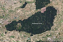
Since the 13th century, the Niepołomice Forest in Poland has had special use and protection. In this view from space, different coloration can indicate different functions.
 
The word forest comes from Middle English, from Old French forest (also forès) "forest, vast expanse covered by trees"; first introduced in English as the word for wild land set aside for hunting without the necessity in definition for the existence of trees. Possibly a borrowing (probably via Frankish or Old High German) of the Medieval Latin word foresta "open wood", foresta was first used by Carolingian scribes in the Capitularies of Charlemagne to refer specifically to the king's royal hunting grounds. The term was not endemic to Romance languages (e.g. native words for "forest" in the Romance languages evolved out of the Latin word silva "forest, wood" (English sylvan); cf. Italian, Spanish, Portuguese selva; Romanian silvă; Old French selve); and cognates in Romance languages, such as Italian foresta, Spanish and Portuguese floresta, etc. are all ultimately borrowings of the French word. 

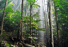
A forest near Vinitsa, North Macedonia
 
The exact origin of Medieval Latin foresta is obscure. Some authorities claim the word derives from the Late Latin phrase forestam silvam, meaning "the outer wood"; others claim the term is a latinisation of the Frankish word *forhist "forest, wooded country", assimilated to forestam silvam (a common practice among Frankish scribes). Frankish *forhist is attested by Old High German forst "forest", Middle Low German vorst "forest", Old English fyrhþ "forest, woodland, game preserve, hunting ground" (English frith), and Old Norse fýri "coniferous forest", all of which derive from Proto-Germanic *furhísa-, *furhíþija- "a fir-wood, coniferous forest", from Proto-Indo-European *perkwu- "a coniferous or mountain forest, wooded height". 

Uses of the word "forest" in English to denote any uninhabited area of non-enclosure are now considered archaic. The word was introduced by the Norman rulers of England as a legal term (appearing in Latin texts like the Magna Carta) denoting an uncultivated area legally set aside for hunting by feudal nobility.

Tywi Forest, Wales
 
These hunting forests were not necessarily wooded much, if at all. However, as hunting forests did often include considerable areas of woodland, the word "forest" eventually came to mean wooded land more generally. By the start of the 14th century, the word appeared in English texts, indicating all three senses: the most common one, the legal term and the archaic usage. Other terms used to mean "an area with a high density of trees" are wood, woodland, wold, weald, holt, frith and firth. Unlike forest, these are all derived from Old English and were not borrowed from another language. Some classifications now reserve the term woodland for an area with more open space between trees and distinguish among woodlands, open forests, and closed forests based on crown cover.

Evolutionary history

The first known forests on Earth arose in the Late Devonian (approximately 380 million years ago), with the evolution of Archaeopteris. Archaeopteris was a plant that was both tree-like and fern-like, growing to 10 metres (33 ft) in height. Archaeopteris quickly spread throughout the world, from the equator to subpolar latitudes. Archaeopteris formed the first forest by being the first known species to cast shade due to its fronds and forming soil from its roots. Archaeopteris was deciduous, dropping its fronds onto the forest floor. The shade, soil, and forest duff from the dropped fronds created the first forest. The shed organic matter altered the freshwater environment, slowing it down and providing food. This promoted freshwater fish.

Ecology

Forests account for 75% of the gross primary productivity of the Earth's biosphere, and contain 80% of the Earth's plant biomass. Forest ecosystems can be found in all regions capable of sustaining tree growth, at altitudes up to the tree line, except where natural fire frequency or other disturbance is too high, or where the environment has been altered by human activity.

The latitudes 10° north and south of the equator are mostly covered in tropical rainforest, and the latitudes between 53°N and 67°N have boreal forest. As a general rule, forests dominated by angiosperms (broadleaf forests) are more species-rich than those dominated by gymnosperms (conifer, montane, or needleleaf forests), although exceptions exist.

Forests sometimes contain many tree species within a small area (as in tropical rain and temperate deciduous forests), or relatively few species over large areas (e.g., taiga and arid montane coniferous forests). Forests are often home to many animal and plant species, and biomass per unit area is high compared to other vegetation communities. Much of this biomass occurs below ground in the root systems and as partially decomposed plant detritus. The woody component of a forest contains lignin, which is relatively slow to decompose compared with other organic materials such as cellulose or carbohydrate.

Components

Even, dense old-growth stand of beech trees (Fagus sylvatica) prepared to be regenerated by their saplings in the understory, in the Brussels part of the Sonian Forest.
 
A forest consists of many components that can be broadly divided into two categories that are biotic (living) and abiotic (non-living) components. The living parts include trees, shrubs, vines, grasses and other herbaceous (non-woody) plants, mosses, algae, fungi, insects, mammals, birds, reptiles, amphibians, and microorganisms living on the plants and animals and in the soil.

Layers

 
Spiny forest at Ifaty, Madagascar, featuring various Adansonia (baobab) species, Alluaudia procera (Madagascar ocotillo) and other vegetation

A forest is made up of many layers. The main layers of all forest types are the forest floor, the understory and the canopy. The emergent layer exists in tropical rainforests. Each layer has a different set of plants and animals depending upon the availability of sunlight, moisture and food.
  • Forest floor contains decomposing leaves, animal droppings, and dead trees. Decay on the forest floor forms new soil and provides nutrients to the plants. The forest floor supports ferns, grasses, mushroom and tree seedlings.
  • Understory is made up of bushes, shrubs, and young trees that are adapted to living in the shades of the canopy.
  • Canopy is formed by the mass of intertwined branches, twigs and leaves of the mature trees. The crowns of the dominant trees receive most of the sunlight. This is the most productive part of the trees where maximum food is produced. The canopy forms a shady, protective "umbrella" over the rest of the forest.
  • Emergent layer exists in the tropical rain forest and is composed of a few scattered trees that tower over the canopy.

Types

A dry sclerophyll forest in Sydney, which is dominated by eucalyptus trees.
 
Forests can be classified in different ways and to different degrees of specificity. One such way is in terms of the biome in which they exist, combined with leaf longevity of the dominant species (whether they are evergreen or deciduous). Another distinction is whether the forests are composed predominantly of broadleaf trees, coniferous (needle-leaved) trees, or mixed.
The number of trees in the world, according to a 2015 estimate, is 3 trillion, of which 1.4 trillion are in the tropics or sub-tropics, 0.6 trillion in the temperate zones, and 0.7 trillion in the coniferous boreal forests. The estimate is about eight times higher than previous estimates, and is based on tree densities measured on over 400,000 plots. It remains subject to a wide margin of error, not least because the samples are mainly from Europe and North America.

Forests can also be classified according to the amount of human alteration. Old-growth forest contains mainly natural patterns of biodiversity in established seral patterns, and they contain mainly species native to the region and habitat. In contrast, secondary forest is regrowing forest following timber harvest and may contain species originally from other regions or habitats.

Different global forest classification systems have been proposed, but none has gained universal acceptance. UNEP-WCMC's forest category classification system is a simplification of other more complex systems (e.g. UNESCO's forest and woodland 'subformations'). This system divides the world's forests into 26 major types, which reflect climatic zones as well as the principal types of trees. These 26 major types can be reclassified into 6 broader categories: temperate needleleaf; temperate broadleaf and mixed; tropical moist; tropical dry; sparse trees and parkland; and forest plantations. Each category is described as a separate section below.

Temperate needleleaf

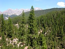
Temperate needleleaf forests mostly occupy the higher latitude regions of the Northern Hemisphere, as well as high altitude zones and some warm temperate areas, especially on nutrient-poor or otherwise unfavourable soils. These forests are composed entirely, or nearly so, of coniferous species (Coniferophyta). In the Northern Hemisphere pines Pinus, spruces Picea, larches Larix, firs Abies, Douglas firs Pseudotsuga and hemlocks Tsuga, make up the canopy, but other taxa are also important. In the Southern Hemisphere, most coniferous trees (members of the Araucariaceae and Podocarpaceae) occur in mixtures with broadleaf species, and are classed as broadleaf and mixed forests.

Temperate broadleaf and mixed

Broadleaf forest in Bhutan
 
Temperate broadleaf and mixed forests include a substantial component of trees in the Anthophyta. They are generally characteristic of the warmer temperate latitudes, but extend to cool temperate ones, particularly in the southern hemisphere. They include such forest types as the mixed deciduous forests of the United States and their counterparts in China and Japan, the broadleaf evergreen rainforests of Japan, Chile and Tasmania, the sclerophyllous forests of Australia, central Chile, the Mediterranean and California, and the southern beech Nothofagus forests of Chile and New Zealand.

Tropical moist

There are many different types of tropical moist forests, with lowland evergreen broad leaf tropical rainforests, for example várzea and igapó forests and the terra firma forests of the Amazon Basin; the peat swamp forests, dipterocarp forests of Southeast Asia; and the high forests of the Congo Basin. Seasonal tropical forests, perhaps the best description for the colloquial term "jungle", typically range from the rainforest zone 10 degrees north or south of the equator, to the Tropic of Cancer and Tropic of Capricorn. Forests located on mountains are also included in this category, divided largely into upper and lower montane formations on the basis of the variation of physiognomy corresponding to changes in altitude.

Tropical dry

Tropical dry forests are characteristic of areas in the tropics affected by seasonal drought. The seasonality of rainfall is usually reflected in the deciduousness of the forest canopy, with most trees being leafless for several months of the year. However, under some conditions, e.g. less fertile soils or less predictable drought regimes, the proportion of evergreen species increases and the forests are characterised as "sclerophyllous". Thorn forest, a dense forest of low stature with a high frequency of thorny or spiny species, is found where drought is prolonged, and especially where grazing animals are plentiful. On very poor soils, and especially where fire or herbivory are recurrent phenomena, savannas develop.

Sparse trees and parkland

Taiga forest near Saranpaul in the northeast Ural Mountains, Khanty–Mansia, Russia. Trees include Picea obovata (dominant on right bank), Larix sibirica, Pinus sibirica, and Betula pendula.
 
Sparse trees and savanna are forests with lower canopy cover of trees. They occur principally in areas of transition from forested to non-forested landscapes. The two major zones in which these ecosystems occur are in the boreal region and in the seasonally dry tropics. At high latitudes, north of the main zone of boreal forest, growing conditions are not adequate to maintain a continuous closed forest cover, so tree cover is both sparse and discontinuous. This vegetation is variously called open taiga, open lichen woodland, and forest tundra. A savanna is a mixed woodland grassland ecosystem characterized by the trees being sufficiently widely spaced so that the canopy does not close. The open canopy allows sufficient light to reach the ground to support an unbroken herbaceous layer consisting primarily of grasses. Savannas maintain an open canopy despite a high tree density.

Forest plantations

Forest plantations are generally intended for the production of timber and pulpwood. Commonly mono-specific and/or composed of introduced tree species, these ecosystems are not generally important as habitat for native biodiversity. However, they can be managed in ways that enhance their biodiversity protection functions and they can provide ecosystem services such as maintaining nutrient capital, protecting watersheds and soil structure, and storing carbon.

Societal significance

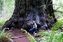
Redwood tree in northern California redwood forest, where many redwood trees are managed for preservation and longevity, rather than being harvested for wood production
 

Forests provide a diversity of ecosystem services including:
Some researchers state that forests do not only provide benefits, but can in certain cases also incur costs to humans. Forests may impose an economic burden, diminish the enjoyment of natural areas, reduce the food producing capacity of grazing land  and cultivated land, reduce biodiversity reduce available water for humans and wildlife, harbour dangerous or destructive wildlife, and act as reservoirs of human and livestock disease.

The management of forests is often referred to as forestry. Forest management has changed considerably over the last few centuries, with rapid changes from the 1980s onwards culminating in a practice now referred to as sustainable forest management. Forest ecologists concentrate on forest patterns and processes, usually with the aim of elucidating cause-and-effect relationships. Foresters who practice sustainable forest management focus on the integration of ecological, social, and economic values, often in consultation with local communities and other stakeholders.

Priest River winds through mountains with a checkerboard design of trees to its east
Priest River winding through Whitetail Butte with lots of forestry to the east—these lot patterns have existed since the mid-19th century. The white patches reflect areas with younger, smaller trees, where winter snow cover shows up brightly to the astronauts. Dark green-brown squares are parcels
 
Humans have generally decreased the amount of forest worldwide. Anthropogenic factors that can affect forests include logging, urban sprawl, human-caused forest fires, acid rain, invasive species, and the slash and burn practices of swidden agriculture or shifting cultivation. The loss and re-growth of forest leads to a distinction between two broad types of forest, primary or old-growth forest and secondary forest. There are also many natural factors that can cause changes in forests over time including forest fires, insects, diseases, weather, competition between species, etc. In 1997, the World Resources Institute recorded that only 20% of the world's original forests remained in large intact tracts of undisturbed forest. More than 75% of these intact forests lie in three countries—the boreal forests of Russia and Canada and the rainforest of Brazil.

In 2010, the United Nations Food and Agriculture Organization reported that world deforestation, mainly the conversion of tropical forests to agricultural land, had decreased over the past ten years but still continues at a high rate in many countries. Globally, around 13 million hectares of forests were converted to other uses or lost through natural causes each year between 2000 and 2010 as compared to around 16 million hectares per year during the 1990s. The study covered 233 countries and areas. Brazil and Indonesia, which had the highest loss of forests in the 1990s, have significantly reduced their deforestation rates. China instituted a ban on logging, beginning in 1998, due to the erosion and flooding that it caused. In addition, ambitious tree planting programmes in countries such as China, India, the United States and Vietnam – combined with natural expansion of forests in some regions – have added more than seven million hectares of new forests annually. As a result, the net loss of forest area was reduced to 5.2 million hectares per year between 2000 and 2010, down from 8.3 million hectares annually in the 1990s. In 2015, a study for Nature Climate Change showed that the trend has recently been reversed, leading to an "overall gain" in global biomass and forests. This gain is due especially to reforestation in China and Russia. However new forests are not completely equivalent to old growth forests in terms of species diversity, resilience and carbon capture. On September 7, 2015, the Food and Agriculture Organization of the United Nations released a new study stating that, over the last 25 years, the global deforestation rate has decreased by 50% due to improved management of forests and greater government protection.

Smaller areas of woodland in cities may be managed as urban forestry, sometimes within public parks. These are often created for human benefits; Attention Restoration Theory argues that spending time in nature reduces stress and improves health, while forest schools and kindergartens help young people to develop social as well as scientific skills in forests. These typically need to be close to where the children live, for practical logistics.

Canada

Canada has about 4,020,000 square kilometres (1,550,000 sq mi) of forest land. More than 90% of forest land is publicly owned and about 50% of the total forest area is allocated for harvesting. These allocated areas are managed using the principles of sustainable forest management, which includes extensive consultation with local stakeholders. About eight percent of Canada’s forest is legally protected from resource development. Much more forest land—about 40 percent of the total forest land base—is subject to varying degrees of protection through processes such as integrated land use planning or defined management areas such as certified forests.

By December 2006, over 1,237,000 square kilometres of forest land in Canada (about half the global total) had been certified as being sustainably managed. Clearcutting, first used in the latter half of the 20th century, is less expensive, but devastating to the environment, and companies are required by law to ensure that harvested areas are adequately regenerated. Most Canadian provinces have regulations limiting the size of clear-cuts, although some older clear-cuts can range upwards of 110 square kilometres (27,000 acres) in size which was cut over several years.

Latvia

Latvian Pine Forest in Ķegums Municipality
 
Latvia has about 3,270,000 hectares (12,626 sq mi) of forest land which equates to 50.6% of Latvia's total area (24,938 sq mi). 1,510,000 hectares of forest land (46.3% of total forest land) is publicly owned and 1,750,000 hectares of forest land (53.7% of total forest land) is in private hands. Latvia's forests have been steadily increasing over the years which is in contrast to many other nations, mostly due to the forestation of land not used for agriculture. In 1935 there was only 1,757,000 hectares of forest, today this has increased by more than 150%. Birch is the most common tree at 28.2% followed by pine (26,9%), spruce (18.3%), grey alder (9.7%), aspen (8,0%), black alder (5.7%), oak/ash (1.2%) and finally hardwood making up the rest (2.0%).

United States

In the United States, most forests have historically been affected by humans to some degree, though in recent years improved forestry practices have helped regulate or moderate large scale or severe impacts. However, the United States Forest Service estimates a net loss of about 2 million hectares (4,942,000 acres) between 1997 and 2020; this estimate includes conversion of forest land to other uses, including urban and suburban development, as well as afforestation and natural reversion of abandoned crop and pasture land to forest. However, in many areas of the United States, the area of forest is stable or increasing, particularly in many northern states. The opposite problem from flooding has plagued national forests, with loggers complaining that a lack of thinning and proper forest management has resulted in large forest fires.

Operator (computer programming)

From Wikipedia, the free encyclopedia https://en.wikipedia.org/wiki/Operator_(computer_programmin...